land use mapping - ppt (2) - geosmart india c paliwal.pdf · direction, while actually land/fields...
TRANSCRIPT
By
INVESTIGATIONSINVESTIGATIONS ONON THETHE ACCURACYACCURACYASPECTSASPECTS ININ THETHE LANDLAND USE/LANDUSE/LAND COVERCOVERMAPPINGMAPPING USINGUSING REMOTEREMOTE SENSINGSENSINGSATELLITESATELLITE IMAGERYIMAGERY ––
M.C.PALIWALDepartment of Civil Engineering
NATIONAL INSTITUTE OF TECHNICAL TEACHERS’ TRAINING & RESEARCH, BHOPAL (M.P.), INDIA
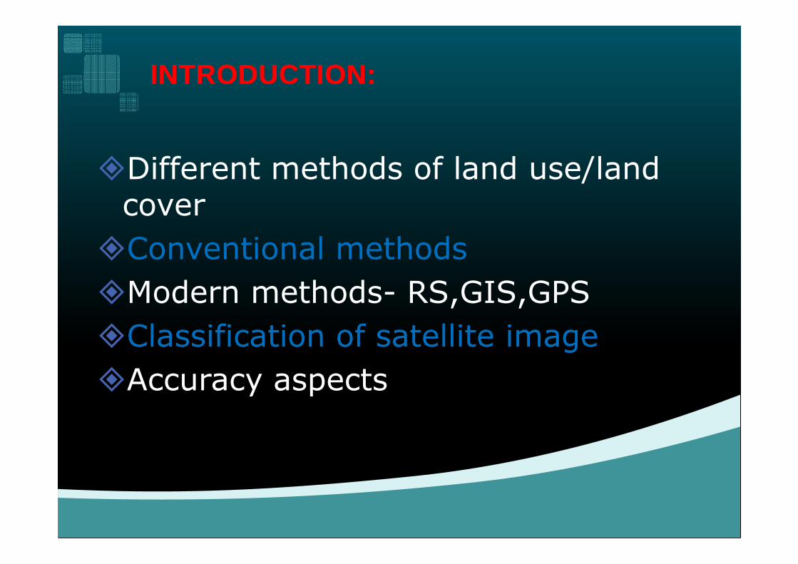
�Different methods of land use/land cover
�Conventional methods
�Modern methods- RS,GIS,GPS
INTRODUCTION:INTRODUCTION:
�Modern methods- RS,GIS,GPS
�Classification of satellite image
�Accuracy aspects

�Now a days due to rapid growth inurbanization and industrialization, there isincreasing pressure on land, water andenvironment. Urban sprawl may be foundeverywhere in major cities.
Need for land use maps:Need for land use maps:
everywhere in major cities.
�There are many problems related with conversion of agricultural land in to urban use. Every city is expanding in all directions resulting in large-scale changes in urban land use.

�Land cover is that which covers the surface ofthe earth and land use describeshow the land cover is modified.
�Land cover includes: water, grassland,
Land cover and Land use :Land cover and Land use :
�Land cover includes: water, grassland,forest, bare soil etc.
�Land use includes agricultural land,recreation area, built up land, etc.

�To make property maps and to do settlement.
�To conduct topographic survey for infrastructure development.
�To keep database records related to property.
The function of Land use The function of Land use maps:maps:
property.
�To evaluate the property value.
�To divide the property in case of disputes.
�To work with Board of Revenue, Public works departments, Utility companies etc.

�Chains to measure distances
�Old mechanical Theodolites
�Vernier Theodolites
Paper maps etc.
Conventional Methods:Conventional Methods:
�Paper maps etc.

� Chains data can be taken only in perpendicular direction, while actually land/fields is of Zig Zag shape.
� Chain data is always inaccurate. The land cost of today demands a more accurate method.
� The maps generated by manual methods can not be reproduced at user required scale. If scale has to be changed then whole map has to be redrawn.
Disadvantages of using Conventional Disadvantages of using Conventional Method:Method:
changed then whole map has to be redrawn.� Attribute data for a field can not be attached on a paper map.(i.e.The name of the owner, the area , the cost etc. has no relation with the map.)
� Decision making process using old paper maps becomes very cumbersome and some time it leads to wrong decision.

�Making a map using Coordinates rather than by Angles and distances.
�Area computation can be done using Total Stations as well as GPS then and there itself.
�Using Total Stations and Mapping Software the maps can be created automatically.
Modern methods:Modern methods:
maps can be created automatically.
�Map at any scale can be created because of availability of data in electronic format.
�A full-fledged GIS can be generated so that just be click of a key all the attributes corresponding to a land piece can be obtained.

• Conventional Survey Methods are very tedious and time consuming.
• Large Number of measurements are
Developments in the Surveying Techniques Developments in the Surveying Techniques and advantages of new mapping Techniques:and advantages of new mapping Techniques:
• Large Number of measurements are required to prepare a map.
• Automated Survey Techniques are simpler and easy to record survey measurements.
9

• Automatic and Laser level
• Total Stations
Global Positioning Systems (GPS)
AUTOMATED SURVEYING TECHNOLOGYAUTOMATED SURVEYING TECHNOLOGY
• Global Positioning Systems (GPS)
• Photogrammetric Survey
• Remote Sensing Methods (RS)
10

�In Conventional Survey all the field values are to be noted down in the field book and plotting is done manually in the office.
Ground based technique limitations Ground based technique limitations and advantages of satellite based and advantages of satellite based
techniques.techniques.
manually in the office.
�In GPS based surveys, the GPSReceiver records the Satellitesignal. GPS receiver can beattached to computer andautomatically plots the maps..
11
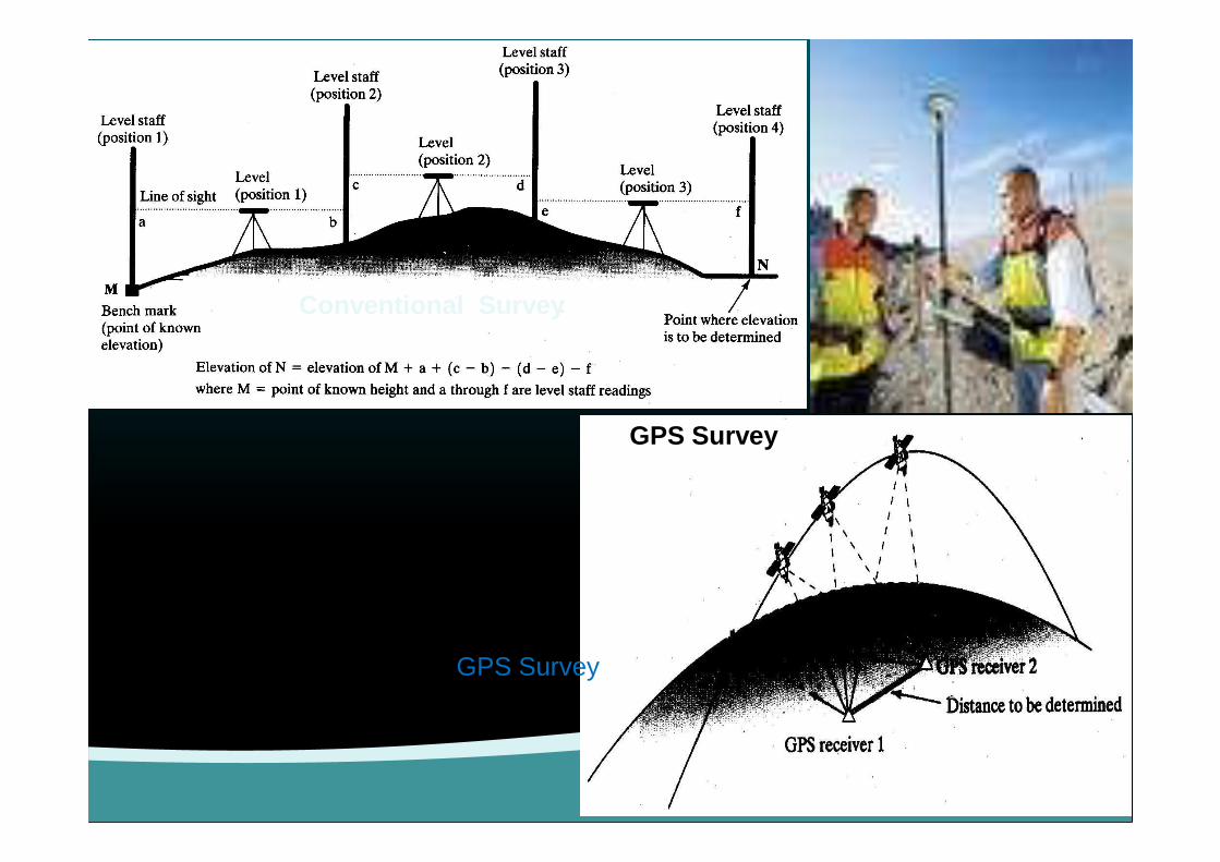
Conventional Survey
GPS Survey GPS Survey
12
GPS Survey

REMOTE SENSING [RS]REMOTE SENSING [RS]
A-Energy SourcesB-Radiation & AtmosphereC-Interaction with targetD-Recording of Energy by the sensor
Introduction Cont…
sensorE-Transmission, Recording and ProcessingF-Interpretation and AnalysisG-Application
http://sedac.ciesin.org/tg/guide_glue.jsp?rd=rs&ds=3

GIS AND ITS COMPONENTS
Component
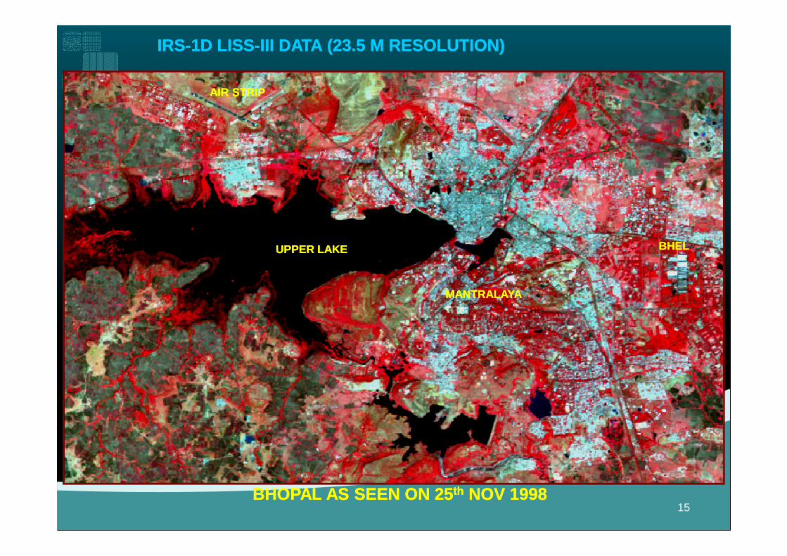
IRS-1D LISS-III DATA (23.5 M RESOLUTION)IRS-1D LISS-III DATA (23.5 M RESOLUTION)
UPPER LAKEUPPER LAKE
AIR STRIPAIR STRIP
BHELBHEL
BHOPAL AS SEEN ON 25th NOV 1998BHOPAL AS SEEN ON 25th NOV 1998
MANTRALAYAMANTRALAYA
15
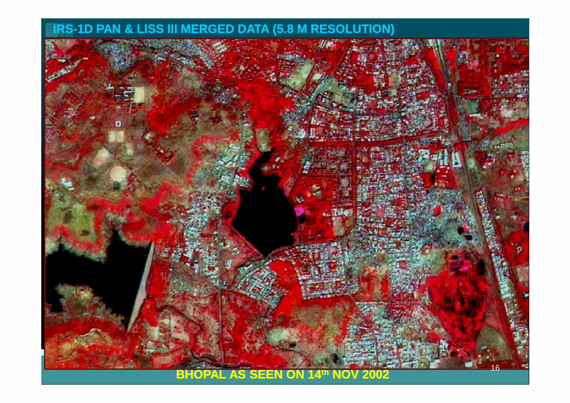
IRS-1D PAN & LISS III MERGED DATA (5.8 M RESOLUTION)IRS-1D PAN & LISS III MERGED DATA (5.8 M RESOLUTION)
BHOPAL AS SEEN ON 14th NOV 2002BHOPAL AS SEEN ON 14th NOV 200216
�Land cover maps derived from remotelysensed data inevitably contain error of varioustypes and degrees. It is therefore veryimportant that the nature of these errors bedetermined, to gauge their appropriatenessfor specific uses.
Accuracy aspects in land Accuracy aspects in land use/land cover maps:use/land cover maps:
for specific uses.
�Identifying and correcting the sources oferrors may increase the quality of mapinformation. Classification accuracyassessment is necessary for comparing theperformance of various classificationtechniques.
17
�Today, the error matrix has become the standard medium for reporting the accuracy of maps derived from remotely sensed data (Congalton and Green, 1993).
�More recent research into classification accuracy assessment has focused on factors influencing the accuracy of spatial data, such as sampling scheme and sample size, classification scheme, and spatial autocorrelation ( Congalton and Green, autocorrelation ( Congalton and Green, 1993).
�Other important considerations in classification accuracy assessment include ground verification techniques, and evaluation of all sources of error in the spatial data set.
18
�Assessing the accuracy of mapsgenerated from remotely senseddata requires evaluating bothpositional accuracy and thematicaccuracy. While these two
Accuracy aspects :Accuracy aspects :
positional accuracy and thematicaccuracy. While these twoaccuracies can be assessedseparately, they are very muchinterrelated and failure to considerboth of them is a serious mistake.
�Positional accuracy, a measure ofhow closely the imagery fits theground, is the most commonmeasure of map accuracy. In other
Positional Accuracy:Positional Accuracy:
measure of map accuracy. In otherwords, positional accuracy is theaccuracy of the location of a point inthe imagery with reference to itsphysical location on the ground.

�Thematic accuracy refers to the accuracy of a mapped land cover category at a particular time compared to what was actually on
Thematic Accuracy:Thematic Accuracy:
compared to what was actually on the ground at that time. Clearly, to perform a meaningful assessment of accuracy, land cover classifications must be assessed using data that are believed to be correct.
�A classification is not complete untilits accuracy is assessed.
�A classification error matrix isprepared based on training data.
Accuracy aspects :Accuracy aspects :
prepared based on training data.
�Error matrix compares the groundtruth and the corresponding resultsof an automated classification.
�Overall accuracy and individualaccuracy is calculated.
22
�KAPPA is a technique developed by Cohen(1960) and has been utilized for landcover and land use accuracy assessmentderived from remotely sensed data(Congalton et al., 1983; Rosenfield and
Need of reliable calibration and Need of reliable calibration and ground truthing in the map ground truthing in the map extraction.extraction.
(Congalton et al., 1983; Rosenfield andFitzpatrick-Lins, 1986; Gong and Howarth,1990).
�The result of performing a KAPPA analysisis the KHAT statistic (an estimate ofKAPPA) which is another measure ofaccuracy or agreement.
23

�In order to obtain unbiased groundreference information to compare withthe remote sensing classification mapand fill the error matrix values, weneed to determine the most
Trend in map extraction from Trend in map extraction from imagery using classification and imagery using classification and feature extraction.feature extraction.
need to determine the mostappropriate (i.e., minimum) samplesize acceptable for a valid statisticaltesting of accuracy of the land covermap. In addition, an appropriatesampling scheme must be used tolocate the sample points.
24
• Select various feasible land use categories in and around Bhopal city.
• Classify images by using ERDAS software and selecting different supervised methods as well as unsupervised methods.
• Verify classification accuracy by ground
METHODOLOGY:METHODOLOGY:
• Verify classification accuracy by ground truthing with the help of GPS as well as Google images.
• Digitize each class boundary on Googleimage as well as different classified imagesand superimpose then in ERDAS to verifyaccuracy.
25

�Bhopal City & adjoining area
�Some data of LISS-4 were purchased from NRSA Hyderabad for the date of field work done.
Study area and Data Study area and Data Resources:Resources:
for the date of field work done.
26


�After acquiring the satellite images of thestudy areas, classification of LISS 4 Imageof Bhopal was applied to the four methodsof classification.
�These are: Unsupervised classification inwhich the applied algorithm is Iterativewhich the applied algorithm is IterativeSelf-Organizing Data Analysis Technique(ISODATA)
�Three different supervised methods whichinclude Maximum likelihood, MahalanobisDistance, and Minimum Distance.

�After classified thematic maps weredeveloped, accuracy was tested bydifferent methods of accuracy assessment,and the post- classification process was theand the post- classification process was thelast process in classification.
�The software packages used forclassification
was ERDAS IMAGINE 11.
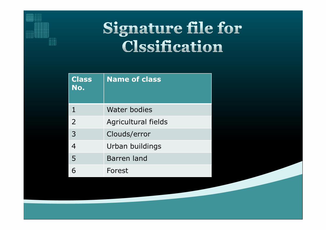
Class No.
Name of class
1 Water bodies
2 Agricultural fields
3 Clouds/error
4 Urban buildings
5 Barren land
6 Forest


1 2 3 4 5 6 Row Total
1 12 1 0 0 1 1 15
2 2 18 1 2 0 1 24
3 0 2 12 2 1 1 18
Ground Reference Im
age
Cla
ssifi
catio
n
.Overall Accuracy=(104/130) x100=80%
4 0 0 1 16 1 2 20
5 0 1 2 1 16 1 21
6 0 0 0 0 2 30 32
Column Total
14 22 16 21 21 36 130Imag
e C
lass
ifica
tion
Maximum Likelihood Method:
Calculate Producer’s Accuracy for each class and User’s Accuracy for each class .

�Class 1=(12/15)x100=80.00%
�Class 2=(18/24)x100=75.00%
�Class 3=(12/18)x100=66.67%
Class 4=(16/20)x100=80.00%�Class 4=(16/20)x100=80.00%
�Class 5=(16/21)x100=76.19%
�Class 6=(30/32)x100=93.75%
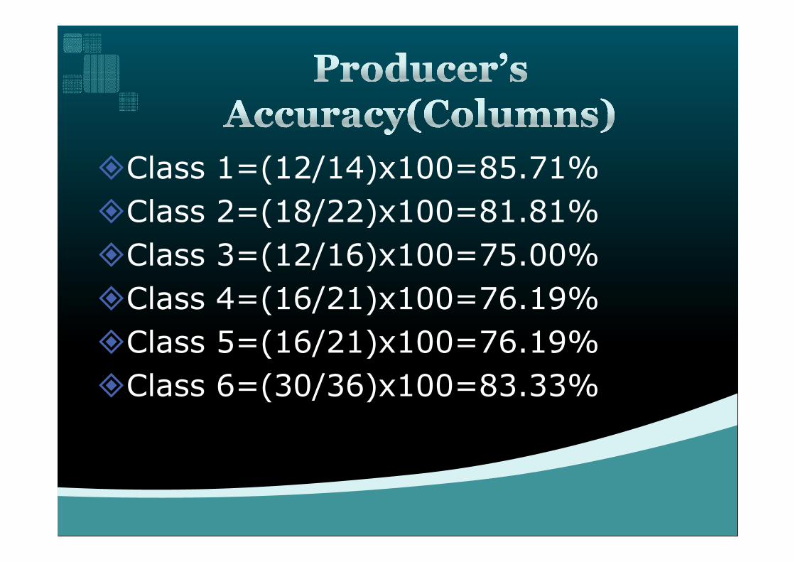
�Class 1=(12/14)x100=85.71%
�Class 2=(18/22)x100=81.81%
�Class 3=(12/16)x100=75.00%
Class 4=(16/21)x100=76.19%�Class 4=(16/21)x100=76.19%
�Class 5=(16/21)x100=76.19%
�Class 6=(30/36)x100=83.33%

1 2 3 4 5 6 Row Total
1 10 1 0 0 2 2 15
2 1 25 1 1 2 2 32
Ground Reference Im
age
Cla
ssifi
catio
n
.Overall Accuracy=(107/140) x100=74.28%
3 0 2 14 2 1 1 20
4 0 1 1 16 2 2 22
5 0 1 2 1 14 2 20
6 1 2 1 0 2 25 31
Column Total
12 32 19 20 23 34 140
Imag
e C
lass
ifica
tion
Mahalanobis Distance Method:.
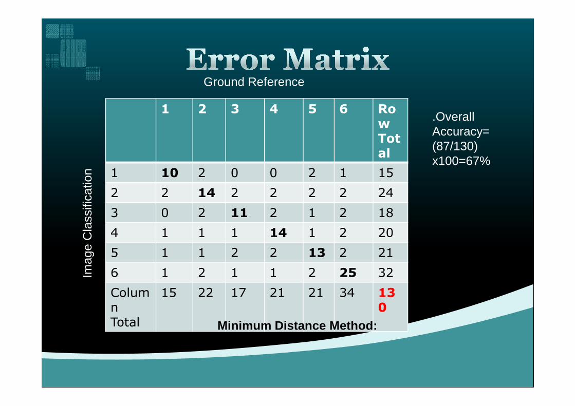
1 2 3 4 5 6 Row Total
1 10 2 0 0 2 1 15
2 2 14 2 2 2 2 24
Ground Reference Im
age
Cla
ssifi
catio
n
.Overall Accuracy=(87/130) x100=67%
3 0 2 11 2 1 2 18
4 1 1 1 14 1 2 20
5 1 1 2 2 13 2 21
6 1 2 1 1 2 25 32
Column Total
15 22 17 21 21 34 130
Imag
e C
lass
ifica
tion
Minimum Distance Method:
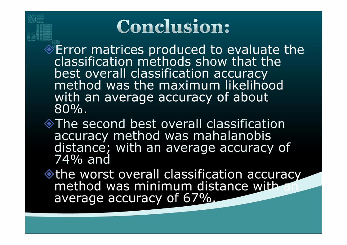
�Error matrices produced to evaluate the classification methods show that the best overall classification accuracy method was the maximum likelihood with an average accuracy of about 80%.
�The second best overall classification �The second best overall classification accuracy method was mahalanobisdistance; with an average accuracy of 74% and
�the worst overall classification accuracy method was minimum distance with an average accuracy of 67%.

�1.Jay Gao (2008):DETECTION OF CHANGES INLAND DEGRADATION IN NORTHEAST CHINAFROM LANDSAT TM AND ASTER DATA, TheInternational Archives of the Photogrammetry,Remote Sensing and Spatial InformationSciences. Vol. XXXVII. Part B7. Beijing-pp. 1533-
References:References:
Sciences. Vol. XXXVII. Part B7. Beijing-pp. 1533-1538
�2.Prakasam.C.(2010):Land use and land coverchange detection throughremote sensing approach: A case study ofKodaikanal taluk, Tamil nadu,INTERNATIONAL JOURNAL OF GEOMATICSAND GEOSCIENCES Volume 1, No 2, 2010 ,
42
�Yichun Xie et.al.(2008) ,Remote sensing imagery in vegetation mapping: a review, Journal of Plant Ecology VOLUME 1, NUMBER 1, PAGES 9–23 MARCH 2008
�Y.Babykalpana , K.ThanushKodi (2011):CLASSIFICATION OF LAND USE LAND
Contd.Contd.
(2011):CLASSIFICATION OF LAND USE LAND COVER CHANGE DETECTION USING REMOTELY SENSED DATA ,International Journal on Computer Science and Engineering (IJCSE) pp 1638-1644
�S. Balaselvakumar et .al. (2003),Remote Sensing Techniques for Land Use Mapping of Arjuna Basin, Tamil Nadu, Map Asia 2003
43
• Claudio Conese and Fabio MaseUi (1992), Use ofError Matrices to Improve Area Estimates withMaximum Likelihood Classification Procedures,REMOTE SENSING AND ENVIRONMENT 40:113-124(1992)• Ramachandra, T.V. and Uttam Kumar(2004):Geographic Resources Decision Support System forland use, land cover dynamics analysis , Proceedings ofthe FOSS/GRASS Users Conference - Bangkok,the FOSS/GRASS Users Conference - Bangkok,Thailand, 12-14 September 2004• Marcus E. Engdahl and Juha M. Hyyppä(2003): Land-Cover Classification Using Multitemporal ERS-1/2InSAR Data, IEEE TRANSACTIONS ONGEOSCIENCE AND REMOTE SENSING, VOL. 41, NO.7, JULY 2003
44
�M. A. Ibrahim et.al.(2004):Approaches toImprove Accuracy of Neural NetworkClassification of Images Dominated by MixedPixels, IEEE,(2004), pp. 568-571
�Nancy Thomas, et. al.(2003): A Comparison of
contd.contd.
�Nancy Thomas, et. al.(2003): A Comparison ofUrban Mapping Methods Using High-ResolutionDigital Imagery, Photogrammetric Engineering &Remote Sensing Vol. 69, No. 9, September 2003,pp. 963–972.
45

THANK YOU.