land tenure data gap: combining eo data into land governance...
TRANSCRIPT

2nd International Doctoral Seminar in filed of Geodesy, Geoinformatics and Geospace
1MSc. Cheonjae Lee | PhD Candidate | Institute of Geodesy, Geoinformatics and Landmanagement
© AP - https://www.apnews.com
Land Tenure Data Gap: Combining EO data into land
governance in Korean (re-)unification
Lee, Cheonjae
Technical University of Munich
Faculty of Civil, Geo and Environmental Engineering
Chair of Land Management
Dubrovnik, Croatia 09. May 2018

2nd International Doctoral Seminar in filed of Geodesy, Geoinformatics and Geospace
2
© AP - https://www.apnews.com
Doctoral Research Package (since October 2016)
MSc. Cheonjae Lee | PhD Candidate | Institute of Geodesy, Geoinformatics and Landmanagement
Theoretical
Empirical
Synthetic
Methodological
Book
Where I am
ARTICLE
No.1
THESIS
ARTICLE
NO.4
ARTICLE
NO.3
ARTICLE
NO.2
1st
semester
2nd
semester
3rd
semester
4th
semester
5th
semester
6th
semester

2nd International Doctoral Seminar in filed of Geodesy, Geoinformatics and Geospace
3
© AP - https://www.apnews.com
Research Outcomes
MSc. Cheonjae Lee | PhD Candidate | Institute of Geodesy, Geoinformatics and Landmanagement
A Peer-review Paper
• Lee, C. & de Vries, W.T., 2018, A Divided Nation: Rethinking and rescaling land tenure in Korean (re-)unification. Land Use
Policy.75 (2018), 127-136.
A Conference Paper
• Lee, C., Lu, Y., Wang, M., de Vries, W.T. & Chigbu, U.E., 2017, Transforming land governance: “one-country one-system”
versus “one-country two-systems”. International conference on Sustainable Urban and Regional Development – Research
and Policy Challenges for the Asia-Pacific Rim, Renmin University of China in collaboration with The Regional Science
Academy and Regional Science Association International, Beijing, China, 9-10 December, 2017.
A Workshop Presentation
• Lee, C., 2017, A Divided Nation: Land tenure, governance and Korean re-unification, National Post-Doc and Doctoral
Seminar in Land Management in Germany, Universität der Bundeswehr München, Munich, Germany, 6-7 July 2017. (Oral
presentation)

2nd International Doctoral Seminar in filed of Geodesy, Geoinformatics and Geospace
4
© AP - https://www.apnews.com
Table of Contents
I. Introduction
II. What we can observe from above
III. What we cannot observe from above
IV. What I want to observe
V. Challenges: land tenure data gap
VI. Questions © ABC - http://www.abc.net.au
MSc. Cheonjae Lee | PhD Candidate | Institute of Geodesy, Geoinformatics and Landmanagement
2nd International Doctoral Seminar in filed of Geodesy, Geoinformatics and Geospace
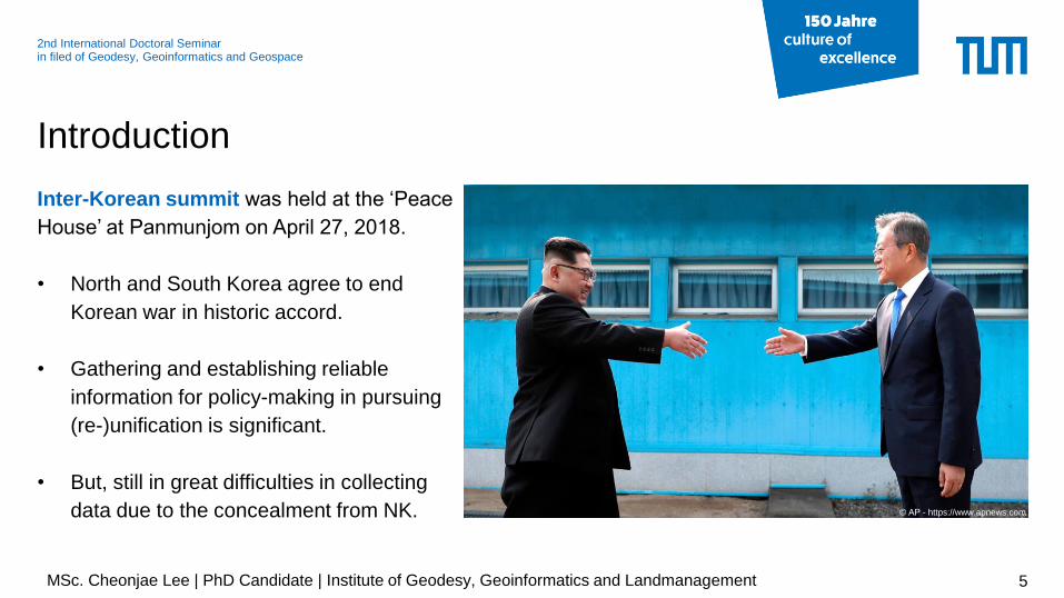
Inter-Korean summit was held at the ‘Peace
House’ at Panmunjom on April 27, 2018.
• North and South Korea agree to end
Korean war in historic accord.
• Gathering and establishing reliable
information for policy-making in pursuing
(re-)unification is significant.
• But, still in great difficulties in collecting
data due to the concealment from NK.
Introduction
5
© AP - https://www.apnews.com
MSc. Cheonjae Lee | PhD Candidate | Institute of Geodesy, Geoinformatics and Landmanagement

2nd International Doctoral Seminar in filed of Geodesy, Geoinformatics and Geospace
The availability of earth observation (EO) data
has been increased significantly in many
disciplines.
• Growing interest in measuring the context
of social phenomena and multi-level
analysis using EO data.
• Land use and land cover (LULC) change
information comprises essential
geographical spatial features.
Introduction
6
© NASA - https://neo.sci.gsfc.nasa.gov
MSc. Cheonjae Lee | PhD Candidate | Institute of Geodesy, Geoinformatics and Landmanagement

2nd International Doctoral Seminar in filed of Geodesy, Geoinformatics and Geospace
Governing land tenure is a critical component in
(re-)unification setting.
• Land tenure has a pivotal role in reforming
institutions, facilitating peacebuilding and
integration process and territorial development.
• How to re-shape land governance institutions are
a fundamental question focusing on land tenure
security, transferability, legitimacy and identity.
Introduction
7MSc. Cheonjae Lee | PhD Candidate | Institute of Geodesy, Geoinformatics and Landmanagement
2nd International Doctoral Seminar in filed of Geodesy, Geoinformatics and Geospace
Introduction
8MSc. Cheonjae Lee | PhD Candidate | Institute of Geodesy, Geoinformatics and Landmanagement
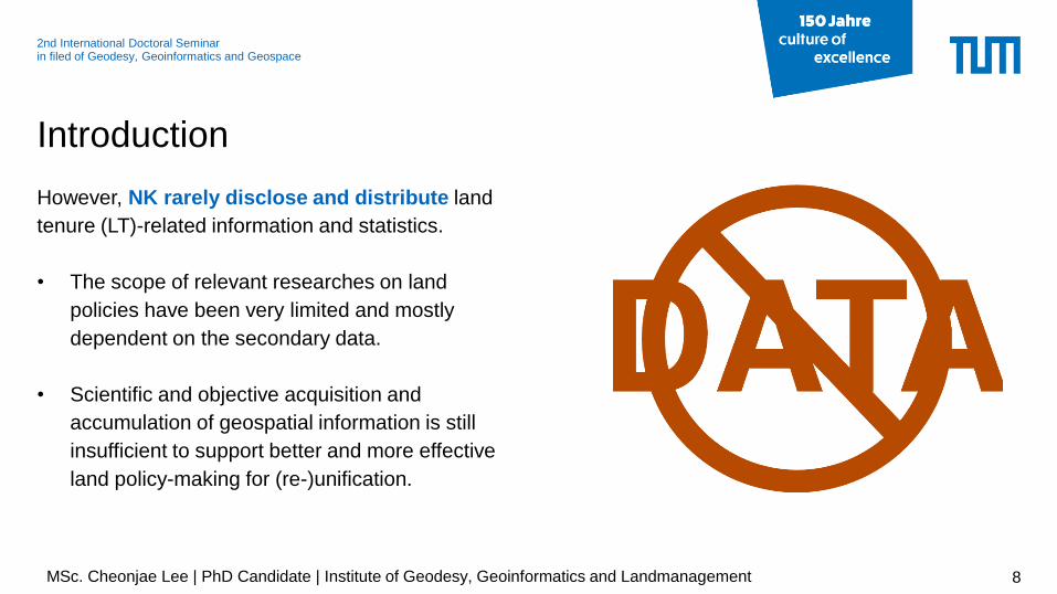
However, NK rarely disclose and distribute land
tenure (LT)-related information and statistics.
• The scope of relevant researches on land
policies have been very limited and mostly
dependent on the secondary data.
• Scientific and objective acquisition and
accumulation of geospatial information is still
insufficient to support better and more effective
land policy-making for (re-)unification.

2nd International Doctoral Seminar in filed of Geodesy, Geoinformatics and Geospace
Introduction
9MSc. Cheonjae Lee | PhD Candidate | Institute of Geodesy, Geoinformatics and Landmanagement
Many studies using EO data for NK as ‘inaccessible terrain’ have been proposed.
• Nevertheless, researchers and policy-makers still have faced with difficulties in incorporating LT-
related data with EO data due to:
Levels of accessibility: the limited access to NK data
Methodological levels: complexity of integrating LT attributes with EO data
Analytical levels: Its lower reliability and validity of acquired information

2nd International Doctoral Seminar in filed of Geodesy, Geoinformatics and Geospace
Introduction
10
Thus, research Objectives are:
RO 1.Potential availability of EO dataTo review the potential availability of EO data and techniques with high-resolution
imagery in Korean (re-)unification settings
RO 2.Merging LT-related data with EO dataTo examine how existing and more traditional LT-related data can be synthesized and
visualized in conjunction with EO data into land management practices as well as
peace and conflict research
MSc. Cheonjae Lee | PhD Candidate | Institute of Geodesy, Geoinformatics and Landmanagement

2nd International Doctoral Seminar in filed of Geodesy, Geoinformatics and Geospace
• Satellites: LANDSAT 4, 5
• sensors: MMS (Multispectral Scanner System)
and TM (Thematic Mapper)
• Detections:
- (spatial) coastal features; roads and urban
areas; soil/ vegetation differentiation; land/water
boundaries etc.
- (temporal) deforestation; urban and suburban
development; changes in heat islands
vegetation/land use patterns etc.
What we can observe from above
11MSc. Cheonjae Lee | PhD Candidate | Institute of Geodesy, Geoinformatics and Landmanagement
© NASA - https://neo.sci.gsfc.nasa.gov

2nd International Doctoral Seminar in filed of Geodesy, Geoinformatics and Geospace
• Satellites: LANDSAT 7, 8, 9
• sensors: ETM + (Enhanced Thematic Mapper)
• Detections:
- (spatial) large buildings; forest stands; agricultural
plots etc.
- (temporal) changes in human infrastructure;
development patterns; migration patterns;
agricultural variations; urban/rural interchange etc.
What we can observe from above
12MSc. Cheonjae Lee | PhD Candidate | Institute of Geodesy, Geoinformatics and Landmanagement
© NASA - https://neo.sci.gsfc.nasa.gov

2nd International Doctoral Seminar in filed of Geodesy, Geoinformatics and Geospace
• Satellites: SPOT 1,2, 4, and 5
• sensors: Two HRV-IR (High Resolution Visible,
Infrared) push-broom sensors; High Resolution
Geometry (HRG); VEGETATION instrument
• Detections:
- (spatial) agriculture; land use, water resources,
geological applications; engineering applications;
forest monitoring; vegetation cover study etc.
- (temporal) deforestation; (sub)urban land use
changes; residential development etc.
What we can observe from above
13MSc. Cheonjae Lee | PhD Candidate | Institute of Geodesy, Geoinformatics and Landmanagement
© AIRBIS 2018 - https://www.intelligence-airbusds.com

2nd International Doctoral Seminar in filed of Geodesy, Geoinformatics and Geospace
• Satellites: IKONOS 1, 2
• sensors: MMS (Multispectral) and PAN
(Panchromatic)
• Detections:
- (spatial) roads; vehicles; buildings; infrastructures;
land use; agricultural uses; vegetation etc.
- (temporal) changes in human infrastructure;
development patterns; agricultural variations;
urban/rural interchange etc.
What we can observe from above
14MSc. Cheonjae Lee | PhD Candidate | Institute of Geodesy, Geoinformatics and Landmanagement
© AIRBIS 2018 - https://www.intelligence-airbusds.com
© NGII 2009

2nd International Doctoral Seminar in filed of Geodesy, Geoinformatics and Geospace
• Satellites: Quickbird
• sensors: MS (Multispectral) and PAN
(Panchromatic)
• Detections:
- (spatial) roads; vehicles; buildings; infrastructures;
land use; agricultural uses; vegetation etc.
- (temporal) changes in human infrastructure;
development patterns; agricultural variations;
urban/rural interchange etc.
What we can observe from above
15MSc. Cheonjae Lee | PhD Candidate | Institute of Geodesy, Geoinformatics and Landmanagement
© AIRBIS 2018 - https://www.intelligence-airbusds.com

2nd International Doctoral Seminar in filed of Geodesy, Geoinformatics and Geospace
City lights at night illustrate dramatically the relative economic importance of cities and a fairly reliable
indicator of where people live.
What we can observe from above
16
Instrument(s): ISS – Digital Camera
Acquired date: 30 January, 2014
Instrument(s): Suomi NPP - VIIRS
Acquired date: 24 September, 2012
© NASA - https://earthobservatory.nasa.gov © NASA - https://earthobservatory.nasa.gov
MSc. Cheonjae Lee | PhD Candidate | Institute of Geodesy, Geoinformatics and Landmanagement

2nd International Doctoral Seminar in filed of Geodesy, Geoinformatics and Geospace
The South Korean governments (e.g. MoU; MoE) and research institutions has already established
geospatial information using EO data (e.g. mainly using Landsat TM, MODIS, IRS-1C, Quickbird, SPOT-5,
RAPIDEYE, KOMPSAT-2).
What we can observe from above
17MSc. Cheonjae Lee | PhD Candidate | Institute of Geodesy, Geoinformatics and Landmanagement
© NGII 2009Instrument(s): KOMPSAT - 2

2nd International Doctoral Seminar in filed of Geodesy, Geoinformatics and Geospace
Socio-economic (SE) data is about humans,
human activities, and the space and/or structures
used to conduct human activities
• Sources of SE data include field surveys,
government statistics, government
administrative records, secondary data etc.
• Specific classes entails demographics,
housing, migration, transportation, economics
etc.
What we cannot observe from above
18
© AP - https://www.apnews.com
MSc. Cheonjae Lee | PhD Candidate | Institute of Geodesy, Geoinformatics and Landmanagement

2nd International Doctoral Seminar in filed of Geodesy, Geoinformatics and Geospace
Key sources of land tenure-related SE data as following:
• Population census (demographical data-oriented)
• Economic census (industry data-oriented)
• Agricultural census (farm economic data-oriented)
• Labour force statistics (workforce data-oriented)
• Land records (land parcel and ownership data-oriented)
• Transportation and infrastructure inventories (SOC data-oriented)
• Administrative records (regulatory / administrative data-oriented)
What we cannot observe from above
19MSc. Cheonjae Lee | PhD Candidate | Institute of Geodesy, Geoinformatics and Landmanagement
© NKNEWS 2017

2nd International Doctoral Seminar in filed of Geodesy, Geoinformatics and Geospace
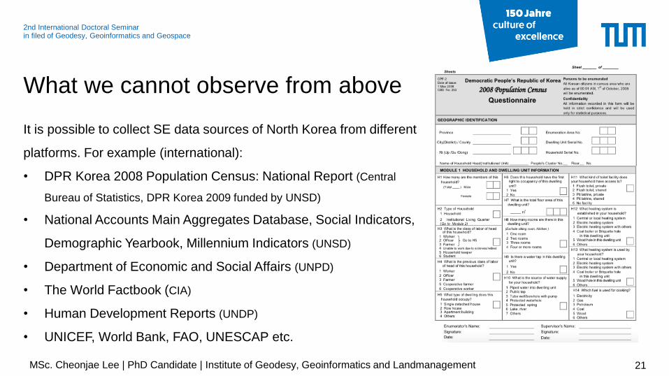
It is possible to collect SE data sources of North Korea from
different platforms. For example (domestic):
• North Korea Statistics (KOSIS, Korean Statistical Information
Services)
• Information Centre on North Korea (MoU, Ministry of Unification)
• Committee for the Five northern Korean Provinces (MOIS,
Ministry of Interior and Safety)
• Cadastral Achieves (NAK, National Achieves of Korea)
• A wide range of research institutions and internet-based
platforms also provide socio-economic data.
What we cannot observe from above
20
© AP - https://www.apnews.com
MSc. Cheonjae Lee | PhD Candidate | Institute of Geodesy, Geoinformatics and Landmanagement
2nd International Doctoral Seminar in filed of Geodesy, Geoinformatics and Geospace
It is possible to collect SE data sources of North Korea from different
platforms. For example (international):
• DPR Korea 2008 Population Census: National Report (Central
Bureau of Statistics, DPR Korea 2009 funded by UNSD)
• National Accounts Main Aggregates Database, Social Indicators,
Demographic Yearbook, Millennium Indicators (UNSD)
• Department of Economic and Social Affairs (UNPD)
• The World Factbook (CIA)
• Human Development Reports (UNDP)
• UNICEF, World Bank, FAO, UNESCAP etc.
What we cannot observe from above
21
© AP - https://www.apnews.com
MSc. Cheonjae Lee | PhD Candidate | Institute of Geodesy, Geoinformatics and Landmanagement

2nd International Doctoral Seminar in filed of Geodesy, Geoinformatics and Geospace
Relationship among land-cover using EO data and socio-economic variables has been established in regional
science field and major applications include: slum detection; quality of life index; house value estimation;
urban growth; population estimation; and social vulnerability assessment (Patino & Duque, 2013).
What I want to observe
22MSc. Cheonjae Lee | PhD Candidate | Institute of Geodesy, Geoinformatics and Landmanagement
Source: Weeks et al., 2007

2nd International Doctoral Seminar in filed of Geodesy, Geoinformatics and Geospace
What I want to observe
23MSc. Cheonjae Lee | PhD Candidate | Institute of Geodesy, Geoinformatics and Landmanagement
Source: Wurm & Taubenböck, 2018
Source: Kevin & Duke, 2012

2nd International Doctoral Seminar in filed of Geodesy, Geoinformatics and Geospace
What I want to observe
24MSc. Cheonjae Lee | PhD Candidate | Institute of Geodesy, Geoinformatics and Landmanagement
Source: Xie et al., 2016

2nd International Doctoral Seminar in filed of Geodesy, Geoinformatics and Geospace
Many initiatives are tackling the LT data challenge that
make land and resource rights information more
accurate and accessible (Peterson & Stevens, 2014).
• LandMark Map (Global platforms)
• WRI Rights to Resources Map (WRI)
• Focus on Land in Africa (FOLA)
• Mapping for Rights (Rainforest Foundation)
• Land Portal (ILC)
• OpenTitle (Thomson Reuters)
• Country- and regional-focused mapping platforms
(e.g. RAISG; AMAN; Open Development Cambodia; the
Sarawak Geoportal etc.)
What I want to observe
25
Source: http://www.landmarkmap.org
MSc. Cheonjae Lee | PhD Candidate | Institute of Geodesy, Geoinformatics and Landmanagement
2nd International Doctoral Seminar in filed of Geodesy, Geoinformatics and Geospace
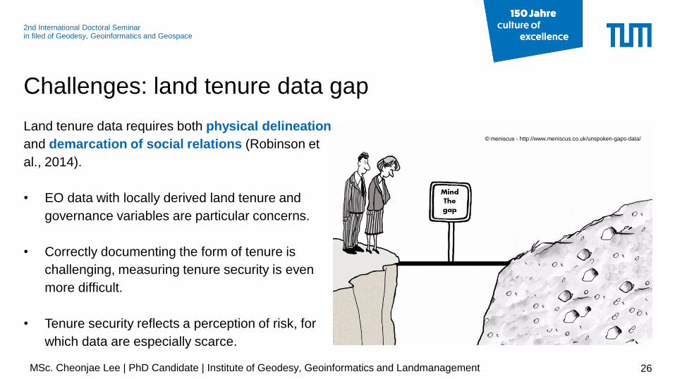
Land tenure data requires both physical delineation
and demarcation of social relations (Robinson et
al., 2014).
• EO data with locally derived land tenure and
governance variables are particular concerns.
• Correctly documenting the form of tenure is
challenging, measuring tenure security is even
more difficult.
• Tenure security reflects a perception of risk, for
which data are especially scarce.
Challenges: land tenure data gap
26
© meniscus - http://www.meniscus.co.uk/unspoken-gaps-data/
MSc. Cheonjae Lee | PhD Candidate | Institute of Geodesy, Geoinformatics and Landmanagement

2nd International Doctoral Seminar in filed of Geodesy, Geoinformatics and Geospace
• A lack of theoretical foundations linking EO data and LT-
related SE data for accurate data (re-)interpretation
• A lack of knowledge of how to derive reliable values for
the LT-related SE data
• An issue of LT-related SE data simplification and
trivialization.
• Integrating LT-related data and EO data requires the
fusion not only of data, but also of quite different scientific
traditions
Challenges: land tenure data gap
27MSc. Cheonjae Lee | PhD Candidate | Institute of Geodesy, Geoinformatics and Landmanagement
2nd International Doctoral Seminar in filed of Geodesy, Geoinformatics and Geospace
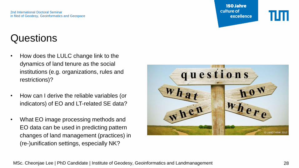
• How does the LULC change link to the
dynamics of land tenure as the social
institutions (e.g. organizations, rules and
restrictions)?
• How can I derive the reliable variables (or
indicators) of EO and LT-related SE data?
• What EO image processing methods and
EO data can be used in predicting pattern
changes of land management (practices) in
(re-)unification settings, especially NK?
Questions
28MSc. Cheonjae Lee | PhD Candidate | Institute of Geodesy, Geoinformatics and Landmanagement
© LANDTHINK 2012
29
THANK YOU
FOR YOUR
ATTENTION!
ANY QUESTIONS?
NO? GREAT! BYE.
MSc. Cheonjae Lee
Dubrovnik, Croatia 09. May 2018