land budget for growth area triangle
TRANSCRIPT

Land Budget for Growth Area Triangle Introduction
1. This paper looks at the assumptions regarding the land take for the Growth Area Triangle and the potential supply of land. In doing this, it treats the major proposal at Rackheath as a given, but only in the sense that there is a specific area of land under the control of the promoters and they have a specific number of dwellings referred to in their promotional literature.
2. The assumptions regarding the Rackheath proposal are that it is promoted
on the site of 310.15 hectares and will consist of 4145 houses.
Land Requirement
3. In order to arrive at a total of 10,000 dwellings, if 4145 are within the low carbon community at Rackheath, there is a residual requirement for 5,855 in the remainder of the growth triangle.
4. At 30 dwellings per hectare net, these would require 195 hectares.
5. The annex to this paper shows the infrastructure likely to require specific
sites. It is drawn from the latest draft Integrated Development Programme section covering the north east sector. Some will relate to other parts of the northeast, outside the growth area triangle and some is assumed to relate to Rackheath.
6. The infrastructure likely to relate to the remaining part of the growth area
triangle is as set out below
o Combined surgery for 2 GP’s and 3 dentists, not Rackheath N E 62 -assume 0.5 ha o Early years free-standing not Rackheath NE27 – assume 0.5 ha o East primary and early years 1 NE30 – assume 2.0 ha o East primary and early years 2 NE31 – assume 2.0 ha o expansion of north early years free-standing NE45 -assume 0.5 ha o 4 court indoor sports facility free-standing, not Rackheath NE50 –assume 0.5ha o Intermediate gas pressure connection outside Rackheath NE65 size not
applicable as linear utility o Local distributor link Salhouse road to Postwick NE5 [I km@ 20 m] - assume 2.0 ha o Local energy distribution NE15 size not applicable – network of utilities o North early years free-standing NE26 - assume 0.5 ha o Northeast community hall NE58 not Rackheath -assume 0.1 ha o Communities space and library NE 65 - assume 0.5 ha

o Waste recycling centre NE59 - assume 0.5 ha o north primary and early years1 NE29 - assume 2 ha o North primary and early years 2 NE 48 -assume 2 ha o Primary care centre NE.42 not Rackheath -assume 1.0 ha o Safer neighbourhood team co-located with primary care centre not at
Rackheath NE39 - included in above o Safer neighbourhood teams NE13 not Rackheath -assume 0.5 ha o Sprowston and Rackheath primary substation NE61 – assume 0.2 ha o Grid substation -assume 4.0 ha o District centre - assume 2.0 ha o Local centre -assume1.0 ha
Total 22.3 ha
7. In addition, there will be a need for green infrastructure. Based on the Council’s PPG 17 audit, there should be at least 140 hectares, possibly rising to 160 in total across the whole triangle. Of this it is assumed 60% will be in the remainder of triangle outside the Rackheath development. This implies a need for 84 to 96 hectares. However, around between 67% and 76% of this consist of natural and semi-natural open space, and Parks and gardens comprising formal open space. These could well be included with the land regarded as constrained e.g. historic parkland, Woodland, land under public safety zone or Airport noise contour. This would account for 60 to 68 hectares of the open space requirement leaving 24 – 28 ha to find.
8. Together the land required is therefore
Residential - 195 ha Social/utilities - 22 ha Green - 26 ha Total - 243 ha
9. In addition, as well as specific allocations, some further land would be needed for other uses such as employment.
Land Supply
10. This compares with up to 400 hectares of land which has been promoted and could be made available for housing. The measured land excludes current allocations, ancient woodland, historic parkland, county wildlife sites, formal recreation areas and the airport public safety zone and noise contours. The areas are shown on map1. The total of up to 400 ha is derived from
• Total promoted land in triangle 842.22 hectares minus

• 310.15 hectares [ Rackheath development] • 20.09 north of Postwick hub [potential employment] • 21.48 further land north of Postwick hub [longer term potential
employment] • 9.97 triangle wood, Thorpe End [setting of Conservation Area] • 60.39 not owner promoted north east of Beeston Park but included in a
speculative promotion by Bidwells • 22.30 severed by Airport constraints from urban fringe • 8.44 north of Brook farm- [setting of Conservation area] • This leaves a “maximum” of 389.44 ha
11. Adding grade 1 and 2 agricultural land and areas of landscape value, as
defined in the local plan adopted in 2006, to the constraints, as shown on map 2, reduces the available land as follows.
o 579.66 hectares total area in the triangle promoted for development and
not covered by one of the constraints o Minus 310.15 hectares Rackheath low carbon community o Excluding the area between the Airport noise contours and the northern
distributor road would remove a further 10.30 hectares o This leaves 259.21 hectares promoted and unconstrained. o Excluding the land north of Postwick hub envisaged in the calculation
above as potential employment and would remove a further 10.32 hectares, reducing the land available for other uses to 248.89 hectares
12. In reality, the scope to accommodate development is likely to lie
somewhere between these extreme positions, in order to produce a coherent built form. This would involve evaluating the form of development against its impact on some of the constrained land, or seeking to bring other land into the equation.
o The total could be increased if unconstrained but unpromoted land to the north and east of Thorpe End were brought into the equation. This has been estimated at 50.06 hectares north of Plumstead Road and 8.88 ha south of Plumstead Road, and is shown measured on Map 2, but not indicated as promoted.
o The grade 2 agricultural land in the vicinity of Broadland Business Park represents a small parcel separated by the northern distributor road from the major part of the high quality agricultural land in the area. This would restore 34.36 hectares from the above calculation, though much of it may be more usefully considered as potential employment land.
o The creation of the longstanding link road proposal between the Broadland Business Park and Wroxham Road may alter the landscape in the vicinity of Brook Farm, north of Dussindale, and add an additional 19.57 hectares which has been promoted and is the subject of a planning application at mid 2010.

o While policies seek to protect the inherent qualities of County Wildlife Sites, the qualities may not be distributed evenly across all sites and it may be that some development can be accommodated so long as the inherent qualities are retained. A “charette” was undertaken in June/July 2010 to consider whether there is potential for some development within the woodland at Racecourse Plantation, Belmore Plantation and Brown’s Plantation, Thorpe St Andrew, which are County Wildlife Sites.
o A significant part of the grade 2 agricultural and west of Beeston Park is covered by the Airport noise contours. However if the remaining part were to be contemplated for development, this could add a further 68.28hectares east of North Walsham Road, and 51.40 ha west of North Walsham Road..
o It should be noted that between production of the two maps, Airport noise contours have been remodelled. The more recent map, map 2, shows individual contours extending down to the 54 db contour. The constrained area is reduced if the 57 db contour is adopted. This is the level which corresponds to PPG 24 category A for dwellings, where noise need not be a determining factor in granting planning permission, though clearly lower noise levels are preferable. This applies to daytime exposure with more restrictive limits on noise acceptable between 23.00 and 07.00. It should be noted that there is no scheduled night flying from Norwich International Airport, and so the 54 db contour can be regarded as a conservative measure.
Conclusion
13. The conclusion drawn is that there is sufficient land available to accommodate a well designed and attractive development consisting of a number of defined neighbourhoods each with appropriate community facilities, with scope to extend the strategic employment locations at Broadland Business Park in the long term, and at Rackheath as part of the low carbon development.
14. There is also scope to define communities by a well developed network of green infrastructure whose management and connectivity can be enhanced through the development. This also indicates that while the precise form of development should be subject to detailed masterplanning, the existing structure of the area gives sufficient clarity for a strategic allocation in the joint core strategy to be progressed to the development stage through a supplementary planning document, incorporating community engagement and participation in shaping it.

Annex List of social infrastructure in northeast Facilities likely to be in “Rest of North East”
o Combined surgery for 2 GP’s and 3 dentists, not Rackheath N E 62 -assume 0.5 ha o Early years free-standing not Rackheath NE27 – assume 0.5 ha o East primary and early years 1 NE30 – assume 2.0 ha o East primary and early years 2 NE31 – assume 2.0 ha o expansion of north early years free-standing N E45 -assume 0.5 ha o 4 court indoor sports facility free-standing, not Rackheath N E50 –assume 0.5ha o Intermediate gas pressure connection outside Rackheath N E65 size not
applicable as linear utility o Local distributor link Salhouse road to Postwick NE5 [I km@ 20 m] - assume 2.0 ha o Local energy distribution N. E.15 size not applicable – network of utilities o North early years free-standing NE26 - assume 0.5 ha o Northeast community hall N E.58 not Rackheath -assume 0.1 ha o Communities space and library NE 65 - assume 0.5 ha o Waste recycling center NE59 - assume 0.5 ha o north primary and early years1 NE29 - assume 2 ha o North primary and early years 2 NE 48 -assume 2 ha o Primary care centre NE.42 not Rackheath -assume 1.0 ha o Safer neighborhood team co-located primary care centre not at Rackheath N.
E.39 - included in above o Safer neighborhoods teams NE13 not Rackheath -assume 0.5 ha o Sprowston and Rackheath primary substation NE61 – assume 0.2 ha o Grid substation -assume 4.0 ha o District centre - assume 2.0 ha o Local centre -assume1.0 ha
Total 22.3 ha Facilities likely to be at Rackheath Low Carbon Community o Swimming pool: located at the secondary school NE 63 size included in
school o Community space and library co-located with the early years Rackheath
NE423 o Rackheath Low carbon community education center east free-standing early
years N. E. 46 assume 0.25 hectare o Expansion of Rackheath free-standing early years o Intermediate pressure gas connection at Rackheath N. E. 64
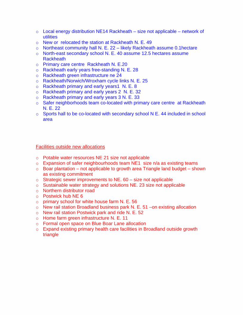
o Local energy distribution NE14 Rackheath – size not applicable – network of utilities
o New or relocated the station at Rackheath N. E. 49 o Northeast community hall N. E. 22 – likely Rackheath assume 0.1hectare o North-east secondary school N. E. 40 assume 12.5 hectares assume
Rackheath o Primary care centre Rackheath N. E.20 o Rackheath early years free-standing N. E. 28 o Rackheath green infrastructure ne 24 o Rackheath/Norwich/Wroxham cycle links N. E. 25 o Rackheath primary and early years1 N. E. 8 o Rackheath primary and early years 2 N. E. 32 o Rackheath primary and early years 3 N. E. 33 o Safer neighborhoods team co-located with primary care centre at Rackheath
N. E. 22 o Sports hall to be co-located with secondary school N E. 44 included in school
area
Facilities outside new allocations o Potable water resources NE 21 size not applicable o Expansion of safer neighbourhoods team NE1 size n/a as existing teams o Boar plantation – not applicable to growth area Triangle land budget – shown
as existing commitment o Strategic sewer improvements to NE. 60 – size not applicable o Sustainable water strategy and solutions NE. 23 size not applicable o Northern distributor road o Postwick hub NE 6 o primary school for white house farm N. E. 56 o New rail station Broadland business park N. E. 51 –on existing allocation o New rail station Postwick park and ride N. E. 52 o Home farm green infrastructure N. E. 11 o Formal open space on Blue Boar Lane allocation o Expand existing primary health care facilities in Broadland outside growth
triangle

Scale 1:30000
0.11
0.12
0.11
13.64
0.89
1.32
28.12
53.45
8.44 9.97
19.57 3.58
0.97
0.80 8.45
21.48
20.09
23.79
0.80
0.73
7.19
310.15 0.10
1.30
78.89
60.39
19.51
75.91
0.45
38.00
22.30
8.99 Possible Constraints
Legend
Employment Allocation
Housing Allocation
Areas of Land Promoted for Development
Strategic Land Reserve
Airport Noise
Permission for B1-B8 Use
Built AreaDesignated Green Space
Proposed NDRSafeguard Route
This map is reproduced from Ordnance Survey material with the permission of Ordnance Survey on behalf of the Controller of Her Majesty's Stationery Office © Crown copyright. Unauthorised reproduction infringes Crown copyright and may lead to prosecution or civil proceedings. (100018156) (2005)
Areas of Land Promoted for Development within the Growth Triangle and Identified Constraints
N
S
W E

Scale 1:30000
Possible Constraints
Legend
Employment Allocation
Housing Allocation
Areas of Land Promoted for Development
Agricultural Land Values 2&1
Airport Noise
Permission for B1-B8 Use
Safeguard RouteProposed NDR
Built AreaDesignated Green Space
50.06ha
8.88ha
68.28ha
51.40ha
5.58ha
2.97ha 0.54ha
10.30ha
23.66ha
53.45ha
10.03ha
7.61ha
3.76ha
71.79ha
53.45ha
0.80ha
0.11ha
1.60ha
0.97ha
0.12ha
3.58ha
5.21ha
1.60ha
0.89ha
3.73ha
6.59ha
5.37ha
23.79ha
7.19ha
0.80ha
18.97ha
0.10ha310.15ha
63db60db
57db54db
Land Promoted for Development & Constraints within the Growth Triangle
This map is reproduced from Ordnance Survey material with the permission of Ordnance Survey on behalf of the Controller of Her Majesty's Stationery Office © Crown copyright. Unauthorised reproduction infringes Crown copyright and may lead to prosecution or civil proceedings. (100018156) (2008)
N
S
W E