land and water form cards - researchparent.com
TRANSCRIPT
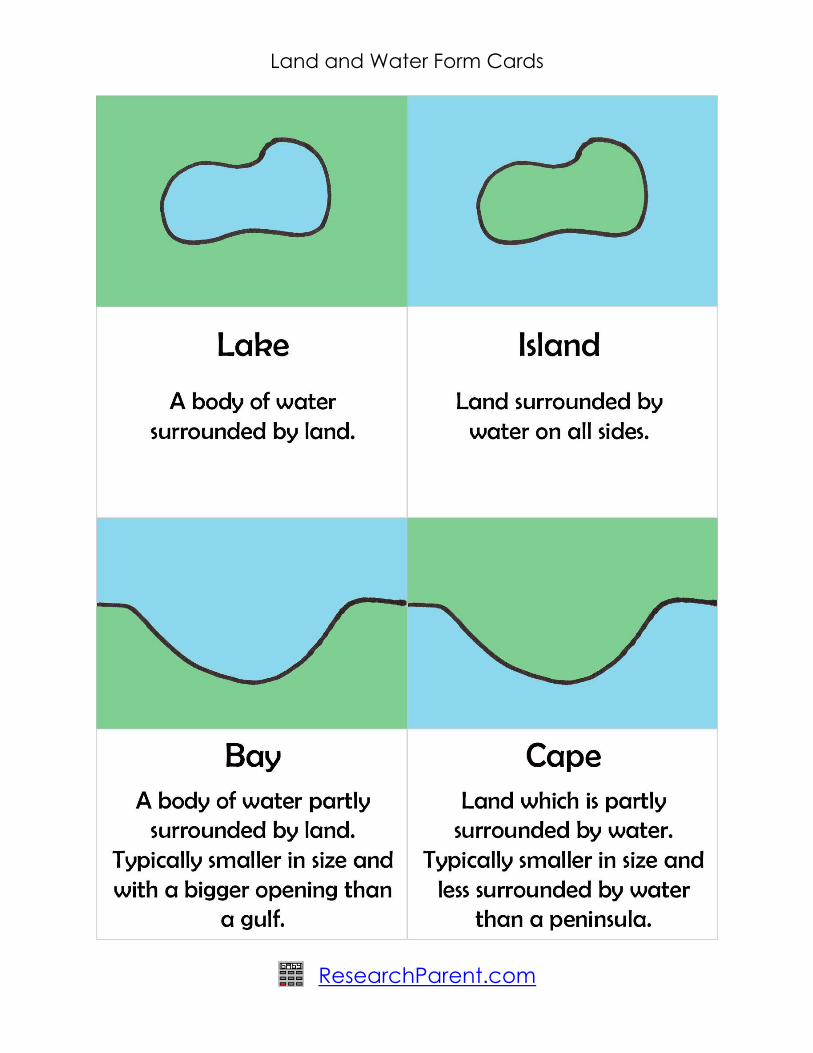
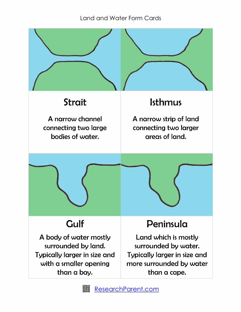

Land and Water Form Cards
ResearchParent.com
Land_and_Water_Form_Cards.pdf by ResearchParent.com is licensed under a
Creative Commons Attribution-ShareAlike 4.0 International License.
This document can be obtained at http://researchparent.com/land-and-water-
form-cards and includes material from the following sources:
"Lake Como Lecco Arm 1" by Stan Shebs. Licensed under CC BY-SA 3.0 via Wikimedia Commons
-
https://commons.wikimedia.org/wiki/File:Lake_Como_Lecco_Arm_1.jpg#/media/File:Lake_Com
o_Lecco_Arm_1.jpg
"Dove-Lake from South-2008" by Bjørn Christian Tørrissen - Own work by uploader,
http://bjornfree.com/galleries.html. Licensed under CC BY-SA 3.0 via Commons -
https://commons.wikimedia.org/wiki/File:Dove-Lake_from_South-2008.jpg#/media/File:Dove-
Lake_from_South-2008.jpg
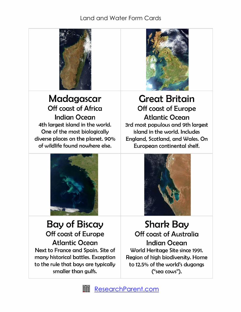
"Satellite image of Great Britain and Northern Ireland in April 2002" by Jacques Descloitres,
MODIS Land Rapid Response Team, NASA/GSFC - Cropped from:
http://visibleearth.nasa.gov/view_rec.php?id=3065. Licensed under Public Domain via
Commons -
https://commons.wikimedia.org/wiki/File:Satellite_image_of_Great_Britain_and_Northern_Ireland
_in_April_2002.jpg#/media/File:Satellite_image_of_Great_Britain_and_Northern_Ireland_in_April_2
002.jpg
"Satellite image of Madagascar in September 2003" by Unknown -
http://visibleearth.nasa.gov/view_rec.php?id=5769. Licensed under Public Domain via
Wikimedia Commons -
https://commons.wikimedia.org/wiki/File:Satellite_image_of_Madagascar_in_September_2003.jp
g#/media/File:Satellite_image_of_Madagascar_in_September_2003.jpg
"Bay of Biscay from Terra (2004-05-17)" by NASA - The MODIS scientific instrument, from this search
and this page. Licensed under Public Domain via Commons -
https://commons.wikimedia.org/wiki/File:Bay_of_Biscay_from_Terra_(2004-05-
17).jpg#/media/File:Bay_of_Biscay_from_Terra_(2004-05-17).jpg
"Shark Bay Phytoplankton in Bloom" by NASA - NASA's Image of the Day Gallery.[1]Full resolution
upload from http://www.nasa.gov/images/content/121761main_image_feature_363_ys_full.jpg.
Licensed under Public Domain via Commons -
https://commons.wikimedia.org/wiki/File:Shark_Bay_Phytoplankton_in_Bloom.jpg#/media/File:Sh
ark_Bay_Phytoplankton_in_Bloom.jpg
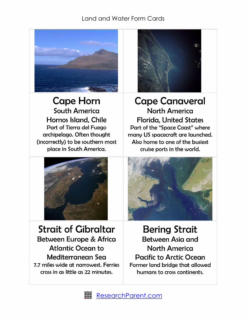
"Cabo de Hornos" by Original uploader was Buron444 at en.wikipedia - Transferred from
en.wikipedia; transferred to Commons by User:Frokor using CommonsHelper.. Licensed under
Public Domain via Commons -
https://commons.wikimedia.org/wiki/File:Cabo_de_Hornos.JPG#/media/File:Cabo_de_Hornos.J
PG

Land and Water Form Cards
ResearchParent.com
"Cape canaveral" by NASA - http://eol.jsc.nasa.gov/sseop/EFS/photoinfo.pl?PHOTO=STS043-84-
31. Licensed under Public Domain via Commons -
https://commons.wikimedia.org/wiki/File:Cape_canaveral.jpg#/media/File:Cape_canaveral.jpg
"STS059-238-074 Strait of Gibraltar" by NASA -
http://images.jsc.nasa.gov/luceneweb/caption_direct.jsp?photoId=STS059-238-
074https://www.flickr.com/photos/nasa2explore/9364207155/. Licensed under Public Domain via
Commons - https://commons.wikimedia.org/wiki/File:STS059-238-
074_Strait_of_Gibraltar.jpg#/media/File:STS059-238-074_Strait_of_Gibraltar.jpg
"Bering Strait" by PIA02638.tif from http://www.visibleearth.nasa.gov/cgi-bin/viewrecord?7049.
Licensed under Public Domain via Commons -
https://commons.wikimedia.org/wiki/File:Bering_Strait.jpeg#/media/File:Bering_Strait.jpeg
"IsthmusOfPanama". Licensed under Public Domain via Commons -
https://commons.wikimedia.org/wiki/File:IsthmusOfPanama.png#/media/File:IsthmusOfPanama.
png
"Manila satellite map" by http://www.terraprints.com - www.terraprints.com. Licensed under CC
BY 2.5 via Commons -
https://commons.wikimedia.org/wiki/File:Manila_satellite_map.jpg#/media/File:Manila_satellite_
map.jpg
"PersianGulf vue satellite du golfe persique" by NASA -
http://earthobservatory.nasa.gov/Newsroom/NewImages/Images/PersianGulf_AMO_2007332_lr
g.jpg. Licensed under Public Domain via Commons -
https://commons.wikimedia.org/wiki/File:PersianGulf_vue_satellite_du_golfe_persique.jpg#/medi
a/File:PersianGulf_vue_satellite_du_golfe_persique.jpg
"Gulf of Carpentaria-MODIS 250m" by Jeff Schmaltz, MODIS Land Rapid Response Team, NASA
GSFC - MODIS Image of the day August 1, 2008. Licensed under Public Domain via Commons -
https://commons.wikimedia.org/wiki/File:Gulf_of_Carpentaria-
MODIS_250m.jpg#/media/File:Gulf_of_Carpentaria-MODIS_250m.jpg
"Two-point-equidistant-asia". Licensed under Public Domain via Commons -
https://commons.wikimedia.org/wiki/File:Two-point-equidistant-asia.jpg#/media/File:Two-point-
equidistant-asia.jpg
"Baja peninsula (mexico) 250m". Licensed under Public Domain via Commons -
https://commons.wikimedia.org/wiki/File:Baja_peninsula_(mexico)_250m.jpg#/media/File:Baja_p
eninsula_(mexico)_250m.jpg
"SeaWiFS Image of Great Lakes from Space" by the SeaWiFS Project, NASA/Goddard Space
Flight Center, and ORBIMAGE. - http://visibleearth.nasa.gov/view_rec.php?id=1244. Licensed
under Public Domain via Wikimedia Commons -
https://commons.wikimedia.org/wiki/File:SeaWiFS_Image_of_Great_Lakes_from_Space.png#/m
edia/File:SeaWiFS_Image_of_Great_Lakes_from_Space.png

Land and Water Form Cards
ResearchParent.com
"GreatLakesAfrica" by NASA - A crop of [...] by Rhythm. Licensed under Public Domain via
Commons -
https://commons.wikimedia.org/wiki/File:GreatLakesAfrica.jpg#/media/File:GreatLakesAfrica.jp
g
"ISS-38 Galapagos Islands" by NASA - http://spaceflight.nasa.gov/gallery/images/station/crew-
38/html/iss038e000232.html. Licensed under Public Domain via Wikimedia Commons -
https://commons.wikimedia.org/wiki/File:ISS-38_Galapagos_Islands.jpg#/media/File:ISS-
38_Galapagos_Islands.jpg
"MODIS - Great Britain and Ireland - 2012-06-04 during heat wave" by Jeff Schmaltz, MODIS Land
Rapid Response Team, NASA GSFC (Goddard Space Flight Center) - Description text and image
both imported from http://modis.gsfc.nasa.gov/gallery/individual.php?db_date=2012-06-04.
Licensed under Public Domain via Commons - https://commons.wikimedia.org/wiki/File:MODIS_-
_Great_Britain_and_Ireland_-_2012-06-04_during_heat_wave.jpg#/media/File:MODIS_-
_Great_Britain_and_Ireland_-_2012-06-04_during_heat_wave.jpg