lake macdonald dam information sheet ford1ggft7m82h57a.cloudfront.net/s3fs-public/pdf...
TRANSCRIPT

IntroductionThis information sheet is for residents living downstream of Lake Macdonald Dam. It outlines how the dam has been designed and constructed, what Seqwater does to manage the dam, and how the dam performed during the heavy rainfall associated with ex-Tropical Cyclone Debbie in March 2017.
About Lake Macdonald DamLake Macdonald Dam is located in the Noosa hinterland on Six Mile Creek, about 4 kilometres north-east of Cooroy.
Lake Macdonald Dam was originally built in 1965 and raised in 1980 to increase its storage capacity. The dam is part of the SEQ Water Grid.
How the dam worksLake Macdonald Dam has a zoned earth and rockfill embankment with an un-gated spillway. This means when water reaches the level of the spillway, water flows over and into Six Mile Creek downstream.
Water flows into the dam from the surrounding catchment of some 49 square kilometres of rolling hills and a high proportion of rural residential land. Above the dam wall, one creek runs from Cooroy Mountain and another through the township of Cooroy before flowing into the dam.
The dam’s concrete un-gated spillway is located in the middle of the dam wall embankment. The spillway is made of compacted fill, reinforced concrete, and filter material.
The dam was raised in 1980 to its current level. The main dam wall has a maximum height of 11.5 metres and is 501 metres long. At full supply, the dam holds back 8,018 million litres of water and the lake surface is 95.32 metres above sea level.
Flood mitigationAll un-gated dams help mitigate flooding to some extent. The peak outflow from an un-gated dam during a flood event is less than the peak outflow that would have occurred had the dam not been built, because some water is held in the dam while it is spilling. This means that water flow slows down as floods pass through the dam.
As an un-gated dam, Seqwater has no control over water spilling from Lake Macdonald Dam once the dams full supply level is reached. It is not possible to influence the outflow from the dam during a flood event.
Seqwater’s primary responsibilities during flood events are to monitor the safety of the dam and provide dam outflow information to the relevant emergency agencies. Such agencies will generally be the Bureau of Meteorology and the local council responsible for the area impacted by the dam outflow. For Lake Macdonald Dam, this is Noosa Shire Council.
Dam safetyDams are long-life assets and require continual assessment, monitoring and maintenance. Queensland has a good dam safety record, but just like cars, dams need regular checks and maintenance to keep them in good working order. The engineering and safety features of cars have improved over time and so too have those of dams. Seqwater’s Dam Improvement Program is about upgrading our dams in line with the latest engineering standards, while meeting the current Queensland Dam Safety Guidelines.
Lake Macdonald is one of a number of dams identified for upgrade in the next six years. This will be the first major upgrade for the dam since it was built in 1965 and raised in 1980.
For more information about the program, visit seqwater.com.au/damimprovement.
Lake Macdonald Dam Information sheet for residents downstream December 2017
Quick factsWatercourse: Six Mile CreekLocation: About 4km north-east of CooroyCatchment area: 49.0km 2
Lake surface area: 260ha (at full supply level)Full supply capacity: 8018MLYear completed: 1965Crest level: 95.32m AHD (above sea level)Wall height: 11.5mOutlet system: Uncontrolled ‘ogee’ crestType of construction: Earth and rockfill damLength of dam wall: 501.0m
Lake Macdonald Dam information sheet
Other flood impactsYour local council provides information about potential flood risks in Noosa including mapping and tips on how to be prepared.
To find out about the impacts of localised flooding or flash flooding in your area, you should contact your local council noosa.qld.gov.au
Dam release notification serviceSeqwater provides updates about dam levels and spilling at seqwater.com.au and on 1800 613 122.
You can also register for email and SMS dam release notifications on our website or download the Seqwater public safety app (via Google Play or Apple’s App Store) to receive regular updates.
1800 771 497seqwater.com.au [email protected] facebook.com/seqwater @Seqwater
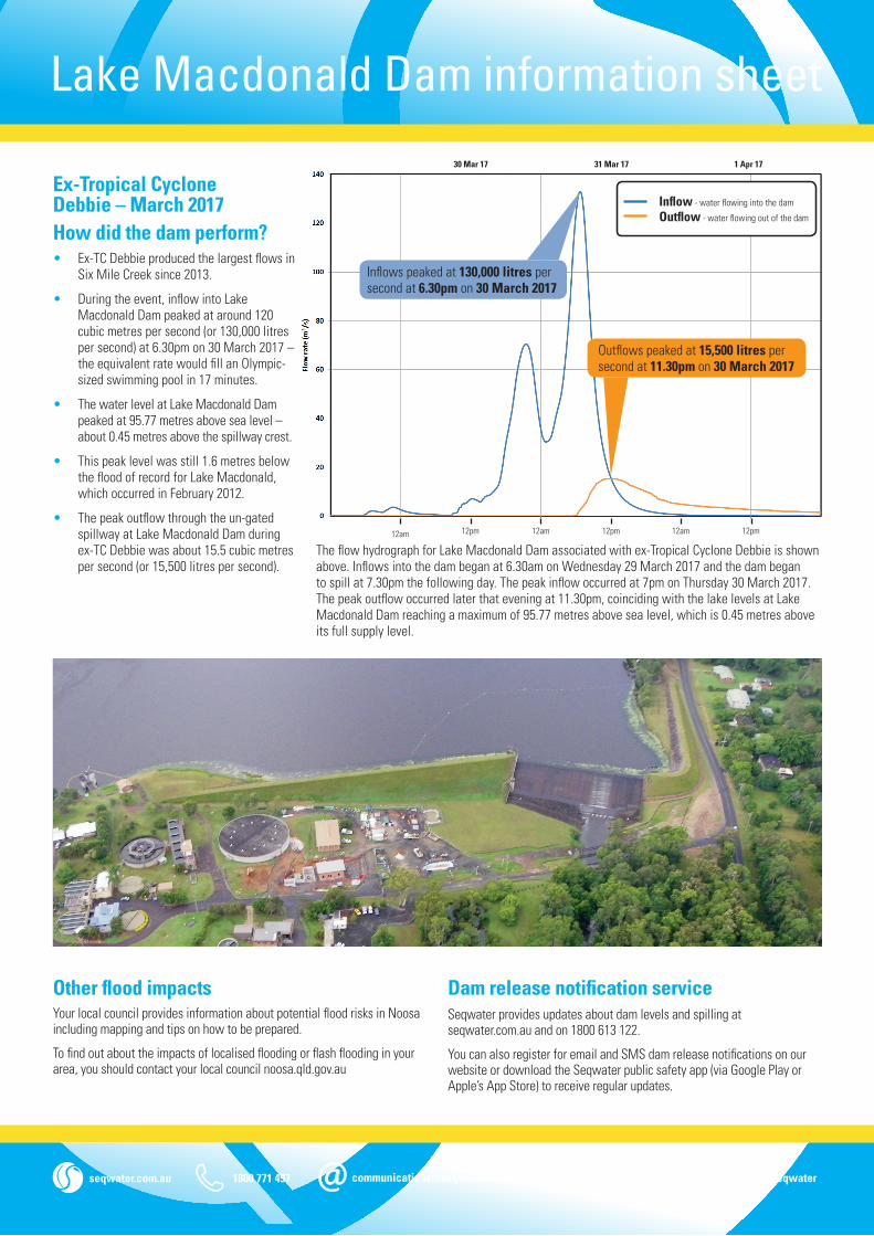
Ex-Tropical Cyclone Debbie – March 2017How did the dam perform?• Ex-TC Debbie produced the largest flows in
Six Mile Creek since 2013.
• During the event, inflow into Lake Macdonald Dam peaked at around 120 cubic metres per second (or 130,000 litres per second) at 6.30pm on 30 March 2017 – the equivalent rate would fill an Olympic-sized swimming pool in 17 minutes.
• The water level at Lake Macdonald Dam peaked at 95.77 metres above sea level – about 0.45 metres above the spillway crest.
• This peak level was still 1.6 metres below the flood of record for Lake Macdonald, which occurred in February 2012.
• The peak outflow through the un-gated spillway at Lake Macdonald Dam during ex-TC Debbie was about 15.5 cubic metres per second (or 15,500 litres per second).
Inflows peaked at 130,000 litres per second at 6.30pm on 30 March 2017
Outflows peaked at 15,500 litres per second at 11.30pm on 30 March 2017
Inflow - water flowing into the dam
Outflow - water flowing out of the dam
12am
31 Mar 17 1 Apr 17
12pm 12am 12pm 12am 12pm
30 Mar 17
The flow hydrograph for Lake Macdonald Dam associated with ex-Tropical Cyclone Debbie is shown above. Inflows into the dam began at 6.30am on Wednesday 29 March 2017 and the dam began to spill at 7.30pm the following day. The peak inflow occurred at 7pm on Thursday 30 March 2017. The peak outflow occurred later that evening at 11.30pm, coinciding with the lake levels at Lake Macdonald Dam reaching a maximum of 95.77 metres above sea level, which is 0.45 metres above its full supply level.