lake kapowsin aquatic reserve management plan · derrick toba, field assistant ... washington state...
TRANSCRIPT

Lake Kapowsin Aquatic Reserve
Management Plan
September 2016
N A
T
U
R
A
L
R E
S
O
U
R
C
E
S
Washington State Department of Natural Resources · Lake Kapowsin Aquatic Reserve Management Plan i
Acknowledgements
Washington State Department of Natural
Resources
Peter Goldmark, Commissioner of Public Lands
Megan Duffy, Deputy Supervisor, Aquatic Resources
Shoreline District
Derrick Toba, Field Assistant Division Manager
Wynnae Wright, Aquatic Land Manager
Hannah Blackstock, Aquatic Land Manager
Lake Kapowsin Aquatic Reserve
Planning Advisory Committee, 2015 - 2016 Amy Moreno-Sills, Futurewise
Andy Anderson, Graham/Kapowsin resident
Bud Rehberg, local resident, Friends of Pierce County
Jim Halmo, Graham/Kapowsin resident
Dave Risvold, Environmental Biologist, Pierce County Planning
Doug Wiedemeier, Habitat Biologist Washington
Department of Fish and Wildlife
Greg Volkhardt, City of Tacoma
Kimberly Freeman, Pierce County Parks and Recreation
Lloyd Fetterly, Tahoma Audubon
Matt Hamilton, Graham/Kapowsin resident
Rod Heupel, Western Bass Club
Phil Fix, Graham/Kapowsin resident
Russ Blount, Graham/Kapowsin resident
Russ Ladley, Puyallup Tribe
Steve Caromile, Freshwater Fish Biologist, Washington
Department of Fish and Wildlife
Lake Kapowsin Aquatic Reserve
Technical Advisory Committee, 2015
Carri J. LeRoy, Ph.D, Member of the Faculty, Environmental Studies Program The Evergreen State College
Isabel Ragland Water Quality Monitoring Program Manager Pierce Conservation District
Jim Gawel, Ph.D. Assoc. Prof. of Environmental Chemistry and Engineering, University of Washington Tacoma
Patrick T. Pringle Professor of Earth Science, Science Department Centralia College
Stephen Caromile
Freshwater Fish Biologist, Washington Department of Fish and Wildlife
Aquatic Resources Division
Kristin Swenddal, Division Manager
Michal Rechner, Assistant Division Manager
David Palazzi, Planning Program Manager
Roberta Davenport, Aquatic Reserves Program Manager
Betty Bookheim, Natural Resource Scientist
Jamie Kilgo, Environmental Planner
Angie Hong, Environmental Planner
Communications
Joe Smillie, DNR Communications
Principal Authors
Roberta Davenport, Aquatic Reserves Program Manager
Betty Bookheim, Natural Resource Scientist
Jamie Kilgo, Environmental Planner
Angie Hong, Environmental Planner
GIS and Mapping
Jamie Kilgo, Environmental Planner
Contributors
Brooke McIntryre, Puget SoundCorps Team
David Schroeder, Puget SoundCorps Team
Lori Price, DNR South Puget Sound Region
Cover Photo: Lake Kapowsin. Provided by Aquatic
Reserve Program
Copies of this report may be obtained from the
Washington State Department of Natural Resources
Aquatic Reserves Program or copied from the web
page. Copies may also be obtained by contacting:
Aquatic Reserves Program Manager Phone: 360-902-1100
E-mail: [email protected]
Web: www.dnr.wa.gov
Those needing this information in an alternative
format, please call TTY-711
Washington State Department of Natural Resources · Lake Kapowsin Aquatic Reserve Management Plan ii
Lake Kapowsin Aquatic Reserve
Draft Management Plan
AN ENVIRONMENTAL AQUATIC RESERVE
Washington State Department of Natural Resources
Aquatic Resources Division
September 22, 2016

Washington State Department of Natural Resources · Lake Kapowsin Aquatic Reserve Management Plan iii
Executive Summary The Lake Kapowsin Aquatic Reserve is established as an environmental reserve to protect important
native ecosystems, to facilitate collaborative partnerships, and to maintain existing uses and
recreational opportunities for current and future generations. Aquatic reserves benefit the public as
areas where natural ecological systems are enjoyed, restored, studied, and used for recreation. Lake
Kapowsin has relatively undeveloped shorelines, a unique and important geologic and cultural
history, a submerged forest, plentiful woody structure, floating log habitat, and extensive wetland
complexes. The natural character and predominately forested drainage basin of the lake are unusual
in the Puget Sound lowlands region. These qualities make the lake a popular destination for sport
fishing, waterfowl hunting, birdwatching, and boating.
Important Environmental Features Lake Kapowsin is a 512-acre low elevation freshwater lake in eastern Pierce County near the
community of Graham. It was created approximately 500 years ago when the Electron mudflow
rushed down the Puyallup Valley from the west slopes of Mount Rainier and dammed present-day
Kapowsin Creek. This natural dam flooded the valley floor and drowned a coniferous forest. Massive
stumps are still embedded in the lake bottom today.
The complex structure created by the remnant stumps and large wood provide valuable habitat for
fishes, amphibians, and invertebrates. The extensive wetlands support many small mammals and
amphibians, including beavers, river otters, Northwestern salamander, Northern red-legged frog,
rough-skinned newt and chorus frog. Lake Kapowsin provides essential nesting, rearing and foraging
habitat for both resident and migratory birds throughout the year.
Recreation and Public Access The aquatic reserve will protect important aquatic habitats used by fish and waterfowl ensuring that
future generations can continue to enjoy hunting, fishing, and boating at Lake Kapowsin. DNR
supports current uses and recreation at Lake Kapowsin. Washington Department of Fish and Wildlife
(WDFW) stocks Rainbow Trout and manages the lake as a mixed-species waterbody. DNR will
continue to work with WDFW and the local community to foster recreation and public access, and
support clean shorelines and a safe public access.
Collaborative Partnerships This plan provides the overarching vision for the aquatic reserve and the practical management
guidance for realizing that vision. The aquatic reserve goals and objectives can only be achieved by
cultivating broad partnerships on multiples scales – local, county, state. The values of the community
will help guide aquatic reserve management. Important aquatic resources will be protected and
recreational activities will be supported by connecting the diverse expertise of local residents,
recreational users, managers, and scientists.
Management Plan Organization The Aquatic Reserve Program and the Lake Kapowsin Planning Advisory Committee developed this
management plan during a collaborative planning process. This document presents a comprehensive

Washington State Department of Natural Resources · Lake Kapowsin Aquatic Reserve Management Plan iv
description of the natural environment (Appendix A) and human environment (Appendix B), and a
guidance for the management of the Lake Kapowsin Aquatic Reserve. The three management
sections are:
Conservation Targets: Identifies important native habitats and species, and unique
features that maintain biological diversity and sustain ecological function.
Management Guidance: Describes the desired future conditions, which will direct
management of the reserve during its 90-year term. The goals, objectives and strategies
provide the overall vision for the reserve’s desired future conditions.
Implementation Guidance: Describes collaborative partnerships and the role of the
Aquatic Reserve Program as facilitator working with partners and the community toward
common goals.
Management Goals This plan identifies the management strategies the Washington Department of Natural Resources will
employ to ensure Lake Kapowsin’s environmental quality supports existing uses and future
compatible uses. Below are the reserve’s management goals:
1) Public access and recreation: Promote public access, encourage sustainable recreation,
and support continued fishing and hunting opportunities.
2) Resource protection and restoration: Protect, enhance and restore the integrity of
natural processes and habitats for the benefit of native plants and wildlife.
3) Monitoring and research: Gather and assess ecological and human-use information to
inform and support management.
4) Partnerships and community engagement: Promote stewardship of aquatic habitats
and species by developing partnerships with adjacent landowners, Tribes, non-profit
organizations, local government, agencies, resource managers, the local community and
regular recreational users.
5) Use authorizations on state-owned aquatic lands: Ensure uses authorized on state-
owned aquatic lands in the reserve are consistent with the desired future conditions.

Washington State Department of Natural Resources · Lake Kapowsin Aquatic Reserve Management Plan v
Table of Contents Executive Summary………………………………………………………………….. iii 1. Introduction ………………………………………………………………………. 1
Washington’s Department of Natural Resources………………….................. 1 Aquatic Reserves Program …………………………………………………... 1 Lake Kapowsin Aquatic Reserve Description………………………….......... 2 Purpose of the Lake Kapowsin Aquatic Reserve…………………………...... 3
2. Current Uses, Recreation and Stewardship......………………..………………….. 5
Ownership and Land Use.…………………………………….……………… 5 Recreational Uses .………………………………………….………………... 7 Stewardship….………………………………………………………............. 8
3. Conservation Targets………………………………………………………………. 10
Geophysical Characteristics and Habitats………………..….……………….. 10 Fish and Wildlife………….………………………………………..………... 12
4. Management Guidance …………………………………………………………… 16
Desired Future Conditions….………………………………………………... 16 Goals……………………….………………………………………………… 17 Objectives and Strategies….…………………………………………………. 18
5. Implementation Guidance…………………………………………………………. 25
Collaborative Partnerships……………………...………….………………… 25 Site Stewardship………………………………………….…………………... 25
APPENDIX A – Natural Environment………………………………………………. 27 APPENDIX B – Human Environment……………………………………………….. 63 APPENDIX C – Observed Species List……………………………………………… 72 APPENDIX D – Maps……………………………………………………………….. 88 APPENDIX E – Commissioner’s Order………….... ……………………………….. 99

Washington State Department of Natural Resources · Lake Kapowsin Aquatic Reserve Management Plan vi
List of Acronyms
Corps U.S. Army Corps of Engineers
DNR Washington State Department of Natural Resources
DOE Washington State Department of Ecology
DOH Washington State Department of Health
EPA United States Environmental Protection Agency
HSM Habitat Stewardship Measures
IBA Important Bird Area
NOAA National Oceanographic and Atmospheric Administration
PSC Puget SoundCorps
PSP Puget Sound Partnership
RCW Revised Code of Washington
RM River Mile
SEPA State Environmental Policy Act
SMP Shoreline Master Program
WAC Washington Administrative Code
WDFW Washington State Department of Fish and Wildlife
Washington State Department of Natural Resources · Lake Kapowsin Aquatic Reserve Management Plan 1
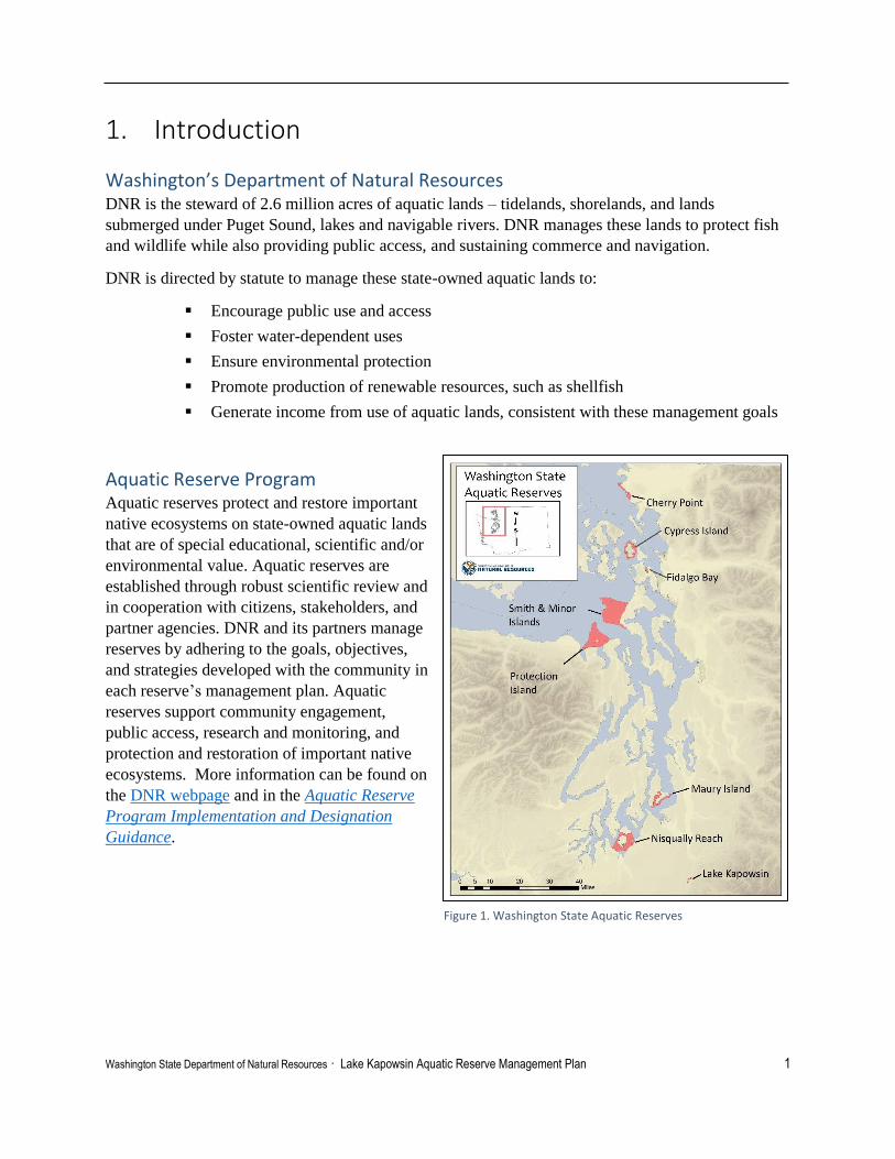
1. Introduction
Washington’s Department of Natural Resources DNR is the steward of 2.6 million acres of aquatic lands – tidelands, shorelands, and lands
submerged under Puget Sound, lakes and navigable rivers. DNR manages these lands to protect fish
and wildlife while also providing public access, and sustaining commerce and navigation.
DNR is directed by statute to manage these state-owned aquatic lands to:
Encourage public use and access
Foster water-dependent uses
Ensure environmental protection
Promote production of renewable resources, such as shellfish
Generate income from use of aquatic lands, consistent with these management goals
Aquatic Reserve Program Aquatic reserves protect and restore important
native ecosystems on state-owned aquatic lands
that are of special educational, scientific and/or
environmental value. Aquatic reserves are
established through robust scientific review and
in cooperation with citizens, stakeholders, and
partner agencies. DNR and its partners manage
reserves by adhering to the goals, objectives,
and strategies developed with the community in
each reserve’s management plan. Aquatic
reserves support community engagement,
public access, research and monitoring, and
protection and restoration of important native
ecosystems. More information can be found on
the DNR webpage and in the Aquatic Reserve
Program Implementation and Designation
Guidance.
Figure 1. Washington State Aquatic Reserves

Washington State Department of Natural Resources · Lake Kapowsin Aquatic Reserve Management Plan 2
Legal Authorities for Establishing State Aquatic Reserves The constitutional authority for proprietary management of state-owned aquatic lands is derived from
Articles XV and XVII of the Washington State Constitution. DNR is directed by the state legislature
in RCW 79.100 through 79.145 to manage the state-owned aquatic lands to provide a balance of
public benefits that include encouraging public use and access, fostering water-dependent use,
ensuring environmental protection, and utilizing renewable resources. In addition, generating revenue
from state-owned aquatic lands when consistent with the other legislatively directed public benefits is
also considered a public benefit.
RCW 79.10.210 authorizes DNR to identify and withdraw limited acreages of public land from
conflicting uses. The purpose of withdrawal is to increase continuity in public land management and
facilitate long range planning. Withdrawn public lands are to be maintained for the benefit of the
public as areas where natural ecological systems can be observed, studied, enjoyed, or otherwise
used.
WAC 332-30-151 directs DNR to consider lands with educational, scientific, or environmental
values for aquatic reserve status, and identifies management guidelines for aquatic reserves. WAC
332-30-106(16) defines environmental reserves as sites of environmental importance, which are
established for the continuance of environmental baseline monitoring and/or areas of historical,
geological, or biological interest requiring special protective management. WAC 332-30-106(14)
defines educational reserves as educationally important areas with aquatic lands typical of selected
habitat types which are suitable for educational projects. WAC 332-30-106(64) defines scientific
reserves as sites important for scientific research projects and/or areas of unusually rich plant and
animal communities suitable for continuing scientific observation.
Lake Kapowsin Aquatic Reserve Description The Lake Kapowsin Aquatic Reserve is established as an environmental reserve to protect important
native ecosystems, to facilitate collaborative partnerships, and to maintain existing uses and
recreational opportunities for current and future generations. The Lake Kapowsin Aquatic Reserve
includes all of the state-owned shorelands and bedlands of Lake Kapowsin, totaling approximately
475 acres (Figure 2). Appendix A provides a more thorough geographic, physical, and biological
description of the Lake Kapowsin Aquatic Reserve. For a complete legal description of the Lake
Kapowsin Aquatic Reserve boundaries please refer to the Commissioner’s Order in Appendix E.

Washington State Department of Natural Resources · Lake Kapowsin Aquatic Reserve Management Plan 3
Figure 2: Lake Kapowsin Aquatic Reserve
Purpose of the Lake Kapowsin Aquatic Reserve Management Plan This management plan describes native species and habitats, ecosystem features, and recreational
uses in the aquatic reserve. The plan reflects the current site conditions, scientific knowledge, and
human uses within the reserve. The conservation targets, desired future conditions, goals and
strategies will guide management of the Lake Kapowsin Aquatic Reserve. The implementation

Washington State Department of Natural Resources · Lake Kapowsin Aquatic Reserve Management Plan 4
guidance describes the role of the Aquatic Reserve Program as facilitator working with partners and
the community toward common goals.
Planning Process DNR completed a lengthy outreach and evaluation
process for the Lake Kapowsin Aquatic Reserve.
The process included outreach to the public, local
community groups, agencies, and Tribal interests.
Two open house public meetings were held in fall
of 2014 to address questions and gather feedback
from the community. An objective scientific
evaluation of the site was completed in the spring of
2015 by a Technical Advisory Committee, a panel
of natural resource experts. The Technical Advisory
Committee unanimously recommended Lake
Kapowsin be designated an aquatic reserve. A
Planning Advisory Committee representing a wide
range of local interests assisted with plan
development. Members of the committee included habitat and fish biologists, county and local
planners, fishermen, recreational users, and local residents. The Planning Advisory Committee met
four times in the fall of 2015 and winter of 2016 to identify monitoring, outreach, and restoration
needs and to direct and review the content of the Lake Kapowsin Management Plan. Three additional
public meetings and workshops were held in April and June 2016 to gather ideas from local residents
about how to build community partnerships and to ensure local voices were part of the management
plan.
Ongoing Review DNR will work with state and local governments, Tribes, hunters, fishers, boaters, area
organizations, adjacent landowners, leaseholders, and local citizens to review the management plan
every 10 years as necessary over its 90-year term. This will ensure the aquatic reserve goals are being
met and that the plan is updated to reflect changes in scientific knowledge, condition of habitats and
species, and human uses of state-owned aquatic lands
Lake Kapowsin Aquatic Reserve Planning Advisory Committee (September 2015, DNR)

Washington State Department of Natural Resources · Lake Kapowsin Aquatic Reserve Management Plan 5
2. Current Uses, Recreation & Stewardship This section describes public and private ownership of lands in and around Lake Kapowsin, current
uses of state-owned aquatic lands, recreational uses, and stewardship activities. The current condition
and uses of Lake Kapowsin provide a baseline picture of the lake that informs the management
guidance.
Uses on state-owned aquatic lands take many forms, including public access sites, utility right-of
ways, overwater structures, restoration projects, and a variety of recreational activities. DNR issues
different types of use authorizations (i.e., rights-of-entry, licenses, leases, and easements) for these
activities. Maintaining appropriate uses within the reserve is a critical component of DNR’s overall
strategy under WAC 332-30-151(2), which states that “leases for activities in conflict with reserve
status shall not be issued.”
Lake Kapowsin is a popular destination for recreational fishing, waterfowl hunting, and boating. The
Aquatic Reserve Program supports current recreational opportunities, public use, and access to state-
owned aquatic lands. The aquatic reserve will protect the unique features of the lake ensuring future
generations can continue to enjoy hunting, fishing, and boating at Lake Kapowsin.
Ownership and Land Use
Aquatic Lands Ownership There are two classifications of aquatic lands within the aquatic reserve area: bedlands and
shorelands. Bedlands are aquatic lands that are submerged at all times and are solely managed by
DNR. Shorelands are located at the shore of freshwater areas between the line of navigability and
permanent upland vegetation or line of mean high water. Approximately 50% of the Lake Kapowsin
shorelands are managed by DNR and 50% are privately-owned (Table 1). Private shoreland owners
include Hancock Timber Resource Group, the Muckleshoot Tribe, the Puyallup Tribe, Tacoma
Water, and others.
Table 1: Lake Kapowsin aquatic land ownership.
Ownership Aquatic land
classification
Acres Percent
State-owned Bedlands 435.03 100
State-owned Shorelands 40.61 49.7
Private Shorelands 41.17 50.3
Upland Ownership The uplands adjacent to Lake Kapowsin shorelands are owned by other public and private entities.
Adjacent upland landowners include Hancock Timber Resource Group, the Puyallup Tribe, the
Muckleshoot Tribe, Tacoma Water, Washington Department of Fish and Wildlife (WDFW) and
other private entities.

Washington State Department of Natural Resources · Lake Kapowsin Aquatic Reserve Management Plan 6
Uplands on the eastern side of the lake are primarily forested areas managed for timber harvest or
other natural resources extraction. Owners include the Hancock Timber Resource Group, the
Puyallup Tribe, Rainier Resources and Rainier Timber.
Hancock Forest Management is steward of the Kapowsin Timberlands Recreational Area east of
Lake Kapowsin. This forested neighboring area spans about 182 square miles and offers fee-based
public recreation opportunities for permitted firewood harvest, hunting, fishing, camping, and
equestrian use. See their website for more information:
www.hancockrecreationnw.com/kapowsin/about/about-kapowsin
The Kapowsin Quarry, located approximately 700 ft. northeast of Lake Kapowsin, is owned by
Rainier Resources LLC and leased to Washington Rock Quarry Inc. Kapowsin Quarry produces
crushed rock, quarry spalls, rip rap, and large armor rock used in shoreline protection.
The Washington Department of Fish and
Wildlife (WDFW) manages the public
access on the northwest side of the lake
and owns the upland parcel with the
parking lot and restroom.
The wetlands located along the north
outlet and south inlet of the lake are
primarily privately-owned.
Tacoma Water, part of Tacoma Public
Utilities, owns several parcels on the
south and west shoreline. The railroad
right-of-way along the west side of the lake is owned by Tacoma Public Works Mountain Division.
Utility – Cable Crossing DNR currently has a right-of-way agreement in perpetuity with Hancock (#51-020341) for a
transmission line. The line crosses Lake Kapowsin starting near the WDFW boat launch, over
Jaybird Island, and to the eastern shore of Lake Kapowsin. The right-of-way is established to include
a buffer to protect the transmission line from potential damage. This is the only encumbrance on
state-owned aquatic lands at Lake Kapowsin.
Overwater Structures There are three docks on Lake Kapowsin; none of them occupy state-owned shorelands. Two of the
three docks are private. The first dock is associated with a private picnic area on the east side of the
lake and the second, near the north end of the lake, is part of a private residence that was formerly a
small resort. The third is the WDFW public dock with boat ramp and parking area. WDFW has a
non-exclusive easement with the City of Tacoma for the adjacent second-class shorelands where
the public dock and boat launch are located. The WDFW public access area is used for a variety
of uses including fishing, hunting, bird watching, and other recreational boating activities.
WDFW boat ramp and dock at Lake Kapowsin (August 2014, DNR)

Washington State Department of Natural Resources · Lake Kapowsin Aquatic Reserve Management Plan 7
Remnant pilings from docks and overwater structures that supported historical logging and timber
mills are present at the south end of the lake and west of the WDFW public access boat ramp.
Recreational Uses The natural character of Lake Kapowsin, the habitat provided by its submerged forest, and the
WDFW public access make the lake a desirable spot for sport fishing, waterfowl hunting,
birdwatching, photography, and boating. Fishing and hunting are both managed by the Washington
Department of Fish and Wildlife and designation as an aquatic reserve does not affect fishing or
hunting rules at Lake Kapowsin.
Boating Non-motorized watercraft, boats with electric trolling motors, and low-speed gas-powered motors are
favored by recreational users. The remnant stumps and woody debris naturally limit the speed and
size of watercraft used on the lake. Water skis are not allowed on Lake Kapowsin and vessel speed is
limited to five miles per hour per the Pierce County Code (8.88.460.B.3.a).
Fishing Lake Kapowsin is a popular fishing
location and receives relatively high
fishing pressure. Lake Kapowsin is open to
fishing year-round and is managed by
WDFW as a mixed-species water (Jackson
and Caromile 2000). The lake has been
stocked regularly since the 1960s with
legal-sized Rainbow Trout. In 2015, almost
30,000 Rainbow Trout were planted
between March and May (WDFW 2015a).
Warmwater fish species, including
Largemouth Bass, Black Crappie, Yellow
Perch, Pumpkinseed Sunfish, and Rock
Bass, are the primary targets for anglers
(Jackson and Caromile 2000).
WDFW conducted a recreational fishing survey in 2008 to assess fishing use at the lake. There were
an estimated 12,330 shore angler trips and 11,094 boat angler trips (5,604 boats) between January
and December. The majority of fishing activity took place between May and October during the
summer season (S. Caromile, WDFW, personal communication, 2015).
Hunting Waterfowl hunting is another popular activity at Lake Kapowsin and the entire lake is open to
waterfowl hunting (M. Tirhi, WDFW, personal communication, 2015). Public meeting attendees
indicated that Lake Kapowsin is one of the few lakes open for hunting in Pierce County with a public
access. The fringing wetlands and abundant large woody debris provide nesting duck habitat. WDFW
manages waterfowl hunting and regulations can be found on the WDFW website.
Fishing and boating at Lake Kapowsin (April 2016, DNR)
Washington State Department of Natural Resources · Lake Kapowsin Aquatic Reserve Management Plan 8
Stewardship
Clean Shorelines Scattered littering and concentrated trash dumping are evident along the shoreline of Lake Kapowsin.
In a survey of 20 wetland and physical habitat sites in the summer of 2015, trash was observed at
40% of the sites (Hamer Environmental 2015). Small debris, such as wrappers, cans, bottles, and
plastic bags, were most common, but large debris such as tires and an abandoned car were also
present (Hamer Environmental 2015; DNR staff observation).
Trash dumping is an ongoing problem around Lake Kapowsin and occurs on both private and public
lands. Concentrated dumping of large debris are especially problematic in areas accessible by car and
are most apparent near Orville Road East and areas west of the public access boat launch. Smaller
items, such as cans, bottles and Styrofoam bait containers, are found in shallow water and lodged in
driftwood and vegetation along the lakeshore.
Trash dumping, vandalism, and theft at the public boat launch and surrounding areas were the most
common issues of concern expressed by the community at a series of Open House meetings in 2014.
Meeting attendees also expressed concern over the unauthorized use of quads and off-road vehicles
on private lands around the lake. Attendees reported that quads have damaged No Name Creek, a
creek which may have previously supported Coho Salmon. Efforts have been made by the property
owner to block access to these areas.
Other observations of human influence include dispersed trails to the lakeshore, unofficial campsites,
and a hunting blind (Hamer Environmental 2015).
Habitat Restoration and Enhancement
Several habitat restoration and enhancement projects have taken place at Lake Kapowsin. WDFW
has completed restoration work that involved invasive species control and native vegetation plantings
to mitigate impacts of the public boat launch developed in 2008. Native shrubs, such as ninebark and
twinberry, were planted east of the boat launch, and are now well established along the shoreline.
Landscape fabric was used to suppress weeds around native plants and prevent erosion.
In the spring of 2015, DNR hosted a community cleanup that involved 17 people who removed an
estimated 15 bags of trash from the shores east and west of the boat launch. Invasive blackberries,
hawthorn, and Scotch broom were also removed during this event. The Muckleshoot Tribe Public
Works Department also conducted a cleanup on tribal property west of the boat launch that same
week.
References Hamer Environmental L.P. 2015. Lake Kapowsin Biological Inventory, Final Report. Prepared for
Washington Department of Natural Resources, Aquatic Reserves Program.
Jackson, C. and S.J. Caromile. 2000. An Assessment of the Warmwater Fish Community in
Kapowsin Lake (Pierce County), Sept. 1999. WDFW Fish Program, Warmwater Enhancement
Program. Olympia (WA).

Washington State Department of Natural Resources · Lake Kapowsin Aquatic Reserve Management Plan 9
[WDFW] Washington Department of Fish and Wildlife. 2015. Catchable trout plant reports
[internet]. Olympia (WA): WDFW Fish Program; Accessed 18 August 2015.
http://wdfw.wa.gov/fishing/plants/weekly/search.php?searchby=County&search=Pierce&orderby
=LakeStocked%20ASC,%20StockDate%20DESC.

Washington State Department of Natural Resources · Lake Kapowsin Aquatic Reserve Management Plan 10
3. Conservation Targets Conservation targets are important native habitats, species, and unique features identified to maintain
biological diversity and ecological function within the reserve. The conservation targets support the
aesthetic and recreational value of the natural setting of Lake Kapowsin. These conservation targets
were recommended by the Technical Advisory Committee and refined by the Planning Advisory
Committee. Management strategies were developed to meet the protection and conservation needs of
these priority species and habitats.
Refer to Appendix A for a full description of the natural environment. Appendix C contains a
comprehensive observed species list and WDFW Priority Species and Habitats list.
Geophysical characteristics & Habitats
a) Geologic origins related to damming of Kapowsin Creek by the Electron Mudflow
Lake Kapowsin was formed by the Electron mudflow approximately 500 years ago.
Originating on the west slopes of Mount Rainier, the Electron mudflow streamed down
the Puyallup Valley and up Kapowsin Creek, damming the creek at a narrow constriction
of the valley. The dense, mature forest that occupied the valley was flooded, resulting in a
drowned forest with massive stumps that reach to or near the lake’s surface and are still
embedded in the lake bottom today. These ancient submerged stumps, along with
abundant floating logs, large wetland habitat areas, and natural forested shorelines
provide diverse habitat areas for numerous species (Crandall 1963).
Lahar-formed lakes and drowned forests are extremely rare in the Puget Lowland region.
These features highlight a unique geologic history and link to the landscape-forming
legacy of Mount Rainier. The preserved “sub-fossil” trees present excellent opportunities
for education and research. In addition, Lake Kapowsin is situated on the divide between
the Puget Lowland and Cascade physiographic regions. The forested terraces to the east
of the lake were created by the rapid retreat of the Vashon ice flow and are characteristic
of eastern glacial margins in the Pacific Northwest (Walsh and Logan 2007). The glacial
terraces and drowned forest are easily accessible and visible to visitors and provide a
distinctive perspective of the dynamic geological forces that created the regional
landscape geologic.
b) Tree stumps, drowned subfossil forest, and large woody debris
Large woody debris (LWD) and structure is a key physical element of the Lake
Kapowsin environment. Submerged and emergent tree stumps, remnants of the mature
drowned forest, are still scattered throughout the lake. Fallen trees, a large floating log
raft area at the north outlet, and small log assemblies along the lake shore also contribute
to the fringing wetlands and complex habitat structure.
The ancient submerged stumps, abundant floating logs, and woody structure are the basis
for the form and ecological function of the lake and create complex physical habitat for
fishes, amphibians, and invertebrates. The tops of subsurface stumps create pockets of
shallow water habitat in deeper, open water areas that are used by warmwater fish for
spawning. Emergent stumps create additional midwater structure that birds use for
nesting and foraging. The floating log rafts and other large woody debris stabilize

Washington State Department of Natural Resources · Lake Kapowsin Aquatic Reserve Management Plan 11
shoreline areas, reduce water flow, and trap sediments, nutrient and leaf litter. They also
increase available habitat for insect production and create small protected backwater
areas that offer refuge and suitable structure for amphibian egg masses. The structural
diversity created by LWD is essential to many aquatic species for refuge (hiding),
overwintering habitat, and juvenile rearing (Maser et al. 1988; Collins and Montgomery
2002; Montgomery et al. 2003a; Montgomery et al. 2003b; Knutson and Naef 1997).
c) Large, undisturbed wetlands at lake inlet and outlet, fringing shoreline wetlands, and
floating log habitat
Several types of wetland
communities are associated with
the Lake Kapowsin ecosystem. A
large, forest and shrub wetland
complex persists along Kapowsin
Creek just north of the lake. This
wetland system extends southerly
along the lake shore including a
well-vegetated riparian area, then
merges with the large floating log
habitat complex. A large diverse
wetland assemblage emerges out
of the south margin of the lake.
This wetland community
transitions from a unique exposed flats area with emergent wetland plants, to a large
shrub-covered wetland area, then grades into a deciduous forested wetland. The extensive
transitional zone provides sheltered nursery grounds and migratory passage for several
species, including salmonids heading to their upstream spawning habitat. There are also
23 lake-fringe wetland areas that comprise 48 percent of the shoreline (Hamer
Environmental 2015).
Wetlands are known to play a vital role in the landscape through hydrologic functions
related to maintaining the water regime and quality in a watershed. They do this by
intercepting surface flow, retaining water, sediment, and processing nutrients, reducing
flooding, and potentially minimizing drought. Wetlands also provide habitat connectivity
from upland regions and stream corridors to the open lake area. A host of fish and
wildlife species, including waterfowl, warmwater fishes, sensitive salmon species,
amphibians and other wetland-dependent wildlife use these habitat areas (Granger et al.
2005).
d) Contiguous and relatively intact lake habitat, state-owned aquatic shorelines, and shallow
nearshore habitat
The shorelines of Lake Kapowsin are relatively undeveloped compared to other Puget
Lowland lakes in the region. The tranquil and intact shoreline supports the potential of a
healthier, integrated, lake ecosystem. The nearshore area captures much of the sediments,
wrack and plant parts washing in from the watershed. Both aquatic and wetland plants in
the nearshore, provide habitat for diverse species. These aquatic plants provide substrate
Wetlands complex at the south end of Lake Kapowsin (August 2014, DNR)

Washington State Department of Natural Resources · Lake Kapowsin Aquatic Reserve Management Plan 12
for algae and other epiphytes, insects, crustaceans, and fishes that use this area for
breeding, cover and foraging.
The extensive area of forest lands, along with wetlands bordering both ends of the lake,
establishes broad habitat connectivity, supports critical ecological services and a more
balanced, functioning ecosystem. Breeding, feeding, nesting, migration and rearing
habitat for vertebrate and invertebrate grazers and seed eaters, omnivores, carnivores, and
scavengers exist throughout the area (Kruckeberg 1991).
Fish & Wildlife
a) Salmonid species and habitats, including Chinook Salmon, Coho Salmon, Cutthroat Trout,
and steelhead
The lake supports Coho Salmon and Cutthroat Trout, which move through the lake, and
occasional Steelhead (B. Smith, Puyallup Tribe, personal communication, 2015; Jackson
and Caromile 2000). Chinook Salmon, Pink Salmon, Coho Salmon, steelhead and
occasionally Chum Salmon are found in Kapowsin Creek (Marks et.al. 2013).
Coho Salmon travel through the lake into upper Ohop Creek to spawn. Upper Ohop
Creek is technically considered the continuation of Kapowsin Creek and is the main
feeder stream to Lake Kapowsin. Because young Coho Salmon often remain in
freshwater for up to two years before making their way to the ocean, the lake provides
dependable rearing and migratory opportunity. The lake also may attract Coho Salmon
fingerlings from other portions of the upper and mid-Puyallup basin, as sizeable good
quality winter rearing habitat is not very accessible in the mid basin area (B. Smith,
Puyallup Tribe, personal communication, 2015)
b) Amphibian species, including Northwestern salamander, Northern red-legged frog,
rough-skinned newt, Pacific tree frog, and Western toad, and associated habitats
The presence of four native amphibian
species have been confirmed at Lake
Kapowsin: Pacific tree frog, Northern
red-legged frog, Northwestern
salamander, and rough-skinned newt
(DNR 2015; Hamer Environmental
2015). In addition, Western toad, Oregon
spotted frog, and two other salamander
species are predicted to inhabit the Pierce
County Biodiversity Management Area 8,
which is located four miles west of Lake
Kapowsin and has similar habitat (Brooks
et al. 2004).
The Northern red-legged frog is listed as a federal species of concern, but has no state
listing. The Oregon spotted frog is listed as a Washington state endangered species and a
Northwestern salamander egg mass (March 2015, DNR)

Washington State Department of Natural Resources · Lake Kapowsin Aquatic Reserve Management Plan 13
federal threatened species. The Western toad is a state candidate species and listed as a
federal species of concern (WDFW 2008).
c) Migratory waterfowl and raptors, including nesting Bald Eagles and Osprey, and Purple
Martins
Lake Kapowsin hosts a diverse number of
bird species throughout the year as there is
essential nesting, rearing and foraging
habitat for both resident and migratory
birds. The lake is designated as a WDFW
Waterfowl Concentration area and six
species of state or federal concern have
been identified: Bald Eagle, Great Blue
Heron, Osprey, Pileated Woodpecker,
Purple Martin, and Wood Duck (WDFW
waterfowl counts; Hamer Environmental
2015; eBird).
Osprey at Lake Kapowsin (DNR)

Washington State Department of Natural Resources · Lake Kapowsin Aquatic Reserve Management Plan 14
References
Brooks, K., K.M. Dvornich, M. Tirhi, E. Neatherlin, M. McCalmon, and J. Jacobson. 2004. Pierce
County Biodiversity Network Assessment: August, 2004. Report to Pierce County Council, Pierce County, 146 pp.
Collins, B.D. and D.R. Montgomery. 2002. Forest Development, Wood Jams, and Restoration of
Floodplain Rivers in the Puget Lowland, Washington. Restoration Ecology, v. 10, n. 2, p. 237-247.
Crandell, D.R. 1963. Surficial geology and geomorphology of the Lake Tapps Quadrangle,
Washington. Geological Survey Professional Paper 388-A. US Geological Survey Publications.
Accesses Feb. 16, 2015. Available at http://pubs/pp/pp/pp388A
Granger, T., T. Hruby, A. McMillan, D. Peters, J. Rubey, D. Sheldon, S. Stanley, E. Stockdale. April
2005. Wetlands in Washington State - Volume 2: Guidance for Protecting and Managing
Wetlands. Washington State Department of Ecology. Publication #05-06-008. Olympia, WA.
Hamer Environmental L.P. 2015. Lake Kapowsin Biological Inventory, Final Report. Prepared for Washington Department of Natural Resources, Aquatic Reserves Program. 30 June 2015.
Kruckeberg, A.R. 1991. The Natural History of Puget Sound Country. University of Washington Press, Seattle.
Knutson, K. L., and V. L. Naef. 1997. Management recommendations for Washington’s priority
habitats: riparian. Wash. Dept. Fish and Wildlife, Olympia. 181pp.
Marks, E.L., R.C. Ladley, B.E. Smith, A.G. Berger, J.A. Paul, T.G. Sebastian, and K.W. Williamson.
2013. 2012-2013 Annual salmon, steelhead, and bull trout report: Puyallup/White River Watershed- Water resource Inventory Area 10. Puyallup Tribal Fisheries, Puyallup, WA.
Maser, C., R. F. Tarrant, J. M. Trappe, and J. F. Franklin (eds.). 1988. From the forest to the sea: a
story of fallen trees. General Technical Report PNW-GTR-229. Portland, OR: USDA Forest
Service. pp 153
Montgomery, D.R., S. Bolton, D.B. Booth, and L. Wall (eds). 2003a. Restoration of Puget Sound
Rivers. Center for Watershed and Streamside Studies, Seattle, WA: University of Washington Press.
Montgomery, D.R., T.M. Massong and S.C.S. Hawley. 2003b. Debris flows, log jams, and the
formation of pools and alluvial channel reaches in the Oregon Coast Range: Geological Society of America Bulletin, v. 115, p. 78–88
Walsh, Timothy J. and Logan, Robert L., 2007, Extending and expanding the stratigraphy of the
southern Puget Lowland [abstract]: Geological Society of America Abstracts with Programs, v. 39, no. 4, p. 12.

Washington State Department of Natural Resources · Lake Kapowsin Aquatic Reserve Management Plan 15
[WDFW] Washington Department of Fish and Wildlife. 2008. Priority Habitat and Species List. Olympia, Washington. 177 pp.

Washington State Department of Natural Resources · Lake Kapowsin Aquatic Reserve Management Plan 16
4. Management Guidance The Lake Kapowsin Aquatic Reserve is established as an environmental reserve to protect important
native ecosystems, to facilitate collaborative partnerships, and to maintain existing uses and
recreational opportunities for current and future generations. This section of the plan outlines the
desired future conditions of the lake and the goals and objectives intended to achieve these
conditions. The management guidance was developed collaboratively with the Lake Kapowsin
Planning Advisory Committee.
Desired Future Conditions Desired Future Conditions describe the overall target, or ideal, conditions through the 90-year term
of the aquatic reserve. They provide guidance for developing the management goals and objectives.
a) Public Access and Recreation
Throughout the 90-year term of the reserve public access and recreation will be fostered.
The aquatic reserve will protect important aquatic habitats used by fish and waterfowl
ensuring that future generations can continue to enjoy hunting, fishing, and boating at
Lake Kapowsin. Recreational areas, such as trails and picnic areas, will enhance
community stewardship and public access to the lake. Community support, involvement,
and stewardship of the reserve will result in clean shorelines and a safe and secure public
access area. Education and outreach, including interpretive signs, will increase public
appreciation for Lake Kapowsin and the unique geology, habitats, history, and cultural
resources of the lake.
b) Resource Protection and Restoration Natural processes, lake and shoreline habitats will be kept intact. The submerged ancient
forest stumps and the floating logjam at the northern outlet will continue to provide
complex structural habitat for birds, fish, and amphibians. Aquatic vegetation fringing the
shorelines and large wetlands at the inlet and outlet will be maintained as functioning,
high quality habitat that supports thriving amphibian and invertebrate communities.
Native plant species will predominate in nearshore and aquatic habitats. Important habitat
areas where birds feed, breed, and overwinter will be protected, and diverse migratory
bird and waterfowl populations will continue to use the lake. The recreational fishery for
trout and warmwater fish will be sustained. Salmon migration and habitat areas will be
maintained and enhanced.
c) Monitoring and research A strong program of monitoring and research will provide a greater understanding of
species diversity, wildlife and fish communities, habitat use, and human impacts at Lake
Kapowsin. Baseline knowledge and continued monitoring will guide adaptive
management practices. Information will be broadly shared with partners, stakeholders,
and the community.
Washington State Department of Natural Resources · Lake Kapowsin Aquatic Reserve Management Plan 17
d) Partnerships and community engagement In the future, strong partnerships with adjacent landowners, community organizations,
local government, and other natural resource managers will be cultivated to support a
broad watershed strategy for the Lake Kapowsin area. The partners will work
cooperatively to implement best management practices that reduce upland impacts and
maintain water quality.
Goals The following management goals have been established for the Lake Kapowsin Aquatic Reserve:
1) Public access and recreation: Promote public access, encourage sustainable recreation,
and support continued fishing and hunting opportunities.
2) Resource protection and restoration: Protect, enhance and restore the integrity of
natural processes and habitats for the benefit of native plants and wildlife.
3) Monitoring and research: Gather and assess ecological and human-use information to
inform and support management.
4) Partnerships and community engagement: Promote stewardship of aquatic habitats
and species by developing partnerships with adjacent landowners, Tribes, non-profit
organizations, local government, agencies, resource managers, the local community and
regular recreational users.
5) Use authorizations on state-owned aquatic lands: Ensure uses authorized on state-
owned aquatic lands in the reserve are consistent with the desired future conditions.

Washington State Department of Natural Resources · Lake Kapowsin Aquatic Reserve Management Plan 18
Objectives and Strategies
Goal 1: Public Access & Recreation Promote public access, encourage sustainable recreation, and support continued fishing and hunting
opportunities.
Objectives 1.1: Hunting, fishing, and public access – Foster public access, sustainable recreational use, fishing,
and hunting on state-owned aquatic lands within and adjacent to the reserve
Strategies
a) Work with WDFW, Pierce County and the Graham/Kapowsin community to support
boating, hiking, picnicking, fishing, and hunting users
b) Support the 2006 Graham Community Plan to establish an upland park adjacent to Lake
Kapowsin, the development of a community wide trail system, open space corridor and
associated recreational activities
c) Post signs or fliers at the public access area educating users about recreational
opportunities and boating hazards
d) Sponsor family-oriented events at the lake, such as kids fishing days, to encourage
recreation and stewardship
e) Promote the unique history, geology and ecology of Lake Kapowsin, working with local
historians, geologists, Tribes, local organizations and WDFW to develop interpretive
signs, public stewardship, and educational opportunities
f) Facilitate public access, which could include a private boat rental facility (in the past the
lake supported a facility that rented small boats.)
1.2: Safe public access – Increase safety and security at the WDFW public boat launch
Strategies
a) Foster conservation ethic that supports the aquatic reserve and recreational opportunities
to prevent theft and vandalism at public access areas
b) Work with partners and community to increase law enforcement or site steward presence
at the WDFW public access and surrounding areas
c) Coordinate with WDFW, adjacent property owners, and the community to develop
additional strategies to reduce theft and vandalism at the WDFW public boat launch
1.3: Clean shorelines – Encourage clean shorelines and reduce trash dumping around the lake
Strategies
a) Raise awareness of the aquatic reserve and the impacts of trash dumping through
outreach and educational materials and signs

Washington State Department of Natural Resources · Lake Kapowsin Aquatic Reserve Management Plan 19
b) Sponsor, encourage, and participate in community clean-ups events
c) Coordinate with adjacent land owners to help reduce trash dumping
Goal 2: Resource Protection & Restoration Protect, enhance and restore the integrity of natural processes and habitats for the benefit of native
plants and wildlife.
Objectives 2.1: Native habitat areas – Protect and enhance important habitat areas including wetlands, floating
log mats, submerged tree stumps, nearshore and riparian areas
Strategies
a) Protect habitat areas that support native amphibian, waterfowl and migratory bird,
wildlife, and macroinvertebrate communities
b) Preserve native plant communities and wetland areas
c) Maintain large woody structural habitat, including submerged stumps and floating logs
d) Sustain existing areas of natural shoreline and riparian vegetation
e) Encourage partnerships with adjacent landowners for important habitat areas (such as
wetlands)
2.2: Fish habitat – Protect fish spawning, rearing habitat, and movement corridors
Strategies
a) Maintain submerged logs and stumps for warmwater fish spawning and adult habitat
b) Maintain nearshore area substrate and riparian areas to support migratory corridors,
spawning structure, rearing areas, and refugia
c) Incorporate a collaborative watershed approach to fish habitat protection to ensure
benefits extend to adjacent salmon-bearing streams
d) Coordinate with adjacent landowners and resource managers to maintain the integrity of
fish habitat in Lake Kapowsin drainage, including “No Name Creek” and Kapowsin
Creek
2.3: Restoration – Restore and enhance degraded or impaired native habitat areas and lacustrine
(lake) processes to better functioning conditions
Strategies
a) Work with partners to identify restoration needs within the reserve and prioritize projects
b) Develop partnerships to seek funding for restoration implementation and completion
c) Work with cooperating landowners on nearshore restoration proposals and replant
shoreline areas where possible

Washington State Department of Natural Resources · Lake Kapowsin Aquatic Reserve Management Plan 20
d) Coordinate with upland landowners to incorporate adjacent wetlands and tributaries in
restoration planning (such as “No Name Creek”, Kapowsin Creek and Ohop Creek, refer
to Appendix D for location)
e) Survey for invasive species annually and control invasive plants using integrated pest
management strategies that reduce need for chemical control. Use only aquatic approved
herbicides in limited amounts.
f) Develop management control strategy for bullfrogs
2.4: Water quality - Promote and support collaborations focused on improving water quality that
reduce impacts to fish, aquatic vegetation and other sensitive species
Strategies
a) Inventory stormwater inputs and identify improved management strategies
b) Collaborate with cooperating landowners and land managers to improve shoreline
conditions and minimize potential erosion and pollution sources
c) Build strong conservation partnerships to support a broad watershed approach (refer to
objective 4.5)
d) Avoid authorizing new uses that could negatively affect water quality and ensure lessees
follow habitat stewardship measures (refer to Goal 5)
Goal 3: Monitoring & Research Gather and assess ecological and human-use information to inform and support management.
Objectives 3.1: Baseline inventories & trend monitoring – Conduct, facilitate, and support inventory and
monitoring programs to guide management
Strategies
a) Collaborate with partners and local organizations to increase inventory and monitoring
surveys of conservation targets (wetland habitats, native plants, amphibians,
invertebrates, lacustrine processes, and fish)
b) Develop comprehensive monitoring plan with established survey sites
c) Continue year-round water quality monitoring and use monitoring results to inform lake
management strategies
d) Determine presence/absence of Oregon spotted frog, Western pond turtle, Western Toad,
and Pacific shrew
e) Work with partners to understand species habitat usage
f) Continue to inventory aquatic/emergent plant communities with an emphasis on
documenting the presence of rare plants and plant communities, such as identifying Class
I wetland areas and verifying bog community
Washington State Department of Natural Resources · Lake Kapowsin Aquatic Reserve Management Plan 21
3.2: Data organization and evaluation – Compile and share data to inform and support
management
Strategies
a) Coordinate with partners to inventory data and identify gaps
b) Coordinate monitoring and research efforts with local and state agencies, local non-
profits, universities and citizen science groups
c) Develop a process for sharing data and research with partners, scientists and community
through online resources, outreach materials, and signage
d) Review and evaluate scientific and management information regularly to guide research,
monitoring, protection and restoration decisions
3.3: Research – Promote and support research within the reserve
Strategies
a) Catalog historical and existing studies and use information from monitoring activities to
shape and inform research projects
b) Support research that investigates native salmonid and non-native warmwater fish species
interactions
c) Support research projects that focus on conservation targets, human-use influences,
habitat usage, and geologic history
d) Support or partner to research hydrologic budget and nutrient sources
Goal 4: Partnerships & Community engagement Promote stewardship of aquatic habitats and species by developing partnerships with adjacent
landowners, Tribes, non-profit organizations, local government, agencies, resource managers, the
local community and regular recreational users.
Objectives 4.1: Partnerships - Develop partnerships to increase the Aquatic Reserve Program’s outreach,
monitoring & research, and restoration capacity
Strategies
a) Work cooperatively with partners to develop outreach and education materials
b) Collaborate with partners to identify and fund potential enhancement and restoration
activities that will support the management goals of the aquatic reserve
c) Collaborate with local universities and colleges to strengthen links to limnology, wetland
programs, and potential research thesis topics
d) Maintain strong relationships with tribal governments and staff at all levels of DNR
management regarding Lake Kapowsin

Washington State Department of Natural Resources · Lake Kapowsin Aquatic Reserve Management Plan 22
e) Establish a partner and/or citizen stewardship group that guides and implements the
management plan in conjunction with the reserve program
4.2: Education and outreach – Increase public knowledge of the aquatic reserve, natural
environment, local history, and cultural context
Strategies
a) Develop interpretive signs and install reserve identifier signs in conjunction with WDFW
and stewardship groups
b) Provide information on the history, geology, and ecology of the Lake Kapowsin area on
the DNR website
c) Work with stewardship group and other partners to develop outreach and education
programs
d) Incorporate historical and geological context in outreach materials
4.3: Community stewardship – Increase voluntary stewardship by reserve users and adjacent
landowners through community engagement
Strategies
a) Promote community interest in the reserve and public access through outreach materials,
signs, and an annual appreciation event or festival
b) Provide information on best practices and voluntary stewardship to adjacent property
owners and recreational users
c) Partner with local organizations to provide education about upland impacts on lakes and
water quality (i.e. importance of riparian vegetation buffers, the impacts of invasive
species, impervious surfaces, and stormwater runoff)
d) Work with community and partners, such as Northwest Trek, to strengthen the local
citizen science network
e) Work with cooperating adjacent landowners to support opportunities for compatible
management and restoration
4.4: Watershed management strategy- Coordinate with existing area organizations, such as
Puyallup Watershed Council, to incorporate Lake Kapowsin in a larger watershed management
strategy
Strategies
a) Encourage conservation partnerships that focus on protecting water quality, tributary, and
shoreland condition
b) Work with watershed management groups in the mid-upper Puyallup basin that restore
and monitor conditions in the basin

Washington State Department of Natural Resources · Lake Kapowsin Aquatic Reserve Management Plan 23
Goal 5: Use Authorizations on State-Owned Aquatic Lands Ensure uses authorized on state-owned aquatic lands in the reserve are consistent with the desired
future conditions.
Objectives 5.1 Use Authorizations on State-Owned Aquatic Lands (does not include privately owned aquatic
lands) - Evaluate use reauthorizations and proposed uses to ensure uses authorized on state-owned
aquatic lands within the reserve are consistent with the goals and objectives of the reserve and
support the desired future conditions
Strategies
a) Perform a critical review of new use proposals pursuant to WAC 332-30-151. DNR will
make determinations about the consistency with the management plan of proposed uses
prior to granting a use authorization
b) DNR will use existing knowledge and science and work with other resource management
authorities to identify regulatory and proprietary actions necessary to protect resources
c) New project proponents must clearly demonstrate and document consistency with the
purpose of the reserve, the goals and objectives, and strategies
d) New use proponents, where potential impacts to ecosystem processes have not been
documented in peer reviewed literature, must review the best available science for the
type and scale of use, associated impacts and present their findings to DNR
e) DNR will consider the following when evaluating re-applications from existing
authorizations and to determine consistency with this plan:
Is the authorization in compliance with conditions of federal, state and local laws
and permits?
Is the authorization in good financial and contractual standing with DNR?
Is the use managed in accordance with and consistent with the goals of this plan?
5.2: Habitat stewardship measures - Ensure uses on state-owned aquatic land are consistent with
current and future DNR Aquatic Habitat Stewardship Measures
Strategies
a) Apply habitat stewardship measures to all land-use authorizations on state-owned aquatic
land
b) Work with tenants or lessees to ensure any significant proposed changes incorporate
current habitat stewardship measures
c) Work collaboratively with tenants or lessees to encourage voluntary best management
practices that reduce impacts to habitats and species
5.3: Unauthorized use – Reduce potential impacts of unauthorized uses and overwater and in-water
structures
Washington State Department of Natural Resources · Lake Kapowsin Aquatic Reserve Management Plan 24
Strategies
a) Determine the possible impacts of unauthorized structures to habitats and species,
whether the use is appropriate for state-owned aquatic lands, and whether it meets the
reserve’s objectives
b) Unauthorized structures that are not able to meet local and state permit terms, are not an
appropriate use of state-owned aquatic lands, or are not consistent with the reserve’s
objectives, will not be authorized and must be removed by the owner. DNR may remove
the unauthorized use when the owner cannot be identified and funding sources are
available
Washington State Department of Natural Resources · Lake Kapowsin Aquatic Reserve Management Plan 25
5. Implementation Guidance
Collaborative Partnerships Successful management of the Lake Kapowsin Aquatic Reserve requires collaborative partnerships
with adjacent landowners, Tribes, non-profit organizations, local government, agencies, resource
managers, the local community and regular recreational users. DNR develops local partnerships to
implement the reserve management strategy and coordinate stewardship efforts. DNR may choose to
work directly with existing non-profit organizations or watershed groups to maximize project
capacity and link Lake Kapowsin Aquatic Reserve management to the larger landscape context.
Cooperative implementation of the Lake Kapowsin Aquatic Reserve Management Plan will require:
A collaborative evaluation of restoration, research, monitoring, and educational needs.
Support from partners, stakeholders, and community.
Consideration of potential funding sources for project implementation.
A review and evaluation of scientific and management information to guide future
development, restoration and protection decisions.
DNR will seek to include a broad spectrum of input from stakeholders and the community during
implementation planning and stewardship project development, including:
■ Community members ■ Tribal government
■ Recreationists, hunters and fishermen ■ Scientific community
■ Adjacent landowners ■ Environmental non-profits
■ Educational organizations ■ Local businesses
■ Local, county & state representatives ■ Graham Advisory Commission
Management decisions are not required to be made based on consensus, however, community and
stakeholder input will be considered in the prioritization of management actions.
Site Stewardship Site stewardship is essential to meet the goals of Aquatic Reserves management. The preceding plan
points to this need, and this section will elaborate on examples of possible projects that site stewards
can lead in order to benefit the Lake Kapowsin Aquatic Reserve.
Community and regional level stewardship could be fostered through annual events that highlight the
natural and historic features of the site, such as “Kapowsin Appreciation Day.” This would follow
the model of many highly successful events such as the Nisqually Watershed Festival, Maury Island
Low Tide Festival, Cherry Point “What’s the Point?” celebration, and Fidalgo Bay Day. These fun
events connect families and communities to the citizen stewards, experts, and reserve staff and build
stronger knowledge and appreciation for special and unique sites, natural science and history.

Washington State Department of Natural Resources · Lake Kapowsin Aquatic Reserve Management Plan 26
Local students could carry out science projects and cleanup work parties at the lake in conjunction
with site stewards. Education grants could support student field trips and utilize water quality
curriculum to foster greater understanding of lake science.
Coordination among site users could lead to organized fishing events and increased stewardship of
the public access area. Individual or paired site stewards could help monitor the site and report illegal
activity to law enforcement. The Aquatic Reserves Program (or WDFW) can support volunteers by
providing training and signing them up as agency volunteers. Programs like this can lead to an
effective citizen work group and self-sustaining and self-organized groups that work on behalf of the
site. For example, Citizen Stewardship Committees for Aquatic Reserves in Puget Sound provide an
excellent model of successful citizen stewardship. Local organizations, such as Northwest Trek, train
and lead citizen science and monitoring projects that could support the collection of water quality and
amphibian data at the lake. The local Audubon chapter could provide volunteers for bird surveys to
monitor both raptors and wintering migrants. Wetland studies and advanced lake studies (limnology)
could be supported by faculty from local universities and colleges.
In conclusion, collaborative partnerships are vital to the reserve management and strategy
implementation. Excellent stewardship and management of a reserve stems from a close working
relationship with the community, stakeholders, agencies, Tribes and non-profits. The work of
program staff can be matched and multiplied through volunteer organizations, grants, and local
partner organizations. High quality monitoring and research data can be developed with the support
of university and college faculty that use and support the reserve. All these efforts lead to synergy
among project partners and positive outcomes for both the site and the community that surrounds it.

Washington State Department of Natural Resources · Lake Kapowsin Aquatic Reserve Management Plan 27
Appendix A – Natural Environment
Appendix A – Table of Contents
1. Introduction…………………………………………………………………… 28
2. Geographic Context ………………………………………………………….. 28
Climate…………………………………………………………………… 28
3. Geomorphic Development……………………………………........................ 29
4. Ecosystem Description……………………………………….......................... 29
5. Ecosystem Processes………………………………………............................. 30
Hydrologic cycle……………………………………………..................... 30
Surface hydrology………………………………………………………... 31
Kapowsin Creek……………………………………………..................... 32
Sediment and upland road management…………………………………. 32
6. Water Quality and Chemistry…………………………………...................... 34
Temperature and dissolved oxygen……………………………………… 35
Water clarity……………………………………………………………... 37
Specific conductance and pH……………………………………………. 38
Nutrients…………………………………………………………………. 39
Trophic State Index……………………………………………………… 40
7. Physical Habitat………………………………………………....................... 41
Drowned subfossil forest………………………………………………... 41
Wetland habitat areas…………………………………………………… 43
Littoral areas…………………………………………………………….. 45
Riparian habitat areas………………………………………………….... 45
Upland habitat areas…………………………………………………….. 46
Noxious weeds………………………………………………………….. 47
8. Fish and Wildlife Resources………………………………………………... 48
Fish…………………………………………………………………….. 48
Birds……………………………………………………………………. 52
Amphibians…………………………………………………………….. 53
Benthic macroinvertebrates……………………………………………. 55
Mammals…………………………………………………..................... 56
Non-native fauna…………………………………………..................... 56

Washington State Department of Natural Resources · Lake Kapowsin Aquatic Reserve Management Plan 28
1. Introduction The following section summarizes the physical and biological characteristics in and adjacent to the
reserve, including physical processes, habitat areas, species, sediment, and water quality. A baseline
for existing conditions is developed by characterizing local ecosystem processes, and how they
contribute to lake ecology, shoreline functions, and the species that inhabit the area. Along with the
social and historical context of the lake area, these components provide a basis to assess the values of
the shoreline and lake resources. This process also refines conservation targets, highlights
opportunities for ecological restoration, identifies data gaps, and guides aquatic land management
actions that sustain and improve the lake resources.
Natural resource descriptions have benefited from a Biological Assessment completed in June 2015
by Hamer Environmental L.P. However, remaining gaps in hydrology, limnology and biological
detail persist for the reserve area. Further research and monitoring will allow DNR to diminish these
gaps and adopt specific management actions for the reserve that relate to future desired conditions.
2. Geographic Context Located in the Puget Trough ecoregion in western Washington, at approximately 600 feet elevation,
Lake Kapowsin is a low-elevation lake in the southeastern corner of the Puget Lowland region. The
lake is at the eastern limit of the Puget Sound lowlands, with the Cascade foothills rising from the
lake’s eastern shore and immediately transitioning to the Western Cascade ecoregion. As part of the
mid Puyallup River basin, Lake Kapowsin, upper Ohop Creek and other smaller tributaries drain into
Kapowsin Creek and into the Puyallup River below the Puget Sound Energy Electron Power House
(at RM 31.2 and approximately 1 mile west of Lake Kapowsin). Forest resources and timber harvest
are the principal land cover and use. Other land uses in the immediate area include residential,
recreational, limited transportation and commercial uses. An actively mined rock quarry exists
approximately 700 feet east and at approximately 800 feet elevation at the north end of the lake.
Private lots, recreational fishing, hunting, Tribal forest and recreational lands, forestry and
conservation lands, exist within or directly adjacent to the aquatic reserve area.
Climate Like most of Western Washington, the climate in this area is influenced by maritime patterns and is
generally characterized by mild, wet fall to spring months, with cool dry summer months.
Precipitation typically occurs as low-intensity, long-duration storms. The prevailing wind directions
are south or southwest during the wet season and northwest in summer. The average wind velocity is
less than 10 mph. Prevailing winds are off the Pacific Ocean and bring moist air inland. Precipitation
in the Lake Kapowsin area falls principally as rain with an annual average of 43.49 inches over the
last 30 years through 2014. About 65 percent of the yearly precipitation in the Kapowsin vicinity
falls during the 6-month period from October to March. Average temperatures range from 37.3º F in
December to 65.7º F in July with a yearly average of 52.0 º F (http://www.usa.com/seattle-wa-
weather.htm). The growing season (the frost free period) is generally from the latter half of April until
the middle of October.

Washington State Department of Natural Resources · Lake Kapowsin Aquatic Reserve Management Plan 29
3. Geomorphic Development The Puget Trough is a depression formed by the uplifted Cascade and Coast Range mountains, then
repeatedly scoured by recurring glaciation. During these glacial episodes of advance and retreat, the
characteristic glacial “drift” plains made of various sized gravel, sand, silt, clay, and till were created,
filling most of the Puget Sound lowlands. The last Vashon glacial recession began about 14,000
years ago, and bared numerous troughs and valleys. The steady, rapid retreat of the Vashon ice front
resulted in the construction of extensive unmatched terraces formed by streams bounded on one side
by ice and cutting into moraine deposits on the other (Walsh and Logan 2007). Contiguous with the
eastern margin of the Puget lowlands, terraces at approximately 800’- 1200’ elevation dominate the
topography along the eastern wall of the Kapowsin/Ohop valley. Also characteristic of this eastern
margin of the continental ice lobe retreat are remnant narrow linear valleys with low gradients, small
drainage areas, and steep sidewalls indicating subglacial meltwater channelways (Booth and Hallet
1993). These channelways are occupied by lakes, bogs and “underfit” streams, such as, the long
narrow valley floor, at almost the same elevation throughout, which includes Lake Kapowsin, Ohop
Creek and Ohop Lake (Pierce County Shoreline Inventory and Characterization Report, 2010).
Approximately 13,500 BP as deglaciation of the Puget Lowland progressed northward, the melting
ice was replaced by a small early stage of Lake Puyallup (Bretz 1913). “The lake initially discharged
southward through the Ohop channel, but lower gaps in the valley wall west of Orting (Muck Creek
and Kirby channels) were uncovered as the ice front retreated and the bulk of the discharge diverted
to these channels” (Troost 2007).
Regionally, numerous lake basins formed from buried chunks of ice that melted out into their own
basins (kettle lakes) or from glacially deposited material across stream beds. Lake Kapowsin,
however, has a different geologic history unique to this region. Approximately 1600 AD, the
Electron mudflow, originating from the upper west flanks of Mount Rainier, spread down the
Puyallup River valley. This massive clay-rich flow entered the present day Kapowsin Creek tributary
channel depositing 30 feet of sediment, creating a natural dam, and effectively cutting-off the
southern portion of the tributary basin from the river. The result of this event was the flooding of the
historic glacial melt-water valley and subsequent formation of Lake Kapowsin between the mudflow
dam to the north and the historic Ohop Creek alluvial fan to the south. The newly formed lake
retained the pre-existing glacial valley morphology, and was eventually re-connected to the Puyallup
River via a naturally recovered Kapowsin Creek at the north end. The present-day lake depression is
2.5 miles long and between 0.15 to 0.5 miles wide. “The maximum known depth within the lake is
30 feet, with the southern half of the lake bottom remaining remarkably flat at 28 feet” for a distance
of 1000 feet (Crandell 1963).
4. Ecosystem Description Freshwater aquatic ecosystems have the greatest ecological value per unit area of all terrestrially-
based habitats (Dodds and Whiles 2010). Lake ecosystems are integrally influenced by their
watersheds, the geological, chemical and biological processes that occur on the land and streams that
lie uphill. The movement of chemicals, sediments, detritus, and of many organisms, typically flows
in one direction from the watershed to the lake, but fish may migrate upstream, and aquatic insects
and amphibians may emerge and disperse on to land. A lake and its watershed are often considered to
be a single ecosystem (Likens 1985).

Washington State Department of Natural Resources · Lake Kapowsin Aquatic Reserve Management Plan 30
Compared to our current understanding of conditions of other lowland lakes in western Washington
State, the Lake Kapowsin ecosystem is reasonably intact with minor disturbances. The primary
characteristic that distinguishes Lake Kapowsin and contributes to the lake’s ecological qualities and
functions, is the presence of an ancient drowned subfossil forest. A rare habitat feature, the
submerged stumps of this coniferous, subfossil forest, are pervasive throughout much of the lake.
The majority of the massive stumps reach close to or within a few feet of the lake’s surface and are
still embedded in the lake bottom. The formidable trunk structures provide increased habitat
complexity and nutrient input into the lake environment. The submerged stumps, abundant floating
logs, intact vegetative cover, along with a predominantly natural shoreline, provide diverse habitat
areas for numerous species. The overhanging shrubs and trees, emergent marsh plants, and the large
associated wetland complexes enhance food availability, improve water quality, and foster nursery
and refuge areas for amphibians, fishes, birds, and mammals. In a few areas, human changes to
nearshore environs have compromised the ecological integrity of the lake zone area. However, in
contrast to other regional lakes, the relative proportion of the lake shore zone and the drainage basin
affected is minimal. Many of the historic developments were abandoned more than 80 years ago, and
over time the shoreline habitat and ecological function has substantially recovered. Presently, more
than 90% of land cover in the Lake Kapowsin watershed consists of “regrowth,” mixed-conifer,
managed forest lands. Forested tract areas support native conifers and other native flora with well-
vegetated understory plants. The extensive area of forest lands, along with wetlands bordering both
ends of the lake, establishes broad habitat connectivity, supports critical ecological services and
promotes a more balanced, functioning ecosystem.
Finally, ecosystem characterization cannot be fully evaluated without the biological component. Vital
ecosystem processes, such as decomposition and nutrient cycling are influenced by various microbes,
plants, and animals, and thus significant changes in these population can imbalance and potentially
negatively affect the lake ecosystem (Dodds and Whiles 2010). Similar to other large lakes in the
Puget Sound lowlands, non-native warmwater fishes and stocked Rainbow Trout are the most
common fish in the lake. A few native species of freshwater fish, salmon, and trout intermittently use
the lake habitat. The dominance of non-native fishes and amphibians has changed the natural
equilibrium in the lake, particularly the predator/prey dynamic leading to declines in native fishes,
amphibians and invertebrate populations. However, the existing habitat conditions presently support
a self-sustaining population of warmwater fishes, which have become an integral part of the lake’s
character and popularity.
5. Ecosystem Processes Freshwater ecosystem processes focus on the movement, partitioning, and storage of water,
sediment, nutrients, bacteria, pathogens, and plants within an ecosystem at many scales over time and
space (Town of Eatonville 2010). This characterization includes a basic review of (1) hydrology, (2)
sediment and transport, and (3) lake processes, physical characteristics and water quality are
included.
Hydrologic Cycle In western Washington, about 3/4ths of the precipitation that falls reenters the atmosphere by
transpiration from plants and evaporation from the earth's surface. Much of the remaining water

Washington State Department of Natural Resources · Lake Kapowsin Aquatic Reserve Management Plan 31
seeps or soaks into the ground water and moves underground toward lakes and rivers. Precipitation is
the principal cause of lake level fluctuation. However, the lag between precipitation and lake level
change varies from days to years, depending on the lake, but fluctuating lake levels are normal.
Surface Hydrology Lake Kapowsin, Kapowsin Creek, and Ohop Creek are part of the middle Puyallup River basin and
are located below the Puget Sound Energy Electron Power House (RM 0.0 to 31.2) which is located
about 1 mile northeast of Lake Kapowsin. Ohop Creek is the main feeder stream to Lake Kapowsin
and is considered a continuation of Kapowsin Creek.
As part of the Puyallup River watershed, surface water runoff in the area is largely from the north
and northwestern slopes of Mount Rainier including the western Cascade foothills. The foothills in
the eastern part of the Lake Kapowsin drainage basin are largely forested, with the rain or snow
falling through layers of predominantly coniferous canopy. This precipitation is largely retained
within and on the structure of the vegetation, with some reaching the forest floor and assimilated into
the soil. Generally, about 1/3 of the incoming precipitation leaves the area as runoff or groundwater
seepage to the streams (Schlesinger 1997).
The dominant inflows to the lake and outflow from the lake occur in surface streams. Several (3-5)
smaller streams along with upper Ohop Creek, as the principal tributary to the lake, channel the
surface water flow from an approximate 24.83 sq. mile drainage area. Upper Ohop Creek extends
approximately 8.5 miles upstream from the lake, divides into two far reaching upper forks, and
includes approximately 72 percentage of this eastern drainage area. Historically, the drainage area for
Lake Kapowsin was fairly small and did not include Ohop Creek which drained southerly into the
Nisqually River basin. In the late 1800’s, Ohop Creek emptied into Ohop Valley causing regular
flooding of farmlands. Sometime before 1889, local farmers constructed a dam and dikes diverting
Ohop Creek northward into the south end of Lake Kapowsin (Anderson 2007). The desired outcome
of less flooding in Ohop Valley was accomplished, but not without the consequence of significantly
diminished water flow to lower Ohop Creek. Aside from the substantial increase in drainage area for
the Kapowsin basin, it is not clear how this major hydrologic conversion affected the ecological
dynamics of the Kapowsin and Ohop drainage basins.
Alterations to surface hydrology and flow have occurred from development and resource extraction
in the watershed, including structures, roads, other impervious surfaces, as well as rock mining and
forestry practices. The mine and roads along and above the northeastern portion of the lake have
created some alteration to surface hydrology and flow in the vicinity. Along the “main line” logging
road which runs adjacent to upper Ohop Creek culverts have been installed and most barriers to
stream flow have been made passable (WDFW 2015). Adjacent forests are managed for timber
harvest, which increases road use and the need for good quality road maintenance. The roads are
engineered to divert surface water runoff into drainage ditches and in a few observed locations, water
is directed into retention ponds. The ditches, ponds and other observed geotextile barriers in strategic
locations also help moderate sediment and particulate movement into the lake. Measures to control,
direct and minimize water flow and runoff from these local roads help mitigate adverse impacts to
the lake environment. Runoff from the WDFW public access parking lot is diverted into two on-site
retention basins that allow for stormwater infiltration.

Washington State Department of Natural Resources · Lake Kapowsin Aquatic Reserve Management Plan 32
Possible groundwater input to the lake has been inferred from sampling done in October 2014, but is
not conclusive. Lower conductivity measurements were detected at the lake bottom at the southern
and central sample sites, which could indicate a different source of water, i.e., potentially
groundwater infiltration (J. Gawel, UW-Tacoma, personal communication, 2015). A “spring” is
indicated to flow into the middle of the northern wetland area, as shown on a map published in an
Ecology Water Bulletin (Water Supply Bulletin 22 1968). Additionally, seepage inflow was
indicated at a few of the Hamer Environmental survey sites along the western shore (2015).
Kapowsin Creek Average Discharge and Flow Data Kapowsin Creek is a tannic stream originating at the north end of Lake Kapowsin and flowing 3.6
miles into the Puyallup River. According to the USGS, Kapowsin Creek does not have an operating
streamgage that measures stream discharge (Hamer Environmental 2015). USGS historical data
shows that a streamgage (USGS #12093000 Kapowsin Creek, Near Kapowsin, WA) was operated on
Kapowsin Creek from 1927 to 1957. This gage collected stream discharge data during that time
period and some field peak flow measurements were made in 1970, and in 2001. The graph of these
historic data shows daily mean discharge in Kapowsin Creek ranging from about 1 cfs up to about
600 cfs (USGS 2015). This gage site was located on Kapowsin Creek at about RM 2.9 (Lat.
46°59’44”, Long. 122°11”44”), at 561 feet above mean sea level, with a reported drainage area of
25.9 square miles. Kapowsin Creek enters the Puyallup River at RM 27.6 (Hamer Environmental
2015).
Sediment and Upland Road Management Sediment delivery and transport processes in the area include some steep slopes with erodible soils
and stream alluvial input. Land uses, including the rock quarry, timber harvest and associated road
construction and use, can exacerbate sediment erosion and increase sediment input to streams and the
lake. The removal of any forest cover or vegetative cover in larger tracts has potential to increase the
production of fine sediment as runoff, both volumes and peak flows increase. In this area, the most
extensive clear-cut timber harvest took place more than 100 years ago. For current information from
the major forest land manager in the area, Hancock Forest Management was contacted for
information on their road maintenance and sediment management:
Hancock Forest Management (HFM) manages the timberlands surrounding
Lake Kapowsin in accordance with state rules and regulations (regulated by
the Forest Practices division of the Washington Department of Natural
Resources) and in conformance with the Sustainable Forestry Initiative® (SFI)
Land Management Standard.
HFM uses Best Management Practices (BMPs) to facilitate and prioritize the
management of the road network and infrastructure. The primary focus of
these BMPs is to manage rainwater runoff to ensure it travels the minimum
distance possible before reaching the forest floor and minimizing the amount
of sediment which could potentially reach waterways.
The Road Maintenance and Abandonment Plan (RMAP), mandated by the
state, has been completed, including all associated work. This includes

Washington State Department of Natural Resources · Lake Kapowsin Aquatic Reserve Management Plan 33
removing fish passage barriers (i.e. undersized culverts), upgrading crossings
on non-fish perennial (Np) streams to adequately pass 100 year rain events
and any debris which may be associated with that, provide adequate
ditchwater disconnects via 18 inch cross drain culverts, and installing
sediment and erosion control devices where applicable. Please reference
Washington Department of Natural Resources (DNR) Section 3 of the Board
Manual for state requirements.
Hancock Forest Management’s BMP manual is distributed to road
construction and maintenance contractors to standardize practices for all
performed work and ensure they understand HFM’s expectations. This
includes but is not limited to: proper ditching technique and proper location
of cross drains; proper culvert installation techniques to minimize scour and
reduce impact on the landscape; guidelines for when and where to install
sediment traps, silt fence and straw bales or wattles to remove any suspended
sediment in ditch water, particularly when located on stream adjacent roads or
near bridges.
In addition to state regulations, forest certification, RMAP improvements, and
BMP’s; HFM also controls heavy truck hauling during severe rain events to
minimize the amount of sediment movement. During these events, the road
network, stream crossings and infrastructure are actively monitored as part of
their storm response program (R. Bass, Hancock Forest Management,
personal communication, April 2016).
Well log data in the area show significant quaternary alluvial deposits consisting of fine reworked
glacial sediments within parts of the northern wetland area, which have accumulated since the
Electron mudflow in 1600 AD (DOE, Water Supply Bulletin 22, 1968). Also, in the same general
vicinity in eight localities, Crandell found mudflow sediments on the bottom in all the shallower bore
sites, but how far to the south the mudflow extended was not determined (1963). These same borings
in this northern area of the lake, uncovered a maximum of 6 inches of peat. The bottom sediment
characteristics in the middle and southern areas of the lake were not investigated (Crandell 1963).
Glacial sediments mantle the hills to the east and compose the primary surface cover on the
Kapowsin-Ohop valley floor and adjacent vicinities. Advanced outwash of undifferentiated fine
sediment from the Vashon stade is present throughout the Ohop valley. At slightly higher elevations
in the adjacent eastern foothills, advances of Alpine glaciation from Mount Rainier mantle the slopes
of the Kapowsin drainage basin. Diorite (an intrusive igneous rock) bedrock is also present in
prominent outcrops toward the upper reaches of Ohop Creek and just below the Kapowsin Creek
outlet from the lake’s northern wetland area. Presently, basaltic (volcanic in origin) rock is exposed
and being mined at the Kapowsin Quarry operation northeast of the lake, in addition to aggregate,
sourced from the mantle of glacial deposits on top.
At the ten physical habitat sampling stations around the lake, Hamer Environmental collected several
physical habitat characterization measurements within the shore zone area of the lake. The littoral
substrate and sediment sample cover at these stations is dominated by silt, clay or muck, followed by
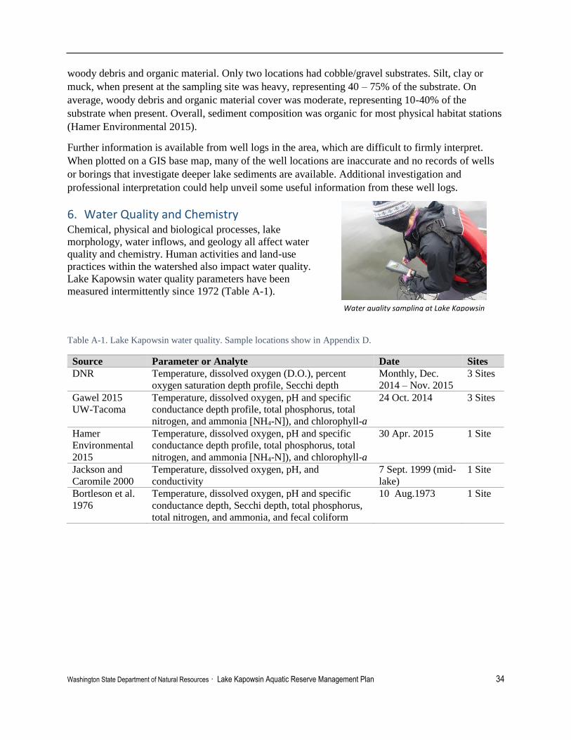
Washington State Department of Natural Resources · Lake Kapowsin Aquatic Reserve Management Plan 34
woody debris and organic material. Only two locations had cobble/gravel substrates. Silt, clay or
muck, when present at the sampling site was heavy, representing 40 – 75% of the substrate. On
average, woody debris and organic material cover was moderate, representing 10-40% of the
substrate when present. Overall, sediment composition was organic for most physical habitat stations
(Hamer Environmental 2015).
Further information is available from well logs in the area, which are difficult to firmly interpret.
When plotted on a GIS base map, many of the well locations are inaccurate and no records of wells
or borings that investigate deeper lake sediments are available. Additional investigation and
professional interpretation could help unveil some useful information from these well logs.
6. Water Quality and Chemistry Chemical, physical and biological processes, lake
morphology, water inflows, and geology all affect water
quality and chemistry. Human activities and land-use
practices within the watershed also impact water quality.
Lake Kapowsin water quality parameters have been
measured intermittently since 1972 (Table A-1).
Table A-1. Lake Kapowsin water quality. Sample locations show in Appendix D.
Source Parameter or Analyte Date Sites DNR Temperature, dissolved oxygen (D.O.), percent
oxygen saturation depth profile, Secchi depth
Monthly, Dec.
2014 – Nov. 2015
3 Sites
Gawel 2015
UW-Tacoma
Temperature, dissolved oxygen, pH and specific
conductance depth profile, total phosphorus, total
nitrogen, and ammonia [NH4-N]), and chlorophyll-a
24 Oct. 2014 3 Sites
Hamer
Environmental
2015
Temperature, dissolved oxygen, pH and specific
conductance depth profile, total phosphorus, total
nitrogen, and ammonia [NH4-N]), and chlorophyll-a
30 Apr. 2015 1 Site
Jackson and
Caromile 2000
Temperature, dissolved oxygen, pH, and
conductivity
7 Sept. 1999 (mid-
lake)
1 Site
Bortleson et al.
1976
Temperature, dissolved oxygen, pH and specific
conductance depth, Secchi depth, total phosphorus,
total nitrogen, and ammonia, and fecal coliform
10 Aug.1973
1 Site
Water quality sampling at Lake Kapowsin (November 2015, DNR)

Washington State Department of Natural Resources · Lake Kapowsin Aquatic Reserve Management Plan 35
Temperature & Dissolved Oxygen Lake Kapowsin follows a seasonal cycle of mixing in
fall/winter and vertical stratification in the spring/summer.
During the late fall and winter months, temperature is
relatively uniform throughout the water column, allowing
the water to mix. In the spring, lakes begin to stratify as the
uppermost layer of water (epilimnion) warms and the
deeper water stays cool (hypolimnion). The warmer
epilimnion, the cooler hypolimnion, and the distinct
transition zone between the two (metalimnion) can be
observed in summer temperature and dissolved oxygen
profiles (Figure A-1). Stratification isolates the deeper
layer of water from warmer surface water and the supply of
atmospheric oxygen which can severely deplete the amount
of dissolved oxygen in the hypolimnion. As the
temperatures decrease in the fall, surface waters cool and
winds begin to mix the epilimnion and hypolimnion. This is known as fall turnover.
Seasonal mixing/stratification at Lake Kapowsin can be seen in monthly water quality monitoring
data (Figure A-2; DNR 2015). Late fall and winter dissolved oxygen concentrations ranged between
8 mg/L to 12 mg/L, which is ideal for a wide range of aquatic species including cold water fish. The
lake began to stratify in May, and by June,
dissolved oxygen concentrations in the
hypolimnion had decreased to an annual low
of .07 mg/L. Dissolved oxygen stayed below 1
mg/L at the bottom of the lake until fall
turnover in October (Figure A-3). Extremely
low dissolved oxygen concentrations, or
hypolimnetic anoxia, can be especially
problematic in nutrient rich lakes where
bacteria decompose organic matter and
consume the already scarce amounts of
dissolved oxygen (Wetzel 2001; Hamer
Environmental 2015). Water quality
monitoring in August 1973 and September
1999 also revealed anoxic conditions below 6
m (0.3 mg/L and 0.2 mg/L, respectively).
Summertime dissolved oxygen concentrations
were below ideal conditions for most fishes
and could stress other aquatic organisms.
Further field monitoring is recommended to
understand summertime hypolimnetic anoxia
and possible impacts to aquatic species.
Glossary of Terms:
Epilimnion: Upper layer of water in a
lake that is comprised of uniformly
warm water that may be well-mixed.
Metalimnion: Middle layer of water in
a lake that marks the transition between
the top and bottom layers where
temperature changes rapidly with depth.
Hypolimnion: Bottom layer of water in
a lake that is comprised of uniformly
cold and relatively undisturbed water
(shown in Figure 3).
From Michaud 1991.
Figure A-1. Lake Kapowsin temperature and dissolved
oxygen profile 8 July 2015 at DNR_C (DNR 2015).
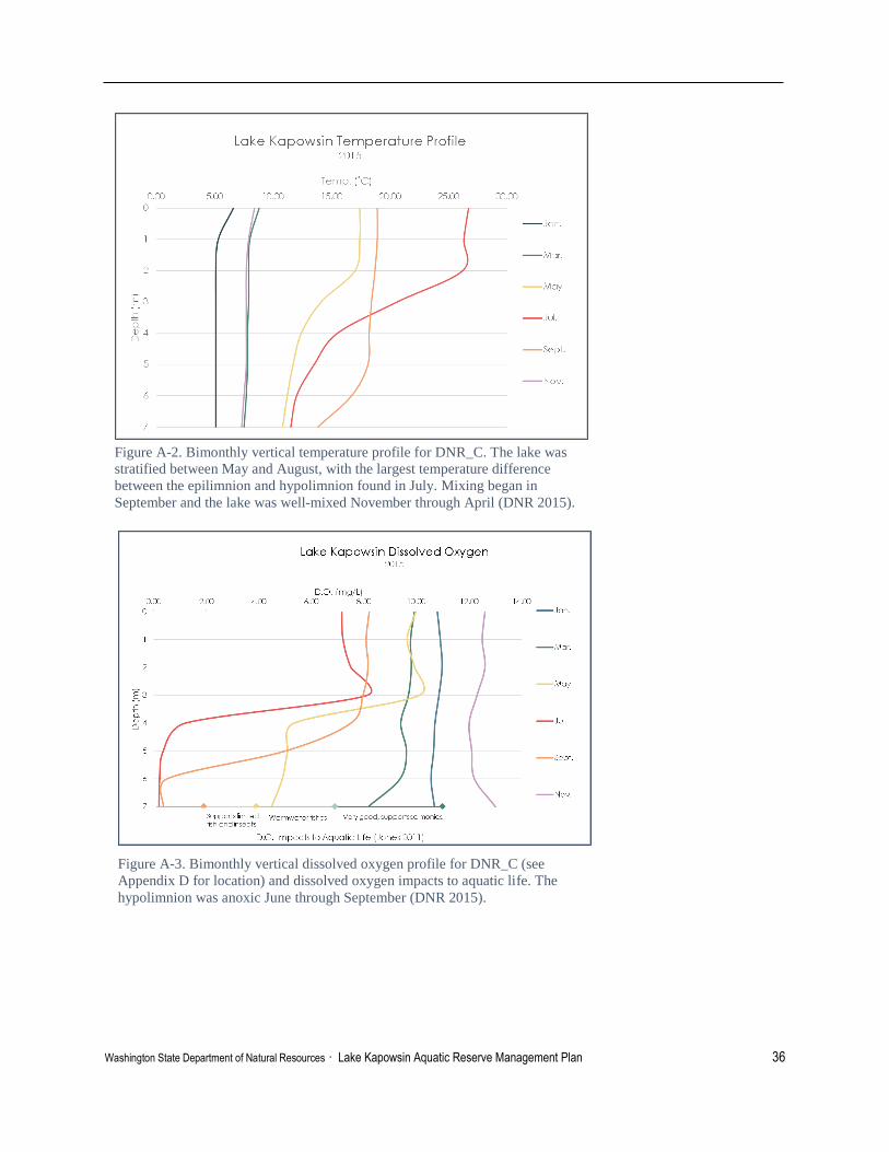
Washington State Department of Natural Resources · Lake Kapowsin Aquatic Reserve Management Plan 36
Figure A-2. Bimonthly vertical temperature profile for DNR_C. The lake was
stratified between May and August, with the largest temperature difference
between the epilimnion and hypolimnion found in July. Mixing began in
September and the lake was well-mixed November through April (DNR 2015).
Figure A-3. Bimonthly vertical dissolved oxygen profile for DNR_C (see
Appendix D for location) and dissolved oxygen impacts to aquatic life. The
hypolimnion was anoxic June through September (DNR 2015).

Washington State Department of Natural Resources · Lake Kapowsin Aquatic Reserve Management Plan 37
Water Clarity Secchi disk depth is a measure of water
transparency and clarity. The amount of both
dissolved and particulate matter in the water
column influence the water transparency
(Wetzel 2001). Seasonal algal growth, overland
flow carrying particulates, stream inflows, and
precipitation may all influence changes in
Secchi disk depth throughout the year and
create varying annual patterns. In 2015, Secchi
disk depth was greatest (4.2 meters) in July
(Figure A-4). Lake Kapowsin waters have a tea
color, termed humic stain, which is caused by
the presence of tannins and lignins released by
decaying plants and organisms. Hamer
Environmental suggests that this humic stain
decreases water clarity year-round and therefore
affect Secchi disk depths (2015).
Turbidity and total suspended solids were measured in April 2015 and were found to be relatively
low (Table A-2; Hamer Environmental 2015). Chlorophyll-a concentrations are a good
approximation of algal productivity and field sampling indicated higher chlorophyll-a concentrations
in April 2015 than October 2014 (Hamer Environmental 2015; Gawel 2015).
Table A-2. Lake Kapowsin water chemistry (Gawel 2014; Hamer Environmental 2015).
Analyte 24 October 2014
UW-Central 29 April 2015
Hamer-Index Total Suspended Sediment (mg/L) - 3.20 Turbidity (NTU) - 3.07 Chlorophyll-a (Index) (ug/L) 5.3 13.5 Chlorophyll-a (Littoral St J) (ug/L) - 16.2
Figure A-4. Monthly Secchi-disk depths at the DNR
sample sites (DNR 2015).

Washington State Department of Natural Resources · Lake Kapowsin Aquatic Reserve Management Plan 38
Specific Conductance and pH Specific conductance is a measure of the resistance to
electrical flow. It is used to approximate the amount of
dissolved minerals in water. Higher specific
conductance indicates more dissolved ions (Wetzel
2001). Lakes with higher specific conductance
generally “contain more salts, are often turbid and
nutrient poor (eutrophic)” (Helfrich et al. 2009).
Differences in specific conductance measurements can
also be used to differentiate water from different
sources, such as groundwater seeps or stream inflows
(Gawel 2015).
Specific conductance generally increases near the
bottom of a lake due to decomposing organic
materials, as documented by Bortleson et al. and
Jackson and Caromile (1976; 2000). However, Gawel
reported lower specific conductance with increasing
depth at the south and mid-lake sample stations in
October 2014 (Table A-3). This could indicate a
groundwater seep near these stations (Figure A-5).
Further monitoring is recommended to investigate this
finding and indicate whether additional research on groundwater sources is warranted (Gawel 2015).
Table A-3. Lake Kapowsin specific conductance at mid-lake sample stations (Bortleson et al. 1976; Gawel 2014;
Jackson and Caromile 2000).
Date and Location 1m depth 7m depth
10 Aug. 1973 56us/cm 68 us/cm
7 Sept. 1999 54.5 us/cm 99.1 us/cm
24 Oct. 2014 57.5 us/cm 54.7 us/cm
Lake Kapowsin pH was relatively vertically uniform at all three UW sites on 24 Oct. 2014 and
values ranged between 6.6 and 6.8. In April 2015, as the lake was beginning to stratify, surface pH
was 5.5 and reached 4.9 at 7 meters (Figure A-6; Hamer Environmental 2015). Most natural,
unpolluted lakes have pH values between 6 and 9. Low pH values are often found in natural lakes
with high dissolved organic matter (Wetzel 2001). Negative impacts are observed at pH values just
below 6 and can affect fish reproductive success, larval and egg survival, and eventually increase
adult mortality (Table A-4; Hamer Environmental 2015; Dodd and Whiles 2010). Additional pH
sampling is recommended to understand seasonal changes and possible impacts of low pH observed
in April 2015.
Figure A-5. Lake Kapowsin specific conductivity
profile (Gawel 2015).
Secchi depth
UW- Central

Washington State Department of Natural Resources · Lake Kapowsin Aquatic Reserve Management Plan 39
Table A-4. Influences of decreasing pH on several groups of aquatic organisms (from Dodd and Whiles 2010)
Organism or process Approximate
pH Value
Bacterial decomposition slows/fungal decomposition 5
Phytoplankton species decline/green filamentous periphyton dominate 6
Most mollusks disappear 5.5-6
Most mayflies disappear 6.5
Beetles, bugs, dragonflies damselflies disappear 4.5
Caddis flies, stoneflies, Megaloptera disappear 4.5-5
Salmonid reproduction fails, aluminum toxicity increases 5
Most adult fishes harmed 4.5
Most amphibians disappear 5
Waterfowl breeding declines 5.5
Nutrients Nutrients such as nitrogen and phosphorous support algal production in lakes. Dissolved inorganic
nitrogen is naturally found in lakes in the form of nitrate, nitrite and ammonium. The type of
dissolved inorganic nitrogen may indicate which algal species will be abundant, and high levels of
nitrite are often associated with polluted waters (Dodd and Whiles 2010; Hamer Environmental
2015).
Phosphorus is an important nutrient for plant growth and can be a limiting factor for biological
productivity. The concentration of phosphorus available for algal growth is generally low in lakes,
and small increases in phosphorus can produce large increases in algal growth (Hamer
Environmental 2015). Total phosphorus concentrations observed October 2014 and April 2015 are
24-Oct-14
Secchi Depth (m) 29-Apr-15
29-Apr-15
0
1
2
3
4
5
6
7
8
4 5 6 7 8D
ep
th (
m)
pH level
Figure A-6. Lake Kapowsin pH profile for 24 October 2014 (UWT_C) and
29 April 2015 (H_index) (Hamer Environmental 2015; Gawel 2015).
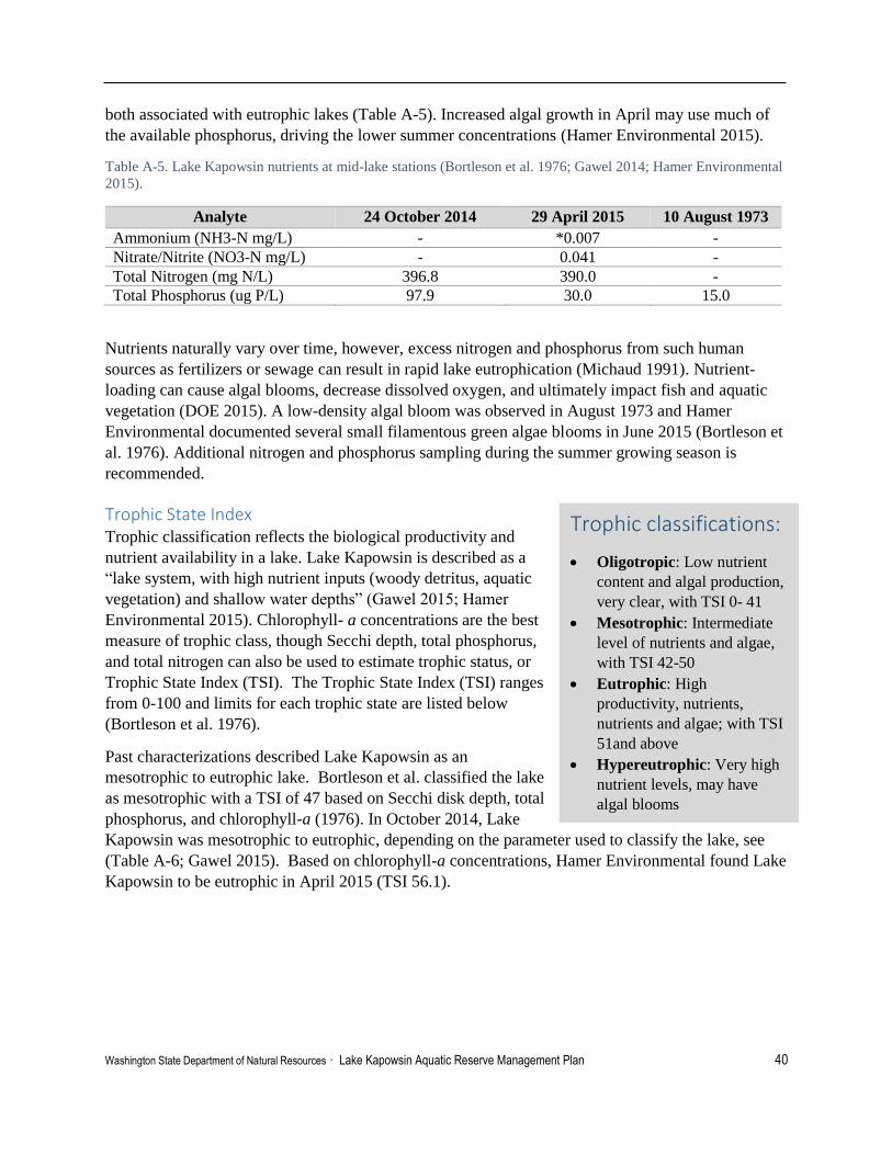
Washington State Department of Natural Resources · Lake Kapowsin Aquatic Reserve Management Plan 40
both associated with eutrophic lakes (Table A-5). Increased algal growth in April may use much of
the available phosphorus, driving the lower summer concentrations (Hamer Environmental 2015).
Table A-5. Lake Kapowsin nutrients at mid-lake stations (Bortleson et al. 1976; Gawel 2014; Hamer Environmental
2015).
Analyte 24 October 2014 29 April 2015 10 August 1973
Ammonium (NH3-N mg/L) - *0.007 -
Nitrate/Nitrite (NO3-N mg/L) - 0.041 -
Total Nitrogen (mg N/L) 396.8 390.0 -
Total Phosphorus (ug P/L) 97.9 30.0 15.0
Nutrients naturally vary over time, however, excess nitrogen and phosphorus from such human
sources as fertilizers or sewage can result in rapid lake eutrophication (Michaud 1991). Nutrient-
loading can cause algal blooms, decrease dissolved oxygen, and ultimately impact fish and aquatic
vegetation (DOE 2015). A low-density algal bloom was observed in August 1973 and Hamer
Environmental documented several small filamentous green algae blooms in June 2015 (Bortleson et
al. 1976). Additional nitrogen and phosphorus sampling during the summer growing season is
recommended.
Trophic State Index Trophic classification reflects the biological productivity and
nutrient availability in a lake. Lake Kapowsin is described as a
“lake system, with high nutrient inputs (woody detritus, aquatic
vegetation) and shallow water depths” (Gawel 2015; Hamer
Environmental 2015). Chlorophyll- a concentrations are the best
measure of trophic class, though Secchi depth, total phosphorus,
and total nitrogen can also be used to estimate trophic status, or
Trophic State Index (TSI). The Trophic State Index (TSI) ranges
from 0-100 and limits for each trophic state are listed below
(Bortleson et al. 1976).
Past characterizations described Lake Kapowsin as an
mesotrophic to eutrophic lake. Bortleson et al. classified the lake
as mesotrophic with a TSI of 47 based on Secchi disk depth, total
phosphorus, and chlorophyll-a (1976). In October 2014, Lake
Kapowsin was mesotrophic to eutrophic, depending on the parameter used to classify the lake, see
(Table A-6; Gawel 2015). Based on chlorophyll-a concentrations, Hamer Environmental found Lake
Kapowsin to be eutrophic in April 2015 (TSI 56.1).
Trophic classifications:
Oligotropic: Low nutrient
content and algal production,
very clear, with TSI 0- 41
Mesotrophic: Intermediate
level of nutrients and algae,
with TSI 42-50
Eutrophic: High
productivity, nutrients,
nutrients and algae; with TSI
51and above
Hypereutrophic: Very high
nutrient levels, may have
algal blooms

Washington State Department of Natural Resources · Lake Kapowsin Aquatic Reserve Management Plan 41
Table A-6. Lake Kapowsin Trophic State Index on 24 October 2014 based on multiple parameters, from Gawel
2015.
Parameter TSI value Trophic State
TSI (Secchi Disk ) 48.64 Mesotrophic
TSI (Chlorophyll-a) 46.61 Mesotrophic
TSI (Total Phosphorus) 69.35 Eutrophic
TSI (Total Nitrogen) 43.00 Mesotrophic
Lakes may naturally become eutrophic over time as nutrients accumulate, plant production increases,
and sedimentation fills in the lake. Eutrophic lakes can be highly productive and support diverse fish
and aquatic plant communities (Dodds and Whiles 2010). Most lakes experience seasonal
fluctuations, with the highest productivity generally in the summer. Further field sampling is
recommended in the summer when the lake may be more eutrophic.
7. Physical Habitat The lake has a unique and rare geologic history that created a relatively shallow-to-medium depth
lake with a dense drowned subfossil forest. Jackson and Caromile described Lake Kapowsin as
having a maximum depth of 8.8 meters (2000). Abundant submerged subfossil stumps, large
amounts of floating logs and other woody debris, provide structurally complex habitat for numerous
species. The predominantly natural, undeveloped shoreline, riparian vegetation and diverse wetland
areas maintain a sheltered, productive zone for fish and wildlife spawning, rearing, foraging, and
refuge. The site is contained within a moderately large system of forested wetlands and emergent
marsh wetland habitats at both ends of the lake with a significant component of native vegetation.
Input and outfall streams at both ends of the lake are integrated into these extensive wetland areas
providing habitat connectivity for several salmon species, other fishes, waterfowl, amphibians and
mammals.
Drowned Subfossil Forest Five hundred years ago, the Electron mudflow came down the Puyallup River valley and forced its
way up the Kapowsin Creek tributary, terminating with a 30-foot high mudflow dam at a constriction
in the valley. At the time, a dense, mature forest occupied the tributary valley. The after-effects of the
mudflow event resulted in the flooding of the Kapowsin Creek valley between the 30-foot high
mudflow debris dam, and a higher elevation delta fan farther up-valley, and the subsequent drowning
of the mature forest. The newly formed lake retained the standing trees as they were when the valley
was flooded by water. The original condition of nearly all of the lake’s bedlands with the drowned
coniferous forest exists present day, and most of these subfossil stumps remain vertical and
embedded in the substrate. Although most species, except western red cedar, had probably rotted to
water level within two centuries after the drowning event, many of the residual trunks standing above
the lake water level were cut off at the lake’s surface in the late 1800’s to early 1900’s (P. Pringle,
Centralia College, personal communication, 2015). There are still many large stumps throughout the
lake; the biggest of these observed by Crandell in his investigations was 5 feet in diameter at the lake
surface at a point where the lake was 22 feet deep (1963).

Washington State Department of Natural Resources · Lake Kapowsin Aquatic Reserve Management Plan 42
Drowned trunks - Large woody structure Large pillars of drowned coniferous trees persist within Lake Kapowsin’s waters. In addition to being
a unique, key physical element of the lake environ, this large woody structure (LWS) significantly
influences the form and ecological functioning of the lake ecosystem (Maser et al. 1988; Nakamura
and Swanson 1993; Collins and Montgomery 2002; Montgomery and Bolton et al. 2003;
Montgomery and Masson et al. 2003). The prevalence of LWS in the lake provides a unique variety
of ecosystem functions. LWS in open water is known to attract fish and bird populations to the
vicinity. The submerged stumps, offer complex physical habitat for a variety of other species
including amphibians, reptiles, and invertebrates. The structures function as perching areas for birds,
shelter and protection, foraging and spawning substrate for fishes, amphibians and invertebrates.
Largemouth Bass have been observed guarding nests on submerged stumps in the middle of the lake.
The bark and fibrous texture of the partially decayed wood presents other physical and biochemical
changes, while providing a base for bacteria, fungus, algae, epiphytes and other microorganisms to
flourish. This attracts a plethora of grazers and detritivores and associated prey. The abundance of
LWS also serves as thermal protection and a
medium for long term carbon sequestration other
than the atmosphere. Overall, LWS contribute vital
organic material to the aquatic ecosystem by
adding wood particulate, organic nutrients and
debris to the water column and bottom sediment
that can affect water quality, vegetation, sediment
composition and invertebrate species diversity. If
submerged woody debris is removed in lake
nearshore areas, it permanently reduces the
biomass of primary and secondary productivity
(particularly invertebrates) (Smokorowski et al.
2006).
Large woody debris - Lografts and floating log community In addition to the prominent submerged forest, other large woody debris (LWD) and LWS, are
prevalent throughout the lake ecosystem in large floating log raft areas, small log assemblies
bordering the lake shore, contributing to fringing wetlands, as well as other shoreline areas where
trees have fallen into the lake. In addition to increasing habitat complexity, the floating log rafts and
other LWD provide many similar ecosystem benefits as the LWS of the drowned forest. Specific
contributions of LWD include stabilizing, shoreline areas, reducing water flow, trapping sediments,
nutrients and leaf litter, increasing areas for insect production and producing small protected
backwater areas that offer refuge and suitable structure for amphibian egg masses. The structural
diversity created by LWD is essential to many aquatic species for refuge (hiding), overwintering
habitat, and juvenile rearing (Knutson and Naef 1997).
Large woody structure, Lake Kapowsin (DNR)

Washington State Department of Natural Resources · Lake Kapowsin Aquatic Reserve Management Plan 43
Bortleson et al. described Lake Kapowsin with “The north end of the lake is choked with floating
logs and snags extending 1,000-2,000 feet from shore…the next 1,000 feet into the lake was covered
with submersed plants interspersed with stumps and snags” (1976). This imposing area with
interconnected floating logs, LWD and log rafts spans across the narrowing terminus in the north
portion of the lake creating an extensive unique structural habitat area. An earlier description by
Walcott reported Lake Kapowsin as being “Used partially for log storage” (1973). Perhaps part of
this northern area was used for log storage, but prevailing winds have pushed LWD north and further
compacted this floating log/raft/wetland habitat area. Varied configurations of floating logs and
partially submerged LWD and log raft masses create a partial barrier at the north end of the lake. The
logs and rafts north of this barrier, lay in
all directions creating a patchwork of
lushly vegetated log islets contrasting
with occasional bare floating logs
amongst a maze of small channels. Logs
and log rafts support a high diversity of
mostly wetland plants, including
sphagnum moss, dwarf shrubs (Labrador
tea and swamp laurel), and marsh
cinquefoil. Some sparsely vegetated
sections of logs feature round-leaved
sundews and support sphagnum moss, a
typical bog species. More densely
compacted logs support assorted
vegetative types, such as small alder trees, blackberries, fireweed, as well as wetland vegetation.
Narrow channels with patches of open water are interspersed between rafts, some areas support
emergent, floating, and submerged vegetation, ranging from sedges, cattails, pond lilies, large-leafed
pondweed and various other submerged plant species. Like the large structural subfossil trunks of
the drowned forest, log rafts also attract and support epiphytes, invertebrates, amphibians and fishes.
In areas such as the lower Columbia River, Largemouth Bass have been observed spawning on log
rafts and other woody debris (Hamer Environmental 2015). Three separate wetland areas of this
northern floating log/ habitat complex were surveyed by Hamer Environmental and were
characterized with slightly different structural composition and plant assemblages.
The LWS and LWD provide the foundation for and are an integral part of most of the wetland
communities throughout the lake area. Consequently, this distinctive floating log raft environ melds
into lake fringe wetlands areas and also shares many of the same functions, characteristics, fauna and
plant species as other wetland areas around the lake. In ten wetland sites evaluated by Hamer
Environmental, floating logs were omnipresent and at a third of the sites represented the dominant
constituent.
Wetland Habitat Areas The plants, water and soils of wetlands are among the most productive ecosystems on the planet
(Tiner 1989). They are essential not only to waterfowl and scores of other wildlife species, but also to
the overall quality of life in the region. The diversity of creatures found in wetlands stems from the
Sundew at Lake Kapowsin (March 2015, DNR)

Washington State Department of Natural Resources · Lake Kapowsin Aquatic Reserve Management Plan 44
uniqueness of wetland habitat types. In unperturbed situations, the combination of hydrology, soil-
type, plant cover and composition determine the level of biochemical processing and other functions
related to trapping and transforming sediment and nutrients. The habitat structure, function and
organisms, primarily smaller invertebrates, bacteria, algae and decaying plants create a productive
base for the food chain that serve a high diversity and abundance of larger organisms. Wetlands are
also known to play a vital role in the landscape through hydrologic functions related to maintaining
the water regime in a watershed by intercepting surface flow, retaining water, reducing flooding, and
potentially minimizing drought.
Several types of wetland communities are associated with the Lake Kapowsin ecosystem. A large,
mostly forested/scrub-shrub wetland complex persists along Kapowsin Creek just north of the lake.
This wetland system extends southerly along the lake shore including a well-vegetated riparian area,
then merges with the large floating log complex. The extensive vegetated transitional zone provides
sheltered nursery grounds and migratory passage for several species, including salmonids heading to
their upstream spawning habitat.
Another large wetland complex emerges out of
the south margin of the lake. The wetland
community transitions from a unique exposed
flats area with emergent wetland plants, to a large
scrub/shrub wetland community, then grades into
a deciduous forested wetland. The extensive and
diverse aquatic vegetation community in this area
is partially due to low-sloping lake shore
topography forming an extensive shallow littoral
zone with mudflats (Hamer Environmental 2015).
These wetlands also provide habitat connectivity
from upland regions and stream corridors to the
open lake area. A host of fish and wildlife species, including waterfowl, warmwater fishes, sensitive
salmon species, amphibians and other wetland-dependent wildlife utilize these habitat areas during
several life phases. According to Jackson and Caromile the mixture of aquatic vegetation and wood
debris provides optimal habitat conditions for several warmwater fishes, particularly Largemouth
Bass and Bluegill (2000). In due course, the entire community of species present in the basin rely on
the rich habitat diversity provided by the mosaic of flats, emergent marsh areas, sloughs, streams,
scrub/shrub and fringing wetland expanses.
Hamer Environmental mapped 28 lake-fringe wetland areas around Lake Kapowsin, comprising 48
percent of the shoreline areas of Lake Kapowsin (2015). Additionally, Hamer Environmental
conducted wetland inventories at ten sites along the perimeter of the lake, as well as carried-out ten
aquatic plant transects on the lake on June 8, 2015. Each of ten wetland sites were rated to provide
information on wetland quality on the Lake and to highlight those wetland localities with higher
functions, uniqueness, priority for further enhancement, and/or study. The rating resulted in a range
of Category I to Category III wetlands found at Lake Kapowsin. One wetland area received a dual
rating as both Category I and Category III wetland, due to a portion of the wetland meeting the
criteria to be classified as a bog (Category I, more detail later). Two wetland sites were rated as
Wetlands, Lake Kapowsin (DNR)

Washington State Department of Natural Resources · Lake Kapowsin Aquatic Reserve Management Plan 45
Category II wetlands, which perform all wetland functions well, or one group of functions very well,
and are difficult to replace. The remaining seven (plus the half) wetland sites were rated as Category
III wetlands, which typically perform wetland functions moderately well, have likely been disturbed
or degraded somehow, may be less diverse than other wetlands, and are more likely to be replaceable
through mitigation efforts. All wetland sites received moderate to high scores for improving water
quality and high scores for providing important wildlife habitat and habitat functions. The hydrologic
functions of the lake-fringe wetlands scored low to moderate, however lake-fringe wetlands are
deemed less critical for erosion control and peak water flow reduction than other types of wetland
systems (Hruby 2014).
Several wetland sites on Lake Kapowsin exhibited soils, moss layer and plant species composition
consistent with bog wetlands. However, these wetland sites (1, 2, 3, 4 and most of 6), didn’t meet the
minimum plant cover (30 percent of plant species exclusive to bogs) requirement to be rated as
Category I bog (Hruby 2014). Only a portion of one wetland on the southwest shore of Jaybird Island
met the minimum criteria to be classified and rated as a Category I bog. Category I bog wetlands are
not common, and are a priority for protection because restoration of bog habitat is difficult due to the
slow rate of formation and delicate balance of abiotic and biotic factors (Rigg 1958; Hruby 2014).
Littoral Areas The littoral zone in a lake is defined as the nearshore area where sunlight penetrates deep enough to
allow for aquatic plants to grow. Jackson and Caromile described Lake Kapowsin as having steep
sloping shorelines in areas and extensive littoral zones located at the northern and southern ends of
the lake, with many shoreline irregularities (2000). The euphotic depth, which is the lower limit of
the littoral zone is located at an average of about 2.4 meters depth in Lake Kapowsin (DNR 2015).
The littoral zone captures much of the sediments, detritus, and other constituents washing in from the
watershed and processes these materials before they reach the limnetic zone. Both submergent and
emergent vegetation arise in the littoral zone, providing primary productivity and habitat for a diverse
assortment of species. According to Hamer Environmental, submersed rooted plants (macrophytes)
growing at the lake margin also help define the littoral zone (2000). These aquatic plants provide
substrate for algae and other epiphytes, insects, crustaceans, and fishes that use this area for breeding,
cover and foraging. In addition to habitat structure for this assemblage of species, submergent
vegetation in nearshore areas also supply a vital food source. In most littoral areas around the lake,
suitable conditions are available, i.e. sediment, detritus and structure, to support macrophytes,
emergent vegetation and the associated biological communities identified by Hamer Environmental
in 2015.
Riparian Habitat Areas Riparian zones are defined as the transitional zone between land and water environments that are
directly upland of the shoreline and provide important ecological functions such as improving water
quality, shoreline stabilization, and creating habitat. Vegetated riparian areas play an important role
in aquatic ecosystems by sustaining beneficial habitat which provides shade, nutrients, and large
woody debris to both aquatic and terrestrial ecosystems. These vegetated areas adjacent to the lake
and wetlands also contribute to maintaining healthy ecosystem conditions by suppressing the
erosional processes that move sediment, and by mechanically filtering and/or storing upland

Washington State Department of Natural Resources · Lake Kapowsin Aquatic Reserve Management Plan 46
sediments before they can enter waterbodies (Town of Eatonville 2010). If stable, riparian areas that
are occupied by early-successional native species such as alder, willow, and other shrubs, will
transition toward a plant community dominated by conifers. These functions take many decades to
recover once disturbed (Washington State Department of Agriculture 2012 Progress report).
The observation of a natural, well-vegetated riparian shoreline is substantiated by Hamer
Environmental. Ten sample sites evaluated physical habitat within the littoral, shoreline, and riparian
areas of the lake. “At nine of the sites, “90-100% of the vegetation present within the riparian area
was native” with four of the plots shaded by a mixed conifer and deciduous tree canopy at least 15’
tall (2015).
Generally, shoreline areas along Lake Kapowsin, outside of wetlands, consist of a narrow fringe of
understory emergent vegetation before grading into upland habitats. Riparian habitats along the lake
were also varied, but tended to be deciduous forest along the south, southwest and northwest banks,
and were mixed conifer-deciduous or conifer forest along Jaybird Island and the east banks of the
lake (Hamer Environmental 2015).
Overall, emergent aquatic vegetation covers approximately 20 percent of the Lake Kapowsin
shoreline mostly from the extensive wetland areas along the northeast and southwest ends of the lake
(Pierce County 2009a). For all wetland sites combined, Hamer Environmental documented a total of
45 submerged, floating & emergent aquatic plant species, indicating high species diversity.
Additional wetland and plant surveys should be conducted during different periods of the growing
season May - September targeting sites with suitable conditions for specific rare plants.
Shoreline zones contained a mix of native and non-native species. A few areas along the southwest
and northwest shoreline had higher concentrations of non-native and invasive species, including
yellow flag iris Iris pseudacorus and non-native redtop grass Agrostis gigantea. Native, common cat-
tail Typha angustifolia was found throughout the lake shorelines, frequently as the dominant plant
cover, particularly along eastern shoreline areas.
Upland Habitat Areas Farther from the lake shorelands, the majority of the adjacent uplands are populated by lowland
coniferous forests. Almost 90% of the drainage area for Lake Kapowsin is either forested or part of
the large tract of forestry lands to the east. The forest cover provides for greater infiltration, surface
water storage, soil stabilization, and evapotranspiration. These forests are dominated by Douglas fir,
western hemlock, and western red cedar. Breeding, feeding, nesting, migration and rearing habitat for
vertebrate and invertebrate grazers and seed eaters, omnivores, carnivores, and scavengers exist
throughout the area (Kruckeberg 1991).
Upland habitat has been modified and altered by human use at locations along the shoreline.
Disturbances in the nearshore area include parts of the historic Kapowsin town site, one residence,
remnant pilings in the lake, logs and debris from former mill and logging operations, boat ramps,
small docks, and farther upland clearing and constrictions from roads and bridges. Activities that
could contribute to sediment and nutrient input to the lake, include removal of riparian vegetation,
altered hydrologic processes associated with the mine operations, a shoreline adjacent rail line near
the western lake shore, and historic and present-day forest practices. Generally, effects from

Washington State Department of Natural Resources · Lake Kapowsin Aquatic Reserve Management Plan 47
development to associated lake systems are well-documented and can result in complex and varied
consequences to biological communities and the overall integrity of the lacustrine ecosystem.
(Rosenberger et al. 2008; Edmondson 1994; Leavitt et al. 2006).
A widespread threat throughout the State and common disturbance in some upland areas around Lake
Kapowsin are infestations of invasive species. Invasive plants can drastically alter the landscape and
have long-term ecological effects if not controlled. The Lake Kapowsin shoreline is affected by
landscape transforming species capable of suppressing trees and understory plants including English
ivy, English hawthorn, Himalayan blackberry, Scotch broom, knotweed species, and invasive
clematis. These species are found in or near disturbed areas and dump sites near the lake and railroad
right of way. Knotweed is listed as Class B noxious weed and affects riparian areas by competing
with and crowding out native vegetation, reducing nutrient inputs, and negating riparian restoration
efforts if not eradicated (WSDA 2013).
Noxious Weeds The presence of non-native invasive plant species can threaten the integrity of aquatic and riparian
ecosystems. These introduced species are highly competitive with native species, often difficult to
control or eliminate, and in extreme cases may be quite destructive to native ecosystems (King
County). Six species of noxious weeds, all Class C, were identified during aquatic plant and lake-
fringe wetland surveys carried-out by Hamer and associates in the spring and summer of 2015 (Table
A-7). A total of 22 noxious weed infestations were documented during April and June field survey
efforts. Aquatic Reserve staff observed purple loosestrife present in the northern wetland and
portions of northwest fringing wetland areas. Purple loosestrife is a class B noxious weed that is a
vigorous competitor and can crowd out native plant species. Significantly, no observations of
noxious aquatic plant species such as, Eurasian watermilfoil Myriophyllum spicatum, Brazilian
elodea Egeria densa, curly-leaf pondweed Potamogeton crispus or fragrant water lily Nymphaea
odorata were made. However, lack of observation does not mean probable absence, as many areas of
the lake were not thoroughly surveyed for noxious weeds and most detections were incidental to
other data being collected (Hamer Environmental 2015).
Table A-7. Noxious Weed species identified at Lake Kapowsin (DNR 2015; Hamer Environmental 2015).
NRCS
Code
Scientific Name Common Name Weed Class
IRPS Iris pseudoacorus
yellow flag iris C
PHAR3 Phalaris arundinacea reed canarygrass C RULA Rubus laciniatus evergreen blackberry C RUAR9 Rubus armeniacus (was R. discolor) Himalayan blackberry C HYPE3 Hypericum perforatum common St. Johnswort C
CIAR4 Cirsium arvense Canada thistle
C
Lythrum salicaria Purple Loosestrife B
Hamer Environmental found yellow flag iris infestations as the most widespread non-native invasive
weed around the perimeter of the Lake study area. Iris are found in patches amongst other emergent
plant species fringing the shoreline, in the northeastern areas of the lake, and in small clumps on
vegetated floating logs. In the same area, Himalayan Rubus armeniacus and evergreen blackberry R.

Washington State Department of Natural Resources · Lake Kapowsin Aquatic Reserve Management Plan 48
laciniatus were documented sporadically and in small clusters. Dense patches of Himalayan and
evergreen blackberry are located along the west and northern upland portions of the lake and
dominate the understory vegetation. Reed canarygrass Phalaris arundinacea infestations were
limited to two small patches at the northern end of the lake and a larger infestation within the
southern wetland along a narrow stream channel. Typically, Reed canarygrass is found more
abundantly along the lake margins and fringe wetland areas in western Washington. Curiously,
redtop grass Agrostis gigantea, an introduced species not classified as a noxious weed, occupies this
disturbed shoreline niche at the lake. Canada thistle Cirsium arvense and common St. Johnswort
Hypericum perforatum were also noted in single, smaller patches on vegetated floating logs in the
northeastern wetland area of Lake Kapowsin (Hamer Environmental 2015). This is a preliminary
invasive species list, and a full invasive inventory should be completed as part of reserve
management and in cooperation with neighboring landowners. Treatment of Class C weeds is
recommended but not mandatory, due to their widespread establishment throughout Washington
State (Washington NWCB 2015). However, new and small infestations of Class C noxious weeds
should be treated to avoid the development of large infestations.
8. Fish and Wildlife Resources Lake Kapowsin is one of the most popular fishing locations in the lowland Puget Sound area for
year-round, warmwater and trout fishing. The lake has a year-round fishery managed by Washington
Department of Fish and Wildlife (WDFW) as a mixed-species water body. The lake provides good
fishing opportunity for Largemouth Bass Micropterus salmoides, Yellow Perch Perca flavescens, Rock
Bass Ambloplites rupestris, Black Crappie Pomoxis nigromaculatus, Bluegill Lepomis macrochirus,
Pumpkinseed Lepomis gibbosus, Brown Bullhead Ameiurus nebulosus, and stocked Rainbow Trout
Oncorhynchus mykiss (Jackson and Caromile 2000). Since the 1960s, the lake has received annual
plants of legal-sized Rainbow Trout. Even with annual trout plantings, warmwater fish species,
particularly Largemouth Bass, Black Crappie, Yellow Perch, and Rock Bass, are the primary target
for most anglers. An angler creel survey conducted in 2008 by WDFW, verified that the majority of
anglers are targeting warmwater fish (S. Caromile, WDFW, personal communication, 2015). Coho
Salmon Oncorhynchus kisutch, steelhead (anadromous Rainbow Trout), and Cutthroat Trout
Oncorhynchus clarki have been observed in the lake. Coho Salmon and steelhead are likely to move
through the lake to reach spawning habitat on Ohop Creek (B. Smith, Puyallup Tribe, personal
communication, 2015). Because Coho Salmon fry may remain in freshwater for up to two years
before making their way to the ocean, the lake is potentially rearing habitat for this species. Coho
Salmon late release net pens existed in the lake for 5 years. After the pens were removed from the
lake, Coho Salmon returns persisted for several years in the small tributaries that feed the lake as
well as Ohop Creek. Coho Salmon are also stocked yearly in the upper reaches of Ohop Creek to
supplement the current spawning population (R. Ladley, Puyallup Tribe, personal communication,
2015).
Fish
Warmwater fishes Warmwater fish introductions were widespread in Washington State and practically all lowland lakes
and many river systems in the region contain introduced fish (Bonar et al. 2004). There are records of
warmwater fish species being stocked in Lake Kapowsin as early as 1906, continuing until 1939. In

Washington State Department of Natural Resources · Lake Kapowsin Aquatic Reserve Management Plan 49
1999 when Jackson and Caromile surveyed Lake Kapowsin they reported collecting eight species of
fish from the lake. Of the fish collected, Largemouth Bass and Bluegill were the most abundant, at
32.6% and 42.5% respectively. In terms of total biomass, Largemouth Bass accounted for 32.7%,
while Bluegill represented 21.8 %.with the combined biomass of for both species adding up to 54%
of the total catch. According to Jackson and Caromile the mixture of aquatic vegetation and timber
(LWS) provides optimal habitat conditions for Largemouth Bass, Bluegill, and other warmwater fish
(2000).
Other fish sampled during the survey, in order of highest to lowest abundance, included: Yellow
Perch, Rock Bass, Pumpkinseed, Black Crappie, Brown Bullhead, and Coho Salmon (Jackson and
Caromile 2000). Lake Kapowsin has the diversity of habitat types, including masses of LWS and
LWD that can sustain a diverse population of warmwater fishes. For instance, at the top of the
prominent submerged stumps, Largemouth Bass have been observed guarding their nests, while
Black Crappie congregate around the stumps and pilings. The large percentage of shoreline with
fringing wetland areas can provide Bluegills and Pumpkinseed with high quality suitable vegetated
backwater habitat.
Largemouth Bass males generally excavate circular depressions in one to ten feet of water in which
females deposit their eggs. Males guard the nest during incubation and early fry growth. Largemouth
Bass begin their spawning activity in the spring when water temperatures reach 60 to 65° F. Firm
bottom areas at a depth of about three feet are preferred, but successful spawning is sometimes
accomplished over sand, and even silted bottoms. In lakes, the amount of relatively shallow water
effectively determines the carrying capacity for largemouths. Largemouth Bass are skilled predators.
They feed not only by sight, but also use their highly-developed olfactory and auditory senses. The
lateral line functions as a sensitive low-frequency sound receptor, allowing bass to zero in on their
prey in highly turbid waters or during the darkest nights. Largemouth Bass are generally found near
cover, either aquatic vegetation, stumps, docks, rocks, or on the bottom near obstructions or changes
in depth. Because of their tremendous reproductive potential and their ability to tolerate a wide range
of temperatures, species such as largemouths will likely be the most able to adapt and thrive in a
changing climate (Wydoski and Whitney 2003).
Black Crappies are the earliest of the centrarchids to spawn in the lake, actively spawning when
water temperatures approach 55° F. Unlike bass, these fish are gregarious, and commonly found in
schools during the spring. The schools break up somewhat after spawning, and fish are more likely to
be scattered and in deeper water during the summer. Black Crappies seem to be more dependent on
vegetation, but are often found congregated around old pilings, stumps, snags, or near rocks (WDFW
2015b). Bluegill and Pumpkinseed characteristically inhabit vegetated, quiet or slow-moving waters.
They spawn when water temperatures approach 70° F, congregating in large groups on common
spawning grounds in water six to 12 inches deep. The fish may move to deeper water later in the
summer as temperatures climb.
According to local fishermen, the Rock Bass fishery in Lake Kapowsin is unique. Rock Bass are not
common in the state and their distribution in Washington is probably confined to a few lakes and
small tributary streams in Pierce and Thurston Counties, and in slower stretches of the Chehalis
River in Lewis County. Their origin in Washington lakes is uncertain. Immediately preceding and
during the spawning period, adult females congregate in pools of streams until they become ripe

Washington State Department of Natural Resources · Lake Kapowsin Aquatic Reserve Management Plan 50
(Wydoski and Whitney 2003). The males make a nest by digging a depression in gravel where the
current is slow and they may also make a nest in shallow water along the shoreline (Wydoski and
Whitney 2003). Consequently, Kapowsin Creek and Ohop Creek may be important spawning areas
for Rock Bass that inhabit Lake Kapowsin (Hamer Environmental 2105).
Yellow Perch spawn earlier than crappies, beginning when water temperatures reach 45 or 50° F.
Spawning is extended over a short period, each female extruding all of her eggs at once.
Reproductive potential (fecundity) is high, with as many as 15,000 eggs for a six-inch fish, (Wydoski
and Whitney 2003) and many times more for larger fish. Consequently, perch eggs provide a great
deal of forage for other species.
Bullheads, like other catfish, are omnivorous, eating almost anything that is available. Almost all
food is taken on or near the lake bottom. A member of the catfish family, Brown Bullheads are often
abundant in water a little muddier and warmer than most other fish prefer. They can tolerate high
water temperatures and low dissolved oxygen levels that would be lethal to most other game fish.
Having a highly-developed sense of smell and touch, bullheads are well equipped to negotiate murky
waters and find food. Female bullheads will lay from 2,000 to over 10,000 eggs, depending on size.
Spawning usually occurs when water temperature reaches about 70° F (Wydoski and Whitney 2003).
Although these warmwater fishes are non-native to Lake Kapowsin, (as well as other western
Washington lakes), most of these popular species were deliberately introduced to enhance fishing
opportunities. WDFW does not consider any of these as an “undesirable” fish. “Undesirable fish are
species that are unwanted, like a weed, and therefore unused; or more often, a species that makes it
difficult or impossible to produce and manage a healthy population of more desirable fish.” (WDFW
2005). In 2008, after WDFW improved access to the lake, angler creel surveys showed increased
fishing effort and a targeted preference for the warmwater species. Accordingly, WDFW will
continue to manage Lake Kapowsin as a mixed-species lake.
Trout and Salmon Various Rainbow Trout stocks have been the primary species stocked in Lake Kapowsin since the
1960’s and has continued to be supported by WDFW, the Tribes and other recreational fishing
groups. In 2015, more than 30,000 Rainbow Trout were planted between March and May (WDFW
2015).
In Jackson and Caromile’s survey in 1999 of Lake Kapowsin, they caught Rainbow Trout as well as
Coho Salmon. The lake supports Coho Salmon and adfluvial Cutthroat Trout, which move through
the lake, as well as, an occasional Steelhead (B. Smith, Puyallup Tribe, personal communication,
2015). Coho Salmon travel through the lake into upper Ohop Creek to spawn. Upper Ohop Creek is
technically considered the continuation of Kapowsin Creek and is the main feeder stream to Lake
Kapowsin (Town of Eatonville 2010). Several other smaller lake tributaries provide good spawning
and rearing habitat and historically supported Coho Salmon runs (R. Ladley, Puyallup Tribe,
personal communication, 2015). Because young Coho Salmon often remain in freshwater for up to
two years before making their way to the ocean, the lake provides dependable rearing and migratory
opportunity. The lake also may attract Coho Salmon fingerlings from other portions of the upper and
mid-Puyallup basin, as sizeable good quality winter rearing habitat is not very accessible in the mid
basin area (B. Smith, Puyallup Tribe, personal communication, 2015)

Washington State Department of Natural Resources · Lake Kapowsin Aquatic Reserve Management Plan 51
From 1993 to 1997, the Puyallup Tribe fisheries staff transported approximately 200,000-one-year
old juvenile Coho Salmon from WDFW’s Voights Creek Hatchery to rear in four pens for four
months until acclimated. After initial releases of Coho Salmon from the lake net pens, good survival
was verified at a smolt traps set-up down river on the mainstem of the Puyallup below the confluence
with Kapowsin Creek (B. Smith, Puyallup Tribe, personal communication, 2015). Spawning Coho
Salmon were common in most of the Lake Kapowsin tributaries and upper Ohop Creek for
approximately 5 years after the Coho Salmon net pen operations were abandoned. However, to
augment continued declining Coho Salmon escapement numbers in Ohop Creek, the Puyallup Tribe
has continued to stock the creek almost yearly in November with surplus adult Coho Salmon from
Voights Creek hatchery (B. Smith, Puyallup Tribe, personal communication, 2015). According to
Marks et al., “Prior to the fish restoration project in the lake and the local creeks, few or no Coho
Salmon were observed in Kapowsin Creek or Ohop Creek” (2013). Between 1993 and 2011 annual
live adult Coho Salmon counts ranged from two in 2010 (survey data incomplete due to extreme high
water and poor visibility) to a maximum of 2,023 in 2002 (Marks et al. 2013). Redd counts and
population surveys are carried out on a regular basis on upper Ohop Creek by the Puyallup Tribe
from late September thru February (B. Smith, Puyallup Tribe, personal communication, 2015).
According to Wydoski and Whitney migrating juvenile salmonids are highly susceptible to predation
by Largemouth Bass (2003). It is most common to manage for trout and bass in the same water, with
trout found in the deeper water where the water temperature is more suitable for them when lakes
stratify during the summer, while bass will be found in the warmer littoral zone (Wydoski and
Whitney 2003). Although predation on salmon fry by bass has been insinuated as a possible issue,
both WDFW and Tribal fisheries biologists have suggested that there may be a spatial and temporal
separation between outmigrating Coho Salmon and bass, thus reducing predation risks in lakes.
Other Fish Species Based on their known distribution in the Puyallup River basin and other lowland lakes in western
Washington, Caromile suggests that other fish species that could occur in Lake Kapowsin and/or its
tributaries may include: Mountain Whitefish Prosopium williamsoni, Pacific, River, and Western
Brook lampreys Lampetra spp., Peamouth Mylocheilus carinus, Northern Pikeminnow Ptychocheilus
oregonensis, Speckled Dace Rhinichthys osculus, Redside Shiner Richardsonius balteatus, Salish
Sucker Catostomus catostomus, Largescale Sucker C. macrocheilus, and Threespine Stickleback
Gasterosteus aculeatus , and multiple species of sculpin Cottus spp. (Caromile, personal
communication, 2015).
Kapowsin Creek According to Marks et.al. Kapowsin Creek supports Chinook Onchorhynchus tshawytscha, Pink
Oncorhynchus gorbuscha, Coho Salmon, steelhead and occasionally Chum Salmon Onchorhynchus
keta (2013). Marks et al. stated that “Chinook have not been observed beyond the top of Kapowsin
Creek where it enters the lake” (2013). This information is substantiated on the WDFW distribution
maps (2015).
Kapowsin Creek and the Puyallup River basin fish status is not a focus for this characterization.
However, it is significant to note that populations of these species have been sparse and in decline in
Kapowsin Creek in recent years (B. Smith, Puyallup Tribe, personal communication, 2015).

Washington State Department of Natural Resources · Lake Kapowsin Aquatic Reserve Management Plan 52
Ohop Creek Ohop Creek, where it enters the south end of the lake is the main feeder stream to Lake Kapowsin.
The Creek continues for approximately 8.5 miles upstream from Lake Kapowsin and currently
supports Coho Salmon and a limited number of steelhead (Marks et al. 2013). According to DNR
calculations, upper Ohop Creek has a basin area of 15.8 sq. miles and an average flow of 0.34 square
meters per second (7.0 cubic feet/sec.) (Sullivan 1990). Marks et al. described the lower 0.2 miles of
Ohop Creek as flowing through a narrow and incised wetland boundary at the southern end of Lake
Kapowsin that is nonconductive to spawning and is heavily vegetated with reed canary grass and has
a lot of beaver activity (2013). From RM 6.5 to 7.0, the creek has a low gradient pool-riffle structure,
containing excellent spawning gravel, with several deep pools and moderate amounts of woody
debris. Coho Salmon and occasionally a few steelhead move through Lake Kapowsin into Ohop
Creek to spawn (Marks et al. 2013). In WDFW database and map tool the lower reach of Ohop
Creek, before it enters the valley, has documented observations of steelhead, as well as spawning and
rearing habitat for Coho Salmon (WDFW 2015c). .
Although documented in Kapowsin Creek, Chinook, Chum and Pink Salmon have not been observed
in Ohop Creek (Marks et al. 2013).
Birds Lake Kapowsin hosts a diverse number of bird species throughout the year as there is essential
nesting, rearing and foraging habitat for both resident and migratory birds. During the Christmas Bird
Counts from the Audubon Society as well as the previous five years of bird survey reports from
eBird’s website (http://ebird.org/ebird/eBirdReports) conducted at Lake Kapowsin, 127 overall
species were sited near or on the lake. Hamer Environmental also received waterfowl survey data
from WDFW collected between 1991 and 2015. The 127 sighted species were greater than the 113
predicted by the Pierce County Biodiversity Network Assessment for this region and is the 2nd
highest predicted in the Biodiversity Network Assessment Region of Pierce County.
During the field surveys by Hamer Environmental
and WDFW and the sighting reports from eBird, six
species of concern, Bald Eagle (Federal Species of
Concern, State Sensitive Species), Great Blue Heron
(State Monitored Species), Osprey (State Monitored
Species), Pileated Woodpecker (State Candidate
Species), Purple Martin (State Candidate Species),
and Wood Duck (PHS Priority Species), were
identified. The only active nest observed as of April
2015 was an Osprey nest located along the east-
central shore but according to the WDFW PHS
Database, Bald Eagle nests have been sighted in close
proximity to the lake.
The waterfowl population is important to Lake Kapowsin both ecologically and recreationally. The
lake is designated as a WDFW Waterfowl Concentration area. Waterfowl hunting is a popular
activity at this lake and the entire lake is open during the WDFW prescribed hunting season (M.
Osprey, Lake Kapowsin (DNR)

Washington State Department of Natural Resources · Lake Kapowsin Aquatic Reserve Management Plan 53
Tirhi, WDFW, personal communication, 2015). The fringing wetlands, shallow waters, abundant
large woody debris, and well-vegetated riparian shore areas provide good refuge, foraging, and
nesting habitat.
Seven species or species groups were detected during WDFW waterfowl counts at Lake Kapowsin:
Green-winged Teal (Anas crecca), Northern Shoveler (Anas clypeata), Ringed-neck Duck (Aythya
collaris), Common Goldeneye (Bucephala clangula), Bufflehead (Bucephala albeola), scaups
(Aythya sp.) and mergansers (Mergus sp.). Although not observed in WDFW waterfowl counts, local
hunters relate that other popular waterfowl in the lake are White-fronted Goose and Mallards. Refer
to Appendix C for an observed species list.
Amphibians The lakes and wetlands around Western Washington provide primary and secondary breeding habitat
for ten known amphibian species (Brown 1985). Brooks et al. predict that seven of these ten species
inhabit the Pierce County Biodiversity Management Area 8, which is located four miles west of Lake
Kapowsin and has similar habitat (2004). Three of the ten amphibian species known to utilize this
area are federally or state listed. The Northern red-legged frog is listed as a federal species of
concern, but has no state listing. The Oregon spotted frog is listed as a Washington state endangered
species and a federally threatened. The Western toad is a state candidate species and listed as a
federal species of concern (WDFW 2008).
DNR and Hamer Environmental biologists identified five amphibian species in multiple locations at
Lake Kapowsin by visual encounter surveys from March to August of 2015 (Table A-8). The
identified species include two native frog species, the Pacific tree frog (Pseudacris regilla) and
Northern red-legged frog (Rana aurora aurora); one invasive frog species, the American bullfrog
(Lithobates catesbeianus); and two native salamander species, the Northwestern salamander
(Ambystoma gracile) and rough-skinned newt (Taricha granulosa). Biologists observed all of these
species, except for the rough-skinned newt, utilizing lake areas as breeding habitat based on the
presence of egg masses. Only adult stage rough-skinned newts were observed. Since rough-skinned
newts lay single eggs hidden in vegetation, it is extremely difficult to detect and definitively identify
their eggs (Hallock and McAllister 2005).
Biologists observed the Northwestern salamander egg masses the most frequently of the five species,
but did not observe any juvenile or adult Northwestern salamanders. American bullfrogs were the
second most frequently observed species, and were at the lake every month from March to August.
They also occurred in every life stage: egg masses, juvenile, and adult. Additionally, biologists
observed 9 egg masses and 36 tadpoles of unknown species during March and April. Further surveys
and efforts will be made to identify the observed unknown eggs and tadpoles, as well as verify the
presence or absence of the species of concern.

Washington State Department of Natural Resources · Lake Kapowsin Aquatic Reserve Management Plan 54
Table A-8. Amphibian species observed by DNR staff and Hamer Environmental L.P. during 2015 visual surveys
(Hamer Environmental 2015).
Common Name Species Name
Pacific tree frog Pseudacris regilla
Northern red-legged frog Rana aurora aurora
American bullfrog Lithobates catesbeianus
Rough-skinned newt Taricha granulosa
Northwestern salamander Ambystoma gracile
Western Toad (Bufo boreas) Federal species of concern and State candidate listing
The Western toad is found in a variety of terrestrial habitats and typically breeds in permanent
wetlands, ponds, lakes, reservoir coves, and stillwater off-channel habitats of rivers. They are
widespread throughout Washington State, but have suffered rapid and unexplained population
declines throughout the western United States. Within the Puget Trough Ecoregion, only 21 of their
historical 86 sites remain. These population declines and further threats to habitat are the reasons for
federal and state concern (Hallock and McAllister 2005). Lake Kapowsin is within the predicted core
habitat and forage buffer for the western toad, but there is no apparent record of the frogs inhabiting
the lake (DNR 2014; Hamer Environmental 2015). However, Tanwax Lake, located about two miles
southwest of Lake Kapowsin, had a breeding population of western toad as recently as 2012 (WDFW
2015). Although DNR Aquatics and Hamer Environmental did not observe Western toads during
surveys in 2015, they did measure that water surface temperatures and observed habitat conditions
are favorable for the western toad (Hamer Environmental 2015). Further surveys should be
conducted to verify presence or absence of the species.
Oregon Spotted Frog (Rana pretiosa) Federal threatened and state endangered
The Oregon spotted frog (Rana pretiosa) is endemic to the Pacific Northwest. Historically, the
Oregon spotted frog was found throughout Washington State in the Puget Trough from the Canadian
border down to the Columbia River, and east into the southern Washington Cascades. Washington
State listed the Oregon spotted frog as a state endangered species, and they are a federally listed
threatened species, because few populations remain (McAllister and Leonard 1997). Oregon spotted
frogs have not been identified at Lake Kapowsin and an old recorded site (with no new verification)
is several miles away.
Northern Red-Legged Frog (Rana aurora) Federal species of concern
Northern red-legged frogs are found throughout Washington in moist lowland forested habitat with
access to still-water bodies for breeding. Although the species remains widespread in western
Washington, declining populations throughout its range along the west coast raise concern (Hallock
and McAllister 2009). During March and April 2015 surveys, DNR and Hamer Environmental
observed egg masses, juveniles, and one adult Northern red-legged frog at Lake Kapowsin. All egg

Washington State Department of Natural Resources · Lake Kapowsin Aquatic Reserve Management Plan 55
masses and juveniles were observed in emergent wetland along the southern edge of the lake (DNR
2015; Hamer Environmental 2015).
American Bullfrog (Rana catesbeiana or Lithobates catesbeianus) State invasive problematic
The American bullfrog is native to the eastern United States. They were introduced to western North
America in the early 1900s and have been prevalent since. They are found throughout Washington
State in most ecoregions, and are considered an invasive problematic species in the state. They are
most common in the Puget Trough, Columbia Plateau, and Canadian Rocky Mountain ecoregions
and inhabit a variety of lowland permanent water bodies including wetlands, ponds, lakes, sloughs,
creeks and rivers. They breed in permanent still-water bodies (Hallock and McAllister 2009). DNR
and Hamer Environmental observed American bullfrogs in all life stages (egg mass, juvenile, adult)
on Lake Kapowsin (2015). Bullfrogs are predators that eat practically anything they can catch. They
can swallow tree frogs, other amphibians and reptiles such as the western pond turtle, minnows,
small birds, and young snakes. Because of their large size and voracious appetite, bullfrogs
outcompete and prey upon many indigenous species. They can cause significant negative impacts,
which may contribute to the endangerment and extinction of some sensitive species (Snow 2010).
Introduced bullfrogs are linked to declines in many native amphibian and other species in the West.
Benthic Macroinvertebrates The high nutrient levels and warm water temperatures in Lake Kapowsin support a variety of benthic
macroinvertebrates. Moderate to large amounts of woody debris (10-40% of the total substrate when
present) on the bottom of the lake is a main source of nutrient input. Macroinvertebrates are
important environmental indicators for the health of the ecosystem because they are affected by the
physical, chemical, and biological conditions of the water over time. Their presence, or lack thereof,
can determine the health of the ecosystem as they are a critical part in the food web.
On April 29th and 30th of 2015, Hamer Environmental sampled for macroinvertebrates in the littoral
zone at ten physical habitat stations. Using kick nets, one-meter sweeps were scooped up from the
disturbed substrate to collect the macroinvertebrates. Twenty-seven unique invertebrate taxa were
collected, of which seventy-six percent of the macroinvertebrates were crustaceans (2015). Further
analysis of these samples showed that there were two dominant species: the isopod Caecidotea sp.
(52.3%) and the amphipod Crangonyx sp. (22.1%). The dominance Caecidotea sp. suggests warm
water temperatures and relatively high organic nutrient concentrations persist in the lake. The most
abundant functional group, by a large margin, is the detritivores. Benthic detritivores are most likely
a significant part of the food web in Lake Kapowsin, as the importance of benthic communities are
inversely proportional to lake size (Vadeboncoeur et al. 2002). This preliminary data suggests that
the relatively small size of Lake Kapowsin makes the benthic detritivores an important part of the
food web. This report serves as a baseline condition for Lake Kapowsin with future data collection
needed to construct a more comprehensive list of the species present and potentially determine trends
over time.

Washington State Department of Natural Resources · Lake Kapowsin Aquatic Reserve Management Plan 56
Mammals The 2004 Pierce County Biodiversity Network Assessment predicted a total of 51 mammals to occur
within the Lake Kapowsin vicinity. In Pierce County, of the 17 mapped biodiversity management
areas, the Kapowsin region had the third highest predicted mammal diversity. For the lake and
adjacent habitat areas, WDFW priority species records identify state endangered and federally
threatened grizzly bear (Ursus arctos) and migratory elk (Cervus elaphus). Other state and federal-
listed mammal species predicted to occur in this region included the brush prairie pocket gopher
(Thomomys mazama douglasii), fisher (Martes pennanti), long-eared myotis (Myotis septentrionalis),
long-legged myotis (Myotis volans), Pacific water shrew (Sorex bendirii), Townsend’s big-eared bat
(Corynorhinus townsendii), and Yuma myotis (Myotis yumanensis). Several species observed by
local hunters, recreational users, and residents include black bear (Ursus americanus), cougar (Puma
concolor), and Eastern red fox (Vulpes fulva). Other observations or indications of mammal species
documented along the lake shoreline or in the local vicinity include black-tailed deer, beaver and
beaver lodges, and signs of river otter trails and scat noted on the lake shore. Many terrestrial species
rely on the lake shoreline habitats for some of their life stage requirements. Additional notable
species that use these adjacent areas include elk, raccoons, and many rodents. Lake Kapowsin is
included in the WDFW Puyallup River Elk Management Area.
Non-native fauna The largest assemblage of non-native species in the lake are warmwater fishes. By 1900, warmwater
fish species were common in many of the lowland lakes of the state and are now ubiquitous in nearly
all lowland lakes in Washington State. The warmwater fish component of the lake has supported
popular year-round fishing opportunities and are the most significant draw for recreational anglers to
the lake (Caromile 2000).
The amount of predation on juvenile salmonids in Lake Kapowsin is not known, however, based on
studies in other similar western Washington lakes this predation could be substantial (Wydoski and
Whitney 2003; Bonar et al. 2004). The other popular recreational fishing opportunity in Lake
Kapowsin is large numbers of yearly stocked triploid rainbow trout. Although these fish are
technically cultured from a native species, and have potential deleterious effects on native species
and habitat, they are a vital component of the sport fishery at Lake Kapowsin.
As part of the Hamer Environmental Biological inventory, several non-native and invasive species in
and around Lake Kapowsin were identified. A non-native aquatic mollusk, the Chinese mystery
snail was documented and regularly observed throughout Lake Kapowsin. This snail was found
ubiquitously in shallow littoral areas and on floating logs in the lake, however it is considered to be a
benign non-invasive species where it has been studied in the Great Lakes region (Hamer
Environmental 2015).
The American bullfrog (Lithobates catesbeianus) was regularly encountered in Lake Kapowsin by
DNR Aquatic reserve staff and by Hamer Environmental during their surveys. Impacts are detailed in
the amphibian section.

Washington State Department of Natural Resources · Lake Kapowsin Aquatic Reserve Management Plan 57
References
Anderson, Andy. 2007. In the Shadow of the Mountain: A history of early Graham, Kapowsin,
Benston, Electron, and vicinity
Booth, D.B and Hallet, B. 1993, Channel Networks carved by subglacial water: Observations and
reconstruction in the eastern Puget Sound lowland of Washington. Geologic Society of America Bulletin, v. 105. p 671-683
Bonar, S., B.D. Bolding, M. Divens, and W. Meyer. 2005. Effects of Introduced Fishes on Wild
Juvenile Coho Salmon in Three Shallow Pacific Northwest Lakes. Transactions of the American Fisheries Society 134:641–652, 2005 [Article] q Copyright by the American Fisheries Society.
Bortleson, G.C., N.P. Dion, J.B. McConnell, and L.M. Nelson. 1976. Reconnaissance data on lakes
in Washington. Volume 3. Kitsap, Mason, and Pierce Counties. Water-Supply Bulletin 43, Vol.
3. State of Washington Department of Ecology, Prepared in cooperation with U.S. Geological
Survey. Pages 183-185.
Bretz, J. H. 1913. Glaciation of the Puget Sound region: Washington Geol. Survey Bull. 8,244 p.
126-128
Brooks, K., K.M. Dvornich, M. Tirhi, E. Neatherlin, M. McCalmon, and J. Jacobson. 2004. Pierce
County Biodiversity Network Assessment: August, 2004. Report to Pierce County Council, Pierce County, 146 pp.
Carlson, R.E. 1977. A trophic state index for lakes. Limnology and Oceanography. March 1977. V. 22(2): 361-369.
Caromile, Steve. 2015. Personal communication by email and phone. WDFW, Warmwater Fish Biologist, Olympia, WA 98504.
Collins, B.D. and D.R. Montgomery. 2002. Forest Development, Wood Jams, and Restoration of
Floodplain Rivers in the Puget Lowland, Washington. Restoration Ecology, v. 10, n. 2, p. 237-247.
Corkran, and Thomas.1996. Identification Guide for Eggs of Pond-breeding Amphibians of the North Shore. Community Mapping Network. N.p.Web.
Crandell, D.R. 1963. Surficial geology and geomorphology of the Lake Tapps Quadrangle,
Washington. Geological Survey Professional Paper 388-A. US Geological Survey Publications.
Accesses Feb. 16, 2015. Available at http://pubs/pp/pp/pp388A
Dodds, W. and M. Whiles. 2010. Freshwater Ecology: concepts, & environmental applications of
limnology 2nd edition. Elsevier Inc.

Washington State Department of Natural Resources · Lake Kapowsin Aquatic Reserve Management Plan 58
[DOE] Department of Ecology. The Washington Lakes Book [internet]. Lacey (WA): DOE Water
Quality Program; Accessed 20 August 2015. www.ecy.wa.gov/programs/wq/plants/lakes/BookContents.html
DOE] Department of Ecology. Water Supply Bulletins. Water Supply Bulletin 22 (1968) Ground-
water occurrence and stratigraphy of unconsolidated deposits, Central Pierce County,
Washington; Accessed January 6, 2016.
http://www.ecy.wa.gov/programs/eap/wsb/wsb_All.html
[DNR] Department of Natural Resources. 2015. Water Quality Data Dec. 2014 – Nov. 2015.
Edmondson W.T. 1991. The Uses of Ecology: Lake Washington and Beyond. University of
Washington Press, Seattle, WA. Edmondson W.T. (1994) Sixty years of Lake Washington
Gawel, J. 2014. University of Washington – Tacoma. Unpublished Lake Kapowsin Water Quality and Water Chemistry data. 24 Oct. 2014.
Gawel, J. 2015. Presentation to Lake Kapowsin Planning Advisory Committee. 9 Nov. 2015. Lake Kapowsin 2014, Data Collected by University of Washington-Tacoma.
Hallock, L.A. and McAllister, K.R. 2009. American Bullfrog. Washington Herp Atlas. Accessed online at http://www1.dnr.wa.gov/nhp/refdesk/herp/
Hallock, L.A. and McAllister, K.R. 2009. Northern Red-legged Frog. Washington Herp Atlas. Accessed online at http://www1.dnr.wa.gov/nhp/refdesk/herp/
Hallock, L.A. and McAllister, K.R. 2005. Rough-skinned Newt. Washington Herp Atlas. http://www1.dnr.wa.gov/nhp/refdesk/herp/
Hamer Environmental L.P. 2015. Lake Kapowsin Biological Inventory, Final Report. Prepared for Washington Department of Natural Resources, Aquatic Reserves Program. 30 June 2015.
Helfrich, L.A., Parkhurst, J. Neves R. 2009. Guide to Understanding and Managing Lakes: Part I (Physical Measurements). Publication 420-538. Virginia Tech Cooperative Extension.
Hruby. T. 2014. Washington State Wetland Ratings System for Western Washington: 2014 Update. Publication #14-06-029. Washington Department of Ecology, Olympia, WA.
Jackson, C., and S.J. Caromile. 2000. An assessment of the warmwater fish community in Kapowsin
Lake (Pierce County), Sept. 1999. WDFW. April 2000. Fish Program, Warmwater Enhancement Program, 600, Capitol Way North, Olympia, WA. 98501-1091. 20pp.
Jones, B. 2011. Oxygen – the most important water quality parameter? Water Column Spring 2011
issue – Vol. 23, No. 1. Indiana Clean Lakes Program. Web. Accessed 23 November 2015. http://www.indiana.edu/~clp/documents/water_column/Water_Col_V23N1.pdf

Washington State Department of Natural Resources · Lake Kapowsin Aquatic Reserve Management Plan 59
King County, Noxious Weeds in King County Invasive Species and Biodiversity in King County http://www.kingcounty.gov/environment/animalsAndPlants/biodiversity/threats/Invasives.aspx
Kruckeberg, A.R. 1991. The Natural History of Puget Sound Country. University of Washington Press, Seattle.
Knutson, K. L., and V. L. Naef. 1997. Management recommendations for Washington’s priority habitats: riparian. Wash. Dept. Fish and Wildlife, Olympia. 181pp.
Ladley, Russ. 2015. Personal communication by email and phone. Resource Protection Manager, Puyallup Tribal Fisheries, 6824 Pioneer Way East, Puyallup, WA 98371.
Leavitt P.R., Brock C.S., Ebel C. & Patoine A. 2006. Landscape-scale effects of urban nitrogen on a
chain of freshwater lakes in central North America. Limnology and Oceanography, 51, 2262–
2277.
Leonard, W. P., Brown, H. A., Jones, L.C., McAllister, K. R. and R.M. Storm. 1993. Amphibians of Washington and Oregon. Seattle Audubon Society. Seattle, Washington.
Livingood, Tara. 2015. Personal communication 12-26 March 2015 by email. Lake Kapowsin creel
surveys and stocking records. WDFW, Area Fish Biologist, Pierce County. 818 79th Ave. SE, Suite C (mailstop 43138), Olympia, WA 98504.
Marks, E.L., R.C. Ladley, B.E. Smith, A.G. Berger, J.A. Paul, T.G. Sebastian, and K.W. Williamson.
2013. 2012-2013 Annual salmon, steelhead, and bull trout report: Puyallup/White River
Watershed- Water resource Inventory Area 10. Puyallup Tribal Fisheries, Puyallup, WA.
Maser, C., R. F. Tarrant, J. M. Trappe, and J. F. Franklin (eds.). 1988. From the forest to the sea: a
story of fallen trees. General Technical Report PNW-GTR-229. Portland, OR: USDA Forest
Service. pp 153.
McAllister, K. R. and W. P. Leonard. 1997. Washington State status report for the Oregon Spotted
Frog. Washington Department Fish and Wildlife, Olympia. 38 pp. Accessed online at http://wdfw.wa.gov/publications/pub.php?id=00382
Michaud, J.P. 1991. A citizen's guide to understanding and monitoring lakes and streams. Publ. #94-
149. Washington State Department of Ecology, Publications Office, Olympia, WA, USA 360-407-7472.
Montgomery, D.R., S. Bolton, D.B. Booth, and L. Wall (eds). 2003. Restoration of Puget Sound
Rivers. Center for Watershed and Streamside Studies, Seattle, WA: University of Washington Press.
Montgomery, D.R., T.M. Massong and S.C.S. Hawley. 2003. Debris flows, log jams, and the
formation of pools and alluvial channel reaches in the Oregon Coast Range: Geological Society
of America Bulletin, v. 115, p. 78–88

Washington State Department of Natural Resources · Lake Kapowsin Aquatic Reserve Management Plan 60
Pierce County. 2013. 2013 Surface water management water quality index. Pierce County Surface
Water Management, Pierce County, Washington. Web. Accessed 13 April 2015. http://co.pierce.wa.us/ArchiveCenter/ViewFile/Item/2694
Rigg, G.B. 1958. Peat Resources of Washington (Bulletin No. 44). Division of Mines and Geology, Washington Department of Conservation, Olympia WA.
Rosenberger, E.E., S.E. Hampton, S.C. Fradkin, and B.P. Kennedy. 2008. Effects of shoreline
development on the nearshore environment in large deep oligotrophic lakes. Freshwater Biology (2008) 53, 1673–1691 doi:10.1111/j.1365-2427.2008.01990.x
Schlesinger, W.H. 1997. Biogeochemistry: an analysis of global change. 2nd edition. Academic Press, California.
Smith, B. 2015. Personal communication email and by phone, Enhancement Chief, Puyallup Tribe of Indians Fisheries Division.
Smokorowski, K.E.., T.C. Pratt, W.G. Cole, L.J. McEachern, and E.C. Mallory 2006. Effects on
periphyton and macroinvertebrates from removal of submerged wood in three Ontario lakes.
Canadian Journal of Fisheries and Aquatic Sciences, 2006, 63(9): 2038-2049, 10.1139/f06-104
Snow, N. and Witmer, G. "American Bullfrogs as Invasive Species: A Review of the Introduction,
Subsequent Problems, Management Options, and Future Directions" 2010. USDA National
Wildlife Research Center - Staff Publications. Paper 1288.
Sullivan, K., J. Tooley, K. Doughty, J.E. Caldwell, and P. Knudsen. 1990. Evaluation of prediction
models and characterization of stream temperature regimes in Washington. Timber/Fish/Wildlife Rep.No.TFW-WQ3-90-006. Washington Department of Natural Resources, Olympia, WA
Sumioka, S.S., and N.P. Dion. 1985. Trophic classification of Washington Lakes using
reconnaissance data. Water-Supply Bulletin 57. State of Washington, Department of Ecology, Prepared in cooperation with the USDI US Geological Survey, Olympia, WA. 320 pp.
Tiner, R.W., 1989. Wetlands of Rhode Island: Newton Corner, Mass., U.S. Fish and Wildlife
Service, National Wetlands Inventory, 71 p., appendix.
Tirhi ,Michele, Personal communication, Washington Dept. Fish and Wildlife, October 22, 2015,
Town of Eatonville. 2010. Shoreline Master Program Update Final Inventory and Characterization Report. Eatonville, WA. ESA Adolfson. July 2010
Troost, K.G. 2007. JKulhlaups from Glacial lake Puyallup, Pierce County, Washington. Washington
Department of Natural Resources, Division of Geology and Earth Resources. 103rd Annual GSA Meeting Geologic Society of America
USA.com Kapowsin, WA Weather. Lake Kapowsin Historical weather topics. Accessed Nov 2015 http://www.usa.com/kapowsin-wa-weather.htm

Washington State Department of Natural Resources · Lake Kapowsin Aquatic Reserve Management Plan 61
U.S. Department of Agriculture, 1970, Irrigation water requirements: U.S. Soil ... G.E., 1968,
Ground-water occurrence and stratigraphy of unconsolidated deposits, Washington Department of Water Resources Water-Supply Bulletin 22, 428 p., 3 pi. 12.
Vadeboncoeur, M., J. Vander Zanden, and D. M. Lodge. 2002 Putting the lake back together:
Reintegrating benthic pathways into lake EXPANDING food web models. BioScience 52: 44-54.
Walsh, Timothy J.; Logan, Robert L., 2007, Extending and expanding the stratigraphy of the
southern Puget Lowland [abstract]: Geological Society of America Abstracts with Programs, v. 39, no. 4, p. 12.
Walsh, Timothy J.; Logan, Robert L., 2007, Extending and expanding the stratigraphy of the
southern Puget Lowland [abstract]: Geological Society of America Abstracts with Programs, v. 39, no. 4, p. 12.
[WDFW] Washington Department of Fish and Wildlife April 2005. Warmwater Fishes of Washington, Olympia, Publication Number: FM93-9. . 26pp
[WDFW] Washington Department of Fish and Wildlife. 2008. Priority Habitat and Species List. Olympia, Washington. 177 pp.
[WDFW] Washington Department of Fish and Wildlife. 2015a. PHS Priority Habitats and Species
Database. 2008. Priority Habitat and Species List. Olympia, Washington. 177 pp.
[WDFW] Washington Department of Fish and Wildlife. 2015b. Fishing and Shellfish. Accessed 22
Nov 2015. http://wdfw.wa.gov/fishing/washington/Species/1741/
[WDFW] Washington Department of Fish and Wildlife. 2015c. Salmonscape. Fisheries Division.
Accessed 22 Nov 2015. http://apps.wdfw.wa.gov/salmonscape/map.html
[WDFW] Washington Department of Fish and Wildlife. 2016. Washington State Fish passage. Olympia, WA. http://apps.wdfw.wa.gov/fishpassage/
Washington Noxious Weed Control Board. 2015. Noxious Weed List. Olympia, WA. Web. http://www.nwcb.wa.gov/ Accessed 22 Nov 2015.
Wetzel, R. G. 2001. Limnology: Lake and River Ecosystems, Third Edition. Academic Press, San
Diego
Wydoski, R.S. and R.L. Whitney. 2003. Inland Fishes of Washington. University of Washington
Press. Seattle, Washington.
Other resources: Hunted Waterfowl species list: http://wdfw.wa.gov/hunting/waterfowl/duck_id_guide.pdf
Hunting current occurring at LK. http://www.dispatchnews.com/2015/04/09/one-lake-two-views-of-
future/
WDFW Frogs (General): http://wdfw.wa.gov/living/frogs.html

Washington State Department of Natural Resources · Lake Kapowsin Aquatic Reserve Management Plan 62
WSDA March. 2013. Statewide Knotweed Control Program. 2012 Progress Report AGR PUB 809-384 (N/5/13)
http://www1.dnr.wa.gov/nhp/refdesk/herp/speciesmain.html
Washington State Department of Natural Resources · Lake Kapowsin Aquatic Reserve Management Plan 63
Appendix B – Human Environment
Appendix B - Table of Contents
1. Relationship to other Federal, State, Local, and Tribal Management…. 64
Introduction………………………………………………………… 64
Tribal interests……………………………………………………... 64
Federal……………………………………………........................... 64
State………………………………………………………………... 65
Pierce County………………………………………………………. 66
2. Archeological, cultural, and historical resources………………………. 69
Early history………………………………………………………... 69
Old town Kapowsin (1888-1930)………………………………….. 69
1930s to present……………………………………………………. 70

Washington State Department of Natural Resources · Lake Kapowsin Aquatic Reserve Management Plan 64
1. Relationship to other Federal, State, Local and Tribal Management
Introduction This plan is promulgated under DNR’s proprietary authority to manage state-owned aquatic lands.
The successful management of the reserve will require coordination and collaboration with public
and private entities at the local, state, federal, and Tribal levels. This section provides detail on
proprietary, regulatory, and management interests within or adjacent to the boundaries of the Lake
Kapowsin Aquatic Reserve.
Tribal Interests at Lake Kapowsin Tribes have an integral and interdependent relationship with their natural areas as a place of spiritual
connections and a landscape of cultural and emotional meaning, beyond the historical and
contemporary provision of subsistence. Each of Washington’s federally recognized Tribes have a
unique political/legal history, culture, language, and the sovereign right to use their own natural and
cultural resources as recognized by treaties, statues, executive orders, and court decisions. Tribal
governments are autonomous political entities and DNR will work to ensure that decision making
considers and respects tribal sovereignty. 1
The Puyallup Tribe and Muckleshoot Tribe both own shorelands and uplands adjacent to Lake
Kapowsin. Tribal governments and their members have a vital role in natural resources management
and development in part because of their traditional ecological knowledge and cultural practices.
The Aquatic Reserves Program will work with Tribes to achieve sustainable management of natural
resources on aquatic lands managed as aquatic reserves by DNR. The Aquatic Reserve Program will
also cooperate with Tribes to improve scientific understanding and will promote mutually beneficial
research using sound science, data, and information. Conservation goals and management activities
identified in this management plan are not intended to impair any reserved tribal treaty rights or be in
conflict with tribal natural resource or cultural interests.
Federal
U.S. Army Corps of Engineers Under Section 10 of the Rivers and Harbors Act, the U.S. Army Corps of Engineers (Corps) oversees
any in-water construction in navigable waters. Additionally, the Corps has been delegated authority
under the Clean Water Act for the issuance of Section 404 permits. The Corps supports navigation by
maintaining and improving channels; develops projects to reduce flood damage, and regulates
dredging and filling activities in wetlands and waterways including the construction of any structures
such as bulkheads or piers. Like all federal agencies, the Corps must ensure that tribal trust resources
are protected prior to taking any action that could potentially affect treaty-protected resources,
including fishing and traditional cultural properties.
1 Commissioner’s Order 201029: Tribal Relations. September 10th, 2010. Commissioner of Public Lands, Peter Goldmark. State of Washington Department of Natural Resources.

Washington State Department of Natural Resources · Lake Kapowsin Aquatic Reserve Management Plan 65
U.S. Environmental Protection Agency The Environmental Protection Agency (EPA) is the lead federal response agency for oil spills
occurring in inland waters and jointly administers Section 404 of the Clean Water Act with the U.S.
Army Corps of Engineers.
U.S. Fish and Wildlife Service The U.S. Fish and Wildlife Service is charged with protecting plant, terrestrial animal, freshwater
and some anadromous fish species and associated habitats listed under the federal Endangered
Species Act and the Migratory Bird Treaty Act. They are also mandated to coordinate with state
agencies through the Fish and Wildlife Coordination Act.
National Oceanic and Atmospheric Administration Fisheries National Oceanic and Atmospheric Administration (NOAA) Fisheries, also known as National
Marine Fisheries Service (NMFS), is responsible for the protection and stewardship of marine
resources and habitat under the Endangered Species Act, Marine Mammal Protection Act, and
Magnuson-Stevens Fishery Conservation and Management Act. NOAA Fisheries has jurisdiction
over both marine and some anadromous fish listed under the Endangered Species Act, including
some salmonids such as Puget Sound Chinook.
State
Washington State Department of Ecology The Washington State Department of Ecology (DOE) administers several programs that protect
environmental resources, including Spill Prevention, Preparedness and Response, Air Quality, Water
Quality, Toxics Cleanup, Shorelands and Environmental Assistance, Water Resources, Solid Waste,
and Hazardous Waste and Toxic Reduction.
The State Water Pollution Control Act and Shoreline Management Act give DOE the authority to
regulate wetlands. In addition, DOE provides technical assistance to local government on wetland
policies and regulations in comprehensive plans under the Growth Management Act. DOE must also
review and approve local Shoreline Master Programs and all plans for substantial development
permits involving construction in waters of the state.
DOE’s Spill Prevention, Preparedness and Response Program focuses on prevention of oil spills to
Washington waters and land, as well as planning for an effective response to any oil and hazardous
substance spills that may occur.
DOE works to maintain water and sediment quality standards, such that listing of waterbodies or
segments as impaired under section 303(d) of the Clean Water Act is unnecessary. They are
responsible for developing and approving National Pollutant Discharge Elimination System permits
for industrial and municipal discharges. Nonpoint source pollution is managed through a variety of
state and local programs; DOE has developed a nonpoint pollution plan that focuses on local land-use
activities. Finally, DOE issues water quality consistency certifications under Section 401 of the Clean
Water Act, which help ensure compliance with the law’s Anti-degradation Policy.

Washington State Department of Natural Resources · Lake Kapowsin Aquatic Reserve Management Plan 66
Washington State Department of Fish and Wildlife The Washington Department of Fish and Wildlife (WDFW) is responsible for preserving, protecting,
and perpetuating all fish and wildlife resources of the State. To assist in achieving this mission, the
WDFW Priority Habitats and Species Program provides the most comprehensive data on fish and
wildlife distribution and habitat utilization in the State. This information is used for Hydraulic Project
Approval, SEPA reviews, oil spill response, development of Habitat Conservation Plans, and local
government planning. The program developed a list of priority habitats and species that are
conservation priorities due to State Endangered, Threatened Sensitive and Candidate species status or
other vulnerabilities. The Priority Species and Habitats List is used in the development of Shoreline
Master Plans and Comprehensive Plans to fulfill requirements under the Shoreline Management Act
and Growth Management Act. Refer to Appendix C for list of priority habitats and species in the
reserve vicinity.
Together with Tribal governments, WDFW co-manages commercial fisheries in the State. WDFW
also manages recreational fishing, waterfowl hunting and wild game hunting while balancing
conservation of native fish and wildlife with providing sustainable fishing and hunting opportunities.
Seasons and regulations for fishing, waterfowl hunting, and wild game hunting are available at
www.wdfw.wa.gov.
Puget Sound Partnership The Puget Sound Partnership is a state agency that was established by the Legislature in 2007 to
coordinate Puget Sound recovery efforts. In collaboration with local governments, Tribes, citizens,
scientists, and non-profits, the Partnership adopted an Action Agenda with a comprehensive list of
strategies and actions to guide long-term recovery of Puget Sound. A list of ecosystem indicators,
known as Vital Signs, were approved in 2011 to help track progress. Freshwater and terrestrial
strategies and actions are included in the Action Agenda and several Vital Signs, such as freshwater
quality and land development and cover, are applicable to the reserve area.
Water Resource Inventory Areas (WRIA) Water Resource Inventory Areas (WRIA) were established as watershed planning units by RCW
90.82 formalized under Washington Administrative Code (WAC) 173-500-040 and authorized under
the Water Resources Act of 1971, Revised Code of Washington (RCW) 90.54. WRIAs are
administrative planning units and until 2012, many units used state funding to develop collaborative
Watershed Plans. Lake Kapowsin is part of WRIA 10 (Puyallup River watershed) and is located in
the Upper Puyallup River drainage basin.
WRIAs are also used as the planning units for Salmon Habitat Protection and Restoration Plans.
Pierce County is lead entity for the Salmon Habitat Protection and Restoration Strategy in both
WRIA 10 & 12, Puyallup River and Chambers-Clover Creeks watershed.
Pierce County Pierce County regulates land and shoreline use through the Development Regulations, the
Comprehensive Plan, and the Shoreline Master Plan. Pierce County is responsible for the regulation
of clearing, grading, and construction activities, identification and protection of Critical Areas,
Washington State Department of Natural Resources · Lake Kapowsin Aquatic Reserve Management Plan 67
providing pollution control though their management of stormwater runoff and inspection of onsite
septic systems.
Critical Areas The Washington State Growth Management Act (RCW 36.70A) was passed in 1990 to guide land-
use decisions in local jurisdictions. The Growth Management Act requires designation of critical
areas to protect important natural environments and human health and welfare. Critical areas include:
Wetlands
Fish and wildlife habitat conservation areas
Flood plains
Aquifer recharge areas
Geologically hazardous areas, such as steep slopes
The entire lake is considered a Habitat of Local Importance (18E.40.020 (D) 12) and it is also regulated as
Habitat for Federally and State Listed species (18E.40.020 B). Refer to Pierce County’s Title 18E,
‘Development Regulations –Critical Areas’ for comprehensive and current critical area rules and
regulations. Many critical areas and critical area indicators that may prompt a critical area study or merit
additional investigation are identified on the Pierce County PublicGIS website:
http://matterhorn3.co.pierce.wa.us/publicgis/
Shoreline Master Program The Washington State Shoreline Management Act of 1971 (RCW 90.58.020) requires cities and
counties to develop Shoreline Master Programs (SMP) that establish standards for shoreline use,
zoning ordinances, and development permit systems. Under the 2003 Shoreline Master Program
Guidelines (WAC 173.26, Part III), most cities and counties were required to update their Shoreline
Master Programs in order to consider the most current conditions and make use of the latest available
science and management practices.
The Pierce County Shoreline Master Program applies to incorporated lands and small cities
throughout the county, including the Lake Kapowsin area. The existing Pierce County Shoreline
Master Program was adopted in 1974 and was most recently updated in 1988. The Pierce County
SMP is currently being updated to meet the 2003 Shoreline Master Program Guidelines and up-to-
date information can be found on the Pierce County Shoreline Master Program website:
http://www.co.pierce.wa.us/shoreline
Under both the existing SMP and proposed update, the majority of Lake Kapowsin shoreline is
designated as Conservancy Shoreline. The proposed SMP update includes additional Natural
Shoreline on the northeast portion of the lake (Pierce County 2015).
Natural Shoreline Environmental Designation (SED) The intent of the Natural SED is to ensure long-term preservation of shorelines that are
ecologically intact or minimally degraded, sensitive to human influence, or retain value
because of their natural unaltered condition 18S.20.030.

Washington State Department of Natural Resources · Lake Kapowsin Aquatic Reserve Management Plan 68
Conservancy Shoreline Environment Designation (SED) The intent of the Conservancy SED is to conserve and manage existing natural resources and
valuable historic and cultural areas while providing recreational benefits to the public and
while achieving sustained resource utilization and maintenance of floodplain processes.
Shoreline ecological functions should be preserved by avoiding development that would be
incompatible with existing functions and processes, locating restoration efforts in areas where
benefits to ecological functions can be realized, keeping overall intensity of development or
use low, and maintaining most of the area's natural character 18S.20.040.
Aquatic Shoreline Environment Designation (SED) The intent of the Aquatic SED is to protect, restore, and manage the unique characteristics
and resources of marine and fresh waters. The Aquatic SED applies to all shoreline areas
waterward of the ordinary high-water mark 18S.20.070.
Graham Community Plan The Graham Community Plan, a component of the Pierce County Comprehensive Plan, includes
Lake Kapowsin and the surrounding lands. The plan was enacted in October 2006 and went into
effect on March 1, 2007, and provides a framework for land use standards in the urban, rural and
natural resource lands in the planning area. Adjacent upland zoning designations include:
Forest Land (52%): ‘Forest Lands for long-term commercial timber harvesting activities…
and limited residential development at a density of one du per 80 acres.’
Rural 20 (15%): ‘Rural uses at a rural density of one dwelling unit per 20 acres and
maximum impervious surface coverage of 10%.’
Rural Sensitive Resource (33%): ‘Low density rural residential development in order to
protect environmentally sensitive areas such as stream corridors, aquifer recharge areas, and
fish and wildlife habitat areas’ (Pierce County 2008).
References: Pierce County. 2015. Ordinance No. 213-45s4. Tacoma, Washington.
Pierce County. 2008. Graham Community Plan. Graham, Washington. Effective March 1, 2007.
Pierce County PublicGIS online map. [Accessed September 2015].
http://matterhorn3.co.pierce.wa.us/publicgis/

Washington State Department of Natural Resources · Lake Kapowsin Aquatic Reserve Management Plan 69
2. Archeological, Cultural and Historical Resources
Early History The valley that is presently occupied by Lake Kapowsin has likely been used by people for thousands
of years since the glaciers retreated, and may have been one of the earliest ice free areas in the Puget
Sound lowlands. The ancient glacial drainage channel provides a nearly level connection between the
Puyallup and Nisqually Rivers, and formed a natural travel route at the base of the Cascade foothills.
Evidence of early human use may be preserved under the waters of the lake. After the Electron
mudflow created the lake, the shoreline could have been occupied and used for fishing and other
resources. The varied geography of the landscape and nearby foothills support a diversity of food
sources that early Salish peoples relied on (Troost 2015; M. Major, DNR, personal communication,
February 2015).
Old Town Kapowsin (1888-1930) The town of Kapowsin on the northwest shore of the lake had a vibrant yet brief history. The first
permanent European settlers, Fred and Mete Hilgert, purchased 152 acres on the shore of Lake
Kapowsin in 1888 while Fred was working for St. Paul and Tacoma Lumber Company. The St. Paul
Lumber Company partnered with Northern Pacific Railroad Company to build a railroad spur from
the mainline in Orting to the hills east of Lake Kapowsin. This
railroad spur allowed St. Paul to deliver logs to their lumber
mill in Tacoma and also attracted a small community of
settlers at the north end of the lake. This area became known as
the Kapousen Precinct and persisted until the 1890s when
many of the settlers departed to partake in the Klondike gold
rush (Anderson 2007).
In 1901, the Tacoma Eastern railroad was extended to the
northwest shores of Lake Kapowsin. This rail line was
particularly significant because it allowed numerous log mills
to begin operating on the lake. Lake Kapowsin was an ideal
logging and mill site due to its log booming capacity, its
proximity to old growth timber, and east and west bound rail
connectivity. By 1904 there were five mills, and one mill,
Kapowsin Lumber Company, produced 15 million feet of lumber for shipment in one year. Pilings at
both the north and south end of the lake can still be seen today and supported railroad log dumps for
the mills. From the lake, logs were conveyed into mills and processed into lumber and shingles.
Lumber supplied from the Kapowsin mills was used in the construction of the Electron Power Plant
on the Puyallup River starting in 1903. The project stretched 10 miles toward Mount Rainier where
water was diverted to turn the generators at the Electron plant. It created a large demand for laborers,
as well as for Kapowsin lumber. A decade later, Pierce County rock quarry and a 30-acre farm would
create additional work opportunities for the town (Anderson 2007).
With ample work opportunities, Kapowsin town grew in population, and by 1910, the U.S. Census
recorded 900 people in the precinct. Children from the town and surrounding areas attended an
Ohop Creek Before 1889, upper Ohop Creek and
its tributaries drained south into
Ohop Valley and regularly flooded
farmlands. A dam was built at the
south end of Lake Kapowsin, which
caused water that had originally
flowed south through Ohop Valley
and into the Nisqually River to flow
north into Lake Kapowsin and
eventually into the Puyallup River
(Reese 1989).

Washington State Department of Natural Resources · Lake Kapowsin Aquatic Reserve Management Plan 70
esteemed schoolhouse. By 1913, Kapowsin had reached its boarding and housing maximum and
many residents lived in overflow tents (Anderson 2007).
Mill and town fires were a regular occurrence at Kapowsin. Whistles and church bells alerted a town
bucket brigade of fires. Emergency calls were also made to Tacoma where fire response arrived by
rail to put out the coals of lost buildings. Rebuilding after fires was a constant process at Kapowsin
(Anderson 2007).
Meanwhile, nearby Tacoma experienced an increased
water demand which prompted the city to seek out
additional water sources. In 1928, the Tacoma City
Council approved a Lake Kapowsin reservoir project
that would carry water from Kapowsin to Tacoma at a
cost in excess of two million dollars. Plans to redirect
the Puyallup River into the lake, which was to be used
as a settling tank for the silt-laden river, would raise
the water level and flood nearshore buildings. In
anticipation of the reservoir project, the City of
Tacoma began acquiring shorelands. Potential
flooding discouraged mills and businesses from
rebuilding after fires and many began to relocate. Trees in the Kapowsin area had mostly been
harvested and logging camps were moving on. With many of the mills and town businesses
condemned due to flooding and declining logging opportunities in the area, the population of
Kapowsin dwindled (Anderson 2007).
The stock market crash of 1929 sidelined plans for the reservoir and the city of Tacoma established a
new well that met the increased water demand. Although the reservoir project at Kapowsin was never
completed, the city of Tacoma still owns substantial acreage at the southern end of the lake
(Anderson 2007).
The area around Kapowsin eventually reverted back to a rural farming community and continues to
maintain an enduring legacy of logging and mill operations.
1930s to Present As roads throughout the Graham and Kapowsin area became more established, use of semi-trucks for
hauling logs increased and slowly phased out the use of rail. Residents began to commute to work in
urban centers like Tacoma. Towns along major highways, including Kapowsin, began to see
increased tourism from travelers heading to Mount Rainier (Pierce County 2008).
In 1923, waterfront property along the west shore of Lake Kapowsin was privately purchased and
became Voss Resort. After WWII, the resort began to rent rowboats to fishermen (A. Anderson,
personal communication 26 October 2015).
The school at Kapowsin continued to be the primary high school in the area that would become the
Bethel District. Its facilities were modern for the times and included a large gymnasium and
swimming pool. In 1949, it was damaged in an earthquake. Not long after, the Bethel School District
Remnant pilings, south end Lake Kapowsin (DNR)

Washington State Department of Natural Resources · Lake Kapowsin Aquatic Reserve Management Plan 71
was formed and a new Bethel High School was built. Kapowsin students transitioned to the new
school by 1953 (A. Anderson, personal communication 26 October 2015).
The land east of the lake has previously been owned by St. Regis Paper Company, Champion, and is
now currently owned by Hancock Forest Management Company and the Puyallup Tribe (A.
Anderson, personal communication 26 October 2015). The Muckleshoot Tribe acquired 27 parcels at
the old Kapowsin town site, shoreline, and part of Jaybird Island from the City of Tacoma in
September 2005. In December 2009, The Puyallup Tribe of Indians acquired 13 forest parcels on the
eastern side of the lake, including shoreline, part of Jaybird Island and forested tracts (Pierce County
website, assessor parcel data).
People have continued to move into the Graham and Kapowsin area to enjoy its rural character and
country life-style. From the 1970s to the early 1990s, the surrounding area experienced a rise in
residential development. In 2000, the population of Graham was 8,739, growing quickly to 23,491 in
2010 (US Census data).
References Anderson, Andy. 2007. In the Shadow of the Mountain: A history of early Graham, Kapowsin,
Benston, Electron, and vicinity.
Pierce County. 2008. Graham Community Plan. Graham, Washington. Effective March 1, 2007.
Pierce County PublicGIS online map. [Accessed September 2015].
http://matterhorn3.co.pierce.wa.us/publicgis/
Reese, G. F. 1989. Origins of Pierce County place names. Tacoma: R&M Press.
Troost, Kathy. Jokulhlaups from Glacial Lake Puyallup, Pierce County, Washington. Conference
proceedings, Geological Society of America May 2007

Washington State Department of Natural Resources · Lake Kapowsin Aquatic Reserve Management Plan 72
Appendix C – Observed Species List
Appendix C - Table of Figures
Table C- 1: Birds Observed in Lake Kapowsin…………………………………………… 75
Table C- 2: Fish Observed in Lake Kapowsin…………………………………………….. 79
Table C- 3: Predicted Mammals for the Upland Biodiversity Management Area………… 80
Table C- 4: Invertebrates Observed in Lake Kapowsin…………………………………… 82
Table C- 5: Vegetation Observed in Lake Kapowsin……………………………………... 83
Table C- 6: Amphibians predicted or observed to inhabit Lake Kapowsin………………. 86
Table C- 7: WDFW Priority Species and Habitat in Lake Kapowsin Area………………. 87

Washington State Department of Natural Resources · Lake Kapowsin Aquatic Reserve Management Plan 73
Introduction Tables C-1 to C-7 identify the documented flora and fauna within the area of Lake Kapowsin.
The species lists include birds, fish, mammals, benthic macroinvertebrates, vegetation, and
amphibians. These are preliminary, non-comprehensive lists that include predicted and confirmed
species in and around Lake Kapowsin.
State and Federal species statuses were obtained from the Washington Natural Heritage Program at
http://www1.dnr.wa.gov/nhp/refdesk/lists/animal_ranks.html, and the Washington Department of
Fish and Wildlife’s Conservation site at http://wdfw.wa.gov/conservation/endangered/. Invasive
species listings were found on the Early Detection and Distribution Mapping System at
http://www.eddmaps.org/Species/.
For up-to-date State and Federal species listing visit the Washington Department of Fish and
Wildlife’s Conservation site at http://wdfw.wa.gov/conservation/endangered/ .
Sources 1. eBird sightings species from 2010-2015 at Lake Kapowsin
2. WDFW Waterfowl Counts from 1991-2015
3. Hamer Environmental observations 2015
4. Tahoma Christmas Bird Count Data from 2011-2013
5. Puget SoundCorps Team and DNR staff observations 2014-2015
6. Brooks, K., K.M. Dvornich, M. Tirhi, E. Neatherlin, M. McCalmon, and J. Jacobson. 2004.
Pierce County Biodiversity Network Assessment: August, 2004. Report to Pierce County
Council, Pierce County, 146 pp.
7. Brown, E.R. (ed.). 1985. Management of Wildlife and Fish Habitats in Forests of Western
Oregon and Washington, Part 2- Appendices. USDA Forest Service Pacific Northwest
Region and USDI Bur. of Land Manage. Publ. No. R6-F&WL-192-1985. 302pp.
8. WDFW Ground Surveys from 1985-2014 in Lake Kapowsin and Kapowsin Creek
9. Jackson, C., and S.J. Caromile. 2000. An assessment of the warmwater fish community in
Kapowsin Lake (Pierce County), Sept. 1999. WDFW. April 2000. Fish Program, Warmwater
Enhancement Program, 600, Capitol Way North, Olympia, WA. 98501-1091. 20pp.
10. WDFW State Fish Passage
Key for State Status (http://www1.dnr.wa.gov/nhp/refdesk/lists/animal_ranks.html)
State rank characterizes the relative rarity or endangerment within the state of Washington. Factors
including, but not limited to, number of known occurrences are considered when assigning a rank.
Two codes together represent an inexact range (e.g., S1S2) or different ranks for breeding and non-
breeding populations (e.g., S1B, S3N).Values and their definitions:
Washington State Department of Natural Resources · Lake Kapowsin Aquatic Reserve Management Plan 74
S1 = Critically imperiled in the state because of extreme rarity or other factors making it especially
vulnerable to extirpation from the state. (Typically 5 or fewer occurrences or very few remaining
individuals or acres)
S2 = Imperiled in the state because of rarity or other factors making it very vulnerable to extirpation
from the state. (Typically 6 to 20 occurrences or few remaining individuals or acres)
S3 = Rare or uncommon in the state. (Typically 21 to 100 occurrences)
S4 = Widespread, abundant, and apparently secure in state, with many occurrences, but the taxon is
of long-term concern. (Usually more than 100 occurrences)
S5 = Demonstrably widespread, abundant, and secure in the state; believed to be ineradicable under
present conditions.

Washington State Department of Natural Resources · Lake Kapowsin Aquatic Reserve Management Plan 75
Table C - 1: Birds Observed in Lake Kapowsin
* Species protected by the Federal Migratory Bird Treaty Act
Common Name Scientific Name State Status
Federal Status
Source
Waterfowl – Anseriformes
Wood Duck Aix sponsa * 1, 3, 4
Northern Pintail Anas acuta * 4
American Wigeon Anas americana
* 4
Northern Shoveler Anas clypeata * 2, 4
Green-winged Teal Anas crecca
* 2, 4
Eurasian Wigeon Anas penelope
* 4
Mallard Anas platyrhynchos
* 1, 3, 4, 5
Gadwall Anas strepera * 4
Greater White-fronted Goose Anser albifrons 5
Redhead Aythya americana * 4
Lesser Scaup Aythya affins * 4
Ring-necked Duck Aythya collaris * 1, 2, 4, 5
Greater Scaup Aythya marila
* 4
Canvasback Aythya valisineria
* 4
Common Goldeneye Bucephala clangula
* 1, 2, 4
Barrow’s Goldeneye Bucephala islandica
* 4
Canada Goose Branta canadensis minima
* 1, 3, 4
Cackling Goose Branta hutchinsii Monitored * 4
Bufflehead Bucephala albeola
* 1, 2, 4, 5
Long-tailed Duck Clangula hyemalis
* 4
Trumpeter Swan Cygnus buccinator 4
Harlequin Duck Histrionicus histrionicus
* 4
Hooded Merganser Lophodytes cucullatus
* 1, 4
Common Merganser Mergus merganser
* 1, 4
Red-breasted Merganser Mergus serrator
* 4
Ruddy Duck Oxyura jamaicensis
* 4
Loons – Gaviiformes
Common Loon Gavia immer Sensitive * 4
Pacific Loon Gavia pacifica
* 4
Grebes – Podicipediformes
Western Grebe Aechmophorus occidentalis
Candidate * 4

Washington State Department of Natural Resources · Lake Kapowsin Aquatic Reserve Management Plan 76
Common Name Scientific Name State Status
Federal Status
Source
Pied-billed Grebe Podilymbus podiceps * 4
Pelicans, Cormorants and Allies – Pelecaniformes
Double-crested Cormorant Phalacrocorax auritus
* 3, 4, 5
Pelagic Cormorant Phalacrocorax pelagicus
* 4
Herons, Ibises and Allies – Ciconiformes
Great Blue Heron Ardea herodias Monitored * 3, 4, 5
New World Vultures, Hawks, Falcons and Allies – Accipitriformes
Cooper’s Hawk Accipiter cooperii * 4
Sharp-shinned Hawk Accipiter striatus * 4
Red-tailed Hawk Buteo jamaicensis * 1, 4
Red-shouldered Hawk Buteo lineatus * 4
Rough-legged Hawk Buteo lagopus * 4
Northern Harrier Circus cyaneus * 4
Merlin Falco columbarius Candidate * 4
Peregrine Falcon Falco peregrinus Sensitive *Delisted 4
American Kestrel Falco sparverius * 4
Bald Eagle Haliaetus leucocephalus Sensitive *Delisted 1, 3, 4, 5
Osprey Pandion haliaetus Monitored * 3, 5
Rails, Cranes and Allies – Gruiformes
American Coot Fulica americana
* 4
Virginia Rail Rallus limicola * 4
Shorebirds, Gulls, Auks and Allies – Charadriiformes
Spotted Sandpiper Actitis macularius
* 4
Western Sandpiper Calidris mauri * 3
Killdeer Charadrius vociferus * 4
California Gull Larus califonicus * 4
Ring-billed Gull Larus delawarensis * 4
Glaucous-winged Gull Larus glaucescens * 4
Woodpeckers, and Flickers—Piciformes
Northern Flicker Colaptes auratus * 1, 4
Pileated Woodpecker Dryocopus pileatus Candidate * 1, 3, 4, 5
Downy Woodpecker Picoides pubescens * 4
Hairy Woodpecker Picoides villosus * 1, 4
Red-breasted Sapsucker Sphyrapicus ruber * 1, 4
Pigeons, Doves, and Allies—Columbiformes
Rock Pigeon Columba livia 4
Band-tailed Pigeon Patagioenas fasciata * 4
Eurasian Collared-Dove Streptopelia decaocto 4
Washington State Department of Natural Resources · Lake Kapowsin Aquatic Reserve Management Plan 77
Common Name Scientific Name State Status
Federal Status
Source
Mourning Dove Zenaida macroura * 1, 3, 4
Owls—Strigiformes
Great Horned Owl Bubo virginianus * 1, 4
Western Screech-Owl Megascops kennicottii * 4
Barred Owl Strix varia * 4
Barn Owl Tyto alba * 4
Kingfisher, Bee-eater, Roller, and Allies--Coraciiformes
Belted Kingfisher Megaceryle alcyon * 1, 4, 5
Hummingbirds, Swifts, and Allies—Apodiformes
Anna’s Hummingbird Calypte anna * 4
Rufous Hummingbird Selasphorus rufus * 1
Turkeys, Guinefowls, Grouses, and Allies--Galliformes
Ruffed Grouse Bonasa umbellus 4
California Quail Callipepla californica 4
Flycatchers, Songbirds and Allies – Passeriformes
Red-winged Blackbird Agelaius phoeniceus * 1, 3, 4
Western Scrub-Jay Aphelocoma californica * 4
Cedar Waxwing Bombycilla cedrorum * 4, 5
Wilson’s Warbler Cardellina pusilla * 4
Hermit Thrush Catharus guttatus * 4
Swainson’s Thrush Catharus ustulatus * 1
Brown Creeper Certhia americana * 1, 4
Marsh Wren Cistothorus palustris * 4
Evening Grosbeak Coccothraustes vespertinus
* 4
American Crow Corvus brachyrynchos
* 1, 3, 4, 5
Common Raven Corvus corax * 1, 4
Steller’s Jay Cyanocitta stelleri * 1, 4, 5
Willow Flycatcher Empidonax traillii * 1
Brewer’s Blackbird Euphagus cyanocephalus * 4
House Finch Haemorhous mexicanus * 4
Purple Finch Haemorhous purpureus * 1, 4
Barn Swallow Hirundo rustica * 1, 5
Varied Thrush Ixoreus naevius * 1, 4
Dark-eyed Junco Junco hyemalis * 1, 4
Northern Shrike Lanius excubitor * 4
Red Crossbill Loxia curvirostra * 4
Lincoln’s Sparrow Melospiza lincolnii * 4
Song Sparrow Melospiza melodia * 1, 4
Washington State Department of Natural Resources · Lake Kapowsin Aquatic Reserve Management Plan 78
Common Name Scientific Name State Status
Federal Status
Source
Brown-headed Cowbird Molothrus ater * 4
Orange-crowned Warbler Oreothlypis celata * 4
House Sparrow Passer domesticus 4
Savannah Sparrow Passerculus sandwichensis
* 4
Fox Sparrow Passerella iliaca * 4
Pine Grosbeak Pinicola enucleator * 4
Spotted Towhee Pipilo maculatus * 4
Western Tanager Piranga ludoviciana 5
Black-capped Chickadee Poecile atricapillus * 1, 4
Chestnut-backed Chickadee Poecile rufescens * 1, 3, 4
Purple Martin Progne subis Candidate * 3, 5
Bushtit Psaltriparus minimus * 4
Ruby-crowned Kinglet Regulus calendula * 4
Golden-crowned Kinglet Regulus satrapa * 1, 4
Yellow Warbler Setophaga petechia * 1
Red-breasted Nuthatch Sitta canadensis * 1, 4
White-breasted Nuthatch Sitta carolinensis Candidate * 4
Pine Siskin Spinus pinus * 1, 4
American Goldfinch Spinus tristis * 4
Yellow-rumped Warbler Setophaga coronata * 1, 4
Townsend’s Warbler Setophaga townsendi * 4
Western Meadowlark Sturnella neglecta * 4
European Starling Sturnus vulgaris 4
Tree Swallow Tachycineta bicolor * 1, 5
Violet-green Swallow Tachycineta thalassina * 1, 3
Bewick’s Wren Thryomanes bewickii * 1, 4
Pacific Wren Troglodytes pacificus * 1, 4
American Robin Turdus migratorius * 1, 4, 5
Hutton’s Vireo Vireo huttoni * 1, 4
White-throated Sparrow Zonotrichia albicollis * 4
Golden-crowned Sparrow Zonotrichia atricapilla * 4
Harris’s Sparrow Zonotrichia querula * 4
White-crowned Sparrow Zonotrichia leucophrys * 1, 4

Washington State Department of Natural Resources · Lake Kapowsin Aquatic Reserve Management Plan 79
Table C - 2: Fish Observed in Lake Kapowsin
Common Name Scientific Name State Status
Federal Status Source
Bony Fish – Perciformes
Rock Bass Ambloplites rupestris 3, 8, 9
Pumpkinseed Lepomis gibbosus 3, 8, 9
Bluegill Lepomis macrochirus 3, 8, 9
Largemouth Bass Micropterus salmoides 3, 8, 9
Yellow Perch Perca flavescens 3, 8, 9
Black Crappie Pomoxis nigromaculatus 3, 8, 9
Catfish, Ray-finned Fish -- Siluriformes
Brown Bullhead Ictalurus nebulosus 3, 8, 9
Salmons – Salmoniformes
Cutthroat Trout Oncorhynchus clarki 3, 8, 9
Coho Salmon Oncorhynchus kisutch S3 Threatened 3, 8, 9
Rainbow Trout Oncorhynchus mykiss 3, 8, 9
Steelhead Oncorhynchus mykiss
(anadromous Rainbow Trout)
Threatened 3, 8, 9,
10
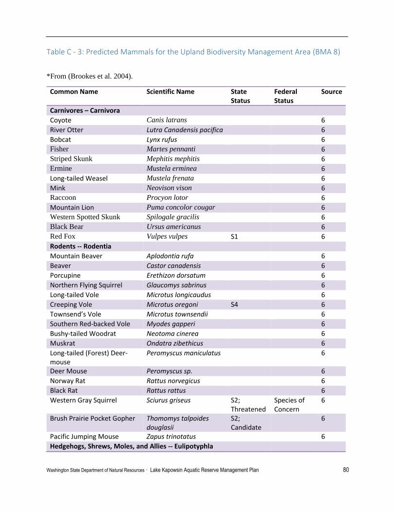
Washington State Department of Natural Resources · Lake Kapowsin Aquatic Reserve Management Plan 80
Table C - 3: Predicted Mammals for the Upland Biodiversity Management Area (BMA 8)
*From (Brookes et al. 2004).
Common Name Scientific Name State Status
Federal Status
Source
Carnivores – Carnivora
Coyote Canis latrans 6
River Otter Lutra Canadensis pacifica 6
Bobcat Lynx rufus
6
Fisher Martes pennanti 6
Striped Skunk Mephitis mephitis 6
Ermine Mustela erminea 6
Long-tailed Weasel Mustela frenata 6
Mink Neovison vison 6
Raccoon Procyon lotor 6
Mountain Lion Puma concolor cougar 6
Western Spotted Skunk Spilogale gracilis 6
Black Bear Ursus americanus 6
Red Fox Vulpes vulpes S1 6
Rodents -- Rodentia
Mountain Beaver Aplodontia rufa 6
Beaver Castor canadensis 6
Porcupine Erethizon dorsatum 6
Northern Flying Squirrel Glaucomys sabrinus 6
Long-tailed Vole Microtus longicaudus 6
Creeping Vole Microtus oregoni S4 6
Townsend’s Vole Microtus townsendii 6
Southern Red-backed Vole Myodes gapperi 6
Bushy-tailed Woodrat Neotoma cinerea 6
Muskrat Ondatra zibethicus 6
Long-tailed (Forest) Deer-mouse
Peromyscus maniculatus 6
Deer Mouse Peromyscus sp. 6
Norway Rat Rattus norvegicus 6
Black Rat Rattus rattus 6
Western Gray Squirrel Sciurus griseus S2; Threatened
Species of Concern
6
Brush Prairie Pocket Gopher Thomomys talpoides douglasii
S2; Candidate
6
Pacific Jumping Mouse Zapus trinotatus 6
Hedgehogs, Shrews, Moles, and Allies -- Eulipotyphla

Washington State Department of Natural Resources · Lake Kapowsin Aquatic Reserve Management Plan 81
Common Name Scientific Name State Status
Federal Status
Source
Mountain Beaver Neurotrichus gibbsii 6
Beaver Scapanus orarius 6
Porcupine Scapanus townsendii 6
Pacific Water Shrew Sorex bendirii S4; Monitored
6
Dusky (Montane) Shrew Sorex monticolus S4 6
Towbridge’s Shrew Sorex trowbridgii 6
Vagrant Shrew Sorex vagrans 6
Bats -- Chiroptera
Townsend’s Big-eared Bat Corynorhinus townsendii S2S3; Candidate
Species of Concern
6
Big Brown Bat Eptesicus fuscus 6
Silver-haired Bat Lasionycteris noctivagans S3 6
Hoary Bat Lasiurus cinereus S3 6
California Myotis Myotis californicus S3S4 6
Long-eared Myotis Myotis evotis S4; Monitored
Species of Concern
6
Little Brown Myotis Myotis lucifugus S3 6
Long-legged Myotis Myotis volans S3S4; Monitored
Species of Concern
6
Yuma Myotis Myotis yumanensis 6
Ungulates -- Artiodactyla
Black-tailed Deer Odocoileus hemionus columbianus
6
Rabbits, Hares, and Allies -- Lagomorpha
Snowshoe Hare Lepus americanus 6
Eastern Cottontail Sylvilagus floridanus 6
Marsupials -- Didelphimorphia
Virginia Opossum Didelphis virginiana 6

Washington State Department of Natural Resources · Lake Kapowsin Aquatic Reserve Management Plan 82
Table C - 4: Invertebrates Observed in Lake Kapowsin
Family Taxon State Status
Federal Status
Source
Annelida
Glossiphoniidae Glossiphoniidae 3
Glossiphoniidae Helobdella stagnalis 3
Naididae Naididae 3
Arthropoda
Chironomidae Ablabesmyia 3
Aeshnidae Aeshnidae 3
Chironomidae Brillia 3
Asellidae Caecidotea 3
Ceratopogonidae Ceratopogonidae 3
Ceratopogonidae Ceratopogonidae 3
Chaoboridae Chaoborus 3
Chironomidae Chironomus 3
Chironomidae Clinotanypus 3
Coenagrionidae Cpemagropmodae 3
Crangonyctidae Crangonyx 3
Hyalellidae Hyalella 3
Libellulidae Libellulidae 3
Limnephilidae Limnephilidae 3
Limnephilidae Limnephilidae 3
Limnephilidae Limnephilus 3
Chironomidae Microtendipes 3
Leptoceridae Oecetis 3
Chironomidae Polypedilum 3
Chironomidae Psectrocladius 3
Chironomidae Tanytarsini 3
Chironomidae Tanytarsus 3
Unknown Amphipoda 3
Mollusca
Viviparidae Cipangopaludina chinesis 3
Physidae Physidae 3
Planorbidae Planorbidae 3
Sphaeriidae Sphaeriidae 3
Nemata
Unknown Nemata 3

Washington State Department of Natural Resources · Lake Kapowsin Aquatic Reserve Management Plan 83
Table C- 5: Vegetation Observed in Lake Kapowsin
Common Name Scientific Name State Status
Federal Status
Source
Aquatic Plants -- Forbes
Northern Water Plantain Alisma triviale 3 Mexican Water Fern Azolla microphylla 3 Watershield Brasenia schreberi 3 Pond Water Starwort Callitriche stagnalis Non-native 3 Coontail; hornwort Ceratophyllum demersum 3 Common Elodea Elodea canadensis 3 Common Duckweed Lemna minor Non-native 3 Water Mudwort Limosella aquatic 3 Water Purslane Ludwigia palustris 3 Common Naiad Najas flexilis 3 Stonewort Nitella sp. 3 Yellow Pond Lilly Nuphar lutea 3 Large-leaf Pondweed Potamogeton amplifolius 3 Ribbonleaf Pondweed Potamogeton epihydrus 3 Whitestem Pondweed Potamogeton praelongus 3 Small Pondweed Potamogeton pusillus 3 Robbins’ Pondweed Potamogeton robbinsii 3 Flatstem Pondweed Potamogeton
zosteriformis 3
Sago Pondweed Stuckenia pectinate 3 Common Bladderwort Utricularia macrorhiza 3 Aquatic Plants – Mosses Water Moss Fontinalis antipyretica 3 Vascular Plants -- Trees Red Alder Alnus rubra 3 Oregon Ash Fraxinus latifolia 3 Oregon Crab Apple Malus fusca 3 Western Red Cedar Thuja plicata 3 Western Hemlock Tsuga heterophylla 3 Vascular Plants -- Shrubs Red-Osier Dogwood Cornus sericea 3 Cascara Buckthorn Frangula purshiana 3 Salal Gaultheria shallon 3 Western Swamp Laurel Kalmia microphylla 3 Bog Labrador Tea Ledum groenlandicum 3 Twinberry Lonicera involucrate 3 Rusty Menziesia Menziesia ferruginea 3 Himalayan Blackberry Rubus armeniacus Non-native;
Class C 3

Washington State Department of Natural Resources · Lake Kapowsin Aquatic Reserve Management Plan 84
Common Name Scientific Name State Status
Federal Status
Source
Evergreen Blackberry Rubus laciniatus Non-native; Class C
3
Geyer Willow Salix geyeriana 3 Coastal Willow Salix hookeriana 3 Sitka Willow Salix sitchensis 3 Hardhack, Rose Spirea Spirea douglasii 3 Common Snowberry Symphoricarpos albus 3 California Huckleberry Vaccinium ovatum 3 Bog Cranberry Vaccinium oxycoccos 3 Vascular Plants -- Forbes Beggarticks Bidens sp. 3 Western Water Hemlock Cicuta douglasii 3 Canada Thistle Cirsium arvense Non-native;
Class C 3
Purple Marshlocks Comarum palustre 3 Smooth Hawksbeard Crepis capillaris Non-native 3 Roundleaf Sundew Drosera rotunifolia 3 Watson Willow Herb Epilobium ciliatum ssp.
Watsonii 3
Water Horsetail Equisetum fluviatile 3 Chamisso’s Cottongrass Eriophorum chamissonis 3 Three-petal Bedstraw Galium trifidum ssp.
columbianum 3
St. John’s Wort Hypericum anagalloides Non-native 3 Pacific Jewelweed Impatiens x pacifica Non-native 3 Yellow Flag Iris Iris pseudoacorus Non-native;
Class C 3
Bird’s-foot trefoil Lotus corniculatus Non-native 3 Northern Bugleweed Lycopus uniflorus 3 American Skunk Cabbage Lysichiton americanus 3 Purple Loosestrife Lythrum salicaria Non-native
Class B 2
Wild Mint Mentha arvensis 3 Seep Monkey Flower Mimulus guttatus 3 Bay Forget-Me-Not Myosotis laxa 3 True Forget-Me-Not Myosotis scorpioides Non-native 3 Watercress Nasturtium officinale Non-native 3 Narrowleaf Plantain Plantago lanceolate Non-native 3 Swamp Smartweed Polygonum
hydropiperoides 3
Curvepod Yellowcress Rorippa curvisiliqua 3 Climbing Nightshade Solanum dulcamara Non-native 3 Common Dandelion Taraxicum officinale Non-native 3
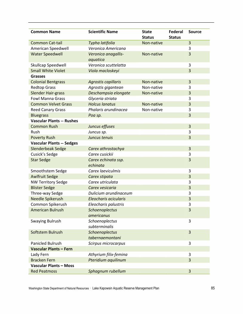
Washington State Department of Natural Resources · Lake Kapowsin Aquatic Reserve Management Plan 85
Common Name Scientific Name State Status
Federal Status
Source
Common Cat-tail Typha latifolia Non-native 3 American Speedwell Veronica Americana 3 Water Speedwell Veronica anagallis-
aquatica Non-native 3
Skullcap Speedwell Veronica scuttelatta 3 Small White Violet Viola macloskeyi 3 Grasses Colonial Bentgrass Agrostis capillaris Non-native 3 Redtop Grass Agrostis gigantean Non-native 3 Slender Hair-grass Deschampsia elongate Non-native 3 Fowl Manna Grass Glyceria striata 3 Common Velvet Grass Holcus lanatus Non-native 3 Reed Canary Grass Phalaris arundinacea Non-native 3 Bluegrass Poa sp. 3 Vascular Plants -- Rushes Common Rush Juncus effuses 3 Rush Juncus sp. 3 Poverty Rush Juncus tenuis 3 Vascular Plants -- Sedges Slenderbeak Sedge Carex athrostachya 3 Cusick’s Sedge Carex cusickii 3 Star Sedge Carex echinata ssp.
echinata 3
Smoothstem Sedge Carex laeviculmis 3 Awlfruit Sedge Carex stipata 3 NW Territory Sedge Carex utriculata 3 Blister Sedge Carex vesicaria 3 Three-way Sedge Dulicium arundinaceum 3 Needle Spikerush Eleocharis acicularis 3 Common Spikerush Eleocharis palustris 3 American Bulrush Schoenoplectus
americanus 3
Swaying Bulrush Schoenoplectus subterminalis
3
Softstem Bulrush Schoenoplectus tabernaemontani
3
Panicled Bulrush Scirpus microcarpus 3 Vascular Plants – Fern Lady Fern Athyrium filix-femina 3 Bracken Fern Pteridium aquilinum 3 Vascular Plants – Moss Red Peatmoss Sphagnum rubellum 3

Washington State Department of Natural Resources · Lake Kapowsin Aquatic Reserve Management Plan 86
Table C - 6: Amphibians predicted or observed to inhabit Lake Kapowsin.
* Predicted to inhabit the Upland Biodiversity Management Area (BMA 8)6
Predicted Hamer Environmental3
◊ Observed by DNR Aquatics and Hamer Environmental L.P. during 2015 visual surveys
Common Name Scientific Name State Status Federal Status
Source
Salamanders and Newts
Northwestern salamander * ◊ Ambystoma gracile S5 3, 5. 6
Long-toed salamander * Ambystoma macrodactylum
S5 6
Pacific giant salamander * Dicamptodon tenebrosus
S5 6
Rough-skinned newt *◊ Taricha granulosa S5 3, 5, 6
Frogs
American bullfrog ◊ Lithobates catesbeianus
Invasive problematic
3, 5
Pacific treefrog (Chorus frog) *◊ Pseudacris regilla S5 3, 5. 6
Northern Red-legged frog *◊ Rana aurora aurora S4; Species of Concern
Species of concern
3, 5, 6
Oregon spotted frog* Rana pretiosa S1; Endangered
Listed Threatened
3(Predicted), 7
Toads
Western Toad * Anaxyrus boreas S3; Candidate
Species of concern
6

Washington State Department of Natural Resources · Lake Kapowsin Aquatic Reserve Management Plan 87
Table C - 7: WDFW Priority Species and Habitat in Lake Kapowsin Area
Kapowsin Creek
Common Name Scientific Name Priority Area/Type Winter Steelhead Oncorhynchus mykiss Occurrence/Migration Steelhead Oncorhynchus mykiss Occurrence Coho Salmon Oncorhynchus kisutch Breeding Area Bull Trout Salvelinus confluentus Occurrence/Migration Chinook Salmon Oncorhynchus tshawytscha Occurrence Fall Chinook Salmon Oncorhynchus tshawytscha Breeding Area Pink Salmon Odd Year Oncorhynchus gorbuscha Occurrence,
Breeding Area
Fall Chum Salmon Oncorhynchus keta Occurrence/Migration Grizzly bear Ursus arctos Occurrence Habitats Freshwater Emergent Wetland Aquatic Habitat Freshwater Forested/Shrub Wetland Aquatic Habitat Waterfowl Concentrations Aquatic Habitat
Refer to WDFW Priority Species and Habitat Program website for more information.

Washington State Department of Natural Resources · Lake Kapowsin Aquatic Reserve Management Plan 88
Appendix D – Maps
Appendix D – Table of Maps
D- 1: Lake Kapowsin Vicinity…………………………………………………… 89
D- 2: Lake Kapowsin Drainage Area…………………………………………….. 90
D- 3: Lake Kapowsin Assumed State-owned Aquatic Lands …………………… 91
D- 4: WDFW Priority Habitats and Species……………………………………... 92
D- 5: Wetland Habitat Areas…………………………………………………….. 93
D- 6: Non-Native Plant Occurrence..…………………………………………….. 94
D- 7: Water Quality and Chemistry Sample Sites……………………………….. 95
D- 8: Northwestern Salamander and Rough-skinned Newt Observations………. 96
D- 9: Pacific Tree Frog and Northern Red-legged Frog Observations…………. 97
D-10: Non-Native Bullfrog Observations……………………………………….. 98
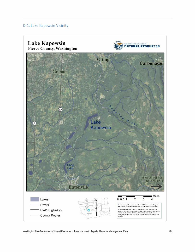
Washington State Department of Natural Resources · Lake Kapowsin Aquatic Reserve Management Plan 89
D-1. Lake Kapowsin Vicinity

Washington State Department of Natural Resources · Lake Kapowsin Aquatic Reserve Management Plan 90
D-2. Lake Kapowsin Drainage Area
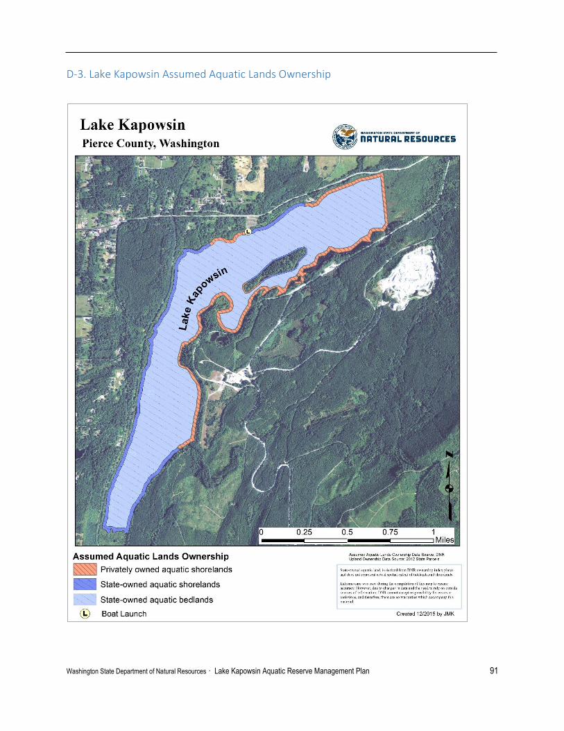
Washington State Department of Natural Resources · Lake Kapowsin Aquatic Reserve Management Plan 91
D-3. Lake Kapowsin Assumed Aquatic Lands Ownership

Washington State Department of Natural Resources · Lake Kapowsin Aquatic Reserve Management Plan 92
D-4. WDFW Priority Habitats & Species

Washington State Department of Natural Resources · Lake Kapowsin Aquatic Reserve Management Plan 93
D-5. Wetland Habitat Areas

Washington State Department of Natural Resources · Lake Kapowsin Aquatic Reserve Management Plan 94
D-6. Non-Native Plant Occurrence

Washington State Department of Natural Resources · Lake Kapowsin Aquatic Reserve Management Plan 95
D-7. Water Quality and Chemistry Sample Sites

Washington State Department of Natural Resources · Lake Kapowsin Aquatic Reserve Management Plan 96
D-8. Northwestern salamander & Rough-skinned newt Observations

Washington State Department of Natural Resources · Lake Kapowsin Aquatic Reserve Management Plan 97
D – 9. Pacific Tree Frog & Northern Red-legged Frog Observations

Washington State Department of Natural Resources · Lake Kapowsin Aquatic Reserve Management Plan 98
D – 10. Non-native American Bullfrog Observations

Washington State Department of Natural Resources · Lake Kapowsin Aquatic Reserve Management Plan 99
Appendix E – Commissioner’s Order

Washington State Department of Natural Resources · Lake Kapowsin Aquatic Reserve Management Plan 100

Washington State Department of Natural Resources · Lake Kapowsin Aquatic Reserve Management Plan 101

Washington State Department of Natural Resources · Lake Kapowsin Aquatic Reserve Management Plan 102