lake) description/location: 2 · amargosa south (incl. part of amargosa river and grimshaw lake)...
TRANSCRIPT

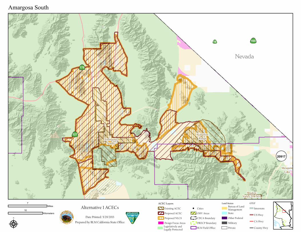
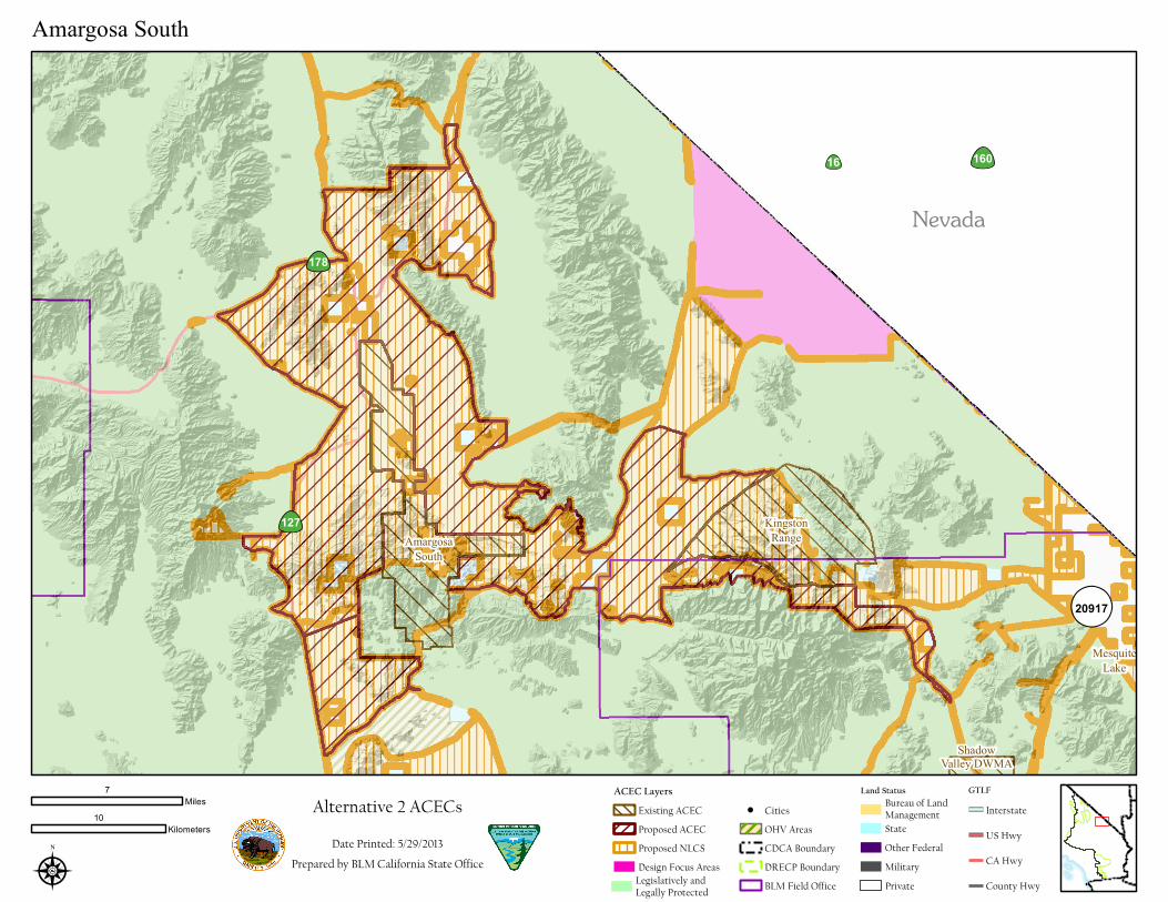
Amargosa South (incl. part of Amargosa River and Grimshaw Lake)
Description/Location: Amargosa South (includes original 2 ACECs areas— part of Amargosa River ACEC and Grimshaw Lake ACEC). This ACEC is between Resting Spring Range Wilderness (to the north), Dumont Dunes to the south (not including the Dunes in this ACEC), Nopah Range Wilderness and the South Nopah Range Wilderness, Ibex Wilderness, Pahrump Valley Wilderness, Death Valley National Park, and to Nevada Stateline. The 26.3 mile Amargosa River Wild and Scenic River designated in the Omnibus Public Land Management Act of 2009 includes 1 wild segment, 2 scenic segments, 2 recreational segments is located within the boundary of the ACEC.
Nationally Significant Values: Ecological: The Amargosa South Unit expansion is marked by permanent flowing water and wetlands in one of the driest desert areas on the continent, and includes a broad range of habitat types, serving as a magnet for a diversity of plant and wildlife species, including many special status species. The area also provides habitat for several narrowly endemic species, some of which may not have been described by scientists. Public lands within this unit provide critical habitat connections between a number of designated BLM wilderness areas. Due to its diverse bird assemblage and habitat significance, this area has been designated a nationally recognized Important Bird Area. This area contains an unusual invertebrate assemblages associated with caves and springs – some species may not have been described yet by scientists.
Cultural: This unit includes some of the most intact viewsheds in the California Desert which protects the historical integrity of tribally significant landscapes, and cultural landscapes associated with the Old Spanish National Historic Trail. The area contains a portion of the Old Spanish National Historic Trail within the Nopah Wilderness known as Emigrant Pass which is in the process of being nominated to the National Register of Historic Places.
Scientific: A long‐term demographic/ habitat assessment study is being conducted in this unit on the Amargosa Vole which is a very narrowly endemic (limited to approximately 18 hectars) remnant from historically wetter times. This unit is also subject of a long‐term hydrology monitoring study.
Special Designations/Management Plan/Date: portions designated in 1984, Amargosa River ACEC Plan (encompassing Grimshaw Lake ACEC) in preparation, expansion is newly proposed.
Relevance and Importance Criteria: Relevant biological resources including wildlife and plant assemblages. The area is critical for bighorn sheep (including connectivity), has a unique plant assemblage of desert grassland, and the area has regionally significant populations of scrub lotus (Acmispon argyraeus var. multicaulis), rosy two‐toned beardtongue (Penstemon bicolor ssp. roseus), cottonwood gallery forest and mesquite bosque. Additionally the area provides important bird habitat for prairie falcons, gray vireo, southwest willow flycatcher, least Bell’s vireo, yellow billed cuckoo and Bendire’s thrasher. The ACEC contains designated critical habitat for the Amargosa vole and occupied habitat for the Amargosa niterwort and provides important habitat for desert tortoise connectivity and the Amargosa pupfish.
The area contains significant historic and prehistoric cultural resources including the Old Spanish National Historic Trail.
Grimshaw Lake ACEC Relevant riparian, wildlife and cultural values. Permanent flowing water and associated wetlands in the Grimshaw Lake Natural Area provide food, cover and nesting space to a great variety of birds. Many fish, mammals, insects and mollusks present in the natural area have very limited distribution or low population number. This water has also attracted humans for the last several thousand years, and the canyon and

surrounding areas offer opportunities for non‐intensive recreation.
Amargosa River ACEC Relevant riparian, wildlife and cultural values. Permanent flowing water and associated wetlands in the Amargosa River ACEC provide food, cover and nesting space to a great variety of birds. Many fish, mammals, insects and mollusks present in the natural area have very limited distribution or low population number. This water has also attracted humans for the last several thousand years, and the canyon and surrounding areas offer opportunities for non‐intensive recreation.
Goals: Protect biological values, including habitat quality, populations of sensitive species, and landscape connectivity while providing for compatible public uses. Protect cultural resources within a landscape setting, to ensure that the environmental context is preserved, especially in association with the Old Spanish National Historic Trail.
Grimshaw Lake ACEC Maintain current condition and extent of wetland habitats in order to preserve sensitive biological resources.
Amargosa Canyon ACEC Protect the area’s sensitive and rare wildlife, riparian and cultural resources, while still providing for non‐intensive recreation. To provide specific administrative guidance for a variety of natural resources present along a small portion of the Amargosa River drainage.
For NLCS Lands ‐‐ Where this ruleset differs from the plan‐wide NLCS rulesets, the more restrictive rules will apply. Designation and Acreage by Alternative:
Alternative BLM Acres of NLCS
within ACEC or Wildlife Allocation
BLM Acres within ACEC
BLM Acres within Wildlife Allocation
ACEC Disturbance Cap
No Action 0 19,500 0 NA
Preferred Alternative
143,000 149,300 0 1%
1 115,000 138,700 0 1%
2 138,700 138,700 0 1%
3 131,700 138,000 0 1%
4 129,600 135,800 0 1%
* Acreage values are for BLM managed lands
Alternatives: All Action Alternatives – The unit will be managed as it has been, but the boundary would be expanded. No Action ‐ Under the no action alternative, the unit would be managed as it has been and there would be no expansion.

Objectives (desired future conditions)/Allowable Uses/Management Actions Resource
Objective: Conserve and protect water resources essential to maintenance of other valued resources and habitats Allowable Uses: Protect ground water by not authorizing withdrawals within the ACEC Management Action 1: Prohibit new non‐administrative, discretionary stream diversions and groundwater‐disturbing activities on public lands within the ACEC Management Action 2: Assert Federal Reserve water rights for Kingston Range Wilderness, the Amargosa Wild and Scenic River and Public Water Reserves Management Action 3: File for appropriated water rights to conserve existing water sources that support the ACEC's resources and values Management Action 4: Install and maintain stream monitoring equipment to quantify flows in the Amargosa Canyon Management Action 5: Monitor surface water quality at pre‐selected locations to gauge condition and trend Management Action 6: Identify, map, and monitor groundwater sources and springs within the ACEC Management Action 7: Monitor water uses from new BLM land use authorizations within the California portion of the Amargosa watershed Objective: Conserve soils and soil properties in the ACEC Objective: Conserve soil resources to maintain other valued resources and habitats Management Action: Conduct an Order III soil survey for the ACEC that will include a series or association level vegetation map for the ACEC Objective: Maintain riparian habitat, permanent water flow through Amargosa Canyon to ensure stability of natural resources dependent upon continued water flow Allowable Uses: Section 33, Township 21 North, Range 7 East: Public water reserve Management Action: Develop projects to prevent degradation of hydrologic resources
Soil, water, air
Objective: Maintain or Improve condition of vegetation Management Action 1: Remove invasive invasive plants, rehabilitate/revegetated disturbed areas Management Action 2: Protect populations of special status plants Amargosa niterwort (Nitrophila mohavensis) Ash Meadows gumplant (Grindelia fraxino‐pratensis) Tecopa bird’s‐beak (Chloropyron tecopense) Amargosa beardtongue(Penstemon fruticiformis var. amargosae) Stephens' beardtongue(Penstemon stephensii) Pahrump orache (Atriplex argentea var. longitrichoma) forked buckwheat (Eriogonum bifurcatum) Kingston Mountains bedstraw (Galium hilendiae ssp. kingstonense) Kingston Mountains ivesia (Ivesia patellifera)
Vegetation – Including special status species
Clark Mountain monardella (Monardella eremicola) Parish's phacelia (Phacelia parishii) Rusby's desert‐mallow (Sphaeralcea rusbyi var. eremicola) Grimshaw ACEC BLM special status species:
‐ Cordylanthus tecopensis ‐ Centarium namophilum ‐ Calochortus striatus ‐ Nitrophila mojavensis
Amargosa Canyon ACEC BLM special status species:
‐ Cordylanthus tecopensis ‐ Centarium namophilum ‐ Calochortus striatus ‐ Nitrophila mojavensis
Management Action 3: Protect Unusual Plant Assemblages: Mesquite bosque Salt and brackish water marshes Cottonwood Gallery Forest/Woodland Objective: Monitor the condition of vegetation to inform adaptive management of vegetation in the ACEC Management Action1: Conduct multi‐year surveys to establish a vegetation baseline in the ACEC, including populations of listed and sensitive plant species Management Action 2: Monitor changes in vegetation over time, once a baseline is established Management Action 3: Monitor suitable listed and sensitive plant habitat Management Action 4: Track population trends Management Action 5: Identify additional recovery needs Management Action 6: Identify thresholds for substantial change that would trigger the reevaluation of conservation strategies Objective: Reduce non‐native riparian plants along the Amargosa River, especially tamarisk Management Action1: Implement the Barstow Field Office's ten‐year weed control plan for tamarisk (Tamarix spp.) in upstream portions of the ACEC first and including public, state, and private lands, as feasible Management Action 2: Implement, as needed, a controlled burn program to enhance weed control projects and/or to eliminate refuse from mechanical removal Management Action 3: Restore riparian zones as needed by reintroducing native riparian plant species in areas of weed control and other priority damaged areas Management Action 4: Design projects to enhance nesting habitat of listed and

candidate bird species based on local bird surveys, literature review of microhabitat requirements, and advice from avian ecologists Management Action 5: Prohibit non‐restoration related fires on public lands within the ACEC Objective: Protect populations and habitats of listed and rare plant species Management Action 1: Maintain existing protective fences Management Action 2: Fence and restore closed vehicle routes Management Action 3: Put in place signs identifying known populations that people or other disturbances are impacting Objective: Maintain riparian habitat quality Management Action: Remove tamarisk from area Objective: Improve riparian habitat Management Action: Remove tamarisk in Natural Area and allow for native plant growth
Objective: Maintain or improve habitat for sensitive wildlife species Management Action: Protect populations of special status animals Amargosa vole Death Valley agabus diving beetle (Agabus rumppi) Shoshone Cave whip‐scorpion (Hubbardia shoshonensis) Death Valley June beetle (Polyphylla erratica) Shoshone Cave harvestman( Texella Shoshone) Amargona naucorid bug (Pelacoris shoshone) Pallid bat Townsend’s big‐eared bat Long‐legged myotis (Myotis volans) Kingston Mountain chipmunk(Neotamias panamintinus acrus) Mojave fringed toed lizard Nelson’s biorhorn sheep Western Yellow‐billed Cuckoo – CDFG listed species Long‐eared Owl – CDFG species of concern Loggerhead Shrike – CDFG species of concern Yellow breasted Chat – CDFG species of concern Bendire’s Thrasher – BLM sensitive species Crissal Thrasher – BLM sensitive species Gray vireo – BLM sensitive species Least Bell’s vireo – federally listed Southwest Willow Flycatcher – federally listed Brown‐crested Flycatcher – CDFG species of concern Vermillion flycatcher – CDFG species of concern Lucy’s Warbler – BLM sensitive species Virginia’s Warbler – CDFG species of concern Yellow warbler – CDFG species of concern Summer Tanager – CDFG species of concern Amargosa pupfish and Shoshone pupfish
Fish and Wildlife – Including special status species

Amargosa River ACEC speckled dace (Rhinichthys osculus ssp. 1) Grimshaw Lake ACEC Special Status Species:
‐ Least Bell’s Vireo ‐ Amargosa vole ‐ Yellow‐billed cuckoo ‐ Amargosa River Pupfish ‐ Speckled Dace
Objective: Protect sensitive species and their habitat by preventing irreparable damage Management Action 1: Reduce the numbers of exotic fauna in habitats of listed species habitats using established protocols to respond to: house mouse (Mus musculus); free‐roaming and/or feral domestic cats; brown‐headed cowbirds; and other species as identified Management Action 2: Repair portions of the Tidewater and Tonopah (T and T) railroad grade that might cause loss of Amargosa vole populations and habitat from Amargosa River flooding where ecologically feasible and economically feasible Management Action 3: Collaborate with the FWS, USGS, and CDFG to
translocate voles to other suitable habitats if repair of railroad potential
problem areas is not reasonable or feasible
Management Action 4: Construct a vehicle barrier at the mouth of Cowboy
Canyon to protect riparian habitat of listed species
Management Action 5: Survey for populations of Amargosa River pupfish
(Cyprinodon nevadensis amargosae) and the Amargosa Canyon speckled dace
(Rhinichthys osculus ssp.1)
Management Action 6: Monitor and evaluate habitat trends and conditions specific to listed species on public lands throughout the ACEC Management Action 7: Work with private landowners, the State, and other federal agencies to identify listed species habitat and habitat trends throughout the ACEC Management Action 8: Inventory invertebrate populations and assemblages in the ACEC associated with caves and springs Management Action 9: Monitor sensitive fish and invertebrate microhabitats to identify trends and threats
Objective: Implement new Wild and Scenic River Trail Plan (under development) Allowable Uses: limited to designated roads and trails, no new routes other than in plan Management Action 1: Maintain existing off‐road vehicle barriers at the southern end of the Amargosa River ACEC adjacent to Sperry Wash to protect wilderness values; support the existing OHV vehicle closure in Amargosa
Trails and Travel Management

Canyon; and to protect listed species and their habitats Management Action 2: Build an OHV exclusion barrier at the trailhead of the rerouted northern end of the Tecopa Trail and restore the previous trailhead, as needed Management Action 3: Close open route in Tecopa Marsh Management Action 4: Continue existing closure around Tecopa (approximately 10,000 acres) Objective: Control vehicle access in Grimshaw Lake ACEC Allowable Uses: OHV limited to designated routes Management Action: Post signs Objective: Control vehicle access to Amargosa Canyon ACEC Allowable Uses: OHV limited to designated routes outside ACEC Management Action: Post signs to block access
Objective: Administer and manage trail resources in accordance with Old Spanish Trail Comprehensive Management Plan, NTSA, FLMPA, local RMPs, and agency policy and direction. Allowable Uses: Research, interpretation, recreation. Management Action: Designate Trail Management Corridor
National Historic Trails
Objective: Administer and manage river resources in accordance with Amargosa Wild and Scenic River Comprehensive Management Plan, NTSA, FLMPA, local RMPs, and agency policy and direction. Allowable Uses: Research, interpretation, recreation. Management Action: Implement WSR management plan
Wild and Scenic Rivers
Refer to the Amargosa/Grimshaw Special Recreation Management Area (SRMA) write‐up for detailed objectives, allocations, and management direction. Objective: Provide dispersed opportunities for enjoyment of the ACEC attributes Allowable Uses: Dispersed camping Objective: Limit OHV impacts on resources at Grimshaw Lake ACEC Allowable Uses: OHV limited to designated routes Management Action: Post interpretive signs along highly used routes Objective: Limit OHV impacts on resources at Amargosa Canyon ACEC Allowable Uses: OHV limited to designated routes Management Action: Post interpretive signs along highly used routes
Recreation
Objective: Acquire all inholdings from willing sellers Management Action 1: Prioritize areas identified in the 1983 ACEC Plans and lands in the expanded ACEC that contain significant resource values Management Action 2: Acquire State and private lands within the ACEC through exchange or purchase from interested, willing landowners to consolidate public lands.
Land Tenure

Objective: Increase protection of sensitive resources present within the Grimshaw Lake ACEC through protective withdrawal of public lands Management Action: Submit request that public lands within the Natural Area be withdrawn from appropriation under the public land laws Objective: Provide for uniform management of wetland habitats in basin through cooperative effort with interested landowners Management Action: Acquire private lands near ACEC that contain standing water/marsh habitat through exchange Objective: Provide for long term management of private and state lands within Amargosa Canyon Management Action: Acquire private and State lands in central canyon area through land exchange, and/or coordinate land management with private and State owners
Objective: Protect resource values Allowable Uses: Exclusion zone for site ROW, okay for linear, no ROW in critical habitat, no ROWs that alter groundwater regimes
Rights of Way (ROW)
Objective: Maintain integrity of large blocks of habitat Allowable Uses: Not an allowable use. Renewable energy development is not compatible with NLCS and ACEC unit values and criteria Geothermal: Area closed to geothermal leasing and development
Renewable Energy
Objective: Protect biological resources Allowable Uses: Closed to all new mineral entry, existing ok. Management Action: Prioritize acquisition of private mines and rehabilitate, closed to mining within Amargosa Canyon ACEC
Locatable Minerals Mineral Materials Non‐energy Leasables

Nevada
16
127
178
160
AmargosaSouth
Expansion
SilurianValley
¬«20917
KingstonRange
ShadowValley
DWMASalt
CreekHills
MesquiteLake
AmargosaSouth
ÆN
Preferred Alternative ACECsDate Printed: 5/29/2013
Prepared by BLM California State Office
7.5Miles
10Kilometers
Amargosa South
GTLFInterstateUS HwyCA HwyCounty HwyBLM Field Office
CDCA BoundaryDRECP Boundary
CitiesOHV Areas
ACEC Layers
Proposed NLCSProposed ACECExisting ACEC
Legislatively andLegally ProtectedDesign Focus Areas
State
PrivateMilitary
Land Status
Other Federal
Bureau of LandManagement
Nevada
16
127
178
160
¬«20917
KingstonRange
ShadowValley DWMA
MesquiteLake
AmargosaSouth
ÆN
Alternative 1 ACECsDate Printed: 5/29/2013
Prepared by BLM California State Office
7Miles
10Kilometers
Amargosa South
GTLFInterstateUS HwyCA HwyCounty HwyBLM Field Office
CDCA BoundaryDRECP Boundary
CitiesOHV Areas
ACEC Layers
Proposed NLCSProposed ACECExisting ACEC
Legislatively andLegally ProtectedDesign Focus Areas
State
PrivateMilitary
Land Status
Other Federal
Bureau of LandManagement
Nevada
16
127
178
160
¬«20917
KingstonRange
ShadowValley DWMA
MesquiteLake
AmargosaSouth
ÆN
Alternative 2 ACECsDate Printed: 5/29/2013
Prepared by BLM California State Office
7Miles
10Kilometers
Amargosa South
GTLFInterstateUS HwyCA HwyCounty HwyBLM Field Office
CDCA BoundaryDRECP Boundary
CitiesOHV Areas
ACEC Layers
Proposed NLCSProposed ACECExisting ACEC
Legislatively andLegally ProtectedDesign Focus Areas
State
PrivateMilitary
Land Status
Other Federal
Bureau of LandManagement

Nevada
16
127
178
160
¬«20917
KingstonRange
ShadowValley
DWMASalt CreekHills
MesquiteLake
AmargosaSouth
ÆN
Alternative 3 ACECsDate Printed: 5/29/2013
Prepared by BLM California State Office
7.5Miles
10Kilometers
Amargosa South
GTLFInterstateUS HwyCA HwyCounty HwyBLM Field Office
CDCA BoundaryDRECP Boundary
CitiesOHV Areas
ACEC Layers
Proposed NLCSProposed ACECExisting ACEC
Legislatively andLegally ProtectedDesign Focus Areas
State
PrivateMilitary
Land Status
Other Federal
Bureau of LandManagement

Silurian ValleyCorridor
KingstonRangeAmargosa
South
Nevada16
178
127
160
KingstonRange
AmargosaSouth
N
Alternative 4 ACECsDate Printed: 8/6/2014
Prepared by BLM California State Office
5.5Miles
8Kilometers
Amargosa South
GTLFInterstateUS HwyCA HwyCounty Hwy
Proposed Wildlife Allocation
ACEC Layers
Proposed NLCSExisting ACEC
Legislatively andLegally Protected
Proposed ACEC
BLM Field Office
CDCA BoundaryDRECP Boundary
OHV Areas
Design Focus AreasVariance Lands
Land Status
State
PrivateMilitaryOther Federal
Bureau of LandManagement

127
178
KingstonRangeAmargosa
South
ÆN Date Printed: 5/29/2013
Prepared by BLM California State Office
3.5Miles
5Kilometers
Amargosa South
GTLFInterstateUS HwyCA HwyCounty Hwy
State
PrivateMilitary
Land Status
Other Federal
Bureau of LandManagement
ACEC LayersExisting ACEC
Legislatively andLegally Protected BLM Field Office
CDCA BoundaryDRECP Boundary
Cities
OHV Areas