lagos state mapping/gis project technical proposalphoto... · bidding ref: 2083719110 modules 1a-c...
TRANSCRIPT

LAGOS STATE MAPPING/GIS PROJECT Components 1 A-C
Executive Governor’s Office Office of The Surveyor General of Lagos State 133 Obafemi Awolowo Way Ikeja, Lagos, Nigeria
Interspatial Technologies (Nig) Limited | P.O. Box 11652 | Ikeja, Lagos, Nigeria Telephone: +234 802 319 4930 or +2454 1 401 2677
Bidding Reference No: 2083719110
Technical Proposal
Interspecial (K) Limited

This document contains information proprietary to Interspatial Technologies (Nig) Limited. Transmittal, receipt, or possession of this document does not express license, or imply rights to sell, design, manufacture, or have
manufactured from this information.
Copyright © 2012 Interspatial Technologies (Nig) Limited All Rights Reserved
All trademarks referred to in this document belong to their licensed and/or registered owners
Lagos State Digital Mapping & Enterprise GIS
State Mapping/GIS project – Module 1A-C- Controls & Imagries 3
Table of Contents Introduction 1 Project area description .............................................................. 2 1.0 Airborne survey equipment ........................................... 5 2.2 LiDAR sensor ............................................................ 7 2.3 Digital aerial camera .................................................. 9 3.0 Ground control, Georeference and Geodetic
datum ................................................................... 10 3.1 Ground Control Points (GCPs) from the new
Geodetic Network ..................................................... 10 3.2 Ground Control established by PHB for airborne
surveys .................................................................. 12 4.0 Airborne LiDAR survey ............................................... 15 4.1 Flight missions ......................................................... 15 4.2 Post processing of the LiDAR data .................................. 18 5.0 Acquisition of digital aerial color photographs ................... 20
6.0Georeference and Aerotriangulation of digital aerial photographs 28 6.1 Image import and georeference assignment to the
imagery ................................................................. 28


Introduction On April 21st, 2008, Lagos State Government, namely the State Tenders Board, mandated Interspatial Technologies (Interspatial) to realize the GIS / DIGITAL MAPPING Project covering the entire State of Lagos and deliver the upward geodetic / cartographic data and geomatic products in a professional manner. The GIS / DIGITAL MAPPING Project consists of three (3) modules, each relating to distinct and concise professional services as follows:
Module 1, Con.12/2008/76: GEODETIC CONTROL, SIGNALIZATION AND ACQUISITION OF AERIAL PHOTOS
Interspatial is the official contractor and is responsible for all aspects of the overall project. Interspatial is managing and coordinating all phases of the project and is the sole liaison to the Lagos State Government for contractual, technical and legal issues related to the project.
Moreover, Interspatial conducted the geodetic control and realized the signalization of the GCPs (Ground Control Points) with its local technical staff and equipment.
Interspatial accomplished the final compensation of the new established geodetic network composed of 1st order and 2nd order permanent geodetic monuments. Interspatial also realized the transformation of the network to the WGS84 (World Geodetic System 1984) the most widely used global reference system, mainly by GPS surveys and elevation reference to EGM08 (Earth Gravitational Model 2008). Further transformations have been conducted by Interspatial in referencing the network elevations to the local orthometric vertical datum, and referencing the network coordinates to the nationally recognized MINNA Datum.
PERRON HUDON BELANGER Inc. (PHB), a proud member of Interspatial’s technical team, is responsible to Interspatial for its rendered professional services, namely the airborne surveys and the derivative data and products. PHB responds directly to the project manager of Interspatial in Lagos and complies with its stipulated technical and organizational directives and delivery priorities.
For the airborne surveys, PHB has mobilized a twin engine aircraft with highly sophisticated sensor equipment and has contributed to all three (3) Modules of the overall project as follows:
Module 1, ACQUISITION OF AERIAL PHOTOS: PHB acquired a georeferenced stereoscopic coverage of the entire project area with digital aerial photography at 7cm GSD (Ground Sampling Distance). PHB has developed all acquired digital photographs, selected a complete stereoscopic set and accomplished the aerotriangulation of the images covering the landmass, based on the supplied ground control from Interspatial. The results of the aerotriangulation process are the final orientation parameters of the individual photos that cover the landmass

Bidding Ref: 2083719110 Modules 1A-C
Lagos State Mapping/GIS project – Aerial Photo Acquisition - Final Report
2
within the project area. These orientation parameters are essential for precise topographic mapping and the rectification of the individual aerial photos that enter into the orthophoto mapping process, using DPWs (Digital Photogrammetric Workstations) and the related digital photogrammetric software.
Module 3, DTM / ORTHOPHOTO DIGITAL MAPPING: PHB has acquired georeferenced LiDAR (Light Detection And Ranging) throughout the project area with an average density of 1.28 points/m². PHB has examined, classified and processed the LiDAR data to distinguish clearly the bare earth data and the uppermost surface. The bare earth data is the relevant input data for the densification process of the DTM (Digital Terrain Model) and the eventual automatic generation of the elevation contours. Based on the bare earth LiDAR data and the final orientation parameters of each photograph, PHB has rectified the photos and assembled a seamless orthophoto coverage of the entire project area.
Project area description Lagos State is located in the low lands of south-western Nigeria where the ground relief rises from sea level to its highest elevation of approximately 80m ASL (Above Sea Level) at the northern limit of the project area. On this stretch of the high-rainfall West African coast, rivers flowing to the sea form swampy lagoons like Lagos Lagoon and Lekki Lagoon behind long coastal sand spits or sand bars.
The perimeters of Zones A, B and C cover the entire territory of Lagos State, while the entire land cover of Zone D is located within the neighboring State of Ogun, it covers most part of the northern overspill of the Lagos metropolitan area.
The Lagos State Government definitely requires new topographic maps and a comprehensive, well operational GIS for City planning, management infrastructure, environmental investigations and studies, general urban planning, etc.
Following are some relevant statistics from the Lagos State website: Although Lagos state is the smallest state in Nigeria, with an area of 356,861 hectares of which 75,755 hectares are wetlands, yet it has the highest population, which is over five per cent of the national estimate. The state has a population of 17 million out of a national estimate of 150 million. The UN estimates that at its present growth rate, Lagos state will be third largest mega city the world by Y2015 after Tokyo in Japan and Bombay in India. Of this population, Metropolitan Lagos, an area covering 37% of the land area of Lagos State is home to over 85% of the State population. The rate of population growth is about 600,000 per annum with a population density of about 4,193 persons per sq. km. In the built-up areas of Metropolitan Lagos, the average density is over 20,000 persons per square km.

Bidding Ref: 2083719110 Modules 1A-C
Lagos State Mapping/GIS project – Aerial Photo Acquisition - Final Report
3
Source: http://www.lagosstate.gov.ng/index.php?page=subpage&spid=12&mnu=null: The overall project area covers 4128 km² and is broken up into four (4) sub-zones, as shown on following indexes:
Total overall area (including water bodies): 4128 km² Rural Area A: 452 km² Urban Area B: 965 km² Rural Area C, true ground surface (excluding water bodies): 1691 km² Urban Area D: 415 km²
Note: The indicated surface 1691 km² within zone C represents true land cover, the water bodies (Lagos Lagoon 365km² + Lekki Lagoon 240km²) are excluded from the respective overall area encompassed by its perimeter.
The Urban Area D (415km²) covers mainly the urban encroachment of the northern outskirts of Lagos into the neighboring State of Ogun.

Bidding Ref: 2083719110 Modules 1A-C
Lagos State Mapping/GIS project – Aerial Photo Acquisition - Final Report
4
Following index shows the project area on Google Earth background:

Bidding Ref: 2083719110 Modules 1A-C
Lagos State Mapping/GIS project – Aerial Photo Acquisition - Final Report
5
1.0 Airborne survey equipment This section covers the descriptions of the aircraft, the digital camera and the LiDAR sensor with their respective peripherals that has been used to acquire the airborne data, such as the georeferenced digital aerial color photography and the georeferenced airborne LiDAR data.
In addition to the detailed descriptions of the equipment, the relevant technical specifications, permits and calibration reports are attached to the summary report in form of Appendices.

Bidding Ref: 2083719110 Modules 1A-C
Lagos State Mapping/GIS project – Aerial Photo Acquisition - Final Report
6
1.1 Aircraft All airborne survey operations have been executed aboard a Piper Navajo (C-GIPV) twin engine survey aircraft as shown hereafter:

Bidding Ref: 2083719110 Modules 1A-C
Lagos State Mapping/GIS project – Aerial Photo Acquisition - Final Report
7
2.2 LiDAR sensor The airborne LiDAR survey was accomplished with an ALTM Gemini (Airborne Laser Terrain Mapper), S/N 07SEN209; 07CON209, manufactured by OPTECH, Canada. The georeference of the sensor data is detected and recorded through the POSAV 510 that is coupled to the LiDAR sensor.
Following illustrations show the ALTM Gemini sensor with its peripherals:
This LiDAR sensor has a laser repetition rate ranging from 33 – 167 kHZ and can be operated in altitudes from 150m to 4,000m. Both, the LiDAR sensor and the

Bidding Ref: 2083719110 Modules 1A-C
Lagos State Mapping/GIS project – Aerial Photo Acquisition - Final Report
8
GPS/IMU device are coupled and operated simultaneously during the airborne LiDAR survey.
Please consult Appendices 3 & 4 showing the manufacturer’s specifications relative to the POSAV 510 GPS/IMU device and the ALTM Gemini 167 sensor, as follows:
Appendix-3: (App-03_POSAV_specs.pdf) shows the manufacturers specifications for the POSAV 510 GPS/IMU device (please refer to specifications outlined in red);
Appendix-4: (App-04_ALTM-Gemini167_specs.pdf) shows the manufacturers specifications for the ALTM Gemini 167 sensor;
The LiDAR survey has been concluded during two (2) separate missions, therefore two (2) calibration reports are included in this report, as follows:
Appendix-5a: (App-05a_ALTM-Gemini167_Performance_Report_20071115.pdf) shows the detailed calibration and manufacturer’s delivery report, issued Nov. 15, 2007 by OPTECH Inc., Canada. This calibration report refers to the 1st airborne LiDAR survey mission that was accomplished in the spring of 2009, particularly in April - May 2009;
Appendix-5b: (App-05b_ALTM-Gemini167_Calib-Report_20090105.pdf) shows the detailed calibration report, issued Jan. 5, 2009 by OPTECH Inc., Canada. This calibration report refers to the 2nd airborne LiDAR survey mission that was accomplished in the spring of 2009, particularly in March - April 2009;

Bidding Ref: 2083719110 Modules 1A-C
Lagos State Mapping/GIS project – Aerial Photo Acquisition - Final Report
9
2.3 Digital aerial camera The aerial photographs have been acquired with a large format digital aerial camera, the UltraCamD (UCD) model manufactured by Vexcel Imaging GMBH, Austria. The georeference of the photographs was assured through the simultaneous operation of the POSAV 410 direct georeferencing device with the camera, by recording position and orientation corresponding to each image acquisition event.
Following illustrations show the UltraCamD (UCD) Camera with Phripherals:

Bidding Ref: 2083719110 Modules 1A-C
Lagos State Mapping/GIS project – Aerial Photo Acquisition - Final Report
10
Please consult Appendices 3 & 6 showing the manufacturer’s specifications relative to the POSAV 410 GPS/IMU device and the digital camera UltraCamD (UCD) model, as follows:
Appendix-3: (App-03_POSAV_specs.pdf) shows the manufacturers specifications for the POSAV 410 GPS/IMU device (please refer to specifications outlined in red);
Appendix-6: (App-06_UltracamD_UCD_brochure-specs.pdf) shows the highlights and the manufacturers specifications for the digital camera, the Vexcel UltraCamD model;
The aerial photography acquisition covering the entire project area has been concluded in the spring 2009. Following detailed calibration report governs all acquired photos for the Lagos State mapping project:
Appendix-7: (App-07_UCD_Calib-Report_detailed_20090115.pdf) shows the detailed calibration report, issued Jan. 15, 2009 by Vexcel Imaging Gmbh., Austria.
3.0 Ground control, Georeference and Geodetic datum
3.1 Ground Control Points (GCPs) from the new Geodetic Network
Under the supervision of Interspatial, local survey teams have established a new 1st order geodetic network that is covering the entire State of Lagos. Moreover, a supplementary 2nd order geodetic network has been established in the city core.
Some 180 monuments of the 1st order network and another 198 monuments of the 2nd order network have been targeted by cross shaped concrete legs, where the actual monument is installed on a central pillar that rises approximately 40cm above the surrounding ground surface. These targeted monuments have been measured during the aerotriangulation process as described under paragraph 5 on this document.
Furthermore, the survey teams attempted to determine the coordinates for twelve (12) additional GCPs at located at the northern perimeter of Zone-D, and at the most easterly perimeter of Zone-C (Lekki Lagoon). The field crews succeeded to survey only four (4) of these additional GCPs, namely points A-3, A-4, A-5 and A-7. The remaining requested additional GCPs could be surveyed due to prevailing unrests that persisted in these areas during the planned field missions; operations in these areas would have exposed the teams to sever danger.
Appendix-8: (App-08_EGM08_WGS84_Ortho-Elev_summary.xls) showing the coordinates of the geodetic network.

Bidding Ref: 2083719110 Modules 1A-C
Lagos State Mapping/GIS project – Aerial Photo Acquisition - Final Report
11
Index showing in red, the targeted monuments of the 1st order geodetic network, and the four (4) additional control points in light purple (A-3, A-4, A-5 & A-7), that have contributed as GCPs to the aerotriangulation. Note: A-1, A-2, A-6, A-8 to A-12 could not be surveyed.
Index on right is showing the City core of Lagos.
Red color shows the targeted monuments
of the 1st order geodetic network.
Yellow color shows the targeted
monuments of the 2nd order geodetic
network.

Bidding Ref: 2083719110 Modules 1A-C
Lagos State Mapping/GIS project – Aerial Photo Acquisition - Final Report
12
Index showing the leveling network:
3.2 Ground Control established by PHB for airborne surveys GPS Base Stations:
PHB established two (2) control points at the airport that served as base stations, commonly called GPS Base Station, which served for the DGPS observations during all airborne surveys for the purpose of georeferencing the LiDAR data as well as the digital images as shown on following illustration:
The coordinates of these two (2) GPS Base Stations are as follows:
GPS Base Stations surveyed in 2008 Shown in yellow on above index
Point ID Latitude (DD MM
SS/10000)
Longitude (DD MM
SS/10000)
Elev. (m) (ITRF05)
PHB_GPS-1 PHB_GPS-2
3 19 58.45300 3 19 58.74530
6 35 42.04240 6 35 42.16740
62.131 62.048

Bidding Ref: 2083719110 Modules 1A-C
Lagos State Mapping/GIS project – Aerial Photo Acquisition - Final Report
13
Test Site for Bore site calibration related to photo acquisition:
PHB also established fourteen (14) ground control points in 2008 and additional eight (8) points in 2009 on the Lekki Peninsula. Some of the points established have been destroyed; therefore, it was necessary to establish additional control points in 2009. These control points served for the calibration bore site of the camera peripheral instrumentation, a fundamental procedure to attain precise georeference of the newly acquired aerial photography. This zone is identified as the test site t is shown on following illustration:

Bidding Ref: 2083719110 Modules 1A-C
Lagos State Mapping/GIS project – Aerial Photo Acquisition - Final Report
14
Following are the coordinates of the test-site control points: Control points surveyed in 2008
Shown with circles on above index Control points surveyed in 2009
Shown with squares on above index
Pt_ID UTM X UTM Y Z (EGM08) Pt_ID UTM X UTM Y Z
(ITRF05) 310 311 312 313 314 315 316 317 318 319 320 321 323 324
552487.401 552502.365 551869.509 551860.043 551258.279 551287.942 551230.501 551866.264 552492.163 551873.618 551622.616 551603.293 551225.864 552492.935
711470.828 711304.409 711482.275 711294.005 711468.705 711294.611 711577.670 711569.496 711574.115 711888.857 711478.555 711298.131 711895.278 711885.086
3.461 3.370 3.227 5.869 2.462 2.926 5.674 3.438 6.075 2.909 5.826 5.289 2.934 5.803
4100 4101 4102 4103 4104 4105 4106 4107 4108 4109 4110
551612.925 551621.133 551613.086 552164.115 552226.887 552146.072 552100.993 550819.600 550819.687 550704.896 550705.033
711683.852 711717.466 711715.877 712161.268 712245.803 711281.225 711387.531 712163.462 712211.736 711386.357 711353.046
25.313 25.170 25.245 24.864 24.924 25.770 25.697 25.139 25.297 24.952 25.017

Bidding Ref: 2083719110 Modules 1A-C
Lagos State Mapping/GIS project – Aerial Photo Acquisition - Final Report
15
4.0 Airborne LiDAR survey 4.1 Flight missions
The airborne LiDAR survey has been concluded in two (2) major missions, each consisting of several flights spread over many different days, when meteorological conditions permitted optimal data acquisition.
The 1st mission was concluded in the period between late April and mid-May 2008, the surveyed flight lines are shown in orange color on index below.
The 2nd mission was concluded in the period between late March and April 2009, the surveyed flight lines are shown in purple color on index below.
Index showing the surveyed LiDAR flight lines, the two (2) GPS Base Stations in yellow at Lagos Murtala Muhammed International Airport, and the seven (7) LiDAR calibration sites in green:
Following parameters governed the airborne LiDAR survey: Aircraft: Piper Navajo (C-GIPV) twin engine aircraft Flight height (Above Ground Level): 1500m AGL Flight speed: 71m/sec Laser pulse repetition rate: 100,000 Hz Scan pattern angle and rate: +/- 20 / 37Hz Laser footprint on the ground: 30 cm Forward / Lateral spacing: 0.96m / 0.81m Number of returns per shot collected: First and last and intensity Swath width: 1092 m Swath overlap / Line spacing: 30% / 764 m

Bidding Ref: 2083719110 Modules 1A-C
Lagos State Mapping/GIS project – Aerial Photo Acquisition - Final Report
16
Flight preparation:
Prior to takeoff, we ensured that the time frames of our missions have been accomplished during periods when the geometrical strength of the GPS satellite configuration will be most adequate, thus when PDOP values are preferably most minimal, and when prevailing metrological conditions have been favorable. Moreover, survey flights along ocean shores have been conducted during low tide periods.
Following are samples of our flight planning recordings that have been conducted before every takeoff for the airborne LiDAR survey, as well as for the aerial photo acquisition missions.
Graph showing the GPS configuration

Bidding Ref: 2083719110 Modules 1A-C
Lagos State Mapping/GIS project – Aerial Photo Acquisition - Final Report
17
Graph showing PDOP values Flight, airborne survey and related field operations: LiDAR data was acquired over one of the seven (7) LiDAR calibration sites that permitted to accomplish the routine QC/QA procedures that have been concluded after each daily mission.
Flight configuration over a LiDAR calibration site; the small inset shows one
the LiDAR calibration sites on Google Earth background. A further daily routine QC/QA procedure consisted to verify the point cloud density, to assure that the point density respected the prescribed specifications.
Screen display showing calculated point cloud density, in above case the density is
0.968 points / m²
Bidding Ref: 2083719110 Modules 1A-C
Lagos State Mapping/GIS project – Aerial Photo Acquisition - Final Report
18
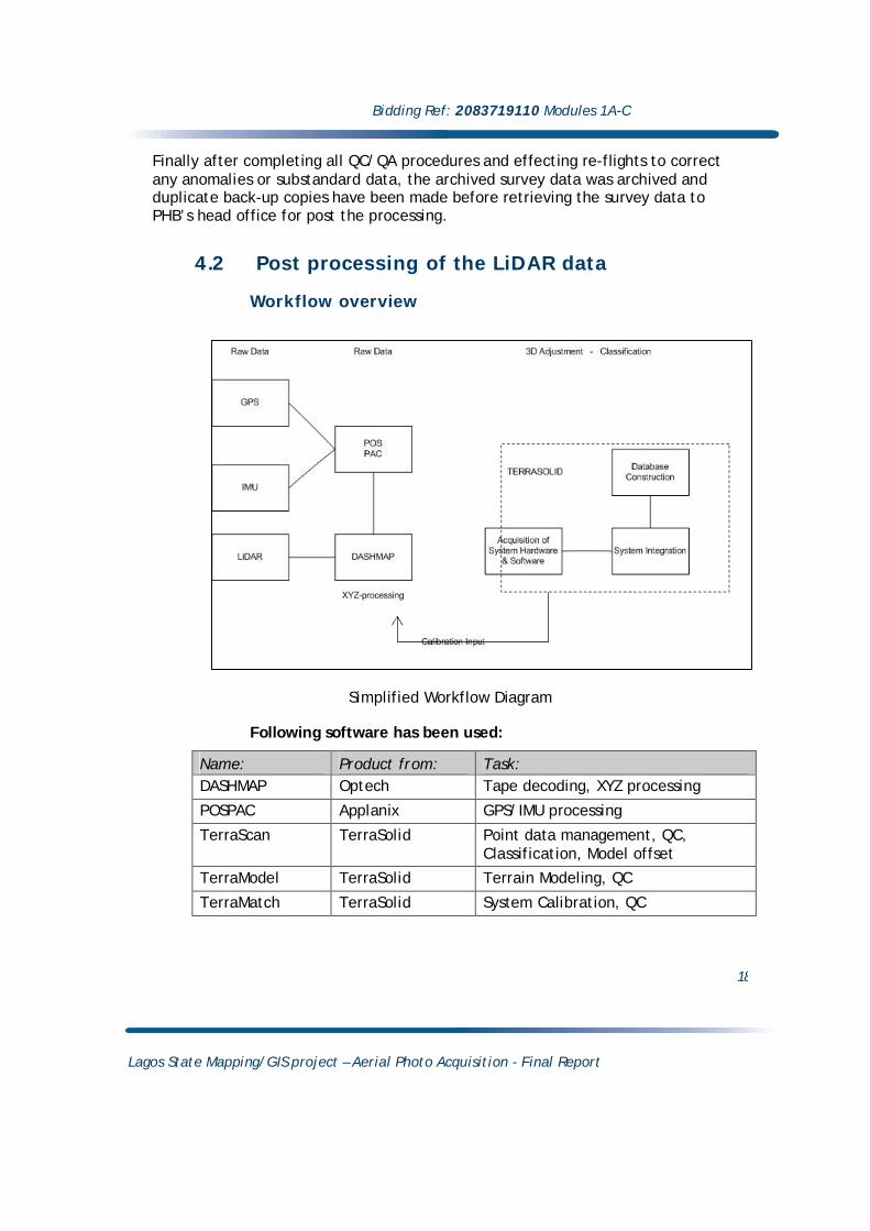
Finally after completing all QC/QA procedures and effecting re-flights to correct any anomalies or substandard data, the archived survey data was archived and duplicate back-up copies have been made before retrieving the survey data to PHB’s head office for post the processing.
4.2 Post processing of the LiDAR data Workflow overview
Simplified Workflow Diagram
Following software has been used:
Name: Product from: Task: DASHMAP Optech Tape decoding, XYZ processing
POSPAC Applanix GPS/IMU processing
TerraScan TerraSolid Point data management, QC, Classification, Model offset
TerraModel TerraSolid Terrain Modeling, QC
TerraMatch TerraSolid System Calibration, QC

Bidding Ref: 2083719110 Modules 1A-C
Lagos State Mapping/GIS project – Aerial Photo Acquisition - Final Report
19
Post processing Systematic errors such as Roll, Pitch and Yaw have been are detected first, using TerraSolid utilities. The result was reset to the final XYZ process in Dashmap. TerraMatch was used to estimate the random errors in delta height, pitch and roll for all stripes, and corrected and adjusted accordingly. TerraScan was used to classify the point cloud, where the Bare Earth data is separated from the uppermost points, the DSM (Digital Surface Model). The Bare Earth data, commonly called the DTM (Digital Terrain Model) is the three-dimensional will ultimately be used in orthophoto mapping process and most importantly for the automatic generation of the elevation contours that shall portray most adequately the ground relief. However, we emphasis that break lines from the eventual three-dimensional stereo compilation of the photogrammetric mapping process are an important input to enhance the LiDAR derived DTM, which will result in contours that will portray the ground relief more truly in areas of abrupt slope changes, such as bottom of valleys (thalweg) top and bottom of embankments, etc.
QC/QA assurance Our quality control confirms that the accuracy of the Bare Earth DTM that is derived from the final LiDAR data is well within the expected specifications. We have found vertical discrepancies that are mostly less than 10cm, by comparing to the established GCPs of the geodetic network, the surveyed calibration profiles and to photogrammetric stereo checks with the aerotriangulated aerial photography.

Bidding Ref: 2083719110 Modules 1A-C
Lagos State Mapping/GIS project – Aerial Photo Acquisition - Final Report
20
5.0 Acquisition of digital aerial color photographs
5.1 Project overview and imagery concepts Over 50,000 digital aerial photographs have been acquired to assure the stereoscopic coverage of the entire project area. The large format UltraCamD digital multispectral camera that provides large format photogrammetric panchromatic, color and color NIR (near-infrared) images was used to acquire the photographs. The onboard installation was combined with a SOMAG gyro stabilized mount, TRACKAIR flight management system and an APPLANIX POSAV system. The camera been calibrated by Vexcel GMBH in Graz, Austria on January 15, 2009, shortly before this particular mission; Appendix-7 shows the detailed calibration report.
Following index shows in light blue the flight lines of the entire photo acquisition mission, in yellow the GPS Base Stations at Lagos Murtala Muhammed International airport, and in purple the Test site used for Bore site calibration:
Following are the parameters that governed the aerial photo acquisition using the VEXCEL UltraCamD camera: Aircraft: Piper Navajo (C-GIPV) twin engine aircraft Flight height: 800m AGL (Above Ground Level); Flight speed: 71m/sec Focal Length: Nominal focal length = 100mm; Overlap: 60% = 213.0m forward overlap, 30% = 571.6m lateral overlap; Pixel size: 7 cm GSD (Ground Sampling Distance); Image size: 532.5m (forward) by 816.6m (lateral)

Bidding Ref: 2083719110 Modules 1A-C
Lagos State Mapping/GIS project – Aerial Photo Acquisition - Final Report
21
5.2 Imagery concept The camera is equipped with a total of eight (8) lenses (figure on left below), where the four (4) panchromatic lenses of the master cone acquire nine (9) images at full resolution (figure right below). The panchromatic resolution is 7cm GSD in the case of this project. The four (4) remaining lenses, the 4 color cones acquire the RGB (Red, Green, Blue) and the 4th lens acquires the NIR (Near Infra Red) image. The images acquired by the color cones serve ultimately the pan-sharpening process of the panchromatic images to achieve the desired color images.
It is important to understand that the large format digital aerial frame images are created from multiple smaller “tiles” or “facets”. The internal geometry of the resulting image may thus be described by rigid rectangular that are geometrically connected by a geometric transformation, typically in the form of a rotation and translation, sometimes as a conformal transformation, sometimes as a projective transformation. This entire procedure is commonly called “stitching”; it is an automatic process that is based on the internal calibration parameters of the camera. The UltraCam system operates with following data levels:
Level-00 Raw data, each triggered image consists of 13 sub-images; stored twice.
Level-0 Verified data, same as Level-00, but no duplicate copy exists
Level-1 Internal intermediate format, maintained as 13 sub-images, but radiometrically corrected using calibration files.
Level-2 Panchromatic images; the sub-images are stitched and geometrically corrected using the calibration files. The four color channels are in one file, separate from the panachromatic data. Color remains at its input resolution, but is geometrically matched to the panchromatic image. Data are in 16 bits per channel (5 channels)
Level-3 Pan-sharpened color images in RGB, CIR or RGB-NIR, 16 bits in TIFF format.

Bidding Ref: 2083719110 Modules 1A-C
Lagos State Mapping/GIS project – Aerial Photo Acquisition - Final Report
22
UltraCamD with its 8 lenses Tiling scheme of the 4 panchromatic cones
Illustration showing the camera lenses and the panchromatic tiling scheme
Workflow Digital workflow
Simplified Workflow Diagram

Bidding Ref: 2083719110 Modules 1A-C
Lagos State Mapping/GIS project – Aerial Photo Acquisition - Final Report
23
Boresite calibration Upon installation of the camera and its peripherals, a calibration flight is initiated by acquiring a stereo coverage over the test site. The calibration parameters are calculated by the boresite calibration software CALQC from Applanix, based on the observed GCPs that are visible on the acquired images. This calibration procedure is repeated at several occasions throughout the overall mission to assure the aimed georeference accuracy. Following displays one of the boresite calibration reports: Calibration Report ======================= Project Name: 056-1 Processing Path: F:\Projets\Nigeria\Sessions\056-1\POSPAC\0561\056-1\CalQC Camera Type: Ultra Cam D Date: 4/23/2009 Time: 9:18:26 AM Project Configuration ========================== Number of photos: 46 Number of strips: 6 Number of GCPs: 21 Number of Check Points: 0 Number of tie/pass pts: 731 Degrees of freedom: 4138 Focal length(mm): 101.400 Principal Point Offset in x(mm): -0.270 Principal Point Offset in y(mm): 0.180 Image measurement x_SD(mm): 0.009 Image measurement y_SD(mm): 0.009 Minimum Ground Parallax(Meter): 0.001 Maximum Ground Parallax(Meter): 0.222 Kappa Cardinal Rotation(Deg): -90.000 Nominal Photo Centre SD(Meter): 0.050 0.050 0.050 Nominal IMU Angle SD(Deg): 0.008 0.008 0.015 Nominal GCP SD(Meter): 0.200 0.200 0.200 Boresight Angles(Arcmin): -8.030 3.174 1.717 Calibration Result ======================= Number of Iterations: 3 RMS of GCP Residuals(Meter): 0.128 0.069 0.095

Bidding Ref: 2083719110 Modules 1A-C
Lagos State Mapping/GIS project – Aerial Photo Acquisition - Final Report
24
RMS of Check Points Residuals(Meter): N/A Datum Shift X,Y and Z(Meter): N/A N/A -0.055 RMS of image coord residuals(mm): 0.003 0.004 RMS of Ground Parallax(Meter): 0.040 RMS of Photo centre residuals(Meter): 0.00913031 0.00786327 0.0224753 RMS of Photo Angular residuals(Deg): 0.00393471 0.00361516 0.00520182 RMS of IMU residuals(Arcmin): 0.236 0.217 0.312 Focal length(mm): 101.400 Principal Point Offset in x(mm): -0.270 Principal Point Offset in y(mm): 0.180 Boresight Angles(Arcmin): -8.044 3.172 1.720 Ground Points Residuals ============================ Point ID X(Meter) Y(Meter) Z(Meter) RX(Meter) RY(Meter) RZ(Meter) 4100 551612.925 711683.852 25.313 -0.226 0.057 0.041 4101 551621.133 711717.466 25.170 -0.158 0.026 0.095 4103 552164.115 712161.268 24.864 -0.065 -0.096 0.041 4106 552100.993 711387.531 25.697 -0.054 -0.044 -0.001 4107 550819.600 712163.462 25.139 -0.095 0.078 0.076 4109 550704.896 711386.357 24.952 N/A N/A N/A 4110 550705.033 711353.046 25.017 N/A N/A N/A 310 552487.401 711470.828 25.598 -0.088 -0.049 0.039 311 552502.365 711304.409 25.497 N/A N/A N/A 312 551869.509 711482.275 25.368 N/A N/A N/A 313 551860.043 711294.005 28.000 N/A N/A N/A 316 551230.501 711577.670 27.825 N/A N/A N/A

Bidding Ref: 2083719110 Modules 1A-C
Lagos State Mapping/GIS project – Aerial Photo Acquisition - Final Report
25
317 551866.264 711569.496 25.585 -0.154 -0.028 -0.155 318 552492.163 711573.115 28.218 N/A N/A N/A 319 551873.618 711888.857 25.075 N/A N/A N/A 320 551622.616 711478.555 27.969 -0.152 0.055 -0.134 321 551603.293 711298.131 27.421 N/A N/A N/A 324 552492.935 711885.086 27.965 N/A N/A N/A 4102 551613.086 711715.877 25.245 -0.121 0.029 -0.133 4105 552146.072 711281.225 25.770 -0.073 -0.148 -0.038 4108 550819.687 712211.736 25.297 -0.108 0.089 0.021 4104 552226.887 712245.803 24.924 -0.068 -0.062 -0.060 314 551258.279 711468.705 24.606 -0.146 0.012 0.029 315 551287.942 711294.611 25.060 -0.090 0.034 -0.040 323 551225.864 711895.278 25.104 -0.180 0.087 0.218 Check Points Residuals =========================== Point ID X(Meter) Y(Meter) Z(Meter) RX(Meter) RY(Meter) RZ(Meter) Find above report in Appendix-9, namely: App-09_UCD_boresite_Calib-Report_056-1.txt

Bidding Ref: 2083719110 Modules 1A-C
Lagos State Mapping/GIS project – Aerial Photo Acquisition - Final Report
26
Actual flight missions As for the airborne LiDAR survey, the aerial photo acquisition flight missions have been prepared likewise. Prior to takeoff, we ensured that the time frames of our missions have been accomplished during periods when the geometrical strength of the GPS satellite configuration will be most adequate, thus when PDOP values are preferably most minimal, and when prevailing metrological conditions were favorable. Moreover, survey flights along ocean shores have been conducted during low tide periods.
The image acquisition has been monitored in a continuous manner by our onboard specialist, and the images have been stored on the disks of the UCD central processing unit.
Airborne georeference The georeference of each individual image was assured by the simultaneous and synchronized recordings of the GPS/IMU data (XYZ, omega, phi,kappa) with the POS AV device every time the camera triggered an image. The recordings have been processed with the POS PAC post processing software from Applanix to achieve accurate camera position and orientation parameters. These recording occasions are called events that are sequentially numbered, where these events are the sole cross reference to transfer the GPS/IMU data to the corresponding image at time of importing the images at the aerotriangulation stage.
“Off-Loading” of Level-0 data from aircraft, backup and verification process Practically, adequate image coverage was assured during the actual over flight by the onboard specialist, however a thorough verification was accomplished in the field office. The “off-loading” process is preceded by a verification routine that ensures that the Level-00 data is complete and the verified data is on identical on the duplicate copy. The raw data is off-loaded by simply removing one of the disks from the onboard central processing unit and secured through backup copies on tapes.
The data was copied onto the central processing unit located in field office, where the quick-views of imagery have been verified for adequate stereo coverage, radiometric quality and cloud obstructions. Anomalies have been transmitted to the flight crew on a daily basis to ensure coherent image coverage throughout the project area.

Bidding Ref: 2083719110 Modules 1A-C
Lagos State Mapping/GIS project – Aerial Photo Acquisition - Final Report
27
Image processing to higher Level data, final radiometric enhancement The images have been processed to the higher levels and ultimately to high resolution (pan-sharpened) using the OPC software (UltraCamD Office Processing Center). Selected images have undergone further radiometric enhancement procedures, mainly areas with partial water coverage, where reflecting water affected negatively the overall radiometric quality of individual images.
This final radiometric process was accomplished with the aim to optimize the orthophoto production and attain harmonious color match between individual images and tiles.
Image numbering convention
The image number is composed of 18 characters; the signification of the character fields is shown in following sample: Line number (3 digits) Company name (3 digits) Ordinal Date & session nb (4 digits) (0621= 62nd day, 1st session of the day) Sequential exposure number (5 digits) 082_phb_0621_24302

Bidding Ref: 2083719110 Modules 1A-C
Lagos State Mapping/GIS project – Aerial Photo Acquisition - Final Report
28
6.0 Georeference and Aerotriangulation of Digital aerial Photographs 6.1 Image import and georeference assignment to the imagery The digital aerial photographs are imported simultaneously with the corresponding GPS/IMU data, the resulting georeference for the digital images is assigned through the common event numbers, the triggered photos and the corresponding GPS/IMU recording from POSAV that have been by the POSPAC software.
Following is a sample of the resulting georeference corresponding to the imported imagery: Parameter setup: POSPROC SBET file: D:\Projets\Nigeria\Sessions\062-1\Pospac\0621\0621\Proc\sbet_0621.out Camera mid-exposure event file: D:\Projets\Nigeria\Sessions\062-1\Pospac\0621\0621\Extract\event1_0621.dat Event time shift: 0.000000 sec Photo ID file: D:\Projets\Nigeria\Sessions\062-1\tphoto_0621.dat
Photo ID file format: 2 Fields (Time, Photo ID) Format Offset between PHOTO ID and EVENT file times: 0.000000 sec Mapping frame datum: WGS84 ; Mapping frame projection : TM; central meridian = 3.000000 deg; latitude of the grid origin = 0.000000 deg; grid scale factor = 0.999600: false easting = 500000.000000 m; false northing = 0.000000 m; Sequence of the rotation from mapping to image frame: First rotation is about the 'x' axis by the 'omega' angle. Second rotation is about the 'y' axis by the 'phi' angle. Third rotation is about the 'z' axis by the 'kappa' angle. Kappa cardinal rotation: 90.000 deg. Boresight values: tx = -8.0210 arc min, ty = 2.6250 arc min, tz = 2.2250 arc min. Lever arm values: lx = 0.0000 m, ly = 0.0000 m, lz = 0.0000 m. Shift values: X = 0.000000 meter, Y = 0.000000 meter, Z = 0.000000 meter POS/AV Computed Data at Camera Perspective Centre Grid: Universal Transverse Mercator ;Zone: UTM North 31 (0E to 6E) ;Datum: WGS84 ;Local Transformation: NONE ; Record Format: ID, # EVENT, TIME (s), EASTING, NORTHING, ORTHOMETRIC HEIGHT, OMEGA, PHI, KAPPA, LAT, LONG

Bidding Ref: 2083719110 Modules 1A-C
Lagos State Mapping/GIS project – Aerial Photo Acquisition - Final Report
29
(position in Meters, orientation in Degrees, lat, long in Deg)
082_phb_0621_24302 915 225244.192416 537959.786 728972.520 813.401 -0.38579 0.44723 88.58565 6.59483317 3.34339012 082_phb_0621_24303 916 225246.926320 538172.779 728979.320 814.657 0.42696 0.49662 91.97477 6.59489336 3.34531691 082_phb_0621_24304 917 225249.661267 538385.622 728986.222 814.045 2.19888 0.49389 91.30192 6.59495445 3.34724233 082_phb_0621_24305 918 225252.411216 538599.286 728990.974 813.685 1.07515 0.21918 90.61535 6.59499610 3.34917518 082_phb_0621_24306 919 225255.161212 538812.426 728993.780 815.333 -0.74245 0.41346 89.68388 6.59502013 3.35110327 082_phb_0621_24307 920 225257.927113 539026.422 728995.517 815.510 2.50794 0.51527 90.41258 6.59503447 3.35303910