la cerdanya excursions and walks
DESCRIPTION
24 itineraries throughout the Cerdanya ValleyTRANSCRIPT
La CerdanyaExcursions & Walks
EN
2
3
15
8
7
4
69
3
1
2
4
1
2
34
5
1
2
3
4
5
6

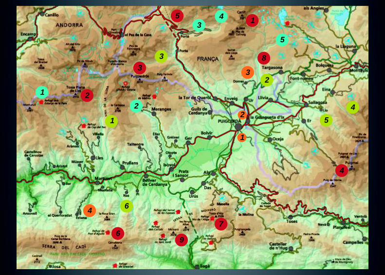
1. Carlit 2. Tossa Plana de Lles 3. Puigpedrós 4. Puigmal 5. Coma d´Or 6. Comabona 7. Tosa d´Alp 8. Moros Peak 9. Moixeró Peak
Ascents 1. Sant Marc Path 2. Els Enamorats Path(Rigolisa) 3. Excursion to Bell-Lloc 4. Prat de Cadí
1. Pera Lakes 2. Malniu Lakes 3. Fontviva Lake 4. Lanós Lake 5. Route along Bollosa Lakes
1. Llosa Valley 2. Angostrina Valley 3. Campcardós Valley 4. Eina Valley 5. Llo Valley 6. Ridolaina Valley
Walks Lakes Valleys
Itineraries
Alfons Brosel
Manel Figuera
Fauna and flora
Oriol Mercadal
Design
cisglobal.info
Photography
Alfons Brosel
Albert Piñeira
Emili Giménez
Juan Reyes
Communauté de Communes
360 Virtual Tour
cerdanyainteractiva.com
Manel FigueraNordic Walking
E. E de Marxa Nòrdica de La Cerdanya
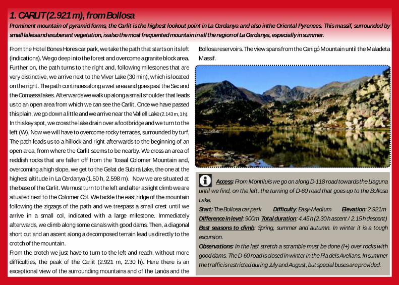
From the Hotel Bones Hores car park, we take the path that starts on its left Bollosa reservoirs. The view spans from the Canigó Mountain until the Maladeta
(indications). We go deep into the forest and overcome a granite block area. Massif.
Further on, the path turns to the right and, following milestones that are
very distinctive, we arrive next to the Viver Lake (30 min), which is located
on the right. The path continues along a wet area and goes past the Sec and
the Comassa lakes. Afterwards we walk up along a small shoulder that leads
us to an open area from which we can see the Carlit. Once we have passed
this plain, we go down a little and we arrive near the Vallell Lake (2.143 m, 1 h).
In this key spot, we cross the lake drain over a footbridge and we turn to the
left (W). Now we will have to overcome rocky terraces, surrounded by turf.
The path leads us to a hillock and right afterwards to the beginning of an
open area, from where the Carlit seems to be nearby. We cross an area of
reddish rocks that are fallen off from the Tossal Colomer Mountain and,
overcoming a high slope, we get to the Gelat de Subirà Lake, the one at the
highest altitude in La Cerdanya (1.50 h, 2.598 m). Now we are situated at
the base of the Carlit. We must turn to the left and after a slight climb we are
situated next to the Colomer Col. We tackle the east ridge of the mountain
following the zigzags of the path and we trespass a small crest until we
arrive in a small col, indicated with a large milestone. Immediately
afterwards, we climb along some canals with good dams. Then, a diagonal
short cut and an ascent along a decomposed terrain lead us directly to the
crotch of the mountain.
From the crotch we just have to turn to the left and reach, without more
difficulties, the peak of the Carlit (2.921 m, 2.30 h). Here there is an
exceptional view of the surrounding mountains and of the Lanós and the
Access: From Montlluís we go on along D-118 road towards the Llaguna
until we find, on the left, the turning of D-60 road that goes up to the Bollosa
Lake.
Start: The Bollosa car park Difficulty: Easy-Medium Elevation: 2.921m
Difference in level: 900m Total duration: 4.45 h (2.30 h ascent / 2.15 h descent)
Best seasons to climb: Spring, summer and autumn. In winter it is a tough
excursion.
Observations: In the last stretch a scramble must be done (I+) over rocks with
good dams. The D-60 road is closed in winter in the Pla dels Avellans. In summer
the traffic is restricted during July and August, but special buses are provided.
1. CARLIT (2.921 m), from BollosaProminent mountain of pyramid forms, the Carlit is the highest lookout point in La Cerdanya and also inthe Oriental Pyrenees. This massif, surrounded by
small lakes and exuberant vegetation, is also the most frequented mountain in all the region of La Cerdanya, especially in summer.

2. TOSSA PLANA DE LLES (2.916m), from PradellVoluminous, the Tossa Plana de Lles or the Portelleta peak is the second highest mountain in La Cerdanya. Its simple ascent from the Padrell, accessible by car
from Cap del Rec, is highly made up for the wonderful view seen from the top.
From the Padrell (2.115 m) we take the path No. 19 (indicator) of Senders de La Cerdanya route, indicated with yellow rectangles. We will immediately go in to a
black pine forest. Next, there is a slope fairly steep that comes out from the forest and gets to the vast plain Pla de les Someres (2.335 m, 35 min), where there are
the remains of a hut. We must go up along a grassy crest with pine trees on the left until the base of the wide south slope of the mountain. The path is a little
diffuse, but the rest of the ascent is clear. The route is indicated with paint marks and several milestones. On the left, a small path, which we need not to follow,
leads us to the puddle Bassota de Setut. The route gains altitude constantly until a first plain, afterwards it increases appreciably and finally it dims at the top, at
the beginning of the rocky granitic culminating high plain.
Without more obstacles we reach the Tossa Plana de Lles peak (2.916 m, 2 h), excellent viewpoint of La Cerdanya, Andorra and the Pyrenees. In the west, we can
see the Maladeta Massif and the Mieidia de Bigòrra peak. In the south, the Cadí mountain range and the Baridà Mountain and in the east, the view goes on until
the Canigó Mountain.
Access: From Martinet we take the LV-4036 road until Lles and then a
tarmac road until the reception of the Nordic ski resort of Cap del Rec.
Afterwards, we must take a dirt track, able for cars, until the Padrell, where
there is a refuge.
Start: The Pradell Difficulty: Easy-Medium Elevation: 2.916m
Difference in level: 801 m Total duration: 3.30 h (2 h ascent + 1.30 h descent)
Best seasons to climb: Spring, summer and autumn.
Observations: In winter the track is closed from Cap del Rec and if we do not
have skis we must follow an indicated path for snowshoeing until the Pradell
(45 min). The ascent is easy, perfect for beginners.
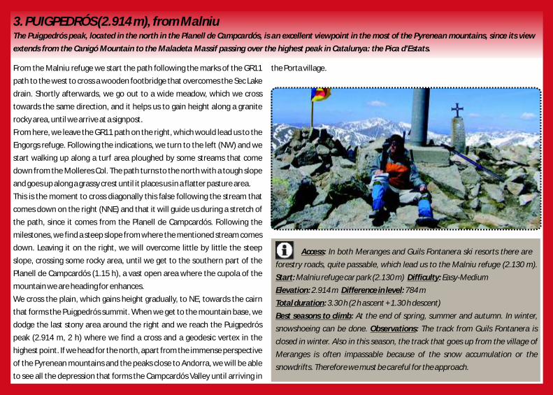
3. PUIGPEDRÓS (2.914 m), from MalniuThe Puigpedrós peak, located in the north in the Planell de Campcardós, is an excellent viewpoint in the most of the Pyrenean mountains, since its view
extends from the Canigó Mountain to the Maladeta Massif passing over the highest peak in Catalunya: the Pica d'Estats.
From the Malniu refuge we start the path following the marks of the GR11 the Porta village.
path to the west to cross a wooden footbridge that overcomes the Sec Lake
drain. Shortly afterwards, we go out to a wide meadow, which we cross
towards the same direction, and it helps us to gain height along a granite
rocky area, until we arrive at a signpost.
From here, we leave the GR11 path on the right, which would lead us to the
Engorgs refuge. Following the indications, we turn to the left (NW) and we
start walking up along a turf area ploughed by some streams that come
down from the Molleres Col. The path turns to the north with a tough slope
and goes up along a grassy crest until it places us in a flatter pasture area.
This is the moment to cross diagonally this false following the stream that
comes down on the right (NNE) and that it will guide us during a stretch of
the path, since it comes from the Planell de Campcardós. Following the
milestones, we find a steep slope from where the mentioned stream comes
down. Leaving it on the right, we will overcome little by little the steep
slope, crossing some rocky area, until we get to the southern part of the
Planell de Campcardós (1.15 h), a vast open area where the cupola of the
mountain we are heading for enhances.
We cross the plain, which gains height gradually, to NE, towards the cairn
that forms the Puigpedrós summit. When we get to the mountain base, we
dodge the last stony area around the right and we reach the Puigpedrós
peak (2.914 m, 2 h) where we find a cross and a geodesic vertex in the
highest point. If we head for the north, apart from the immense perspective
of the Pyrenean mountains and the peaks close to Andorra, we will be able
to see all the depression that forms the Campcardós Valley until arriving in
Access: In both Meranges and Guils Fontanera ski resorts there are
forestry roads, quite passable, which lead us to the Malniu refuge (2.130 m).
Start: Malniu refuge car park (2.130 m) Difficulty: Easy-Medium
Elevation: 2.914 m Difference in level: 784 m
Total duration: 3.30 h (2 h ascent + 1.30 h descent)
Best seasons to climb: At the end of spring, summer and autumn. In winter,
snowshoeing can be done. Observations: The track from Guils Fontanera is
closed in winter. Also in this season, the track that goes up from the village of
Meranges is often impassable because of the snow accumulation or the
snowdrifts. Therefore we must be careful for the approach.

4. PUIGMAL (2.911 m)The Puigmal Mountain is the fourth elevation of La Cerdanya and one of the four mountains of this region that exceed 2.900 m. It is also the highest peak in
the Ripollès region. For this reason, the summit is very frequented by the mountain climbers that reach it for both sides La Cerdanya and Ripollès.
We start in the last capacitated car park of the Puigmal ski resort and we (2.911 m, 2 h), where we find a cross and also a plaque with a passage of the
follow the tarmac road stretch until a water treatment building. From here, Canigó, a notable poem of the Catalan poet Jacint Verdaguer.
we leave the tarmac and we go on along a narrow dirt track, surrounded by
broom thickets, that crosses the irrigation channel of Aiguaneix. We cross it
and we go on along a grassy slope until we find a track.
In this key spot, instead of following the river course, we turn to the right
and shortly after we see a marked big rock that shows us the path towards
the Puigmal Mountain. We begin the sudden and winding ascent (S),
among rhododendron thickets, following the paint yellow marks. At the
end of this slope we find a plain. Here, we must turn to the east and walk up
along another steep slope with decomposed soil until we arrive in a turf
plain.
From this plainer area, we start a diagonal short cut, we pass past a hut in
ruins (1 h), and we head for the south to find the visible hollow Clot de la
Pastera. When we arrive, we find the wide path that comes from the Tossa
del Pas dels Lladres on the right. However, we start walking up towards the
left along a decomposed and vertical path. Higher up, the route goes in to a
rocky chaos, where the snow remains until the beginning of the spring.
Several little paths cross this rocky area, but all of them end up at the
mountain crest (1.45 h). When we get to the crest, we already see the
undulating landscapes of the Ripollès region. Now, we must follow to the
right (E), along the path that goes on along the hillside that leads to the top
and arrives at the base of a rocky hill. We pass this hill and we reach its
highest part, from where we begin to distinguish the Puigmal peak. We
head it for crossing an area of plain rocks and we arrive in the Puigmal peak
A ccess:
Start: Difficulty: Easy-Medium.
Elevation: 2.911 m Difference in level: 940 mTotal duration: 3.30 h (2 h
+ 1.30 h ) Best seasons to climb: Observations:
From Bourg-Madame we take the N116 road towards the village
of Sallagosa until we find, on the right, the turning that leads to the Puigmal ski
resort. Along this tarmac road, we cover the 11 km that guide us to the last car
park. The last car park of the Puigmal ski resort.
ascent
descent The entire year. As we
move along high mountain terrain, we must be well-equipped. In winter,
snowshoeing or mountaineering ski can be done. In winter conditions, ice axe
and crampons are required.
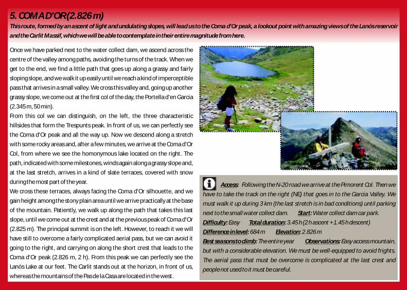
5. COMA D'OR (2.826 m)This route, formed by an ascent of light and undulating slopes, will lead us to the Coma d'Or peak, a lookout point with amazing views of the Lanós reservoir
and the Carlit Massif, which we will be able to contemplate in their entire magnitude from here.
Once we have parked next to the water collect dam, we ascend across the
centre of the valley among paths, avoiding the turns of the track. When we
get to the end, we find a little path that goes up along a grassy and fairly
sloping slope, and we walk it up easily until we reach a kind of imperceptible
pass that arrives in a small valley. We cross this valley and, going up another
grassy slope, we come out at the first col of the day, the Portella d'en Garcia
(2.345 m, 50 min).
From this col we can distinguish, on the left, the three characteristic
hillsides that form the Trespunts peak. In front of us, we can perfectly see
the Coma d'Or peak and all the way up. Now we descend along a stretch
with some rocky areas and, after a few minutes, we arrive at the Coma d'Or
Col, from where we see the homonymous lake located on the right. The
path, indicated with some milestones, winds again along a grassy slope and,
at the last stretch, arrives in a kind of slate terraces, covered with snow
during the most part of the year.
We cross these terraces, always facing the Coma d'Or silhouette, and we
gain height among the stony plain area until we arrive practically at the base
of the mountain. Patiently, we walk up along the path that takes this last
slope, until we come out at the crest and at the previous peak of Coma d'Or
(2.825 m). The principal summit is on the left. However, to reach it we will
have still to overcome a fairly complicated aerial pass, but we can avoid it
going to the right, and carrying on along the short crest that leads to the
Coma d'Or peak (2.826 m, 2 h). From this peak we can perfectly see the
Lanós Lake at our feet. The Carlit stands out at the horizon, in front of us,
whereas the mountains of the Pas de la Casa are located in the west.
Access:
Start:
Difficulty: Easy Total duration: 3.45 h (2 h + 1.45 h )
Difference in level: 684 m Elevation: 2.826 m
Best seasons to climb: Observations:
Following the N-20 road we arrive at the Pimorent Col. Then we
have to take the track on the right (NE) that goes in to the Garcia Valley. We
must walk it up during 3 km (the last stretch is in bad conditions) until parking
next to the small water collect dam. Water collect dam car park.
ascent descent
The entire year Easy access mountain,
but with a considerable elevation. We must be well-equipped to avoid frights.
The aerial pass that must be overcome is complicated at the last crest and
people not used to it must be careful.

6. COMABONA (2.554 m), from prat d'AguilóAt the oriental extreme of the Cadí mountain range the Tancalaporta Mountain rises, also known in the hiking world as Comabona. Its strategic situation
turns the peak into one of the best viewpoints in La Cerdanya. The easiest ascent route to reach the Golosans pass and the peak following a rocky crest line
without difficulties is from Prat d'Aguiló, accessible by a track from Montellà.
From the car park at the end of the track (1.980 m) that comes from finally reach the panoramic peak of the Comabona or Tancalaporta
Montellà, we must go up on foot –there is a chain that prevents the (2.554 m 1.30h), where there are the remains of a geodesic small tower.
entrance of the no authorized cars– until Prat d'Aguiló, where there is its
kept refuge (2.040 m, 10 min). The white and green strips of the PR C-124
path that follows the route Ruta dels Segadors –which the harvesters from
the village of Gòsol did in the past when they went to reap to La Cerdanya–,
and the orange circles of Cavalls del Vent –the circuit that links all the Parc
Natural del Cadí-Moixeró refuges– indicate a path that passes past a
fountain and goes up to a grassy flat area with a small black pine forest.
Afterwards, it goes deep into the top of the Bastanist Valley and, doing
some loops with a steep slope, crosses a limestone area and arrives in a
rocky cornice where the slope decreases. That is how we reach the
Gosolans pass (2.430 m, 1 h), that also crossed the painter Pablo Ruiz
Picasso in the summer of 1906 when he finished his stay in Gòsol.
We leave the PR C-124 path and we can take the GR 150-1 on the left, a path
that crosses the Cadí mountain range and the Moixeró Mountain along the
crest line. Anyhow, it is better not to follow it because it does not go up to
the top of the Comabona Mountain, since it avoids it across the southern
hillside. The more useful and attractive thing to do, it consists in covering
the Cadí mountain range crest line, located on the left, until the next Aguiló
peak (2.494 m, 1.10 h). The crest line turns to the right. We cross some
meadows and overcome a calcareous step to arrive to the hill top of Font
Tordera (2.526 m, 1.15 h). Then we go down to the Comabona Col and we
continue along the crest line. After, we go round a small terrain fault and we
Access:
Start: Prat d'Aguiló Difficulty: Easy
Elevation: 2.554 m Difference in level: 604m Total duration: 2.30 h (1.30 h
+ 1h ) Best seasons to climb:
Observations:
From Martinet we take the LV-4055 road until Montellà and then
a narrow tarmac road. Shortly after, we find the long track on the right (13 km),
not always in good conditions.
ascent descent Late spring, summer and autumn.
In winter, the track is usually impracticable because of the snow
and it is not until the late spring that can be passed. The ascent to the Golosans
pass is, anyway, complicated due to the inclination of the snow-covered slope
(35°). There are generally snowdrifts before the Gosolans pass (ice axe and
crampons are useful).

7. LA TOSA D'ALP (2.537 m), from coma OriolaLa Tosa d'Alp or the Alp hill is maybe the most humanized mountain in La Cerdanya due to the fact that the Alp-2500 area is located there. This area includes
La Molina and Masella ski resorts. It is very frequented because a lot of ski lifts, among them a box lift, arrive at the topmost high plain, where there is the Niu
de l'Àliga refuge. However, in the off-tracks this humanization disappears and we find the nature reserve Parc Natural del Cadí-Moixeró. The view from the
peak, though, spans all La Cerdanya and a large part of Catalunya.
From the car park of Coma Oriola Mountain (1.940 m) we must go towards
the homonymous hollow, but we leave the ski trail that covers it on the left.
At the first grassy flat area (2.000 m, 5 min) we take a path on the right that is
blurred at the beginning because of the livestock pass. This path goes round
a calcareous spur and goes deep into a black pine forest. Indicated with
milestones, it immediately gains height with a steep and constant slope
through the forest. When we come out, we find the Prat de la Tosa
(2.200 m, 45 min), a flat area surrounded by rocks. We turn to the left and
we go on along the bottom of a dry torrent. The Tosa peak, with its TV aerial,
is visible on the left. We must cross the Urus open countries and then, doing
loops in the rocky area, we reach the crest line Serrat de les Pedrusques,
from where there is a view over the Moixeró Mountain, the Cadí mountain
range and the Pedraforca Mountain. Following this crest line to the left we
find the Tosa de Das peak (2.448 m, 1.15 h), with a good perspective of the
Fontllebrera hollow, on the right. Along the same crest line, without
obstacles, we go down the small col where there are the remains of the
booth of the miners Minaires and we cross the old track that leaded to the
Mena, a manganese mine. We undertake the final ascent, with a notable
but short slope, until the TV aerial and shortly after until the geodesic small
tower of the Tosa peak (2.537 m, 1.30 h). From up there, in a clear day, we
can even see the Collserola aerial of Barcelona and, on the west, the Pre-
Pyrenean mountain ranges of Aragó, such as the Turbó, the Cotiella or the
Serra de Guara.
A ccess:
Start: Difficulty: Easy Elevation: 2.537 m
Difference in level: 615 m
Total duration: 2 h (1 h + 1 h )
Best seasons to climb:
Observations:
From Alp we take the road that goes to the reception of the
Masella ski resort. Afterwards, we go on along another road on the right until it
ends at the car park of the Coma Oriola.
Coma Oriola car park
ascent descent
Spring, summer and autumn.
In winter it is a tough ascent due to the snow-covered slope, with
a last stretch where ice axe and crampons will be necessary if there is hard snow.

8. MOROS PEAK (2.137 m) This modest mountain in the south is an excellent viewpoint of La Cerdanya. Located in the southern extreme of the Calma, it is accessible from the reception
of the Font-Romeu ski resort. However, from the solar power station Thémis the route is more direct and attractive. The peak is also used to go paragliding.
From the previous open land of the solar power station Thémis (1.622 m), After a couple of loops, we reach the top of the Moros peak (2.137 m, 1.15 h),
we take a track and then an indicated path that goes round right the mirror from where there is a view over all La Cerdanya.
premises towards the Vilalta hollows. This solar power station, which has a
big unmistakable chimney that we can see from the distance, is constituted
by a set of conic mirrors that concentrate the sun light in a solar furnace that
reaches the 3.000 °C. Once we arrive at the hollows, without crossing the
torrent, we follow a path on the right that gains height among broom
thickets. We leave on the left the fountain La Font Grossa (1.860 m, 30 min),
whose water comes out from schistose slabs. On the other side of the
torrent, we can see the remains of a hut.
The path appreciably turns to the right and we find meadows, where the
livestock can graze in depths of winter if there is no snow. Along a moderate
and constant slope we arrive at the Calma, a wide high plain with more
pastures. Among some black pines and jumping some wires for the
livestock, the path is linked to the track that comes from the Clots marsh, at
the reception of the Font-Romeu ski resort level. If there is snow in this
track, Nordic skiing can be practised. Then, we go on to the right until we
find a diversion on the right towards the same direction.
Access:
Start: Difficulty: Easy
Elevation: 2.137 m Difference in level: 515 m
Total duration: 2 h (1.15 h + 45 min )
Best seasons to climb:
Observations:
From the village of Ur, we take the D-618 road that goes along
Vilanova de les Escaldes and Angostrina and crosses the Caos de Targasona, a
place with curious granite rocks that are used by the climb schools. Shortly
before of Targasona, we take the road on the left that goes to the solar power
station Thémis. Solar power station Thémis car park
ascent descent
The entire year, also in winter with not much snow.
The ascent with snow is still easy and it is useful to use
snowshoeing and walking sticks to walk to the peak.

9. MOIXERÓ PEAK (2.091 m)Despite its modest altitude, the Moixeró peak enjoys the fabulous perspective of the La Cerdanya Valley, the Cadí mountain range and the Pedraforca
Mountain. From its top, we also perceive most part of the Catalan central depression where the Llobregat River waters winds.
We cross the metal barrier that blocks the pass of vehicles and, instead of reach the Moixeró peak (2.091 m, 1.15 h). The Montseny and Montserrat massifs
going on towards the south, we immediately take the track that turns to the stand out in the south, often among a sea of clouds.
left. The route follows this track until the Trapa Col (1.824 m). From here,
instead of going down, we follow its route towards the south.
We walk up gradually along this route until we arrive in a kind of green plain,
from where the path goes down a little bit until, in its lowest part, we pass
along the Bagues de Riu, a shadowy and wet area with drinking troughs for
the livestock. Afterwards, we begin to walk up again until the track
practically disappears in a meadow, from where we already see, facing us,
the La Font Freda de Riu Col. We can get to this col doing a diagonal short cut
or following the detours of the track, that go up along the right part of the
meadow.
Font Freda de Riu Col (1.979 m). Suddenly the view gets wider and we see,
at the end of the pasture meadows, the Moixeró peak and, on the left, the
Penyes Altes Mountains, that clearly show us their upper high. Now, we
must cross the meadows along a small path that comes out on the right of
the pastures and leads us to the Moixeró Col (1.972 m, 1 h), along an area
practically plain.
From this col, we perfectly see the silhouette of the Cadí mountain range,
the north side of the Pedraforca Mountain and the path that goes down
towards the Sant Jordi refuge, located at the bottom of the valley. From the
col we are situated in, we turn to the left and go up along a path that leads
us to the mountain crest, where we find some granite dots that mark the
dividing line between La Cerdanya and Berguedà. Now, we just have to
make a last effort to be able to overcome some calcareous rock rungs and
Access:
Start: Difficulty: Easy
Elevation: 2.091 m Difference in level: 340 m Best seasons to climb:
Total duration: 2.15 h (1.15 h + 1 h ) Observations:
Situated in Riu de La Cerdanya, we cross the village and we take
the track, tarmac at the beginning, that goes to the Serrat de les Esposes refuge
and then to the Pendís Col. We follow it until near the turning that would lead us
to the Ingla refuge, where a fence blocks the passage. There is place to park.
Car park located in front of the metal fence
The
entire year. ascent descent
Route with small drop and very recommendable to go for a walk with the family.
However, it is a grateful excursion, since from the Moixeró peak we will enjoy of
an unforeseen and magnificent view. The nature reserve rules must be
respected.
1. SANT MARC PATH This walk will take us along a plain and pleasant route from Puigcerdà to the Sant Marc chapel, located in the municipal district of this village. Afterwards, we
will go until the bank of the Segre River and go back to Puigcerdà along the path that comes from Les Pereres. This route is part of one of the healthy routes by
DipSalut ( Diputació de Girona).
We can leave the car at the car parks located on the south side of the N-152 find a wide bridge, able for cars, that cross the river again and, going to the north,
road, around the square of Sant Martí del Canigó and near the Sant Martí guides us until the golf course again and the Sant Marc chapel, from where we will
industrial area. At the beginning of the Age road, a sign located on the right go back, along the already known path, to the starting point.
path indicates: “camí de Sant Marc”.
It is here where really starts this route. The path, completely plain and
tarmac, goes towards the south. We start walking quietly following the
straight road that traces this wide path. We are surrounded by a line of
trees, in both sides, that will go with us during all the way and where we can
distinguish ash trees, alder trees, poplars and plane trees, among others.
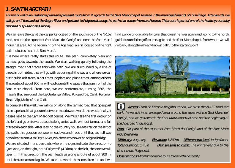
This route, of about 900 m, will lead us until the square that is in front of the
Sant Marc chapel. From here, we can contemplate, turning 360°, the
massifs that surround the La Cerdanya Valley: Puigpedrós, Carlit, Puigmal,
Tosa d'Alp, Moixeró and Cadí.
To complete this walk, we will go on along the tarmac road that goes past
the chapel and that goes on between meadows towards the west; finally, it
passes next to the Sant Marc golf course. We must take the first detour on
the left and go on towards south along a nice walk, without tarmac and full
of trees in each side. After leaving the country house Mas Prat on the left of
the path, this goes on between meadows and trees until that a small way
down leads us next to Segre River, which we cross over an original bridge.
We are situated in a crossroads where the signs indicate the direction to
Queixans, on the right, or to Puigcerdà (4.3 km) on the left, the one we will
take it. In this direction, the path leads us along a route of about 300 m,
until the tarmac road again. We take it towards the same direction until we
Access:
Start:
Difficulty: Very easy.
Total duration: 1.45 h Best seasons to climb:
Observations:
From de Baronia neighbourhood, we cross the N-152 road, we
park the vehicle in an arranged area around the square of the Sant Martí del
Canigó, and we go towards the Sant Marc industrial area and the beginning of
the Age road (indicators).
Car park of the square of Sant Martí del Canigó and of the Sant Marc
industrial area.
The entire year due to the
closeness to Puigcerdà.
Recommendable route to do with the family.
Elevation: 1.200 m Difference in level: Insignificant

2. ELS ENAMORATS PATH PUIGCERDÀ–RIGOLISA It is a very frequented route and its starting is at the environs of the Puigcerdà Lake. The route, surrounded by trees and with good views of La Cerdanya,
follows the network of Senders de La Cerdanya and also a stretch of the ditch that transports water to the lake. This one was the former “Sant Jaume” Path.
It is also part of the healthy routes net created by Diputació de Girona.
Located in the Dionis I Puig square, in the north-eastern part of the we get again to the Ruiz-Zafón literary route and to the starting point.
Puigcerdà Lake, we follow the indications of Senders de La Cerdanya that
mark the direction of the camí d'Ur (route 221). And so then, we take the
direction of this path (north), and we leave on the right the edification of
the Villa de San Antonio, which is located inside the Ruiz Zafón literary route
of Puigcerdà. Soon, we leave the last houses of the village and we head for
the building of the Hospital Transfronterer de La Cerdanya.
After the hospital, the views of the mountains located in the northern La
Cerdanya, Puigpedrós, Roig Col, the Moros peak, etc., are amazing. The
tarmac road goes on until arriving at a crossroads where we find the ditch
and more signs. In this place, we must turn to the right and take the route
number 222, known as “El camí dels Enamorats” (1.6 km). This route
follows a stretch of the ditch and it is really nice, especially in autumn, since
it is completely surrounded by trees that give an appearance quite bucolic.
Halfway of Els Enamorats path, we can follow this path or, if we prefer, we
can go off course to the left to take another unpaved track, which leads us to
the square where there is the Sant Jaume church of Rigolisa, with a Neo-
Gothic chapel that is made up of three parts: a crypt under the presbytery,
the chapel itself and a square belfry of 17 m of height.
We leave behind this place and we take, to the west, a wide promenade
surrounded by poplars, with a route that leads us again to the end of Els
Enamorats path, in the southern entrance. From here, we follow the
Rigolisa Avenue, again with the ditch on our right and, sheltered by the
wide structure of the wall that kept the old prison of Puigcerdà,
A ccess:
Start: Difficulty: Very easy
Elevation: 1.230 m Total duration: De 45 min to 1 h.
Best seasons to climb: Observations:
From Barcelona square of Puigcerdà we go, along the Pons i
Gasch Street, to the Puigcerdà Lake. When we get there, we must continue on
the right along the Pere Borrell Avenue, which goes around the lake in the south,
and then we will arrive at the Dionis Puig square.
Dionis Puig square, in the east of the lake
The entire year The length of this walk
is 3.5 km if we take the straight route along the avenue Els Enamorats Avenue,
and 4.1 km if we go along Rigolisa. It is recommendable doing it with the family,
on foot or by bicycle.

3. EXCURSION TO BELL-LLOC, from DorresPleasant walk that can be done, slowly, in half a morning. The easiest route goes along a cobbled road until the Jovell Col, then it reaches the Argila peak and
arrives at the Mare de Déu de Bell-lloc monastery, from where we can enjoy a dilated view of La Cerdanya.
We can start the excursion at the principal square of Dorres or 10 min GR P du Tour du Carlit goes. The GR P du Tour du Cerdagne goes along a track that
further up, at the Mageta chapel. However, it is better to start at the square goes directly to the Bell-lloc hill, but it is better to go there along another path th (1.431 m), since the Sant Joan Evangelista Romanesque church of the 12 indicated with yellow strips that is higher up on the left (indicator), and which
century of Dorres —inside the Bell-lloc Virgin is venerated— is an attraction after a short stretch of a steep slope goes past the Argila peak (1.704 m). From
of the village. Dorres is also known for the thermal waters. The route is well here, its height decreases along the culminant plains of the Bell-lloc hill until the
indicated. We take a narrow street with red and yellow stripes of two GR de legendary monastery (1.685 m, 1.10 h), a marvellous viewpoint of La Cerdanya
Pays (French paths of small routes): the Tour du Carlit route and the Tour du and of the Alt Conflent region until the Canigó Mountain. The temple is a thCerdagne route. Shortly after, we leave on the left the GR P du Tour de Romanesque building of the 12 century.
Cerdagne, which turns to another street. The other one, the GR P du Tour
du Carlit, goes on along the same street. When it turns to the right, we find
the Mageta chapel with an oratory dedicated to Saint Mark, considerate in
Dorres as the protector of the bad weather and of the lightnings. The signs
go on to the left along an interesting path with cobbled stretches. The path,
among birches and hazels, crosses the Jovell irrigation channel and after
few steps we find, on the left, a turning (indicator) with yellow paint marks.
The slope becomes more pronounced, comes out from the forest and
passes along a pastures before reaching the Jovell Col (1.633 m, 50 min),
the passage for going to Brangolí and Feners small villages, where the
Access:
Start: Dorres Difficulty: Easy Elevation: 1.704 m
Difference in level: 375 m Total duration: 1.45 h (1.10 h + 35 min )
Best seasons to climb: Observations:
From the village of Ur we take the D-618 road, which passes past
Vilanova de les Escaldes. There, in a roundabout, we take on the left the D-10
along the Escaldes until Dorres.
ascent descent
The entire year In depth of winter we
can find glass in the stretches next to the Jovell irrigation channel.

4. PRAT DE CADÍ, from Pallers ColToday, walking until Prat de Cadí has become one of the favourite activities for the tourists that come to La Cerdanya. The truth is that it is a really grateful
excursion that leads people to one of the nicest and most spectacular places of La Cerdanya and of the nature reserve Parc Natural del Cadí-Moixeró.
At Pallers Col (1.490 m) we leave the GR 150 on the right —it goes to the The calcareous northern face of this mountain range is seen in most part of its
Querforadat— and we take towards south the PR C-121, indicated with red extension. Once we arrive at the Roig Col (1.770 m, 45 min) the path becomes
and white stripes. First, it goes along a track and then it takes a path to the plain and crosses a hillside towards the Bastanist Valley, lush of vegetation: black
right that goes up along meadows. Afterwards, it goes deep into a red pine pine forest with firs, white beam trees, birches and rhododendrons. Then, it links
forest with box trees and sallows. Higher up, it goes along the crest line of with a track and reaches the Prat de Cadí (1.820 m, 1 h), magnificent place at the
the spur that forms the Mataplana mountain range and then it arrives at the base of the northern face of the Cadí mountain range. In front of it, between the
Reineres Col, where there is a wooden breach at the entrance. Verda and the Ordiguer rocks, the Canal del Cristall Mountain stands out, where
the PR C-121 goes to, until the Canal de Cristall Col, at the crest line of the Cadí.
However, this ascent is only recommendable for experienced hikers in high
mountain. In the southern extreme of the Prat de Cadí we find the Pi Fountain,
next to the livestock drinking troughs.
A c cess:
Start: Pallers col Difficulty: Easy Elevation: 1.820 m Difference in level: 330 m
Total duration: 1.45 h (1 h + 45 min )
Best seasons to climb:
Observations:
From Martinet we take the LV-4055 road towards Montellà, but
shortly after we leave it on the right and we take another narrow road that
comes out to cross the Bastanist River. We also leave on the left the Bastanist
road and on the right the Béixec road. After some loops to gain height, we arrive
in Estana. From here, we follow a short and narrow track until the Pallers Col,
where there is a waste ground to park the vehicle.
ascent descent
Spring, summer and autumn.
In depth of winter and with snow, the excursion may start in
Estana, 10 min further from the Pallers Col. However, if there is enough snow it is
recommendable to go on snowshoeing until Prat de Cadí.

1. PERA LAKESThe Pera Lakes have been for years a passage used by smugglers from and to Andorra. These two lakes are at the catchment area of the Molí River, in a cirque
glacier located in the head water of the Arànser Valley.
From the Pollineres (2.140 m) we take the path No. 1 (indicator) of Senders
de La Cerdanya (yellow rectangles), that comes from the Fornell area. This
path continues up on the right and avoids a turn of the track. Then, it follows
few meters to the right the track that goes to Cap del Rec area until it
crosses over a bridge the Molí River. Next, the path we must follow turns to
the left, the same does the GR 11-10 —white and red stripes, turnoff of the
GR 11, long path that crosses the Pyrenees from the Biscaia Gulf to the Cap
de Creus— and the Ruta dels Estanys Amagats —blue points, high mountain
route that links several refuges from La Cerdanya and Andorra—. Then, the
path goes deep into the forest and crosses the Molí River across a shallow
stretch. Higher up, it crosses twice the access track to the Estanys de la Pera
refuge and goes along the bottom of the valley, among black pine forests
and glades, until it arrives at the base of granite scarps from where it comes
out a waterfall. From here, the inclination increases until it finds again the
track before the Pera small lake, on the left. The Truita hill or the Perafita
peak, of pyramid form, stands out at the end.
The path avoids the track along the right, it crosses some pastures and it
arrives at the Estanys de la Pera refuge (2.357 m, 45 min), kept in summer, in
holiday periods and some weekends. We can arrive at the Pera big lake
along a track and a plain path on the right in few minutes (2.350 m, 1 h).
It must be said that the name Pera does not have to do with the translation
into Catalan of the word pear, but it refers to a rock as a sign. Similar names
in Catalunya are Peramola, Peralada, Peratallada o Peramea, among others.
A c cess:
Start: The Pollineres Difficulty: Easy Elevation: 2.140 m
Difference in level: 217 m Total duration: 1.45 h (1 h + 45 min )
Best seasons to climb:
Observations:
From Martinet we take the LV-4036 road towards Lles, but
shortly before arriving in Lles we take the road that goes to Arànser. Then, we go
on along a tarmac road that goes up to the Fornell area, at the reception of the
Aransa Nordic ski resort. From here, the track becomes dirt, but generally it is in
good conditions until the Prat Miró and the Pollineres, where there is a refuge
and a family area. We can also get here along Cap del Rec from Lles. The track
goes to the Pera Lakes, but it is closed for motorized vehicles.
ascent descent
Late spring, summer and autumn.
In depth of winter, if the Aransa Nordic ski resort is open it will
not be able to go along the dirt track from the Fornell area. However, there is an
indicated path for snowshoeing that arrives to the Pollineres in 1 hour.
Moreover, this walk and the previous one to the Estanys de la Pera refuge are
highly recommended.
Virtual Tour 360 Scan

2. MALNIU LAKESOwing to its beauty, the Malniu Lakes are the most visited lakes of La Cerdanya in summer, even more than the Pera Lakes. Undoubtedly, their easy access
and the location of the Malniu refuge, have a lot to do with it.
Once we have parked our vehicle, we go back few meters until the cap park
entrance. Just before crossing the stream that comes from the Malniu Lake
drain, we find on the right the signs that indicate the beginning of the route.
The route starts next to the river, goes deep into the forest and, during a
while, continues along the river bank.
During a stretch we follow the red and white marks of the GR 11 route,
painted on the rocks, and also the white and yellow marks that indicate the
small lakes circuit. We go up a first small slope and then another steeper
slope that allows us to gain height. The path is wide and the milestones and
the paint marks guide us to the forest. Then, we arrive in a small plain from
where we can see, in a glade, the Malniu refuge and the car park.
Further on, the GR 11 path turns to the right towards the Feixa refuge, but
we must continue up along the left path, indicated with red and yellow
paint. We pass near a granite rocky area full of rhododendron thickets.
Afterwards, we go out to plainer place where there is a crossroads with a
signpost. We must follow the sign that indicate the right because it is the
correct direction to the lakes. Thus, we cross the plainer area and we get to
the lake drain.
The Malniu Lake (2.250 m, 35 min) is located in a nice place, under the rocks
that are fallen off from the Castell dels Lladres and the Pedró de la Tossa.
The dimension of this lake is amazing. It is recommendable to go for a walk
around the lake to admire its beauty. If we go on along the path, less
indicated now, we can get to the Mal Marsh or to the Guils Lake, surrounded
by rocks.
Access:
Start: Difficulty: Very easy
Difference in level: 120 m Total duration: 1 h ( 35 min + 25 min )
Best seasons to climb:
From Meranges we can get to the Malniu refuge following the
forestry track that goes up there. We can also get there from the Guils
Fontanera Nordic ski resort, following the track that continues along the Pla de
la Feixa and then goes down until the refuge, where there is the car park.
Malniu refuge car park
ascent descent
The entire year. In winter, snowshoeing can be done.
Elevation: 2.250 m
Virtual Tour 360 Scan
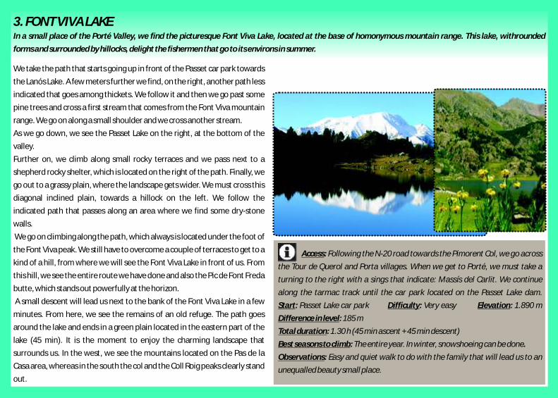
3. FONT VIVA LAKEIn a small place of the Porté Valley, we find the picturesque Font Viva Lake, located at the base of homonymous mountain range. This lake, withrounded
forms and surrounded by hillocks, delight the fishermen that go to its environs in summer.
We take the path that starts going up in front of the Passet car park towards
the Lanós Lake. A few meters further we find, on the right, another path less
indicated that goes among thickets. We follow it and then we go past some
pine trees and cross a first stream that comes from the Font Viva mountain
range. We go on along a small shoulder and we cross another stream.
As we go down, we see the Passet Lake on the right, at the bottom of the
valley.
Further on, we climb along small rocky terraces and we pass next to a
shepherd rocky shelter, which is located on the right of the path. Finally, we
go out to a grassy plain, where the landscape gets wider. We must cross this
diagonal inclined plain, towards a hillock on the left. We follow the
indicated path that passes along an area where we find some dry-stone
walls.
We go on climbing along the path, which always is located under the foot of
the Font Viva peak. We still have to overcome a couple of terraces to get to a
kind of a hill, from where we will see the Font Viva Lake in front of us. From
this hill, we see the entire route we have done and also the Pic de Font Freda
butte, which stands out powerfully at the horizon.
A small descent will lead us next to the bank of the Font Viva Lake in a few
minutes. From here, we see the remains of an old refuge. The path goes
around the lake and ends in a green plain located in the eastern part of the
lake (45 min). It is the moment to enjoy the charming landscape that
surrounds us. In the west, we see the mountains located on the Pas de la
Casa area, whereas in the south the col and the Coll Roig peaks clearly stand
out.
Access:
Start: Difficulty: Very easy Elevation: 1.890 m
Difference in level: 185 m
Total duration: 1.30 h (45 min + 45 min )
Best seasons to climb:
Observations:
Following the N-20 road towards the Pimorent Col, we go across
the Tour de Querol and Porta villages. When we get to Porté, we must take a
turning to the right with a sings that indicate: Massís del Carlit. We continue
along the tarmac track until the car park located on the Passet Lake dam.
Passet Lake car park
ascent descent
The entire year. In winter, snowshoeing can be done.
Easy and quiet walk to do with the family that will lead us to an
unequalled beauty small place.

4. LANÓS LAKEThe biggest mass of water in La Cerdanya, the Lanós Lake is located in an idyllic place and is surrounded by a multitude of spectacular mountains. At the same
time, this small lake is one of the starting points more used to climb the Carlit massif.
At the Passet car park (1.705 m) next to the signs on the left, we see the path clearly shows us its hegemony towards the rest of the mountains.
that goes up among thickets and black pines. We take this path and,
following its loops, we gain height. Few minutes later, we find on the left,
the path that comes from the N-20 road that goes up to the Pimorent Col.
However, we continue on the right and we climb patiently the southern
hillside of the Font Viva mountain range. We are always surrounded by
broom thickets.
When we get next to the cables of the old cable railway (50 min), we see the
Font Viva Lake on the right. From here, the path is plainer and passes along
a spur and then it turns to the left towards the north. Soon, we cross a small
gully and we see, at the bottom of the valley, the spectacular dimension of
the Lanós dam.
We continue along the camí dels Enginyers, a kind of balcony hung on the
left of the valley. The white and red marks of the GR 7 guide us in a wrong
direction towards the dam. We must follow the route of this path,
practically plain, during a while. When it gets near the reservoir, the path
crosses a small wooden bridge that avoids the waters of the Lanós irrigation
channel. Going on towards the north, we leave on the right the path that
would lead us to the Carlit massif and we continue along a grassy flat area,
where the path goes up towards the left part of the reservoir. Thus, we get
next to the lake.
Lanós Lake (2.213 m, 1.45 h). Fabulous place. The enormous mass of water
seems not to have end. On the right, we see the Coma d'Or hill and the
rugged silhouette of the Puigpedrós de Lanós. In the east, it clearly stands
out the Castell Isard peak and the majestic silhouette of the Carlit, which
Access:
Start: Difficulty: Easy Elevation: 2.213 m
Difference in level: 508 m Total duration: 3.15 h (1.45 h + 1.30 h )
Best seasons to climb:
Observations:
Following the N-20 road towards the Pimorent Col, we go across
the Tour de Querol and Porta villages. When we get to Porté, we must take a
turning to the right with a sings that indicate: Massís del Carlit. We continue
along the tarmac track until the car park located on the Passet Lake dam.
Passet Lake car park
ascent descent
The entire year.
The climb to Lanós has not difficult at all during the summer, but
in winter we must be careful if it has just snowed, since in the curve of under the
cable railway cables, avalanches can be formed. It is better not going there in
these conditions.

5. ROUTE ALONG BOLLOSA LAKES The local path of the PR 8 route integrally follows the route of the five lakes that are located under the Bollosa reservoir. It is a nice and easy route that will
show us one of the nicest lakes in La Cerdanya: La Padrella.
From the car park where there is the barrier (1.704 m), we go towards the On the right of the lake, we see the PR 8 path, which we must follow. This path
south along a track that goes to the plain Pla dels Avellans. After crossing a follows the Padrella bank during a stretch to overcome, afterwards, a hillock and
bridge, we go out in the middle of the plain and we turn to the north to go to to go down until the Negre Lake, which is located in a shadowy place
the chair ski lift installations. Behind it, we find the starting point of the (1.947 m, 1.10 h). Now, the path goes on along the left part of this lake until it
route (indicators). arrives at the west part. From here, we start a steep climb, among big rocks. We go
We go deep into the forest and we follow the path, which immediately turns up without a break until the Llarg Lake, which is located down on the right.
to the west. We begin to gain height following the yellow paint marks and After this lake, we must go on along a grassy hollow that will lead us to the Racó
we climb along a slope, which goes through a birch forest, until we arrive at Lake, which is shallow. We leave it behind to cross a forest stretch, turn to the left
and go out in a plain where we find the Bolloseta (2 h), which is a marsh. The path
goes on towards west, under the Bollosa dam, and arrives at the GR 10 path.
When it arrives at the Pla de Bones Hores plain, turns to the south and leads us
again to the Padrella Lake and to the Pla dels Avellans plain (3.10 h).
a forestry track with more indications.
These indications show us the direction towards the Bollosa (GR 10). Then,
we turn to the right and along a plainer terrain we move forward through a
small forest. Next, the path goes up along some rocky stretches until we get
to a hillock where the Padrella Lake is located behind (1.960 m, 55 min).
Access:
Start:
Difficulty: Easy Elevation: 2.005 m Difference in level: 300 m
Total duration: 3.10 h the entire route Best seasons to climb:
Observations:
From Montlluís we go on along the D-118 road towards the
Llaguna until we find, on the left, the turning of the D-60 road that goes up to
the Pla dels Avellans plain and the Bollosa Lake.
Pla dels Avellans car park.
The entire year
The D-60 road is closed in winter at the Pla dels Avellans level
and, for this reason, it is the starting point of this excursion. In summer, the
traffic of the D-60 road is restricted during July and August, but special buses are
provided.

1. LLOSA VALLEYThis route, which crosses the wild the Llosa Valley, was used years ago by smugglers, shepherds, bandits and farmers to go to Andorra. It was also used by the
skinners that carried out the iron that was extracted from the mine located in Pimorent.
From Can Jan de la Llosa (1.610 m), we take a rocky path that is located on GR 107 indications, until the small bridge that avoids the Vallcivera River waters
the right and leads us to the Llosa River, which we cross over a bridge. At the and arrives at the Esparvers booth (2.30 h).
beginning, the path is wide and does some loops among meadows and dry-
stone walls until it arrives at the track that comes from Corrobiu. Shortly
after, we turn to the north and we find a cemented stretch that arrives at
the metallic fence that closes the pass of the vehicles.
We begin to gain height as we see, on the left, the remains of the Llosa
castle. We go deep in to the valley walking along the track (GR 11-10 i 107)
that crosses through a thick blank pine forest, until we pass next to the
Farga booth, located on the right. Following along the track, we arrive at a
wide plain that is crossed by the Calm Colomer torrent, which comes from
the homonymous lake.
The track does a detour, on the right, and we pass along a small torrent.
Then, it turns to the left until we get to a stretch where we definitely turn to
the north along a moderate slope. Thus, we arrive at the Pla de la Molina
plain, where we approach the Llosa River course, until we trespass it over a
bridge and we go out at a wide and precious pasture plain. The river is on
the right, a bit separated. We cross this plain and we go on along the track
that goes up again. When we get to the highest part, we see a big glade in
front of us.
Prat Xiuxirà (2.011 m). Spectacular and charm place (2.15 h). The river flows
on the right, next to the pine trees. The slender siloiuhete of the Muga
Mountain is located on the west. At the middle of this plain we find an
oratory of the Mare de Déu de la Llosa, next to some stone tables. From
here, the track becomes a small path and we can continue, following the
Access:
Start: Difficulty: Easy Elevation:
2.060 m Difference in level: 400 m
Total duration: 4.30 h (2.30 h + 2 h )
Best seasons to climb: Observations:
From Martinet we go towards Lles. At the exit of this village we
find, on the right, a turning that will lead us to Viliella. We cross this village and
follow the track that leads us to Can Jan de la Llosa (3 km), where there is place
to park. Can Jan de la Llosa car park
ascent descent
The entire year In winter, the Llosa track
allows to do this route until the Barraca dels Esparvers on snowshoeing or
mountaineering skis. From here, if we follow towards the Portella Blanca
d'Andorra, the path becomes steeper.

2. ANGOSTRINA VALLEYThe Angostrina Valley connects La Cerdanya with the Carlit massif. For this reason, it is used as a passage way for the livestock that, from Llívia, goes up to
pasture at the Bollosa, using the pasture rights that the stockbreeders of this village have there.
From the car park we cross a barrier with yellow signs. We move forward and that, winding among a black pine forest adorned with broom thickets, it also
towards the north along a shallowly stretch until we get to a rest area gets to the Bollosa Lake (2.017 m, 2.45 h).
located next to the Sant Martí d'Envalls chapel. After this chapel, the path
goes up along a rocky stretch with some water streams. When we finish this
climb, we go out at a sunny plain with some dry-stone walls, where the
valley definitely gets wider.
We follow the “Tour du Carlit” marks and we get to a small water dam. We
cross it and we go up along a small slope from where we can see the Puig del
Cap de l'Home Mountain in front of us. After crossing a plain pasture area,
we go deep into the black pine and hazels forest. The marks lead us until the
Empedrats Bridge, which we use to cross again the Angostrina River (1h).
Now, the path goes up along the east side of the Puig del Cap de l'Home
Mountain. As we walk, we leave behind us this mountain and we cross
along another plain area, where the path is surrounded by rhododendron
and broom thickets.
Patiently, we keep moving forward among thickets towards the ski lifts of
the Font-Romeu ski resort, which we see far away on the right. Further on,
the path we follow leads us to a wide turf area, where the glades
predominate. We cross these glades along the left to avoid some wet areas
and we get to the nice La Padrella Lake, where there is a refuge
(1.960 m, 2.15 h).
Once we have contemplated this lake, we have two options to get to the
Bollosa. The first one and the easiest one is to turn to the left to take a wide
track that directly leads us to the reservoir. The second one and the nicest
one is to continue along the GR-10 path that arrives next to the same refuge
Access:
Start: Can Jan de la Llosa car park.
Difficulty: Easy Elevation: 2.017 m Difference in level: 475 m
Total duration: 5.15 h (2.45 h + 2.30 h )
Best seasons to climb:
Observations:
From Puigcerdà we go towards Angostrina. After this village and
before crossing the homonymous river, we find a turning with indications on the
left that guides us to this valley. We take it and we go up along the road, tarmac
at the beginning, that leads us to the previous car park of the Sant Martí
d'Envalls chapel.
ascent descent
The entire year.
The road that goes up at the car park of the Sant Martí d'Envalls
chapel from Angostrina is closed in summer in the previous capacitated car park
and, for this reason, the route time increases one hour.
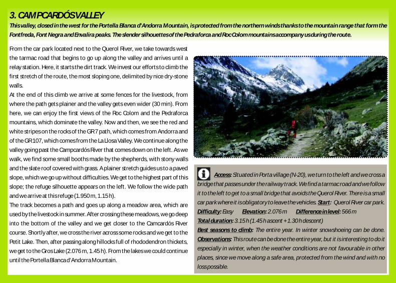
3. CAMPCARDÓS VALLEYThis valley, closed in the west for the Portella Blanca d'Andorra Mountain, is protected from the northern winds thanks to the mountain range that form the
Fontfreda, Font Negra and Envalira peaks. The slender silhouettes of the Pedraforca and Roc Colom mountains accompany us during the route.
From the car park located next to the Querol River, we take towards west
the tarmac road that begins to go up along the valley and arrives until a
relay station. Here, it starts the dirt track. We invest our efforts to climb the
first stretch of the route, the most sloping one, delimited by nice dry-stone
walls.
At the end of this climb we arrive at some fences for the livestock, from
where the path gets plainer and the valley gets even wider (30 min). From
here, we can enjoy the first views of the Roc Colom and the Pedraforca
mountains, which dominate the valley. Now and then, we see the red and
white stripes on the rocks of the GR 7 path, which comes from Andorra and
of the GR 107, which comes from the La Llosa Valley. We continue along the
valley going past the Campcardós River that comes down on the left. As we
walk, we find some small booths made by the shepherds, with stony walls
and the slate roof covered with grass. A plainer stretch guides us to a paved
slope, which we go up without difficulties. We get to the highest part of this
slope; the refuge silhouette appears on the left. We follow the wide path
and we arrive at this refuge (1.950 m, 1.15 h).
The track becomes a path and goes up along a meadow area, which are
used by the livestock in summer. After crossing these meadows, we go deep
into the bottom of the valley and we get closer to the Camcardós River
course. Shortly after, we cross the river across some rocks and we get to the
Petit Lake. Then, after passing along hillocks full of rhododendron thickets,
we get to the Gros Lake (2.076 m, 1.45 h). From the lakes we could continue
until the Portella Blanca d'Andorra Mountain.
Access:
Start:
Easy
Total duration: 3.15 h (1.45 h + 1.30 h )
Best seasons to climb:
Observations:
Situated in Porta village (N-20), we turn to the left and we cross a
bridge that passes under the railway track. We find a tarmac road and we follow
it to the left to get to a small bridge that avoids the Querol River. There is a small
car park where it is obligatory to leave the vehicles. Querol River car park.
Difficulty:
ascent descent
The entire year. In winter snowshoeing can be done.
This route can be done the entire year, but it is interesting to do it
especially in winter, when the weather conditions are not favourable in other
places, since we move along a safe area, protected from the wind and with no
loss possible.
Elevation: 2.076 m Difference in level: 566 m

4. EINA VALLEYthFrom the 17 century, several naturalists have gone along the picturesque Eina Valley due to its botanical diversity: more than one thousand plant species,
some of them are endemic and others have scientific and medical interest. A diverse community of insects also lives there. There are more than seventy
Lepidoptera species. In order to protect this area and its rich patrimony, the Eina Nature Reserve was created. The path we will follow is one of the classical
routes to go to Núria from La La Cerdanya.
On the left of the open land (1.599 m) it begins a path that goes along some the left, 20 minutes away. Further on, the top of the Noufonts high peak (2.861 m)
meadows and goes deep into a black pine forest. Right after, it arrives in a is 45 minutes away. From the col, we can also reach the panoramic top of the
track that comes from the right. We take the track towards left and we go Finestrelles peak (2.828 m) without difficulties in about 30 minutes.
along it until the end. Then, we must continue along a wide path through
the Eina forest. We cross an old irrigation channel and a fence for the
livestock. We pass along the narrowest part of the valley with the Eina River
on the left. We find another fence and we arrive at the Pla de l'Orri plain
(2.015 m, 1.15 h), where the valley gets wider. We go on along the path. The
suntrap hillside is full of broom thickets and the shady full of rhododendron
thickets. In June, when the thickets flower, its contrast becomes bright and
colourful. We overcome some schistose terraces along some loops and we
find, on the left, a nice waterfall. After a while, the path crosses the river
along a shallow stretch and goes up to a shoulder. After a fountain and a
short ascent among stony areas and rhododendron thickets, we leave a hut
on the right, we go up to another shoulder and we get to the Pla de la
Beguda plain (2.335 m, 2.15 h), wide pastures located between the
Finestrelles peak and the Eina tower. From here, the path indicated with
big milestones gains height in loops to arrive in a high passage that
dominates the entire valley: the Eina or Núria Col. Overcoming a constant
steep slope, fairly inclined at the end, we reach this col (2.684 m, 3 h), where
we can see the Núria sanctuary behind it. Along the path that comes down
from the Ripoll region hillside we would get it to in 1.30 h. Another option,
high recommendable, is climb the next top of the Eina peak (2.786 m), on
Access:
Start:
Difficulty: Easy Elevation: 2.684 m Difference in level: 1.085 m
Total duration: 5.30 h (3 h + 2.30 h )
Best seasons to climb:
Observations:
From Sallagosa, we follow the N-116 road towards the Perxa
Mountain until we find on the right a turning that goes to Eina. Then, we follow
on the right the Llo road, which immediately crosses the Eina River. Shortly after,
we find an open land to park on the left.
The open land located at the outskirts of Eina.
ascent descent
In late spring, summer and the first half of autumn.
If there is snow in the lowest part of the valley it is easy to
snowshoeing along the route, but from the Pla de l'Orri plain and especially in
the Eina Col ascent, ice axe and crampons are necessary.

5. LLO VALLEYThis interesting excursion will allow us to go along the beautiful gorges that are formed by the Segre River in its starting. If we want to reach the source of this
river, we will have to continue the walk towards the Finestrelles Col and go off the course before arriving it, at the Font del Segre level.
We start walking passing under the hanging bridge that leads to the
beginning of the Les Escadilles iron road. Leaving this equipped road on the located in front of the refuge, indicate us the beginning of the path that goes to
left, we go on along the tarmac road during a stretch where there is the the Segre Fountains and to the Finestrelles Col.
Segre River on the left. Soon, we can see the impressive southern face of
the Sant Feliu del Castellvell hill and the first narrow turns that the Segre
pools form. Further on, the road crosses a small bridge from where the river
remains on the right. Surrounded by slender and impressive mountain
faces and admiring the beautiful forms of the river, we get to the end of the
road, where we find a last bridge, the turning to the country
h o u s e M a s P a t i r à s a n d s o m e s i g n p o s t s ( 3 5 m i n ) .
Here, it starts the forestry dirt road. We follow it until we arrive at a metal
fence and at a cattle grid for the livestock (1.604 m).
We continue along the track towards the south. The river flows down on
our left now. The track route gains height at the beginning and when it gets
closer the river it gets plainer. We cross a nice small black pine forest and we
go on along the track. On the left, the Serra dels Clots mountain range
stands out and it separates us from the Eina Valley. The track route gains
height gradually and the river is on the east. We keep following it, always
towards the south, until that at the left horizon we can distinguish the
Culassa refuge. Finally, we get at the last bridge of the route. Here, we leave
the turning that goes to the right and ascend until the plain Pla de la Creu, in
a pronounced curve. However, we must cross this bridge, turn to the left
and go towards the surrounding area of the visible Culassa refuge
(1.834 m, 1.45 h). A milestones located at the highest part of the meadow
Access:
Start: Difficulty: Easy
Difference in level: 450 m Total duration: 3.15 h (1.45 h + 1.30 h )
Best seasons to climb:
Observations:
N-116 road towards Sallagosa. In this village, we turn to the right
to take the road that leads us to Llo. Before entering this village, there is a
turning on the right that guides us to the Banys de Llo car park, where we will
park the vehicle.
Banys de Llo car park
ascent descent
The entire year. In winter, snowshoeing until the Culassa
refuge is highly recommended.
Nowadays, the access to the Llo Valley is closed for the vehicles
at the Les Escadilles iron road level.
Elevation: 1.834 m
Virtual Tour 360 Scan

6. RIDOLAINA VALLEYWe can gain access to Prat d'Aguiló along a track from Montellà. However, the recommendable option is from Nas, following the Ruta dels Segadors route
along the Ridolaina Valley. It is also known as the Camí de La Cerdanya route, where the groups of harvesters from Gósol, who were hired in the country
houses of La Cerdanya, passed. In the summer of 1906, the painter Pablo Ruiz Picasso also passed it.
From Nas (1.225 m), we follow a track with white and yellow stripes of the Ridolaina Valley.
PR C-124 path. We must cross the Pla de Nas plain and go up along a short
cut towards the Collet (1.360 m, 20 min). Then, we reach the track. From
the Hereus plains, we can see the ruins of the Sant Romà tower, a medieval
fortification located in the other side of the valley. Higher up, we take
another short cut on the right that crosses an irrigation channel and arrives
at the track in front of the Tosca Fountain. After few steps to the right, along
the track, we get to the Cortal de l'Oriol Fountain (1.560 m, 1.15 h). Above it
there is a meadow with a shepherds' refuge.
Without leaving the track, we go down to Baga, where the track gains
height again. We cross the Abeurador torrent and going past a spur, we
cross the Eres torrent. Higher up, we find a detour to the left
(1.640 m, 1.45 h) that we must take. We leave the principal track and go up
along a secondary track. Shortly afterwards, we must leave it and take a
path, on the left, that goes past the Eres torrent, but it does not crosses it.
The slope increases, but it is pleasant due to the view of the northern
hillside of the Cadí. After a while, we get to a meadow among the forest and
we find a forestry road that passes next to a metal hut. The slope moderates
and along this track we arrive at the track that goes from Montellà to Prat
d'Aguiló at Home Mort Col level (1.850 m, 2.30 h).
We continue along the track towards the left, where a short cut also on the
left leads us close to the car park at the end of the track. The same track
guides us to the Prat d'Aguiló kept refuge (2.040 m, 3 h). From this meadow,
at the foot of the northern face of the Cadí, we can see the entire
Access:
Start: Nas Difficulty: Easy Elevation: 2.040 m Difference in level: 815m
Total duration: 5.30 h (3 h + 2.30 h )
Best seasons to climb:
Observations:
From Bellver de La Cerdanya we take the local road that goes
towards Pi. Then, we continue on the right along another road until Nas. We can
park the vehicle at the village entrance.
ascent descent
Second half of spring, summer and the two first months
of autumn.
In winter snowshoeing can be done.

LANDSCAPE, VEGETATION, FLORA AND MUSHROOMS IN LA CERDANYAfrom here to 1,700 m we can find the red pine forest, mespiluses and hawthorns. which is gradually substituted by the black pine It also has diverse eye-catching, curing, flavoured, forest, which reaches 2.600 m of height. Higher up, toxic and endemic plants to the region or the grassy soil is found. Among the alpine plants, the Pyrenean. it is important to stand out the scree and rocky vegetation the Pyrenean umbellifer, Dracocephalum austriacum, Delphinium montanum, the Pyrenean violet and the Pyrenean saxifrage stand a Pyrenean endemism with more than half the out and there are also small bushes that withstand specimens in the Cerdanya region; the Pyrenean the snow pack, such as the juniper. Due to their size umbellifer, which more than a half of the world's and colour, the spring crocus, the Pyrenean gentian, population is in this region; the alpine daphne (its
Regarding the landscape, La Cerdanya can be the alpine aster, the cushion pink and the black unique location is in the southern Pyrenees). The classified in: the group of the rivers and torrents orchid also stand out. The granitic shale terrains of orchids, the rhododendron thicket and the water surrounded by bank forests, the terraces and the the subalpine zone are also rich in rhododendron chestnut are living fossils, relics of the Tertiary flora, pediments, the medium mountain and the high thickets, together with wild rosebushes and and the white dryas of the Quaternary glaciations. mountain. Due to its orientation, it is also blueberries, while the yellow and fragrant broom Some of the most colourful and curious plants are the structured in suntrap, plain and shady: in the thicket and the bearberry mainly are the carpet of northern rock jasmines and catchflies, the pasque suntrap area, the scrubs and pastures the calcareous soils. In the lower zone, the fir forests, flowers, the butterworts, the cranesbills, the predominate due to an intense deforestation and which are shady and with poor undergrowth, mingles vernalises, the roses, the martagons, the pirola it is remarkable the presence of badlands, clayey with broad leaved forests where the hazel, aspen and neckers, the buttercups, the water forget-me-nots, and knotty terrains that we can find in the villages beech predominate –in the Ingla valley. the lilies, the dogtooth violets, the alpine snowbells, of All or Sallagosa, the granitic landscape found in the snowdrops, the lungworts, the windflowers, the the highest part of Baridà and the Querol Valley, crocuses or the extravagant Botrychium lunaria. The and the crown of slates and shales, as the ones in fungal diversity of the region accumulates at the Bolvir and Vallsabollera. The shady place moment almost 1,500 spring-like or autumn presents brown spots of gorse and broom scrubs, mushroom species, mainly in the subalpine forests red and black pine forests, fir forests (in Riu de and the hayfields. Due to the gastronomic quality and Cerdanya, the Pi Valley, the Mena, Saltèguet and tradition, it is worth mentioning the penny bun, the Sagramorta), and higher up alpine meadows. In a scotch bonnet, also known as fairy ring mushroom, calcareous area of the Batllia, the karstic water the St. George's mushroom, the chanterelle, the effects gave rise to caves, rock shelters, shelters ivory waxy cap, the lactarius, the grey knight and the and ghylls. The vegetation, of alpine continental yellow foot. As a curiosity, there is an eatable nature with Mediterranean features, is arranged The highest part of the montane zone is dominated mushroom quite common in the region but rare or by zones: the alpine, the subalpine, the montane by the red pine, which is the base of the logging and non-existent in the rest of Catalonia: the morel and the plain, from highest to lowest altitude. Up forestry exploitation, and the lowest part abounds (Verpa Bohemica). until 1,300 m the oak wood land is predominant; with pubescent oak forests of box trees, snowy

CERDANYA FAUNA
In the high mountain, in the moors or alpine meadows and in the rocky
areas, we can find the chamois, the marmot, the mole, the hare, the lizard
and the common frog; in the Carlit Massif, the inserted mouflon of Corsica.
Among the birds, the bearded vulture, the golden eagle and the griffon
vulture, the peregrine falcon, the rock ptarmigan, the Eurasian dotterel, the
white-winged snow finch, the grey partridge and the wall creeper. In the
subalpine zone, the black pine forest is richer in fauna because it is a good
shelter for small mammals- as the pine marten, the shrew, the field vole or
the red squirrel, and the birds -the wood grouse, the boreal owl, the black
woodpecker and the common crossbill. Moreover, the suntrap moors
conditions are dry and they allow the presence of Mediterranean species -
as the orphean warblers and some winter sparrows- in considerable there are many wild boars, and in bank forests we can find the thresher shark and
heights. In the medium mountain the mammals are similar, but birdsa are the Eurasian badger, which often look for more humanized habitats. Among the
not: it is worth mentioning the sparrow hawk, the northern goshawk and mammals, the otter and the shore rockling and regarding the birds, lesser spotted
the tawny owl. There are also great spotted woodpeckers, the bullfinch, the woodpecker, the white throated dipper and the little blue heron. The ophidians
different tits, the common firecrest, the short-toed treecreeper and the are represented by the common viper- the only venomous snake in La Cerdanya-
Eurasian jay, among others. The small mammals, as the moles, are used to the viperine snake, the grass snake, and the green whip snake –often up the trees.
living in meadows and in plains, in hayfields and dry fields, frequented by As for the slow worm is not an ophidian, but a lacking legs saurian. Some
granivores birds such as the common wood pigeon, the common quail and troglobite insects, often blind and translucent, live in the caves –such as in Anes,
the red-legged partridge. In the Pi, Ingla and Ridolaina Valleys we can also Olopte and the Fou de Bor – and bats can also be found there. The alpine chough
find some Eurasian eagle-owls. Nowadays, the rabbit and the hedgehogs' and the chough nest live in the entrance well of some cavity, like the Avenç de les
population, abundant not long time ago, are highly decreasing. In the Gralles. The Parc Fluvial de Gallissà has the aim of conserving and protecting the
glades, the sand lizard has one of the few populations in Catalonia. In any aquatic species that live in La Cerdanya. And with a more touristic view, there is
place with enough plant coverage -pine forests and forests of downy oaks- the fauna park of les Angles situated in the Capcir area.
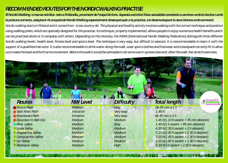
RECOMMENDED ROUTES FOR THE NORDIC WALKING PRACTISE
Nordic walking starts in Finland and it comes from cross-country ski. This physical and healthy activity involves walking with the correct technique and position
using walking poles, which are specially designed for this practise. Its technique, properly implemented, allows people to enjoy numerous health benefits and it
can be practised alone or in company with others. Depending on the intensity, the INWA (International Nordic Walking Federation) distinguish three different
Nordic walking levels: health level, fitness level and sports level. The technique is very easy, but difficult to execute. It is recommendable to learn it with the
support of a qualified instructor. It is also recommendable to drink water along the walk, wear sports clothes and footwear and a backpack correctly fit to allow
us to make the back and forth arms movement. Before the walk it would be advisable to do some warm-up exercises and, after the walk, few stretch exercises.
El Nordic Walking -o marxa nòrdica- neix a Finlàndia, provinent de l'esquí de fons. Aquesta activitat física saludable consisteix a caminar amb la tècnica i amb
la postura correcta, adaptant-hi uns pals de Nordic Walking especialment dissenyats per a la pràctica, tot desenvolupant la seva tècnica amb correcció.
NW Level Difficulty Total lengthRoutesMoros Peak Medium EasySant Marc Path Initiation Very easy Enamorats Path Initiation Very easy Excursion to Bell-lloc Medium MediumPera Lakes Medium EasyLlosa Valley Medium MediumAngostrina Valley Medium MediumCampcardós Valley Medium MediumLlo Valley Medium MediumRidolaina Valley Medium High
de 45 min a 1 h1.45 hde 45 min a 1 h1.45 h(1.10 h ascent + 35 min )1.45 h(1 h ascent + 45 min )4.30 h(2.30 h ascent + 2 h ) 5.15 h(2.45 h ascent + 2.30 h ) 3.15 h(1.45 h ascent + 1.30 h ) 3.15 h(1.45 h ascent + 1.30 h ) 5.30 h(3 h ascent + 2.30 h )
descentdescent
descentdescentdescentdescent
descent
8
1
2
3
1
1
2
3
5
6

MORE INFORMATION
It is important to keep in mind that hiking in the mountain can become a risky activity, since it takes place in a changeable environment and,
sometimes, dangerous. The edition of this guide just wants to show the corresponding routes, but the practise of this sport is everyone's
responsibility.
It is recommendable to take the following precautions:
-Choose routes that suit our physical conditions.
-Find out the weather forecast.
-It is better not doing it alone.
-Record the route we want to cover.
-Be well-equipped with good footwear and enough warm clothes.
-Have plenty of water and energetic food.
-Have the mobile phone charged.
-In the backpack it is necessary to have: a cap, glasses, gloves, a compass, a map, sun cream and an impermeable or Gore-tex.
-The environment must be respected: take away your rubbish, don´t light a fire, follow the signed paths, leave the livestock fences as they
were, etc.
www.cerdanya.org www.puigcerda.cat www.pyrenees-cerdagne.com
WARNINGS

AJUNTAMENTDE PUIGCERDÀ
DipsalutOrganisme de Salut Públicade la Diputació de Girona