k’yuwaatl’aagee / k’yuwaatl’aagaay the haida gwaii ... gwaii trails strategy (final w... ·...
TRANSCRIPT

k’yuwaatl’aagee / k’yuwaatl’aagaay
The Haida Gwaii Trails Strategy
kil.uhlaa1
Plan of Action
Toward Implementing a Trail Strategy for Haida Gwaii
The Final Deliverable of Stage 1 of the Haida Gwaii Trails Strategy Project Misty Isles Economic Development Society May 2011
1 kil.uhlaa [kilgu.hlaa]: In Northern Haida Language: talk it over to create a plan. Translation provided by Claude Jones, Old Massett, fluent speaker of the Haida language.
k’yuwaatl’aagee / k’yuwaatl’aagaay / The Haida Gwaii Trails Strategy, Stage 1 Report
1
Table of Contents
Acknowledgments and Parameters ............................................................................. 3
Indicators for a Trails Strategy and Recommendations ........................................... 4
Trails are Culturally Significant to All Islanders .............................................................................. 4
Haida Gwaii's Trails are Maintained to a Standard Suitable for Public Use ................................. 5
An Islands-wide Trail System with Common Standards and Signage Promotes Recreational and Tourism Opportunities that Boost the Local Economy ............................................................. 5
Standards for Maintenance and Signage of Trails ............................................................................ 6
Trails provide Meaningful Economic Development Opportunities for Local Youth .................... 7
An Islands-wide Management Structure provides for Broad Accountability and Access ............ 7
Ongoing Funding for a Local Trail System is Enhanced by Working as an Island Community . 8
A Comprehensive Trail Inventory for Haida Gwaii is Maintained over the Long Term .............. 8
Organization of Inventory ................................................................................................................... 9
Inventory Maps ..................................................................................................................................... 9
Trails in Gwaii Haanas National Park Reserve ................................................................................. 9
Ancient Undeveloped Trails ................................................................................................................ 9
Bike Trails and Lanes, and Other Uses ............................................................................................ 10
IMPLEMENTATION ................................................................................................. 11
Structure for Decision Making, Funding and Management ........................................................... 11
Trails Advisory Committee or Equivalent Body ............................................................................. 11
Initial Tasks of the Trail Advisory Committee ................................................................................ 12
Trails Manager or Equivalent Position ............................................................................................ 12
Funding and Rational ......................................................................................................................... 13
I. Priority List of Trails for Monitoring and Maintenance and Marketing ......................... 13
II. Maintenance Costing, Job Creation, Economic Development ........................................... 14
CONCLUSION ............................................................................................................ 15
BIBLIOGRAPHY ....................................................................................................... 16

k’yuwaatl’aagee / k’yuwaatl’aagaay / The Haida Gwaii Trails Strategy, Stage 1 Report
2
Appendices ................................................................................................................... 20
Trail Inventory, Maps ........................................................................................................................ 20
List of Acronyms and Haida Language References ........................................................................ 20
"The Link Between Trail Development and Tourism", Excerpt, Synergy Group, 2001 ............ 20
Trail System Funding and Development - Internet Resources ...................................................... 20
k’yuwaatl’aagee / k’yuwaatl’aagaay / The Haida Gwaii Trails Strategy, Stage 1 Report
3
Acknowledgments and Parameters The Real Estate Foundation of British Columbia and the Skeena-Queen Charlotte Regional District have generously supported this project and we would like to express our gratitude. We would also like to thank: Traci Murphy, Executive Director of the Mount Moresby Adventure Camp Society; Fran Fowler and Maureen Weddell of the Over the Hill Hikers Group of Queen Charlotte; Roy Collison, Hereditary Chief of the kunlaanaas territory at North Beach; and Barney Edgars of Old Massett for attending field trips, providing transportation to sites, and discussing trail systems, outdoor educational goals, and the economic development that is associated with trails and eco-tourism. Another partner in this project was Chris Taylor from Back Road Map Books, who collaborated with us in the production of the inventory maps as part of their map project for Haida Gwaii. Haaw.aa to Claude Jones of Old Massett for his consultation on Haida language.
Thank you to members of the public and stakeholders who participated in this project through answering the interest-specific questions, completing the somewhat lengthy questionnaires, and providing additional information when requested. The input from the consultation process provided the base lines from which this document was developed. The main finding of the public and stakeholder consultation process was that trails are an integral part of life for many, if not most, island residents, and therefore continued public and stakeholder consultation will create a relevant trail system for social and economic prosperity. Thank you to the bicyclists, ATV users, horse riders, educators and tree climber who filled out interest-specific questionnaires.
Provincial ministries, volunteer groups, Societies with a trail focus, Municipalities, and Band Councils are the stakeholders that were consulted during the Stakeholder Consultation process. The Gwaii Forest Charitable Trust was also consulted as a stakeholder because they have contributed over one million dollars in recent years towards Haida Gwaii trail-related maintenance and development projects. These stakeholders have invested significant financial and volunteer efforts into the trails of Haida Gwaii over years and decades. The two provincial ministries that are involved in trail maintenance are the Ministry of Environment through BC Parks and Conservancies and the Ministry of Natural Resource Operations through their Recreational Sites and Trails Branch. Both of these ministries expressed interest in the project and contributed advice, support, and completed a stakeholder questionnaire.
As we move forward towards a strategy for managing the trail system, it is with the caveat that the stakeholders identified hold significant knowledge and expertise, and ongoing strategic planning for the trail system will include all of these interests through a proposed islands-wide trail committee, referred to as the Trail Advisory Committee.
We acknowledge the trail inventories and management plans created for Haida Gwaii prior to this project. These inventories include the substantial work of the Island Hikers Association, Old Massett Economic Development, Skidegate Forestry (Spirit Lake Trail), Moresby Island Management Committee, Recreational Sites and Trails BC, and the Ministry of Environment. The historic works of Dalzell2 and Hendersen3
2 See Bibliography, Entries 14, 15
were invaluable to the development of the inventory.
3 See Bibliography, Entry 27

k’yuwaatl’aagee / k’yuwaatl’aagaay / The Haida Gwaii Trails Strategy, Stage 1 Report
4
Haida input to this project has been substantial. The Old Massett Band Council’s Economic Development office provided a significant study on trails and ecotourism and an inventory of trails4
It is important to note that in April 2011 a new management structure for Crown, Provincial Park and Haida Protected Area/Conservancies on Haida Gwaii was established, as reported by the BC Ministry of Aboriginal Relations and the Council of the Haida Nation
. They also provided some information on trails they are currently considering for development. The Hereditary Chief of kunlaanaas shared his thoughts on ecotourism opportunities associated with trails in his clan’s territory. Residents of Skidegate who developed the Look Out Trail, the new connecter that goes from the Spirit Lake Trail to the Haida Heritage Centre at K’aay’llnaagaay, provided a map of their work as well as important input on possibilities for employing students for the summer in local trail management. The Council of the Haida Nation and the Skidegate Band Council did not provide completed questionnaires, however the Skidegate Band Council made questionnaires available to the public via their office. Meanwhile the Haida Nation was consulted through the Islands Protocol Table and the Heritage and Natural Resources Committee. The guidance of focusing on the idea of the "Settlement Corridor" is respected by this document and trails located outside of this area are included to reflect feedback from the stakeholders and public only. Any recommendations made regarding trails located within the Haida Protected Areas/Conservancies are done with respect for the over-arching Management Plan for each area.
5
This Strategy was developed with a relatively small budget, and we recognize the limitations of the timeframe within which it was completed. A plan for the proposed Trail Advisory Committee can be found in the Implementation section.
. An essential part of implementing a trail strategy for Haida Gwaii will be to inform and engage this decision making body. Most importantly, working together as an Island Community strengthens all such projects by providing support from all current governments. With a relatively small population of approximately 4500 residents and considering the remoteness of the Islands, we should foster ways of working together on recreational and tourism infrastructure so as to best position ourselves in terms of funding opportunities as they arise.
Three other reports have been completed in preparation for this final strategic document including the Information Gap Analysis Report, the Report on the Public and Stakeholder Consultation Process (Stage 1), Parameters and Results, and the Interim Report for Stage 1. In the digital version, these reports are appended and are available on the MIEDS website (www.mieds.ca).
Indicators for a Trails Strategy and Recommendations Trails are Culturally Significant to All Islanders
Trails have important cultural significance to the people of Haida Gwaii. The general public has a significant interest in trails as has been demonstrated by the results of the Public Consultation process for this Strategy6
4 See Bibliography, Entries 18, 61
5 The Haida Gwaii Management Council, See Bibliography, Entry 63
,
k’yuwaatl’aagee / k’yuwaatl’aagaay / The Haida Gwaii Trails Strategy, Stage 1 Report
5
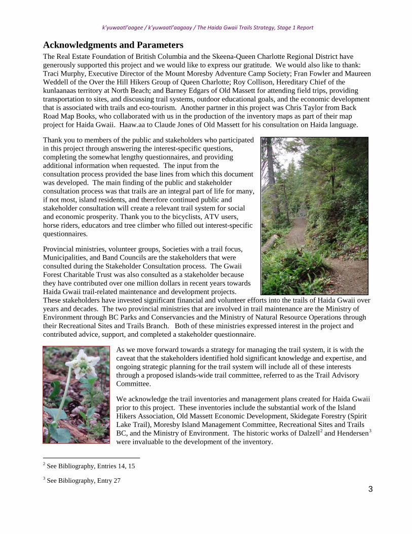
as well as past engagement processes. Many of the trails used today have been used for decades or centuries and some are remnants of a time when people travelled from place to place by foot or boat only. There are trails here that have been created specifically so that people may continue to experience and enjoy rare landscapes and ecosystems. Still other trails remain from early European efforts at land settlement and mining. Hunters and hikers alike use many of these trails today. Hiking provides important fitness and lifestyle enhancement opportunities for a broad range of age groups on Haida Gwaii.
Trails are an important land-based resource to local and non-local hikers, educators, cyclists, the tourism industry, municipalities, and band councils. They have tremendous potential to help grow our local economy in a sustainable manner. However, trails are not mentioned in the Draft Haida Gwaii Strategic Land Use Agreement, HGSLUA7
Haida Gwaii's Trails are Maintained to a Standard Suitable for Public Use
. It is important to have a strategy that adequately and effectively addresses trails.
The Ministries of Natural Resource Operations and Environment have seen their mandates broaden in recent years, yet staffing and funding have not increased to an adequate level to effectively deal with the trails under their jurisdictions. For example, local staff at Recreational Sites and Trails BC (RSTBC) is currently allotted only 8 hours per week for management of the local Recreational Sites and Trails on Crown land8
An Islands-wide Trail System with Common Standards and Signage Promotes Recreational and Tourism Opportunities that Boost the Local Economy
. The Ministry of Environment has had 9 new Haida Protected Areas/Conservancies added in the past year and at this time staffing has not changed to reflect the needs to manage these new areas. Provincial budgets that deal with trails have generally had their budgets substantially reduced over the past decade to the point that Parks and recreational sites across the Province are significantly underfunded.
Some trails are in areas where significant natural blow down occurs annually, creating ongoing maintenance issues, including repairing of structures like bridges and boardwalks, replacing signage, and sometimes re-routing and cutting new trail. Indeed, Haida Gwaii is prone to blow down, and therefore forest trails may require more maintenance than in other regions. During the Public and Stakeholder Consultation Process, various Stakeholders indicated that they were not maintaining all of their trails due to lack of funding.
In order to more effectively ensure the regular and long term maintenance of trails on Haida Gwaii, a renewed approach is needed that results in a commitment for adequate levels of funding and staff resources.
Tourism associated with trails is increasing. Quoting the Trails Strategy for BC9
6 k’yuwaatl’aagee / k’yuwaatl’aagaay – The Haida Gwaii Trails Strategy, Report on the Public and Stakeholder Consultation Process for Stage 1: Parameters and Results, March, 2011. Bibliography Entry 64.
7 Haida Gwaii Strategic Land Use Agreement, draft 2007, and subsequent drafts and appendices as they are created, Ministry of Agriculture and Lands, BC and subsequent managing Ministries, and the Council of the Haida Nation. Bibliography Entry 6. 8 Personal communication, Duke, L, Ministry of Natural Resource Operations, Queen Charlotte
9 Trail Strategy for BC, Draft 2009. Bibliography, Entry 66.
(page 19/20):
"The key trends all suggest increasing demand for community based, highly connected and locally developed trail networks that provide linkages amoungst communities and
k’yuwaatl’aagee / k’yuwaatl’aagaay / The Haida Gwaii Trails Strategy, Stage 1 Report
6
regions, as well as nearby parks and natural areas."
"INCREASING RECOGNITION OF ECONOMIC BENEFITS: Recreational trails are becoming recognized as drivers of economic development and tourism. The links between traditional tourism and outdoor recreation are getting stronger. Communities throughout the province are recognizing the opportunities associated with the recreational trail users as a source of much needed tourism revenues and drivers of economic development for rural communities and urban centers alike. Trails have the advantage of boosting economic activity while contributing positive impacts to community, social development, education of citizens, and the environment. It is also becoming apparent that economic benefits can be compounded if trails are designed and managed as a network of interlinked connections between communities and a range of attractions."
Regional tourism is indicated by the relatively low cost of enjoying trails as opposed to other types of tourism such as marine or floatplane access tourism. Another important reference on the economic value of trail
tourism in the Sunshine Coast Trail Feasibility Study and Business Plan, 2000, Synergy Management Group Ltd.. An excerpt, "The Link Between Trail Development and Tourism" is an appended10
For the purposes of advertising and marketing of trails, common Islands-wide standards and branding of trail difficulty rating, construction and maintenance, and signage is crucial. Tourists are more likely to use a trail or trail system that they know they will not get lost on, where they know the length of the trail, and what the relative difficulty rating is (e.g. is any climbing involved).
.
The various standards employed by the various trail interests should be brought together towards an Islands-wide standard.
Standards for Maintenance and Signage of Trails
Due to the significant consultation processes already in place provincially and with the Haida Nation, it is recommend that signage and trail bed standards reflect those used by BC Parks and Conservancies, and RSTBC. If the trail system is to be marketable and identifiable World-wide, the signage, maintenance level, and difficulty rating must be standardized. In March 2011, RSTBC and BC Parks worked together to create a brochure that advertises some trails on Haida Gwaii, indicating that their standards are relatively similar. RSTBC, the provincial government body that manages trails on the Crown Lands, has detailed standards for trail building and development set out in its guiding documents11
10 Appendix 3, also see Bibliography, Entry 31
11 Recreation Manual, Chapter 10, Ministry of Tourism Culture and the Arts, Bibliography Entry 51
. Following the BC Parks and Conservancies Guidelines for signage seems the most appropriate option for an islands-wide standard, but this is a subject that can only be dealt with effectively through consultation with the Ministry of Environment and Ministry of Natural Resource Operations, RSTBC, and the local trails focused Societies and groups. This could potentially be done most effectively through membership and meetings of the proposed Trails Advisory Committee.

k’yuwaatl’aagee / k’yuwaatl’aagaay / The Haida Gwaii Trails Strategy, Stage 1 Report
7
A sample of trail signage used on Haida Gwaii
Trails provide Meaningful Economic Development Opportunities for Local Youth
An enhanced trail system can offer significant economic development opportunities for local youth by providing regular summer jobs for students in trail maintenance, enhancement, and administration. Working on the land can connect youth to a better understanding of ecological, governmental, and business processes that affect the Islands and the region. Summer jobs, potentially funded in whole or part by Human Resources and Development Canada for trail maintenance, could provide important opportunities for work experience and employment in this area. This allows local youth to bridge their education with local employment and increase the chances of retaining our youth on the Islands to work once they complete their education.
An Islands-wide Management Structure provides for Broad Accountability and Access
Trail system development and associated job creation has been enthusiastically supported by several levels of government, but this support has not always led to project success. In 2010 the Moresby Island Management Committee obtained letters of support from the Parks and Protected Areas Division of the Ministry of Environment, the local Member of Parliament, the local School District, the Village of Queen Charlotte, Gwaii Haanas Tour Operators Association, the local Regional District, Mount Moresby Adventure Camp Society, and the Village of Masset for a Job Opportunities Fund proposal. This project would have created temporary full-time positions for unemployed forestry workers in trail maintenance. This project would have significantly enhanced the North Moresby trail system to make more trails “market-ready”, while helping to mitigate loss of employment in the forest industry. Unfortunately, despite all of this support and two separate applications, the project did not receive a grant from the Job Opportunities Program. Local governments and societies may be putting significant effort into grant proposals, but due to lack of a common strategy for trails on Haida Gwaii and our comparatively small population, individual Haida Gwaii trail initiatives may not receive grants that other larger populations centers are also applying for.
To facilitate working together as an islands-wide trail initiative, this report recommends the establishment of a Haida Gwaii Trail Advisory Committee. Dialogue with stakeholders, including the GTS has indicated support for the proposed creation of an Islands-wide Trail Advisory Committee.

k’yuwaatl’aagee / k’yuwaatl’aagaay / The Haida Gwaii Trails Strategy, Stage 1 Report
8
Ongoing Funding for a Local Trail System is Enhanced by Working as an Island Community
On Haida Gwaii we have a local granting organization called the Gwaii Trust Society, GTS, and a related body, the Gwaii Forest Charitable Trust, GFCT (formerly the South Moresby Forest Replacement Account). GTS and GFCT12 have indicated that guidelines for trail system maintenance, enhancement, and development should be established before their participation in funding of new trail works. There is currently no strategy for delegating money to this important resource, and therefore trail works have been funded ad hoc on a project-by-project basis. Approximately 1 million dollars has been invested by these funds into Haida Gwaii’s trail system in the past 5 years13
In 2008 the Province of British Columbia designated a new Branch of the Ministry of Natural Resource Operations to manage trails on Crown Land called Recreational Sites and Trails BC, (RSTBC). Other parts of British Columbia have completed trail strategies and are using them to secure funding from RSTBC and other partners to enhance their trail systems.
with no measurable indicators of success in terms of economic or social development. In addition, there is no charitable organization that has islands-wide representation that can apply for the substantial amount of charitable grant donations that are available for recreational and social infrastructure like trails. Most funders, the GTS included, often require matching funding from other sources. Some charitable organizations that manage trail systems are currently receiving significant grants from philanthropic groups. These groups support trails because they are seen to provide sustainable, eco-friendly economic and social development.
With a relatively small population islands-wide (approximately 4500), in order to access government services and grants, we need to work together to pursue our goals for recreational and tourism infrastructure. From the Old Massett Village Council, Heritage Site and Trail System, Draft Area and Facilities Plan, Heritage Site and Old Massett Trails system Report14
"…The authors suggest that more preliminary communication between the two sides need to occur, before proposals for development are presented (Norton and Roper-Lindsay, 1992). Working together, conservationists and developers can both meet their goals for a particular area, especially where proper development serves to improve and publicize the conservation values in an area.”
:
A Comprehensive Trail Inventory for Haida Gwaii is Maintained over the Long Term
A complete inventory of the trails of Haida Gwaii is essential for the creation of a strategic plan for trail system maintenance, standardization, and development of interpretive and other opportunities. Previous inventories and trail guides that inform this collection include: Dalzell 1973; Hendersen 1982; Moresby Island Management Committee 2009; Old Massett Economic Development 2003; Islands Hikers Association / Mount Moresby Adventure Camp Society 2007; Over the Hill Hikers Group of Queen Charlotte 2011; and the Tlell Watershed Society 2008. Ancient trails that are no longer commonly used are not included in this inventory, as consultation with the Haida Nation and the newly formed Haida Gwaii Management Council may be
12 These funds were created to forward economic and social development in the islands’ communities when Gwaii Haanas was legally protected from logging. The South Moresby Forest Replacement Account (SMFRA) was re-named in 2009 and is now the Gwaii Forest Charitable Trust (GFCT). It is expected that the GFCT will make a call for grant proposals in early 2012 (stakeholder e-mail communications with Gwaii Trust Society Administrator, 2010 - 11)
13 from e-mail dialogue with Gwaii Trust Society Administrator, 2010-11
14 Old Massett Village Council, Heritage Site and Trail System, Draft Area and Facilities Plan, Sennema, M. and S. Grouette, 1996, p.15. Bibliography Entry 18.

k’yuwaatl’aagee / k’yuwaatl’aagaay / The Haida Gwaii Trails Strategy, Stage 1 Report
9
required. Trails used by or proposed by local people were identified during the Public and Stakeholder Consultation Process, and all of these are included in the inventory15
Organization of Inventory
.
A Microsoft Excel Spreadsheet was determined as the most useful and multi-user friendly format for creating a living document, for the purposes of comprehensive management of a trail system16
. The portion of the trail inventory spreadsheet that is appended to the print version of this report includes trail name and type, general information on the region of Haida Gwaii within which each trail exists, and notes on each trail. It is also available in Adobe pdf format. The digital version of the inventory includes 23 fields that provide comments on several management factors including 'Group or Ministry that provides maintenance', 'trail difficulty rating', 'trail length', 'wheel chair access potential', and so on. Fields can be added or removed as management needs change and develop, according to the objectives determined by the stakeholders. After the hiking trails there are additional entries under 'trails without maps', 'proposed new trails or new trail systems', 'bicycle trails and lanes', and 'all terrain vehicle trails'.
Inventory Maps
Three 1:200,000 scale maps provide an islands-wide view of the areas currently covered by the Haida Gwaii Trail Strategy Inventory. Mapping was completed using existing maps and creating shape files with Back Road Map Books technical assistance. Due to the propriety nature of the maps produced, the digital copy of this report only includes a map that illustrates the numbered points for each trails, excluding trail routes. For a full version of the map, please see the Haida Gwaii map produced by Back Road Map Books or the printed version of the report in each of the Village offices and the MIEDS office.
Trails in Gwaii Haanas National Park Reserve
In direct consultation with management, and in their response to the Stakeholder Consultation Questionnaire, Gwaii Haanas has indicated that at this time, trails are not being promoted or managed in their jurisdiction. Their intent is to provide a wilderness experience on the land and sea. Trails in Gwaii Haanas are not included in this inventory.
Ancient Undeveloped Trails
During this time in the history of Haida Gwaii First Nation Reconciliation is taking place and a joint Provincial and Haida Nation decision making body has recently been established. The Haida Gwaii Management Council is brand new, and it is not clear at this time how decisions regarding trails will take place. Further to the comments made in the Acknowledgements and Parameters Section, ancient trails that are not already in general usage have not been included in this inventory.
It may be noteworthy that First Nations groups and individuals across Canada are involved in identification and evaluation of ancient trails. For one example, a Master thesis is being prepared by a Simon Fraser University student, Kristina Hannis (Canadian Archaeological Association Annual General Meeting and Conference, Calgary, 2010) that will discuss the use of an ancient and post-contact trail system in Alberta siksika / Blackfoot territory. Such a study can provide more certainty to resource development sector and 15 The Inventory of Haida Gwaii Trails is Appendix A.s
16 Personal Communication, MoNRO Queen Charlotte Geomatics Department Representative, Doug Louis
k’yuwaatl’aagee / k’yuwaatl’aagaay / The Haida Gwaii Trails Strategy, Stage 1 Report
10
ancient trail protection, as well as opportunities for ecotourism, cultural education, and cultural re-identification.
Bike Trails and Lanes, and Other Uses
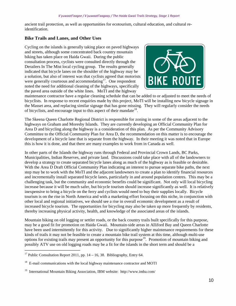
Cycling on the islands is generally taking place on paved highways and streets, although some concentrated back country mountain biking has taken place on Haida Gwaii. During the public consultation process, cyclists were consulted directly through the Derailers In The Mist local cycling group. The results generally indicated that bicycle lanes on the shoulder of the highway may be a solution, but also of interest was that cyclists agreed that motorists were generally courteous and accommodating17. One respondent noted the need for additional cleaning of the highways, specifically the paved area outside of the white lines. MoTI and the highway maintenance contractor have a regular cleaning schedule that can be added to or adjusted to meet the needs of bicyclists. In response to recent enquiries made by this project, MoTI will be installing new bicycle signage in the Masset area, and replacing similar signage that has gone missing. They will regularly consider the needs of bicyclists, and encourage input to this aspect of their mandate18
Mountain biking on old logging or settler roads, or the back country trails built specifically for this purpose, may be a good fit for promotion on Haida Gwaii. Mountain-side areas in Alliford Bay and Queen Charlotte have been used intermittently for this activity. Due to significantly higher maintenance requirements for these kinds of trails it may not be feasible to create a mountain bike trail system at this time, although multi-use options for existing trails may present an opportunity for this purpose
.
The Skeena Queen Charlotte Regional District is responsible for zoning in some of the areas adjacent to the highways on Graham and Moresby Islands. They are currently developing an Official Community Plan for Area D and bicycling along the highway is a consideration of this plan. As per the Community Advisory Committee to the Official Community Plan for Area D, the recommendation on this matter is to encourage the development of a bicycle lane that is separate from the highway. In their meeting it was noted that in Europe this is how it is done, and that there are many examples to work from in Canada as well.
In other parts of the Islands the highway runs through Federal and Provincial Crown Lands, BC Parks, Municipalities, Indian Reserves, and private land. Discussions could take place with all of the landowners to develop a strategy to create separated bicycle lanes along as much of the highway as is feasible or desirable. With the Area D Draft Official Community Plan indicating an interest to pursue separate bike paths, the next step may be to work with the MoTI and the adjacent landowners to create a plan to identify financial resources and incrementally install separated bicycle lanes, particularly in and around population centres. This may be a challenging task, but the community and economic benefits could be significant. Not only will local bicycling increase because it will be much safer, but bicycle tourism should increase significantly as well. It is relatively inexpensive to bring a bicycle on the ferry and cyclists would need to buy their supplies locally. Bicycle tourism is on the rise in North America and with a marketing effort focusing on this niche, in conjunction with other local and regional initiatives, we should see a rise in overall economic development as a result of increased bicycle tourism. The opportunities for bicycling may also be taken up more frequently by residents, thereby increasing physical activity, health, and knowledge of the associated areas of the islands.
19
17 Public Consultation Report 2011, pp. 14 – 16, 38. Bibliography, Entry 64.
18 E-mail communications with the local highway maintenance contractor and MOTI
19 International Mountain Biking Association, IBM website: http://www.imba.com/
. Promotion of mountain biking and possibly ATV use on old logging roads may be a fit for the islands in the short term and should be a

k’yuwaatl’aagee / k’yuwaatl’aagaay / The Haida Gwaii Trails Strategy, Stage 1 Report
11
consideration in the development of an Islands-wide trail system.
Horseback riding on trails is comprised of a small user group that could be explored more in future trail system management if there were interest from the public and stakeholders. Canopy climbing in association with some trails and recreational areas is a sustainable opportunity that could also be marketed. Discussions with a vendor indicated eco-friendly goals of low-to-no impact. This activity is popular in other areas and is suitable for a range of ages. It can provide an opportunity to view the coastal temperate rainforest on Haida Gwaii from a unique perspective, enhancing the experience of some our most spectacular trail adventures.
IMPLEMENTATION Implementation of this Stage 1 phase of the Haida Gwaii Trails Strategy is crucial to achieving the indicators as set out in the first section and honouring the intent and input of the stakeholders and public from this and past processes. The impetus for this rests with Islanders as a whole, however action on behalf of residents needs to be taken by the Communities and the respective local organizations involved with trails, and the relevant Provincial Ministries. Accomplishing what is set out in this document will require significant and focused effort. We have outlined the recommended steps to be taken towards effective implementation below.
The first step of the Haida Gwaii Trails Strategy is for it to be accepted as the common approach to trails on Haida Gwaii by the Communities, Haida, and various stakeholders. This acceptance will ideally lead to concrete movement on the steps to follow, as these steps require that all parties are in relative accord on a common approach if we are to truly be successful. The Protocol Table may be a top level vehicle for the local governments to reach agreement, following which the appropriate body can be engaged or created to carry this initiative forward. This will allow for our trails infrastructure to receive the attention it deserves, while enabling all parties to remain informed and involved.
Structure for Decision Making, Funding and Management
Trails Advisory Committee or Equivalent Body
With respect to the public and stakeholder consultation process for the HGTS Stage 1 and significant investments made into trails over the years, the Trail Advisory Committee may be composed of Directors, appointed or elected from the following trail focused stakeholders. This would result in a rather large group if everyone was to participate, however natural proxies are evident between a number of the stakeholders.
The Gwaii Trust Society and Gwaii Forest Charitable Trust BC Parks and Conservancies Recreational Sites and Trails BC Council of the Haida Nation Haida Gwaii Management Council Old Massett Economic Development Moresby Island Management Committee Misty Isles Economic Development Society Skidegate Band Council Village of Port Clements Village of Queen Charlotte Village of Masset Delkatla Sanctuary Society Mount Moresby Adventure Camp Society Over the Hill Hikers Group, Queen Charlotte Hecate Strait Stream Keepers

k’yuwaatl’aagee / k’yuwaatl’aagaay / The Haida Gwaii Trails Strategy, Stage 1 Report
12
Tlell Watershed Society Derailers in the Mist - Bicycling Group Members of the Community at Large
The committee should follow a clear Terms of Reference that is based on the Heritage Tourism Strategy. As things progress on the Islands, the Trail Advisory Committee could also engage representatives of groups like the National Trails Coalition, Trails BC, and other groups deemed important to trail markets and general focused networking. If significant new funders come on board they might also similarly be engaged by the Committee.
What authority the Committee will report to will need to be decided by the participating stakeholders. It is recommended that any broadly representative organization could facilitate this Committee, with reporting requirements to the Communities and general public to ensure transparency and information sharing. The key will be consistency.
Initial Tasks of the Trail Advisory Committee
1. Establish clear Terms of Reference and receive appointment of representatives from each stakeholder 2. Adopt the Heritage Tourism Strategy as the guiding document for the Trails Strategy and trail
management 3. Set meeting schedule: Suggest 1 meeting per month for first 6 months 4. Identify current funding sources 5. Develop and adopt Haida Gwaii standards for trail rating, maintenance, signage, and marketing 6. work with an existing suitable organization to develop a charitable arm to support potential funding from
philanthropic sources for social infrastructure 7. Create a Priority List of Trails to bring up to marketable standard annually 8. Establish a communication strategy 9. Consider Heritage Trail designation legislation20
10. Consider the Inventory of Trails on Haida Gwaii and choose trails for interpretive/other opportunities.
as a way of recognizing and protecting certain important trails
11. Consider additions and subtractions to the trail inventory fields. 12. With the administrative capacity of the Trails Manager, develop first steps in a marketable islands-wide
trail system.
Trails Manager or Equivalent Position
The position of Trails Manager for Haida Gwaii is a new employment position recommended under this Strategy to be created by an islands-wide trails system program. The job will be best administered under a group with islands-wide representation in its makeup. A variety of existing organizations may be suitable to oversee this position. This position might also be broken down into its different components to allow for it to be incorporated within an existing organizational structure and available staff position, provided the necessary effort and resources will be committed to seeing the work done.
Funding opportunities are often about timing. Having someone in place that regularly
20 Memorandum of Agreement on Trails, Memorandum of Agreement between the Ministry of Forests and the Ministry of Small Business, Tourism and Culture, Province of British Columbia http://www.tti.gov.bc.ca/archaeology/legislation_agreements_policies_guidelines_bulletins/memorandum_of_agreement_on_trails.html Bibliography, Entry 38.

k’yuwaatl’aagee / k’yuwaatl’aagaay / The Haida Gwaii Trails Strategy, Stage 1 Report
13
checks for new funding for trails and recreational infrastructure is very important. Getting in at the beginning of a call for proposals is key to ensuring that the required consultations have time to take place, and information gathering to support the proposal is complete.
With regards to implementing the Trails Strategy, the Manager's first priority is to engage with the Committee and key stakeholders to find out how the Strategy should work operationally and legally, in concert with the Reconciliation of Aboriginal Rights and Title and the new management approach through the Haida Gwaii Management Council. Most of the trails under consideration exist on Crown Lands and BC Parks and Conservancies, and this reconciliation process affects all of these lands.
The Trail Manager will ensure that summer student positions in trail maintenance are secured through Human Resources and Development, Canada (HRDC), and other sources. Student jobs in trail maintenance are indicated in the Public and Stakeholder Consultation report as an important opportunity to bring our young people back to the islands in the summer to engage in healthy outdoor employment that will provide important local work experience in forestry, ecology, management and design among other skills. Other opportunities exist for work experience and maintenance of trails such as the Hecate Strait Employment development Society's work experience program.
Funding and Rational
Trail based organizations on Haida Gwaii have found it nearly impossible to secure the funding they need to maintain their trail systems to a standard suitable for marketing. This is due in part to limited maintenance budgets and funding opportunities and the lack of a comprehensive plan for trails on Haida Gwaii. If our trails cannot be maintained to a safe and useable standard then there is no option for marketing them and opportunities for local benefits are quickly lost given the annual impacts of blow down trees, trail bed erosion, and growth of underbrush. Trail development funding has been difficult to secure. By working together we can be eligible for grants and services related to trails and recreational infrastructure, and use them in a more strategic and effective manner.
For many potential funding sources, charitable status is a requirement. There is no organization that exists on the islands at this time that has both islands-wide representation and charitable status with a recreational infrastructure mandate. Having an existing or new local organization obtain charitable status could help the islands on all levels of recreation and provide a base from which to apply for a much larger and substantial pool of grants. In particular, grants from philanthropic sources such as banks, car manufacturers, fishing lodges and other corporations, societies and individuals that support healthy social infrastructure development can be very substantial. An example of a local Development Corporation that did this in the past is the Greater Massett Development Corporation, who created the Massett Recreation Centre Charitable Corporation in 2001. In this example, the charitable Corporation represents the Villages of Masset and Old Massett and allows these communities access to charitable funding sources. An islands-wide organization obtaining charitable status would be a significant step towards the development of sustainable recreational and social infrastructure.
Funding options for Stage 2, Implementation of the Trails Strategy, have been a significant consideration of Stage 1. A list of potential funding sources has been developed (see Appendix D). This list is not exhaustive and should be amended regularly to keep up with the changes to government programs and services as represented by the grants they offer for various project types. The Gwaii Trust Society and Gwaii Forest Charitable Trust, along with the Skeena Queen Charlotte Regional District are indicated as key organizations to apply to for funding Stage 2 of the Implementation of the Strategy.
I. Priority List of Trails for Monitoring and Maintenance and Marketing
Several aspects of a Trail Strategy for Haida Gwaii require the engagement of the Trails Advisory Committee.

k’yuwaatl’aagee / k’yuwaatl’aagaay / The Haida Gwaii Trails Strategy, Stage 1 Report
14
It is only through the deliberations of this committee that decisions on annual monitoring and maintenance and a priority list of trails for management can be reasonably determined with all of the identified interests in trails present and in agreement. With trails and trail users throughout the islands, it is clear that the Islands-wide approach will mean that some trails in some areas may not get the attention that their trail group feels is required at the beginning, however, starting from the premise that we begin with a priority list that engages the entire islands, there should be opportunity for all areas to benefit for enhanced trails in their area more and more as the trail system develops. The intention of the Committee should be to support independent stakeholder group projects and application by providing guidance on the strategic selection of projects and more effective use of available funding, rather than to restrict or deter the interests of a specific group from their trails of interest should the funding be available.
Marketing of the trail system should be discussed with the Haida Gwaii Trails Advisory Committee in terms of partnering on existing marketing initiatives by the MIEDS, BC Parks and Conservancies, and RSTBC. All of these groups have significant marketing that can be tapped into to enhance the entire trail system. In this way partnerships will be encouraged towards more effective marketing. North West BC Regional trail initiatives should be researched as there are trails systems throughout the North that may want to engage in joint marketing campaigns. For example Kitimat recently designated the Yukon Telegraph trail as a Heritage Trail, and over time will be working on to develop it more as a tourist destination. Perhaps a Northwest regional trail guide could be considered as a useful opportunity to get all the trail groups working together. A Haida Gwaii Trail Guide was indicated as a need during the public consultation process and will need to be addressed by the Haida Gwaii Trails Advisory Committee when the strategy is further developed. The recent Recreation Sites and Trails map completed by Back Road Map Books is a valuable resource for this purpose in the short term.
Down the road, attending conferences that focus on trail development may also go a long way to forwarding our trail system funding model. The benefits of joining the Trails BC Society and Trans Canada Trail, among other networking opportunities, requires further research.
Bicycling can be marketed in the short term. A cycling brochure could be developed to suit the needs of individuals and families. It should include instructions regarding ferry travel, campgrounds, hotels and B&B's for example. It is less expensive to put a bike on the ferry than a car, and cycling tourism is on the increase across North America. This is an area that can be developed fairly quickly to improve our economy.
II. Maintenance Costing, Job Creation, Economic Development
From 2006 - 2009 The Moresby Island Management Committee, MIMC, completed significant work on costing of trail maintenance and enhancement costs for existing trails in their jurisdiction. These reports can be used for reference with regards costing out trail maintenance for Haida Gwaii. A recent estimate for annual maintenance of trails is $ 250 per km of trail21
21 Personal E-mail Communication, Jason Shafto, Tlell Watershed Society, May 2011
. This includes wages that are not subsidized by HRDC and is considered very preliminary. Field reconnaissance of the trails under consideration for annual maintenance is required to provide a more reliable figure that also takes all major structure needs into account.
Identification of economic development opportunities associated with an Islands-wide trail system is another important agenda item for the proposed Trails Advisory Committee, and the MIMC Reports and applications should also be referenced in this regard. Some of the contract positions that would be created are in sign making, salvage of cedar and milling of trail components, engineering, danger tree assessment and mitigation, and technical writing for trail guides and other marketing initiatives.

k’yuwaatl’aagee / k’yuwaatl’aagaay / The Haida Gwaii Trails Strategy, Stage 1 Report
15
CONCLUSION Leadership to bring together the trails system for Haida Gwaii has been recommended by local stakeholders for years now22. This fits with the structures already present in Canada and British Columbia23
Continuity of this work is of highest importance. With a strategy in place, local governments may find it within their mandates to work together and support trail system development. What remains to be determined is what islands-wide organization is best suited to carry out this mandate as soon a possible. Without this scale of leadership and priority being placed on our trails infrastructure, this and past processes will continue to only exist as reports on a shelf and our trails infrastructure will only exist where volunteers effort or haphazard funding results in continued regular maintenance.
. As our local funding institutions re-assess their structure and mandates, the trail strategy can provide some considered research to help in these deliberations.
22 Personal Communications with Gwaii Forest Society former Administrator John Farrell, November, 2010, regarding the impetus for the Islands Hiker's Association Project of 2007. See Bibliography, Entry 1.
23 Collaborative planning for trails: Assessing the development of trail strategies in Canada and abroad. A review prepared by MASS LBP for Trans Canada Trail / Sentier Transcanadien and Parks Canada in advance of the National Trail Leadership Roundtable, MASS LBP, 2010.
k’yuwaatl’aagee / k’yuwaatl’aagaay / The Haida Gwaii Trails Strategy, Stage 1 Report
16
BIBLIOGRAPHY 1. Mount Moresby Adventure Camp Society Trail Inventory Initiative (Island Trail Classification and Marketing Initiative). An Initiative to Create the All-Islands Trail Alliance. Working towards A unified Trail Strategy funded by, The South Moresby Forest Replacement Account (SMFRA), Ebbs, J. 2007. On file with the Gwaii Forest Charitable Trust and the Mount Moresby Adventure Camp Society.
2. North Moresby Island Trails Development Project, 2009 Update, Moresby Island Management Committee, 2009.
3. Archaeological Overview Assessment of Northern Haida Gwaii, Stafford J., T. Christensen, with contributions by K. Church, Draft, 2001. On file with the authors, the Council of the Haida Nation, Taan Forest Products Ltd., and the Archaeology Branch of the Province of British Columbia.
4. Haida Gwaii / Queen Charlotte Islands Heritage Tourism Strategy, Haida Gwaii/Queen Charlotte Islands Heritage Tourism Strategy Working Group, 2003
5. Recreational Trails Strategy for British Columbia, Phase 1, Background Report, Ministry of Tourism, Sport & the Arts (MTSA), Ministry of Environment, administrated through the Recreational Sites and Trails Branch of the MTSA, Province of BC, 2007.
6. Haida Gwaii Strategic Land Use Agreement, draft 2007, and subsequent drafts and appendices as they are created, Ministry of Agriculture and Lands, BC and subsequent managing Ministries, and the Council of the Haida Nation, 2007.
7. Naikoon Management Plan, BC Parks, Skeena District, ISBN 0-7726-3134-4, Approved by Markides, H., D. O’Gorman, C. McGregor, 1999.
8. Haida Gwaii / Queen Charlotte Islands Economic Development Accord, as signed by the Municipalities of Haida Gwaii / Queen Charlotte Islands, 2007.
9. Economic Development Understanding, Council of the Haida Nation and the Island Communities, as signed by Council of the Haida Nation and Municipalities of Haida Gwaii / Queen Charlotte islands, 2007.
10. Feasibility Study: Haida Archaeological Forest Trails, Proposal to the Gwaii Trust Society on behalf of the Secretariat of the Haida Nation, 2007.
11. Modeling Paleoshorelines and Locating Early Holocene Coastal Sites in Haida Gwaii, Fedji, D., and T. Christensen, 1999.
12. Haida Dictionary, Enrico, J. Sealaska Heritage Institute, 2005.
13. Dictionary of Alaskan Haida, Lachler, J., Sealaska Heritage Institute, 2009.
14. The Queen Charlotte Islands, Volume 1, 1774-1966, Dalzell, K.E., Harbour Publishing, 1968.
15. The Queen Charlotte Islands, Volume 2, Places and Names, Dalzell, K. E., Harbour Publishing 1973.
16. Moresby Camp (Gillatt Arm) & Shelley Creek (Rennel Sound) Recreation Sites, Haida Gwaii. Archaeological Impact Assessments, Stafford, J. and T. Christensen, for Coast Interior Archaeology. BC heritage Inspection Permit Number: 2007-132, Province of British Columbia, 2007.
17. Summary of Comments, First Nations and Stakeholders Review of Fisher Bay Park Reserve and Boundary Expansion Proposed by Fisher River Cree Nation and the Canadian Parks and Wilderness Society,

k’yuwaatl’aagee / k’yuwaatl’aagaay / The Haida Gwaii Trails Strategy, Stage 1 Report
17
Manitoba Conservation, Manitoba Provincial Government, 2010.
18. Old Massett Village Council, Heritage Site and Trail System, Draft Area and Facilities Plan, Sennema, M. and S. Grouette, 1996.
19. United Nations General Assembly, Preparations for the International Year of Forests, 2011, Report of the Secretary General, August 2009.
20. Haida Dictionary, Enrico, J., 2005.
21. Management Plan for the Terrestrial Area, Gwaii Haanas National Park Reserve and Haida Heritage Site, Archipelago Management Board, 1999.
22. Backcountry Management Approach in Gwaii Haanas National Park Reserve and Haida Heritage Site, Gadja, Anna, Gwaii Haanas National park reserve and Haida Heritage Site, Queen Charlotte BC, 2003.
23. Outdoor Recreation Conflict on Trails in Squamish, British Columbia: An Examination of Theoretical Models and Management, Hildalgo, A., MSc. Thesis, University of British Columbia, Vancouver, 2010.
24. Naden Harbour Archaeological Inventory Survey: Including Portions of Davidson Creek and East Virago Sound, partial fulfillment of British Columbia Heritage Inspection Permit 1999-225, Stafford, J., and T. Christensen, Millennia Research Ltd., 1999.
25. The Ancient Xaada people had an inland trail system on Graham Island, Haida Gwaii. How can evidence of these trails be found?, Requirement for Directed Studies in First Nations Course 442-3, Simon Fraser University, Church, K., 2005.
26. Pacific Northwest Trail Guide, Strickland, R., 2001.
27. Queen Charlotte Islands Trail Hikes and Beach Walks, Fern Henderson, revised version, 1982.
On file in the Reference Section, Vancouver Island Regional Library, Masset Branch.
28. Boat camping Haida Gwaii: A small-vessel guide to the Queen Charlotte Islands, Frazer, Neil, 2001.
29. The Land Use Study of Delkatla Marsh, Masset, BC, Howard Paish & Associates Ltd., Village of Masset, 1973. On file in the Reference Section of the Vancouver Island Regional Library, Masset Branch.
30. North Moresby Island Trail Inventory and Needs Assessment Report, Recreation Resource Limited, (RRL), Moresby Island Resource Development Working Group, Moresby Island Management Committee, 2007.
31. Feasibility Study and Business Plan, Synergy Management Group Ltd. and C. Roddan, ADR Forestry Systems / Shearwater Ltd. Sunshine Coast Trail system. Prepared for Powell River Parks and Wilderness Society and Community Futures Development Corporation of Powell River Region and Human Resources Development Canada, 2000.
32. Inventory of the Queen Charlotte Islands Ermine, Reid, D., L. Waterhouse, P. Buck, A. Derocher, R Bettner, C. French, Fish and Wildlife Branch, Ministry of the Environment, Lands and Parks, Smithers, BC, 1999.
33. Recreational Sites and Trails Branch, Purpose of Program, Ministry of Tourism, Culture and the Arts, 2009.
34. Sea To Sky Corridor Recreation Trail Strategy, Cascade Environmental Resource Group Ltd., under contract to the Province of British Columbia, Ministry of Tourism, Culture and the Arts, Tourism and Resort

k’yuwaatl’aagee / k’yuwaatl’aagaay / The Haida Gwaii Trails Strategy, Stage 1 Report
18
Development Division, Recreational Sites and Trails Branch, Squamish Recreation District, 2008.
35. Holocene coastal reconstruction, Naikoon peninsula, Queen Charlotte Islands, British Columbia, Wolfe, S.A., I.J. Walker, D.J. Hunter, Geological Survey of Canada, Current Research 2008-12, Natural Resources Canada, Government of Canada, 2008.
36. Conservancy Management Plans, draft, Prince of British Columbia and the Council of the Haida Nation, 2009. Access Point: http://www.env.gov.bc.ca/bcparks/planning/index.html#skeena
37. Haida Gwaii Land Use Plan, draft, Province of British Columbia, Council of the Haida Nation, 2009. Access Point: http://www.ilmb.gov.bc.ca/slrp/lrmp/nanaimo/haidagwaii/index.html
38. Memorandum of Agreement on Trails, Memorandum of Agreement between the Ministry of Forests and the Ministry of Small Business, Tourism and Culture, Province of British Columbia
http://www.tti.gov.bc.ca/archaeology/legislation_agreements_policies_guidelines_bulletins/memorandum_of_agreement_on_trails.html
39. Heritage Conservation Act, Province of British Columbia, current version March 2011. http://www.bclaws.ca/EPLibraries/bclaws_new/document/ID/freeside/00_96187_01
40. Over-the-Hill Hikers, blogspot. Village of Queen Charlotte-based trails group. Updates often at: http://over-the-hillers.blogspot.com/search?updated-min=2011-01-01T00%3A00%3A00-08%3A00&updated-max=2012-01-01T00%3A00%3A00-08%3A00&max-results=17
41. The Parks Canada Review 2009-2010, Parks Canada, www.pc.gc.ca/agen/pcrev/~/media/.../Parks_Canada_Review-2010.ashx
42. Haida Gwaii 2011 Investment – Ready Community Profile, Misty Isles Economic Development Society, Queen Charlotte BC, 2011.
43. Tourism Haida Gwaii Business Plan and Application for the Additional Hotel Room Tax, Draft May 2010, Misty Isles Economic Development Society, Queen Charlotte, BC, 2010.
44. Council of the Haida Nation Cultural Feature Identification Standards Manual, Council of the Haida Nation, version 1.0, January, 2011.
45. International Mountain Biking Association, IMB website: http://www.imba.com/
46. Deliberations and Deliberation: Issues in the Design and Evaluation of Public Consultation Processes, McMaster University Centre for Health Economics and Policy Analysis Research Working Paper 01-04, Abelson, J., P.G.Forest, J.Eyles, P.Smith, E.Martin, F.P.Gauvin, June, 2001.
47. Haida Monumental Art, Villages of the Queen Charlotte Islands, MacDonald, G.1993.
48. The Haida of Queen Charlotte Islands, Memoirs of the American Museum of Natural History. Volume VIII. Part I. [Reprint from Vol.V, Part I, of the Jesup North Pacific Expedition.], Swanton, J. R., 1905.
49. II. – Haida Texts – Masset Dialect, Swanton, J., The Jesup North Pacific Expedition, Boaz, F. Editor, Memoire of the American Museum of Natural History, New York, Volume X, 1908.
50. Collaborative planning for trails: Assessing the development of trail strategies in Canada and abroad. A review prepared by MASS LBP for Trans Canada Trail / Sentier Transcanadien and Parks Canada in advance of the National Trail Leadership Roundtable, MASS LBP, 2010.
51. Recreation Manual, Chapter 10: Recreation Trail Management, Ministry of Tourism Culture and the Arts,
k’yuwaatl’aagee / k’yuwaatl’aagaay / The Haida Gwaii Trails Strategy, Stage 1 Report
19
BC, 2001.
52. Recreation Manual, Chapter 9: Recreation Site Management, Ministry of Tourism Culture and the Arts, BC, 2001.
53. Volunteer Handbook, Volunteering for the Recreation Program, Recreational Sites and Trails BC Branch, Ministry of Tourism Culture and the Arts, BC, 2007.
54. Town Trails [forest pathways], Over the Hill Hikers Group, Fowler, F., M. Weddell, et al, Queen Charlotte, BC, 2011.
55. Remote Archaeological Access Database (RAAD) on-line Application, Archaeology Branch of the Ministry of Natural Resource Operations, BC.
56. The Haida Gwaii Trail: Connecting Clan and Community through Conservancy, Olsen, K., Rainforest Ecology and Management, Queen Charlotte, 2010.
57. k’yuwaatl’aagee / k’yuwaatl’aagaay – The Haida Gwaii Trails Strategy: Report on the Public and Stakeholder Consultation Process for the Stage 1: Parameters and Results. Church, K., 2011.
58. Educational, Reflective, and Ecotourism Opportunities Presented by an Ongoing Archaeological Excavation and Interpretive Trail in the Environs of an Ancient Pithouse Village in the Southern Interior Plateau of BC, Requirement for Archaeology Course 479, Simon Fraser University, Church, K., 2009.
59. Golden Years, Grandfathers and Grand Mothers of the Haida, Captain Gold of the Naikun Qiigawaay Clan / Wilson, R.2004.
60. Culturally Modified Tree Inventories and Archaeological Impact Assessment Reports for proposed developments on Haida Gwaii / the Queen Charlotte Islands, BC, on file with the Archaeology Branch of the Ministry of Natural Resource Operations, BC., the proponents, and the Secretariat of the Haida Nation, 1995 – 2005. Various authors including K. Church, Eldrige, M., Christensen, T, Stafford J., Stanley, J., Young, S., Howe, J., Engish, C., et al.
61. Ministry of Transportation and Infrastructure Graphic Sign Index, Section 1.3, BICYCLE SIGNS, http://www.th.gov.bc.ca/publications/eng_publications/signs/2010_Catalogue/Standard_Traffic_Signs/Bicycle_Signs.pdf
62. Haida Gwaii Trails, Trail Inventory Spreadsheet, Collison. V. et al, 2003.
63. Fitness Routes and Trails for the Village of Queen Charlotte, Report to the Village of Queen Charlotte, Fowler F. et al, Over the Hill Hikers group, 2011.
64. News Release: Unique Haida Gwaii decision-making council formed, Ministry of Aboriginal Relations and Reconciliation, Council of the Haida Nation, April 13, 2011.
65. Report on the Consultation Process for the Haida Gwaii Trail Strategy, Stage 1: Parameters and Results, Misty Isles Economic Development Society, Queen Charlotte, Church, K., 2011.
66. Graham Island - Area D, Official Community Plan, final Draft for public review, Skeena Queen Charlotte Regional District: http://www.sqcrd.bc.ca/
67. Trail Strategy for BC, draft, Ministry of Tourism Culture and the Arts, Princince of British Columbia, Hawkings, J., et al, 2009.
68. Dictionary of Alaskan Haida, Lachler, J, 2009.
k’yuwaatl’aagee / k’yuwaatl’aagaay / The Haida Gwaii Trails Strategy, Stage 1 Report
20
Appendices
Trail Inventory, Maps
List of Acronyms and Haida Language References
"The Link Between Trail Development and Tourism", Excerpt, Synergy Group, 2001
Trail System Funding and Development - Internet Resources
Report prepared by:
Karen Lovisa Church, BGS
Certificate in First Nations Language Proficiency
Researcher and Coordinator
Editing:
Travis J. Glasman and Mary Lou Schroeder
Misty Isles Economic Development Society
k'yuwaatl'aagee / k'yuwaatl'aagaay - The Haida Gwaii Trails Strategy ProjectMisty Isles Economic Development Society
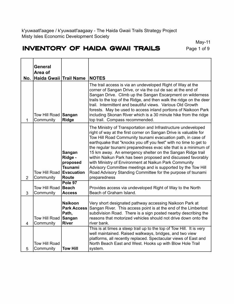
May-11INVENTORY OF HAIDA GWAII TRAILS Page 1 of 9
No.
General Area of Haida Gwaii Trail Name NOTES
1Tow Hill Road Community
Sangan Ridge
The trail access is via an undeveloped Right of Way at the corner of Sangan Drive, or via the cul de sac at the end of Sangan Drive. Climb up the Sangan Escarpment on wilderness trails to the top of the Ridge, and then walk the ridge on the deer trail. Intermittent and beautiful views. Various Old Growth forests. May be used to access inland portions of Naikoon Park including Skonan River which is a 30 minute hike from the ridge top trail. Compass recommended.
2Tow Hill Road Community
Sangan Ridge - proposed Tsunami Evacuation Route
The Ministry of Transportation and Infrastructure undeveloped right of way at the first corner on Sangan Drive is valuable for Tow Hill Road Community tsunami evacuation path, in case of earthquake that "knocks you off you feet" with no time to get to the regular tsunami preparedness evac site that is a minimum of 15 km away. An emergency shelter on the Sangan Ridge trail within Naikun Park has been proposed and discussed favorably with Ministry of Environment at Naikun Park Community Advisory Committee meetings and is supported by the Tow Hill Road Advisory Standing Committee for the purpose of tsunami preparedness
3Tow Hill Road Community
Pole 97 Beach Access
Provides access via undeveloped Right of Way to the North Beach of Graham Island.
4Tow Hill Road Community
Naikoon Park Access Path, Sangan River
Very short designated pathway accessing Naikoon Park at Sangan River. This access point is at the end of the Limberlost subdivision Road. There is a sign posted nearby describing the reasons that motorized vehicles should not drive down onto the river bank.
5Tow Hill Road Community Tow Hill
This is at times a steep trail up to the top of Tow Hill. It is very well maintained. Raised walkways, bridges, and two view platforms, all recently replaced. Spectacular views of East and North Beach East and West. Hooks up with Blow Hole Trail system.
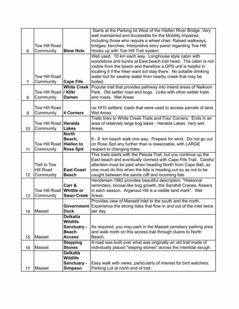
6Tow Hill Road Community Blow Hole
Starts at the Parking lot West of the Hiellen River Bridge. Very well maintained and Accessible for the Mobility Impaired, including those who require a wheel chair. Raised walkways, bridges, benches. Interpretive story panel regarding Tow Hill. Hooks up with Tow Hill Trail system.
7Tow Hill Road Community Cape Fife
Well used. 10 km each way. Longhouse style cabin with woodstove and bunks at East beach trail head. The cabin is not visible from the beach and therefore a GPS unit is helpful in locating it if the hiker want sot stay there. No potable drinking water but for swamp water from nearby creek that may be boiled.
8Tow Hill Road Community
White Creek / Kliki Damen
Popular trail that provides pathway into inland areas of Naikoon Park. Old settler road and bogs. Links with other settler trails and roads. Wet Areas
9Tow Hill Road Community 4 Corners
ca.1910 settlers' roads that were used to access parcels of land. Wet Areas
10Tow Hill Road Community
Heralda Lakes
Trails links to White Creek Trails and Four Corners. Ends in an area of relatively large bog lakes - Heralda Lakes. Very wet Areas.
11Tow Hill Road Community
North Beach, Hiellen to Rose Spit
6 - 8 km beach walk one way. Prepare for wind. Do not go out on Rose Spit any further than is reasonable, with LARGE respect to changing tides.
12
Tlell to Tow Hill Road Community
East Coast Beach
This trails starts with the Pesuta Trail, but you continue up the East beach and eventually connect with Cape Fife Trail. Careful attention must be paid when heading North from Cape Ball, as one must do this when the tide is heading out so as not to be caught between the sands cliff and incoming tide.
13Tow Hill Road Community
Carr & Whittle or Swan Creek
Hendersen 1982 provides beautiful description. "Historical reminders, bonsai-like bog growth, the Sandhill Cranes, flowers in each season. Arganaut Hill is a visible land mark". Wet Areas.
14 MassetGovernment Dock
Provides view of Massett Inlet to the south and the north. Experience the strong tides that flow in and out of the inlet twice per day.
15 Masset
Delkatla Wildlife Sanctuary - Beach Access
As required, you may park in the Masset cemetery parking area and walk north on this access trail through duens to North Beach.
16 MassetStepping Stones
A road was built over what was originally an old trail made of indivdually placed "steping stones" across the intertidal slough.
17 Masset
Delkatla Wildlife Sanctuary - Simpson
Easy walk with views, particularly of interest for bird watchers. Parking Lot at north end of trail.

18
Old Massett Village Council Reserve / Duu Guusd Heritage Site / Conservancy
Kiusta to Lepas Bay Rediscovery Camp
Access trail for the Rediscovery Camp. Rediscovery Camp is managed by the Old Massett Village Council.
19
Old Massett, Yakan Point and Hiellen Indian Reserves
Tl'iellan to Old Masset
Part of Old Massett Economic Development office development plans for the area. Roy Collison, Hereditary Chief of Yakan Point and associated territory envisions economic development opportunity for Yakan Indian Reserve and clan(s). Starts at Hiellen Camp Ground, takes the Blow Hole or Tow Hill Trail, then follows the beach. Access Old Massett via 'Prairie' access road.
20 Watun RiverSkonun Lake
Follows an old settler road directly East from Hwy 16 to Skonun Lake.
21 Nadu
Nadu Road "Evan's Homestead"
From Old Massett Village Council Trails Inventory, ca. 2003 " Take the trail to Masset Inlet at the terminus of Nadu Road. Pass Nadu River over log bridge and former peat moss plant to dock. Follow beach south to hand built rock jetty and enormous rhododendron trees. "
22 Nadu Pure Lake
Access Pure Lake for swimming and day use. Walk through low level bog with associated plants like cloudberry, bunchberry, water lily, Hudson Bay Tea.
23 Nadu
Nadu Homestead (East from Nadu Road)
Straight east of Nadu Road. Settler road that ends at Homestead, Hendersen 1982.
24 Mayor Lake
Mayor Lake Sandy Beach
see Henderson 1982. Only passable in August when water is low. Ends at Sandy Beach. 2 hours 1 way
25 Kumdis RiverKumdis Narrows
see Hendersen p. 31, along the original wagon road, wet, artifacts
26 Port Clements
Francis Evan's Homestead # 2"
From Old Massett Village Council Inventory, ca. 2003 " Take the trail to Masset Inlet at the terminus of Nadu Road. Pass Nadu River over log bridge and former peat moss plant to dock. Follow beach south to hand built rock jetty and enormous rhododendron trees. "
27 Port Clements Golden SpruceYakoun River side trail.
28 Port Clements
Sunset Park Trail and Camp Site
Wheel chair accessible but not for all wheel chairs. Wider tires are required.
29 Port ClementsGovernment Dock
Views of Masset Inlet south and north to the channel. Mobility impaired access. Benches are planned for installation at end of dock. Site of annual children's fishing derby.

30 Port ClementsKumdis River
lovely 15 minute walk to point. Good family walk and picnic area.
31 Tlell Pesuta Trail
Well maintained trail in Naikoon Park. See remains of Pesuta shipwreck. Dunes, intertidal areas, remote feeling, yet close to civilization.
32 Tlell
Misty Meadows Loop
Easy Trail with no inclines. Head to the Beach through Misty Meadows campsite trail, then follow beach to the mouth of the Tlell River, and then come back along the river bank heading upstream, and along Highway 16 back to Misty Meadows campground.
33 Tlell Anvil Tlell River Watershed, minimal maintenance
34 Tlell 3 Mile Creek Tlell River Watershed, Old growth, undeveloped
35 TlellMonique Creek Tlell River Watershed, Old growth, undeveloped
36 TlellOld Growth Alley
Tlell River Watershed, Old Growth, Second Growth, lots of river. Some signage
37 Tlell
Wiggin's Road - Tlell River
From Old Massett Village Council Inventory, ca. 2003, "Trail head located at the end of Wiggins Road. It follows the Tlell River south along the bank, meeting up with the Anvil Trail (~30min). Portions are along privately held land. Long time recreational fishing trail."
38 Lawn Hill Pontoons Tlell River Watershed, Old Settler Road
39 Lawn HillPrettyjohn's Meadow
Tlell River Watershed, Old Settler Roads and trails. Waterfall and historic remains. Walk through 150 year old natural forest, after the" big burn" ca. 1860
40 Lawn Hill
St. Mary's Spring Escarpment
Go up at St. Mary's Spring and follow ridge of the escarpment to Lawn Hill
41
Lawn Hill / Miller Creek / Chinukundle Drain Lake
From Old Massett Village Council Inventory, ca 2003 "From old gravel pit along Highway 16 (Hydro Pole 138) follow tapes 45 minutes through bog and forest to Drizzle Lake. Site has pioneer history and today is recognized as an Ecological Reserve, with ongoing Stickleback fish research."
42
Lawn Hill / Miller Creek / Chinukundle Inside Road
Dalzell Vol.2 1973, p.334. May also be picked out on Google Earth. Hikers do not conflict with ATV users because trail is long and not used so frequently by either user. Trail used for hunting access, and therefore signage at trail heads should address possibility of hunting.
43 Skidegate Spirit Lake
Well maintained by RSTBC. Wheel chair access, but some steep inclines requiring assistance and gravel pathways. Boardwalks, Trail Head and Parking lot in Skidegate Reserve
44 Skidegate
Look-out - Spirit Lake - Heritage Centre Connector and Fork
Recently created hiking trail with views of Skidegate Inlet. Links Spirit Lake to the Haida Heritage Centre at k'ay'llnagaay

45Queen Charlotte
Government Dock
Views of Masset Inlet south and north to the channel. Mobility impaired access. Benches are planned for installation at end of dock. Site of annual children's fishing derby.
46Queen Charlotte
Sleeping Beauty
Well known and revered Alpine Trail. Difficult climbing ins some locations. Spectacular views. "The Sleeping Beauty trail is a popular hiking destination for Queen Charlotte Islands residents and visitors alike. The hike can take anywhere from 2 to 5 hours, or an entire day if you plan on hiking the entire loop. The trail is often muddy after heavy rains, and covered in snow in the winter, so bring the proper equipment.", Google Earth description
47Queen Charlotte
Tarundl Creek Loops
Easy Trail with no inclines. Intertidal in areas. Excellent example of fast growing sitka spruce / coastal hemlock second growth forests.
48Queen Charlotte
Hayden Turner Park
Short trails to intertidal areas through forest. Rocky beaches. Queen Charlotte Cemetery is located in this area.
49Queen Charlotte
Gore Brook loop
Trail used for ecosystem interpretive work by schools over the years. Deer exclosure, Old Growth and second growth. Side hill
50Queen Charlotte
Crabapple Creek
Some structures but not fully maintained. Old Growth forest. Joins with the Backyard trail in 2 spots.
51Queen Charlotte
Charlie Hartie Creek
Lovely Creek side trail accessed form back street of Queen Charlotte. Bisects Backyard Trail. Reference: Over the Hill Hikers Group, Fowler and Weddell, 2011
52Queen Charlotte
Reiger's Lake
Access from Forestry Hill Road. Steep sections. Second growth to Old growth to Lake. Reference: Over the Hill Hikers Group, Fowler and Weddell, 2011
53Queen Charlotte
Backyard Trail
Trail links with other trails such as the Charlie Harty, Crabapple Creek and Gore Brook. Much of this trail appears to run along an old logging skidder road. Side hill all the way. Reference: Over the Hill Hikers Group, Fowler and Weddell, 2011
54
Skidegate Inlet, North West
Mount Slatechuk Mountain side trail promoted by RSTBC
55
Skidegate Inlet North West
Kagan Bay Shoreline
Beach side trail with many access points along the Honna Logging Road.
56
Rennel Sound, West Coast 5 Mile Beach West Coast trail managed by RSTBC
57
Rennel Sound, West Coast
Bonanza Beach
West Coast trail managed by RSTBC. Access Bonanza Beach, Rennel Sound.
58
Rennel Sound, West Coast
Gregory Beach
West Coast trail managed by RSTBC. Access beach at Gregory Creek, Rennel Sound.
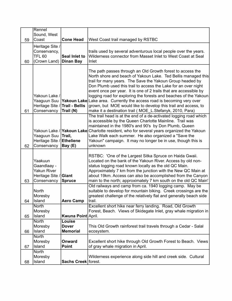
59
Rennel Sound, West Coast Cone Head West Coast trail managed by RSTBC
60
Duu Guusd Heritage Site / Conservancy, TFL 60 (Crown Land)
Seal Inlet to Dinan Bay
trails used by several adventurous local people over the years. Wilderness connector from Masset Inlet to West Coast at Seal Inlet
61
Yakoun Lake / Yaaguun Suu Heritage Site / Conservancy
Yakoun Lake Trail - Bellis Trail (N)
The path passes through an Old Growth forest to access the North shore and beach of Yakoun Lake. Ted Bellis managed this trail for many years. The Save the Yakoun Group headed by Don Plumb used this trail to access the Lake for an over night event once per year. It is one of 2 trails that are accessible by logging road for exploring the forests and beaches of the Yakoun Lake area. Currently the access road is becoming very over grown, but MOE would like to develop this trail and access, to make it a destination trail ( MOE_L.Stefanyk, 2010, Para)
62
Yakoun Lake / Yaaguun Suu Heritage Site / Conservancy
Yakoun Lake Trail, Etheliene Bay (E)
The trail head is at the end of a de-activated logging road which is accessible by the Queen Charlotte Mainline. Trail was maintained in the 1980's and 90's by Don Plumb, Queen Charlotte resident, who for several years organized the Yakoun Lake Walk each summer. He also organized a "Save the Yakoun" campaign. It may no longer be in use, though this is unknown
63
Yaakuun Gaandlaay - Yakun River Heritage Site / Conservancy
Giant Spruce
RSTBC: 'One of the Largest Sitka Spruce on Haida Gwaii. Located on the bank of the Yakoun River. Access by old non-status logging road known locally as the old QC Main. Approximately 7 km from the junction with the New QC Main at about 19km. Access can also be accomplished from the Canyon main to the north; approximately 7 km south on the old QC Main'
64
North Moresby Island Aero Camp
Old railways and camp from ca. 1940 logging camp. May be suitable to develop for mountain biking. Creek crossings are the greatest challenge of the relatively flat and generally beach side trail.
65
North Moresby Island Kwuna Point
Excellent short hike near ferry landing. Road, Old Growth Forest, Beach. Views of Skidegate Inlet, gray whale migration in April.
66
North Moresby Island
Louise Dover Memorial
This Old Growth rainforest trail travels through a Cedar - Salal ecosystem.
67
North Moresby Island
Onward Point
Excellent short hike through Old Growth Forest to Beach. Views of gray whale migration in April.
68
North Moresby Island Sachs Creek
Wilderness experience along side hill and creek side. Cultural forest.

69
North Moresby Island
Sandspit Spit
Excellent fitness opportunity for those who enjoy walking. Views of Hecate Straits, Skidegate Inlet, Airport.
70
North Moresby Island
Cumshewa Head
Part of the Area E of the Skeena Queen Charlotte Regional District Moresby Island Management Committee plan to develop a trail system for North Moresby Island. Forest, Beachcombing and views of Hecate Straits
71
North Moresby Island
Mosquito Mountain Basecamp to West Coast
Alpine Hike to Basecamp near Peak of Mosquito Mountain. Trail used for recreation, interpretation, and fitness by clients form Mount Moresby Adventure Camp.
72
North Moresby Island
Pallant Creek
Trail used for recreation, interpretation, and fitness by clients from Mount Moresby Adventure Camp.
73
North Moresby Island
Pallant Creek 2 (North side Mosquito Lake)
Trail used for recreation, interpretation, and fitness by clients from Mount Moresby Adventure Camp.
74
North Moresby Island
MMAC Lakeside to RSTBC Recreation Site
Mosquito Lake forests are generally composed of second growth, but this trail, which follows the lake side at about 50 m distance, takes you through an area where old growth Red Cedar, Yellow Cedar, Hemlock and Spruce veterans remain within the vigorous regrowth.
75
North Moresby Island
Deer Exclosure access
Access trail to deer exclosure research unit. Branches off of the Pallant Creek trail.
76
North Moresby Island
Mount Moresby
Part of the Area E of the Skeena Queen Charlotte Regional District Moresby Island Management Committee plan to develop a trail system for North Moresby Island. Awesome hike to the highest peak on the Queen Charlotte Islands / Haida Gwaii
77
North Moresby Island Secret Cove
Part of the Area E of the Skeena Queen Charlotte Regional District Moresby Island Management Committee plan to develop a trail system for North Moresby Island. Forest, Beachcombing and views of Hecate Straits
78
North Moresby Island Dogfish Bay
Part of the Area E of the Skeena Queen Charlotte Regional District Moresby Island Management Committee plan to develop a trail system for North Moresby Island. Beachcombing and views of Hecate Straits
TRAILS WITHOUT MAPS
79
North Moresby Island
Heather Lake to Cumshewa Inlet
From Old Massett Village Council Inventory, ca. 2003, "From logging roads at Heather Lake follow trail 1 hr to Cumshewa Inlet. Cumshewa Village is another 3 hrs eastward along the shoreline."

PROPOSED NEW TRAILS OR NEW TRAIL SYSTEMS
80
North East Interior Graham Island
proposed "Bog Walk" Elevated Interpretive
Several long time residents of Masset suggest a new boardwalk style trail be established for bog interpretation. Similar to bog trails in other areas, like lower mainland. High potential for tourism, including wheel chair access as there are no inclines in a bog. Many examples to work from.
81Miller Creek / Chinukundle
Mill 09 Archaeological Forest Trail, proposed
This trail was proposed and received Feasibility Study Funding through the Gwaii Trust Society, but due to the administrative body for the project, the Haida Heritage and Forest Guardians Office, shutting down in 2008, the Study was never completed
82
Haida Gwaii outside of Gwaii Haanas National Park Reserve
Chris Olsen (Queen Charlotte) Conservancy Linkages System
Some trials already exist while others are proposed. Links Conservancies and is an important contribution to the development of a trails strategy for Haida Gwaii
83Queen Charlotte
Skidegate to Queen Charlotte
Over the Hill Hikers Group suggest Queen Charlotte and Skidegate work together to forward this initiative.
84Queen Charlotte
Skidegate Landing to Spirit Lake
Over the Hill Hikers Group suggest Queen Charlotte and Skidegate work together to forward this initiative.
85 Port Clements
Port Clements Hiking Trail North
Generally beach side trail with few inclines. Connects Sunset Park to Port Gas Station at North end of town.
86
Northwest Coast Graham Island
no name yet - west coast trail system linking Old Massett and Skidegate
Described as an Old Massett Village Council, Skidegate Band Council and Council of the Haida Nation joint initiative - John Disney, Old Massett Economic Development Office, 2010
87
Queen Charlotte to Chinukundle Watershed
no name yet
As described in completed questionnaire during the Public Consultation Process for the HG Trails Strategy. Wilderness linkage to Upper Chinukundle watershed. Several ecosystems including Cedar and Yellow Cedar leading Old Growth Forests high level bog. CMTs

DECOMMISSIONED TRAILS
88 Masset
Delkatla Wildlife Sanctuary west side trail
Tidal Action since drainage was amended atMasset causeway has made some trails very muddy and generally not usable.
BICYCLE TRAILS AND LANES
89
North Moresby Island
Alliford Bay Mountain Bike
Previous clearing for mountian bike usage has taken place. More information required. Application of international standard will be appropriate for development of this opportunity: International Mountain Biking Association, IBM website: http://www.imba.com/
90Queen Charlotte
Crabapple Creek Mountain Bike
Previous mountain bike structures and clearing for mountian bike usage has taken place but has been removed in certain places due to liability. Application of international standard will be appropriate for development of this opportunity: International Mountain Biking Association, IBM website: http://www.imba.com/
91
North Moresby Island, Graham Island
Paved Highways maintained under the Ministry of Transport and Infrastructure
As supported by bicyclists during the Pulbic Consultation Process for the HG Trails Strategy, and by the draft Official Community Paln for Area D, Skeena Queen Charlotte Regional District, 2011
All Terrain Vehicle TRAILS
92
Graham Island, North Moresby Island
Deactivated Logging Roads Designated for ATV and Mountain Bike Usage
As described by a Queen Charlotte resident in a completed Questionnaire during the Public Consultation Process for the HG Trails Strategy, 2011. Has potentail to move some ATV's off of sensitive beach ecosystems.
k’yuwaatl’aagee / k’yuwaatl’aagaay / The Haida Gwaii Trails Strategy, Stage 1 Report 2011
Appendix 1: List of Acronyms
GTS: Gwaii Trust Society GFCT: Gwaii Forest Charitable Trust, administrated under the GTS HGTS: Haida Gwaii Trails Strategy Project, k'yuwaatl'aagee / k'yuwaatl'aggay HGSLUA: Haida Gwaii Strategic Land Use Agreement, 2007 MIEDS: Misty Isles Economic Development Society MIMC: Moresby Island Management Committee MMAC: Mount Moresby Adventure Camp Society MoNRO: Provincial Ministry of Natural Resource Operations OHH: Over the Hill Hikers Group, Queen Charlotte OMED: Old Massett Economic Development Office OMVC: Old Massett Band Council RSTBC: Recreational Sites and Trails British Columbia, a branch of the MoNRO SBC: Skidegate band Council SQCRD: Skeena Queen Charlotte Regional District TWS: Tlell Watershed Society
References for the Use of Haida words
1. k'yuwaatl'aagee (gaaw, Old Massett)/ k'yuwaatl'aagaay (hlgayuu, Skidegate): The Path out of concealment / the road out of the woods, Enrico, J., 2005, Lachler, J., 2009. See Bibliography, Entries 20 & 67.
Etymology and ethnography: Personal Communication, Claude Jones of gaaw / old Massett fluent speaker. The project was described to him and he said that k'yuwaatl'aagee fine as a translation for it.
2. kil'uhlaa: (gaaw, Old Massett) to plan, to create a plan, to talk it over and plan it out.
Etymology and ethnography: Personal Communication, Claude Jones of gaaw / Old Massett fluent speaker.
Karen Church, author of this report, is certified by Simon Fraser University as Proficient in First Nations Language (2010). This certification does not indicate fluency. It indicates an understanding of the subject language linguistic system protocols for use. She continues to study the language with Old Massett and Masset area students. She has focused her study on Northern xaad kil, that is, the gaaw xaadee or Old Massett dialect o the Haida Language.


k’yuwaatl’aagee / k’yuwaatl’aagaay / The Haida Gwaii Trails Strategy, Stage 1 Report 2011
Appendix 4: Trails Funding and Development - Internet Resources
1. Trails BC facebook page http://www.facebook.com/TrailsBC
2. International Mountain Biking Association Canada facebook page http://www.facebook.com/TrailsBC 3. Trans Canada Trail http://www.tctrail.ca/home.php 4. Toronto Dominion Friends of the Environment Foundation http://www.fef.td.com/ 5. Mountain Equipment Co-op http://www.mec.ca/Main/content_text.jsp?FOLDER%3C%3Efolder_id=1408474396038943 6. Gwaii Trust Society and Gwaii Forest Charitable Trust http://www.gwaiitrust.com/ http://gwaiiforestcharitabletrust.org/ 7. Misty Isles Economic Development Society Resources webpage http://www.mieds.ca/resources/ This list is a sample of what is available. Funding sources change often and this list should be regularly updated.