kyogle council€¦ · gold coast airport bromelton state development area ballina-byron gateway...
TRANSCRIPT

KYOGLE COUNCIL LOCAL STRATEGIC PLANNING STATEMENT (DRAFT)F e b r u a r y 2 0 2 0

Kyogle Council acknowledges the traditional custodians of this land.
Through respect and collaboration we seek to plan for the future of the local government area as a place in which
Aboriginal people are included socially, economically and culturally, and in which
their history, culture and knowledge is acknowledged and celebrated.

3KYOGLE COUNCIL Draft Local Strategic Planning Statement
Contents
1 About this Statement
Outline and purpose ................................................................................ 4
Relationship with other plans ............................................ 6
How to read this statement ..................................................... 7
2 Context
Location ............................................................................................................................... 8
Connectivity ................................................................................................................ 8
Socio-economic characteristics ................................. 10
Land use and development ................................................ 12
Drivers of change ..................................................................................... 16
Regional Policy ............................................................................................... 18
Local Policy ............................................................................................................. 20
3 Strategic DirectionsVision ................................................................................................................................... 22
Themes and Planning Priorities ............................... 22
Map 1 LGA wide strategic actions map ....................................................................... 27
Map 2 Kyogle town strategic actions map ...................................................................... 28
4 Action PlanProsperity ...................................................................................................................... 29
Housing ............................................................................................................................ 32
Liveability .................................................................................................................... 34
Sustainability ....................................................................................................... 36
5 ImplementationDelivery ........................................................................................................................... 38
Monitoring, reporting and review ........................ 38
References ................................................................................................................ 39

4 KYOGLE COUNCIL Draft Local Strategic Planning Statement

5
1 About this Statement
KYOGLE COUNCIL Draft Local Strategic Planning Statement
Outline and Purpose
The Kyogle Local Strategic Planning Statement (LSPS) is a 20-year vision for land use, development, sustainability and transport in the Kyogle Council Local Government Area (LGA). The LSPS identifies the values and characteristics of the LGA that are important to the community and should be protected. It also identifies issues and trends affecting the region and LGA and proposes strategies to address these. The LSPS describes a vision for the LGA and lists strategies and actions to achieve the vision, to address issues and change, and to make this a better place to live.
The purpose of the LSPS is to:
A. Provide a 20 year land use vision for the LGA.
B. Identify the values and characteristics of our area that are to be enhanced or retained.
C. Identify how growth and change will be managed, including how and where new development will occur.
D. Ensure land use, development, economic and transport strategies are aligned with the North Coast Regional Plan.
E. Identify changes required to planning rules in the Local Environmental Plan (LEP) and Development Control Plan (DCP).
F. Identify further planning work or exercises that are required to support the achievement of the Vision.
Whilst the LSPS is intended to be an overarching plan for Council’s land use planning work, it does not necessarily list all planning exercises or undertakings that may be carried out. From time to time Council may pursue policies or undertake planning exercises or make changes to planning documents that are not listed in the LSPS due to emerging issues or other factors.

6
Relationship with other plans
The LSPS is the highest order strategic land use planning document prepared by Kyogle Council and is intended to set the over-arching vision, priorities and strategies for land use and development in the LGA. It has been drafted to align with and deliver on goals and directions contained in the North Coast Regional Plan. The LSPS also incorporates relevant strategies and
initiatives that are contained in the Kyogle Community Strategic Plan. The strategies and actions in the LSPS will be implemented through statutory plans (LEP and DCP) and further planning exercises which will be mapped out in Council’s 4 year Delivery Program and annual Operational Plan. Figure 1 shows how the LSPS relates to other plans and documents.
KyogleNSW AUSTRALIA
Visi� s of Village Life MALLANGANEE
Vil lage Master Plan
Figure 1 – LSPS and its relationship with other land use planning documents
LOCAL STRATEGIC PLANNING
STATEMENT
Otherplanningstudies Development
ControlPlan
LocalEnvironmental
Plan
KYOGLE COUNCIL Draft Local Strategic Planning Statement
VillageMasterplans

7
How to read this Statement
The LSPS aims to convey the key priorities for land use planning in the Kyogle Council LGA over the next 20 years in a clear and easy to understand way. The LSPS has 5 parts:
• Part 1 provides an introduction to the document and explains its purpose and use.
• Part 2 describes the spatial context of the LGA as well as its socio-economic and physical characteristics, and the trends and issues affecting the LGA. Part 2 also provides a summary of the existing policy context that applies at the regional and local level.
• Part 3 identifies the Vision for the LGA and sixteen Planning Priorities, which are grouped by four themes; Prosperity, Housing, Liveability and Sustainability. Part 3 also includes two maps which show how the Planning Priorities apply spatially over the LGA and Kyogle township.
• Part 4 presents an Action Plan which describes how Council will deliver the sixteen Planning Priorities.
• Part 5 identifies a plan for implementation of the actions proposed within LSPS.
This Plan has been predominantly written using plain English and is designed to be read by any person however, where clarification or further information is sought, please contact Council’s Planning Services section.
KYOGLE COUNCIL Draft Local Strategic Planning Statement

Location
The Kyogle LGA is located in the North Coast region of New South Wales. The LGA has an area of 3,589 square kilometres. The Richmond Range divides the LGA into two major river catchments; the Richmond in the east and the Upper Clarence in the west. The LGA adjoins the local government areas of Tenterfield Shire, Lismore City, Tweed Shire, Richmond Valley and Clarence Valley. The northern boundary of the LGA adjoins the Scenic Rim Regional Council area in Queensland.
Connectivity
On the face of it, the Kyogle LGA appears remote from regional and interstate growth centres. In reality, however, the municipality benefits from excellent road and rail linkages and easy access to airports with both domestic and international connections.
Major road connections include the Summerland Way which runs from Grafton in the south through Kyogle township to meet the Mount Lindesay Highway near the
State border. The Mount Lindesay Highway then provides connection to Queensland including to the Darling Downs and Brisbane West Wellcamp Airport in Queensland to the north-west, and Beaudesert and the greater Brisbane region to the north-east. The Bruxner Highway provides an east-west connection from Tenterfield to Casino and passes through Tabulam and Mallanganee. Bentley Road provides a connection to Lismore (which is designated a Regional City in the North Coast Regional Plan) and the M1 Motorway. Kyogle Road provides a connection to Murwillumbah, the M1 Motorway and the Gold Coast.
The Sydney to Brisbane rail line which passes through Kyogle provides freight and passenger services including connections to the Bromelton State Development Area just outside Beaudesert, Brisbane city, the Port of Brisbane and Brisbane Airport. The future Inland Rail line will pass through Kagaru (near Beaudesert) with a connection to the Brisbane-Sydney line, which will further increase locations and markets that are accessible by rail. Figure 2 page 9 – shows the Kyogle Council LGA and its regional context and connections.
2 Context
This section outlines the key characteristics of the Kyogle LGA. It identifies the opportunities and issues that we will address in planning for the sustainable development of our communities. It also outlines those elements of the existing policy framework that guide planning and development activity across the region and within the municipality.
8 KYOGLE COUNCIL Draft Local Strategic Planning Statement

9
KYOGLE COUNCIL
LGA
BRISBANE
Toowoomba
Brisbane Airport
Gold Coast Airport
Bromelton StateDevelopment Area
Ballina-ByronGateway Airport
Brisbane WestWellcamp
Airport
.Warwick
.e erfie
. e es
Capital City (State)
Regional City
Town
Airport
Port
Bromelton StateDevelopment Area
Motorway
Highway, Major Road
Brisbane-Sydney Rail
Inland Rail
KyogleCouncil LGA
State Border
.Grafton
. as o
. ur u a
QLDNSW
o oas
ee ea s
.Byron Bay
. a a.
.
a u a
. o a o
. oo e o g
yog e
. eau eser
s oreLismore Airport
★
▲
Figure 2 – Kyogle Council LGA and its regional context and connections
KYOGLE COUNCIL Draft Local Strategic Planning Statement

10
Socio-economic characteristics
The statistics below illustrate the socio-economic characteristics of the Kyogle Council LGA.
The estimated resident population of the Kyogle Council LGA in 2019 is 9,167.
The forecast population of the LGA in 2041 is 10,246.
9,167 10,246
Population
Age structure
The Kyogle Council LGA has a higher proportion of persons aged 50-69 than the Regional NSW average, and a lower proportion of persons aged 20-44.
Source: Australian Bureau of Statistics, Census of Population and Housing, 2016 (Enumerated data). Compiled and presented in profile .id by .id, the population experts.
% o
f tot
al p
eopl
e
Age Group (years)
Kyogle Council Area Regional NSW12
10
8
6
4
2
00-4 5-9 10-14 15-19 20-24 25-29 30-34 35-39 40-44 45-49 50-54 55-59 60-64 65-69 70-74 75-79 80-84 85-89
Total persons (five year age groups – 2016)
KYOGLE COUNCIL Draft Local Strategic Planning Statement

11
Housing
The average household size is 2.25 persons per household which is lower than the NSW State average of 2.61. The local housing stock is substantially comprised of detached dwellings. The proportion of smaller dwellings is lower than the Regional NSW average.
% o
f dw
ellin
gs
Structure type
Kyogle Council Area Regional NSW100
75
50
25
0Separate House Medium
DensityHigh
DensityCaravans, cabin
HouseboatOther
Dwelling Structure, 2016
Source: Australian Bureau of Statistics, Census of Population and Housing, 2016 (Enumerated data). Compiled and presented in profile .id by .id, the population experts.
Local Economy
The gross local product was $313 million in 2018. The top 5 industries by output and employment are shown below.
Agriculture, Forestry & Fishing
Construction
$70M
Rental, Hire & Real Estate
$30M
$
Education & Training
$70M
329
Construction
Manufacturing
$73M
257
Education & Training
$125M
670
Agriculture, Forestry & Fishing
216
Health Care
Top 5 industries by value generated
Top 5 industries by employment
232
Manufacturing
KYOGLE COUNCIL Draft Local Strategic Planning Statement

12
Land use and development
The Kyogle Council LGA is a predominantly rural municipality within which are located a number of interspersed towns and villages. The following is an outline of land use and development in the different areas of the LGA.
Rural areas
The non-urban areas of the LGA consist primarily of cleared and vegetated land that is used for a variety of agricultural and rural living purposes. The primary agricultural activity in the LGA is cattle grazing which is suited to the predominantly undulating and hilly terrain of the LGA. River and creek flats are utilised for growing a range of crops including maize, silage and hay, oats, soy beans and rice as well as for dairying. Other crops grown include nuts (pecans and macadamias), coffee, fruit, blueberries and avocados. Intensive livestock agriculture is also carried out, primarily being the raising of pigs in conventional indoor piggeries.
State Forests and National Parks make up approximately 30% of the land area of the Kyogle Council LGA. National Parks are primarily located on significant ranges including the Richmond Range, the Border Ranges, Haystack Mountain and Mallanganee Range. These National Parks include World Heritage listed sub-tropical, dry and warm-temperate rainforest.
State Forests in the Kyogle Council LGA consist of both native and plantation (hardwood and softwoods) forests and are principally managed for timber production. These State Forests also function as recreational areas and offer opportunities for four-wheel driving, motorbike riding, mountain bike riding, camping and horse riding. In certain locations State Forests also accommodate low-intensity grazing and bee-keeping.
The other predominant use of rural land in the LGA is for rural living, which takes place on acreage or small scale ‘hobby’ farms, as well as on larger parcels of managed and substantially vegetated land.
KYOGLE COUNCIL Draft Local Strategic Planning Statement

13
Kyogle town
The principal urban centre in the Kyogle Council LGA is Kyogle township. It has a population of approximately 3,000 persons and offers an extensive range of services, facilities and employment opportunities. Kyogle is located on the Summerland Way and the Brisbane to Sydney rail line. It is also located on the Richmond River and its lower-lying areas are prone to significant flooding.
Services and facilities: Kyogle has a comprehensive range of services and facilities including; a hospital and aged care facility, two primary schools and a high school, banks, supermarket and numerous professional and personal services, sporting clubs and other places of entertainment.
Residential development: Kyogle’s residential stock is comprised principally of detached dwellings with a limited number
of units and smaller dwellings. There is also an aged care facility offering 64 beds. The three main residential areas are within the main area of Kyogle as well as at Highfield and Geneva. A number of rural residential areas exist on the fringes of town.
Business and industry: Kyogle accommodates a range of light and general industries, including sawmills and timber processing, concrete works, agricultural produce industries and manufacturing of rural products. These businesses are located principally in four industrial and rural zoned areas within the town and on its fringes. The central commercial area of Kyogle features accommodates numerous business premises including retail outlets, food and drink premises and personal and professional services. A number of light industrial, health care and education establishments are located in different areas outside of the business centre.
KYOGLE COUNCIL Draft Local Strategic Planning Statement

14
Figure 3 – Land Use Zoning of Kyogle town and surrounds
Future development: The Kyogle LEP applies land use zones to land in the LGA to designate its intended use or purpose. Kyogle has approximately 125 ha of vacant land zoned for residential development.
Kyogle has approximately 82 ha of vacant land zoned for industrial use. Kyogle has approximately 11 ha of land zoned for business or retail activities of which very little is vacant.
KYOGLE COUNCIL Draft Local Strategic Planning Statement
Key to Land Use ZonesRU1 Primary productionRU2 Rural landscapeRU3 Forestry
RU4 Primary production small lotsR1 General residentialR5 Large lot residentialRE1 Public recreation
IN1 General industrialIN2 Light industrialB2 Local centreB4 Mixed use

Other towns and villages
The Kyogle Council LGA features a number of smaller towns and villages. Bonalbo and Woodenbong are two small towns located in the upper Clarence River catchment that are serviced by reticulated water and sewerage as well as piped stormwater drainage. Both towns have a range of retail offerings and household and professional services as well as public and sporting facilities. Both towns have a central school and police station, Bonalbo also features an ambulance station and hospital. Both Bonalbo and Woodenbong are served by campground/caravan parks, which cater for a growing number of visitors to the area. Bonalbo and Woodenbong both have a small amount of vacant land zoned for development and opportunities for infill development. Both towns also each feature an area of rural residential zoned land on their peripheries.
Tabulam is located at the intersection of the Bruxner Highway and Clarence River.
Tabulam offers a basic range of retail services as well as a post office, hotel and primary school. Mallanganee, Old Bonalbo, Wiangaree, Grevillea, Mummulgum and Cawongla are small villages that offer a small range of services and retail facilities. Old Bonalbo, Wiangaree and Mummulgum each have a primary school. None of these villages are serviced by reticulated water or sewerage. Some of these villages have vacant land that is zoned for development and opportunities for infill development however, lack of infrastructure constrains development potential.
In 2018 Council prepared and adopted masterplans for the villages of Bonalbo, Mallanganee, Old Bonalbo, Tabulam, Wiangaree and Woodenbong which outline key villages improvement projects and guide the use and management of community lands in the villages.
15KYOGLE COUNCIL Draft Local Strategic Planning Statement

16
• Kyogle is a well-established subregional service centre with a comprehensive range of services, facilities and institutions.
• Many other areas of the LGA have access to a good level of local services and amenities available in villages, including; pools, halls, post offices, hospitals, schools, ambulance stations and police stations.
• Improving and more resilient infrastructure.
• Engaged and active community – social capacity to support growth.
• Relatively affordable land and housing.
• A strong agricultural sector.
• Attractive and productive rural landscape.
• Forecast population growth.
Drivers of change
There are a number of key issues that will have a bearing on the future development of the Kyogle LGA.
Our advantages – The Kyogle Council LGA has a number of qualities that offer natural advantages, including:
• Proximity to South-East Queensland, including the Bromelton State Development Area near Beaudesert presents opportunity for growth in investment and trade, tourism and inward migration.
• Our World Heritage places, National Parks and State Forests offer potential to increase tourism and visitation, and contribute to an image of the LGA as a clean, green environment in which to farm or choose to live.
• The availability of land surrounding existing towns and villages offers potential for development of new residential and industrial/commercial areas.
• We are part of the Northern Rivers brand which projects a clean, green, desirable image.
• Our improving inter-regional and inter-State connectivity offers opportunities to increase trade and investment, and to increase the desirability of Kyogle as a place to live and work.
• Improving digital connectivity and services which may result in improved opportunities for telecommuting and tele-health.
Our opportunities – In addition to our natural advantages, the Kyogle LGA has a number of opportunities:
KYOGLE COUNCIL Draft Local Strategic Planning Statement

Our challenges – We must plan effectively to address the following challenges:
External and emerging factors – There are a number of external and emerging factors that require consideration in planning for future land use, economic development, settlements and environmental management, including:
17
• Natural disasters and the effects of climate change.
• High length of road to population ratio.
• Demographic profile – high proportion of older persons.
• Lack of diversity in local economy.
• Patchy (but improving) digital connectivity.
• Declining population in western part of LGA.
• Water security in urban and rural areas – projected increasing variability in rainfall, and severity and frequency of drought may lead to water scarcity.
• Deficiency in housing choice and supply – this is a barrier to relocation and retention.
• A relatively high level of social and economic disadvantage.
• The growing population of south-east Queensland. This is likely to create increased tourism and visitation and influence our population level.
• Improving access to agricultural export markets (eg. Asia).
• Decreasing affordability in coastal areas – this may influence people to move to or buy in Kyogle LGA.
• Climate change – the effects predicted for the Northern Rivers include an increased number of days over 35° Celsius, a decrease in the number of nights less than 2° Celsius, increase in severe fire weather and altered rainfall patterns. Council’s land use planning needs to consider this.
KYOGLE COUNCIL Draft Local Strategic Planning Statement

18
Regional policy
The North Coast Regional Plan 2016-2036 (Department of Planning and Environment, 2016) is the overarching strategic plan that applies to the North Coast region and provides a statement of land use, economic
development, environmental protection, infrastructure provision and community development policy. The goals and directions of the North Coast Regional Plan (NCRP) are outlined below.
GOAL 1: The most stunning environment in NSWDirection 1: Deliver environmentally
sustainable growth
Direction 2: Enhance biodiversity, coastal and aquatic habitats, and water catchments
Direction 3: Manage natural hazards and climate change
Direction 4: Promote renewable energy opportunities
GOAL 2: A thriving, interconnected economy Direction 5: Strengthen communities of
interest and cross-regional relationships
Direction 6: Develop successful centres of employment
Direction 7: Coordinate growth of regional cities
Direction 8: Promote the growth of tourism
Direction 9: Strengthen regionally significant transport corridors
Direction 10: Facilitate air, rail and public transport infrastructure
Direction 11: Protect and enhance productive agricultural lands
Direction 12: Grow agribusiness across the region
Direction 13: Sustainably manage natural resources
GOAL 3: Vibrant and engaged communities Direction 14: Provide great places to live and
work Direction 15: Develop healthy, safe, socially
engaged and well-connected communities
Direction 16: Collaborate and partner with Aboriginal communities
Direction 17: Increase the economic self-determination of Aboriginal communities
Direction 18: Respect and protect the North Coast’s Aboriginal heritage
Direction 19: Protect historic heritageDirection 20: Maintain the region’s distinctive
built characterDirection 21: Coordinate local infrastructure
delivery
GOAL 4: Great housing choice and lifestyle options Direction 22: Deliver greater housing supplyDirection 23: Increase housing diversity and
choiceDirection 24: Deliver well-planned rural
residential housing areasDirection 25: Deliver more opportunities for
affordable housing
VISION The best region in Australia to live, work and play thanks to its spectacular environment and vibrant communities
KYOGLE COUNCIL Draft Local Strategic Planning Statement

The NCRP includes the following priorities that apply specifically to the Kyogle Council LGA:
19
• Grow agricultural links along the Summerland Way corridor to south-east Queensland to maximise connections with national and international markets.
• Support the important local grazing, dairy, cropping and horticultural industries and promote new opportunities for agribusiness.
• Identify opportunities to expand nature-based adventure and cultural tourism places and enhance visitor experiences within areas such as the Border Ranges.
• Development employment land at Kyogle.
• Maximise opportunities associated with the Brisbane West Wellcamp Airport and the expansion of the Bromelton State Development Area to support Kyogle’s agricultural sector.
• Protect important farmland at Kyogle, Wiangaree, Cedar Point, Edenville, Dyraaba Central, Roseberry Creek, Robinvale, Old Grevillea and Eden Creek.
• Deliver housing to the northern, eastern and southern fringes of Kyogle.
• Support the village and rural lifestyle of Woodenbong, Bonalbo, Tabulam, Mummulgum, Cawongla, Old Bonalbo, Geneva, Wiangaree and Mallanganee.
KYOGLE COUNCIL Draft Local Strategic Planning Statement

20
The highest-level expression of Council’s strategic priorities is established in the Community Strategic Plan 2016-2026. The CSP is based on five themes which are outlined below, together with their key policies and strategies that are related to land use planning.
Local policy
Governance and community services
The sustainable management of roads, bridges and other infrastructure
Ageing in place, disability services and respite care
Promote social equity and inclusion
Increase the supply of adaptable and appropriate housing
Advocate for services to support older persons and persons with a disability to live in their communities
Achieve equitable access to public places and commercial precincts
Ensure sufficient infrastructure to support older persons and persons with a disability
Agriculture
Expand agricultural business opportunities
Enhance the economic viability of agriculture
Encourage sustainable land management practices that will ensure the long term sustainability of agriculture and the environment
Ensure infrastructure is adequate to support agricultural activities
Visitor attraction
Enable access to places of interest in National Parks and State Forests
Develop a Destination Management Plan and Visitor Economy Strategy
Develop and promote events that attract visitors
Village life
Develop a vision for urban renewal
Identify and create opportunities for economic development
Support innovation with respect to environmentally and socially sustainable development
Conservation and celebration of heritage to promote village or place identity
VISION Working together to balance environment, lifestyle and opportunity
KYOGLE COUNCIL Draft Local Strategic Planning Statement

This LSPS is cognisant of and aligned with the priorities in the CSP, many of which have land use planning implications (for example, to review and amend the Kyogle Local Environmental Plan to support economic growth). Council will be required to develop a new Community Strategic Plan following local elections in September 2020 and this will provide an opportunity to further strengthen the relationship between the LSPS and Council’s overarching strategic framework.
In the past few years Council has completed a number of planning exercises that respond to the NCRP and the CSP, including:
• The development and adoption of masterplans for six villages.
• Preparation and adoption of the Kyogle Mountain Bike Trail Development Strategy.
• An amendment to the LEP to allow temporary workers accommodation to be development in rural areas to support agriculture.
• An amendment to the LEP to allow short-term events to be approved as ‘complying development’.
In addition to the above, Council continues to advocate for support and investment to deliver strategic initiatives that will unlock the development potential of the region (for example, transport infrastructure upgrades). Other measures to stimulate development, including the adoption of an interim Developer Discount Policy, have also been introduced – and have been instrumental in supporting the local construction sector. The LSPS provides a mechanism to review and, where appropriate, embed these initiatives within the long term land use planning framework for the Kyogle LGA.
21KYOGLE COUNCIL Draft Local Strategic Planning Statement

Our Vision
The Kyogle Local Government Area is a special place. We recognise and value the remarkable attributes of this place and its people – and we plan for a sustainable, equitable and competitive future for our communities.
Our Vision statement is concise. It conveys our firm belief that the Kyogle LGA is a precious place that merits the highest standards of stewardship, planning and place making.
Our Vision statement is values-driven. It underscores our commitment to ensure that our people are empowered through access to a full range of choices and opportunities.
Our Vision is deliverable. It is underpinned by actions that will bring about sustainable, positive change.
Themes and Planning Priorities
The Kyogle LSPS has four overarching key themes which provide a framework for action over the lifetime of the Statement:
Prosperity
Housing
Liveability
Sustainability
These themes have been developed to respond to the particular challenges and opportunities identified in the preceding section, and also align with adopted and emerging regional and local policy. In this way, the Kyogle LSPS is a coherent extension of existing policy and articulated community priorities – it provides for continuity in planning and action over the long term.
This section of the LSPS outlines the four themes and articulates planning priorities that sit within each theme.
3 Strategic Directions
This LSPS is intended to be locally-distinctive. It articulates that which is particular to the Kyogle Council LGA, and proposes actions that will deliver the change that our communities need in order to ensure that they are the vibrant places that our people deserve.
22 KYOGLE COUNCIL Draft Local Strategic Planning Statement

The safeguarding and creation of jobs is an essential precursor to sustainable local growth. As previously identified, the Kyogle LGA has been out of step with the levels of population and
economic growth experienced elsewhere in the Northern Rivers region over recent years. Negative growth places pressure on existing services, businesses and facilities and actively militates against inward investment.
The adoption of the LSPS with job creation ‘front and centre’ sends a clear message that Council will work to establish a proactive land use planning framework that will build
confidence in Kyogle as a competitive location for investment and development.
The following Planning Priorities are proposed to contribute to the Prosperity of the LGA.
PLANNING PRIORITY
Priority A1 Support growth and diversification of our agricultural sector
Priority A4 Create the right conditions to support enterprise and innovation
Priority A3 Support sustainable growth of the visitor economy
CONSISTENT WITH EXISTING POLICIES?
Yes. Growing and diversifying agriculture is a direction of the NCRP, Regional Economic Development Strategy (REDS) and CSP.
Yes. Supporting the growth of business is a direction of the NCRP and REDS.
Yes. Growing the visitor economy is a direction of the NCRP, REDS and CSP.
RATIONALE OR NEED FOR THIS PRIORITY
Agriculture is a key part of the local economy, yielding the highest numbers of jobs (together with forestry) and the highest economic output. There is significant potential for growth and diversification through growing markets and innovation. Productive agricultural land, access to water and a skilled and knowledgeable workforce are key assets of the Kyogle Council area.
Council seeks to support the ability of business to establish and grow though ensuring sufficient land is available for development, development is permissible and infrastructure is available to support development.
Whilst the Kyogle Council LGA has features which are attractions for tourists and visitors, including World Heritage areas, National Parks, State Forests, an attractive rural landscape and outdoor recreation opportunities, the LGA presently offers limited tourism-focussed infrastructure, services, businesses and experiences. The LGA adjoins South-East Queensland which has a large, growing population. Accordingly, there is significant potential to increase tourism and visitation.
Priority A2 Support key strategic and cross border transport initiatives
Yes. Improving connectivity to external markets is a direction of the NCRP, REDS, Northern Rivers Joint Organisation (NRJO) Strategic Regional Priorities and CSP.
Improving connectivity into South-east Queensland will provide greater opportunity to access markets, processing facilities and transport links and hubs including the Port of Brisbane, Bromelton State Development Area and the future Inland Rail line. It will also improve the connection to productive agricultural land in the Darling Downs.
previously identified, the Kyogle LGA has been out of step with the levels of population and economic growth experienced elsewhere in the Northern Rivers region over recent years.
confidence in Kyogle as a competitive location for investment and development.
The following Planning Priorities are proposed to contribute to the Prosperity of the LGA.
Prosperity
23KYOGLE COUNCIL Draft Local Strategic Planning Statement

24
This LSPS will create the right conditions for growth and extending choice in the local housing market. It builds upon our existing knowledge of the key structural issues that need to be addressed in
order to provide the accommodation options required by our communities.
Relative to neighbouring districts, housing prices are very competitive within the Kyogle LGA. However, yields on residential development have been lower than elsewhere in the region – with the attendant impact that there has been low growth in terms of new, market housing. In addition, there is insufficient choice within the local housing market
to cater for the needs of the current and predicted population of the area. The forecast demographic profile of Kyogle continues to show strong representation in the older cohorts
– this will dictate that demand will grow for smaller housing units coupled with good access to facilities and support services. The following Planning Priorities are proposed to contribute to the Housing needs of the LGA.
PLANNING PRIORITY
Priority B1 Plan for appropriately located and designed residential development
Priority B2 Plan to provide greater housing choice for our community
Priority B3 Empower Aboriginal communities to plan for the development and management of their land
Priority B4 Ensure that infrastructure is delivered to meet the needs of the community
CONSISTENT WITH EXISTING POLICIES?
Yes. Planning for appropriately designed and located housing is a direction in the NCRP, REDS and CSP.
Yes. Delivering greater housing choice is a direction of the NCRP, NRJO Strategic Regional Priorities and CSP.
Yes. This is a specific Direction of the NCRP.
Yes. Delivery of infrastructure to support development is a direction of the NCRP and REDS.
RATIONALE OR NEED FOR THIS PRIORITY
New residential development should be designed to avoid natural hazards and impacts on ecological values, watercourses and good quality agricultural land. New residential areas should also have good accessibility to services and facilities. New residential development should be responsive to the local climate and character.
The Kyogle Council LGA currently has a lack of diversity in the size and type of housing available. A range of dwelling sizes and types are required to cater for different people, different life stages, household composition and physical abilities. Kyogle Council will plan to deliver a greater range of housing types and sizes to meet the diverse needs of the population.
Land owned by Local Aboriginal Land Councils within the Kyogle Council LGA represents an opportunity to contribute to the economic self-determination of local Aboriginal people. It is NSW Government policy to assist economic self-determination through realising opportunities afforded by land holdings.
Development needs to be serviced by adequate and appropriate infrastructure. Infrastructure delivery must be planned for delivery in conjunction with development.
It builds upon our existing knowledge of the key structural issues that need to be addressed in order to provide the accommodation options required by our communities.
to cater for the needs of the current and predicted population of the area. The forecast demographic profile of Kyogle continues to show strong representation in the older cohorts
– this will dictate that demand will grow for smaller housing units coupled with good access to facilities and support services. The following Planning Priorities are proposed to contribute to the
Housing
KYOGLE COUNCIL Draft Local Strategic Planning Statement
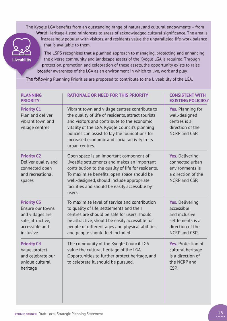
The Kyogle LGA benefits from an outstanding range of natural and cultural endowments – from World Heritage-listed rainforests to areas of acknowledged cultural significance. The area is
increasingly popular with visitors, and residents value the unparalleled life-work balance that is available to them.
The LSPS recognises that a planned approach to managing, protecting and enhancing the diverse community and landscape assets of the Kyogle LGA is required. Through
protection, promotion and celebration of these assets, the opportunity exists to raise broader awareness of the LGA as an environment in which to live, work and play.
The following Planning Priorities are proposed to contribute to the Liveability of the LGA.
PLANNING PRIORITY
Priority C1 Plan and deliver vibrant town and village centres
Priority C2 Deliver quality and connected open and recreational spaces
Priority C3 Ensure our towns and villages are safe, attractive, accessible and inclusive
Priority C4 Value, protect and celebrate our unique cultural heritage
CONSISTENT WITH EXISTING POLICIES?
Yes. Planning for well-designed centres is a direction of the NCRP and CSP.
Yes. Delivering connected urban environments is a direction of the NCRP and CSP.
Yes. Delivering accessible and inclusive settlements is a direction of the NCRP and CSP.
Yes. Protection of cultural heritage is a direction of the NCRP and CSP.
RATIONALE OR NEED FOR THIS PRIORITY
Vibrant town and village centres contribute to the quality of life of residents, attract tourists and visitors and contribute to the economic vitality of the LGA. Kyogle Council’s planning policies can assist to lay the foundations for increased economic and social activity in its urban centres.
Open space is an important component of liveable settlements and makes an important contribution to the quality of life for residents. To maximise benefits, open space should be well-designed, should include appropriate facilities and should be easily accessible by users.
To maximise level of service and contribution to quality of life, settlements and their centres are should be safe for users, should be attractive, should be easily accessible for people of different ages and physical abilities and people should feel included.
The community of the Kyogle Council LGA value the cultural heritage of the LGA. Opportunities to further protect heritage, and to celebrate it, should be pursued.
World Heritage-listed rainforests to areas of acknowledged cultural significance. The area is increasingly popular with visitors, and residents value the unparalleled life-work balance
protection, promotion and celebration of these assets, the opportunity exists to raise broader awareness of the LGA as an environment in which to live, work and play.
The following Planning Priorities are proposed to contribute to the Liveability of the LGA.
Liveability
25KYOGLE COUNCIL Draft Local Strategic Planning Statement

26
The Kyogle LGA is forecast to experience manageable growth during the period of this LSPS. In this regard, the municipality will be transitioning from a period of population decline – with attendant low
growth and development rates – to a phase where expansion and diversification of key centres is anticipated. The local strategic planning framework will need to balance competing
interests associated with growth and development on the one hand, with conservation and environmental protection on the other.
The acknowledged biodiversity value of the area dictates that development will need to be carefully managed and located to ensure no unacceptable adverse impacts on
the special environment of the Kyogle LGA. In addition, increasing climate instability is exacerbating the range and frequency of natural hazards with which our communities must
contend. The LSPS promotes a range of actions that will help to conserve critical environmental assets and help to protect our communities in times of increased risk.
The following Planning Priorities are proposed to contribute to the Sustainability of the LGA.
PLANNING PRIORITY
Priority D1 Protect and enhance areas of high environmental value and biodiversity
Priority D2 Protect and enhance the health of the Richmond and Clarence catchments
Priority D3 Protect communities from the risks associated with natural hazards
Priority D4 Plan for adaption to, and mitigation of, the effects of climate change
CONSISTENT WITH EXISTING POLICIES?
Yes. Protection of environmental values is a direction of the NCRP and NRJO Strategic Regional Priorities.
Yes. Enhancement of river health is a direction of the NCRP and NRJO Strategic Regional Priorities.
Yes. Avoidance of natural hazards is a direction of the NCRP.
Yes. Planning for climate change is a direction of the NCRP.
RATIONALE OR NEED FOR THIS PRIORITY
Areas of high environmental value and biodiversity provide ecosystem services and contribute to the quality of life for residents as well as serving as an attractor to tourists and visitors. Protection of these values and resources is therefore important.
The Richmond and upper Clarence River catchments presently display poor to average catchment health and water quality, particularly in the Richmond River. Strategies to enhance catchment health and water quality are required.
Responsible land use planning seeks to ensure that development is responsive to natural hazards in order to ensure the safety and livelihood of future residents and users is not threatened.
The forecast effects of climate change pose significant threats to biodiversity, public infrastructure, agriculture and community wellbeing and safety. Planning for adaption and mitigation is therefore important.
growth and development rates – to a phase where expansion and diversification of key centres is anticipated. The local strategic planning framework will need to balance competing
interests associated with growth and development on the one hand, with conservation and
the special environment of the Kyogle LGA. In addition, increasing climate instability is exacerbating the range and frequency of natural hazards with which our communities must
contend. The LSPS promotes a range of actions that will help to conserve critical environmental assets and help to protect our communities in times of increased risk.
Sustainability
KYOGLE COUNCIL Draft Local Strategic Planning Statement

27KYOGLE COUNCIL Draft Local Strategic Planning Statement
MAP 1 – LGA wide strategic actions map
(Note: actions highlighted yellow are not applicable to specific locations)
OLD BONALBO
BONALBO
TABULAMMALLANGANEE
Mallanganee NP
Richmond Range NP
KYOGLE
WIANGAREE
CAWONGLASEE MAP 2
Key to Actions
A1.3 Amend the LEP to introduce a single rural land
use zone
A1.4 Undertake an assessment to establish the need for a range of lot sizes to support diverse agricultural pursuits
A1.5 Amend the LEP to facilitate diversification of
agriculture and value-adding opportunities
A2.1
Support and advocate for planning and delivery of a new State border crossing and improvements to the Summerland Way and Mount Lindesay Highway
A2.2 Advocate for improvements to the Clarence Way
and to provide B-double access between Casino and Tabulam via the Bruxner Highway
A2.3 Advocate for improvements to freight and
passenger rail services
A3.1 Amend the LEP to allow additional tourism-based
development in rural areas
C1.4 Continue to implement the actions from adopted
village masterplans
C2.4 Support and advocate for improved access to
State Forests and National Parks to support recreation and tourism
D1.1 Amend the LEP to introduce a biodiversity overlay
D2.2 Advocate for better catchment management and
promote improved land management practices to improve water quality and river health
D2.4 Amend the LEP to protect riparian land,
watercourses and wetlands
LegendMajor roadRailwayTown or villageNational ParkState ForestLGA boundaryRiver or creekPotential border crossing
A2.1
A2.1
A2.3
A2.2
C1.4
C1.4
C1.4
C1.4
C1.4
C1.4
A2.1
A2.2
WOODENBONG
Toonumbar NP
Yabbra NP
Border Ranges NP

Key to Actions
Amend the LEP to allow artisans and crafts persons enterprises and appropriate residential development in Zone B2
Amend the DCP to provide criteria for development in Zone B2 and B4
Prepare masterplans for the Kyogle civic precinct and wider CBD
Work with Transport for NSW in regard to planning and delivery of the Kyogle CBD heavy vehicle bypass
28 KYOGLE COUNCIL Draft Local Strategic Planning Statement
MAP 2 – Kyogle strategic actions map
Key to Land Use Zones
B2 Local centreB4 Mixed useRE1 Public recreationR3 Medium density residential
C1.1
C1.1
C1.3C1.3
C1.3
C1.5
C1.5
C1.2
C1.2

29
4 Action PlanThe following tables outline an Action Plan to achieve the Planning Priorities identified previously. The Actions will be carried out by Council through further planning work, strategy development or as specific actions. The tables also identify who is responsible for undertaking the Actions and Timeframes within which they are proposed.
KYOGLE COUNCIL Draft Local Strategic Planning Statement

ACTION
Ongoing
Ongoing
Ongoing
RESPONSIBILITY
Council
Council
Council
TIMEFRAME
A2.1 Support and advocate for planning and delivery of a B-Double access route on the State border crossing and improvements to the Summerland Way and Mount Lindesay Highway
A2.2 Support and advocate for improvements to the Clarence Way and to provide B-Double access between Casino and Tabulam via the Bruxner Highway
A2.3 Support and advocate for improvements to freight and passenger rail services
Support key strategic and cross border transport initiatives
30 KYOGLE COUNCIL Draft Local Strategic Planning Statement
ACTION
Ongoing
Ongoing
Immediate
Immediate
Medium term
RESPONSIBILITY
Planning Services
Assets and Infrastructure
Planning Services
Planning Services
Planning Services
TIMEFRAME
A1.1 Protect good quality agricultural land from incompatible development and fragmentation
A1.2 Advocate for, and where appropriate, deliver infrastructure to support agribusiness
A1.3 Amend the Kyogle LEP to introduce a single rural land use zone (RU1) and biodiversity overlay
A1.4 Undertake an assessment to establish the viability and need for a range of/smaller lot sizes to support diverse agricultural pursuits
A1.5 Amend the Kyogle LEP to facilitate diversification of agriculture and provide opportunities for value-adding to existing agricultural enterprises
Planning Priority A1
Planning Priority A2
Support growth and diversification of our agricultural sector

31
ACTION
Short term
Short term
Short term
Medium term
RESPONSIBILITY
Planning Services
Planning Services
Planning Services, Strategic Initiatives
Planning Services, Strategic Initiatives
TIMEFRAME
A3.1 Amend the LEP to allow additional appropriate types of tourist accommodation, development and activities to support agritourism in rural areas
A3.2 Review LEP and DCP provisions to support appropriate tourism development
A3.3 Consult with Native Title claimants and other aboriginal organisations to ascertain their cultural tourism aspirations
A3.4 Research and prepare a Tourism Development Strategy
Support sustainable growth of the visitor economy
ACTION
Ongoing
Medium term
Medium term
Medium term
Medium term
RESPONSIBILITY
Strategic Initiatives
Planning Services
Planning Services
Planning Services, Assets and Infrastructure
Planning Services
TIMEFRAME
A4.1 Identify opportunities to increase inward investment and to support growth of existing businesses and industries
A4.2 Prepare an Employment Land Demand Analysis to determine requirements for business and industrial land supply
A4.3 Amend the LEP to ensure supply of appropriately located and serviced business and industrial zoned land
A4.4 Identify key local transport infrastructure upgrades and network improvements required to stimulate economic development
A4.5 Review the LEP to identify opportunities for compatible employment generating activities to take place in the rural zone
Create the right conditions to support enterprise and innovation
KYOGLE COUNCIL Draft Local Strategic Planning Statement
Planning Priority A3
Planning Priority A4

ACTION
ACTION
Ongoing
Immediate
Short term
Medium term
Short term
Medium term
Short term
Longer term
Medium term
RESPONSIBILITY
RESPONSIBILITY
Planning Services
Planning Services
Planning Services
Planning Services
Planning Services
Planning Services
Planning Services
Planning Services, Strategic Initiatives
Planning Services
TIMEFRAME
TIMEFRAME
B1.1 Identify additional opportunities for residential development in infill locations
B2.1 Prepare a Housing Needs Assessment to determine housing needs and demand for associated aged care and disability support services
B1.2 Review the supply of residential zoned land and where required, zone additional land for residential use
B2.2 Introduce adaptable housing guidelines and criteria for different housing types into its DCP provisions
B1.3 Review DCP development criteria to ensure climate responsive design, energy and water efficiency reflect contemporary best practice
B2.3 Review LEP provisions to facilitate the delivery of more smaller dwellings and diversity of lot sizes with good access to services and infrastructure
B1.4 Identify opportunities for appropriately- located rural residential and lifestyle development and amend the LEP accordingly
B2.4 Prepare and implement an affordable housing strategy
B1.5 Review LEP and DCP provisions to ensure that development respects rural landscape character
Planning Priority B1
Planning Priority B2
Plan for appropriately located and designed residential development
Plan to provide greater housing choice for our community
32 KYOGLE COUNCIL Draft Local Strategic Planning Statement

33
ACTION
ACTION
Ongoing
Short term
Short term
Ongoing
Medium term
Medium term
RESPONSIBILITY
RESPONSIBILITY
Planning Services, Corporate Services
Planning Services, Strategic Initiatives
Planning Services, Strategic Initiatives
Planning Services, Assets and Infrastructure
Planning Services
Planning Services, Assets and Infrastructure
TIMEFRAME
TIMEFRAME
B3.1 Identify opportunities to return Crown land to the ownership and management of Local Aboriginal Land Councils
B4.1 Determine infrastructure requirements for any new development areas and prepare infrastructure delivery plans accordingly
B3.2 Consult with Local Aboriginal Land Councils and other aboriginal organisations to ascertain their development aspirations
B4.2 Plan for the delivery of essential infrastructure to support the growth of our villages
B3.3 Amend the LEP to facilitate appropriate development of LALC land, and work with LALCs to prepare development delivery plans for their land
B4.3 Review Development Contributions Plans to achieve a balance between promoting growth and investment and providing for future infrastructure needs
Planning Priority B3
Planning Priority B4
Empower Aboriginal communities to plan for the development and management of their land
Ensure that infrastructure is delivered to meet the needs of the community
KYOGLE COUNCIL Draft Local Strategic Planning Statement

ACTION
ACTION
Immediate
Immediate
Immediate
Ongoing
Short term
Ongoing
Longer term
Ongoing
Ongoing
RESPONSIBILITY
RESPONSIBILITY
Planning Services
Planning Services
Planning Services
Planning Services
Planning Services
Planning Services, Assets and Infrastructure
Planning Services, Assets and Infrastructure, Transport for NSW
Planning Services, Assets and Infrastructure
Council
TIMEFRAME
TIMEFRAME
C1.1 Amend the LEP to allow artisans and crafts persons enterprises and appropriate residential development in the Kyogle CBD (Zone B2 Local Centre)
C2.1 Prepare an Open Space Design Guide and associated Plans of Management for community land
C1.2 Amend the DCP to provide criteria for development in zones B2 and B4
C2.2 Undertake open space network planning and enhance and maintain parkland and open space to adopted standards
C1.3 Prepare Master Plans for the Kyogle cultural hub/civic precinct and wider CBD
C1.4 Continue to implement the actions from adopted Village Masterplans
C1.5 Work with Transport for NSW in regard to planning and delivery of the Kyogle CBD heavy vehicle bypass
C2.3 Support community organisations to plan and develop publicly accessible trail networks consistent with adopted plans and priorities
C2.4 Support and advocate for improved access to and enhancement of key state-owned recreational spaces, such as Toonumbar Dam, State Forests and National Parks Estate
Planning Priority C1
Planning Priority C2
Plan and deliver vibrant town and village centres
Deliver quality and connected open and recreational spaces
34 KYOGLE COUNCIL Draft Local Strategic Planning Statement

35
ACTION
ACTION
Ongoing
Short term
Short term
Short term
Medium term
RESPONSIBILITY
RESPONSIBILITY
Planning Services, Assets and Infrastructure
Planning Services, Strategic Initiatives
Planning Services
Planning Services
Planning Services, Assets and Infrastructure
TIMEFRAME
TIMEFRAME
C3.1 Plan and deliver enhancements to public places and spaces in accordance with the Open Space Design Guide
C4.1 Consult with Local Aboriginal Land Councils and the Aboriginal community to finalise the Kyogle Aboriginal Cultural Heritage Mapping Project (OEH, 2013) and implement recommendations
C3.2 Prepare landscape plans for key streets, precincts and public places to enhance amenity and to encourage active lifestyles
C4.2 Design and implement a Local Heritage Fund to support maintenance and enhancement of heritage properties
C3.3 Review and update the Pedestrian Access and Mobility Plan
Planning Priority C3
Planning Priority C4
Ensure our towns and villages are safe, attractive, accessible and inclusive
Value, protect and celebrate our unique cultural heritage
KYOGLE COUNCIL Draft Local Strategic Planning Statement

ACTION
ACTION
Immediate
Medium term
Short term
Ongoing
Short term
Ongoing
Medium term
Medium term
RESPONSIBILITY
RESPONSIBILITY
Planning Services
Planning Services
Planning Services
Council
Council, Planning Services
Planning Services
Planning Services, external agencies
Planning Services
TIMEFRAME
TIMEFRAME
D1.1 Prepare a Planning Proposal to introduce a biodiversity overlay and associated development controls in the LEP
D2.1 Review DCP provisions to ensure robust development controls for water quality and waterway health
D1.2 Review LEP and DCP provisions to ensure development criteria adequately protect environmental values
D2.2 Advocate for better systems of management of river catchments as well as promote improved land use practices to improve water quality and riparian health
D1.3 Investigate options to protect and support koala populations and amend the LEP and DCP accordingly
D2.3 Ensure land use planning reflects the principles of Integrated Water Cycle Management and Water Sensitive Urban Design
D1.4 Work in partnership with state and federal governments to identify areas of high biodiversity and environmental value, and support the implementation of biodiversity strategies
D2.4 Amend the LEP to include relevant development controls to protect riparian land, watercourses and wetlands
Protect and enhance areas of high environmental value and biodiversity
Protect and enhance the health of the Richmond and Clarence river catchments
36
Planning Priority D1
Planning Priority D2
KYOGLE COUNCIL Draft Local Strategic Planning Statement

37
ACTION
ACTION
Medium term
Medium term
Ongoing
Short term
Ongoing
Ongoing
Medium term
RESPONSIBILITY
RESPONSIBILITY
Planning Services
Council
Planning Services,Assets and Infrastructure
Council
Planning Services,Assets and Infrastructure
Council
Council
TIMEFRAME
TIMEFRAME
D3.1 Review and update bushfire prone land mapping using contemporary aerial photography
D4.1 Implement the targets adopted in the Kyogle Council Renewable Energy Action Plan
D3.2 Assess flood hazards in the LGA and ensure land use planning and development criteria contain provisions to avoid hazards and reduce risk
D4.2 Collaborate to support the production of a regional climate adaptation plan
D3.3 Plan and deliver places for community respite from heatwave
D4.3 Implement the ‘Kyogle Council – Review of Climate Change Assessment and Adaption Initiatives, 2019’
D4.4 Assess industry, community, organisation and infrastructure resilience and prepare plans to respond to adverse events
Protect communities from the risks associated with natural hazards
Plan for adaption to, and mitigation of, the effects of climate change and instability
Planning Priority D3
Planning Priority D4
KYOGLE COUNCIL Draft Local Strategic Planning Statement

Delivery
Council will continue to pursue grant funding opportunities to provide additional avenues or resources to deliver infrastructure and improvements to services and facilities. Work programs relating to delivery of Actions will be identified in Council’s annual Operational Plans and four yearly Delivery Programs.
Monitoring, reporting and review
Council will monitor the progress of achievement of actions or outcomes in the LSPS in the following ways:
1. Land supply
Council will monitor the number of development consents granted for new lots, and the number of lots approved, on an annual basis. Council will also monitor the subdivision certificates, which is an indication of the number of lots created. Council will monitor the remaining area of residential zoned land on an ongoing basis.
2. Housing delivery
Council will monitor development consents granted for the development of new dwellings on an annual basis. Council will monitor the issue of Occupation Certificates for new dwellings in order to ascertain the number of new dwellings delivered.
Council will report on progress of the achievement of the Actions in the LSPS in the following ways:
• Reporting to Council will be carried out on an annual basis through the annual report.
• Reporting to Department of Planning, Industry and Environment will be carried out through the annual Housing and Land Monitor which covers dwelling approvals and construction, lot approvals and creation and remaining zoned employment and residential land.
In accordance with s. 3.9(1) of the Environmental Planning and Assessment Act 1979, Council will carry out a comprehensive review its LSPS at least every 7 years. Additionally, Council may, as required, periodically review the LSPS or parts of it during the 7 year period.
5 Implementation
38 KYOGLE COUNCIL Draft Local Strategic Planning Statement

References
Population and housing statistics: Australian Bureau of Statistics, Census of Population and Housing, 2016. Compiled and presented in profile.id by .id, the population experts.
Economic statistics: National Institute of Economic and Industry Research (NIEIR) ©2018. Compiled and presented in economy.id by .id, the population experts.
Population forecast: prepared by .id, the population experts, November 2019.
North Coast Regional Plan 2016-2036 (Department of Planning and Environment, 2016).
Northern Rivers Joint Organisation – Statement of Regional Priorities 2019-2022 (NRJO, 2019).
Northern Rivers Economic Development Strategy (Northern Rivers Economic Development Strategy (Northern Rivers Regional Development Australia, 2018)
39KYOGLE COUNCIL Draft Local Strategic Planning Statement

Adopted xxxx 2020