kodiak island mountain goat behavior, diet, and … · kodiak island mountain goat behavior, diet,...
TRANSCRIPT
Alaska Refuges Report #, 2012
Kodiak Island Mountain Goat Behavior, Diet, and Feeding Site Selection
Patterns
McCrea Cobb, Heidi Helling, and Bill Pyle
Kodiak National Wildlife Refuge Kodiak, Alaska
March 2012
UU..SS.. FFiisshh && WWiillddlliiffee SSeerrvviiccee
The Alaska Refuge System reports its study plans and results through the Alaska Refuges
Report Series. This series publishes peer reviewed study plans prepared before a project
begins and scientific findings which are premature or too limited for journal publication
but provide valuable information or interpretations to the field of study. Additionally,
major scientific results are published in appropriate peer reviewed journals. The Alaska
Refuges Report Series is available online at: http://alaska.fws.gov/science/report.htm.
Citation:
Cobb, M.A., H. Helling, and B. Pyle. 2012. Kodiak Island Mountain Goat Behavior,
Diet, Feeding Site Selection Patterns. Progress Report. Kodiak National Wildlife
Refuge. Alaska Refuges Report Series no. XX 2012.
Keywords:
behavior, diet, feeding site, Kodiak National Wildlife Refuge, Kodiak Island, mountain
goat, Oreamnus americanus
Disclaimer: The use of trade names of commercial products in this report does not
constitute endorsement or recommendation for use by the federal government.
Kodiak Island Mountain Goat Behavior, Diet, and Feeding Site Selection Patterns
McCrea Cobb, Heidi Helling, and Bill Pyle
ABSTRACT
In response to an irrupting population of non-native mountain goats (Oreamnus
americanus), Kodiak National Wildlife Refuge developed a research plan to
better understand the relationship among mountain goat population dynamics,
resource selection patterns, and hunting regulations. For the first stage of this
project, we conducted a pilot study aimed at quantifying mountain goat behavior,
diet, and feeding site selection patterns across three study sites on Kodiak Island
that had different mountain goat population densities and histories of occupancies.
The results from scan sampling mountain goat group behaviors revealed that
mountain goat spend the majority of their time during the summer days feeding or
bedded, although the proportions of these behaviors varied among mountain goat
populations. Microhistological analyses of mountain goat pellets indicated that
sedges, forbs, and fern rhizomes were important summer forage (June-August).
Fern rhizomes were largely consumed in early summer (June), before and during
vegetative green-up. As the summer progressed, fern rhizomes consumption
declined in favor of sedges and forbs. To quantify feeding site selection, we
compared the diversity, and percentage frequency, and cover of habitat types
between mountain goat feeding sites and available alpine sites. Our results
indicated that mountain goats selected summer feeding sites with abundant long-
awned sedge (Carex macrochaeta) and in close proximity to escape terrain.
Feeding site selection varied little among Kodiak’s mountain goat populations.
Overall, our results are some of the first on Kodiak mountain goat diets, feeding
site selection and behaviors, and will help guide management and future research
of the population.
INTRODUCTION
The mountain goat (Oreamnus americanus) population on Kodiak Island, Alaska has increased
dramatically in number and range since its introduction in 1952. Kodiak Island has since firmly
established itself as mountain goat hunter’s dream. More mountain goats were harvested from
Kodiak in 2010 than any other management area in Alaska, and mountain goat meat now serves
as an important food source for local communities. Hunting is also a popular and potentially
effective means of regulating ungulate abundances, but the impact of mountain goat harvests on
- 1 -
annual changes in population abundance on Kodiak have been unclear. If the Kodiak mountain
goat population exceeds its carrying capacity, ecological theory predicts that the population will
over utilize its resources and crash to a new lower carrying capacity. This would result in
reduced hunter harvest opportunities. In addition, as a non-native species, a high density
population of mountain goats has the potential to adversely impact Kodiak’s natural resources.
The long-term management goal of the Kodiak National Wildlife Refuge and the Alaska
Department of Fish and Game (ADF&G) is to maintain mountain goat abundances at levels that
satisfy hunter harvest expectations while avoiding irreversible resource damage. Introduced
ungulates can cause detrimental landscape-level effects by altering vegetation structure and
composition, soil system functioning, and chemical processes (Hobbs 1996, Spear and Chown
2009). Impacts can be especially severe on island and alpine ecosystems that are less resilient to
disturbance (Courchamp et al. 2003). Studies on the effects of introduced mountain goats have
generally found evidence for impacts on native ecosystems. Houston et al. (1994) concluded that
mountain goats modified native plant communities and affected several rare and endemic plants
in Olympic National Park, Washington. Mountain goats introduced to the Greater Yellowstone
Area of Montana and Wyoming expanded in range and size (Lemke 2004), and ridge top
vegetation cover is lower and barren areas along alpine ridges are more prevalent in areas with
higher densities of mountain goats (Aho and Weaver 2003). To understand potential impacts of
mountain goats on Kodiak’s flora, managers need to understand the relationships between
Kodiak mountain goats and their habitat. Quantifying these relationships requires detailed
empirical data on mountain goat resource selection patterns.
Managing mountain goats and their habitats on Kodiak is a high priority to federal and state
agencies. The importance of this goal has been well documented, and is supported by agency
policies and plans. Managing Kodiak’s mountain goats was recognized as a primary concern
during an interagency meeting on Kodiak Island’s nonnative species (Clough 2000). The
ADF&G has identified 4 explicit goals related to mountain goats on Kodiak: developing low cost
methods to index annual population trends, gaining a better understanding of movements and
habitat selection, developing a harvest plan to provides ample hunter opportunities while
maintaining habitat conditions, and gaining a better understanding of mountain goat impacts on
habitats (Van Daele and Crye 2008). Managing mountain goats is an essential ungulate
management goal for the Refuge, as highlighted in the Refuge’s Comprehensive Conservation
Plan (CCP). Specifically, the CCP stresses the importance of evaluating and reporting habitat
use and preferences of mountain goats and improving the understanding of goat influence on
habitat conditions (U.S. Fish and Wildlife Service 2006). Research on Kodiak mountain goats
directly addresses other Refuge objectives; including increasing knowledge of fish and wildlife
populations, their habitats, and their interrelationships (CCP Goal 1); managing nonnative
species to minimize impacts on native resources, while continuing to provide opportunities for
harvest (CCP Goal 3); and maintaining native plant populations, communities, and habitats (CCP
Goal 6) These goals, objectives, and concerns are additionally supported by the Fish and
Wildlife Service’s overarching Biological Integrity, Diversity and Environmental Health Policy
(USFWS 2001).
In addition to the applied goal of guiding management decisions, data collected on resource
selection patterns of mountain goats are key elements to a more complete understanding of the
- 2 -
species’ basic ecology and have a wide range of potential applications to other regions and
species. Optimal foraging and ideal free distribution theories predicts that mountain goats on
Kodiak should distribute themselves relative to resource availability to maximize their energy
intake per unit time, but this theory has not been empirically tested on mountain goats to any
extent. If forage resources are unevenly allocated, as likely the case for alpine regions of
Kodiak, then we would predict that mountain goats’ diet would be reflected in their feeding site
selection patterns. In other words, mountain goat should feed in areas that contain a greater
proportion and abundance of preferred forage. However, mountain goats rely on escape terrain
to minimize predation risk, and areas with high forage value are not necessarily adjacent to
escape terrain. Therefore, we expect that mountain goat feeding site selection patterns will
reflect a balancing act between forage needed and predation aversion. Techniques to estimate
ungulate diets, such as microhistological analyses of fecal pellets (Hinnant and Kothmann 1988,
Smith and Fox 1988, Alipayo et al. 1992, Shrestha and Wegge 2006), are well established, but
have rarely been used to assess mountain goat diets.
Refuge and ADF&G biologists have developed a research and monitoring plan aimed at better
understanding mountain goat resource selection and population dynamics on Kodiak, in light of
harvest management (Cobb 2011). A primary goal study plan of the plan is to determine
mountain goat habitat selection patterns. This goal was further composed of individual
objectives, two of which were to: 1) quantify mountain goat diets and 2) quantify feeding site
selection and compare feeding site selection results among regions of Kodiak with different
population densities and history of mountain goat occupancy. To achieve these objectives, the
Refuge completed a pilot season of field work during the summer of 2011.
STUDY AREA
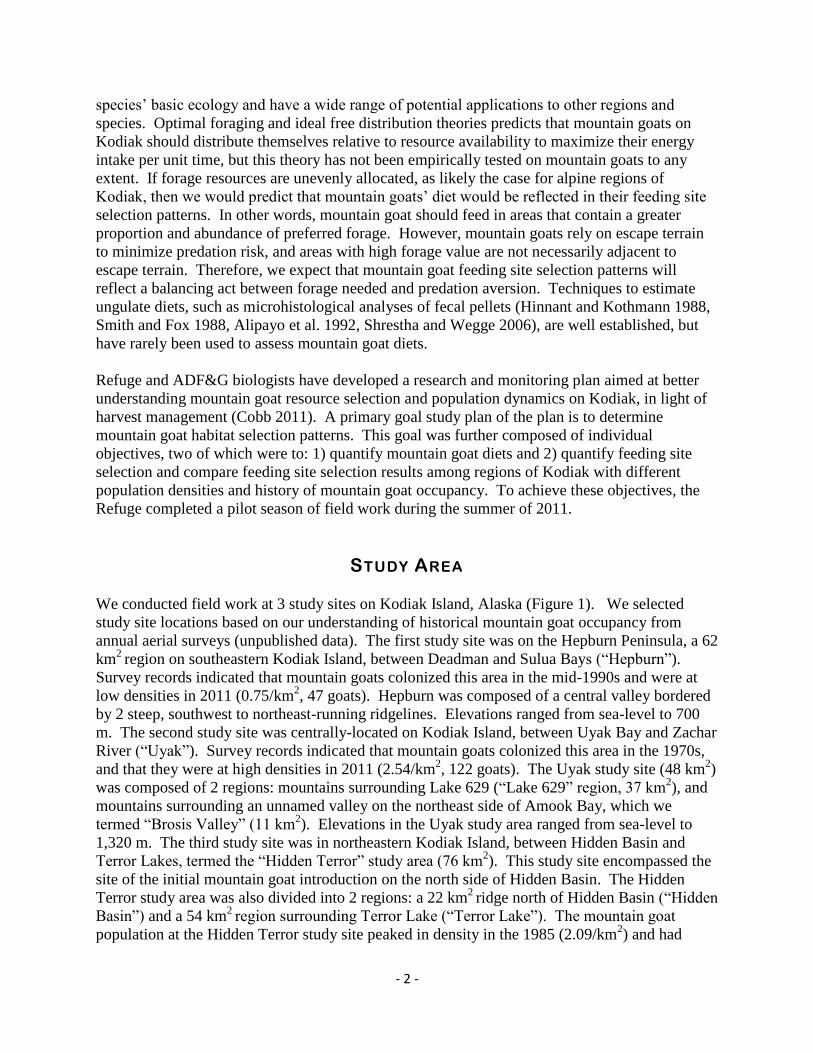
We conducted field work at 3 study sites on Kodiak Island, Alaska (Figure 1). We selected
study site locations based on our understanding of historical mountain goat occupancy from
annual aerial surveys (unpublished data). The first study site was on the Hepburn Peninsula, a 62
km2
region on southeastern Kodiak Island, between Deadman and Sulua Bays (“Hepburn”).
Survey records indicated that mountain goats colonized this area in the mid-1990s and were at
low densities in 2011 (0.75/km2, 47 goats). Hepburn was composed of a central valley bordered
by 2 steep, southwest to northeast-running ridgelines. Elevations ranged from sea-level to 700
m. The second study site was centrally-located on Kodiak Island, between Uyak Bay and Zachar
River (“Uyak”). Survey records indicated that mountain goats colonized this area in the 1970s,
and that they were at high densities in 2011 (2.54/km2, 122 goats). The Uyak study site (48 km
2)
was composed of 2 regions: mountains surrounding Lake 629 (“Lake 629” region, 37 km2), and
mountains surrounding an unnamed valley on the northeast side of Amook Bay, which we
termed “Brosis Valley” (11 km2). Elevations in the Uyak study area ranged from sea-level to
1,320 m. The third study site was in northeastern Kodiak Island, between Hidden Basin and
Terror Lakes, termed the “Hidden Terror” study area (76 km2). This study site encompassed the
site of the initial mountain goat introduction on the north side of Hidden Basin. The Hidden
Terror study area was also divided into 2 regions: a 22 km2
ridge north of Hidden Basin (“Hidden
Basin”) and a 54 km2
region surrounding Terror Lake (“Terror Lake”). The mountain goat
population at the Hidden Terror study site peaked in density in the 1985 (2.09/km2) and had

- 3 -
since declined to 1.21/km2 in 2011. Elevations in the Hidden Terror study site ranged from sea-
level to 1,130 m.
Habitat diversity was similar among study site, although habitat distributions and relative
abundances varied. Lower elevations (sea-level to 300 m) generally consisted of a matrix of
mixed forb meadow, open alder with forb meadow, and dense alder habitat types (Fleming and
Spencer 2007). The mixed forb meadow habitat consisted of lupine (Lupinus nootkatensis),
fireweed (Epilobium angustifolium), goldenrod (Solidago lepida), Jacob’s ladder (Polemonium
acutiflorum), paintbrush (Caltilleja unalaschcensis), and burnett (Sanguisorba stipulate). The
open alder with forb meadow habitat type consisted of patches of dense alder (Alnus crispa),
often mixed with salmonberry (Rubus spectabilis) and elderberry (Sambucus racemosa), and
patches of forbs such as fireweed, lupine, and cow parsnip (Heraculem lanatum). In general,
lower elevations in the Hepburn and Hidden Terror study sites were composed of more forbs and
less alder, but the opposite was true for the Uyak study site. Higher elevations were dominated
by alpine tundra, alpine forb meadow, alpine heath, prostrate shrub tundra, exposed bedrock,
talus slopes, and snow-covered habitat types (Fleming and Spencer 2007). Common plants
included long-awned sedge (Carex macrochaeta), mosses, lichens, partridgefoot (Luetkea
pectinata), and black crowberry (Empetrum nigrum). The Hepburn study site consisted of less
exposed bedrock and inaccessible cliffs than the other study sites. Snow was dominant at the
Hidden Terror study site during the early summer, common at the Uyak study site, and almost
absent from the Hepburn study site.
- 4 -
Figure 1. Mountain goat field research study sites, summer 2011, Kodiak Island, Alaska.
5
METHODS
We attempted to visit each study site twice: once in the early summer (June – early July) and
once in the late summer (late July – August). During visits, our goals were to: conduct
behavioral observations on mountain goats, collect fresh mountain goat fecal pellets, and to
conduct vegetation surveys at mountain goat feeding sites and random alpine locations. To do
this, we first located mountain goat groups by hiking to known mountain goat group locations
(determined by aerial surveys), scanning for mountain goats with binoculars, and traversing the
study areas looking for goats.
Diet
We quantified mountain goat diets at each study site using microhistological analyses of fecal
pellets (Hinnant and Kothmann 1988). To collect fecal pellet samples, we observed a mountain
goat group until we saw a goat defecate. We then slowly approached the center of the group’s
location, and searched for fresh fecal pellet samples. We classified pellets as fresh if they were
moist, soft, had a slimy shin, and were free of mold and insects. We collected approximately 25-
mg (15 pellets) of fresh pellets from individual piles into a Nasco WhirlPaks using a toothpick.
We did not collect pellets if there was any doubt that they were fresh. We kept fecal pellet
samples in a cool dry location while we were in the field, and then we froze samples upon
returning to Refuge headquarters. We submitted a random subsample from each study area to
the Wildlife Habitat Nutrition Lab at Washington State University (Pullman, WA) at the
conclusion of the field season (September).
Behavior
We attempted to quantify mountain goats behaviors when we first observed a mountain goat
group. To do this, we classified the behaviors (feeding, bedded, standing, walking, or running)
of all individuals in a group at 5-minute intervals, for 30 minutes, or until the group moved out of
view of the observers. In addition to classifying behaviors, we recorded the group’s size and
classified individuals into age/sex classes (adults, billies, nannies, and kids). We noted the
weather (sun, partly cloudy, cloudy, rain, snow, sleet, or fog). We recorded wind speed and
direction using a handheld weather station (Kestrel 2500, Birmingham, MI). We documented
whether any goats in the group were aware of our presence. If the group was aware of us, we
recorded the time that they first reacted, the distance between the closest mountain goat and us,
and the majority of the group’s behavioral response to our presence. We compared behaviors
and group classifications among study sites with Kruskall-Wallis chi-square tests (Zar 2009).
Feeding Site Selection
We defined feeding sites as the centroid location of a mountain goat group that was observed
feeding. To quantify feeding site selection, we compared habitats at feeding sites against random
sites. We defined the extent of available habitat as typical mountain goat summer range; which
including low willow, alpine tundra, heath, forb-graminoid meadows, snow/ice, and fragmented
rock habitat types (Hjeljord 1970, Von Elsner-Schack 1986, Fox et al. 1989, Poole and Heard
2003). We used the Kodiak Archipelago Land Cover Classification (KLCC) GIS layer to
delineate these regions within study sites (Fleming and Spencer 2007). Additionally, we limited
available habitats to areas over 152 m (500 ft) above sea level because lowland regions were
unlikely to include typical mountain goat summer range (Hjeljord 1973), and because including

6
these generally alder and willow-dominated habitats would require a survey effort beyond the
scope of this project. We designated random sites by creating 100 unique random waypoints in
available habitat, in each study site and for each visit, using Spatial Analyst in ArcGIS 9.3 (ESRI
2012). We included an inhibition distance (minimum allowable distance between random
waypoints) of 100-m, to eliminate potential overlap between transects and to insure a more even
distribution across the study site. We uploaded random waypoints into GPS units, which we
used to locate random waypoints in the field.
We surveyed vegetation at feeding sites and random sites. At feeding sites, we slowly
approached the centroid of a mountain goat group’s location. We recorded a GPS waypoint at
that location using a portable GPS unit (Garmin 60CSx), and we inserted an aluminum tent stake
(Coghlan’s, Winnipeg, Manitoba) into the ground. Our methods for conducting vegetation
surveys were the same at feeding sites and random waypoints. We selected a random compass
bearing, using a random number table, and extended a tape measure from the tent stake along the
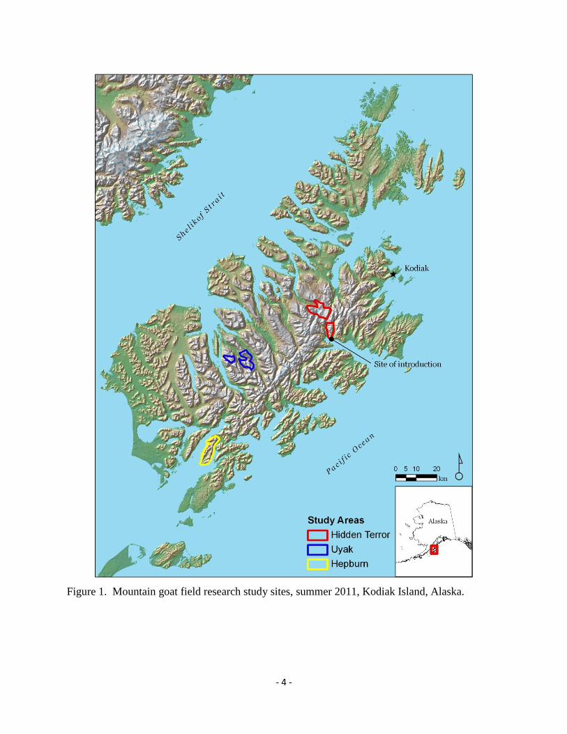
random bearing for 16-m in both directions. Starting from the tent stake, we placed a 50 x 20-cm
PVC plot to right side of the tape measure at 2-m intervals (Daubenmire 1959) (Figure 2). At
each interval, we first attempted to record all vascular plant species, or habitat classes (bare
ground, bare rock, litter, snow, water, and cliff) present at the point. We also recorded
nonvascular plants (mosses, fungus, and lichens), but we did not attempt to classify them by
species. We then recorded plants and habitat classes within each plot and classified percent
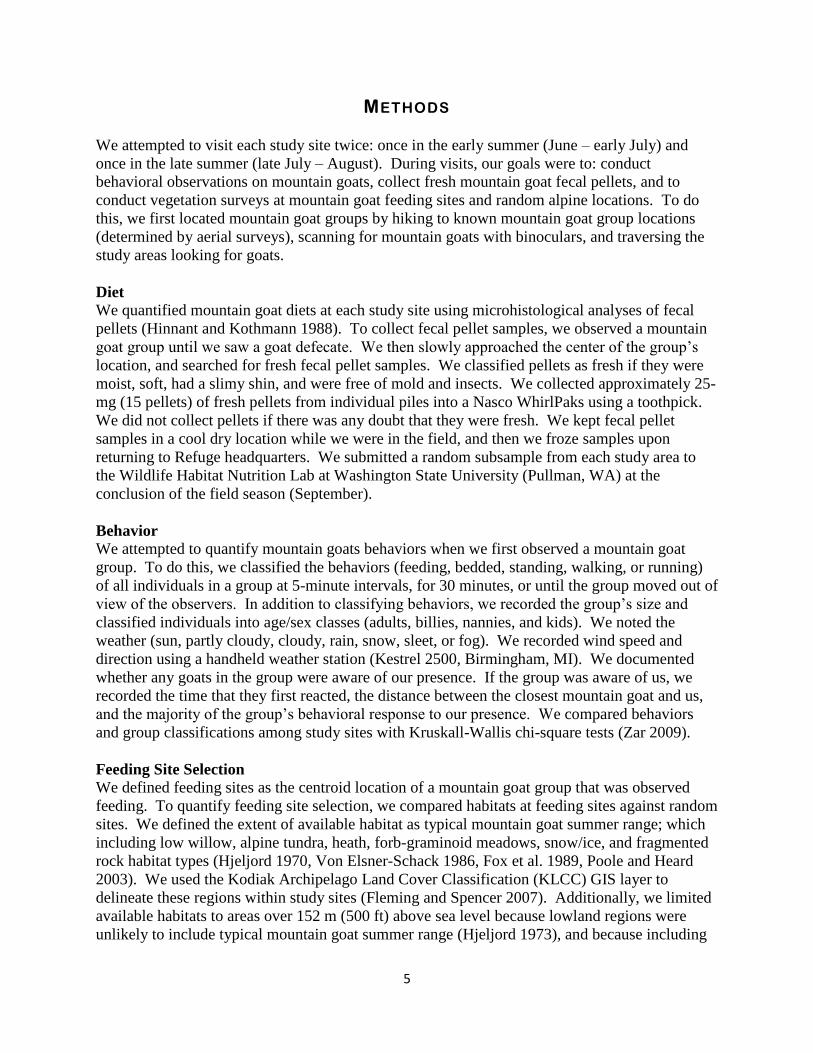
canopy cover. Percent canopy cover was defined the percent of the plot that encompasses the
sum of all imaginary polygons drawn on leaf tips of undisturbed canopies (ignoring
inflorescences), and projected onto the ground (Kent 2012) (Figure 3). We classified canopy
cover into 12 classes following a modified Domin cover scale (Currall 1987) and based on the
relative percentage canopy cover within the plot (Figure 4). We quantified canopy cover by
observing the plot from directly above and estimating percentage canopy cover for each plant
species as a single unit. For vascular plants that we could not classify to the species level, we
made attempts to classify to the genus level. Standing over the center waypoint, we took an
oblique photo of the transect line in both directions. During the second half of the field season,
we noted whether any mountain goat feces were observed within plots and whether plants in
plots had been grazed.
To summarize habitat types, we quantified the habitat biodiversity, percent frequency, and
percent cover at feeding and random sites. Biodiversity of a transect was defined as the sum of
all plant species and habitat classes within all plots along a single transect. The habitat percent
frequency of a transect was defined as the number of occurrences of a particular plant species or
habitat type (the number of plots in which it was observed within a transect), divided by the total
number of plots sampled along the transect (17), and then multiplied by 100. Habitat percent
cover for each transect was defined as the summed percent canopy cover of each plant species
within all plots on a particular transect divided by the total canopy cover of all plant species and
habitats within all plots on a that transect.
7
Figure 2. Vegetation survey transects and locations of Daubenmire plots used to quantify the
plant diversity and canopy cover at mountain goat feeding sites and random sites, Kodiak Island,
Alaska.
Figure 3. Canopy cover for an individual plant, as defined for mountain goat feeding site
selection.
8
a.
b.
% Cover Classes
Code Range Mid Code Range Mid T 0-1% 0.50% 5 45-55% 50% 0 1-5% 3% 6 55-65% 60% 1 5-15% 10% 7 65-75% 70% 2 15-25% 20% 8 75-85% 80% 3 25-35% 30% 9 85-95% 90% 4 35-45% 40% X 95-100% 97.5%
Figure 4. Daubenmire plot with a guide for quantifying percentage vegetation canopy cover (a)
and canopy cover classes with associated range of percent canopy covers (b) used to quantify
vegetation cover at mountain goat feeding sites and random available locations.
Since mountain goats are associated with steep terrain that they use to escape from predators, we
included a measure of escape terrain as a predictor of feeding site selection. Escape terrain has
been described as steep rocky slopes, ranging from >250 to >33
0 (Adams and Bailey 1982, Gross
et al. 2002). To be conservative, we defined escape terrain as slopes >33o. We quantified the
spatial distribution of escape terrain within study sites using a 30-m pixel Digital Elevation
Model (DEM) (ESRI 2012). We entered waypoints into a GIS and used ArcMap’s NEAR
function to calculate the distance from the center of each transect to the closest patch of escape
terrain.
Habitat selection of northern ungulates, such as mountain goats, is affected by forage availability
and thermodynamics, which is in turn influenced by relative solar radiation (Keating et al. 2007).
To determine if mountain goat feeding site selection at Kodiak was influence by solar radiation,
we first estimated hypothetical solar illumination (1 July, 12:00pm) across Kodiak using the
hillshade function applied to a DEM in ArcGIS (ESRI 2012). We then standardized hillshade
values for Kodiak between 0 and 1 by converting raw hillshade raster cell values to z-score
9
values (Zar 2009). Finally, we overlaid feeding and random site waypoints onto the standardized
hillshade raster layer to determine a relative hillshade at each waypoint.
We considered transects as the sampling unit for statistical analyses. Because the large number
of plant species and habitats that we classified would have produced too many predictors in our
candidate models, we first selected the 10 most commonly observed habitat types, and the 3
additional computed habitat predictors (habitat diversity, distance to escape terrain, and
hillshade), to include in candidate feeding site selection models. The top-10 habitats accounted
for approximately 33% of all observations. To avoid issues associated with correlation among
habitat percent frequency and percent cover, we ran separate pools of candidate logistic
regression models for each. Both pools of candidate models included diversity, distance to
escape terrain, and hillshade. For each pool of candidate predictors, we computed a Pearson
product-moment correlation matrix to assess relative correlation among predictors. For paired of
predictors that were highly correlated (>.30) (Zar 2009), we retained the predictor that was most
ecologically relevant. To evaluate competing candidate models, we examined differences in
Akaike Information Criterion values corrected for small samples sizes (ΔAICc) using a
backwards, step-wise approach (Burnham and Anderson 2002). Models with ΔAICc greater than
2 were considered to have better predictive ability. Finally, we calculated AICc weights (w) to
determine relative support for each of the top models.
RESULTS
We visited each study area twice, between 2 June and 19 August, 2011 (Table 1). Each visit
averaged 8 days in duration (range = 4-10 days). Four researchers visited each study site, but to
maximize efficiency, we split into 2 groups each day to survey separate regions within the study
site.
Table 1. Dates and durations (in days) of study site visits for mountain goat research, summer
2011, Kodiak, Alaska.
Trip 1__ __ Trip 2__ __
Study Area Dates Duration (days) Dates Duration (days)
Hepburn 6/2-6/8 7 7/13-7/21 9
Uyak 6/14-6/17 4 7/29-8/7* 10
Hidden Terror 6/22-7/1** 10 8/12-8/21** 10 *includes Lake 629 and Brosis Valley subregions
**includes Terror Lake and Hidden Basin subregions
10
Diet
We collected 200 mountain goat pellet samples (Table 2). From these, we sub-sampled 59 pellet
samples to be microscopically analyzed for plant composition. We submitted 10 pellet samples
per study area per visit, except for the first Hepburn visit for which we were only able to collect
9 samples because of foul weather (n = 59). Microhistological lab results will be available
March 2012.
Table 2. Number of fecal pellet samples collected in each study site and subregion during
summer 2011 mountain goat field season, Kodiak Island, Alaska.
Study Area Subregion Visit 1 Visit 2 Total
Hepburn n/a 11 27 38
Uyak 629 9 34 43
Uyak Brosis Valley 0 22 22
Terror/Hidden Terror Lake 13 39 52
Terror/Hidden Hidden Basin 15 30 45
TOTAL 48 152 200
Behavior
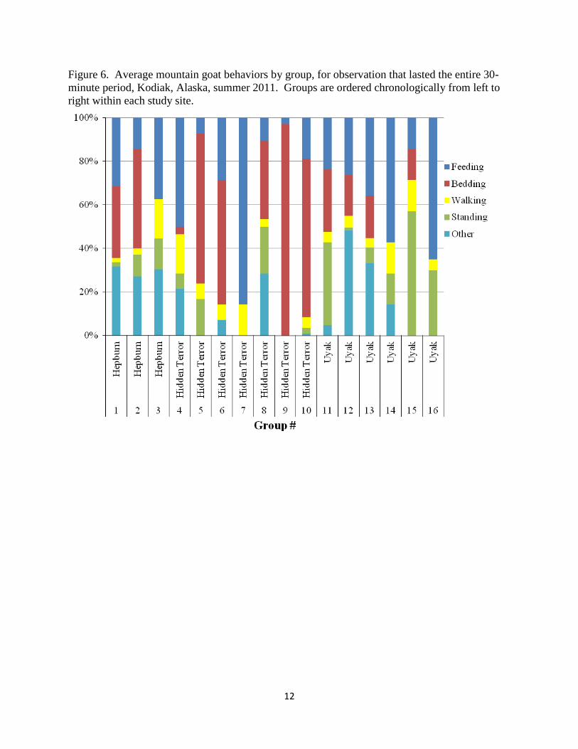
We conducted behavioral observations on 28 mountain goat groups. Mountain goats became
aware of the observers during 9 (32%) attempts at an average distance of 527. 63 m (SE =
61.07). We were able to complete 16 (57%) full 30-minute behavioral observations (3 at
Hepburn, 6 at Uyak, and 7 at Hidden Terror), without mountain goat groups moving out of view.
Group sizes averaged 9 mountain goats (SE = 1.76), of which 8 (SE = 1.38) were adults and 1
(SE = 0.31) was a kid (Figure 5). We were unable to classify 13 (48%) groups by sex because of
far distance between the groups and the observers, and because inclement weather (fog, low
clouds, or heavy rain). Groups that we were able to classify by sex were on average composed
of 69% nannies, 23% kids, and 8% billies. Group sizes did not differ among study sites (KW x2
= 0.19, p = 0.91).
11
Figure 5. Box plot of mountain goat group sizes classified during behavioral observations,
Kodiak Island, Alaska, summer 2011. Bold lines indicate medians, and boxes extend to the 1st
and 3rd
quartiles, and the circle indicates an outlier.
12
Figure 6. Average mountain goat behaviors by group, for observation that lasted the entire 30-
minute period, Kodiak, Alaska, summer 2011. Groups are ordered chronologically from left to
right within each study site.
13
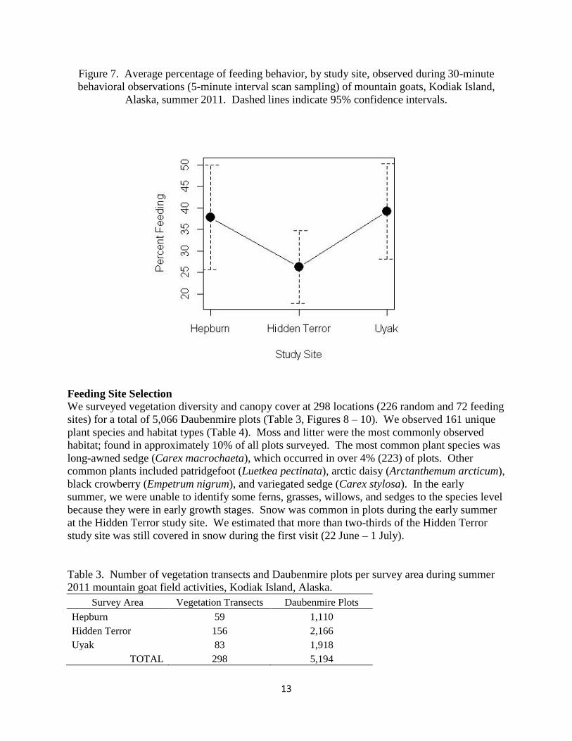
Figure 7. Average percentage of feeding behavior, by study site, observed during 30-minute
behavioral observations (5-minute interval scan sampling) of mountain goats, Kodiak Island,
Alaska, summer 2011. Dashed lines indicate 95% confidence intervals.
Feeding Site Selection
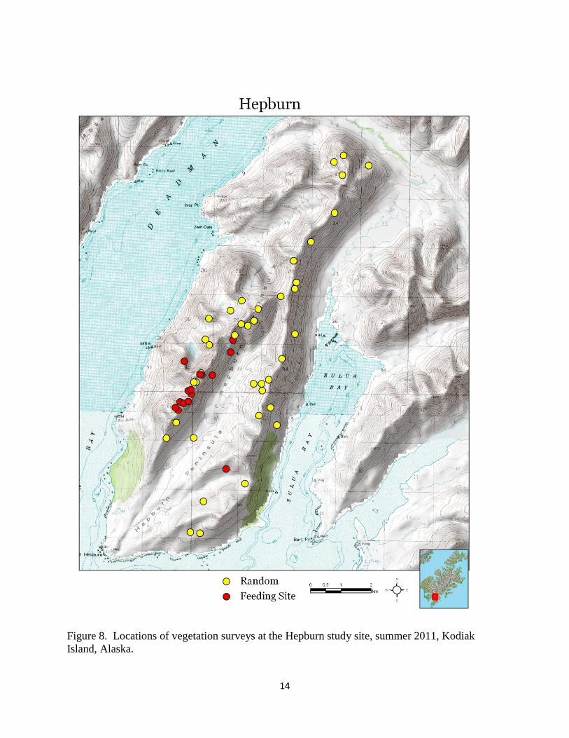
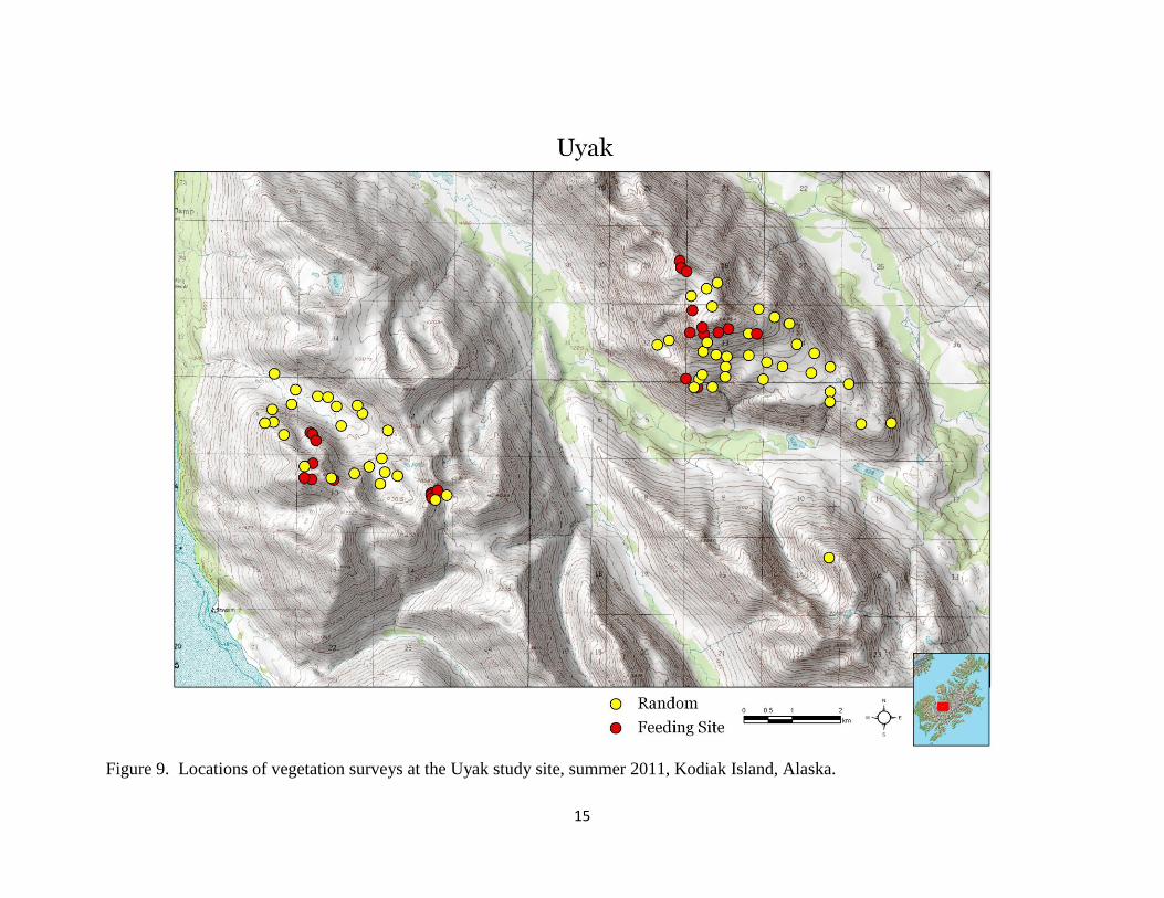
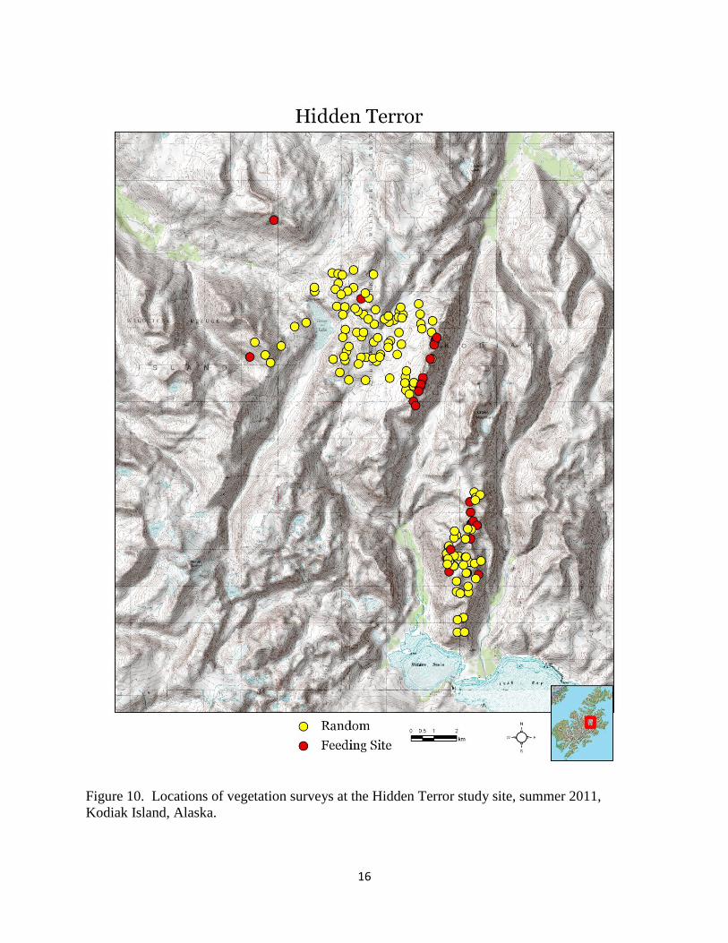
We surveyed vegetation diversity and canopy cover at 298 locations (226 random and 72 feeding
sites) for a total of 5,066 Daubenmire plots (Table 3, Figures 8 – 10). We observed 161 unique
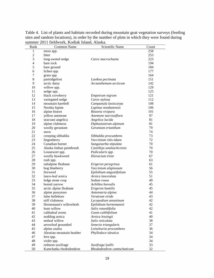
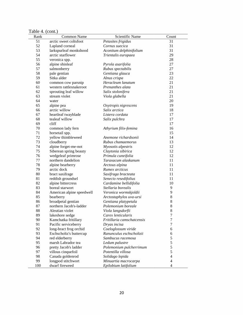
plant species and habitat types (Table 4). Moss and litter were the most commonly observed
habitat; found in approximately 10% of all plots surveyed. The most common plant species was
long-awned sedge (Carex macrochaeta), which occurred in over 4% (223) of plots. Other
common plants included patridgefoot (Luetkea pectinata), arctic daisy (Arctanthemum arcticum),
black crowberry (Empetrum nigrum), and variegated sedge (Carex stylosa). In the early
summer, we were unable to identify some ferns, grasses, willows, and sedges to the species level
because they were in early growth stages. Snow was common in plots during the early summer
at the Hidden Terror study site. We estimated that more than two-thirds of the Hidden Terror
study site was still covered in snow during the first visit (22 June – 1 July).
Table 3. Number of vegetation transects and Daubenmire plots per survey area during summer
2011 mountain goat field activities, Kodiak Island, Alaska.
Survey Area Vegetation Transects Daubenmire Plots
Hepburn 59 1,110
Hidden Terror 156 2,166
Uyak 83 1,918
TOTAL 298 5,194
14
Figure 8. Locations of vegetation surveys at the Hepburn study site, summer 2011, Kodiak
Island, Alaska.
15
Figure 9. Locations of vegetation surveys at the Uyak study site, summer 2011, Kodiak Island, Alaska.
16
Figure 10. Locations of vegetation surveys at the Hidden Terror study site, summer 2011,
Kodiak Island, Alaska.
17
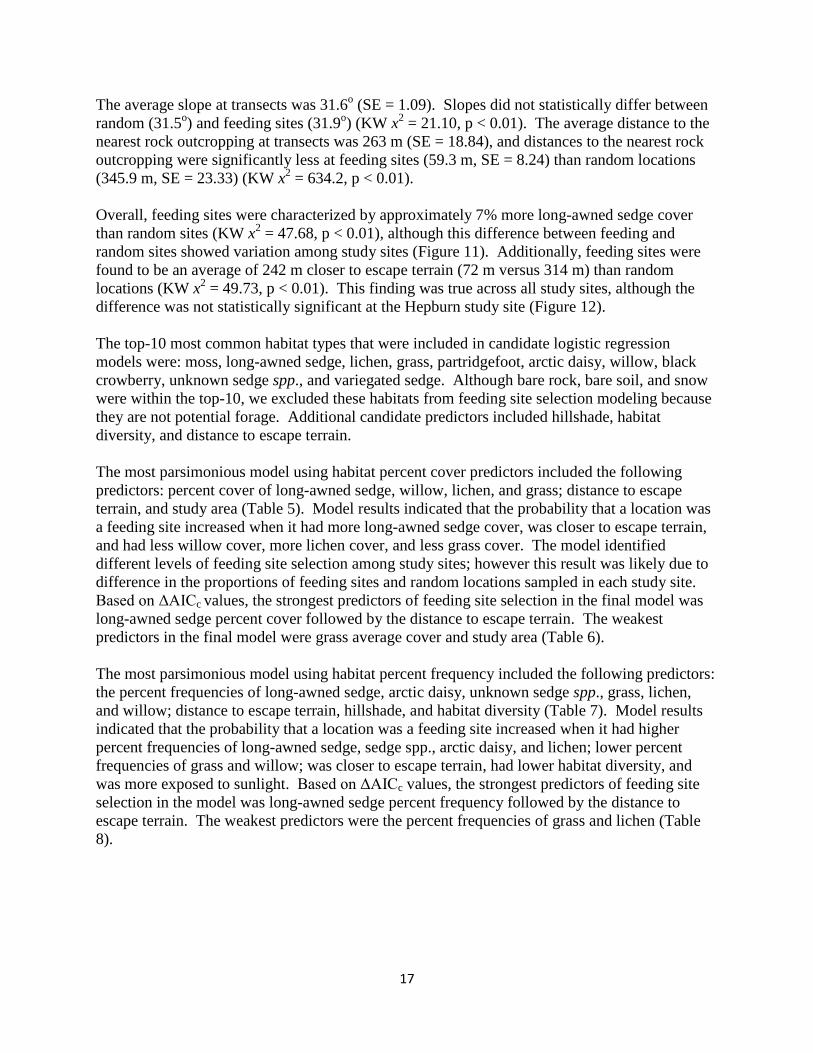
The average slope at transects was 31.6o (SE = 1.09). Slopes did not statistically differ between
random (31.5o) and feeding sites (31.9
o) (KW x
2 = 21.10, p < 0.01). The average distance to the
nearest rock outcropping at transects was 263 m (SE = 18.84), and distances to the nearest rock
outcropping were significantly less at feeding sites (59.3 m, SE = 8.24) than random locations
(345.9 m, SE = 23.33) (KW x2 = 634.2, p < 0.01).
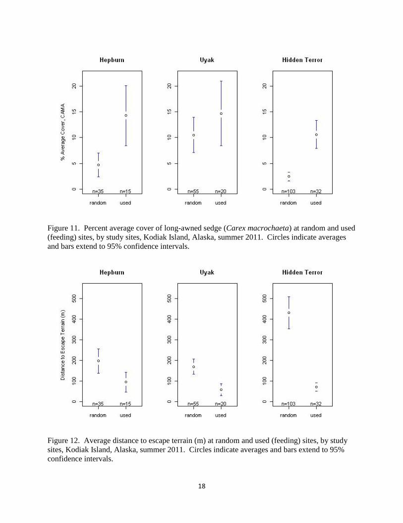
Overall, feeding sites were characterized by approximately 7% more long-awned sedge cover
than random sites (KW x2 = 47.68, p < 0.01), although this difference between feeding and
random sites showed variation among study sites (Figure 11). Additionally, feeding sites were
found to be an average of 242 m closer to escape terrain (72 m versus 314 m) than random
locations (KW x2 = 49.73, p < 0.01). This finding was true across all study sites, although the
difference was not statistically significant at the Hepburn study site (Figure 12).
The top-10 most common habitat types that were included in candidate logistic regression
models were: moss, long-awned sedge, lichen, grass, partridgefoot, arctic daisy, willow, black
crowberry, unknown sedge spp., and variegated sedge. Although bare rock, bare soil, and snow
were within the top-10, we excluded these habitats from feeding site selection modeling because
they are not potential forage. Additional candidate predictors included hillshade, habitat
diversity, and distance to escape terrain.
The most parsimonious model using habitat percent cover predictors included the following
predictors: percent cover of long-awned sedge, willow, lichen, and grass; distance to escape
terrain, and study area (Table 5). Model results indicated that the probability that a location was
a feeding site increased when it had more long-awned sedge cover, was closer to escape terrain,
and had less willow cover, more lichen cover, and less grass cover. The model identified
different levels of feeding site selection among study sites; however this result was likely due to
difference in the proportions of feeding sites and random locations sampled in each study site.
Based on ΔAICc values, the strongest predictors of feeding site selection in the final model was
long-awned sedge percent cover followed by the distance to escape terrain. The weakest
predictors in the final model were grass average cover and study area (Table 6).
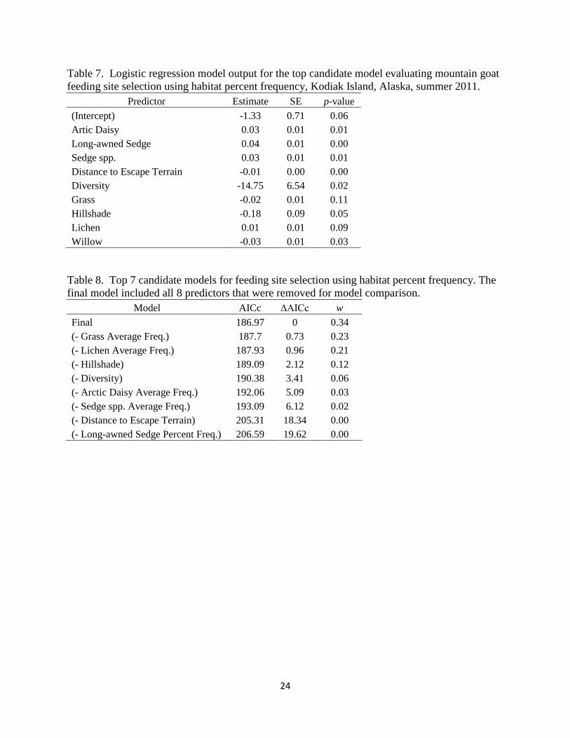
The most parsimonious model using habitat percent frequency included the following predictors:
the percent frequencies of long-awned sedge, arctic daisy, unknown sedge spp., grass, lichen,
and willow; distance to escape terrain, hillshade, and habitat diversity (Table 7). Model results
indicated that the probability that a location was a feeding site increased when it had higher
percent frequencies of long-awned sedge, sedge spp., arctic daisy, and lichen; lower percent
frequencies of grass and willow; was closer to escape terrain, had lower habitat diversity, and
was more exposed to sunlight. Based on ΔAICc values, the strongest predictors of feeding site
selection in the model was long-awned sedge percent frequency followed by the distance to
escape terrain. The weakest predictors were the percent frequencies of grass and lichen (Table
8).
18
Figure 11. Percent average cover of long-awned sedge (Carex macrochaeta) at random and used
(feeding) sites, by study sites, Kodiak Island, Alaska, summer 2011. Circles indicate averages
and bars extend to 95% confidence intervals.
Figure 12. Average distance to escape terrain (m) at random and used (feeding) sites, by study
sites, Kodiak Island, Alaska, summer 2011. Circles indicate averages and bars extend to 95%
confidence intervals.
19
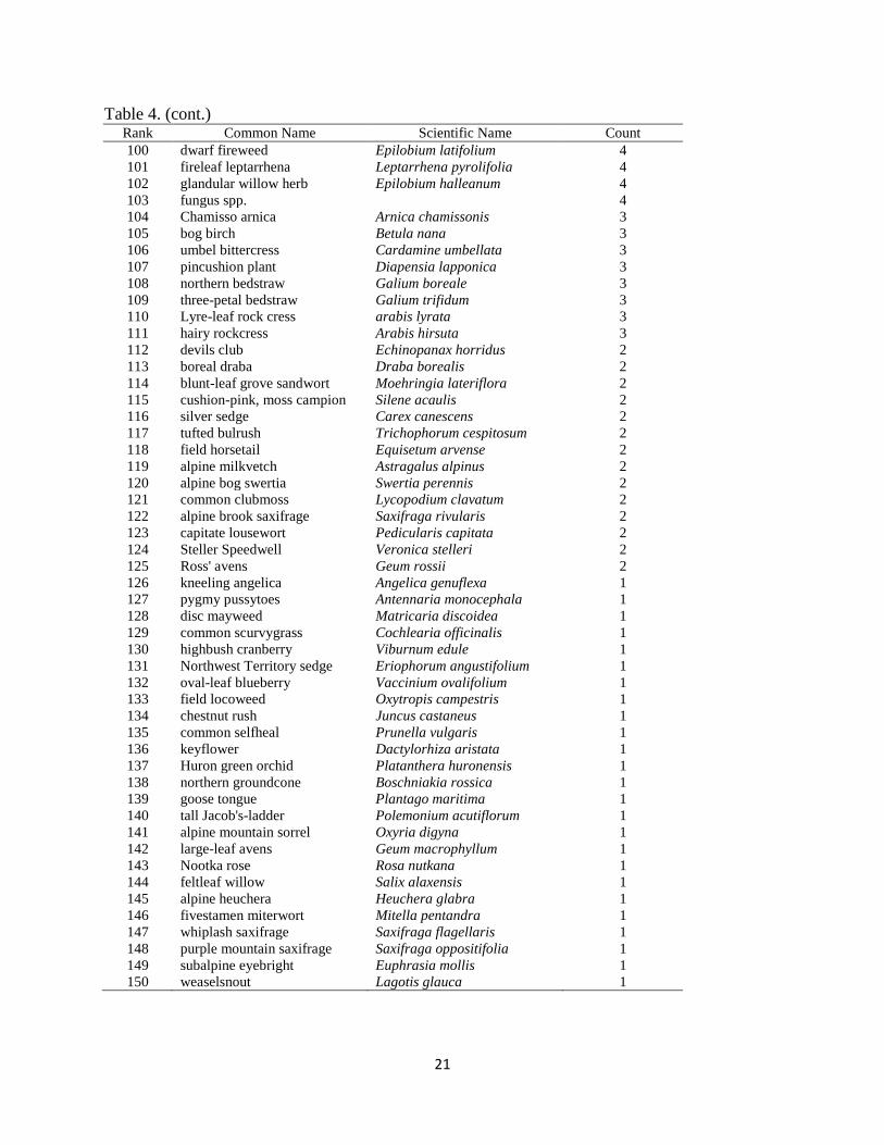
Table 4. List of plants and habitats recorded during mountain goat vegetation surveys (feeding
sites and random locations), in order by the number of plots in which they were found during
summer 2011 fieldwork, Kodiak Island, Alaska. Rank Common Name Scientific Name Count
1 moss spp.
258
2 litter
253
3 long-awned sedge Carex macrochaeta 223
4 bare rock
194
5 bare ground
184
6 lichen spp.
177
7 grass spp.
164
8 partridgefoot Luetkea pectinata 151
9 arctic daisy Arctanthemum arcticum 142
10 willow spp.
129
11 sedge spp.
125
12 black crowberry Empetrum nigrum 121
13 variegated sedge Carex stylosa 112
14 mountain harebell Campanula lasiocarpa 108
15 Nootka lupine Lupinus nootkatensis 106
16 alpine bistort Bistorta vivipara 101
17 yellow anemone Anemone narcissiflora 97
18 seacoast angelica Angelica lucida 81
19 alpine clubmoss Diphasiastrum alpinum 81
20 woolly geranium Geranium erianthum 79
21 snow
74
22 creeping sibbaldia Sibbaldia procumbens 73
23 lingonberry Vaccinium vitis-idaea 72
24 Canadian burnet Sanguisorba stipulata 70
25 Alaska Indian paintbrush Castilleja unalaschcensis 70
26 Lousewort spp. Pedicularis spp. 70
27 woolly hawkweed Hieracium triste 67
28 rush spp.
63
29 subalpine fleabane Erigeron peregrinus 61
30 bog blueberry Vaccinium uliginosum 56
31 fireweed Epilobium angustifolium 55
32 lance-leaf arnica Arnica lanceolata 51
33 ledge stone crop Sedum rosea 49
34 boreal yarrow Achillea borealis 45
35 arctic alpine fleabane Erigeron humilis 45
36 alpine pussytoes Antennaria alpina 44
37 false hellebore Veratrum viride 43
38 stiff clubmoss Lycopodium annotinum 42
39 Hornemann's willowherb Epilobium hornemannii 42
40 least willow Salix rotundifolia 42
41 calthaleaf avens Geum calthifolium 41
42 nodding arnica Arnica lessingii 40
43 netleaf willow Salix reticulata 38
44 arrowleaf groundsel Senecio triangularis 37
45 alpine azalea Loiseleuria procumbens 36
46 Aleutian mountain heather Phyllodoce aleutica 34
47 fern spp.
34
48 violet spp.
34
49 redstem saxifrage Saxifraga lyallii 33
50 Kamchatka rhododendron Rhododendron camtschaticum 32
20
Table 4. (cont.) Rank Common Name Scientific Name Count
51 arctic sweet coltsfoot Petasites frigidus 31
52 Lapland corneal Cornus suecica 31
53 larkspurleaf monkshood Aconitum delphinifolium 31
54 arctic starflower Trientalis europaea 29
55 veronica spp.
28
56 alpine shinleaf Pyrola asarifolia 27
57 salmonberry Rubus spectabilis 27
58 pale gentian Gentiana glauca 23
59 Sitka alder Alnus crispa 22
60 common cow parsnip Heracleum lanatum 21
61 western rattlesnakeroot Prenanthes alata 21
62 sprouting leaf willow Salix stolonifera 21
63 stream violet Viola glabella 21
64 water
20
65 alpine pea Oxytropis nigrescens 19
66 arctic willow Salix arctica 18
67 heartleaf twayblade Listera cordata 17
68 tealeaf willow Salix pulchra 17
69 cliff
17
70 common lady fern Athyrium filix-femina 16
71 horsetail spp.
15
72 yellow thimbleweed Anemone richardsonii 14
73 cloudberry Rubus chamaemorus 13
74 alpine forget-me-not Myosotis alpestris 12
75 Siberean spring beauty Claytonia sibirica 12
76 wedgeleaf primrose Primula cuneifolia 12
77 northern dandelion Taraxacum alaskanum 11
78 alpine bearberry Arctous alpina 11
79 arctic dock Rumex arcticus 11
80 bract saxifrage Saxifraga bracteata 11
81 reddish groundsel Senecio resedifolius 11
82 alpine bittercress Cardamine bellidifolia 10
83 boreal starwort Stellaria borealis 9
84 American alpine speedwell Veronica wormskjoldii 9
85 bearberry Arctostaphylos uva-ursi 8
86 broadpetal gentian Gentiana platypetala 8
87 northern Jacob's-ladder Polemonium boreale 8
88 Aleutian violet Viola langsdorfii 8
89 lakeshore sedge Carex lenticularis 7
90 Kamchatka fritillary Fritillaria camschatcensis 7
91 Pacific serviceberry Dryas incisa 7
92 long-bract frog orchid Coeloglossum viride 6
93 Eschscholtz's buttercup Ranunculus eschscholtzii 6
94 red elderberry Sambucus racemosa 5
95 marsh Labrador tea Ledum palustre 5
96 pretty Jacob's ladder Polemonium pulcherrimum 5
97 villous cinquefoil Potentilla villosa 5
98 Canada goldenrod Solidago lepida 4
99 longpod stitchwort Minuartia macrocarpa 4
100 dwarf fireweed Epilobium latifolium 4
21
Table 4. (cont.) Rank Common Name Scientific Name Count
100 dwarf fireweed Epilobium latifolium 4
101 fireleaf leptarrhena Leptarrhena pyrolifolia 4
102 glandular willow herb Epilobium halleanum 4
103 fungus spp.
4
104 Chamisso arnica Arnica chamissonis 3
105 bog birch Betula nana 3
106 umbel bittercress Cardamine umbellata 3
107 pincushion plant Diapensia lapponica 3
108 northern bedstraw Galium boreale 3
109 three-petal bedstraw Galium trifidum 3
110 Lyre-leaf rock cress arabis lyrata 3
111 hairy rockcress Arabis hirsuta 3
112 devils club Echinopanax horridus 2
113 boreal draba Draba borealis 2
114 blunt-leaf grove sandwort Moehringia lateriflora 2
115 cushion-pink, moss campion Silene acaulis 2
116 silver sedge Carex canescens 2
117 tufted bulrush Trichophorum cespitosum 2
118 field horsetail Equisetum arvense 2
119 alpine milkvetch Astragalus alpinus 2
120 alpine bog swertia Swertia perennis 2
121 common clubmoss Lycopodium clavatum 2
122 alpine brook saxifrage Saxifraga rivularis 2
123 capitate lousewort Pedicularis capitata 2
124 Steller Speedwell Veronica stelleri 2
125 Ross' avens Geum rossii 2
126 kneeling angelica Angelica genuflexa 1
127 pygmy pussytoes Antennaria monocephala 1
128 disc mayweed Matricaria discoidea 1
129 common scurvygrass Cochlearia officinalis 1
130 highbush cranberry Viburnum edule 1
131 Northwest Territory sedge Eriophorum angustifolium 1
132 oval-leaf blueberry Vaccinium ovalifolium 1
133 field locoweed Oxytropis campestris 1
134 chestnut rush Juncus castaneus 1
135 common selfheal Prunella vulgaris 1
136 keyflower Dactylorhiza aristata 1
137 Huron green orchid Platanthera huronensis 1
138 northern groundcone Boschniakia rossica 1
139 goose tongue Plantago maritima 1
140 tall Jacob's-ladder Polemonium acutiflorum 1
141 alpine mountain sorrel Oxyria digyna 1
142 large-leaf avens Geum macrophyllum 1
143 Nootka rose Rosa nutkana 1
144 feltleaf willow Salix alaxensis 1
145 alpine heuchera Heuchera glabra 1
146 fivestamen miterwort Mitella pentandra 1
147 whiplash saxifrage Saxifraga flagellaris 1
148 purple mountain saxifrage Saxifraga oppositifolia 1
149 subalpine eyebright Euphrasia mollis 1
150 weaselsnout Lagotis glauca 1

22
Table 4. (cont.) Rank Common Name Scientific Name Count
151 Oeder's lousewort Pedicularis oederi 1
152 whorled lousewort Pedicularis verticillata 1
153 little yellow-rattle Rhinanthus minor 1
154 dwarf marsh violet Viola epipsila 1
155 Sitka spruce Picea sitchensis 1
156 mountain wood fern Dryopteris campyloptera 1
157 Alaska spirea Spiraea beayverdiana 1
158 long-stalked starwort Stellaria longipes 1
159 poison water hemlock Conium maculatum 1
160 stinging nettle Urtica doica 1
161 wooly lousewort Pedicularis kanei 1

23
Table 5. Logistic regression model output for the top candidate model evaluating mountain goat
feeding site selection using percent habitat cover, Kodiak Island, Alaska, summer 2011.
Predictor Estimate SE p-value
(Intercept) -0.54 0.49 0.27
Long-awned Sedge Average Cover 0.11 0.02 <0.01
Distance to Escape Terrain -0.01 0.00 <0.01
Grass Average Cover -0.11 0.06 0.06
Lichen Average Cover 0.07 0.03 0.01
Willow Average Cover -0.23 0.09 0.01
Hidden Terror Study Site 0.44 0.47 0.34
Uyak Study Site -0.90 0.55 0.10
Table 6. Top 7 candidate models for feeding site selection using habitat percent cover. The final
model included all 6 predictors that were removed for model comparison.
Model AICc ∆AICc w
Final Model 195.84 0 0.66
(- Grass Average Cover) 198.59 2.75 0.17
(- Study Area) 198.83 2.99 0.15
(- Lichen Average Cover) 202.65 6.81 0.02
(- Salix Average Cover) 204.52 8.68 0.01
(- Distance to Escape Terrain) 226.28 30.44 0.00
(- Long-awned Sedge Average Cover) 231.47 35.63 0.00
24
Table 7. Logistic regression model output for the top candidate model evaluating mountain goat
feeding site selection using habitat percent frequency, Kodiak Island, Alaska, summer 2011.
Predictor Estimate SE p-value
(Intercept) -1.33 0.71 0.06
Artic Daisy 0.03 0.01 0.01
Long-awned Sedge 0.04 0.01 0.00
Sedge spp. 0.03 0.01 0.01
Distance to Escape Terrain -0.01 0.00 0.00
Diversity -14.75 6.54 0.02
Grass -0.02 0.01 0.11
Hillshade -0.18 0.09 0.05
Lichen 0.01 0.01 0.09
Willow -0.03 0.01 0.03
Table 8. Top 7 candidate models for feeding site selection using habitat percent frequency. The
final model included all 8 predictors that were removed for model comparison.
Model AICc ∆AICc w
Final 186.97 0 0.34
(- Grass Average Freq.) 187.7 0.73 0.23
(- Lichen Average Freq.) 187.93 0.96 0.21
(- Hillshade) 189.09 2.12 0.12
(- Diversity) 190.38 3.41 0.06
(- Arctic Daisy Average Freq.) 192.06 5.09 0.03
(- Sedge spp. Average Freq.) 193.09 6.12 0.02
(- Distance to Escape Terrain) 205.31 18.34 0.00
(- Long-awned Sedge Percent Freq.) 206.59 19.62 0.00
25
DISCUSSION
Our behavioral observation data suggest that mountain goats on Kodiak spent most days feeding
or bedded within feeding sites, as expected. We rarely observed mountain goat groups moving
among feeding sites. Observations in the field showed that mountain goats generally walked
short distances (a few meters) to new foraging patches within a feeding site, but this walking
behavior was likely under-represented in the data using our scan-sampling method because the
behavior was erratic, and each bout was short in duration. Although little information is
available on mountain goat behavior (but see Festa-Bianchet and Cote 2008), studies of other
northern ungulate behaviors have revealed results similar to ours (Frair et al. 2005). Large
herbivore spatial behavior has been characterized by short and localized movements within a
feeding site, separated by longer and more linear forays to new feeding sites (Forester et al.
2007). Our observations anecdotally support this pattern for mountain goats on Kodiak,
although more data is needed to statistically confirm it. Mountain goat behaviors on Kodiak are
likely adapted for conserving energy within a heterogeneous environment, while avoiding
predation. If preferred forage resources are unequally distributed and selected, as our feeding
site selection results suggest, mountain goats would benefit energetically by remaining at a
feeding site until the available forage reaches a critically low threshold and triggers a movement
to a new feeding site, or a threat immerges. When we inadvertently caused mountain goat
groups to flee feeding sites, we commonly observed what appeared to be the same individuals
(similar group sizes and classifications) reoccupy the same area shortly thereafter (i.e. the next
day).
Although we were unable to classify a large portion of mountain goat groups by sex, groups that
we could classify were generally composed of a large proportion of adult females, some kids,
and few adult males. Sexual segregation during the post-partuation to pre-rut season (typically
June to September) is common for mountain goats (“nursery bands”) (Festa-Bianchet and Cote
2008), and other northern herding ungulates such as bighorn sheep (Woolf et al. 1970), elk
(Weckerly 1998), and caribou (Jakimchuk et al. 1987). It is likely that the few adult males that
we observed were yearlings subsequently left the nursery bands to join other males following the
rut. Billies are typically solitary, or form small groups during the summer (Festa-Bianchet and
Cote 2008). Therefore, they might have been less likely to have been observed in this study and
underrepresented in our results.
Feeding site selection model results indicated that the percent cover and frequency of long-
awned sedge (Carex macrochaeta) were important predictors of summer feeding site selection
by mountain goats on Kodiak. Like many ungulates, mountain goats are considered selective
generalist feeders and display preferences for specific forage (Festa-Bianchet and Cote 2008).
This selective feeding behavior generally manifests itself in differential selection of available
habitats, which is likely what we observed on Kodiak. Mountain goat foraging sites have been
generally described as alpine meadows near cliffs (Von Elsner-Schack 1986). Confirming our
findings, mountain goats in the Hidden Basin region of Kodiak in the 1970s were found to select
sedge meadows and slopes as feeding sites during the summer, where their preferred forage was
also long-awned sedge (Hjeljord 1971). Microhistological results of mountain goat pellets
collected at feeding sites will confirm whether long-awned sedge is currently an important diet
item.
26
In addition to long-awned sedge’s importance to mountain goats on Kodiak, long-awned sedge
has also been found to be heavily used by Kodiak bears in the spring (Atwell et al. 1980). Given
overlapping dietary preferences, the potential exists for forage competition between bears and
mountain goats. Bears have been observed congregating at high densities (0.85 / km2) on
localized patches of long-awned sedge, and Atwell et al. proposed that bears focus on this plant
because it is fast growing, nutritious, and one of the first to emerge following snowmelt but
before salmon spawning (Atwell et al. 1980). Although the potential for competition exists, we
did not directly observe interactions between bears and mountain goats to support this
hypothesis.
Our model results indicate that escape terrain proximity is a critical element of mountain goat
feeding site selection. The importance of escape terrain to mountain goat habitat selection has
been well-documented (Gross et al. 2002, Poole and Heard 2003, Hamel and Cote 2007). Our
results are not surprising because capturing nutrients and avoiding predation are two of the most
fundamental elements to an animal’s behavior. Unlike other mountain goat populations that are
preyed upon by wolves (Fox and Streveler 1986), the only large predators capable of killing an
adult mountain goat on Kodiak are bear and humans (Cote and Beaudoin 1997, Demarchi et al.
2000). The level of bear predation on mountain goats on Kodiak is unknown, but bears are
known to predate mountain goats and their kids (Cote and Beaudoin 1997).
Field work on Kodiak’s mountain goats presented substantial logistic difficulties. Foul weather
often delayed flights transporting field crews, prevented aerial surveys, and made camping and
traveling in the field challenging. Researchers experienced high winds (40-50 mph) and rain
while camped on the eastern ridge of the Hepburn study area during the first night of field work
that damaged tents and nearly threw a food tent off the mountain. After this experience, we
camped in lower elevation valleys that were more protected from the winds and slept more
comfortably. Although we slept better, camping lower in elevation required longer and steeper
hikes (ascends exceeding 2000+ft daily), and long days (often 10-14 hours) to complete the field
work. When snows melted in the mountains and the weather was more amiable (mid-July to
August), the field crew was able to comfortably camp in the high country, and conserve time and
energy.
Our ability to locate and approach mountain goat groups depended on the study site, time of
year, and weather conditions. Goats at the Hepburn study site were easiest to locate and
approach because were relatively close to camp, not on inaccessible terrain (Hepburn is the
lowest elevation study site), and were found in the only 2 areas. Alternatively, locating and
approaching mountain goats in the Uyak and Terror Lake study sites presented more of a
challenge because they were further from our camps, on steeper or inaccessible terrain (steep
snow field and cliffs). In general, mountain goats were easier to locate and approach as the
summer progressed. This was mainly because they were generally found on ridges rather than
steeper mid-elevation slopes, and getting to their locations was easier because we were often
camped higher in elevation, and we were not required to post-hole over snow. Finally, mountain
goats were difficult-to-impossible to locate when weather conditions deteriorated. Low cloud
cover prevented us from be able to spot mountain goats from any distance, and we experienced
winds on ridges that made even standing and walking difficult. We found that mountain goats
27
were especially vigilant during high winds, which compounded the challenges associated with
approaching them. Taken together, these observations should have implications for future work.
Unless there is a direct need, researchers may want to consider delaying field work until mid-late
June when conditions are more hospitable and extending field work into September. We ended
field work before hunting season began (end of August) in response to concerns that our work
may impact hunters’ experience. Future field work might require trips longer than 10-day to
achieve study goals. Longer trip would allow for rest days and would buffer for potential
weather.
Understanding the diets, feeding site selection patterns and behaviors of the irrupting Kodiak
mountain goat population is a critical first step to empirically-driven harvest management.
Although just a pilot study, our results indicate that mountain goats select feeding sites that have
a greater proportion and abundance of sedge species, specifically long-awned sedge, and sites
that are close to escape terrain. This finding was universal, regardless of goat population
densities or history of occupancy. Pending fecal microhistological results will provide additional
information on their diets. If Kodiak’s mountain goat population exceeds their carrying capacity
on Refuge lands, which will occur unless the current population growth rate is limited by hunting
or other means, goats will likely cause a reduction in their preferred forage species, which could
in turn affect other species, such as bears, that also rely on these species. Future work is needed
to further understand the relationship between goats and Kodiak’s mountain goat resource
selection patterns, population dynamics, and harvest management options.
ACKNOWLEDGEMENTS
This study would not have been possible without the hard work and dedication of many people.
We cannot say enough about the commitment and enthusiasm of 2011 mountain goat field
volunteers: Ross Dorendorf, Adia Sovie, Aarin Sengsirirak, Meg Inokuma, and Tim Melham.
Thanks to Refuge pilots Kevin Van Hatten and Isaac Bedingfield for safely transporting the crew
to and from the study sites. Stacy Studebaker provided invaluable support to the project by
providing the crew with a plant identification course. Thanks to Refuge Volunteer Coordinator
Lisa Hupp for her hard work that lead to a highly qualified and well trained team of volunteers.
Thanks to Kodiak Refuge Manager Gary Wheeler and Deputy Manager Kent Sundseth for their
support of this project. Alaska Department of Fish and Game Biologists Larry Van Daele, John
Crye, and Kevin White provided valuable input on field logistics and a constructive review of the
study plan. In addition to funding support from the Kodiak National Wildlife Refuge, we
received additional funding support from the Service’s Volunteers With Invasives program, the
Inventory and Monitoring program, the Kodiak / Bristol Bay Ecosystem Studies Team
28
LITERATURE CITED
Adams, L. G., and J. A. Bailey. 1982. Population dynamics of mountain goats in the Sawatch
Range, Colorado. The Journal of Wildlife Management 46:1003-1009.
Aho, K., and T. Weaver. 2003. Classification of alpine plant communities of the Northern Rocky
Mountain Volcanics. Report to Yellowstone National Park. YELL-NPS-5119. 82 pp.
Alipayo, D., R. Valdez, J. L. Holechek, and M. Cardenas. 1992. Evaluation of microhistological
analysis for determining ruminant dit botanical composition. Journal of Range
Management 45:148-152.
Atwell, G., D. L. Boone, J. Gustafson, and D. B. Vernon. 1980. Brown bear summer use of
alpine habitat on the Kodiak National Wildlife Refuge. Bears: Their Biology and
Management 4:297-305.
Burnham, K. P., and D. R. Anderson. 2002. Model Selection and Multimodel Inference: a
practical information-theoretic approach. 2 edition. Springer.
Clough, H. 2000. Kodiak National Wildlife Refuge Introduced Species Workshop:
recommendations and transcript, June 7 - 9, 2000. U.S. Fish and Wildlife Service.
Cobb, M. A. 2011. Population dynamics and resource selection patterns of mountain goats on
Kodiak Island, Alaska. Study plan. U.S. Fish and Wildlife Service. Kodiak National
Wildlife Refuge. Kodiak, AK.
Cote, S. D., and C. Beaudoin. 1997. Grizzly bear (Ursus arctos) attacks and nanny-kid
separation on mountain goats (Oreamnos americanus). Mammalia 61:614-617.
Courchamp, F., J. L. Chapuis, and M. Pascal. 2003. Mammal invaders on islands: impact, control
and control impact. Biological Reviews 78:347-383.
Currall, J. E. P. 1987. A transformation of the Domin scale. Plant Ecology 72:81-87.
Daubenmire, R. F. 1959. Canopy coverage method of vegetation analysis. Northwest Science
33:43-64.
Demarchi, M. W., S. R. Johnson, and G. F. Searing. 2000. Incidental grizzly bear, Ursus arctos,
sightings during autumn mountain goat, Oreamnos americanus, surveys in westcentral
British Columbia. Canadian Field-Naturalist 114:656-660.
ESRI. 2012. ArcGIS 10. Redlands, CA.
Festa-Bianchet, M., and S. D. Cote. 2008. Mountain goats: ecology, behavior and conservation
of an alpine ungulate. Island Press, Washington, DC.
Fleming, M. D., and P. Spencer. 2007. Kodiak Archipelago Land Cover Classification Users
Guide. USGS (Alaska Science Center) and National Park Service. 77 pp.
Forester, J. D., A. R. Ives, M. G. Turner, D. P. Anderson, D. Fortin, H. L. Beyer, D. W. Smith,
and M. S. Boyce. 2007. State-space models link elk movement patterns to landscape
characteristics in Yellowstone National Park. Ecological Monographs 77:285-299.
Fox, J. L., C. A. Smith, and J. W. Schoen. 1989. Relation between mountain goats and their
habitat in southeastern Alaska. U S Forest Service General Technical Report PNW:1-25.
Fox, J. L., and G. P. Streveler. 1986. Wolf predation on mountain goats in southeastern Alaska.
Journal of Mammalogy 67:192-195.
Frair, J. L., E. H. Merrill, D. R. Visscher, D. Fortin, H. L. Beyer, and J. M. Morales. 2005. Scales
of movement by elk in response to heterogeneity in forage resources and predation risk.
Landscape Ecology 20:273-287.
Gross, J. E., M. C. Kneeland, D. F. Reed, and R. M. Reich. 2002. GIS-based habitat models for
mountain goats. Journal of Mammalogy 83:218-228.
29
Hamel, S., and S. D. Cote. 2007. Habitat use patterns in relation to escape terrain: are alpine
ungulate females trading off better foraging sites for safety? Canadian Journal of Zoology
85:933-943.
Hinnant, R. T., and M. M. Kothmann. 1988. Collecting, drying, and preserving feces for
chemical and microhistological analysis. Journal of Range Management 41:168-171.
Hjeljord, O. 1970. Feeding ecology and habitat preferences of mountain goat in the Kodiak and
Kenai mountains. University of Alaska, Fairbanks.
_____. 1971. Feeding ecology and habitat preference of the mountain goat in Alaska. M.S.
thesis, University of Alaska, Anchorage, AK. 126 pp.
_____. 1973. Mountain goat forage and habitat preference in Alaska. Journal of Wildlife
Management 37:353-362.
Hobbs, N. T. 1996. Modification of ecosystems by ungulates. Journal of Wildlife Management
60:695-713.
Jakimchuk, R. D., S. H. Ferguson, and L. G. Sopuck. 1987. Differential habitat use and sexual
segregation in the Central Arctic caribou herd. Canadian Journal of Zoology 65:534-541.
Keating, K. A., P. J. P. Gogan, J. M. Vore, and L. R. Irby. 2007. A simple solar radiation index
for wildlife habitat studies. Journal of Wildlife Management 71:1344-1348.
Kent, M. 2012. Vegetation description and data analysis. 2nd edition. Wiley-Blackwell, West
Sussex, UK.
Lemke, T. O. 2004. Origin, expansion, and status of mountain goats in Yellowstone National
Park. Wildlife Society Bulletin 32:532-541.
Poole, K. G., and D. C. Heard. 2003. Seasonal habitat use and movements of mountain goats
(Oreamnos americanus) in east-central British Columbia. Canadian Field-Naturalist
117:565-576.
Shrestha, R., and P. Wegge. 2006. Determining the composition of herbivore diets in the trans-
Himalayan rangelands: A comparison of field methods. Rangeland Ecology &
Management 59:512-518.
Smith, C. A., and J. L. Fox. 1988. Winter mountain goat diets in southeast Alaska. Journal of
Wildlife Management 52:362-365.
Spear, D., and S. L. Chown. 2009. Non-indigenous ungulates as a threat to biodiversity. Journal
of Zoology 279:1-17.
U.S. Fish and Wildlife Service. 2006. Revised comprehensive conservation plan and
environmental impact statement: Kodiak National Wildlife Refuge. U.S. Fish and
Wildlife Service, Kodiak, AK.
USFWS. 2001. Fish and Wildlife Service Refuge Management, Chapter 3: Biological Integrity,
Diversity, and Environmental Health (601 FW 3). U.S. Fish and Wildlife Service.
Van Daele, L. J., and J. R. Crye. 2008. Unit 8 mountain goat management report. Pages 112-129
in P. Harper, editor. Mountain goat management report of survey-inventory activities 1
July 2005 - 30 June 2007. Alaska Department of Fish and Game., Juneau, AK.
Von Elsner-Schack, I. 1986. Habitat use by mountain goats on the eastern slopes region of the
Rocky Mountains at Mount Hamell, Alberta, Canada. Canadian Field-Naturalist 100:319-
324.
Weckerly, F. W. 1998. Sexual segregation and competition in Roosevelt elk. Northwestern
Naturalist 79:113-118.

30
Woolf, A., T. O'Shea, and D. L. Gilbert. 1970. Movements and behavior of bighorn sheep on
summer ranges in Yellowstone National Park. The Journal of Wildlife Management
34:446-450.
Zar, J. H. 2009. Biostatistical Analysis. Prentice-Hall, Englewood Cliffs, NJ.

31
APPENDIX 1
Mountain Goat Behavioral Observation Datasheet
Summer 2011, Kodiak, Alaska
32
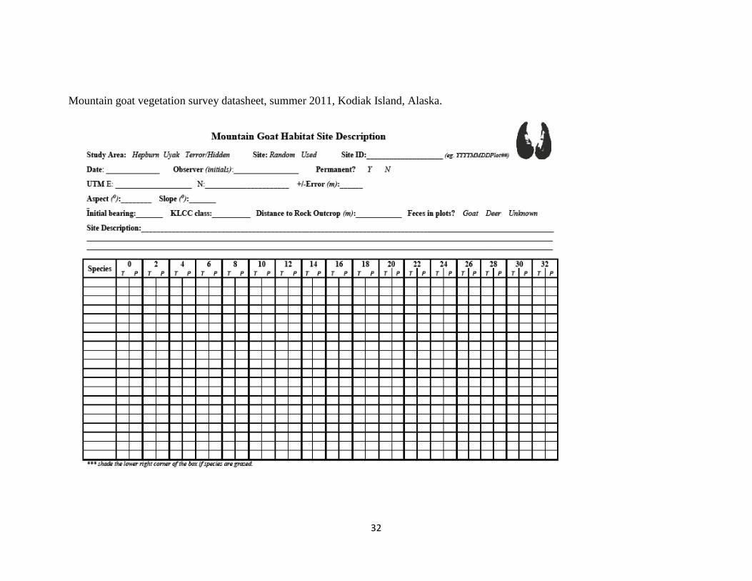
Mountain goat vegetation survey datasheet, summer 2011, Kodiak Island, Alaska.

33
APPENDIX 2
2011 Mountain Goat Field Summary
Heidi Helling, Biological Science Technician
Overview
The 2011 summer field season began June 2, 2011 and ended on August 19, 2011. Mountain
goats were sampled from 3 study sites as part of a pilot study to determine methodologies,
logistics, and the feasibility of each site. The principal investigator, McCrea Cobb was present in
the field with a field crew for the first half of the summer season. One field tech (Heidi Helling)
and 2 volunteers (Ross Dorendorf, Adia Stovie) were present throughout the entire summer field
season. The third volunteer (Aarin Sengsirirak) joined the field crew for the second half of the
summer field season.
Hepburn Study Site
Trip 1
June 2-9, 2011
Route of travel / Camp sites
McCrea Cobb, 2 volunteers, and I were dropped off at the tip of Hepburn Peninsula by Refuge
pilot, Kevin Van Hatten. We proceeded to hike up the eastern ridgeline of the peninsula and set
up camp night 1 just south of peak 2048 by about 1 km. We experienced extremely strong wind
speeds that night (~50mph), causing our cook tent to almost blow off the mountain and
damaging tent poles, so the following morning we hiked down in elevation into Hepburn Valley
to camp (UTM N444145, E6317596). The crew worked from this camp for 3 nights, and then
unfortunately moved camp during a second extreme wind/rain storm (X-tuffs, thermos and pack
covers were blown off our packs). That day, we hiked out from camp heading north intending on
reaching a cash of food located on the shore near the northern end of the peninsula. We traveled
along the eastern ridgeline, but to avoid the strong winds, dropped down into a bowl where the
western and eastern ridgelines merge. We camped in a lovely (not really) fern salmonberry side-
hill meadow at approx. UTM N446043, E6323161. The weather continued to be horrendous into
the following day, which we stayed in tents to try to stay warm and dry, then hiked down the
valley the following day to Ivor Cove where Refuge pilot Kevin Van Hatten picked us up. No
points could be accomplished the last three days, because of the weather conditions. Note:
vegetation on the western Deadman side of Hepburn is extremely thick in vegetation and
populated by Devil’s Club.
Work Accomplished
Being the first stint of a pilot season and with the adverse weather conditions in early June,
efficiency was not necessarily high. Potential goat populations and random location were not
accessed north of the midsection of the peninsula (which is where the western and eastern ridges
merge). Sampling methods were tested on 4 used sites and 17 random locations (Total: 21).
Four behavioral observations were conducted and 11 fecal samples were collected. See data for
specific points sampled. We revised our initial vegetative sampling from four 16 meter transects
(forming an “X”) to two 16 meter transect (a straight line) due to time needed to allocate towards
34
a T4 transect (~2hrs during a plant dormancy phase). Random locations were primarily reached
on the eastern and western ridgeline. Techs reported the western ridgeline is accessible during
this time of year, but to be cautious of steep drop-offs along jagged ridgeline. Snow was still
present down to ~1200 ft in elevation.
Mountain goat locations / on the ground herd populations estimates
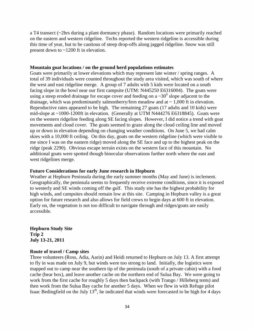
Goats were primarily at lower elevations which may represent late winter / spring ranges. A
total of 39 individuals were counted throughout the study area visited, which was south of where
the west and east ridgeline merge. A group of 7 adults with 5 kids were located on a south
facing slope in the bowl near our first campsite (UTM: N445250 E6316004). The goats were
using a steep eroded drainage for escape cover and feeding on a ~300 slope adjacent to the
drainage, which was predominantly salmonberry/fern meadow and at ~ 1,000 ft in elevation.
Reproductive rates appeared to be high. The remaining 27 goats (17 adults and 10 kids) were
mid-slope at ~1000-1200ft in elevation. (Generally at UTM N444276 E6318845). Goats were
on the western ridgeline feeding along SE facing slopes. However, I did notice a trend with goat
movements and cloud cover. The goats seemed to graze along the cloud ceiling line and moved
up or down in elevation depending on changing weather conditions. On June 5, we had calm
skies with a 10,000 ft ceiling. On this day, goats on the western ridgeline (which were visible to
me since I was on the eastern ridge) moved along the SE face and up to the highest peak on the
ridge (peak 2290). Obvious escape terrain exists on the western face of this mountain. No
additional goats were spotted though binocular observations further north where the east and
west ridgelines merge.
Future Considerations for early June research in Hepburn
Weather at Hepburn Peninsula during the early summer months (May and June) is inclement.
Geographically, the peninsula seems to frequently receive extreme conditions, since it is exposed
to westerly and SE winds coming off the gulf. This study site has the highest probability for
high winds, and campsites should remain low at this site. Camping in Hepburn valley is a great
option for future research and also allows for field crews to begin days at 600 ft in elevation.
Early on, the vegetation is not too difficult to navigate through and ridges/goats are easily
accessible.
Hepburn Study Site
Trip 2
July 13-21, 2011
Route of travel / Camp sites
Three volunteers (Ross, Adia, Aarin) and Heidi returned to Hepburn on July 13. A first attempt
to fly in was made on July 9, but winds were too strong to land. Initially, the logistics were
mapped out to camp near the southern tip of the peninsula (south of a private cabin) with a food
cache (bear box), and leave another cache on the northern end of Sulua Bay. We were going to
work from the first cache for roughly 5 days then backpack (with Trango / Hilleberg tents) and
then work from the Sulua Bay cache for another 5 days. When we flew in with Refuge pilot
Isaac Bedingfield on the July 13th
, he indicated that winds were forecasted to be high for 4 days
35
and scheduled to reach 38 mph. The southern end of the peninsula is the most exposed to
weather, so I decided to start field work based from the Sulua Bay camp. We arrived at Sulua
Bay and set up camp behind an alder stand for added cover (UTM N447932 E6320084). Camp
worked well in this area although at night we still had strong winds for ~3 days. On day 5 we
moved camp down the beach at low tide to the southern tip of the peninsula and made it to lake
65, which was about a 9 mile hike. The main reason for moving camp was Ross and I worked a
14 hr day (which meant getting back to camp at 12:15am) to reach goat populations on the
western ridgeline from Sulua Bay. This work was manageable, but not sustainable or efficient.
We were attempting to climb up into Hepburn Valley where we camped during the first visit, but
at this time of year all vegetation is leafed out, and from the southern tip of the peninsula, the
hike was another 4 miles through deceivingly diverse topography and head high vegetation.
Although this route looks easy to traverse on paper, I would not suggest this route for future
research. Camping at lake 65 was okay. We had water, but it was questionable since it seemed
so stagnant. One tech later contracted giardia, although the source was unknown. Bugs were
bad. But, the sunsets were beautiful. The day after we moved camp, McCrea and Isaac visited
us while conducting aerial goat surveys. Ross and I met the plane (Aviat Husky) on the beach
near the cabin, and Isaac shuttled us in the plane to lake 1035 located due west of peak 2290.
Here, goats were easily accessible and an ideal future camping spot was discovered. (Side Note:
When we camped at lake 65, two techs hiked to the western ridgeline towards goat populations
when Ross and I were being flown to lake 1035. They were quite successful in data collection,
and reported minimal bush-whacking. However, their work day was still 12 hrs.) On day 8, we
hiked east and north along beaches at low tide towards Sulua Bay to be in a more accessible spot
for airplane pick-up. Kevin was able to get us later that evening from Sulua Bay.
Work Accomplished
Despite the lack of a perfectly positioned campsite to work from, we still managed to get a ton of
work done. Camping far from goats meant 10-13 hr days, with one work day topping out at 14
hrs (no exaggeration, and these long days were also filled with mountain climbing). We
completed vegetation plots at 12 used sites and 26 random locations (total 38). We conducted 4
behavioral observations and collected 31 fecal samples. See data for specific points sampled.
The entire peninsula was successfully traversed to reach random locations, and we were able to
reached northern southern ends. Additionally, all ridges were accessed and data was reasonable
to collect from these areas.
Mountain goat locations / on the ground herd populations estimates
Observations indicated that goats on Hepburn Peninsula showed a strong site fidelity to the
western ridgeline south of the ridgeline merge. Goats moved throughout this region, but tend to
concentrate around peak 2290. Significant escape cover is characteristic of the western aspect of
this peak. A few lone goats were observed on the eastern ridge and at lower elevations (most
likely billies) during the aerial survey, but we did not spot these goat from the ground. Goat sign
was observed at the northern end of the peninsula, but it was minimal and likely represents only
a few individuals. Escape cover is not a significant part of the topography in areas where goats
were not observed. Herd estimates were difficult due to topography and timing of herd
movements, but at one time a total of 29 individuals were counted with 8 kids. I believe that this
estimate is low, and that numbers were similar to what we observed in early June (near 40
individuals). Compared to other study sites, reproduction does seem to be high in these areas.
36
My personal observation of this herd, in comparison to the Uyak or Terror/Hidden study sites, is
that goats look visibly younger. I was unable to get a good count of horn annuli for multiple
individuals to support this, but in general, the goats look quite young (thinner horns and
smaller/younger looking bodies). Also, goats in this region were seemingly perplexed when
approach by us and did not instantly run like in other areas. This difference in behavior might be
due to limited human interactions. We were sometimes able to get quite close to herds (~20 m),
so future behavioral observations are definitely feasible and our observed used sites are accurate.
The goats have created a well-worn trail along the western ridgeline, south of where the eastern
and western ridgelines merge, in the area that they seem to habitually use. They appear to be
quite weary if you have come between them and their escape cover, to the extent that they will
even approach an observer to reach escape cover. Primarily, goats appear to be selecting for
Long-awned sedge (Carex macrochaeta) at feeding sites, however Bistorta vivipara, Sedum
rosea, Lupinus nootkatensis (flowerheads), Erigeron peregrinus, other sedges species, Salix
pulchra, and Calamagrostis canadensis were also grazed upon at used sites. Lichen did not
appear to be grazed upon, but Cladina species where present in veg plots. This observation was
consistent across all study sites. Evidence of digging and areas of bare ground were observed
often at Hepburn, which was likely primarily to create bed sites. However, it appears this
behavior might also be related to goats foraging on roots because of the shape and depth of the
digs. Evidence of this behavior was even more prevalent at the Hidden Basin study area.
Future Considerations for July research in Hepburn
Overall, the trip was a success. Weather was sunny, clear, and a bit windy the first few days, but
we did not experience severe weather like the earlier Hepburn trip. Hepburn is a feasible study
site, but camp placement is a crucial determinant of work efficiency. I recommend two
campsites: the first at Lake 1035 (this would be more of a mid-late summer site) and the second
in Hepburn Valley near where we camped on our first trip. Goats could be easily accessed from
these sites, and both sites are relatively protected from inclement conditions that frequent the
region. Also, goats are typically in the southern end of the peninsula, so less time can be spent
scouring the slopes on the northern end of the peninsula. To reach Hepburn Valley, I would
recommend hiking from Sulua Bay (after July 1) or up from the tip of the peninsula (before July
1, and if a plane can get in there). Green up patterns dictate the choice of starting points. At
Sulua Bay, there would be an enjoyable (not really) several hours of swimming uphill in dense
salmonberry to reach the ridgeline, but this would be the most efficient approach. Since I know
a path of least resistance up that slope, it may not be too terrible with heavy packs. I believe that
the Deadman Bay side of Hepburn Peninsula is too densely populated with vegetation to easily
traverse, unless one hikes up the valley to Lake 1035. Overall, it is important to reach a
centrally-located campsite, even if doing that is arduous. Doing this significantly sheds hours of
rough hiking to reach locations and goats daily, which could lead to additional complications
(i.e. fatigue, knee injuries, hiking at night, and experiencing weather). Even from a spike camp,
hiking to goats and some random locations is difficult and fatigue, injuries, and weather
consistently come into play. After mid-season, there are no running streams in the highcountry,
so crews need to carry ample amounts of water with them. Unfortunately at Hepburn, camping
high on ridges is a recipe for getting your camp blown off the mountain, no matter what time of
year. But, the area is manageable, gorgeous, and has many goats that can provide data
representing selection patterns, since they seem to have tight site fidelity to a particular region
37
within the study area. It appears that they are heavily foraging at specific sites. Also the timing
of colonization of goats to this specific region makes for an ideal study site.
Uyak Study Site (Lake 629 Subregion)
Trip 1
June 14-17, 2011
Route of travel / Camp sites
This was our second trip of the season, and in hindsight, I think we were personally scarred from
the extreme weather conditions and arduous travel experienced at Hepburn. In that week at
Hepburn, we all lost a significant amount of weight (~6-10 lbs each!). In response, we attempted
to work from a basecamp at Lake 629 using two Bomb Shelter tents, camp chairs, a table, boot
dryers, cots, tons of food (bear box), and with no intention of moving camp. Camp was
comfortable and dry, but we were required to hike 12 hr a days to reach goats and random points.
We worked from this base camp and approached both mountain ranges to the north and south of
Lake 629 for several days. It should be noted that traversing up the southern mountain involves
committing yourself to serious bushwhacking, although the northern mountain has a semi-
established trail up the SE spine which we used to reach reasonable flat bench below the summit.
On this bench, we found several half frozen lakes which would make (and did during the 2nd
trip)
great spike campsites.
Work Accomplished
At this juncture, the study site was still ambitiously large, and our time was primarily served as a
reconnaissance mission for future research. We completed vegetation plots at 2 used sites and 6
random points (Total = 8), conducted 2 behavioral observations, and collected 12 fecal samples.
The majority of the random plots were accessed on the northern mountain, while the southern
mountain remained largely inaccessible during this time of year due to steep and icy terrain.
Climbs from base camp required crews to hike up to 3000 ft or more. The north side mountain
peaks at 4,300 ft, but the snow line was at 2,000-2,500 ft.
Mountain goat locations / on the ground herd populations estimates
One single billy goat was observed on the mountain south of Lake 629 (UTM N463575
E6362498) on June 14. Larger groups were located on the southern aspect of the northern
mountain at about green up elevation (2,000-2,500 ft). Here, goats were foraging just above the
salmonberry- alder line. We spotted a group of 18 goats (UTM N461776 E6366743), which
were feeding east of some escape terrain. When approached, the group traveled upslope towards
another group of 22 (UTM N461866 E6367249) that were also feeding adjacent to escape terrain
(to the west). The combined group had 7 kids. Goats here were approachable, and we were able
to get 80 m from the initial group of 18. We collected fecal samples from this group. The goats
have made a well-worn trail along the spine of their feeding site and the adjacent escape terrain.
As we approached our first used site, 3 goats were still below us and instead of giving us a wide
birth and walking upslope and away from us, their behavior indicated there was a need to group
up with the larger group. This was the first time I realized how “hard-wired” goats are in terms
of their landscape use. The goats approached us along this trail (looking perhaps confused
and/or worried), using the established trail to reach the other herd. One of the two used sites was
38
primarily composed of Empetrum nigrum, with Carex macrochaeta. I noticed (which may not
entirely be true) what appeared to be a lack of moss species and seemingly dry soil at used sites.
The other used site had a bit more alpine forbs present. We observed several beds dug into the
slope, and a large amount of goat hair was caught among willow branches surrounding the site.
Future Considerations for June research at Uyak- Lake 629
More in-depth details discussing this study site are mentioned in the Trip 2 portion of this
summary. Most importantly, a spike camp is necessary for this study site. There are several
lakes located along the eastern side of the northern mountain which are not completely frozen at
this time of year. The southern mountain has potential spike camps sites located at
approximately UTM N466466 E6361171. The use of ice axes is necessary at this site during this
time of year.
Uyak Study Site (Lake 629 Subregion)
Trip 2
July 29- August 7, 2011
First 5 days – Lake 629
An aerial survey was conducted prior to our second stint in this region. Results indicated that the
vast majority of goats were located on the northern mountain, while several goats were located
on the southern mountain. The study site was initially designed to have crews visit both the
northern and southern mountain. Given the 5-day time constraint, I decided to concentrate
efforts to one of the two mountains. The northern mountain was selected primarily due to the
greater goat occupancy.
Route of travel / Camp sites
Kevin dropped us off on the eastern shore of Lake 629, and we approached the northern
mountain. We hiked the same route traveled on our first visit (the SE spine where there is an
overgrown established trail). We were carrying 65-70lb packs. We set up a spike camp near the
largest lake on the bench (UTM N464837 E6366401), which took us about 3 hours to reach. The
campsite was ideal and should be used for subsequent field seasons. The northern mountain
peaks at 4,354 ft., however, reaching it from our spike camp was seemingly easy. This mountain
is not especially steep, except for some parts of the northern aspect. We summited this peak on
several occasions and the views were amazing. After the first round of study site visits, McCrea
and I decided to limit the extent of study sites to regions more realistically covered over 5-day
stints. Random locations occurred across the mountains bench, on all aspects, and NW along the
ridgeline to approximately (UTM N462087 E6368650). Since we were based from a spike
camp, traversing the extent of the study site was feasible and efficiency increased dramatically.
We approached the peak by side-hilling the mountain, hiking up the SE spine, and hiking up the
western face (bit steeper) and all was feasible. On day 5, we hiked down to Lake 629 (no data
was collected on this day) in hopes to get picked up to get moved to the Brosis Valley site (the
next study site). We followed the same route that we took on the initial ascent. The weather was
poor; we hiked in rain, which only stopped for a few hours in the afternoon while we were
waiting for Kevin at Lake629 and allowed some gear to dry. Conditions remained windy,
preventing a pick-up that day. Conditions were still marginal until mid-afternoon the next day.
39
Kevin picked us up around 3pm and transferred us to the Brosis Valley site (the drop off site is at
sea level). After shuttling the crew twice to get out of Lakae 629 and repacking gear, it was
evening and weather conditions were again deteriorating (wind, rain, and fog). Therefore, we
camped for the night at the drop off location.
Work Accomplished
We had a campsite that was ideally positioned and allowed high work efficiency. Crews
averaged about 7 points per day, which helped with crew moral. On our first day after we hiked
up to our spike camp, we were able to visit 5 random locations that were relatively (very) close
to camp. We completed vegetation plots at 10 used sites and 30 random locations (Total = 40),
conducted one behavioral observation, and collected 38 fecal samples. We would have liked to
have conducted more than only one behavioral observation; however, I initially stressed the
importance of collecting used site data as a higher priority to the behavioral observations.
Mountain goat locations / on the ground herd populations estimates
Aerial surveys indicated that the region east of Uyak Bay held some of the highest mountain goat
densities on Kodiak. On Mt. 4354 (north of Lake 629), our largest group totaled 55 individuals,
which included 11 kids. This group was located at approximately UTM N 461977 E 6368103. I
believe that this particular group (which was observed after Tim and I found them around at a
location ~500 m to the NW along the ridgeline) was a near census of goats on the mountain (with
perhaps an additional ~10 uncounted). Billies at this time of year were generally spotted near
nursery groups, bedded or feeding alone, or a bit further down slope (~50-150m). At other times
they are with the larger group, such as the group of 55. During our visit, a group of ~20 goats
were visible from Lake 629 (before we hiked up) near the summit on the SE aspect. In one day,
they moved further back along the ridgeline and were located near the furthest extent of our
study area (See UTMs above). The NE aspect of this ridgeline has (seemingly) ideal escape
terrain for goats. Goats were observed feeding on ridgeline where terrain was relatively flat, but
adjacent to cliff band. Goats primarily stayed in this region for the duration of our stay. Plant
species grazed upon was once again primarily Carex macrochaeta with sign of grazing on
Bistorta vivipara, Sedum rosea, Lupinus nootkatensis (flowerheads), Erigeron peregrinus,
various other sedges, and Calamagrostis canadensis. I completed several used site plots (while
working with Tim) at these locations, and observed an abundance of Cladina spp. lichen in plots
and the surrounding area, but not much of Carex macrochaeta (which is usually dominant at
used sites). When goats were approached, they appeared to be a bit spookier than Hepburn
goats, although we were getting closer to the hunting season opener. Perhaps this influenced
behavioral patterns. Even still, we were able to still get within ~40 m. Tim and I were on the
cliff-band edge and approached to about 4 m from a nanny and kid who were using a steep trail
just beneath us to move away from our tape measure. From this experience, I realized that it
could be possible to run down a kid (and collar it). But, I am not so sure how the nanny would
react. Overall, mountain goats in the region were generally accessible; plenty of them from
which record used site data ad gather fecal samples. The goats were approachable.
Future Considerations for July-August research at Uyak-629 (Mountain 4354)
Well, I believe that this visit was a success, taking into account the 5-day time frame. Regardless
of the advantages of the spike camp and the relatively easier terrain to navigate, we still worked
10-12 hr days to take advantage of the great weather and the seemingly endless opportunities to
40
approach goats. The long days felt less exhausted since more time was spent at plots (sitting)
rather than hiking (the size of the study site was more reasonable). I would recommend
conducting field logistics in this area similarly in the future. I would, however, recommend
extending the duration of the trip to enable us to visit more used and random site locations.
Uyak (Brosis Valley Subregion)
Trip 2 (1st for Brosis Valley)
August 2 – 7, 2011
Route of travel / Camp sites
As mentioned above, we arrived at the base of a drainage which heads up the 1800ft hillside that
leads into Brosis Valley late in the day and with worsening weather conditions. We camped at
the drop-off location for one night, and then hiked up Brosis Valley to establish a spike camp the
next day. The valley lies at the base of 3,700-4,000 ft mountains. Vegetation from sea level to
approximately 1,800 ft was HEINOUS; thick and overgrown. It almost looks impassible, or
passible with foresight of one becoming seriously irate towards the ridiculous overgrown plants
that seem to be hopped up on fertilizer. It was the thickest vegetation that I have encountered in
3 summers on Kodiak. I personally committed myself to not speak to anyone during the hike up,
or severe negativity might have spewed out. The south side of the drainage for some reason
looked marginally manageable. In reality, there was a network of establish bear trails that we
followed, making the experience manageable. The trail that we followed led to the south and
then up hill. By no means is there a trail all the way up, but the bushwhacking in this region
could have been much, much worse without this trail. So, the hike up is quite feasible. We
establish a spike camp (UTM N 453843 E 6366463) on the south side of Brosis valley. The
valley is large and largely populated with chest high willows, so I would suggest this campsite.
The campsite worked quite well, it was near several streams and protected from high winds.
Much of our work was based at the back end of the valley, over the ridge into the nest bowl (SE),
and along the southern ridgeline.
Work Accomplished
Similar to the second Lake 629 trip, this trip was a success and the only limiting factor was time.
We completed vegetation plots at 11 used sites and 24 random locations (Total = 35), conducted
5 behavioral observations, and collected 22 fecal samples. The terrain was a bit steeper than the
Lake 629 site, but manageable. We typically worked 10hr days (which were incredibly
rewarding) and were able to access most locations. Once again, more time in the field was spent
conducting vegetation surveys, so physical fatigue wasn’t too bad.
Mountain goat locations / on the ground herd populations estimates
Goats occupied the ridgeline south of Brosis Valley. For our first night at the spike camp, three
single billies were observed on the north face of this ridgeline. The following day, a group of 11
goats (no kids) were observed just below Peak 4064 on the NW aspect on a small linear patch of
vegetation among scree. Adia and I hiked to this location and later found a group of 25, 12 and 7
on the southern aspect of peak 4064. The group of 7 were bedded further east along the ridgeline
on a scree slope. The group of 25 goats were observed on the southern aspect (directly
downslope) from peak 4064. Some goats (~12) were bedded on scree, approximately 45m from
41
the remaining goats who were feeding in a vegetated chute that ran down the mountain side.
Another group of 12 were feeding on the SW aspect approximately 200m from the group of 25
(See data for specific used site UTM locations). The goats were approachable, and we were able
to get ~50 m from the nearest individuals. A group of 6-7 goats were spotted east of Brosis
Valley near the eastern edge of our study site (UTM N 456641 E 6364813, in a bowl). An aerial
survey conducted less than 2 weeks prior observed the majority of the goats in this study site
were at this location. I’m assuming the larger groups we saw were the same individuals located
during this aerial survey.
Future Considerations for July-August research in Brosis Valley
This was my favorite site. A spike camp is essential for mountain goat work in this area. I
would also recommend spike camping from the initial spike camp, perhaps with minimal gear
(bivy), to enhance data collection opportunities. Data collection is feasible on all ridges and
mountains. On marginal weather days, inclement conditions tend to sit at the far eastern end of
the valley (something to consider when considering camp sites) and also the southern ridgeline
(which could be due to the fact that it is significantly higher in elevation than the northern
ridgeline). Work efficiency was high, with an average of 7 vegetation surveys per day, per team.
Our only limitation was time, so I would suggest a longer site visit.
Hidden Study Site (Terror Lake Subregion)
Trip 1
June 21-26, 2011
Route of travel / Camp sites
We operated out of a base camp established on the road on the northeastern short of Terror Lake
(UTM N 499844 E 6388815). We used two Bomb Shelter tents, camp chairs, and bear box for
food storage.
We hiked to random locations along the southern mountain rising from Terror Lake, the large
snow basin south of this mountain, and on Shotgun Ridge. McCrea, Ross, and Adia also visited
the mountain range NW of Terror Lake, which was approached by an extremely long (3hr round
trip) road walk and a climb to approximately 3,600 ft. To approach the snow basin and other
areas south of Terror Lake, we walked the road. Snow was extremely prevalent. McCrea and I
traveled throughout the snow basin and Shotgun Ridge, and managed to remain on snow for the
entire work day. Skiing at this site (specifically south of Terror Lake) for the first trip would be
the most effective way of travel, and should be implemented into subsequent field seasons. The
western aspect of shotgun ridge remained largely inaccessible (cliffs) but possibly could be
accessed via a bowl to the south. The mountain range to the north of Terror Lake was visited to
access a used site, and the mountain to the NE of Terror Lake was accessed for random and used
locations. Travel was relatively easy, bushwacking is minimal, and longer distances can be
covered more efficiently at this site.
Work Accomplished
We completed vegetation plots at 3 used sites and 47 random locations (Total = 50), conducted 3
behavioral observations, and collected 15 fecal samples. A large portion of the random sites
were snow.
42
Mountain goat locations / on the ground herd populations estimates
A group of 12 goats were observed at about 2,500 ft on the western aspect of Shotgun Ridge.
This location was characteristic of the green up line at this time, and this aspect could be
considered typical goat escape cover. Large cliffs dominated slopes with intermittent shallower
bands of vegetation above more cliffs. Goats at this site were seen bedded/foraging along
benches, which later moved further down slope and used areas adjacent to steep eroded
drainages. Mid-slope eroded drainages are a consistent land feature of many mountains across
Kodiak Island. Goats were also observed from camp on the NE slope of the mountain range
west of Terror Lake. This included a single billy and a group of ~10 that were using a ridgeline
or an area just below to feed. When crews visited this site, they observed a larger group further
down the valley on the next mountain to the west that could not be accessed within a day trip.
Another group of 3 goats (2 nannies and 1 kid) were observed from the road just NE from camp.
goats are rarely seen on this mountain, but it appears to be used by goats for dispersal to adjacent
ranges (tracks in the snow observed). No adequate escape terrain exists on this mountain range.
The valley to the NW may be used as a corridor for goats to access the range north of Terror
Lake. Goat hair was found in this valley among willow branches. The approach to the northern
range took 8 hours and we recorded 2 used sites. Once again the goats were at roughly the same
elevation as those on Shotgun Ridge (2,500 ft line and on the green-up transition line). This used
site was similar to others (i.e. elevation, species present, aspect, distance to escape cover) except
that we observed a significant bed excavated by goats. As we approached, two goats were both
laying in the bed. The excavated site was 5 feet in length, 2 feet wide, and about 2 feet deep. All
goats were approachable to close range. We approached this group to within 100 m.
Future Considerations for June Research at Terror Lake
My suggestions to increase efficiency at this site are listed below in the Trip 2 section. During
the early season, I recommend using skis to reach locations within the region south of Terror
Lake (and it would be fun).
Hidden Terror Study Site (Hidden Basin Subregion)
Trip 1
June 27-July 1, 2011
Route of travel / Camp sites
We camped using the same gear as we did for Terror Lake, and once again worked from a base
camp. We set up our campsite at UTM N 505419 E 6374161. This site is characterized by a
long north-south ridgeline running from Hidden Basin towards Crown Mountain, with high
alpine bowls and steep slopes. There is an established trail up the SE spine of the ridge, so we
did not have to navigate through thick vegetation. However, we were climbing a cumulative of
~3,500-4,000ft daily, and descending the same distance. The crew fatigued quickly. We were
not able to access regions north of the second bowl (Twin Lakes), and I think this was a product
of long days of hiking. There are steep and snow-covered regions that makes this site a bit more
inaccessible this time of year for data collection. Some points were on >500 slopes, which were
dangerous to traverse at this time of year without mountaineering gear.
43
Work Accomplished
We completed vegetation plots at 4 used sites and 13 random locations (Total 17), conducted 2
behavioral observations, and collected 15 fecal samples.
Mountain goat locations / on the ground herd populations estimates
We found two distinct groups of goats on south facing slopes near the “first” and “second” bowl.
I’ll refer to the second bowl as Twin Lakes since there are two lakes (creative). A group of 10
goats was observed on the NE spine of the first bowl and later moved up near the peak. This
area was snow-free, being a southern aspect. Another group of 10-12 goats was observed on the
NW spine of the Twin Lakes bowl in one of the few snow-free locations. No kids were observed
in either group. At used site locations, it appears that the goats had dug up significant portions of
the ground. Bare ground resulting from goat digging appeared more prevalent at this site than
other study sites. It appeared that goat beds have been dug up over longer periods. We also saw
evidence of goats pawing at the ground, possibly for roots or minerals. A well-defined trail runs
along the spine of the areas where goats were observed, and along the ridge line to the two
bowls. Therefore, it appears that goats use the entire ridgeline within the study area. Like at
other sites, goats were approachable to close distances.
Future Considerations for June / July research at Hidden Basin
A spike camp was needed. During this period, the first bowl is relatively snow-free and would
have been an ideal location for camping. Water was available. The Twin Lakes bowl was still
completely frozen. Accessing goat locations from a basecamp at sea level was not efficient, and
there is too much elevation change to maintain the crew. Contrary to other members of the crew,
I believe the steep face on the north end of Twin Lakes (“The Wall”) is climbable this time of
year (did not attempt it this stint). The long approach from sea level tired the crew and made it
look more arduous than it actually is. Even still, an unarrested fall down The Wall would send a
person into a half frozen lake. Like for other sites, I suggest a longer trip that would allow for
more data collection opportunities and give us a larger window for marginal weather conditions.
I also recommend camping in the first bowl (with lots of warm clothes) and carrying ice axes.
Some areas will take time navigate due to the terrain (steep and need good weather). With a
longer trip, we could focus on data collection in difficult locations for selected days without
feeling rushed. This actually speaks for all study sites!
Hidden Terror Study Site (Terror Lake Subregion)
Trip 2
August 11-15, 2011
Route of travel / Camp sites
We used the same campsite as the first trip. Unlike the first trip, the road was now snow-free
and being used by KEA for maintenance. After speaking with them, we camped on the road
shoulder to be out of the way. The campsite was great. Routes of travel were the same as the
first trip and a bit easier since it was predominantly snow free. Except ….once I arrived to the
site for the second trip I decided to focus efforts on the ridgeline west of crown mountain
(Shotgun Ridge). At this point in the season, I found that when efforts were concentrated to a
particular region more data was collected, especially used sites. I choose this ridge because it
44
was closest to the site of introduction (Crown Mountain) and closer to the Hidden Basin study
site. The mountain range to the west of Terror Lake (where previously we saw groups of goats)
required a spike camp to effectively collect data. This can be done, if more time is allotted.
Work Accomplished
We completed vegetation plots at 13 used sites and 37 random locations (Total = 50), conducted
2 behavioral observations, and collected 40 fecal samples.
Mountain goat locations / on the ground herd populations estimates
One billy was located on the mountain range west of Terror Lake and visible from camp. As
stated earlier, we did not collect data from that region. For several days, we collected used site
data from two groups who were occupying Shotgun Ridge and the adjacent steep cliffs that are
characteristic of its western aspect. A group of 18 goats with 5 kids were located at
approximately UTM N503439 E6386607 and another group of 6 with 0 kids further north
(approximately UTM N 504178 E 6388658). I approached the group of 18 goats and noticed
that as the group size increased, they became more comfortable with our presence. At one point,
a younger billy slowly approached us to further investigate and came within 12 m. The goats
were primarily located on Shotgun Ridge and appeared to be feeding on Carex macrochaeta
among bedrock. The wide ridgeline was mostly free of vegetation except for a brim along the
ridgeline. On Aug. 12, we saw a group of 12 goats on the ridge, and two groups of 4 and 6 goats
below and at the same contour line where they were observed in June. The group of 6 goats
further to the north was using sites near the ridgeline, similar to the group of 18 goats. At several
used sites, I noticed excavated areas at which the goats appear to be digging to get roots. These
regions are characterized by low hummocks and sparse vegetation intermixed with bedrock.
Hummocks have been dug parallel to the ground surface (much like a burrow) leaving an
overhang of vegetation and exposed roots. It appears that the goats may be selecting for roots
and/or minerals. I took pictures of this site and additional “excavated” sites at the Hidden Basin
study site. Surrounding the hummocks, I observed significant amounts of bare ground and
wondered if this was evidence of goat impacts to the environment in an area for a significant
time period. Bare ground is not found on ridges where goats were absent and bare rock was
minimal in this area. Why is vegetation not growing within the matrix of bare ground?
Future Considerations for August research at Terror Lake
Unless more time is allocated to the site, data collection should be focused on the ridgeline
adjacent to Crown Mountain (Shotgun Ridge) to attain vegetation composition data nearest to the
site of introduction. The eastern aspect of the ridge is steep, leaving few routes that are feasible
to descend. Down-slope of UTM N 503439 E 6388815, there is a safe route to reach a bench (I
did a used site along this slope). I would advise not attempting any down climbing in clouds or
rainy weather. Another route on/off the ridge is south where the cliffs shallow out into a bowl
(Steve at Orion’s has skied down this bowl). A third option is to camp at Crown Mountain and
approach this slope from the bottom, which may be easier. However, camping on Crown would
require a helicopter drop-off or another spike camp further back from Hidden Basin (this would
be more feasible in late summer). The geology surrounding Terror Lake is granite (i.e. the
mountains directly S and E of the lake), so this should be taken into consideration when
comparing veg composition across study sites. Ice axes were not necessary this time of year.
45
Hidden Terror Study Site (Hidden Basin Subregion)
Trip 2
August 15-19, 2011
Route of travel / Camp sites
Kevin flew us directly from Terror Lake to Hidden Basin on the morning of the August 15. The
sunny weather made the hike up to our spike camp enjoyable. It took about 4.5 hours to reach
the area, and then another 2 hours to find perfect camp site. Similar to our first trip, we hiked the
SE spine of the mountain, where there was still an established trail that was not too overgrown
with vegetation. We then took the ridgeline north, and Adia and I dropped down into the first
bowl to get water and to avoid a section of the ridgeline that cliffs-out and appeared somewhat
unsafe to traverse with heavy packs on. We hiked out of the bowl and into the second bowl,
which we named “Twin Lakes”. Aarin and Ross managed to hike the ridgeline with heavy
packs. This section is crossable, but handing off packs and the shotguns for two different
sections is helpful….well, necessary. We camped on the north side of the lakes at UTM N
504780 E638245. The camp site was absolutely gorgeous and the western lake had a white sand
beach. The weather was sunny and clear for the following 3 days, albeit a bit windy the first day.
We were able to access areas north of “The Wall” which is the low point on the bowl’s northern
ridgeline, and areas north of this point continued to be high in elevation, but accessible. We
were able to collect data from as far south as the first bowl to back north of a third bowl. The
eastern face of the ridge east of Twin Lakes bowl is extremely steep. There is also a significant
gorge which does not show up on topographic maps or the GPS. Impressively, goats definitely
use this region as we saw evidence of their presence (beds, trails, hair, and feces). Aarin and I
hiked down-slope as far as we could to reach a random location, but had to retreat to the
ridgeline. Ross and Adia were able to hike the ridge NW of Twin Lakes bowl. This route can be
traveled on future trips.
Near the end of our stint the weather deteriorated. The day before we were scheduled to
fly out (August 19), we waited in a fog (visibility: trace, Rain: X) and the weather intermixed
from mist to down-pouring rain. I thought that it would not be safe to hike the ridges in this
condition, so we completed a few random locations (5) near the bowl in which we were camped.
The weather continued to be poor the following day (fog and mist) but we hiked down to Hidden
Basin the same way that we hiked in. We made it to sea level in about 4 hours. We all hiked
down into the first bowl to avoid the cliffed-out region along the ridgeline. On the hike down,
we did not experience too many troubles with slippery wet vegetation because we stayed on an
established trail. Kevin was able to pick us up the evening of August 19, after the cloud ceiling
lifted a bit, which was the day before the opening day of the mountain goat hunting season.
Work Accomplished
We completed vegetation plots at 12 used sites and 26 random locations (n = 39), conducted 4
behavioral observations, and collected 20 fecal samples.
Mountain goat locations / on the ground herd populations estimates
Four mountain goats were initially observed bedded on a snowfield (hot sunny day) on the
ridgeline east of Twin Lakes bowl. Another 3 goats were also bedded on a small snow field on
the eastern aspect near the ridgeline NW of Twin Lakes bowl. Observations during subsequent

46
days indicated that the goats had moved further back (north) near UTM N 505746 E 6380206 on
existing ridgelines which were higher in elevation, had snow which they used to bed on, and
adjacent steep cliffs. Areas where goats feed were easily accessed. The weather was blazing sun
and quite warm (70s). It appeared the goats were trying to compensate for this by bedding in
snowfields. By 10:00am they had moved onto a shaded NW facing slope. Like other area, goats
in this region were approachable. My best approximation for the number of goats in this region
is 46 adults (no kids). Adia and Ross indicated that they saw one kid, but they also verbalized
the individual had horns, leaving me to believe that the individual was most likely a yearling.
We took pictures of evidence of digging behavior on the ridgeline near the UTM listed above.
My hypothesis for this behavior is indicated above (see Terror Lake Trip 2). Bare ground at this
site was quite pronounced. At used sites, the goats appeared to be selecting for Carex
macrochaeta, Bistorta vivipara, Sedum rosea, Lupinus nootkatensis (flowerheads), Erigeron
peregrinus, and various other sedges. We did not observed lichen that was grazed upon, but the
presence of Cladina species in vegetation plots was assumed to be foraged. Goats were
generally bedded on NW facing slope (cooler temps) and foraging in areas largely dominated by
bare rock. It was noted that vegetation species diversity was quite high at used sites, based on
vegetation plot data, and appeared to be quite different than random sites.
Future Considerations for August research at Hidden Basin
Our visit managed to fall within a high pressure weather system, so clear sunny skies made data
collection feasible. Like at other study sites, we were limited by time. I would suggest a longer
trip in the future. Longer trips would also compensate for marginal weather days, when data
collection is more difficult or impossible. Some random locations took a long time to access
(steep) so a longer stint would allow crews to access more random points. The campsite location
was ideal and should be reused in future seasons. It appeared that our presence camping in the
Twin Lakes bowl did not disturb nearby goats. I would also recommend spike camping further
north towards Crown Mountain if/when there is a weather “high” for a few days. This may give
us access to Shotgun Ridge (see associated recommend in Terror Trip 2). Although we planned
to, we were unable to collect data from permanent plots or random locations further south along
the ridgeline due to the weather conditions on our second to last day. Overall, our trip was a
success and the study site was quite manageable.
47
APPENDIX 3
2011 Mountain Goat Field Summary
Ross Dorendorf, Volunteer Field Assistant
Hepburn Study Site
Hepburn was somewhat difficult logistically. I think each stint could be different, in terms of
where to camp, and where data collection is feasible. Our first trip to Hepburn was daunting, but
we learned a great deal about what is possible.
The goats were much lower early in the season than late, and we located several areas where they
concentrate early on in the season. They seemed to be very accessible from the valley in between
the eastern and western ridges. A possibility for next season would be to get dropped off close to
the southern end (weather permitting), and hike up to the second camping location (near the
northwest part of the valley). Here the crew could work on the northern section of the valley. The
western facing slope of the western ridge seemed to be a bit sketchy early on with the amount of
snow cover and cliffed out locations. There were many goats that were easily accessible to us on
the lower end of the eastern slope of the western ridge. After spending 5 days there, the crew
could move camp to a location near the western facing slope of the eastern ridge, possibly near
the bowl on the southern end where goats were earlier in the season. The second location may
need a food drop, but that could be done on the initial flight in. The crew could work on the
southern end for 5 days, after that they could hike back down to the southern end of the
peninsula and walk the beach heading northeast towards Saloua Bay. Saloua Bay is a better
location for pick up and drop off with the beaver, especially given Hepburn’s reputation for
crummy weather.
On the second trip to Hepburn, the goats concentrated on the western ridge. This might sway
how much work you do on the eastern versus the western ridge. When Heidi and I got dropped
off at Lake 1035, right away we knew that camping in that area would be a huge advantage.
Getting flown to the lake would be great, hiking up to the lake would work, and both options
come with the disadvantage of having to land the plane either in Deadman Bay or Lake 1035. If
possible, this would be a very productive area for the second trip to Hepburn. If the eastern ridge
were to be worked again, it may be possible to hike from Lake 1035 to the other ridge, though
this would also require an airdrop of food somewhere up high. I would talk to Heidi about
camping up there. I don’t think there are many opportunity for used sites on the eastern ridge
during the second stint. We did not find any goats, or fecal samples there this year. Nonetheless,
it still provides comparative data for vegetation plots.
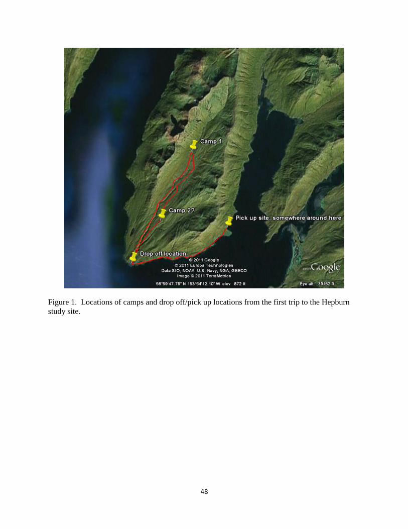
48
Figure 1. Locations of camps and drop off/pick up locations from the first trip to the Hepburn
study site.
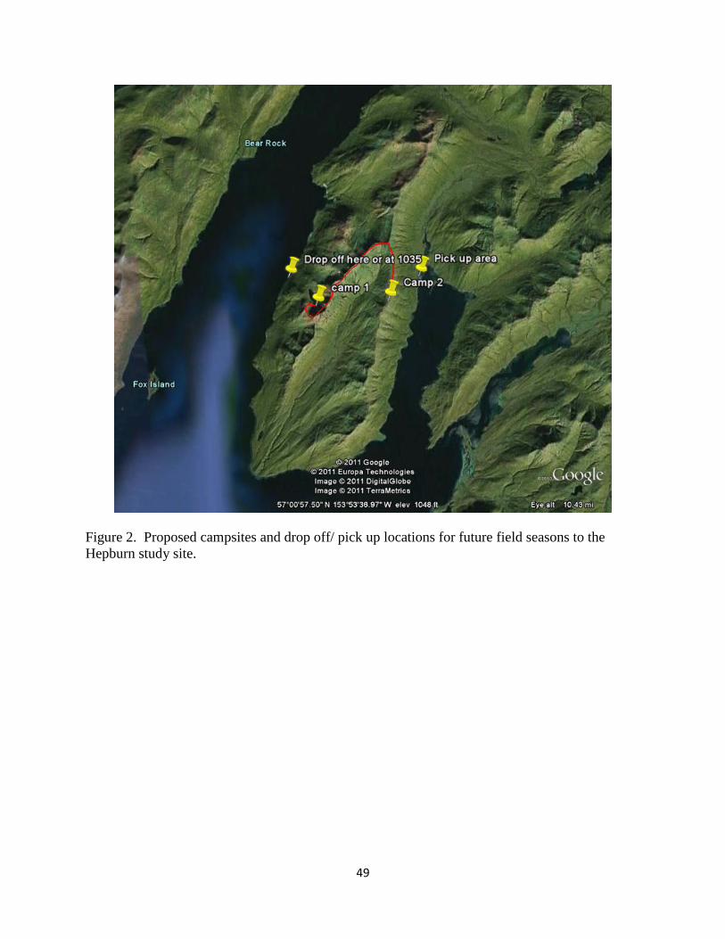
49
Figure 2. Proposed campsites and drop off/ pick up locations for future field seasons to the
Hepburn study site.
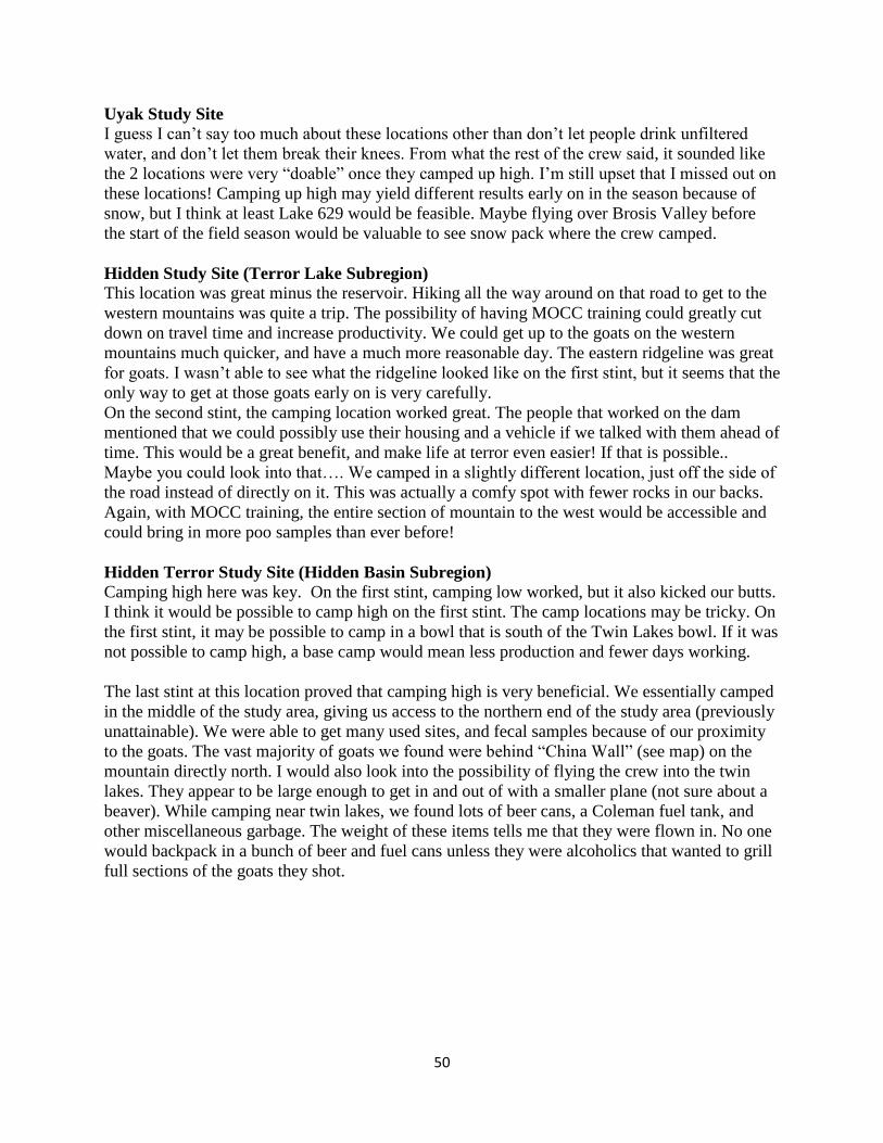
50
Uyak Study Site
I guess I can’t say too much about these locations other than don’t let people drink unfiltered
water, and don’t let them break their knees. From what the rest of the crew said, it sounded like
the 2 locations were very “doable” once they camped up high. I’m still upset that I missed out on
these locations! Camping up high may yield different results early on in the season because of
snow, but I think at least Lake 629 would be feasible. Maybe flying over Brosis Valley before
the start of the field season would be valuable to see snow pack where the crew camped.
Hidden Study Site (Terror Lake Subregion)
This location was great minus the reservoir. Hiking all the way around on that road to get to the
western mountains was quite a trip. The possibility of having MOCC training could greatly cut
down on travel time and increase productivity. We could get up to the goats on the western
mountains much quicker, and have a much more reasonable day. The eastern ridgeline was great
for goats. I wasn’t able to see what the ridgeline looked like on the first stint, but it seems that the
only way to get at those goats early on is very carefully.
On the second stint, the camping location worked great. The people that worked on the dam
mentioned that we could possibly use their housing and a vehicle if we talked with them ahead of
time. This would be a great benefit, and make life at terror even easier! If that is possible..
Maybe you could look into that…. We camped in a slightly different location, just off the side of
the road instead of directly on it. This was actually a comfy spot with fewer rocks in our backs.
Again, with MOCC training, the entire section of mountain to the west would be accessible and
could bring in more poo samples than ever before!
Hidden Terror Study Site (Hidden Basin Subregion)
Camping high here was key. On the first stint, camping low worked, but it also kicked our butts.
I think it would be possible to camp high on the first stint. The camp locations may be tricky. On
the first stint, it may be possible to camp in a bowl that is south of the Twin Lakes bowl. If it was
not possible to camp high, a base camp would mean less production and fewer days working.
The last stint at this location proved that camping high is very beneficial. We essentially camped
in the middle of the study area, giving us access to the northern end of the study area (previously
unattainable). We were able to get many used sites, and fecal samples because of our proximity
to the goats. The vast majority of goats we found were behind “China Wall” (see map) on the
mountain directly north. I would also look into the possibility of flying the crew into the twin
lakes. They appear to be large enough to get in and out of with a smaller plane (not sure about a
beaver). While camping near twin lakes, we found lots of beer cans, a Coleman fuel tank, and
other miscellaneous garbage. The weight of these items tells me that they were flown in. No one
would backpack in a bunch of beer and fuel cans unless they were alcoholics that wanted to grill
full sections of the goats they shot.
51
Figure 3. Map of potential camp site for the first trip in future field seasons to the Hidden Basin
study site.
52
Additional Suggestions
In the future, 10 day trips may not work so well due to weather. We were extremely fortunate
this summer with our blue bird days. Lengthening our trips may work to avoid working in crappy
conditions. On the other side I thought that 10 days was effective. It was plenty of work on the
body, and time to rest between stints was beneficial.
Only the data can tell us if we are getting the information we need or not, but shortening
transects to 20 meters may work out. This is the length that I used while in Colorado, so I’m not
sure if it is applicable to Kodiak.
It was very difficult to find permanent locations when revisiting sites. We also forgot to keep the
original bearing with us, so on several occasions we had to pick a random bearing. I’m not so
sure that will work well for data analysis. Maybe something could be attached to the stake to
make it more visible. Or use a Trimble for those locations to get more accurate points.
At the beginning of the year it may be beneficial to do multiple trips with Stacy Studebaker, or
more training in general for plant identification. When attempting to identify plants down to
species, it is important to have a basic concept of plant anatomy and plant taxonomy. Also, a
dichotomous key would be valuable in the field. I’m not sure if there are any field guide sizes
available for Alaska’s flora, but they are very beneficial when you only have a leaf to deal with.
I don’t know if this is possible, but climbing gear may be beneficial to get to the points that were
previously unattainable. This may reduce bias in the overall study. Again I’m not sure the
USFWS would be ok with it, but it’s an idea.
Food was a huge moral boost at the end of the day. Sitting down at the beginning of the year and
creating a food list with a little of what everyone wants can make a huge difference to the overall
season. A food list is important to have when packing food for the stints. Some crew members
didn’t see the value in taking time to do this, resulting in food being forgotten….(POP TARTS!).
Aside from all these picky comments, I just wanted to say how impressed I was with Heidi. Her
prioritization of what to do on a day to day basis was superb. She was also very good at resolving
tension in camp, and with problems that arose in town. Her positive attitude made this summer a
blast!