knowledge stream summer issue 2016-03 · subscribe to the knowledge stream by sending an email to:...
TRANSCRIPT
Knowledge StreamResearch and Development Office Magazine
Summer 2016-03
Climate Variability and Extremes

Research and Development Office Contact Information
Levi Brekke Chief 303-445-2494, [email protected]
Chuck Hennig Deputy Chief and Prize Competitions Coordinator 303-445-2134, [email protected]
Ronda Dorsey Programs Information Specialist 303-445-2624, [email protected]
Jennifer Arends Budget Analyst 303-445-2231, [email protected]
Samantha Zhang Technology Transfer Administrator 303-445-2126, [email protected]
John Whitler Science and Technology Program Manager 303-445-2241, [email protected]
Science and Technology Research Coordinators
Yuliana Porras-Mendoza Advanced Water Treatment and Desalination and Water Purification Research Program Manager 303-445-2265, [email protected]
Erin Foraker Renewable Energy and Infrastructure 303-445-3635, [email protected]
Ken Nowak Water Availability 303-445-2197, [email protected]
Denise Hosler Invasive Mussels 303-445-2195, [email protected]
Hello and welcome to the Summer 2016 edition of the Knowledge Stream quarterly! In this issue, you will learn about Climate Variability and Extremes. From research for better ways of estimating heavy precipitationto improved tools for forecasting of floods and droughts, this issuehighlights the Research and Development Office’s (R&D) efforts to better understand the increasing challenges in managing water resources in an eraof changing climate, and to develop more effective decision-support tools to help navigate those challenges.
Some of the research efforts featured in this issue include improving our ability to anticipate seasonal atmospheric river activity along the United States’ west coast that bears influence on both water supply and flood risk reduction planning; experimental real-time evaluation ofadvanced streamflow forecasting methods that hold potential to greatlyexpand forecast service capacity; and, application of regional, high-resolution weather forecasting models to both better inform present-dayreservoir operations and long-term flood-hazard assessments under achanging climate. This issue also highlights how these efforts connect to Reclamation reservoir operations, including Reclamation reservoiroperations pilot studies located in Reclamation’s five regions that are focused on identifying how improving forecast skills or improving ways of using forecasting information can provide opportunity for increases inwater management flexibility.
In addition, you may have noticed some recent changes to the Knowledge Stream as we evolve its look and feel from a newsletter to a magazine-style. Through this process, we will be refreshing R&D’s flagship information source with full-bleed covers, streamlined layouts,and revised content highlights. We also encourage you to keep an eye out for additional research and development product dissemination andoutreach efforts using social media, user-friendly product webinars, and other special events. As always, R&D welcomes your feedback and ideas for continual improvement on our dissemination strategies for transferring solutions to users!
Levi Brekke Chief of R&D
Subscribe to the Knowledge Stream by sending an email to: [email protected]
PO Box 25007 Building 56, Room 1017 Denver Federal Center
Denver, Colorado 80225-0007 303-445-2125
Visit the R&D website at www.usbr.gov/research.
U.S. Department of the Interior Bureau of Reclamation
2
Ken Nowak, Water Availability Research Coordinator and Levi Brekke, Chief of R&D served as topic editors for this issue.
Chief’s Message (page 2)
Overview/Community Needs (page 4)
Research/User Community Key Perspectives: Operating for the Long Run: Pilot Studies of Reservoir Operations to
Respond to Climate Change and Other Future Challenge (page 6)
Current Science and Technology Program Research and Partnerships: Estimating Extreme Precipitation Using High-Resolution Weather Models (page 8)
Real-Time Demonstration of Advanced Streamflow Forecasting Methods to Benefit Drought and Flood Prediction (page 10)
Development of Subseasonal-to-Seasonal Outlooks for West Coast Atmospheric Rivers (page 12)
Improving Methods for Estimating Future Climate and Hydrology Conditions Under Climate Change (page 14)
Improving Regional Weather Forecasts to Support Reservoir Operations (page 16)
New, Higher Resolution Climate Observations and Model Projections From Mexico Through Southern Canada (page 17)
Assessing Groundwater Recharge as the Climate Changes (page 18)
Flood Frequency Variability on Seasonal to Multidecadal Time Scales in the Western United States and Implications for Infrastructure Planning (page 19)
Research Updates (page 20)
Technology Prize Competitions Reclamation’s Water Prize Competition Center Update (page 22)
Featured Faces: Ken Nowak, Research and Development Office Water Availability Research Coordinator (page 24)
Katie Holman, Meteorologist (page 25)
Eric Rothwell, Hydrologist (page 26)
About the Knowledge Stream (page 27)
Research and Development OfficePrograms Information Specialist
Ronda Dorsey joined the Research and Development Office (R&D) inDecember 2015 as the Programs Information Specialist. Ronda supports research and development programs in building collaborative relationships between R&D, Technical Service Center, Public Affairs, and other Reclamation offices to coordinate outreach and dissemination efforts. Her work focuses on the Science and Technology (S&T) and Desalination and WaterPurification Research (DWPR) Programs, as well as the Water Prize Competitions. She also serves asthe Knowledge Stream lead editor and manages the office’s website communications.
Ronda’s background includes more than 15 years specializing in communication, research, training, and information systems technology. Previously, Ronda served the Federal Government as an Instructional Design Specialist, Interpretive Park Ranger, Environmental Education Specialist, and Secondary EnglishEducation Teacher.
Reclamation’s Searchable Telephone Directory:
www.usbr.gov/phonebook
U.S. Department of the Interior Bureau of Reclamation
3
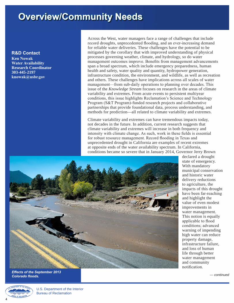
Effects of the September 2013 Colorado floods.
R&D Contact Ken Nowak Water Availability Research Coordinator 303-445-2197 [email protected]
Across the West, water managers face a range of challenges that includerecord droughts, unprecedented flooding, and an ever-increasing demand for reliable water deliveries. These challenges have the potential to be mitigated by the corollary that with improved understanding of physical processes governing weather, climate, and hydrology, so do watermanagement outcomes improve. Benefits from management advancements span a broad spectrum, which include emergency preparedness, human health and safety, water quality and quantity, hydropower generation, infrastructure condition, the environment, and wildlife, as well as recreation and others. These challenges have implications across all scales of watermanagement—from sub-daily operations to planning over decades. This issue of the Knowledge Stream focuses on research in the areas of climate variability and extremes. From acute events to persistent multiyearconditions, this issue highlights Reclamation’s Science and TechnologyProgram (S&T Program)-funded research projects and collaborative partnerships that provide foundational data, process understanding, and methods for prediction—all related to climate variability and extremes.
Climate variability and extremes can have tremendous impacts today, not decades in the future. In addition, current research suggests that climate variability and extremes will increase in both frequency andintensity with climate change. As such, work in these fields is essentialfor robust resource management. Record flooding in Texas and unprecedented drought in California are examples of recent extremes at opposite ends of the water availability spectrum. In California, conditions became so severe that in January 2014, Governor Jerry Brown
declared a drought state of emergency. With mandatory municipal conservation and historic water delivery reductions to agriculture, the impacts of this droughthave been far-reaching and highlight the value of even modest improvements in water management. This notion is equallyapplicable to floodconditions; advancedwarning of impending high water can reduce property damage, infrastructure failure, and loss of human life through better water management and communitynotification.
— continued
U.S. Department of the Interior Bureau of Reclamation
4
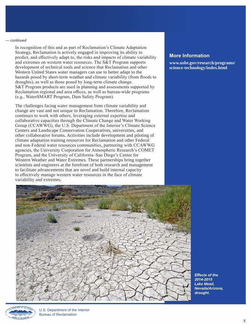
Effects of the 2014-2015 Lake Mead, Nevada/Arizona, drought.
— continued
In recognition of this and as part of Reclamation’s Climate Adaptation Strategy, Reclamation is actively engaged in improving its ability topredict, and effectively adapt to, the risks and impacts of climate variabilityand extremes on western water resources. The S&T Program supports development of technical tools and science that Reclamation and other Western United States water managers can use to better adapt to thehazards posed by short-term weather and climate variability (from floods todroughts), as well as those posed by long-term climate change.S&T Program products are used in planning and assessments supported byReclamation regional and area offices, as well as bureau-wide programs(e.g., WaterSMART Program, Dam Safety Program).
The challenges facing water management from climate variability and change are vast and not unique to Reclamation. Therefore, Reclamationcontinues to work with others, leveraging external expertise andcollaborative capacities through the Climate Change and Water WorkingGroup (CCAWWG), the U.S. Department of the Interior’s Climate Science Centers and Landscape Conservation Cooperatives, universities, and other collaborative forums. Activities include development and piloting of climate adaptation training resources for Reclamation and other Federaland non-Federal water resources communities, partnering with CCAWWGagencies, the University Corporation for Atmospheric Research’s COMETProgram, and the University of California–San Diego’s Center for Western Weather and Water Extremes. These partnerships bring together scientists and engineers at the forefront of both research and management to facilitate advancements that are novel and build internal capacityto effectively manage western water resources in the face of climate variability and extremes.
More Information www.usbr.gov/research/programs/ science-technology/index.html
U.S. Department of the Interior Bureau of Reclamation
5

Reservoir operations pilot studies are critical to understand where flexibilities in reservoir operations may be increased through identifying trends in historic and current climate, hydrology, and through improved use of weather forecasting
Innovative developments are being pursued to provide guidance to adapt reservoir operations in the long term to climate change.
Contact Katharine Dahm Civil EngineerWater Resources and Planning DivisionPolicy and Administration Office 303-445-2495 [email protected]
Locations of the five reservoir operationspilot studies initiatedin 2015.
Operating for the Long Run: Pilot Studies of Reservoir Operations to Respond to ClimateChange and Other Future Challenges Reclamation seeks additional water management flexibility to address the increasing challenges in the next century—and well beyond. To help ensure effective future operations, Reclamation’s Climate Change Adaptation Strategy identifies improving reservoir operations as a high priority. In 2014, Reclamation launched the Reservoir Operations Pilot Initiative to determinehow reservoir operations could be impacted by climate change and howreservoir operations can be made more flexible to adapt to impacts.
Reclamation’s reservoirs are operated using criteria to meet a number ofdifferent water management priorities. Historically, uncertainties in weather prediction and assumptions of an unchanging climate have resulted in seasonalto annual operating criteria for reservoir management. It is expected that insome locations these criteria will have to be updated to consider future climateconditions to maintain the flexibility required to meet the operating criteria.
Reclamation established a Reclamation-wide group of regional reservoiroperations experts, planners, climate scientists, and hydrologists to undertakethe pilot initiative and develop guidance to increase reservoir operationsflexibility as an adaptation strategy to climate change impacts. As climate
change alters hydrologic regimes, reservoiroperations may need to be adjusted to maintainreliable water deliveries and power generation,support environmental needs, and manage floodcontrol.
In 2015, Reclamation initiated five reservoir operations pilot studies to evaluate howimproved scientific information on weather, hydrology, sedimentation, groundwater interactions, and climate change informationcould better inform reservoir operations in fiveReclamation regions:
• Great Plains: Upper Washita, Fort Cobb, and Foss Reservoirs
• Mid-Pacific: Klamath River Basin, Klamath Project
• Pacific Northwest: Ochoco Creek and Crooked River
• Upper Colorado: Upper Colorado RiverDrought Contingency Plan, Climate andOperations Assessment Methodology
• Lower Colorado: Salt River Project, Salt and Verde Rivers
— continued
U.S. Department of the Interior Bureau of Reclamation
6
— continued
These pilot studies are critical to understanding where flexibilities in reservoiroperations may be increased through identifying trends in historic andprojected climate, hydrology, sedimentation, and conjunctive groundwater management. Multiple pilot demonstrations at different sites are needed tofully vet approaches to incorporating future climate information into reservoiroperations. Work began on the reservoir operations pilot studies in January 2016 and will continue through December 2017. A few of the key aspects of each pilot study are:
• Using observations and projections to identify risks to operations
• Evaluating the operating thresholds of the system
• Understanding opportunities to improve reservoir operations flexibilityby leveraging advanced streamflow forecasting research supported by theResearch and Development Office (R&D) (see article on page 10)
• Developing alternatives to increase operational flexibility and addresiliency to respond to future conditions
Guidance will include conceptualapproaches for considering climatechange within reservoir operationsand identifying the statistical tools andmodels necessary to implement thoseconceptual approaches. Moreover, guidance will specifically discuss thepilot studies as case studies to considerclimate change information in futurereservoir operations planning. Thus, this guidance will ensure that allReclamation reservoirs can benefit from the wealth of Reclamation’s experience as well as lessons learnedin these pilot studies.
This activity is closely coordinated with ongoing activities inReclamation’s R&D, Dam Safety Office, and Technical Service Center as well as through external coordinationwith the National Oceanic and Atmospheric Administration and the U.S. Army Corps of Engineers.
More Information Reclamation’s Climate Change Adaptation Strategy:
www.usbr.gov/climate/docs/ ClimateChangeAdaptationStrategy. pdf
Reservoir Operations Pilot Initiative website: www.usbr.gov/watersmart/wcra/ reservoirpilot.html
The Reservoir Operations Pilot Initiative is funded through Reclamation’s WaterSMART Basin Studies Program under the West-Wide Climate Risk Assessments (WWCRA): www.usbr.gov/watersmart/wcra/ index.html
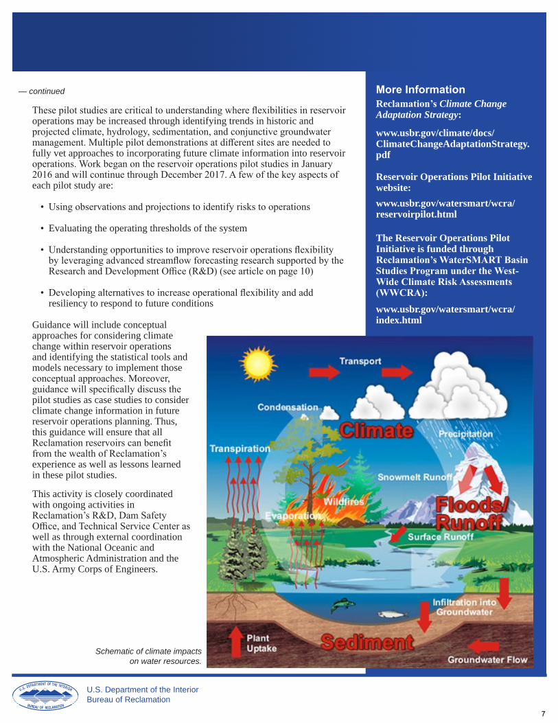
Schematic of climate impacts on water resources.
U.S. Department of the Interior Bureau of Reclamation
7

Collaborators • Reclamation • National Oceanic and Atmospheric
Administration • University of Colorado–Boulder’s
Cooperative Institute for Research and Environmental Studies • National Center for Atmospheric
Research
Contacts Kelly Mahoney Research Scientist Physical Sciences Division Earth Systems Research Laboratory National Oceanic and Atmospheric Administration 303-497-5616 [email protected]
Katie Holman MeteorologistFlood Hydrology and Meteorology Group Technical Service Center Bureau of Reclamation 303-445-2571 [email protected]
R&D Contact Ken Nowak Water Availability Research Coordinator 303-445-2197 [email protected]
Figure 1.—Taylor Park Dam watershed in west-
central Colorado.
Estimating Extreme Precipitation Using High-ResolutionWeather Models One of the greatest challenges in support of water management and planning is estimating heavy precipitation events at remote, high-elevation locations acrossthe Western United States. Members of the Flood Hydrology and Meteorology Group in Reclamation’s Technical Service Center (TSC) use information on historical precipitation events, such as spatial patterns of precipitation totals,to better understand and estimate the flood response in watersheds withReclamation facilities under various hydrologic and meteorological conditions.Some of the methods used to estimate historical precipitation events (e.g.,maximizing precipitation totals and artificially moving historical precipitationevents) are outdated but are still used as they utilize existing infrastructure andprovide timely results.
Understanding the need for improved techniques, Reclamation partnered with the National Oceanic and Atmospheric Administration (NOAA), the University of Colorado–Boulder’s Cooperative Institute for Research and Environmental Studies (CIRES), and the National Center for Atmospheric Research (NCAR) on this cooperative agreement research project to develop improved methods forestimating extreme precipitation events and associated runoff at high-elevationlocations relevant to Reclamation. Together, these four agencies set out to answer the following questions for a test watershed in Colorado, the Taylor Park Dam watershed (figure 1):
• Can high-resolution weather models realistically capture small-scale processes that generate extreme precipitation events?
•Can multiple simulations of individual precipitation events help the team understand uncertainty surrounding historical events?
•Are there benefits of using ahigh-resolutionnumerical weather model combined with a rainfall-runoff model in dam safetydecisionmaking?
The Taylor Park Damwatershed is a remote watershed located in west-central Colorado at an elevation ranging from 9,300 to13,000 feet above sea level. Taylor Park Dam, which
— continued
U.S. Department of the Interior Bureau of Reclamation
8
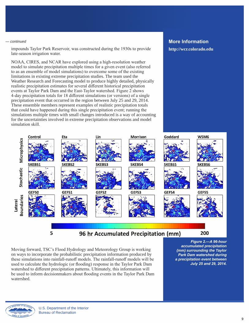
— continued More Information impounds Taylor Park Reservoir, was constructed during the 1930s to provide late-season irrigation water.
http://wcr.colorado.edu
NOAA, CIRES, and NCAR have explored using a high-resolution weathermodel to simulate precipitation multiple times for a given event (also referredto as an ensemble of model simulations) to overcome some of the existinglimitations in existing extreme precipitation studies. The team used the Weather Research and Forecasting model to produce highly detailed, physically realistic precipitation estimates for several different historical precipitationevents at Taylor Park Dam and the East-Taylor watershed. Figure 2 shows 4-day precipitation totals for 18 different simulations (or versions) of a singleprecipitation event that occurred in the region between July 25 and 29, 2014.These ensemble members represent examples of realistic precipitation totalsthat could have happened during this single precipitation event; running thesimulations multiple times with small changes introduced is a way of accountingfor the uncertainties involved in extreme precipitation observations and modelsimulation skill.
Moving forward, TSC’s Flood Hydrology and Meteorology Group is working on ways to incorporate the probabilistic precipitation information produced bythese simulations into rainfall-runoff models. The rainfall-runoff models will be used to calculate the hydrologic (or flooding) response in the Taylor Park Dam watershed to different precipitation patterns. Ultimately, this information will be used to inform decisionmakers about flooding events in the Taylor Park Dam watershed.
Figure 2.—A 96-hour accumulated precipitation
(mm) surrounding the Taylor Park Dam watershed during
a precipitation event between July 25 and 29, 2014.
U.S. Department of the Interior Bureau of Reclamation
9
R&D Contact Ken Nowak Water Availability Research Coordinator 303-445-2197 [email protected]
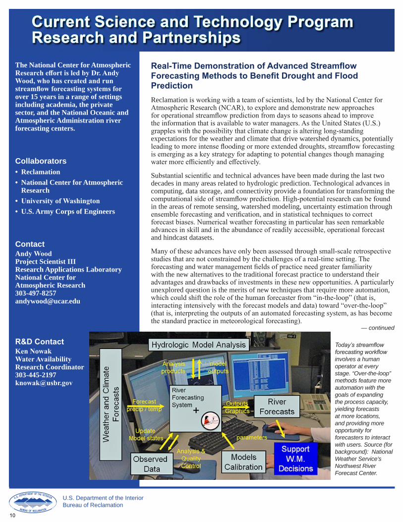
Today’s streamflow forecasting workflow involves a human operator at every stage. “Over-the-loop” methods feature more automation with the goals of expanding the process capacity, yielding forecasts at more locations, and providing more opportunity for forecasters to interact with users. Source (for background): National Weather Service’s Northwest River Forecast Center.
The National Center for Atmospheric Research effort is led by Dr. Andy Wood, who has created and run streamflow forecasting systems forover 15 years in a range of settings including academia, the private sector, and the National Oceanic and Atmospheric Administration river forecasting centers.
Collaborators •Reclamation •National Center for Atmospheric
Research • University of Washington •U.S. Army Corps of Engineers
Contact Andy WoodProject Scientist III Research Applications Laboratory National Center for Atmospheric Research 303-497-8257 [email protected]
Real-Time Demonstration of Advanced Streamflow Forecasting Methods to Benefit Drought and FloodPrediction Reclamation is working with a team of scientists, led by the National Center forAtmospheric Research (NCAR), to explore and demonstrate new approachesfor operational streamflow prediction from days to seasons ahead to improvethe information that is available to water managers. As the United States (U.S.) grapples with the possibility that climate change is altering long-standingexpectations for the weather and climate that drive watershed dynamics, potentiallyleading to more intense flooding or more extended droughts, streamflow forecastingis emerging as a key strategy for adapting to potential changes though managing water more efficiently and effectively.
Substantial scientific and technical advances have been made during the last twodecades in many areas related to hydrologic prediction. Technological advances in computing, data storage, and connectivity provide a foundation for transforming the computational side of streamflow prediction. High-potential research can be foundin the areas of remote sensing, watershed modeling, uncertainty estimation throughensemble forecasting and verification, and in statistical techniques to correctforecast biases. Numerical weather forecasting in particular has seen remarkableadvances in skill and in the abundance of readily accessible, operational forecastand hindcast datasets.
Many of these advances have only been assessed through small-scale retrospectivestudies that are not constrained by the challenges of a real-time setting. The forecasting and water management fields of practice need greater familiaritywith the new alternatives to the traditional forecast practice to understand theiradvantages and drawbacks of investments in these new opportunities. A particularly unexplored question is the merits of new techniques that require more automation,which could shift the role of the human forecaster from “in-the-loop” (that is,interacting intensively with the forecast models and data) toward “over-the-loop” (that is, interpreting the outputs of an automated forecasting system, as has becomethe standard practice in meteorological forecasting).
— continued
U.S. Department of the Interior Bureau of Reclamation
10
— continued
To provide insights in these areas, the NCAR-led effort is creating a testbed for assessing alterative, new elements in the streamflow forecast workflow. These include a range of hydrologic models, numerical weather and climate predictiondatasets, model implementation techniques (e.g., parameter estimation), andstatistical methods that add skill to the forecast process (termed forecastdownscaling and post-processing). The testbed, System for Hydromet Research and Prediction Applications (SHERPA), focuses on several dozen forecasting watersheds around the U.S. that have been selected for their importance to watermanagement. It is being constructed to provide not only real-time forecasts, butalso retrospective hindcasts that are a critical resource to interpreting the skill andpotential benefit of the new forecasts for water management.
To date, this research project has created real-time and hindcast water supplypredictions for a number of catchments, including reservoir inflows forseveral projects managed by Reclamation. These predictions demonstrate a range of strategies for incorporating information into traditional approachesthat use only watershed information, such as measurements or simulations ofsnow water equivalent. Researchers are finding that increases in skill can beachieved, particularly at longer lead times when watershed moisture does notprovide a strong indication of the future seasonal runoff. The best techniques involve a hybrid of dynamical approaches (that is, simulation and forecastingwith watershed models) and statistical methods that merge in predictions based on climate system states (such as sea surface temperatures) and indices(such as El Niño Southern Oscillation indicators like the Nino3.4 index). The implementation of the short-to-medium range forecasts is still in progress.
“We have entered a period of transformation in streamflow forecasting and water management, in which traditional approaches will greatly expand to incorporate new technological and scientific resources. It is an exciting time, but there is a great need to understand the benefits and tradeoffs of the new opportunities so that we can best use them to adapt to changes in climate, water demands, and risks.” Dr. Andy Wood Project Scientist III National Center for Atmospheric Research
More Information Refer to Reclamation’s Science and Technology Program Research Project, “Over-the-Loop Streamflow Forecasting,” Project ID 0010.
NCAR’s SHERPA: www.ral.ucar.edu/projects/sherpa/
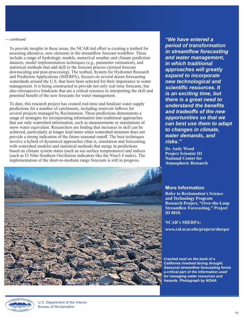
Cracked mud on the bank of a California riverbed during drought. Seasonal streamflow forecasting forms a critical part of the information used for managing water resources and hazards. Photograph by NOAA.
U.S. Department of the Interior Bureau of Reclamation
11

Collaborators • Reclamation • University of California–SanDiego’s Center for Western Weather and Water Extremes
Contacts Marty RalphDirector, Center for Western Weather and Water Extremes Scripps Institution of Oceanography University of California–San Diego 858-822-1809 [email protected]
Alexander (Sasha) GershunovResearch Meteorologist Climate Atmospheric Science and Physical Oceanography Scripps Institution of Oceanography University of California–San Diego 858-534-8418 [email protected]
R&D Contact Ken Nowak Water Availability Research Coordinator 303-445-2197 [email protected]
Development of Subseasonal-to-Seasonal Outlooksfor West Coast Atmospheric Rivers In collaboration with the Center for Western Weather and Water Extremes (CW3E), housed at the University of California–San Diego’s Scripps Institution of Oceanography (SIO), Reclamation is working with a team of scientists on anovel method for detecting atmospheric rivers (ARs) and to create a catalog ofpast ARs spanning almost seven decades. Using this catalog, the team will study AR behavior and how it relates to climate variability. The goal is to develop a methodology that will help researchers predict landfalling AR activity (i.e., precipitation) a couple of weeks to a season or so ahead of the wet season(i.e., October to April).
ARs are relatively narrow, long ribbons of enhanced water vapor that transport much of the moisture from the humid tropics and subtropics to polar latitudes.When they make landfall, they can dump heavy amounts of precipitation,particularly where mountain chains intersect their path. North America’s west coast, with its coastal and inland mountain ranges facing the Pacific, the broadestocean on earth, is a prime recipient of AR-generated rain and snow.
Because ARs provide a great part of total precipitation to the West, they are vital drivers of western water resources. Extreme ARs are associated with many of the region’s floods, while lulls in their activity are associated with droughts. Clearly, being able to predict the subseasonal-to-seasonal behavior of ARs would greatly improve the ability to manage water resources in the West, as well as help improve emergency preparedness.
The information necessary to develop subseasonal-to-seasonal AR outlooks includes a long record of landfalling AR activity over decades. This includes more than just landfall counts, but data on their location, intensity, direction, and duration—tracking lifecycles of many individual AR events resolved at sub-daily timescales cataloged over decades. Based on such records, researcherscan begin to understand the links between AR activity and modes of climate variability that may be predictable—links that can then form a basis forsubseasonal-to-seasonal outlooks. — continued
Satallite water vaporimage indicating a thin
ribbon of enhanced moisture—an AR heading
from the tropics to thePacific Northwest coast of
the United States.
U.S. Department of the Interior Bureau of Reclamation
12

— continued
Through the collaboration, researchers have developed an automated method to detect ARs and applied it to a dataset that joins historical weather simulations and observations to create a catalog of landfalling ARs spanning 67 years (from 1948 to 2015). They validated the new catalog with an existing satellite-based catalog, as well as with long-term precipitation observations.
The new catalog provides a detailed record of AR activity affecting the West that researchers are data mining to describe the seasonal progression ofAR landfalls from the Gulf of Alaska coastline in late summer-early fall to California by the late fall-early winter. They have also diagnosed connections between seasonal AR activity and climate variability expressed in Pacific sea surface temperatures, revealing connections to Pacific decadal variability, recent regional anomalies including unusually warm coastal waters, and long-term ocean warming.
This catalog also provides new opportunities to study climate-scaleAR behavior and its links to regional and global climate variability inunprecedented detail. The team is working to systematically understand and use these connections to develop subseasonal-to-seasonal AR outlook methodologies to follow.
More Information Refer to Reclamation’s Science and Technology Program Research Project, “Seasonal and Extended-Range Predictability of Atmospheric Rivers and Their Associated Precipitation,” Project ID 1501.
Center for Western Weather and Water Extremes:
http://cw3e.ucsd.edu
Average percent of total seasonal precipitation contributed by ARs. Seasons are abbreviated as follows: JAS—June through September; OND—October through December; JFM—January through March; and AMJ—April through June. Image created by, and courtesy of, Tamara Shulgina, CW3E/SIO.
U.S. Department of the Interior Bureau of Reclamation
13
The National Center for Atmospheric Research effort is led by Martyn Clark, who has more than 20 years of experience in research on climate and water.
Collaborators • Reclamation• National Center for Atmospheric
Research• University of Washington• U.S. Geological Survey• U.S. Army Corps of Engineers
Contact Martyn ClarkScientist III Research Applications Laboratory National Center for Atmospheric Research 303-497-2732 [email protected]
R&D Contact Ken Nowak Water Availability Research Coordinator 303-445-2197 [email protected]
More Information Clark, M.P., R.L. Wilby, E. Gutmann, J.A. Vano, S. Gangopadhyay, A. Wood, H. Fowler, C. Prudhomme, J. Arnold, and L. Brekke. 2016. “Characterizing Uncertainty ofthe Hydrologic Impacts of Climate Change.” Climate Change Reports (in press).
Improving Methods for Estimating Future Climateand Hydrology Conditions Under Climate Change Reclamation is working with a team of scientists, led by the National Center for Atmospheric Research (NCAR), to better characterize the impacts of climate change on water resources. This work focuses on defining a range of different scenarios (quantitative hydrologic storylines), depicting possible changes in future climate and hydrology. Such quantitative hydrologic storylines are critical in order to evaluate the vulnerability of infrastructure systems and the effectiveness of different adaptation strategies in managing climate-related stresses.
Developing quantitative hydrologic storylines of future change for the water sector is an interdisciplinary endeavor—it entails representing currentknowledge of global change in the context of substantial uncertainty inthe trajectory of future climate and the associated impacts on hydrologicprocesses. Recent research (Clark et al., 2016) has shown the importance of assessing uncertainty from a large number of sources including:
• Climate forcings (e.g., emissions scenarios)
• Models used for global climate simulation
• Chaotic internal variability in the climate system
• Development of climate projection information at scales finer than theglobal climate model simulation scales (i.e., climate downscaling)
• Choice, configuration, and calibration of hydrologic models
The uncertainties from all these sources aggregate to the overall uncertainty in characterizing climate impacts, focusing research to create quantitativehydrologic storylines that reflect these myriad uncertainties.
This research project follows the approach illustrated in the figure. In thisfigure, the first two columns illustrate ongoing work to characterize the uncertainties in the current best practice methods. The next column illustrates work designed to reduce this uncertainty through improved sampling strategies, and improved modeling and parameter estimation techniques.The final column illustrates the construction of hydrologic storylines. These storylines are designed to represent the uncertainty represented in a very large ensemble of methods in a smaller number of carefully selected ensemble members.
In constructing quantitative hydrologic storylines, this research projecthas contributed two major scientific advances. The first advance is the development of the Intermediate Complexity Atmospheric Research (ICAR) model, designed to both improve the fidelity of climate downscalingmethods and better characterize uncertainty in climate downscaling. The second advance is the development of the Structure for Unifying Multiple
— continued
U.S. Department of the Interior Bureau of Reclamation
14

— continued
Modeling alternatives (SUMMA), a hydrologic modeling framework,which is designed to improve the fidelity of hydrologic models and bettercharacterize model uncertainty.
“We have identified important uncertainties that
Schematic of the approach to characterize and reduce the uncertainties in assessments of the hydrologic impacts of climate change, and the development of representative quantitative hydrologic storylines for specific applications (the “Y” axis equals Probability Density Function). Source: Clark et al., 2016.
“We have identified important uncertainties that have hither to been neglected by the water resources community in their climate impact assessments, and advanced a more deliberate approach to assessing hydrologic uncertainty under climate change. This research produces quantitative hydrologic storylines of climate change impacts to support water resources planning and management.” Martyn ClarkScientist III National Center for Atmospheric Research
U.S. Department of the Interior Bureau of Reclamation
15

A simulation of the extreme rain event that occurred June 2 through 4, 2010, over a portion of the Snake River
Basin, Idaho. The area encapsulated by the white wire frame reflects the region used as a case study as part of
this research project. Source: 3-D visualization by
Collaborators • Reclamation’s Pacific Northwest
Region • Boise State University, Idaho • U.S. Department of Agriculture’s
Agricultural Research Service
Contacts Eric Rothwell HydrologistColumbia-Snake Salmon Recovery OfficePacific Northwest RegionBureau of Reclamation 208-378-5370 [email protected]
Alejandro N. Flores, Ph.D. Associate Professor Department of Geosciences Boise State University, Idaho 208-426-2903 [email protected]
R&D Contact Ken Nowak Water Availability Research Coordinator 303-445-2197 [email protected]
More Information www.usbr.gov/research/projects/ detail.cfm?id=9682
Improving Regional Weather Forecasts to Support Reservoir Operations In the Western United States, water resources infrastructure is designed to buffervariability in precipitation and snow storage, deliver reliable water supply to users,afford flood control for communities, and provide recreation opportunities to thepublic. Operation of water resources infrastructure depends on reservoir inflowand weather forecasts. Weather forecasts are often limited in spatial resolution and leadtime. For instance, the National Weather Service’s National Centers for Environmental Prediction Global Forecast System (GFS) predicts weather for thenext 8 days at a spatial resolution of roughly 30 miles. This resolution is too coarse to represent the influence of mountainous terrain on weather patterns, which limits the usefulness of these weather forecasts in subsequent streamflowforecasting. In addition,the 8-day maximumleadtime of GFS productsmeans that resource managers have littlequantitative informationto provide guidancebeyond about a week.
In response to theseneeds, Reclamation’s Pacific Northwest Region; Boise StateUniversity, Idaho; the U.S. Department ofAgriculture’s Agricultural Research Service (ARS);and water stakeholders in the southern Idaho region are partnering onthis Reclamation Science and Technology Program research project to:
• Develop and test more regionalized approaches to weather forecasting toimprove accuracy, extend leadtimes, and increase spatial resolution relative to available products
• Develop techniques to rapidly and effectively communicate important forecastproducts and guidance to water managers.
Water stakeholders are playing an important role in the effort, informing researchers’ approaches to weather and water models configurations, as well as the presentation and communication of results and data products. This work leverages Reclamation and ARS collaboration on methods to improve snowpack monitoring and snowmelt prediction for the benefit of short-term water supply forecasting andreservoir operations.1
1 www.usbr.gov/research/projects/detail.cfm?id=2264
NCAR’s VAPOR software.
U.S. Department of the Interior Bureau of Reclamation
16

New, Higher Resolution Climate Observations and Model Projections From Mexico Through SouthernCanada Better estimates of the impacts of climate change require that observations and the latest global climate simulations be represented with higher spatial resolution,more realistic extremes, over a larger domain, and with more consistency across international boundaries (i.e., downscaled).
To this end, a new dataset of gridded daily precipitation, maximum and minimum temperature with 1/16-degree (~6 kilometer) resolution was developed usinghistorical weather records. The domain spans Mexico through the conterminous United States and into Canada south of 53° N., covering 1950 to 2013 (Livnehet al., 2015). The dataset improves upon previous products in spatial extent, continuity across boundaries, and estimates of precipitation in mountainousregions. Hydrological variables (soil moisture, snowpack, etc.) were simulatedusing the Variable Infiltration Capacity (VIC) model. This dataset is suitable for water balance studies, forcing land surface models, and downscaling.
The gridded data were used as the basis for a new downscaling method for global climate models—localized constructed analogs (LOCA) (Pierce et al., 2014).LOCA attempts to preserve daily temperature and precipitation extremes better than previous similar downscaling methods. Additionally, the downscaled fields have more realistic spatial coherence (important for flooding) and preserve theoriginal global model-predicted trends. The downscaled data are available on the 1/16-degree grid for 32 global climate models from the Coupled ModelIntercomparison Project Phase 5, covering 1950 to 2100 with two future scenarios(Representative Concentration Pathways 4.5 and 8.5). LOCA was supported by the California Energy Commission, U.S. Army Corps of Engineers, U.S. Geological Survey through the Southwest Climate Science Center, and the National Aeronautics and Space Administration (NASA) via the NASA Earth Exchange and NASA Advanced Supercomputing Facility. The data will soon be available from the Lawrence Livermore National Laboratory’s Green Data Oasis website at: http://gdo-dcp.ucllnl.org/downscaled_cmip_projections/dcpInterface.html.
Example of LOCA downscaled data showing the multimodel ensemble average daily maximum temperature in summer (June, July, and August [JJA]) from 32 global climate models.
Collaborators • Reclamation • University of California–San Diego • University of Colorado–Boulder
Contacts Ben Livneh, Ph.D. Assistant Professor Department of Civil, Environmental, and Architectural Engineering University of Colorado–Boulder 303-735-0288 [email protected]
David W. Pierce Climate Atmospheric Science and Physical Oceanography Scripps Institution of Oceanography University of California–San Diego 858-534-8276 [email protected]
R&D Contact Ken Nowak Water Availability Research Coordinator 303-445-2197 [email protected]
More Information http://wcr.colorado.edu
Livneh, B., T.J. Bohn, D.W. Pierce, F. Munoz-Arriola, B. Nijssen, R. Vose, D.R. Cayan, and L. Brekke. 2015. “A spatially comprehensive, hydrometeorological data set for Mexico, the U.S., and Southern Canada 1950–2013.” Scientific Data, 2: 150042. DOI:10.1038/sdata.2015.42
Pierce, D.W., D.R. Cayan, and B.L. Thrasher. 2014. “Statistical Downscaling Using LocalizedConstructed Analogs (LOCA).” Journal of Hydrometeorology, 15, 2558-2585.
U.S. Department of the Interior Bureau of Reclamation
17

Assessing Groundwater Recharge as the ClimateChanges The importance of groundwater is increasing as the climate changes across the semiarid regions of the Western United States (U.S.) and recognition of groundwater and surface water as a single resource to meet water demandsis growing. Fundamental to using groundwater is an understanding of theavailability of the resource that has a complex space-time distribution.Characterization of its availability is challenging given the uncertainties arisingfrom the geology to the limited number of water level measurements. Evenwith the realities of these prevailing uncertainties, it is essential to developan understanding of the space-time distribution of available groundwaterresources and its broader connection to large-scale climate. Groundwater levels, storage, and flow can span time scales ranging up to millennia or even longer. The practical time scale of importance for water resources management is anunderstanding of groundwater variability at the interdecadal time scale and in thenear surface (upper 1,000 feet).
The predominant natural driver for replenishment in relatively shallow near-surface groundwater systems is groundwater recharge. These shallow groundwater systems across the semiarid regionsof the Western U.S. are generally replenished through large but infrequent groundwater recharge events. Reclamation has been collaborating withthe U.S. Geological Survey on this ReclamationScience and Technology Program research project to understand the characteristics of large recharge events. Specifically:
•What are the antecedent conditions, and climatic conditions that constitute a large recharge event, and how such events may be classified using time series of water levelmeasurements?
•How much does groundwater storage changewith large recharge events, and what are the implications for groundwater availability andmanagement and connected streamflow shouldthe magnitude and frequency of large recharge events change?
These questions are being explored through a case study application in the northern Great Basin. Using multivariate time series analysis of observedgroundwater level data, large groundwater recharge events were estimated to have historically occurred with a frequency of about 11 to 13 years, and numerical groundwater modeling of historical events in the northern Great Basin show thatthese events could result in millions of acre-feet of groundwater recharge and storage. As groundwater use is anticipated to increase with decreasing surface water supplies under climate change, an understanding of mechanisms drivingrecharge events and impacts to groundwater systems is essential for developing robust water management adaptation strategies. This need is also supported by the recognition that as groundwater use increases, groundwater contributions tostreamflow will decline, thereby further reducing surface water supplies.
Collaborators • Reclamation • U.S. Geological Survey
Contact Subhrendu Gangopadhyay Supervisory Civil EngineerWater Resources Planning and Operations Support Group Technical Service Center Bureau of Reclamation 303-445-2465 [email protected]
Schematic representation of groundwater modeling. R&D Contact
Ken Nowak Water Availability Research Coordinator 303-445-2197 [email protected]
More Information www.usbr.gov/research/projects/ detail.cfm?id=5424
U.S. Department of the Interior Bureau of Reclamation
18

Flood Frequency Variability on Seasonal to Multidecadal Time Scales in the Western United States and Implications for Infrastructure Planning In the semiarid Western United States (U.S.), water resources infrastructure such as dams, levies, and canals provide a reliable water supply, flood mitigation, andhydropower generation. The ability to manage these aging infrastructures efficientlyfor hydroclimate extremes such as floods, in a nonstationary climate, is crucial for thesustainability of the region. Traditional methods for analyzing hydroclimate extremesassume stationarity of climate in space and time and do not capture uncertainty in arobust manner, leading to inaccurate estimation and misrepresentation of risk.
This Reclamation Science and Technology Program research project is motivated by the need for a mechanistic understanding of hydroclimate extremes and a generalframework to model them across the entire Western U.S., while maintaining a robustquantification of uncertainty. University of Colorado researchers:
1.Identified eight seasonally dependent and spatially coherent regions for precipitation extremes in the Western U.S. and the dominant moisture sources anddelivery pathways for each region. Extreme value clustering and storm trajectoryanalysis were used in this effort.
2.Developed a Bayesian hierarchical spatial model for precipitation extremes inlarge regions, such as the Western U.S., incorporating data from thousands ofobservation locations. This model can produce maps of gridded return levelsand simulate gridded precipitation extremes at any resolution, with associateduncertainties.
3.Developed a Bayesian hierarchical model for joint nonstationary precipitationand streamflow frequency analysis in rainfall-runoff dominated basins, such asthose in the Southwest U.S. Peak streamflow is modeled as a consequence ofspatial precipitation extremes, allowing for temporal nonstationarity from climatecovariates.
4.Developed a general Bayesian hierarchical multivariate nonstationary frequencyanalysis framework with an application to dam safety analysis. In this, thepeak snow depth and peak streamflow are linked to reservoir water level and,consequently, dam safety.
Collaborators • Reclamation • University of Colorado
Contacts Subhrendu Gangopadhyay Supervisory Civil EngineerWater Resources Planning and Operations Support Group Technical Service Center Bureau of Reclamation 303-445-2465 [email protected]
Cameron Bracken Civil EngineerWater Resources Planning and Operations Support Group Technical Service Center Bureau of Reclamation 303-445-2792 [email protected]
R&D Contact Ken Nowak Water Availability Research Coordinator 303-445-2197 [email protected]
These contributions provide new insights into the mechanisms influencinghydroclimate extremes in the Western U.S. and offer new frameworks for spatial,nonstationary, and multivariate modeling of extremes with an emphasis on therobust quantification of uncertainties. These contributions have direct applicabilityto Reclamation’s planning, risk assessment, and mitigation strategies for managinginfrastructure under changing climate hazards.
Extreme precipitation regions across the Western U.S.
More Information www.usbr.gov/research/projects/ detail.cfm?id=1916
U.S. Department of the Interior Bureau of Reclamation
19

The following list of Research Updates (Bulletins) showcase completed research within Reclamation’s Science and Technology Program. This list of Bulletins relates to this issue’s theme of addressing climate variability and extremes in water management. Please contact the authors/principal investigators for more information about these final research projects.
Determining How Runoff and Temperature Changes Are Linked to Fish Habitat Evaluating climate-induced runoff and temperature change on stream habitat metrics for endangered or threatened fish
“The models will help Reclamation and its partners analyze how future climatemay affect river rehabilitation projects to improve conditions for listed salmonidswith consideration for habitat response to climate change.”
Jennifer Bountry, Hydraulic EngineerReclamation’s Technical Service Center www.usbr.gov/research/docs/updates/2014-03-fish-habitat.pdf
Choosing the Right Meteorological Dataset for Hydrologic Simulations How meteorological datasets affect model simulations and portrayal of climate sensitivity
“This work supports previous findings, demonstrating that we need to considermany facets of datasets and ways to analyze them, as all of these factors play arole in how climate change impacts are portrayed in long-term natural resourcesplanning studies.”
Marketa Elsner, Hydrologic Civil EngineerReclamation’s Technical Service Center www.usbr.gov/research/docs/updates/2014-20-dataset.pdf
Improving Water Management With a State-of-the-Art Snow Model A physically based, high resolution snow model for enhanced streamflow predictions in a changing environment
“We have already been able to use model results to support real-time operations for the Boise River Basin. The graphics and numerical products depicting distribution and amount of available snowmelt water were very useful in confirming oursuspicions that runoff in both 2013 and 2014 would be less than forecasted, andless than what SNOTEL data alone would indicate.”
Mary Mellema, HydrologistReclamation’s Pacific Northwest Region
www.usbr.gov/research/docs/updates/2014-21-snow-model.pdf
— continued
U.S. Department of the Interior Bureau of Reclamation
20

— continued
Forecasting Extreme Flooding Events Understanding the causes of extreme floods to predict floods in a season and through many decades
“Understanding the dynamics behind extreme flood events will helpReclamation answer questions such as: Will floods become more severe and threaten flood infrastructure under climate change? Is Reclamation’s infrastructure adequately designed to perform under any increased risk due toclimate change?”
Subhrendu Gangopadhyay, Supervisory Civil Engineer Reclamation’s Technical Service Center
www.usbr.gov/research/docs/updates/2016-02-forecasting.pdf
Making It Easier to Talk About Climate Change Determining the need for clear explanations of concepts in analyzing climate information
“When working with stakeholders, we have found that clearly communicatingthe analysis and research is critical to avoid conflicts and come to agreements.Clear and thoughtful understanding of these complex issues allows stakeholdersto go back to their principals and convey this information accurately. This helps decisionmakers in their processes, as they are typically not climate changeexperts.”
Jim Prairie, Hydrologic EngineerReclamation’s Upper Colorado Region
www.usbr.gov/research/docs/updates/2016-09-climatechange-talk.pdf
U.S. Department of the Interior Bureau of Reclamation
21

Shasta Dam on the Sacramento River in northern California.
Water Prize Competition Center Contacts Chuck HennigDeputy Chief of R&DPrize Competitions Coordinator303-445-2134 [email protected]
Connie Svoboda Ecosystem Restoration Theme Area Prize Competition PortfolioManagerReclamation’s Technical Service Center 303-445-2152 [email protected]
Bobbi Jo Merten Infrastructure Sustainability Theme Area Prize Competition PortfolioCo-ManagerReclamation’s Technical Service Center 303-445-2380 [email protected]
Jessica Torrey Infrastructure Sustainability Theme Area Prize Competition PortfolioCo-ManagerReclamation’s Technical Service Center 303-445-2376 [email protected]
Reclamation’s Water Prize Competition Center Update Reclamation’s Water Prize Competition Center launched two new prize competitions on March 31, 2016, and another is planned for this summer:
Downstream Fish Passage at Tall Dams Ecosystem Restoration Theme Area This spring, Reclamation collaborated with the U.S. Geological Survey (USGS),National Oceanic and Atmospheric Administration’s National Marine Fisheries Service (NMFS), U.S. Fish and Wildlife Service, and U.S. Army Corps of Engineers (USACE) to launch a prize competition seeking new ideas forsuccessful and cost-effective downstream passage of juvenile fish at tall (high-head) dams.
Anadromous fish, such as salmon and steelhead, are hatched in fresh water and migrate downstream to the ocean where they spend most of their lives before migrating upstream to their natal stream to spawn. Adult salmon swimming upstream to spawn can migrate hundreds of miles and may have to pass a number of natural barriers and manmade structures on their journey. Juvenile fish hatched in freshwater tributaries must pass these same obstacles on their way downstream to the ocean.
While downstream passage over high-head dams for some species and life history stages has been achieved to a limited degree, much improvement indownstream juvenile fish passage is still needed. Effective downstream passage,paired with effective upstream passage, would increase habitat availabilitythat many threatened and endangered fish populations need to rebuild resilient populations. With downstream passage ensured, large areas of habitat above previously impassable dams could become available for new fish production.
Forty-four proposed solutions were submitted by solvers before the prize competition closed on May 10, 2016. These proposed solutions will be evaluated by a panel of experts from Reclamation, USGS, NMFS, USACE, and the State of California Department of Water Resources. Winners will be announced by the end of July 2016.
Watch subject matter experts talk about downstream fish passage and this prize competition in this short video: www.youtube.com/watch?v=TzCTgG0zXKs.
U.S. Department of the Interior Bureau of Reclamation
22

Fontenelle Dam on the Green River in southwestern Wyoming, 1965. Partial failure caused by internal erosion.
An example of a breach in an earthen canal embankment resulting from
Detecting the Movement of Soils (Internal Erosion) Within Earthen Dams, Canals, Levees, and Their Foundations Infrastructure Sustainability Theme Area Also this spring, Reclamation collaborated with USACE to launch a prizecompetition seeking new methods for detecting soil movement (internal erosion) in earthen structures and foundations earlier than what is possible with current visual inspection and instrumentation methods. These methods may detect internal erosion either by detecting soil movement or the properties that typicallyindicate internal erosion is taking place.
Earthen dams, canals, and levees are prone to internal erosion caused by seepage. Seepage can cause soils to move either through or under the structures. The internal erosion process is largely invisible as it occurs below the ground surface. By the time visible signs are present, damage has likely occurred and the structure will probably need to be mitigated or repaired. If soil movement can be detected earlier, it could increase the time available to intervene and correct the problem, decreasing the extent and cost of repairs or, perhaps, avoiding damage altogether.
While there are a number of ways soils can move, they all share a common feature—the erosion results in the movement of soils from an initiation point to an exit point. The distance from the initiation point to the exit point can be as small as a few meters, or as large as hundreds of meters.
Twenty-nine proposed solutions were submitted by solvers before the prize competition closed on May 10, 2016. These proposed solutions will be evaluated by a panel of experts from Reclamation, USACE, and the State of Colorado DamSafety Office. Winners will be announced by the end of July 2016.
Watch subject matter experts talk about internal erosion and this prize competition in this short video: www.youtube.com/watch?v=b1j0_CyXoV8&feature=youtu.be
Up Next: Preventing Rodent Burrows in EarthenEmbankments Infrastructure Sustainability Theme Area This summer, Reclamation will collaborate with USACE, the State of Colorado Dam Safety Office, and various water irrigation districts that operate Federalirrigation projects and launch a prize competition seeking new cost-effectiveways to prevent rodents from burrowing into the earthen embankments of dams, canals, and levees.
These burrows are a prevalent and widespread problem. They can cause seepage paths in embankment systems, which can lead to structural failures that endanger downstream lives, property, and/or result in lost and interrupted water supplies. Many of the more traditional and “intuitive” methods have been tried withlittle success to date. The Water Prize Competition Center hopes the solver community can “dig deeper” than the rodents to find creative and effective solutions to this challenge.
More Information www.usbr.gov/research/challenges www.challenge.gov www.usbr.gov/newsroom/newsrelease/ detail.cfm?RecordID=53427
rodent activity.
U.S. Department of the Interior Bureau of Reclamation
23

U.S. Department of the Interior Bureau of Reclamation
Ken Nowak.
www.usbr.gov/research/about/ contact.html
Ken Nowak, Research and Development Office Water Availability Research Coordinator Ken Nowak recently joined the Research and Development Office (R&D) as the new Water Availability Research Coordinator. In this position, he supports various Reclamation Science and Technology Program (S&T Program) initiatives.
Ken began working on water issues of the Western United States while attending the University of Colorado. His master’s thesis focused on the Gunnison River Basin, in collaboration with Reclamation’s Upper Colorado Region. After receiving his Masters of Science in Civil Engineering in 2007, Ken continued similar research focusing on stochastic simulation techniques, along with analysis of climate variability and change across the entire Colorado Basin. Heobtained his Ph.D. in 2011; and in the later years of his Ph.D. work, Ken joined Reclamation’s Lower Colorado Region as a Student Career Experience Program student.
During his tenure with the Lower Colorado Region, Ken was stationed at theUniversity of Colorado’s Center for Advanced Decision Support for Water and Environmental Systems as part of the River Operations Group. He was heavily involved in the Colorado River Basin Study. In addition, as part of the Moving Forward effort to address challenges in the basin study, he worked with irrigators and other water users to understand agricultural water conservation, productivity, and transfers. Ken also participated in binational activities with Mexico relatedto Colorado River operations and basin conditions in support of a new Minuteto follow Minute 319 (a historic cooperative agreement between the UnitedStates and Mexico on water conservation, system operations, environmentalrestoration, and new water sources projects). Along with planning and modeling activities, he has engaged in research related to climate science, hydrology, and decisionmaking under uncertainty through Reclamation’s West Wide Climate Risk Assessment, advised graduate students, and helped manage the Colorado River Hydrology Workgroup.
In his role as Water Availability Research Coordinator for R&D, Ken supportsthe S&T Program through strategic planning, developing research partnerships, and internal capacity building. This will include engaging with Reclamation’s leadership, scientists, and research facility managers to develop and maintain a research strategy addressing water availability needs in a changing climatethat reflects the needs of water managers. Ken will also coordinate the annualimplementation of S&T Program water availability research that includes brokering high-priority projects in collaboration with internal and externalresearchers, as well as expanding Reclamation’s capacity, knowledge, and tools for water availability analysis and technology development.
In January 2016, Ken and his wife welcomed a beautiful baby girl. In his spare time, Ken enjoys fly fishing, running, and skiing.
24
Katie Holman.
Katie Holman, Meteorologist Katie Holman is an atmospheric scientist working in the Flood Hydrologyand Meteorology Group in Reclamation’s Technical Service Center (TSC) in Denver, Colorado. She has 9 years of experience in atmospheric science research, training, and application.
Katie earned a Bachelors of Science in Mathematics from Lake SuperiorState University in Sault Ste. Marie, Michigan, in 2007. As an undergraduate, Katie worked on a research project exploring long-term trends and variabilityin lake evaporation at Sparkling Lake, Wisconsin. That research project motivated her interest in applied mathematics, which ultimately led herto the field of atmospheric science. After finishing her bachelor’s degree, Katie earned a Masters of Science and a Doctor of Philosophy, both from the Department of Atmospheric and Oceanic Sciences at the University of Wisconsin–Madison.
Katie’s master’s research focused on diagnosing extreme precipitation events in the Midwestern United States using historical observations and model simulations. Her Ph.D. research focused on better understanding thehistorical interactions between the Great Lakes and overlying atmosphere,including the impact of large-scale atmospheric circulation patterns on regional precipitation. During her Ph.D. research, Katie accepted a summer fellowship position at the National Oceanic and Atmospheric Administration’s (NOAA) Great Lakes Environmental Research Laboratory, where she explored differences in overlake and overland precipitation inthe Lake Superior watershed using observations and regional climate model simulations.
Katie began working at Reclamation in January 2014, after completing apost-doctoral research position with the Center for Climatic Research, located at the University of Wisconsin–Madison. Shortly afterward, she became involved with the Research and Development Office (R&D). Currently, Katie serves as a client liaison between R&D, the TSC’s Flood Hydrology and Meteorology Group, NOAA’s Earth System Research Laboratory, the University of Colorado–Boulder’s Cooperative Institute for Research in Environmental Sciences (CIRES), and the National Center for Atmospheric Research (NCAR). She and her team members are working to implement new tools developed by NOAA, CIRES, and NCAR in Reclamation projects.In addition, Katie is coordinating a number of fiscal year 2017 proposals forsubmission to Reclamation’s Science and Technology Program this summer.
Outside of work, Katie spends a lot of time with her husband observing thebehavior of their four chickens. Katie also speaks Russian, a language she has been studying for almost 4 years.
U.S. Department of the Interior Bureau of Reclamation
25
U.S. Department of the Interior Bureau of Reclamation
Eric Rothwell.
www.usbr.gov/research/projects/ researcher.cfm?id=2677
Eric Rothwell, Hydrologist Eric Rothwell is a hydrologist in the Columbia and Snake River SalmonRecovery Office (CSRO) in Reclamation’s Pacific Northwest (PN) Region. He possesses specialized knowledge and experience in the areas of hydrology, forecasting, and reservoir operations.
Eric earned a Bachelors and Masters of Science in Geosciences in 2001 and 2005, both from Boise State University, Idaho. Before joining Reclamation, he worked for the National Oceanic and Atmospheric Administration’s National Marine Fisheries Service (NMFS) in the Alaska region. In that capacity, he focused on anadromous fish habitat; specifically, designing and implementing studies and analysis of restoration, proposed large project impacts, and climate change impacts on hydrology, riverine processes, and anadromous fish habitat.
In 2014, Eric accepted a job in the River and Reservoir Operations Groupin Reclamation’s PN Region, where he worked on day-to-day operations of Reclamation projects. Operating water resources infrastructure must balance variability and change in precipitation and natural storage with the multipleobjectives of water supply, flood control, habitat, and other ecosystem and hydrologic services. River and reservoir operations rely on weather and reservoirinflow forecasting, often statistical approaches that are susceptible to non-normalconditions or future conditions that are not represented by past observations (asprojected in many places with climate change). This spring, Eric transitioned to CSRO where he is working on the Federal Columbia River Basin Power Systemconsultations with NMFS and the U.S. Fish and Wildlife Service.
Eric became involved in Reclamation’s Science and Technology Program(S&T Program) by partnering with other Federal agencies and universities to implement water supply information studies in support of Reclamation’s mission. The collaborative partnerships focus directly on weather and reservoir forecastimprovements and led to three S&T Program research projects. One project investigates the potential of using physical weather models at locally relevantscales to provide improved short-term (1 to 10 days) and mid-term (10 to 30 days) weather forecasts. The other two projects are testing whether a physical snow model, with a tailored weather forecast, has potential to improve spatial knowledge about snow accumulation, melt processes, and runoff generation timing.
These efforts will, hopefully, improve forecast techniques to provide reservoir operators with incrementally better information and potentially greater flexibilityin achieving project goals. Potential improvements to water supply and weatherforecast will aid Reclamation’s ability to achieve the first two goals of its Climate Change Adaptation Strategy—Increasing Water Management Flexibility and Enhancing Climate Adaptation. Additionally, these S&T Program research projects have presented opportunities to integrate with, or provide lessons learnedto, a couple of Reclamation-wide policy efforts—Reclamation’s SECURE Water Act Section 9503(c) – Reclamation Climate Change and Water 2016 report and SECURE Reservoir Operations group.
When he is not at work, Eric and his wife enjoy introducing their two young daughters to recreational activities that build appreciation for the hydrologiccycle, such as gardening, skiing, boating, and fishing.
26

Region Coordinator Email Telephone
Pacific Northwest Jennifer M. Johnson [email protected] 208-378-5225 Jennifer Cuhaciyan (co-) [email protected] 208-378-5271
Mid-Pacific Jobaid Kabir [email protected] 916-978-5091 Rod Wittler (co-)* [email protected] 530-262-3670
Lower Colorado Nathaniel Gee [email protected] 702-293-8029 Kaylee Nelson (co-) [email protected] 702-293-8073
Upper Colorado Mark McKinstry [email protected] 801-524-3835 John Rice (co-) [email protected] 801-524-3685
Great Plains Collins Balcombe [email protected] 512-599-4162
*Rod Wittler is also the Mid-Pacific Region Science Liaison.
About the Knowledge Stream The Knowledge Stream, published by the Bureau of Reclamation’s Research and Development Office, is a seasonal magazine bringing you news, updates, and other information on Reclamation research and science, and the many challengesassociated with managing water and generating power in the West—projects; new tools, methods, and practices; results; innovation; prize competitions; publications; and more.
Regional Science and Technology Coordinators Contact Information Whether you are a regional researcher, Reclamation partner or customer, or just have an idea for a project that can help your region, the Regional Science and Technology Coordinators can help you with your research ideas, proposals, and projects.
On the Covers—
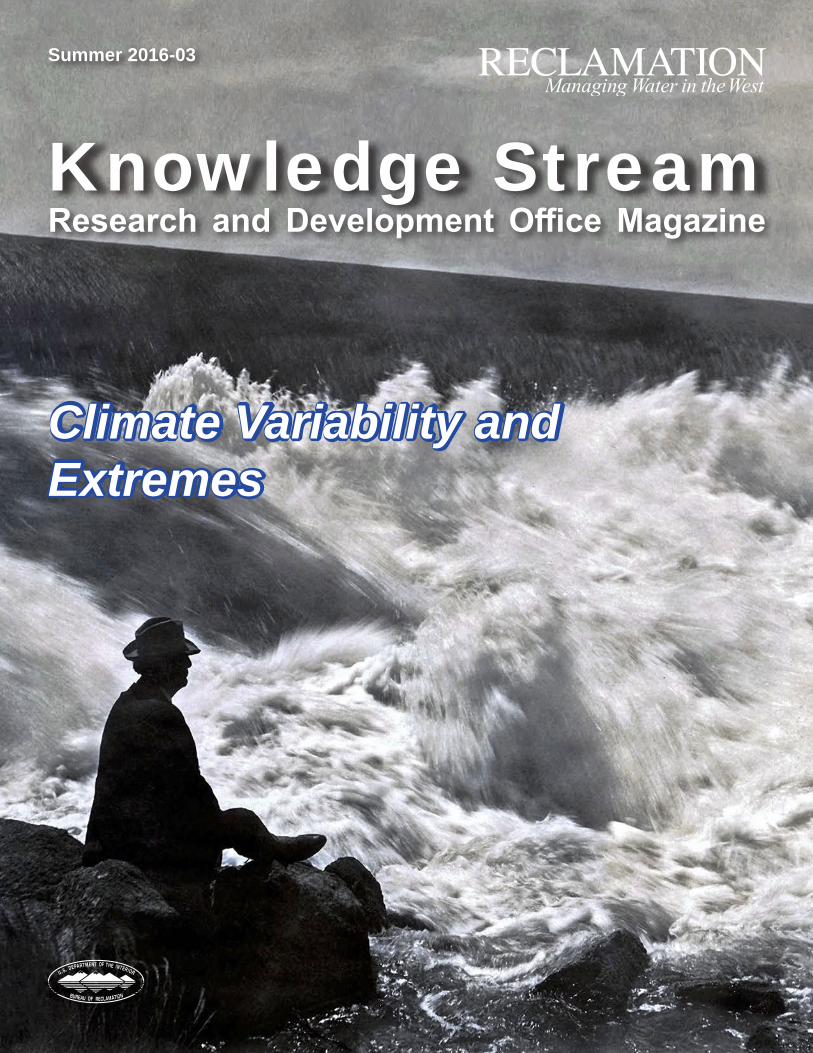
Front Cover: Floodwaters on the Snake River overtop Minidoka Dam. Minidoka Project, Idaho, January 1947.
Back Cover: Dropped water level in the Little Wood River Reservoir due to drought. Little Wood River Project, Idaho, August 1977.
U.S. Department of the Interior Bureau of Reclamation
27
