keynote - settlement hierarchy ·...
TRANSCRIPT
Forest of Dean District Council: July 2011 (Core Document 15)
Keynote - Settlement Hierarchy
1 Introduction 3
2 Regional Context 4
3 Local Context 5
4 Why is a Settlement Hierarchy needed? 74.1 The purpose of a Settlement Hierarchy 74.2 What are Settlements? 74.3 The role of the planning system 74.4 The Current Situation 8
5 National Policy 9
6 Methodology 106.1 Baseline 106.2 Settlement Services Table 11
7 Results 147.1 Settlement Hierarchy Map 147.2 Market Towns 167.2.1 Lydney 187.2.2 Cinderford 197.2.3 Coleford 207.2.4 Newent 227.3 Other Settlements 23
8 Conclusion 27
9 Appendix A: Policy Background 28
10 Appendix B: Comparative Matrix of Services & Facilities in the Forest of DeanSettlements 30
Forest of Dean District Council: July 2011 (Core Document 15) Keynote - SettlementHierarchy
Contents
1 Introduction1.1 The Local Development Framework (LDF) must carefully consider the way in whichthe settlements in the District relate one to another. The policies in the Core Strategy usethese relationships and the general hierarchy of settlements.
1.2 The role of this paper is therefore to;
Explain the role of national policy in the hierarchyProvide background evidence for a settlement hierarchy as used in the LDF
1.3 An understanding of the settlement hierarchy is important as the Local DevelopmentFramework (LDF) must set out a clear order of preference for the location of development.This needs to be robust, not just for the short term in the context of limited or no housingsupply, but in the longer term when development requirements change.
1.4 Whilst the hierarchy will indicate the most sustainable locations for development, itdoes not follow that levels of development will be equal amongst settlements at each levelwithin the hierarchy. Levels of development will be dependant on strategic policy direction,suitable sites being available and other development constraints such as flooding. Since thehierarchy takes into account the presence of services as well as size, it does not follow thatthe largest settlements necessarily have the largest allocations, although there is a strongrelationship between size and the scale of change envisaged.
3Keynote - Settlement Hierarchy Forest of Dean District Council: July 2011 (CoreDocument 15)
1Introduction
2 Regional Context2.1 The Forest of Dean lies in the northern most part of southwest England, being separatedfrom the southwest penisula by the River Severn. Much of the District looks to Gloucesterand to a lesser extent Cheltenham for main services, but the influence of other centres suchas Bristol, Newport and Hereford is also clear.
2.2 Throughout the wider area there are a range of settlements that exist in a loosehierarchy. Those which affect the Forest of Dean begin with centres such as Bristol,Gloucester/Cheltenham and continue through other larger towns and market towns. Theseinclude a number of towns such as Hereford, Ledbury, Ross on Wye, Monmouth, Chepstow,Newport and Cardiff. The smaller of these (eg Chepstow, Ross and Monmouth) are notsignificantly larger than the towns within the Forest of Dean but have more developed centres.
2.3 The key linkages by road are the M50, A40, A48, A4136, A4151, A466, with with theGloucester to Cardiff passing through the south of the District, having a station at Lydney.
Forest of Dean District Council: July 2011 (Core Document 15) Keynote - SettlementHierarchy4
Regional Context2

3 Local Context3.1 The Forest of Dean District, between the River Severn and the River Wye is largelyrural in character. The District has four towns: Cinderford, Coleford, Lydney and Newent.
3.2 Cinderford is located in the heart of the Forest of Dean and is closely related to thesettlement of Ruspidge, with a combined population of around 10,000. Heavy industry hashad a significant influence on the development of the area and this legacy is particularlystrong in Cinderford and Ruspidge. Most of the existing town dates back to the late eighteenth,nineteenth and twentieth centuries, and the town still has a strong manufacturing base. Thearea has a number of problems to solve but equally has opportunities to exploit and the townand surrounding area is at an important stage in its development.
3.3 Lydney is the most southerly of the four Forest of Dean towns. It is accessible by train,situated on the route between South Wales and the Midlands, and the A48 connects thetown to Chepstow and Gloucester. The town has an attractive settling between the Forestand the Severn Valley. Historically, the town was a port for the Forest of Dean area, especiallyfor exporting raw materials such as stone, coal, and iron and timber until the demise of thoseindustries. It also acted as an agricultural market town including a river-based economy anddeveloped manufacturing skills to serve the surrounding countryside. The manufacturingtradition was stimulated by the mining and port industries and the railway led to themanufacturing base broadening further. However, Lydney has followed the national trendof the decline in the mining andmanufacturing sectors, and in structural changes to agricultureand retail. The town currently has a population of around 9,000.
3.4 Coleford is an attractive historic market town at the western edge of the Forest of Dean,approximately 16km north of Chepstow. Whilst the town itself is relatively small (having apopulation of approximately 6,000), it is closely related to a group of settlements, includingMilkwall, Mile End and Coalway, which though separate are mainly in the same parish andeffectively double the population. The town is large enough to support a wide range ofservices and shopping facilities. Heavy industry has had a significant influence on thedevelopment of the area and the area has been generally fortunate to escape the legacy ofdereliction, which affects many other post-industrial locations. Coleford has an attractiveand historic centre and lies in a bowl surrounded by open countryside, which has meant thatthere have been few opportunities for expansion without losing this valuable setting. Colefordlies close to the Wye Valley Area of Outstanding Natural Beauty and the town benefits fromvisiting tourist activity. Industrial activity has generally declined leaving Coleford and itssurrounding area to develop, expand and adapt its role as a market town providing shoppingand other services to its hinterland.
3.5 Newent is a small traditional market town in the north of the Forest of Dean Districtand is located approximately 15km from Gloucester. Newent is smaller than the other threeForest towns with a population of around 4,500. Newent has an ancient history and is thoughtto have Roman origins. The medieval street pattern and the central market place are two ofthe town’s most attractive features. The countryside surrounding the town provides highquality agricultural land with medium-sized farms specialising in dairying, fruit growing, and
5Keynote - Settlement Hierarchy Forest of Dean District Council: July 2011 (CoreDocument 15)
3Local Context

horticulture, together with forestry. The landscape is characterised by gently rolling land withsmall villages and scattered settlements within it. Newent has a high quality built environment,which was designated as a conservation area in 1979. Today, the town remains an importantservice centre for the surrounding settlements providing a wide range of leisure, entertainment,welfare, education and retail facilities, as well as acting as a focus for tourism within thenorthern part of the Forest of Dean.
3.6 Outside of the four main towns, individual settlements vary considerably from one partof the District to another. Most of the smaller settlements have strong interconnections withother small settlements, with one of the four main towns and/or one of the larger settlementsoutside of the District (e.g. Gloucester or Chepstow).
3.7 The individual settlements display their own development layout characteristics andform. Generally in the north they are compact and have clear physical boundaries with areasof ribbon development adjoining some. In the south many of the villages away from thestatutory Forest have developed from small hamlets and are relatively concentrated built upareas within agricultural landscapes. Around the Forest itself is an almost continuous formof built development encircling the core woodland and the minerals outcrop (coal, iron ore)that approximately coincides with the perimeter of the Statutory Forest. This so called "forestring" contains a large number of villages which are dominated by a distinctive settlementpattern that displays a loosely aggregated built form punctuated by open areas in the formof forest waste and paddocks. This pattern is very different from the more traditional formsof villages found in other parts of the District, and the country as a whole.
Forest of Dean District Council: July 2011 (Core Document 15) Keynote - SettlementHierarchy6
Local Context3

4 Why is a Settlement Hierarchy needed?
4.1 The purpose of a Settlement Hierarchy
4.1 Settlements work by providing services for a wider area. The bigger the settlement themore services it tends to have. Over time a settlement hierarchy has been established in theDistrict with the market towns providing most of the services. The smaller settlements havebeen limited to providing local services. As car ownership has increased these local villageservices have tended to decline.
4.2 What are Settlements?
4.2 Settlements are not just a collection of dwellings. They provide services, facilities andinfrastructure for their inhabitants and the wider area. The bigger the settlement the moreservices it tends to have, although this is not always the case. Over time a settlementhierarchy has been established in the District with the towns providing many of the servicesand facilities for the whole District. As car ownership has increased, local village serviceshave tended to decline, and even some of the largest villages in the District in terms ofpopulation lack many basic facilities like a post office or general store. One further influenceis the economy, the cycles of which have an impact on service provision and on the healthand nature of businesses. This impact is clearly apparent in many areas including the Forestof Dean which is and will continue to be vulnerable to reductions in private investment andpublic expenditure.
4.3 The role of the planning system
4.3 One of the key aims of the planning system is to create sustainable communities bybringing housing, jobs and services closer together in an attempt to reduce the need fortravel. This is an important ambition of the LDF for the Forest of Dean and the establishmentof a settlement hierarchy is a key starting point for much of this. The settlement hierarchyhelps by giving a basic understanding of the way in which the settlements interrelate andenables growth to be planned in those settlements that have a range of services andemployment opportunities, while those that do not can be restricted.
4.4 Whilst to an extent assumptions about settlement hierarchy have been incorporatedin the existing policy framework, there have been a number of changes in national policy thatmust be taken into account when considering a settlement hierarchy. It is therefore importantthat it is reviewed and updated so that it is fit for purpose and based on sound and up to dateevidence.
4.5 The LDF considers options for change in the future and the establishment of a settlementhierarchy will help inform choices of where new development should be focused in order tosupport the objective to create sustainable communities.
7Keynote - Settlement Hierarchy Forest of Dean District Council: July 2011 (CoreDocument 15)
4Why is a Settlement Hierarchy needed?

4.4 The Current Situation
4.6 The current settlement hierarchy is established through various tiers of policy documentscomprising the following:
Regional Planning Guidance for the South West – RPG10 (September 2001),The Gloucestershire Structure Plan Second Review (1999) andThe Forest of Dean Local Plan (November 2008) - Saved Policies 2008
4.7 The Forest of Dean Local Plan is the most detailed of these documents, setting thecurrent settlement hierarchy (see Appendix A) and builds upon the more strategic approachin the Structure Plan and Regional Planning Guidance. Although these documents will beredundant or may be superceded, the basic principles of hierarchy (derived from evidence)will endure.
4.8 The outgoing Local Plan contains a broadly hierarchical set of policies for settlements.The emphasis then was to concentrate development in the four main towns of the District –Lydney, Cinderford, Coleford, and Newent – and to develop their role and function asaccessible employment, service and transport centres serving the surrounding rural hinterland.This reflected the requirement of national and regional policy to concentrate development incertain locations. Below the towns the local plan made a number of allocations and providedfor a certain scale of development in some villages. These, generally larger villages wereappropriate for a degree of change which could include allocations for further change andnew housing where not allocated in the form of small groups of dwellings. A further tier belowthese villages still have defined settlement boundaries but are considered appropriate onlyfor a smaller scale of development (eg single or pairs of dwellings). The district containsmany very small rural settlements that in the outgoing Local Plan did not qualify for settlementboundaries and are therefore treated as part of the open countryside.
4.9 The broad hierarchy which is reflected in the Local Plan is still present. It has beenfurther explored by examining the services and facilities that are present in the settlements.
4.10 Despite some housing growth in villages across the District, many settlements havegenerally continued to lose their services, especially shops. This follows a general trend ofincreased competition from large supermarkets resulting from increased mobility of thepopulation. However, for those without a car there is more reliance on bus services foreconomic and social links. The larger and more accessible towns have retained their servicesbetter and act as hubs for the smaller, more isolated settlements.
Forest of Dean District Council: July 2011 (Core Document 15) Keynote - SettlementHierarchy8
Why is a Settlement Hierarchy needed?4

5 National Policy5.1 National Planning Policy mainly in the form of Planning Policy Statements (PPS) setsout some of the ground rules for settlement strategies. They are based on principles suchas reducing the need to travel and providing concentrations of services where they can bebest accessed.
PPS1 (Delivering Sustainable Development) and its supplement, PPS3 (Housing),PPS4 (Planning for Sustainable Economic Growth), PPS6 (Planning for Town Centres),PPS7 (Sustainable Development in Rural Areas) and PPG13 (Transport).
5.2 The key principles and elements of these documents are as follows:
Most new development should be directed to existing towns and cities, to help maximiseaccessibility to employment and services by walking, cycling and public transport.In rural areas local service centres should be identified (which might be a country town,a single large village or a group of villages).Most new development should be in or on the edge of existing settlements whereemployment, housing , services and other facilities can be provided close together. Inopen countryside small groups or ribbons of housing development with no services arenot usually appropriate for further housing.With regard to housing, the focus for significant growth should be market towns or localservice centres, well served by public transport and other facilities, with development invillages and other small rural communities only where needed to contribute to theirsustainability. Therefore only limited growth should be expected though the expansionof villages.
5.3 In addition to guidance within the National Planning Policy Statements, the TaylorReview of Rural Economy and Affordable Housing (2008) has aided in informing andinfluencing the development of this background paper.
9Keynote - Settlement Hierarchy Forest of Dean District Council: July 2011 (CoreDocument 15)
5National Policy

6 Methodology
6.1 Baseline
6.1 This paper provides the evidence and justification for the settlement hierarchy policyin the Core Strategy. The Council has assessed the settlement hierarchy through the useof National Strategic Guidance, historic policy, data collected for the GVA Grimley Forest ofDean District Retail Study (prepared in 2008 updated 2011), and a local facilities survey invillages undertaken by Forest of Dean District Council. Other local knowledge has also beenemployed.
6.2 The paper has been prepared in accordance with the existing policy framework, andbuilds upon the existing Local Plan and the research that was undertaken in the preparationof the RSS.
6.3 The facilities survey was originally undertaken in July and August 2007 by the Council,although it has been partially updated since, most recently in May 2011. Officers visitedeach settlement to record facilities. Other sources of data used to compile the lists includedbus timetables, material from the West Gloucestershire Primary Care Trust, the Post Officewebsite, and internet business directories.
6.4 A separate summary of the facilities survey is available which shows the level ofshopping, service, social, cultural, community, and health facilities in each settlement in theDistrict with a defined settlement boundary. The information also recorded identifies whetherthe settlement is accessible and served by public transport, and whether there are significantemployment opportunities available. A single chart summarising this data is reproducedbelow.
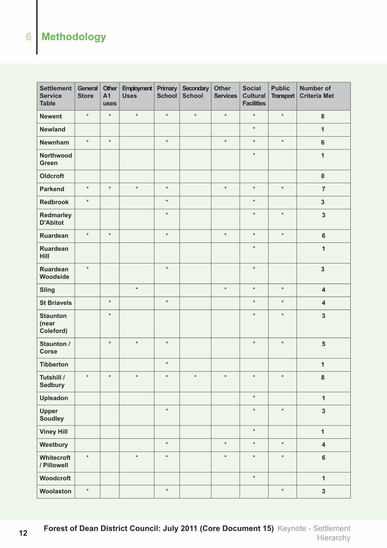
6.5 All locations with a defined settlement boundary have been assessed using the selectioncriteria mentioned above. Services and facilities located within, or adjacent to, or in somecases near to the defined settlement boundary have been recorded. Settlements have thenbeen ranked according to the following requirements which reflect the emphasis on providinga basic level of service for the local rural community and reducing the need to travel, especiallyby private car:
1. At least one general store;2. At least one shop (other than general store) or other A1 use;3. Access to employment opportunities;4. A primary school;5. A secondary school;6. Two or more of the following services: a Post Office, surgery or health centre, bank, A5
food and drink use (e.g. take-away), café / restaurant;7. Two or more of the following types of social facilities: public house(s), community centre
or hall, church, library; and,8. Reasonably accessible by public transport.
Forest of Dean District Council: July 2011 (Core Document 15) Keynote - SettlementHierarchy10
Methodology6

6.2 Settlement Services Table
6.6 The following table indicates the various services available to each settlement withinthe District. A breakdown of settlement classifications can be found in Appendix 3. Theservices recorded are within, or adjacent to, the present defined settlement boundaries.
Number ofCriteria Met
PublicTransport
SocialCulturalFacilities
OtherServices
SecondarySchool
PrimarySchool
EmploymentUses
OtherA1uses
GeneralStore
SettlementServiceTable
3***Alvington
4****Aylburton
3***Beachley
7*******Blakeney
7*******Bream
4****Brierley
1*Brockweir
3***BromsberrowHeath
8********Cinderford
3***Clearwell
8********Coleford
7*******Drybrook /Harrow Hill
4****Dymock
1*Edge End
2**Ellwood
3***EnglishBicknor
5*****Hartpury
6******Huntley
0KempleyGreen
7*******Littledean
6******Longhope
7*******Lydbrook
8********Lydney
8********Mitcheldean
11Keynote - Settlement Hierarchy Forest of Dean District Council: July 2011 (CoreDocument 15)
6Methodology
Number ofCriteria Met
PublicTransport
SocialCulturalFacilities
OtherServices
SecondarySchool
PrimarySchool
EmploymentUses
OtherA1uses
GeneralStore
SettlementServiceTable
8********Newent
1*Newland
6******Newnham
1*NorthwoodGreen
0Oldcroft
7*******Parkend
3***Redbrook
3***RedmarleyD'Abitot
6******Ruardean
1*RuardeanHill
3***RuardeanWoodside
4****Sling
4****St Briavels
3***Staunton(nearColeford)
5*****Staunton /Corse
1*Tibberton
8********Tutshill /Sedbury
1*Upleadon
3***UpperSoudley
1*Viney Hill
4****Westbury
6******Whitecroft/ Pillowell
1*Woodcroft
3***Woolaston
Forest of Dean District Council: July 2011 (Core Document 15) Keynote - SettlementHierarchy12
Methodology6

Number ofCriteria Met
PublicTransport
SocialCulturalFacilities
OtherServices
SecondarySchool
PrimarySchool
EmploymentUses
OtherA1uses
GeneralStore
SettlementServiceTable
1*Worrall Hill
5*****Yorkley /YorkleySlade
13Keynote - Settlement Hierarchy Forest of Dean District Council: July 2011 (CoreDocument 15)
6Methodology

7 Results
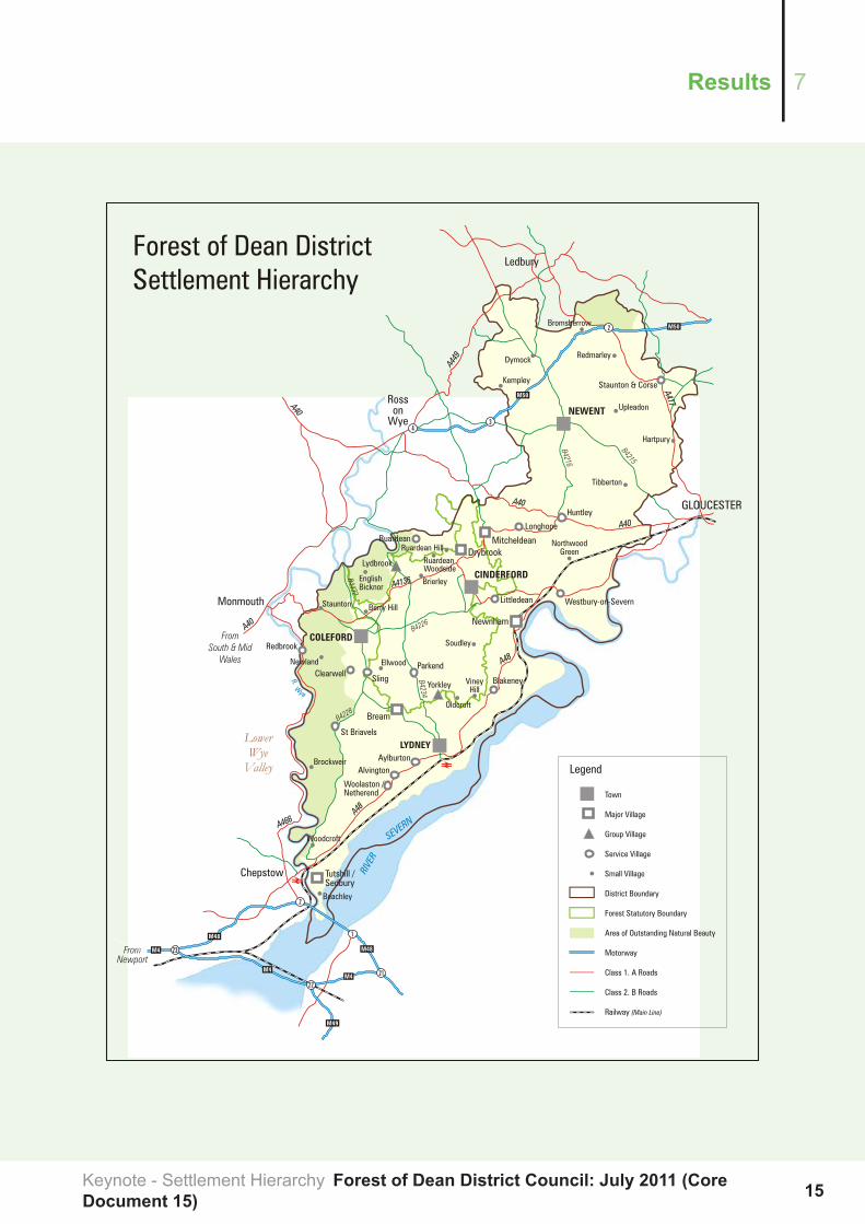
7.1 Settlement Hierarchy Map
7.1 The following map indicates the classification of settlements within the District.
Forest of Dean District Council: July 2011 (Core Document 15) Keynote - SettlementHierarchy14
Results7
15Keynote - Settlement Hierarchy Forest of Dean District Council: July 2011 (CoreDocument 15)
7Results
7.2 Market Towns
7.2 Clearly the four main towns of Lydney, Coleford, Cinderford, Newent meet all the criteriarelating to services and facilities. Going beyond that, the level of service provision does varybetween the towns though the three southern towns have quite similar numbers of shopunits. One, Lydney has a railway station, while all share services. All have secondaryschools, two (Lydney and Cinderford) have small hospitals. The future development of thetowns is governed by their facilities by their potential to accommodate change and byrequirement to develop the area in the most sustainable manner, encouraging greater "selfcontainment".
7.3 All of the settlements surveyed are subject to constant change as the economics ofservice provision also change. These affect both services provided by government (egschools) and those privately funded (shops, pubs etc). As a consequence changes in theinformation set out in the above table will be frequent. The overall hierarchy will change lessand the distinction between large and small will remain, though it is at the present likely tobe against a diminishing range of provision.
7.4 Like other services the level of bus provision is under review because of the need toreconsider the degree to which they can be subsidised. A general reduction in the level ofbus services in the district is likely at least during the early part of the period of the CoreStrategy
7.5 The next largest settlement after the four towns is Tutshill and Sedbury which togetherhave a population of 4500. They meet the eight criteria, as would be expected but in a verydifferent way to the towns. Possibly because of their close relationship with Chepstow,services in Tutshill and Sedbury are dispersed more in the manner that would be expectedin part of a larger town and the settlements do not have a particular location which acts asa focus and which could reasonably constitute a ‘town centre’. Their proximity to Chepstowmeans that most of the services that they require are found there and are in easy reach. Forthe purposes of the Core Strategy however, they are regarded as the largest of five "majorvillages" and are treated accordingly. Because their population is over 3000, the affordablehousing thresholds applicable to larger settlements apply.
7.6 Mitcheldean too meets all 8 criteria, and it also has a very large quantity and range ofemployment. Its population is just under 2500. As far as the settlement hierarchy is concernedit has good access to services and some capacity for further change. Its centre lies just offone of the main routes through the district (A4136).
7.7 The other three of the largest settlements (Bream, Drybrook and Newnham) also havea good range of services and facilities. Bream is the largest (population approximately 2600)and has the greatest range of services. It is situated on a secondary road and is reasonablyaccessible. Historically, Newnhamwasmore important than the forest towns but now functionsas a large village with some services and transport connections. Its population is less thanthe other major villages but its function and services present put it above others in thehierarchy. An example of this comparison would be with the village of Ruardean which has
Forest of Dean District Council: July 2011 (Core Document 15) Keynote - SettlementHierarchy16
Results7

a similar population but fewer services and facilities. The explanation for this is partly historicand partly the better access along the A48 enjoyed by Newnham. Drybrook and its closeneighbour Harrow Hill is the fifth of the largest villages, having a population of over 2000 andthe last of those defined as major villages.
7.8 Below the towns and the five largest villages, the hierarchy becomes less distinct.There are some villages that are relatively small that have a reasonable range of servicesand there are others of a similar size which do not. Especially in the forest ring the natureof the villages means that one merges with another and the services in one may serve severalwithin easy distance (for example Whitecroft and Pillowell). Other influences are alsorevealed. Settlements on a major road will inevitably have better services and often are onpublic transport routes (for example Blakeney, Parkend). Accessibility therefore plays animportant part in selecting settlements for a particular role. Those that are on a main roadand have a petrol station often also have a store (Huntley, Brierley and Alvington for example).
7.9 Two groups of settlements have been identified and are treated as groups rather thanas separate villages. The first of these forms a major part of the so called forest ring. Thisis Whitecroft, Pillowell and Yorkley, which are a group with a population of about 2300. Theycontain two schools, several shops and some employment together with a number of halls,churches and public houses. Because of their close proximity and complementary nature,they are treated together in the Core Strategy. The other example is Joys Green, Lydbrookand Worrall Hill which are closely associated though this association is affected by steepterrain. Together they have a population of over 1200, and a range of services, albeit almostall in Lydbrook.
7.10 Below the grouped villages in the hierarchy there are three main categories that areused in the Core Strategy. These are divide by size and by the presence of services. Thefirst of these are the so called service villages that possess a number of basic services andare larger than the "small" villages, which still may have some local service role but generallynot a range of facilities. The second category is those small villages and the third is thegenerally much smaller settlements which because of their size or other characteristics (suchas a dispersed nature) do not have a defined boundary in the 2005 Local Plan. The threecategories all contain settlements with distinctive characteristics, largely defined by theirlocation. There are some which are part of the Forest fringe, some nucleated settlementsin agricultural land, and some which show particular historic origins (eg Staunton and Corse).
7.11 Turning back to the main towns of Lydney, Coleford, Cinderford and Newent, theGVA Grimley Forest of Dean District Retail Study 2008, ()undertook an assessment of themain facilities within each town centre and a summary of the results is set out below:
http://www.fdean.gov.uk/nqcontent.cfm?a_id=6486&tt=graphic
17Keynote - Settlement Hierarchy Forest of Dean District Council: July 2011 (CoreDocument 15)
7Results

7.2.1 Lydney
7.12 Lydney is the main town serving the southern part of the south Forest with a widecatchment area including several large settlements, such as Bream. The composition of thecentre is as follows in Table 2:
7.13 Table 2: Lydney Town Centre – Retail and Land Use Composition
No of UnitsSector
8A1 Convenience
49A1 Comparison
42Service
5Vacant
2Miscellaneous
106Total
Source: Forest of Dean Council Survey 2007
7.14 Lydney has a large Tesco store on the southern edge of the town centre and a Co-opstore on Newerne Street. There is also a Tuffins store in the town centre accessed fromHams Road, adjacent to the bus station. In addition to these three national operators, thereare also a number of independent convenience retailers in the town including a baker andnewsagents.
7.15 In the comparison goods sector, the only national major retailers were LloydsPharmacy, Oxfam Charity Shop (since closed) and Travis Perkins. A Greggs bakery hassince opened. The remainder of comparison retailers consist of independent retail units,including a range of clothing, electrical, personal goods and books/arts/crafts shops. In theservice sector, there were a number of high street banks, building societies and estate agents,plus hair salons and a selection of food and drink establishments.
7.16 Outside the town centre, there are limited further retail facilities in Lydney. The mainfacility is at Taurus Crafts which is located to the south west of the town and includes craft,art, food and gardening supplies. There is also a DIY, gardening and electrical store onForest Road just outside the town centre. Some units within the industrial estates offervarious specialist goods for retail.
7.17 Bus services visiting Lydney link the town to Chepstow and Gloucester with an hourlyservice running Monday to Saturday and a more limited service on Sundays. The bus stationis located at the eastern end of the town centre on Hams Road and provides an accessiblelocation for town centre visitors.
Forest of Dean District Council: July 2011 (Core Document 15) Keynote - SettlementHierarchy18
Results7
7.18 Overall Lydney was and still is assessed to be a reasonably healthy centre with areasonably good range of shops and services, albeit limited to largely local independentbusinesses in the comparison sector. It has, by a small margin, the highest number of retailand service units in any of the four main Forest centres.
7.2.2 Cinderford
7.19 The retail composition of Cinderford town centre is shown in Table 3 below:
7.20 Table 3: Cinderford Town Centre – Retail and Land Use Composition
No of UnitsSector
11A1 Convenience
32A1 Comparison
35Service
15Vacant
4Miscellaneous
97Total
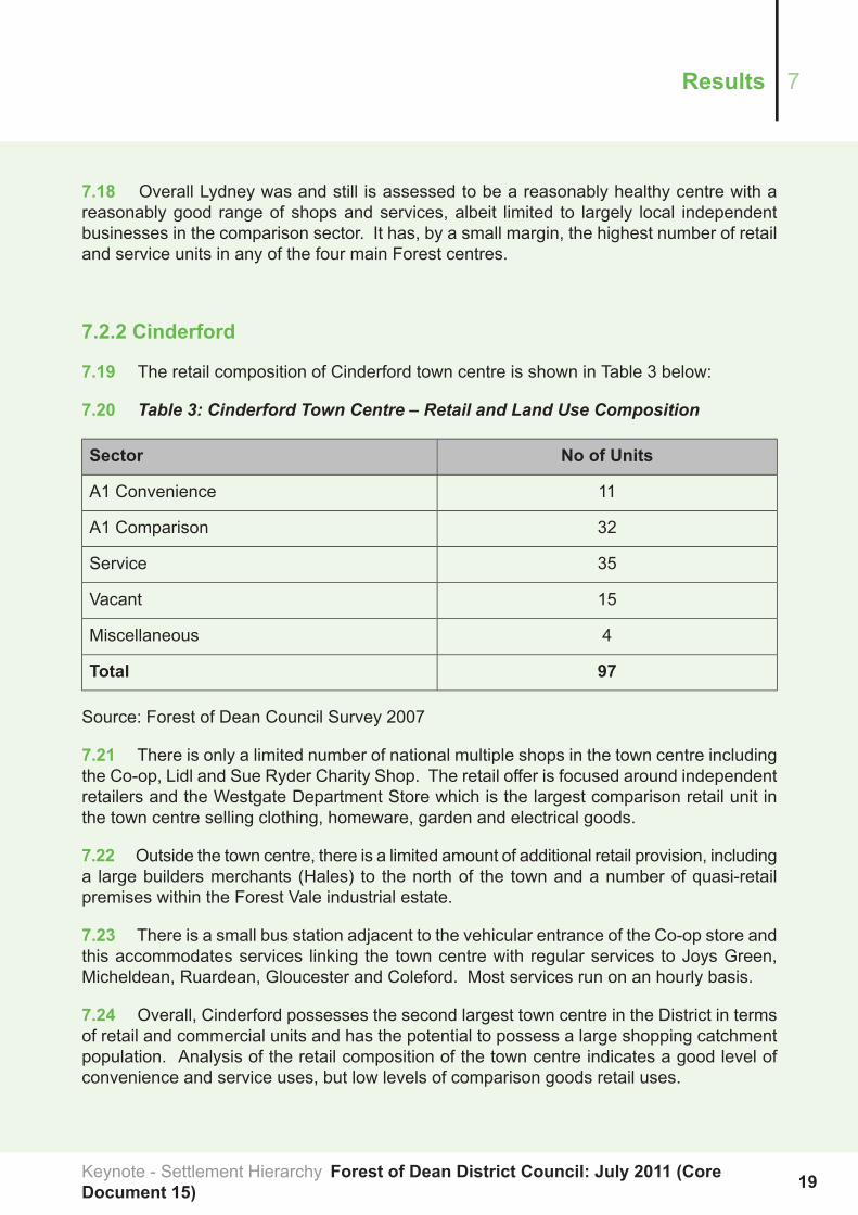
Source: Forest of Dean Council Survey 2007
7.21 There is only a limited number of national multiple shops in the town centre includingthe Co-op, Lidl and Sue Ryder Charity Shop. The retail offer is focused around independentretailers and the Westgate Department Store which is the largest comparison retail unit inthe town centre selling clothing, homeware, garden and electrical goods.
7.22 Outside the town centre, there is a limited amount of additional retail provision, includinga large builders merchants (Hales) to the north of the town and a number of quasi-retailpremises within the Forest Vale industrial estate.
7.23 There is a small bus station adjacent to the vehicular entrance of the Co-op store andthis accommodates services linking the town centre with regular services to Joys Green,Micheldean, Ruardean, Gloucester and Coleford. Most services run on an hourly basis.
7.24 Overall, Cinderford possesses the second largest town centre in the District in termsof retail and commercial units and has the potential to possess a large shopping catchmentpopulation. Analysis of the retail composition of the town centre indicates a good level ofconvenience and service uses, but low levels of comparison goods retail uses.
19Keynote - Settlement Hierarchy Forest of Dean District Council: July 2011 (CoreDocument 15)
7Results
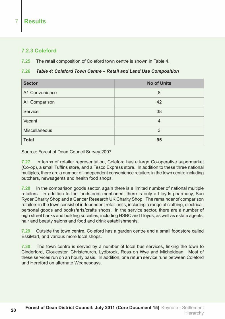
7.2.3 Coleford
7.25 The retail composition of Coleford town centre is shown in Table 4.
7.26 Table 4: Coleford Town Centre – Retail and Land Use Composition
No of UnitsSector
8A1 Convenience
42A1 Comparison
38Service
4Vacant
3Miscellaneous
95Total
Source: Forest of Dean Council Survey 2007
7.27 In terms of retailer representation, Coleford has a large Co-operative supermarket(Co-op), a small Tuffins store, and a Tesco Express store. In addition to these three nationalmultiples, there are a number of independent convenience retailers in the town centre includingbutchers, newsagents and health food shops.
7.28 In the comparison goods sector, again there is a limited number of national multipleretailers. In addition to the foodstores mentioned, there is only a Lloyds pharmacy, SueRyder Charity Shop and a Cancer Research UKCharity Shop. The remainder of comparisonretailers in the town consist of independent retail units, including a range of clothing, electrical,personal goods and books/arts/crafts shops. In the service sector, there are a number ofhigh street banks and building societies, including HSBC and Lloyds, as well as estate agents,hair and beauty salons and food and drink establishments.
7.29 Outside the town centre, Coleford has a garden centre and a small foodstore calledEskiMart, and various more local shops.
7.30 The town centre is served by a number of local bus services, linking the town toCinderford, Gloucester, Christchurch, Lydbrook, Ross on Wye and Micheldean. Most ofthese services run on an hourly basis. In addition, one return service runs between Colefordand Hereford on alternate Wednesdays.
Forest of Dean District Council: July 2011 (Core Document 15) Keynote - SettlementHierarchy20
Results7
7.31 Overall, Coleford is considered to be a healthy centre, which caters well for localresidents. Household telephone surveys indicate high levels of expenditure leakage fromthe town, which suggests that the centre is not particularly attractive to local residents for awide range of shopping, although the comparison goods retention rate is comparative toother Forest towns.
21Keynote - Settlement Hierarchy Forest of Dean District Council: July 2011 (CoreDocument 15)
7Results

7.2.4 Newent
7.32 The retail composition of Newent town centre is shown in Table 5.
7.33 Table 5: Newent Town Centre – Retail and Land Use Composition
No of UnitsSector
10A1 Convenience
23A1 Comparison
31Service
5Vacant
0Miscellaneous
69Total
Source: Forest of Dean Council Survey 2007
7.34 There are fewer units in Newent than the other three centres, and the proportion ofservice units is higher reflecting its role as a rural service centre.
7.35 Newent has Costcutter, Co-operative sumermarket (Co-op) and Budgens foodstores,the latter of which is the largest of the three. In addition, there are a number of independentconvenience retailers including confectioners, newsagents, butchers, delicatessen,healthfoods, greengrocers and a small general stores. Overall, for a town of its size, therange of convenience stores is considered to be good.
7.36 In the comparison goods sector, there were no national multiple retailers but a numberof independent specialist and niche retailers. The centre had three banks including Barclaysand Lloyds.
7.37 Outside of the town, there are a couple of garden centres to the north of the mainurban area.
7.38 The town is visited by bus services, including an hourly service to Ross on Wye andHereford. One return service to Gloucester also runs each Tuesday and Friday.
7.39 In summary, Newent is the smallest town centre in the Forest of Dean in terms of thenumber of retail and commercial units available and serves a rural hinterland in the northernpart of the District. General shopping provision is limited but reasonably healthy.
Forest of Dean District Council: July 2011 (Core Document 15) Keynote - SettlementHierarchy22
Results7

7.3 Other Settlements
7.40 In order to enable rural communities to thrive, some development, particularly economicdevelopment may be appropriate in small amounts in villages and small towns. PlanningPolicy Statement 4 (PPS4), indicates that local planning authorities should support economicdevelopment which enhances rural service centres and locate most new development insettlements where employment, housing (including affordable housing), services, and otherfacilities can be provided close together.
7.41 Table 1 below shows that there are several settlements in addition to the markettowns previously mentioned which have a range of facilities, services, and employmentopportunities. The following settlements meet a least 4 criteria:
Serviced Settlements (excluding the four towns)
BreamBlakeneyAylburton
HartpuryDymockDrybrook / Harrow Hill
LonghopeLittledeanHuntley
Newnham on SevernMitcheldeanLydbrook/Joys Green
SlingRuardeanParkend
Yorkley / YorkleySladeWhitecroft / PillowellTutshill / Sedbury
7.42 The settlements shown in the table above have a broader range of facilities than othersettlements assessed, and therefore are better placed to support a limited amount of additionaldevelopment. However, they have significantly fewer facilities and a much narrower rangeof services than the four main towns. The five largest still stand out and with the exceptionof Newnham (score 6) have a score of 7 or over. When the range rather than just the presenceof services is considered, the differences between the fivemajor settlements and the remainderbecomes more pronounced. Others with a high score include Lydbrook/Joys Green, WorrallHill, Whitecroft/Pillowell and Yorkley/Yorkley Slade. These are the two grouped settlements.Some which are not major villages nor grouped settlements have a relatively high score andtherefore a range of services. These include Blakeney, Littledean, Longhope, Parkend andRuardean. These are all regarded as "service villages" along with smaller generally lesswell provided villages in the list above. Also regarded as service villages are several othervillages which have been added to this category. These are Alvington, Clearwell, Sling, andSt Briavels. All four have a level of services and are readily distinguishable from the nexttier of small settlements. Finally, Staunton and Corse has been added to the "service village"category; this somewhat fragmented and dispersed settlement extends beyond its definedsettlement boundary which has been drawn to protect its dispersed character frominappropriate development. There are several services and facilities outside of the definedboundary but relatively accessible to most of its population.
23Keynote - Settlement Hierarchy Forest of Dean District Council: July 2011 (CoreDocument 15)
7Results

7.43 Below the service villages category, the remaining settlements are generally smallerand have a limited range of services. Included within these are a number that have somefacilities and several that have almost none. Also included is Dymock which is consideredto have more in common with the smaller villages than with those in the category above.
7.44 Although the hierarchy divides the settlements into six categories, in practice thedivisions are blurred. It is however a useful indication of the function of the towns and villagesand the analysis does clearly show a distinct group of major villages and two groups whichare larger and more sustainable locations for modest additional development. Equally thesmaller settlements with few if any service provision can be readily identified. This hierarchyinforms the Core Strategy and will be referred to in the development of other planning policydocuments. It should however be taken only as a general guide and broad illustration of thenature of the settlements that are present in the district.
7.45 In some areas of the Forest of Dean the close proximity of settlements means thatservices and facilities in one may serve a neighbouring settlement and vice versa. Someindividual settlements may not have the size of population to support certain services but theclose proximity of one or two other settlements may make a service viable. Examples of thiscan be found in the ring of settlements around the Statutory Forest, including Ruardean /Ruardean Woodside / Ruardean Hill, Ellwood / Sling, and Yorkley / Pillowell / Whitecroft.
7.46 Notwithstanding the inter-relationships between the above settlements, all of thevillages rely on many of the services and facilities provided in the nearest of the four maintowns in the District, or larger towns and cities outside the District. Residents of thesettlements listed in Table 1 are within the general catchments of the following largersettlements:
Service Catchment Area
SettlementsMain Settlement
Alvington, Aylburton, Blakeney, Bream, Oldcroft,Parkend, Viney Hill, Whitecroft / Pillowell,Woolaston, Yorkley/Yorkley Slade (combinedpopulation 9100 approx)
Lydney town population approx 9000
Clearwell, Edge End, Ellwood, English Bicknor,Lydbrook/Joys Green, Newland, Parkend,Redbrook, St Briavals, Sling, and Staunton(combined population 5300 approx)
Coleford town population 11000approx
Brierley, Drybrook / Harrow Hill, Littledean,Longhope, Lydbrook, Mitcheldean, Newnham,Northwood Green, Ruardean, Ruardean Hill,Ruardean Woodside, Upper Soudley, Westbury,Worrall Hill (combined population 11,900 approx)
Cinderford andRuspidge population10000 approx
Forest of Dean District Council: July 2011 (Core Document 15) Keynote - SettlementHierarchy24
Results7
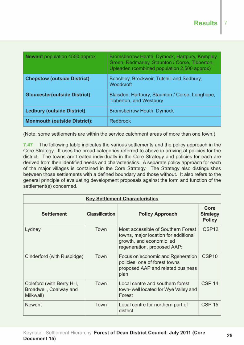
Bromsberrow Heath, Dymock, Hartpury, KempleyGreen, Redmarley, Staunton / Corse, Tibberton,Upleaden (combined population 2,500 approx)
Newent population 4500 approx
Beachley, Brockweir, Tutshill and Sedbury,Woodcroft
Chepstow (outside District):
Blaisdon, Hartpury, Staunton / Corse, Longhope,Tibberton, and Westbury
Gloucester(outside District):
Bromsberrow Heath, DymockLedbury (outside District):
RedbrookMonmouth (outside District):
(Note: some settlements are within the service catchment areas of more than one town.)
7.47 The following table indicates the various settlements and the policy approach in theCore Strategy. It uses the broad categories referred to above in arriving at policies for thedistrict. The towns are treated individually in the Core Strategy and policies for each arederived from their identified needs and characteristics. A separate policy approach for eachof the major villages is contained in the Core Strategy. The Strategy also distinguishesbetween those settlements with a defined boundary and those without. It also refers to thegeneral principle of evaluating development proposals against the form and function of thesettlement(s) concerned.
Key Settlement Characteristics
CoreStrategyPolicy
Policy ApproachClassificationSettlement
CSP12Most accessible of Southern Foresttowns, major location for additional
TownLydney
growth, and economic ledregeneration, proposed AAP:
CSP10Focus on economic and Rgenerationpolicies, one of forest towns
TownCinderford (with Ruspidge)
proposed AAP and related businessplan
CSP 14Local centre and southern foresttown- well located for Wye Valley andForest
TownColeford (with Berry Hill,Broadwell, Coalway andMilkwall)
CSP 15Local centre for northern part ofdistrict
TownNewent
25Keynote - Settlement Hierarchy Forest of Dean District Council: July 2011 (CoreDocument 15)
7Results

Key Settlement Characteristics
CoreStrategyPolicy
Policy ApproachClassificationSettlement
CSP 16Large villages with employmentand/or services important to a wider
Major VillageTutshill and Sedbury,Bream, Drybrook and
area. Some scope for additionaldevelopment
Harrow Hill, Mitcheldean,Newnham,
CSP 16Villages which can be consideredpart of a group with common facilities
Group VillageWhitecroft-Pillowell-Yorkley,Joys
and services in close proximity. MayGreen-Lydbrook-WorrallHill, offer potential for small housing sites
within existing settlement, and foraffordable housing outside
CSP 16Except for possible affordablehousing as an exception, and
ServiceVillage
Alvington, Aylburton,Blakeney, Clearwell,
existing allocations, new housing andHuntley, Littledean,employment opportunities are likelyLonghope, Parkend,to be small in scale (e.g. single plots,Redbrook, Ruardean, Stor pairs, small workshops or changesBriavels, Staunton andof use of existing buildings plus reuse of agricultural buildings)
Corse, Sling, Westbury,Woolaston (Netherend)
CSP 16Some local services/facilities butgenerally very limited opportunity foradditional development. Settlements
Small VillageBeachley, Brierley,Brockweir, BromsberrowHeath, Dymock, Edge
with some services may be suitablefor small affordable housingdevelopments
End, Ellwood, EnglishBicknor, Kempley Green,Hartpury, Newland,NorthwoodGreen, Oldcroft,Redmarley, Ruardean Hill,RuardeanWoodside,Staunton(Coleford), Tibberton,Upleadon, Upper Soudley,Viney Hill, Woodcroft,
CSP 4Will be regarded as part of the opencountryside for most purposes, but
SmallSettlement
Small settlements withoutdefined settlementboundaries may be appropriate locations for
limited affordable housing and ruralemployment as defined in CorePolicies.
Forest of Dean District Council: July 2011 (Core Document 15) Keynote - SettlementHierarchy26
Results7

8 Conclusion8.1 The analysis has enabled the identification of a clear settlement hierarchy within theForest Of Dean District.
8.2 The four main towns of Lydney, Cinderford, Coleford and Newent all have a range offacilities, and meet all the criteria related to shopping, services, social, cultural, communityand health facilities. Consequently, these should be the primary focus for new development.
8.3 Underneath this tier, there are a number of settlements, which have a broader rangeof facilities than the other settlements assessed and, therefore are better placed to supporta limited amount of additional development. However, they have significantly fewer facilitiesand a narrower range of services than the four main towns.
8.4 Below this, many of the smaller settlements lack community facilities, service, publictransport and access to jobs at close hand, and will be generally unsuitable for newdevelopment that is not directly related to their own local needs.
27Keynote - Settlement Hierarchy Forest of Dean District Council: July 2011 (CoreDocument 15)
8Conclusion
9 Appendix A: Policy Background
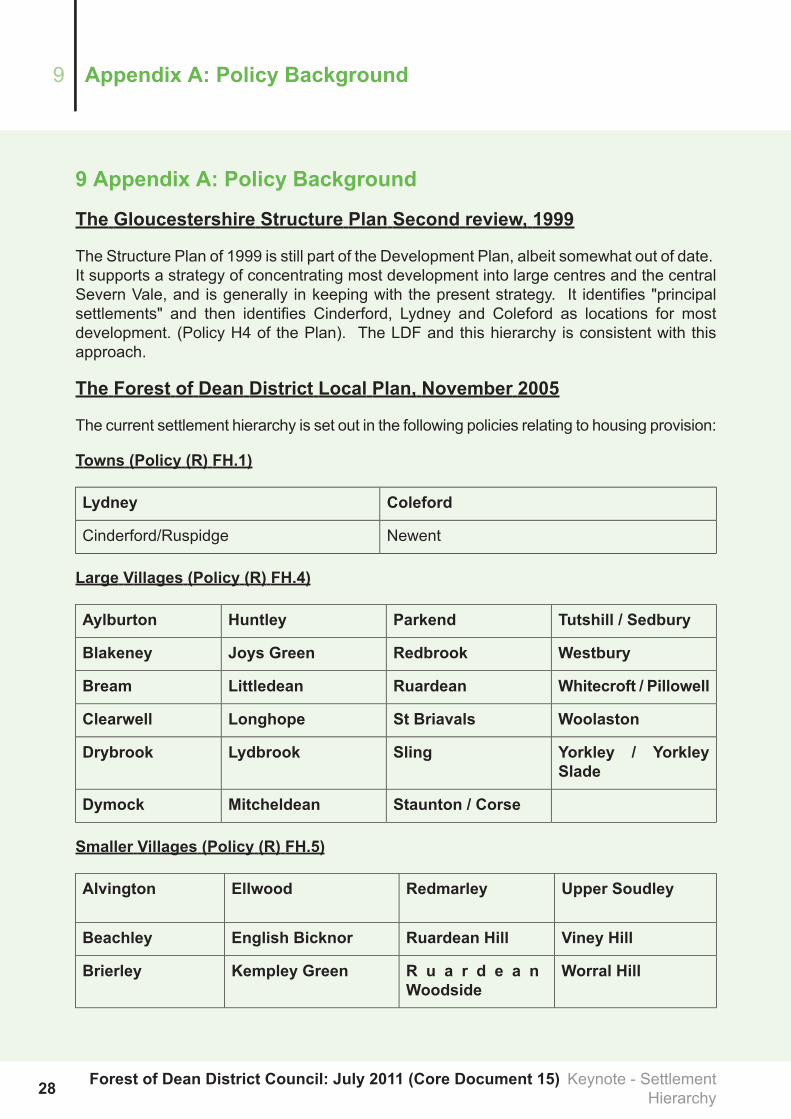
The Gloucestershire Structure Plan Second review, 1999
The Structure Plan of 1999 is still part of the Development Plan, albeit somewhat out of date.It supports a strategy of concentrating most development into large centres and the centralSevern Vale, and is generally in keeping with the present strategy. It identifies "principalsettlements" and then identifies Cinderford, Lydney and Coleford as locations for mostdevelopment. (Policy H4 of the Plan). The LDF and this hierarchy is consistent with thisapproach.
The Forest of Dean District Local Plan, November 2005
The current settlement hierarchy is set out in the following policies relating to housing provision:
Towns (Policy (R) FH.1)
ColefordLydney
NewentCinderford/Ruspidge
Large Villages (Policy (R) FH.4)
Tutshill / SedburyParkendHuntleyAylburton
WestburyRedbrookJoys GreenBlakeney
Whitecroft / PillowellRuardeanLittledeanBream
WoolastonSt BriavalsLonghopeClearwell
Yorkley / YorkleySlade
SlingLydbrookDrybrook
Staunton / CorseMitcheldeanDymock
Smaller Villages (Policy (R) FH.5)
Upper SoudleyRedmarleyEllwoodAlvington
Viney HillRuardean HillEnglish BicknorBeachley
Worral HillR u a r d e a nWoodside
Kempley GreenBrierley
Forest of Dean District Council: July 2011 (Core Document 15) Keynote - SettlementHierarchy28
Appendix A: Policy Background9

Upper SoudleyRedmarleyEllwoodAlvington
WoodcroftStaunton (nrColeford)
NewlandBrockweir
TibbertonNorthwood GreenB r omsb e r r owHeath
UpleadonOldcroftEdge End
29Keynote - Settlement Hierarchy Forest of Dean District Council: July 2011 (CoreDocument 15)
9Appendix A: Policy Background
10App
endixB:C
ompa
rativ
eMatrix
ofSe
rvices
&Fa
cilitiesin
theFo
rest
ofDean
Settlem
ents
Services
andFa
cilitiesin
Forest
ofDeanTowns
andSe
ttlem
ents
Sign
ificant
Employ
men
tMainRoa
dan
dPu
blicTran
sport
(8)
Distanc
eto
Nearest
MainTown
(km)(7)
Second
ary
Scho
olPrim
ary
Scho
ol
Health
Centre/
Doctors
Surgery
Village
/Co
mmun
ityHall
Chu
rch
(6)
Library
Public
Hou
se(5)
Post
Office
A5
Food &
Drin
k
A3
Restaurants
&Café
A2(4)
A1
Services
(3)
A1
Com
paris
on(2)
A1
Convenience
(1)
Approximate
Popu
latio
nTown/S
ettle
men
t
A48
andPublic
Transport
3.6
yes
yes
1388
Alvington
yes
A48
andPublic
Transport
2.3
yes
yes
yes
2429
Aylburton
nearby
Public
Transport
3.4
yes
1241
Beachley
yes
A48
andPublic
Transport
5yes
yes
yes
yes
3yes
12
1791
Blakeney
nearby
B4231
andPublic
Transport
4yes
yes
yes
yes
yes
3yes
12
34
2700
Bream
A4136
andPublic
Transport
3.4
yes
11
179
Brierley
A466
7.5
yes
1106
Brockweir
yes
5.2
yes
yes
1248
BromsberrowHeath
2.7
yes
yes
yes
3yes
1367
Clearwell
nearby
A4136
andPublic
Transport
3.6
yes
yes
yes
yes
2yes
12
23
1800
Drybrook/HarrowHill
B4215
andPublic
Transport
5.4
yes
yes
1yes
1330
Dym
ock
A4136
andPublic
Transport
3yes
157
EdgeEnd
2.8
yes
yes
yes
212
Ellwood
Public
Transport
5yes
yes
yes
207
EnglishBicknor
A417
6.5
yes
yes
1yes
11
1388
Hartpury
A40
andPublic
Transport
6.2
yes
12
900
Huntley
5.6
113
Kem
pley
Green
B4151
andPublic
Transport
1.8
yes
yes
yes
1yes
11
3840
Littledean
yes
A40
andPublic
Transport
5.4
yes
yes
yes
1yes
11
975
Longhope
yes
B4234
andPublic
Transport
5.6
yes
yes
yes
yes
5yes
11
11385
Lydbrook/JoysGreen
yes
A4136
andPublic
Transport
4.4
closeby
yes
yes
yes
yes
3yes
31
14
2413
Mitcheldean
2.6
yes
yes
1142
New
land
A48
andPublic
Transport
4.4
yes
yes
yes
yes
yes
2yes
18
11255
New
nham
-on-Severn
7.1
yes
yes
169
NorthwoodGreen
2.6
123
Oldcroft
yes
B4234
4.8
yes
yes
yes
3yes
11
548
Parkend
A466
3.8
yes
yes
1yes
1398
Redbrook
Limitedbusservices
7yes
yes
yes
Mobile
183
RedmarleyD'Abitot
Public
Transport
5yes
yes
yes
yes
1yes
11
31216
Ruardean
3.6
yes
yes
434
RuardeanHill
4.2
yes
yes
yes
1367
RuardeanWoodside
yes
B4228
andPublic
Transport
2.8
21
898
Sling
B4228
6.4
yes
yes
yes
21
767
StB
riavels
A4136
3.2
yes
yes
11
265
Staunton(nearC
oleford)
yes
A417
7.8
yes
yes
yes
2yes
12
709
Staunton/C
orse
5.4
yes
yes
335
Tibberton
yes
A48
andPublic
Transport
1.5
yes
yes
yes
yes
yes
1yes
21
25
3682
Tutshill/S
edbury
3.2
yes
99Upleadon
Public
Transport
3.5
yes
yes
yes
1355
UpperSoudley
4yes
1128
VineyHill
A48
andPublic
Transport
6yes
yes
yes
yes
1246
Westbury-on-Severn
yes
B4234
3.4
yes
yes
yes
2yes
1900
Whitecroft/Pillow
ell
B4228
2.5
1246
Woodcroft
A48
andPublic
Transport
4.6
yes
yes
11
778
Woolaston
A4136
andPublic
Transport
5376
WorrallHill
3.6
yes
yes
yes
2yes
12
1385
Yorkley/YorkleySlade
Forest of Dean District Council: July 2011 (Core Document 15) Keynote - SettlementHierarchy30
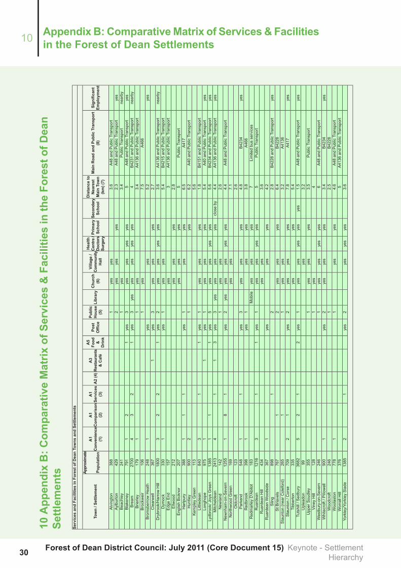
Appendix B: ComparativeMatrix of Services & Facilitiesin the Forest of Dean Settlements10

Services
andFa
cilitiesin
Forest
ofDeanTowns
andSe
ttlem
ents
Sign
ificant
Employ
men
tMainRoa
dan
dPu
blicTran
sport
(8)
Distanc
eto
Nearest
MainTown
(km)(7)
Second
ary
Scho
olPrim
ary
Scho
ol
Health
Centre/
Doctors
Surgery
Village
/Co
mmun
ityHall
Chu
rch
(6)
Library
Public
Hou
se(5)
Post
Office
A5
Food &
Drin
k
A3
Restaurants
&Café
A2(4)
A1
Services
(3)
A1
Com
paris
on(2)
A1
Convenience
(1)
Approximate
Popu
latio
nTown/S
ettle
men
t
Notes:
Thepopulationfigures
have
been
derived
fromhouseholdnumberswithinsettlem
entsbasedon
theArcMap
9_2[GIS
SYSTE
M]and
averagehouseholdsize
inForestofDeanDistrictfromONS,2001Census.
(1)S
upermarkets,butchers,baker,newsagent,offlicence,greengroceretc.(includes
shopswhich
arepartofpetrolstations)
(2)S
hops
selling
durablegoods
(3)H
airdressers,drycleaners,estateagents,etc
(4)B
anks
andfinancialservices
(5)Includessocialclubs
(6)Includeschapels
(7)Lydney,Coleford,Cinderford,orN
ewent(orGloucester,Chepstow,
MonmouthorLedburyinsomeperipheralpartsoftheDistrict)
(8)M
ainRoadiseitherAorBclassifiedroad
/Public
Transportshouldservesettlem
entatleastonce
anhourMon-Fri
31Keynote - Settlement Hierarchy Forest of Dean District Council: July 2011 (CoreDocument 15)
10Appendix B: Comparative Matrix of Services & Facilities in theForest of Dean Settlements