kennecott utah copper corporation managing environmental ... · diving board area tailings 32 ......
TRANSCRIPT
1
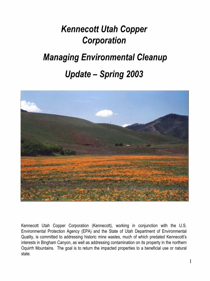
Kennecott Utah Copper Corporation
Managing Environmental Cleanup
Update – Spring 2003
Kennecott Utah Copper Corporation (Kennecott), working in conjunction with the U.S. Environmental Protection Agency (EPA) and the State of Utah Department of Environmental Quality, is committed to addressing historic mine wastes, much of which predated Kennecott’s interests in Bingham Canyon, as well as addressing contamination on its property in the northern Oquirrh Mountains. The goal is to return the impacted properties to a beneficial use or natural state.

2
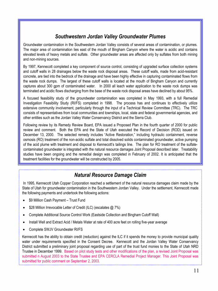
American Avocet at Kennecott’s Inland Sea Shorebird Reserve
3
Table of Contents
KENNECOTT BACKGROUND 4
KUC HISTORICAL TIME LINE 5
GOALS OF KUC ENVIRONMENTAL RESPONSES 6
CHRONOLOGY OF KUC ENVIRONMENTAL 8,9
SOUTH FACILITIES SITES 10HISTORICAL SITES 10SWJV GROUND WATER PLUMES 11NATURAL RESOURCE DAMAGE CLAIM 11BINGHAM CREEK TAILINGS 12SMALL BINGHAM CREEK RESERVOIR 13LARGE BINGHAM CREEK RESERVOIR 13,14EASTSIDE LEACHING AND STORM WATER COLLECTION SYSTEM 15RECLAMATION DEMONSTRATION PROJECT 16SOUTH JORDAN EVAPORATION PONDS 17LARK WASTE ROCK 18LARK TAILINGS (STATE MOTORCYCLE PARK) 19BUTTERFIELD CANYON WASTE ROCK 20HERRIMAN/BUTTERFIELD CANYON SOIL REMOVAL 21
NORTH FACILITIES SITES 22SMELTER FOOTPRINT 23REFINERY FOOTPRINT 24NORTH END GROUND WATER RI/FS 25EP PONDS AT REFINERY 26NORTH END SOILS & WWTP SLUDGE 27ARTHUR STEPBACK REPOSITORY 28SMELTER SLAG LAGOON 29I-80POND 30KESSLER CANYON DRAINAGE 31SMELTER SLAG PILE 32DIVING BOARD AREA TAILINGS 32MAGNA SOILS 32POWER PLANT 32
KENNECOTT ENVIRONMENTAL INITIATIVES 33

4
KENNECOTT BACKGROUND
More than a century of hard-rock mining in Bingham Canyon has made Kennecott’s cleanup task an ongoing process over the last ten years, one that has been built into the company’s mission plan as Kennecott works to meet society’s demand for metals in an environmentally responsible manner.
While results cannot be obtained overnight, there has been steady and significant progress to clean up and reclaim the historic mining wastes and those from Kennecott’s own operations.
Located 28 miles southwest of Salt Lake City, Bingham Canyon’s mining history dates to 1863, when prospectors and miners discovered ore bodies of lead, zinc, silver and gold. Since those days, mining has continued almost non-stop in a variety of fashions in the canyon.
While copper deposits initially were thought to be too marginal to justify mining, engineers Daniel Jackling and RobertGemmell theorized that a large-scale, open-pit copper mine could be profitable. In 1903, Jackling’s Utah Copper Company was formed and a pilot mill built in Bingham Canyon produced a $142,000 profit. In 1906, steam shovels owned by the company made the first cut into what would in the years ahead gain fame as “the richest hole on Earth.”
Leach operations also played a role in the canyon’s mining. Beginning in the 1920s, they were used to pull copper from waste-rock dumps. Kennecott Copper Corporation, which purchased Utah Copper in 1936, built a refinery in 1950 and bought an existing smelter in 1959 to transform the ore body into saleable copper cathodes.
Cleanup operations are not restricted to the canyon, though, as Kennecott works to preserve the environmental integrity of lands impacted by its nearby refining and smelting operations located in the northern Oquirrh Mountains.
While new technologies and more efficient mining methods continue to advance the efficiencies of mining, smelting and refining operations, they don’t negate the need for investments in environmental stewardship. During the 1990s, Kennecott Utah Copper invested $1 billion in the world’s cleanest smelter, one that dramatically reduced both sulfur dioxide and particulate emissions. At the same time, the company spent $500 million to expand and modernize its tailings impoundment and more than $300 million on environmental remediation projects.

5
Timeline of Mining in Bingham Canyon & Smelting & Refining in the Northern Oquirrhs
1863 Initial exploration and mining of mineral resources
1873 Mining boom descends on Bingham Canyon as deposits of lead, silver, zinc and gold are discovered
1906 Large-scale open-pit mining begins in Bingham Canyon
1910s Most mining claims consolidated under Utah Copper Company
1920s Copper artificially leached from waste-rock dumps
1930s The “Hill” becomes the “Pit”
1936 Kennecott Utah Copper purchases Utah Copper Company
1941-45 Mine produces one-third of copper used by Allies during World War II
1950s Refinery constructed and smelter purchased in Northern Oquirrhs;copper production integrated
1960s $100 million modernization of the mine, including a new precipitation plant, new leach system, construction of the Bonneville Crushing and Grinding Plant and the molybdenite processing plant
1970s $300 million investment in smelter with new smelting furnaces and new sulfur dioxide emission control technology
1980s World-wide copper recession leads to a plant shutdown; $625 million plant modernization, including Copperton Concentrator; Kennecottbought by Standard Oil of Ohio, then British Petroleum, and finally Rio Tinto in 1989
1995 $1 billion spent on smelter and refinery modernization, making the new smelter the world’s cleanest as it recovers 99.9 percent of sulfur dioxide emissions
1996 $500 million spent on 3,200-acre tailings impoundment expansion and modernization, including a seismic upgrade
1999 Tailings impoundment upgrade is completed, includes the 3,800-acreInland Sea Shorebird Reserve and Wetland Mitigation Bank near the Great Salt Lake
6
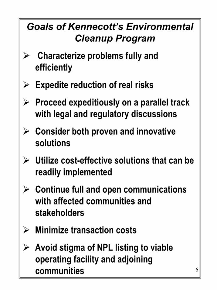
Goals of Kennecott’s Environmental Cleanup Program
Characterize problems fully and efficiently
Expedite reduction of real risks
Proceed expeditiously on a parallel track with legal and regulatory discussions
Consider both proven and innovative solutions
Utilize cost-effective solutions that can be readily implemented
Continue full and open communications with affected communities and stakeholders
Minimize transaction costs
Avoid stigma of NPL listing to viable operating facility and adjoining communities

7
Kennecott Utah Copper Corporation Cleanup ProjectsWhile Kennecott’s predecessors have had a presence in Bingham Canyon since the early 1900s, many of the wastes generated in the area predated Kennecott’s arrival. Still, Kennecott owns most of the property on which the wastes were deposited, and since most of the companies that produced the wastes have long been out of business, Kennecott has agreed to clean up those areas.
Negotiation and cooperation have exemplified the company’s stance towards reclaiming the landscape. These traits rose to the forefront in the 1990s when the EPA proposed to designate some Kennecott properties as Superfund Sites. In 1991, Kennecott officials, concerned that listing of their properties on the National Priorities List (NPL) as Superfund Sites would hamper cleanup efforts both logistically and economically, presented an accelerated cleanup program to EPA officials. Under that plan, Kennecott wanted to move forward with cleanup work as efficiently and effectively as possible, while still meeting cleanup objectives set by the EPA and State of Utah.
Initially, the company’s accelerated program affected twenty “sites” identified by Kennecott, EPA and State of Utah officials. While working on cleanup activities with EPA oversight, Kennecott continued to negotiate the scope of cleanup work with the EPA and State of Utah under an Agreement in Principal reached in 1992. However, an agreement was not reached on a consent decree and on January 17, 1994, the EPA proposed to list the Kennecott South Zone and the Kennecott North Zone on the NPL list. The company, backed with broad-based state and local government and community support, continued to work on its cleanup while negotiations continued with the EPA and State of Utah on a simplified cleanup agreement, one that would accomplish the cleanup to the satisfaction of state and federal officials without the stigma of a Superfund designation.
Such an agreement was reached in September 1995 when the three parties signed a Memorandum of Understanding (MOU) outlining the scope of cleanup work. Under the MOU, Kennecott agreed to complete certain remaining cleanup work, perform specified environmental studies, and complete an ecological risk assessment. In return, EPA officials agreed not to take any final action on the NPL listing and agreed to remove the Kennecott sites from the proposed NPL list when Kennecott completed the work specified under the MOU. The State of Utah, meanwhile, agreed to participate in the review and guidance of the cleanup effort, address permitting as appropriate and avoid duplicative oversight where possible.
Cleanup work, like mining, has been a consistent activity for Kennecott during the last ten years. Through mid-2002, the company has spent more than $340 million to clean up historic mining wastes and install source control measures. This included approximately $20 million to clean up of selenium and other metals in the wetlands near the Great Salt Lake along the I-80 corridor.
The cleanup efforts resulted in approximately 26 million tons (16.25 million cubic yards) of mining wastes being isolated, excavated, relocated, disposed and/or permanently stabilized in place. Approximately 10 million tons (6.25 million cubic yards) of clean materials have been excavated to support the cleanup work. Additionally, more than 3,340 acres of land has been restored, reclaimed or revegetated, including approximately 1,000 acres of new wildlife habitat or open space. Over 120,000 trees, as well as several thousand acres of shrubs, forbs and grasses have been planted.
Approximately 5 million square feet of synthetic liners have been installed on about 100 acres to contain contaminated water and wastes in EPA- and State of Utah-approved repositories, and; more than 60 miles of pipelines (an amount equal to a pipeline running from Park City to Tooele) have been installed to transport contaminated water from the mine area. Over 10 thousand cubic yards (27 thousand tons) of concrete was utilized to create Eastside cutoff walls and reservoir spillways, while more than 580 groundwater monitoring wells have been installed over the South and North Ends of the property.
This work was performed and completed with site-by-site EPA and Utah Department of Environmental Quality (UDEQ) inspection, overview and permitting, as well as with review by other interested parties.

8
CHRONOLOGY OF KUCC ENVIRONMENTAL RESPONSES
1983 KUCC begins five-year Study of Bingham Canyon/Southwestern Jordan Valley groundwater
1986 State of Utah files NRD claim for groundwater contamination in Southwestern Jordan Valley and EPA conducts Preliminary Site Investigations of KUCC facilities
1990 State and EPA sample soils in Bingham Creek KUCC investigates Southwestern Jordan Valley groundwater contamination
1991 KUCC initiates Proactive Cleanup Program, makes NRD settlement offer to State and submits Environmental Action Work Plans EPA/State/KUCC negotiate possible NPL deferral
1992 EPA/State/KUC sign Agreement in Principle on NPLFirst NRD settlement offer rejected by Federal CourtNPL deferral delayed by federal review
1993 Negotiations on NPL Consent Decree fail KUCC sponsors lead-arsenic exposure study for Bingham Creek KUCC completes Large Bingham Reservoir Removal KUCC completes Phase I Bingham Creek Channel (Delta M-8) Removal
1994 EPA proposes KUCC for NPL Negotiations begin again on NPL deferral KUCC completes Butterfield Waste Rock Removal
1995 Kennecott and State of Utah settle Southwest Jordan Valley groundwater NRD EPA/State/KUCC sign MOU on NPL deferral KUCC completes Phase II Bingham Creek Channel Removal
1997 KUCC completes South Jordan Evaporation Ponds RemovalKUCC completes source control measures/installation of Eastside Leach Collection System and Cutoff WallsKUCC drills acid groundwater plume extraction well; initiates pumping
1998 KUCC completes Southwest Jordan Valley groundwater Remedial Investigation and Feasibility Study KUCC completes Ecological Risk Assessment KUCC completes Lark Tailings and Waste Rock RemovalKUCC completes Butterfield Creek Canyon soils / sediments cleanupKUCC completes soils commitment to EPA for Herriman Residential Soils Cleanup
9
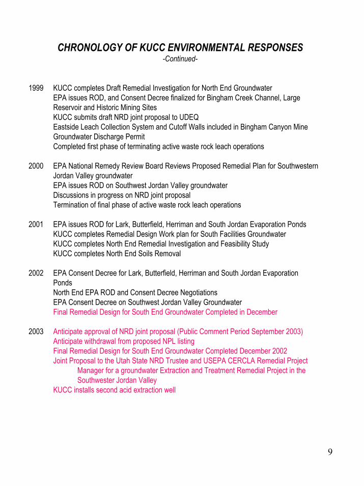
CHRONOLOGY OF KUCC ENVIRONMENTAL RESPONSES-Continued-
1999 KUCC completes Draft Remedial Investigation for North End Groundwater EPA issues ROD, and Consent Decree finalized for Bingham Creek Channel, Large Reservoir and Historic Mining SitesKUCC submits draft NRD joint proposal to UDEQEastside Leach Collection System and Cutoff Walls included in Bingham Canyon Mine Groundwater Discharge PermitCompleted first phase of terminating active waste rock leach operations
2000 EPA National Remedy Review Board Reviews Proposed Remedial Plan for Southwestern Jordan Valley groundwaterEPA issues ROD on Southwest Jordan Valley groundwaterDiscussions in progress on NRD joint proposalTermination of final phase of active waste rock leach operations
2001 EPA issues ROD for Lark, Butterfield, Herriman and South Jordan Evaporation PondsKUCC completes Remedial Design Work plan for South Facilities GroundwaterKUCC completes North End Remedial Investigation and Feasibility StudyKUCC completes North End Soils Removal
2002 EPA Consent Decree for Lark, Butterfield, Herriman and South Jordan EvaporationPondsNorth End EPA ROD and Consent Decree NegotiationsEPA Consent Decree on Southwest Jordan Valley GroundwaterFinal Remedial Design for South End Groundwater Completed in December
2003 Anticipate approval of NRD joint proposal (Public Comment Period September 2003)Anticipate withdrawal from proposed NPL listingFinal Remedial Design for South End Groundwater Completed December 2002Joint Proposal to the Utah State NRD Trustee and USEPA CERCLA Remedial Project
Manager for a groundwater Extraction and Treatment Remedial Project in the Southwester Jordan Valley
KUCC installs second acid extraction well

10
Kennecott South End Sites and Kennecott North End SitesKennecott Utah Copper’s cleanup work is generally described in relation to locations on the South End or North End of its operations and property. Here’s a look at how that work has proceeded at the respective locations on Kennecott property.
South End SitesMuch of the cleanup and source control activities on the South End of Kennecott’s operations have some relationship to protecting groundwater in the Southwestern Jordan Valley. These include: the Large and Small Bingham Reservoirs; the Lark Tailings and Lark Waste Rock Removal; the South Jordan Evaporation Ponds; the East Side Collection System and the Bingham Creek Channel Cutoff wall, and; the Cemetery Ponds and Ditches. Other cleanup efforts at the South End were undertaken in the Butterfield Creek Canyon, including waste rock and soils cleanup. Additionally, in cooperation with EPA’s cleanup in and near the town of Herriman, Kennecott supplied repository space for contaminated soils and clean soil replacement. In all of these cleanups, Kennecott worked closely with the impacted communities and held numerous town meetings and tours during the process.
Under the 1995 MOU and Kennecott’s 1995 Natural Resources Damages Settlement with the State of Utah, Kennecott agreed to conduct a Remedial Investigation and Feasibility Study (RI/FS). The RI/FS was completed in March 1998. Kennecott continued to study treatment options in 1999, and in 2000 prepared its proposed plan to remediate groundwater contamination in the Southwestern Jordan Valley. EPA and the State of Utah signed a Record of Decision (ROD) in December 2000 that detailed a preferred remedy. This remedy includes groundwater treatment and is intended to work in conjunction with a joint groundwater treatment proposal submitted by Kennecott and the Jordan Valley Water Conservancy District in late 1999. That groundwater treatment proposal currently is being revised.
Historic Mining Sites Assessment
As part of the 1995 MOU, Kennecott agreed to conduct site assessments of 169 historic sites across Kennecott’s property. Those assessments were completed in 1998. All of the historic sites have been included in either the Bingham Creek, the South Jordan Evaporation Ponds or North End ROD. Those few sites requiring further remedial action will be addressed through remedial actions dictated in the various RODs.
11
Southwestern Jordan Valley Groundwater PlumesGroundwater contamination in the Southwestern Jordan Valley consists of several areas of contamination, or plumes. The major area of contamination lies east of the mouth of Bingham Canyon where the water is acidic and contains elevated levels of heavy metals and sulfate. Other groundwater areas are affected only by sulfates from both mining and non-mining sources.
By 1997, Kennecott completed a key component of source control, consisting of upgraded surface collection systems and cutoff walls in 28 drainages below the waste rock disposal areas. These cutoff walls, made from acid-resistant concrete, are tied into the bedrock of the drainage and have been highly effective in capturing contaminated flows from the waste rock dumps. The largest of these cutoff walls is located at the mouth of Bingham Canyon and currently captures about 300 gpm of contaminated water. In 2000 all leach water application to the waste rock dumps was terminated and acidic flows discharging from the base of the waste rock disposal areas have declined by about 95%.
A focused feasibility study of the groundwater contamination was completed in May 1993, with a full Remedial Investigation Feasibility Study (RI/FS) completed in 1998. The process has and continues to effectively utilize extensive community involvement, particularly through the input of a Technical Review Committee (TRC). The TRC consists of representatives from local communities and townships, local, state and federal governmental agencies, and other entities such as the Jordan Valley Water Conservancy District and the Sierra Club.
Following review by its Remedy Review Board, EPA issued a Proposed Plan in the fourth quarter of 2000 for public review and comment. Both the EPA and the State of Utah executed the Record of Decision (ROD) issued on December 13, 2000. The selected remedy includes “Active Restoration,” including hydraulic containment, reverse osmosis (RO) treatment of the non-acidic sulfate and total dissolved solids contaminated groundwater, active pumping of the acid plume with treatment and disposal to Kennecott’s tailings line. The plan for RO treatment of the sulfate-contaminated groundwater is integrated with the natural resource damages Joint Proposal described later. Treatability studies have been ongoing and the remedial design was completed in February of 2002. It is anticipated that the treatment facilities for the groundwater will be constructed by 2005.
Natural Resource Damage ClaimIn 1995, Kennecott Utah Copper Corporation reached a settlement of the natural resource damages claim made by the
State of Utah for groundwater contamination in the Southwestern Jordan Valley. Under the settlement, Kennecott made the following payments and undertook the following actions:
• $9 Million Cash Payment – Trust Fund
• $28 Million Irrevocable Letter of Credit (ILC) (escalates @ 7%)
• Complete Additional Source Control Work (Eastside Collection and Bingham Cutoff Wall)
• Install Well and Extract Acid / Metals Water at rate of 400 acre feet on rolling five-year average
• Complete SWJV Groundwater RI/FS
Kennecott has the ability to obtain credit (reduction) against the ILC if it spends the money to provide municipal quality water under requirements specified in the Consent Decree. Kennecott and the Jordan Valley Water Conservancy District submitted a preliminary joint proposal regarding use of part of the trust fund monies to the State of Utah NRD Trustee in December 1999. Based on pilot study tests and other modifications of the plan, a revised Joint Proposal was submitted n August 2003 to the State Trustee and EPA CERCLA Remedial Project Manager. This Joint Proposal was submitted for public comment on September 2, 2003.
12
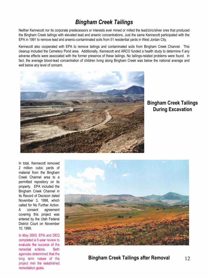
Bingham Creek TailingsNeither Kennecott nor its corporate predecessors or interests ever mined or milled the lead/zinc/silver ores that produced the Bingham Creek tailings with elevated lead and arsenic concentrations. Just the same Kennecott participated with the EPA in 1991 to remove lead and arsenic-contaminated soils from 51 residential yards in West Jordan City.
Kennecott also cooperated with EPA to remove tailings and contaminated soils from Bingham Creek Channel. This cleanup included the Cemetery Pond area. Additionally, Kennecott and ARCO funded a health study to determine if any adverse effects were associated with the former presence of these tailings. No tailings-related problems were found. In fact, the average blood-lead concentration of children living along Bingham Creek was below the national average and well below any level of concern.
Bingham Creek Tailings During Excavation
In total, Kennecott removed 2 million cubic yards of material from the Bingham Creek Channel area to a permitted repository on its property. EPA included the Bingham Creek Channel in its Record of Decision dated November 3, 1998, which called for No Further Action. A consent agreement covering this project was entered by the Utah Federal District Court on November 10, 1999.
In May 2003, EPA and DEQ completed a 5-year review to evaluate the success of the remedial actions. Both agencies determined that the long term nature of the project met the established remediation goals.
Bingham Creek Tailings after Removal

13
Small Bingham Reservoir
In 1991, the Small Bingham Reservoir was placed in service following removal of 1.8 million cubic yards of contaminated sludge and soils from the reservoir site. Construction of the Small Bingham Reservoir allowed Kennecott to discontinue use of the old Bingham Reservoir. That reservoir, built in 1965, was taken out of service so the underlying sediments and sludges could be removed prior to constructing the Large Bingham Reservoir. The small reservoir utilizes a triple layer (two clay plus one synthetic) liner system with leak detection and a groundwater monitoring system. The Small Bingham Reservoir is operated under a State of Utah groundwater discharge permit and was initially used as a surge basin for excess leach water. With the cessation of leaching operations, the small reservoir is used in tandem with the Large Bingham Reservoir to manage meteoric flows and draindown from the waste dumps.
Large Bingham Reservoir Before Reclamation
Once the Small Bingham Creek Reservoir was in place, Kennecott drained the old Bingham Reservoir and removed 4 million tons of waste, including sludges, tailings, and acidic soils from beneath the reservoir. The sludge removal was completed with EPA oversight. Kennecott also removed waste rock from the foundation of an old dam and voluntarily conducted a waste rock reclamation demonstration project on 600 acres. That work resulted in Kennecott being honored with an Earth Day Award from the Utah Division of Oil, Gas and Mining.

14
Large Bingham Reservoir After Reclamation
Following removal of contaminated materials, Kennecott reconstructed the reservoir for storm water management and storage of process water during upset conditions. The new reservoir is divided into three operating zones, with sophisticated lining systems installed in the two zones that are designed for storage of water. The third zone is a sedimentation basin designed to remove silt and debris residue from the water prior to entering the storage zones. It is also lined. The large reservoir utilizes leak detection and groundwater monitoring systems and is operated under a Utah Ground Water Discharge Permit. The project was completed in 1994.
EPA included the Large Bingham Reservoir, as well as the Bingham Creek Channel, in its Record of Decision dated November 3, 1998. The U.S. District Court in Utah entered a consent agreement covering this project on November 10, 1999.
15
RECLAMATION DEMONSTRATION PROJECT
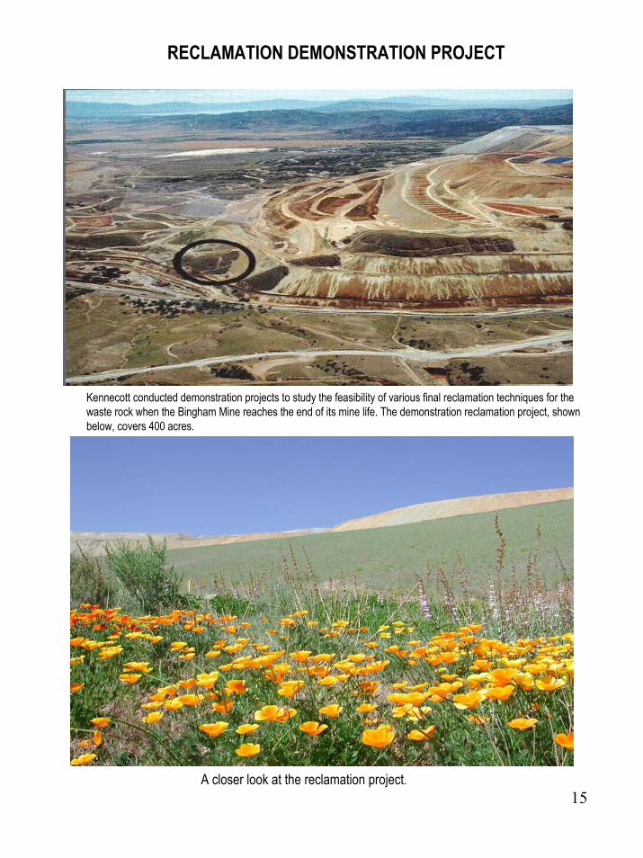
Kennecott conducted demonstration projects to study the feasibility of various final reclamation techniques for the waste rock when the Bingham Mine reaches the end of its mine life. The demonstration reclamation project, shown below, covers 400 acres.
A closer look at the reclamation project.

16
Eastside Water Collection System and Bingham Canyon Drainage Cutoff
Eastside Leach Water Collection Cutoff Walls During Construction
Kennecott has completed improvements to surface and groundwater cutoff structures in 28 drainages along the foothills of the Oquirrh Mountains. The cutoff walls are covered under a groundwater discharge permit issued by the Utah Division of Water Quality.
The Eastside Collection System captures water from precipitation and storm events falling on Bingham Mine waste rock disposal areas and lower Bingham Canyon. The system, composed of French drains and impermeable cutoff walls keyed into bedrock, captures surface and alluvial leach and storm water and includes upgraded leach and storm water conveyance systems. The system is operated under a State of Utah groundwater discharge permit.
In 1999, Kennecott initiated a program to cease active leaching of the waste rock areas. The company ultimately ceased active leaching in the fall of 2000.
Completed Cutoff Wall
17
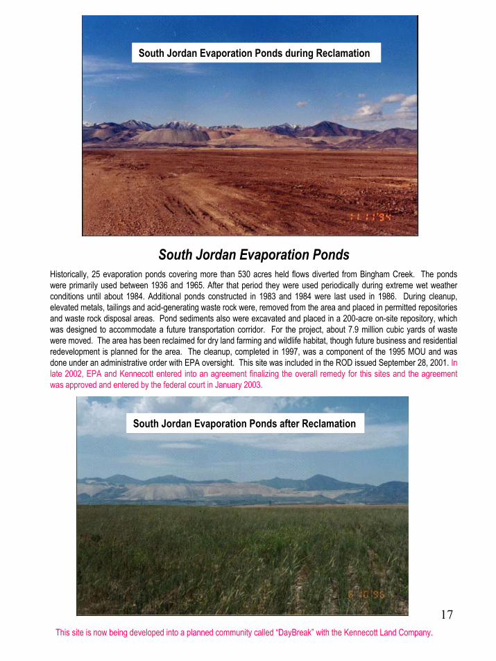
South Jordan Evaporation Ponds during Reclamation
South Jordan Evaporation PondsHistorically, 25 evaporation ponds covering more than 530 acres held flows diverted from Bingham Creek. The ponds were primarily used between 1936 and 1965. After that period they were used periodically during extreme wet weather conditions until about 1984. Additional ponds constructed in 1983 and 1984 were last used in 1986. During cleanup, elevated metals, tailings and acid-generating waste rock were, removed from the area and placed in permitted repositories and waste rock disposal areas. Pond sediments also were excavated and placed in a 200-acre on-site repository, which was designed to accommodate a future transportation corridor. For the project, about 7.9 million cubic yards of waste were moved. The area has been reclaimed for dry land farming and wildlife habitat, though future business and residential redevelopment is planned for the area. The cleanup, completed in 1997, was a component of the 1995 MOU and was done under an administrative order with EPA oversight. This site was included in the ROD issued September 28, 2001. In late 2002, EPA and Kennecott entered into an agreement finalizing the overall remedy for this sites and the agreement was approved and entered by the federal court in January 2003.
South Jordan Evaporation Ponds after Reclamation
This site is now being developed into a planned community called “DayBreak” with the Kennecott Land Company.
18
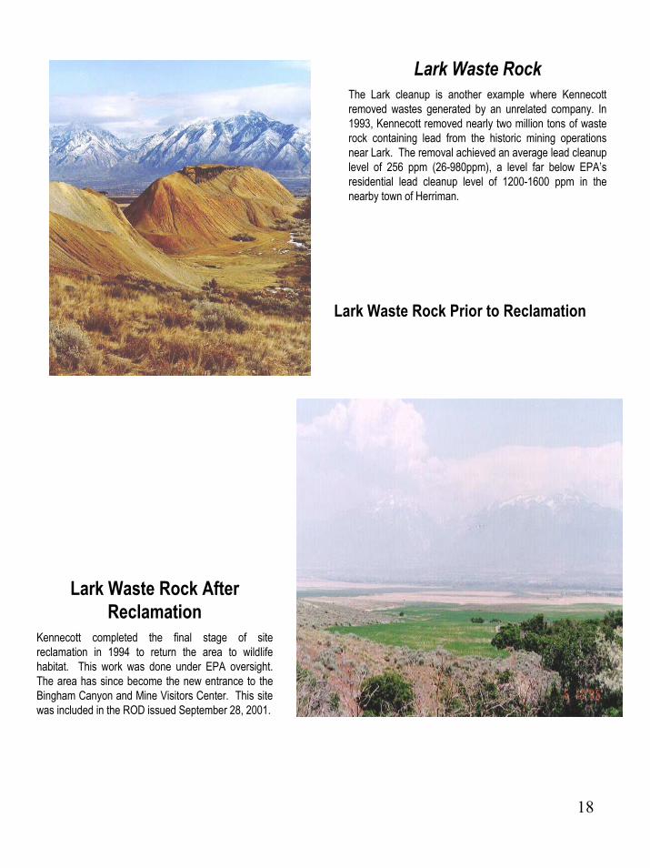
Lark Waste RockThe Lark cleanup is another example where Kennecott removed wastes generated by an unrelated company. In 1993, Kennecott removed nearly two million tons of waste rock containing lead from the historic mining operations near Lark. The removal achieved an average lead cleanup level of 256 ppm (26-980ppm), a level far below EPA’s residential lead cleanup level of 1200-1600 ppm in the nearby town of Herriman.
Lark Waste Rock Prior to Reclamation
Lark Waste Rock After Reclamation
Kennecott completed the final stage of site reclamation in 1994 to return the area to wildlife habitat. This work was done under EPA oversight. The area has since become the new entrance to the Bingham Canyon and Mine Visitors Center. This site was included in the ROD issued September 28, 2001.

19
Lark Tailings, aka State Motorcycle Park Tailings
Lark Tailings Prior to
Reclamation
Kennecott completed the removal of 45,000 cubic yards of elevated lead and arsenic tailings “hot spots” from the State Motorcycle Park in 1993. The material was removed to an engineered repository at the wasterock dumps. Kennecott then covered the remaining 600 acres of low-lead and arsenic-bearing tailings with a soil cap. The company also cleaned up a small natural seep and reconstructed it into a wetlands treatment pilot study site. Final site reclamation to restore the area as wildlife habitat was completed in 1994. Kennecott received an Earth Day Award for this work from the Utah Division of Oil, Gas and Mining. This site was included in the ROD issued September 28, 2001.
Lark Tailings (State Motorcycle Park) after Soil Cap and Seeding

20
Butterfield Waste RockIn 1993, Kennecott removed 1.1 million tons of waste rock from the historical (non-Kennecott) Butterfield drainage tunnel construction.
BUTTERFIELD WASTE ROCK AFTER RECLAMATION
The waste rock was relocated to an engineered repository in the Bingham waste- rock dumps and the removal site was reclaimed for recreational use and wildlife habitat. This work was completed in 1994 with EPA oversight and received an Earth Day Award from the Utah Division of Oil, Gas and Mining. This site was included in the ROD issued September 28, 2001.
21
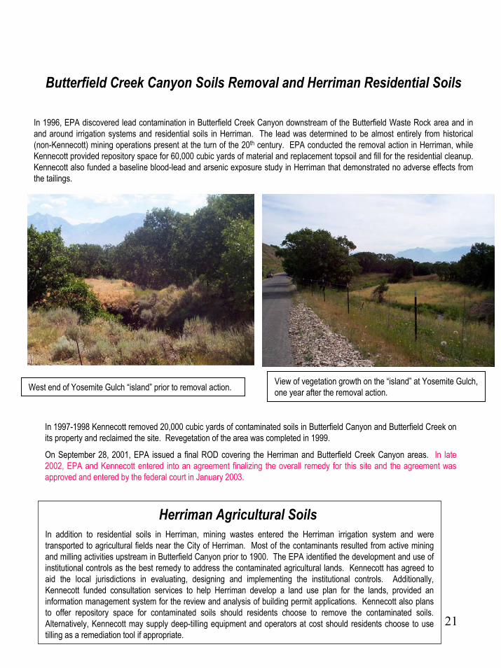
Butterfield Creek Canyon Soils Removal and Herriman Residential Soils
In 1996, EPA discovered lead contamination in Butterfield Creek Canyon downstream of the Butterfield Waste Rock area and in and around irrigation systems and residential soils in Herriman. The lead was determined to be almost entirely from historical (non-Kennecott) mining operations present at the turn of the 20th century. EPA conducted the removal action in Herriman, while Kennecott provided repository space for 60,000 cubic yards of material and replacement topsoil and fill for the residential cleanup. Kennecott also funded a baseline blood-lead and arsenic exposure study in Herriman that demonstrated no adverse effects from the tailings.
View of vegetation growth on the “island” at Yosemite Gulch, one year after the removal action. West end of Yosemite Gulch “island” prior to removal action.
In 1997-1998 Kennecott removed 20,000 cubic yards of contaminated soils in Butterfield Canyon and Butterfield Creek on its property and reclaimed the site. Revegetation of the area was completed in 1999.
On September 28, 2001, EPA issued a final ROD covering the Herriman and Butterfield Creek Canyon areas. In late 2002, EPA and Kennecott entered into an agreement finalizing the overall remedy for this site and the agreement was approved and entered by the federal court in January 2003.
Herriman Agricultural SoilsIn addition to residential soils in Herriman, mining wastes entered the Herriman irrigation system and were transported to agricultural fields near the City of Herriman. Most of the contaminants resulted from active mining and milling activities upstream in Butterfield Canyon prior to 1900. The EPA identified the development and use of institutional controls as the best remedy to address the contaminated agricultural lands. Kennecott has agreed to aid the local jurisdictions in evaluating, designing and implementing the institutional controls. Additionally, Kennecott funded consultation services to help Herriman develop a land use plan for the lands, provided an information management system for the review and analysis of building permit applications. Kennecott also plans to offer repository space for contaminated soils should residents choose to remove the contaminated soils. Alternatively, Kennecott may supply deep-tilling equipment and operators at cost should residents choose to use tilling as a remediation tool if appropriate.

22
North Facilities Sites
The North End of Kennecott’s operations consists of the wastewater treatment plant sludge ponds and 33 soils sites that have been identified for remediation over the course of Kennecott’s Environmental Remediation Program. Much of the cleanup work is being conducted under the administrative order on consent (AOC) for the North Facilities Soils and Wastewater Treatment Plant Sludge Ponds Removal. Similar to the South End Cleanup, Kennecott has worked closely with local communities and held numerous meetings and tours for interested parties.
As part of the Remedial Investigation and Feasibility Study (RI/FS), Kennecott is studying historic groundwater contamination at the smelter and refinery facilities. Contamination sources have been identified and have either been eliminated or are in the process of being addressed.
One such area involves the capturing of selenium-contaminated groundwater that originates at the refinery and surfaces via artesian flows at nearby wetlands. In 1998 the company completed an ecological risk assessment of this area that identified some risk from selenium toxicity to sensitive avian wildlife. To minimize risk to the wetlands and wildlife, the artesian flows are being captured and recycled to Kennecott’s water system for use in its operations. At the same time, Kennecott is in the process of designing habitat restoration plans for the area. Those plans call for removal of some additional contaminated soils and creating improved wetlands habitat.
Kennecott also is evaluating innovative and effective means to treat and eliminate selenium contamination in surface and groundwater.
EPA issued a ROD for the KUCC North Facilities Sites on September 26, 2002 that was also co-signed by the State of Utah.

23
Smelter FootprintConcentrate and soils contaminated with highly elevated levels of metals have been recycled to recover metals. Other contaminated soils previously removed from the area were disposed of at permitted repositories. The Noranda smelter demolition has been completed, and additional soils removal is nearly complete as part of the work under the North Facilities/Waste Water Treatment Plant Sludge Ponds administrative order with EPA. The area is subject to a State of Utah groundwater discharge permit obtained for the smelter modernization.
24
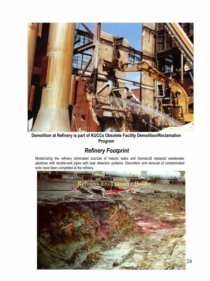
Demolition at Refinery is part of KUCCs Obsolete Facility Demolition/Reclamation Program
Refinery FootprintModernizing the refinery eliminated sources of historic leaks and Kennecott replaced wastewater pipelines with double-wall pipes with leak detection systems. Demolition and removal of contaminated soils have been completed at the refinery.
Refinery Excavation - Before
25
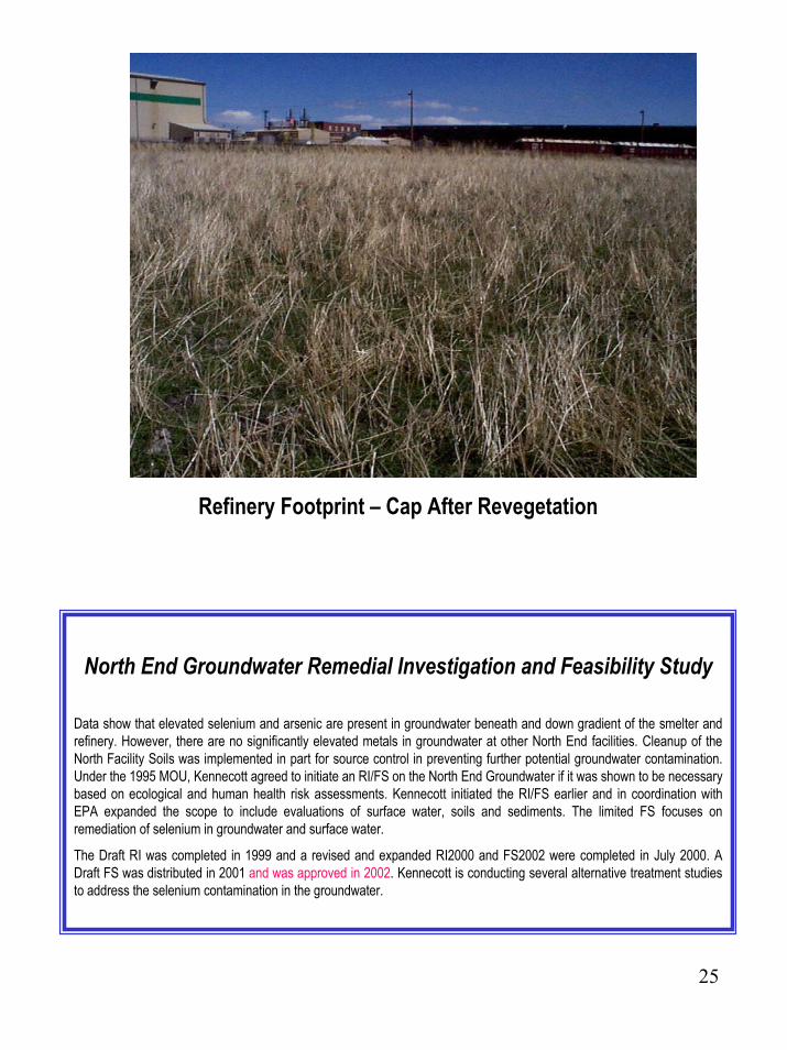
Refinery Footprint – Cap After Revegetation
North End Groundwater Remedial Investigation and Feasibility Study
Data show that elevated selenium and arsenic are present in groundwater beneath and down gradient of the smelter and refinery. However, there are no significantly elevated metals in groundwater at other North End facilities. Cleanup of the North Facility Soils was implemented in part for source control in preventing further potential groundwater contamination. Under the 1995 MOU, Kennecott agreed to initiate an RI/FS on the North End Groundwater if it was shown to be necessary based on ecological and human health risk assessments. Kennecott initiated the RI/FS earlier and in coordination with EPA expanded the scope to include evaluations of surface water, soils and sediments. The limited FS focuses on remediation of selenium in groundwater and surface water.
The Draft RI was completed in 1999 and a revised and expanded RI2000 and FS2002 were completed in July 2000. A Draft FS was distributed in 2001 and was approved in 2002. Kennecott is conducting several alternative treatment studies to address the selenium contamination in the groundwater.
26
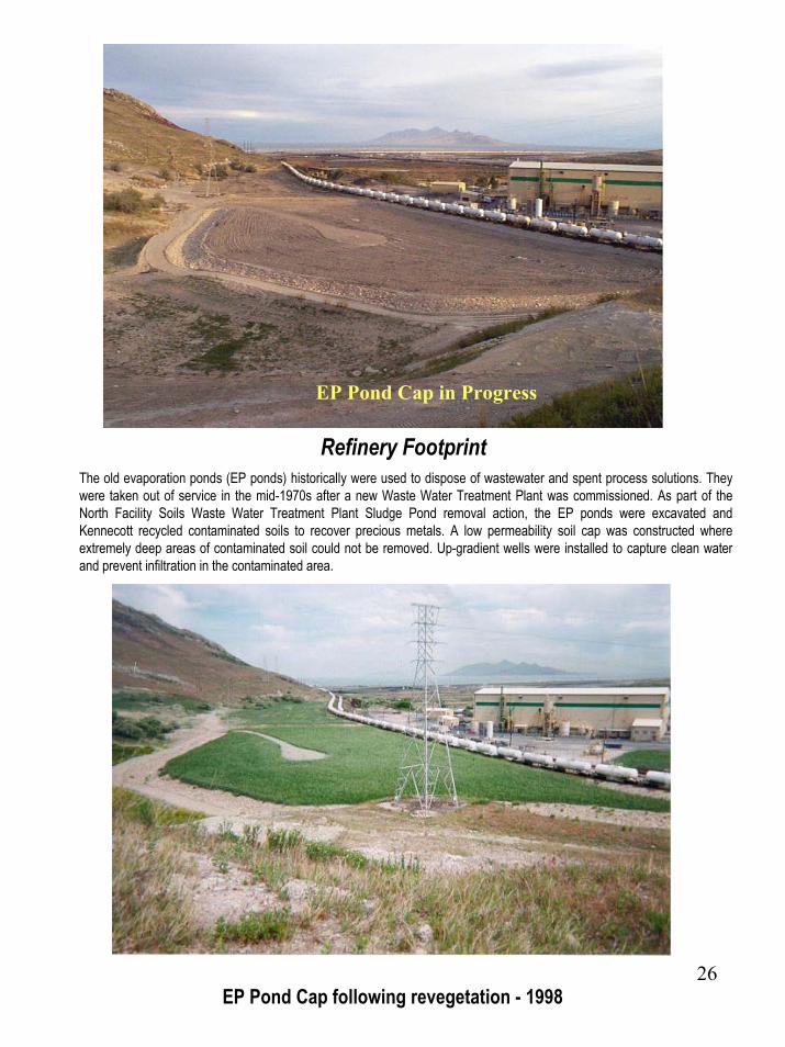
EP Pond Cap in Progress
Refinery FootprintThe old evaporation ponds (EP ponds) historically were used to dispose of wastewater and spent process solutions. They were taken out of service in the mid-1970s after a new Waste Water Treatment Plant was commissioned. As part of the North Facility Soils Waste Water Treatment Plant Sludge Pond removal action, the EP ponds were excavated and Kennecott recycled contaminated soils to recover precious metals. A low permeability soil cap was constructed where extremely deep areas of contaminated soil could not be removed. Up-gradient wells were installed to capture clean water and prevent infiltration in the contaminated area.
EP Pond Cap following revegetation - 1998
27
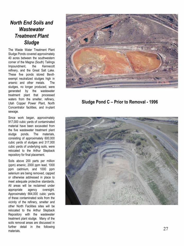
North End Soils and Wastewater
Treatment Plant Sludge
The Waste Water Treatment Plant Sludge Ponds covered approximately 40 acres between the southwestern corner of the Magna (South) Tailings Impoundment, the Kennecott refinery, and the Great Salt Lake. These five ponds stored Bevill-exempt neutralized sludges high in arsenic and other metals. The sludges, no longer produced, were generated by the wastewater treatment plant that processed waters from the smelter, refinery, Utah Copper Power Plant, North Concentrator facilities, and in-plant sewage.
Since work began, approximately 917,000 cubic yards of contaminated material have been excavated from the five wastewater treatment plant sludge ponds. The materials, consisting of approximately 600,000 cubic yards of sludges and 317,000 cubic yards of underlying soils, were relocated to the Arthur Stepbackrepository for final placement.
Soils above 200 parts per million (ppm) arsenic, 2000 ppm lead, 1000ppm cadmium, and 1000 ppmselenium are being removed, capped or otherwise addressed in place to meet adequate protective standards. All areas will be reclaimed under appropriate agency oversight. Approximately 664,000 cubic yards of these contaminated soils from the vicinity of the refinery, smelter and other North Facilities sites will be relocated to the Arthur StepbackRepository with the wastewater treatment plant sludge. Many of the soils removal areas are discussed in further detail in the following materials.
Sludge Pond C – Prior to Removal - 1996
28
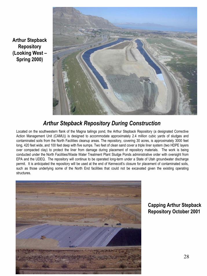
Arthur Stepback Repository
(Looking West –Spring 2000)
Arthur Stepback Repository During ConstructionLocated on the southwestern flank of the Magna tailings pond, the Arthur Stepback Repository (a designated Corrective Action Management Unit (CAMU)) is designed to accommodate approximately 2.4 million cubic yards of sludges and contaminated soils from the North Facilities cleanup areas. The repository, covering 30 acres, is approximately 3000 feet long, 420 feet wide, and 100 feet deep with five sumps. Two feet of clean sand cover a triple liner system (two HDPE layers over compacted clay) to protect the liner from damage during placement of repository materials. The work is being conducted under the North Facilities/Waste Water Treatment Plant Sludge Ponds administrative order with oversight from EPA and the UDEQ. The repository will continue to be operated long-term under a State of Utah groundwater discharge permit. It is anticipated the repository will be used at the end of Kennecott’s closure for placement of contaminated soils, such as those underlying some of the North End facilities that could not be excavated given the existing operating structures.
Capping Arthur Stepback Repository October 2001

29
Smelter Slag LagoonThe Smelter Slag Lagoon holds excess water supply for use in process and excess storm waters from Kessler Canyon. The water is sent to the process water system or is routed to a permitted discharge location. The water quality is generally good. While Slag Lagoon sediments contained elevated concentrations of certain metals, the concentrations were not a risk to humans. However, they did present a potential risk to sensitive wetland species. As a result, during the summer of 2001 the lagoon was drained and contaminated sediments were removed to the Arthur Stepback Repository.
Approximately 347,000 cubic yards (99,400 from the Hazelton Area and 247,550 cubic yards from Slag Lagoon) of contaminated soil containing arsenic, and /or lead above the action levels were excavated and removed from the site and hauled to the Arthur Step Back Repository for disposal. In a portion of the site (Hazelton), elevated concentrations of lead and /or arsenic remain after a two-to-four feet removal of soil. The remaining soils were covered with approximately 35,000 cubic yards of fill material that provided a minimum cover of 18 inches. None of the contaminated soil left in place failed the toxicity characteristic limits using SPLP analysis.
The Slag Lagoon Area was divided into two sections: the first section is approximately 12 acres and is used as a freshwater supply holding pond for operations. The second section has been reclaimed with shoreline, islands, and wetland plantings. This section also has been incorporated with the I-80 Pond Site by removing the earthen dike that once separated the two sites.
Beginning Slag Lagoon Removal 2001
Slag Lagoon After Draining
Waterfowl Using the Restored Slag Lagoon after Removal – January 2001

30
I-80 Pond
Approximately 182,303 cubic yards (291,684 tons) of contaminated soil containing elevated levels of arsenic and lead were removed from a location referred to as the I-80 Pond, given its proximity to Interstate Highway 80. Excavation and removal of the contaminated soil were completed during May 2001 and all soils disposed of in the Arthur Stepback Repository.
An area with elevated arsenic sediment along the north boundary (along Interstate 80) of the Site was capped due to the proximity of a surface transcontinental communication line. This line is a lead cased line installed during the 1950s and is in a fragile condition. This area is approximately 4,500 feet by 20 feet and was capped with a minimum of 18 inches of local clean borrow.
Once the removal of contaminated soils and subsequent capping were complete, the excavation sidewalls were sloped and fifteen small 20 feet by 20 feet islands were constructed. During October and November of 2001, native wetland plants were planted along all shorelines that did not have established phragmite colonies. During the removal of the Slag Lagoon Soils, the earthen dike that separated the two sites was removed and a culvert that flows under Interstate 80 into the Great Salt Lake was opened. The site is currently considered closed, but water level management is taking place.
I-80 Pond after Draining – Prior to Removal

31
Lower Kessler CanyonIn 1991, all stockpiled flue dust was removed from lower Kessler Canyon to a state-permitted off-site treatment, storage and disposal facility.
Approximately 161,000 cubic yards of contaminated soil containing elevated levels of arsenic and lead were removed from the site during the fall of 2000 through spring of 2001 and disposed of in the Arthur Stepback Repository. Soils were not removed from some areas still in operational use at the smelter. In some areas soils were only removed from the top two-to-five feet and the remaining soil was sampled and capped. None of the post removal samples that represent these areas failed SPLP analysis for the TC limit. The Site wasrecontoured and seeded.

32
No Further Action Required
Diving Board Area TailingsThe “Diving Board Area Tailings” located on approximately 21 acres across Highway 201 from the southwest corner of the Magna Tailings Impoundment consisted of tailings that accumulated during main pump shutdowns. The tailings material was essentially the same material composition as Kennecott’s tailings in the Magna Tailings Impoundment, consisting of low concentrations of lead and arsenic (no health hazards). Kennecott relocated 363,000 cubic yards (500,000 tons) of tailings material to the Magna tailings impoundment for dike construction. The site was reclaimed and a portion of the area is now permitted under a State of Utah Groundwater Discharge Permit. No further action is required.
Magna SoilsThe town of Magna, located in western Salt Lake County, lies east and southeast of Kennecott’s operations. Kennecott and EPA investigated potential effects of historical smelter emissions and tailings impoundment dust in the vicinity of the town of Magna. Additionally, EPA sampling showed no elevated metals levels; likewise, State of Utah testing revealed no metals above commonly used action levels. Health studies funded by Kennecott and conducted by the Salt Lake City/County Health Department and University of Cincinnati found no exposure concerns from mining wastes. The Agency for Toxic Substances and Disease Registry (ATSDR) also concluded that no health risk is attributed to Magna soils. In light of the results of the health studies and the sampling results, EPA recommended no further action by letter dated October 28, 1994.
Power PlantThe existing Kennecott Utah Copper industrial power plant began operating in 1943. The plant is permitted to burn coal during the months of March to October and utilizes natural gas for fuel if it operates during the winter months. In 1987, the State of Utah and the Salt Lake City/County Health Department investigated the disposition of wastes from the plant and found no evidence of environmental concerns.
Smelter Slag PileThe Smelter Slag Pile consisting of non-hazardous slag from the old reverberatory smelters was historically recovered for rail ballast and construction purposes. Concentrate, flux and other material stockpiles were removed from the top of the slag pile and the remaining slag has been used as drain blanket material in embankment of the North tailings impoundment expansion. When the remaining slag is finally removed the site will be reclaimed or utilized for industrial operations or other development.
Upper Kessler Canyon DrainageHistorically, a series of smelters was located at the mouth of Kessler Canyon. Studies suggested elevated metals in surface soils due to air emissions from historic smelters and storage of process materials. The metals do not appear to be mobile, though some hot spots have been identified and removed. A major reclamation program has been under way since the 1970s to restore native vegetation in the canyon. The ecological risk assessment indicates plant and animal communities are rapidly recovering from past smelter effects.

33
Other Major Kennecott Environmental InitiativesFACILITIES
Modernized Smelter and Refinery• 1 billion investment• Doubles smelting capacity• Cleanest copper smelter in the world• 95 percent sulfur dioxide emission reduction (99.9 percent sulfur capture)• State-of-the-art pollution prevention/control technology• Major reduction in emissions from hazardous air pollutants • Generates 60 percent of its own power needs through waste heat recovery• Dramatically reduces hazardous waste stream volume through resource recovery
Expanded and upgraded tailings impoundment• $ 500 million investment • Increased storage capacity and seismic stability components• Inland Sea Shorebird Reserve – 2,500-acre wetlands mitigation site
Materials storage building with ground water protection and air pollution control equipmentAll PCBs have been eliminatedAll underground tanks have been eliminatedAsbestos elimination program at 95% of KUCC’s facilities Demolition and reclamation of obsolete facilitiesEliminate sulfur dioxide storage tank as part of process at refinery and replace with sodium bi-sulfite –significantly reduce or eliminate risk to employees or nearby community from catastrophic SO2 releases
PROGRAMSPollution prevention/waste minimization programHealth, Safety and Environmental audit programEnvironmental Awareness and Compliance training program at all facilitiesClimate Change Program initiated in 2002Sustainable Development Program initiated in 2002
WATER MANAGEMENTFacility-wide water management system, with continual improvements being studied and implementedSite-specific selenium studies for the Great Salt LakeInnovative water treatment technology design and implementation
WILDLIFEWetlands mitigation bank – 1,196 acres Neotropical bird survey siteVegetation Survey conducted by Nature ConservancyElk transplant programSite-wide ecological risk assessmentsBio-Diversity Studies
RECLAMATION & LAND MANAGEMENTInnovative reclamation studiesEnvironmental geochemistry studiesLong-term land use planning