karst topography model written section 2.4
TRANSCRIPT
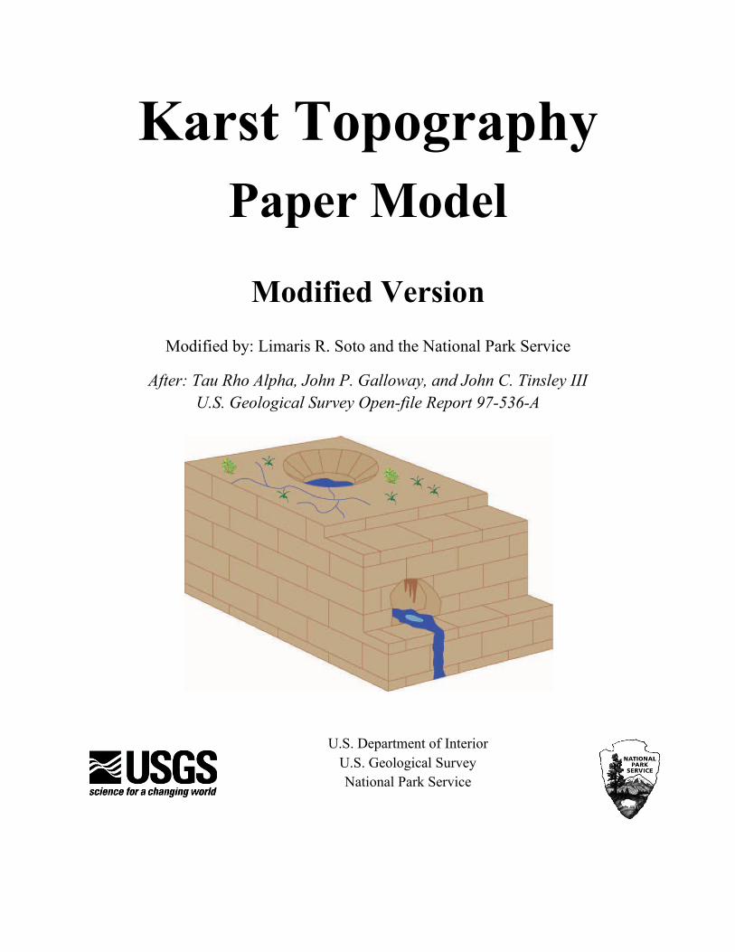
Karst Topography Paper Model
Modified Version Modified by: Limaris R. Soto and the National Park Service
After: Tau Rho Alpha, John P. Galloway, and John C. Tinsley III U.S. Geological Survey Open-file Report 97-536-A
U.S. Department of Interior U.S. Geological Survey National Park Service

This report has been modified from the U.S. Geological Survey Open-file Report 97-536-A “Karst Topography Computer animations and paper model”. The original report was created in 1997, and included the paper model and a floppy disk or diskette version. Because the paper model continues to be a great example of karst topography, we decided to modify and update the report and omit the diskette version of the document.
This report is preliminary and has not been reviewed for conformity with the National Park Service and editorial standards. Any use of trade, firm, or product names is for descriptive purposes only and does not imply endorsement by the U.S. Government.
Although this program has been used by the U.S. Geological Survey, and the National Park Service, no warranty, expressed or implied, is made by the USGS and NPS as to the accuracy of the program and related program material, nor shall the fact of distribution constitute any such warranty, and no responsibility is assumed by the USGS, and NPS in connection therewith.
U.S. Geological Survey Menlo Park, CA 94025
National Park Service Geologic Resources
Division Lakewood, CO 80225
2

Description of the Report
Karst describes a distinctive topography that indicates dissolution. Karst terrains are characterized by the presence of caves, sinkholes, sinking streams, and springs. Understanding caves and karst is important, because as much as a quarter of the world’s population depends upon fresh water supplied from karst areas. In addition, karst systems are vulnerable to ground-water contamination, affecting waters and the dependent wildlife in karst areas.
This report illustrates, through a paper model, why caves develop in limestone. By studying the paper model, students will better understand the evolution of karst topography.
Included in the report are templates for making a paper model, instructions for its assembly, and a discussion of the development of karst topography.
The date of this PDF document is 2/26/14.
For additional information contact; National Park Service Natural Resource Stewardship & Science Geologic Resources Division P.O. Box 25287 Denver, Colorado 80225-0287 NPS Geologic Resources Division
3
KARST – Introduction
Throughout the world karst landscapes vary from rolling hills dotted with sinkholes, as found in portions of the central United States, to jagged hills and pinnacle karst found in the tropics. The development of all karst landforms requires the presence of rock which is capable of being dissolved by surface water or groundwater.
The term karst describes a distinctive topography that indicates dissolution (also called chemical solution) of underlying soluble rocks by surface water or groundwater. Although commonly associated with carbonate rocks (limestone and dolomite) other highly soluble rocks such as evaporates (gypsum and rock salt) can be sculpted into karst terrain.
Understanding caves and karst is important because ten percent of the Earth’s surface is occupied by karst landscape and as much as a quarter of the world’s population depends upon water supplied from karst areas. Though most abundant in humid regions where carbonate rock is present, karst terrain occurs in temperate, tropical, alpine and polar environments. Karst features range in scale from microscopic (chemical precipitates) to entire drainage systems and ecosystems which cover hundreds of square miles and broad karst plateaus.
Although karst processes sculpt beautiful landscapes, karst systems are very vulnerable to ground water pollution due to the relatively rapid rate of water flow and the lack of a natural filtration system. This puts local drinking water supplies at risk of being contaminated. In the mid of the 1980’s, flooding of caves in the highly populated area of Bowling Green Kentucky, caused industrial waste to leak into the vast system of underground fissures polluting the groundwater in local wells. Due to urban expansion millions of dollars are spent annually in the United States to repair damage to roads, buildings, and other structures which are built on unstable karst features.
Karst Topography
The degree of development of karst landforms varies greatly from region to region. Large drainage systems in karst areas are likely to have both fluvial (surface) and karst (underground) drainage components. As stated in the introduction, the term karst describes a distinctive topography that indicates dissolution of underlying rocks by surface water or groundwater.
Water falls as rain or snow and soaks into the soil. The water becomes weakly acidic because it reacts chemically with carbon dioxide that occurs naturally in the atmosphere and the soil. This acid is named carbonic acid and is the same compound that makes carbonated beverages taste tangy. Rainwater seeps downward through the soil and through fractures in the rock responding to the force of gravity. The carbonic acid in the moving groundwater dissolves the bedrock along the surfaces of joints, fractures, and bedding planes, eventually forming cave passages and caverns.
4

Limestone is a sedimentary rock consisting primarily of calcium carbonate in the form of mineral calcite. Rainwater dissolves the limestone by the following reaction:
Calcite + Carbonic acid = Calcium ions dissolved in groundwater + Bicarbonate ions dissolved in groundwater
Cracks and joints that interconnect in the soil and bedrock allow the water to reach a zone below the surface of the land where all the fractures and void spaces are completely filled (also known as saturated) with water. This water-rich zone is called the saturated zone and its upper surface is called the water table. The volume of void space (space filled with air or water) in soil or bedrock is termed porosity. The larger the proportion of voids in a given volume of soil or rock the greater the porosity. When these voids are interconnected, water or air (or other fluids) can migrate from void to void. Thus the soil or bedrock is said to be permeable because fluids (air and water) can easily move through them. Permeable bedrock makes a good aquifer, a rock layer that holds and conducts water. If the groundwater that flows through the underlying permeable bedrock is acidic and the bedrock is soluble, a distinctive type of topography, karst topography, can be created.
In tropical areas with thick massive limestone, a remarkable and distinctive landscape of jagged hills and narrow gorges completely dominates the landscape. Movement of solution along fractures and joints etches the bedrock and leaves limestone blocks as isolated spires or pinnacles. Pinnacles range from small features a few inches tall to intermediate forms a few feet tall to large pinnacles hundreds of feet tall. Besides the etching of pinnacles and residual hills, sheets of flowing water move down sloping surfaces creating a variety of etched surface features. Examples of dominant landforms, such as pinnacles, cones, and towers, are commonly found in the tropical karst environment of northern Puerto Rico.
The paper model represents another type of karst landscape, that of a rolling limestone plain such as is found in south-central Kentucky, northern Florida, and the Highland Rim of central Tennessee where doline karst is the dominate feature. Doline karst is the most widely distributes type of karst landscape. The landscape is dotted with sinkholes (dolines) which can vary widely in number and size. For the Sinkhole Plain in central Kentucky, there are approximately 5.4 sinkholes per square kilometer over a 153 square kilometer area. For north Florida there are almost 8 sinkholes per square kilometer over a 427 kilometer area (White 1988).
Karst topography dominated by sinkholes or dolines usually has several distinct surface features. The paper model shows features normally associated with karst topography. Sinkholes (also known as dolines) are surface depressions formed by either: 1) the dissolution of bedrock forming a bowl-shaped depression, or 2) the collapse of shallow caves that were formed by dissolution of the bedrock. These sinkholes or shallow basins may fill with water forming lakes or ponds. Springs are locations where groundwater emerges at the surface of the earth. Sinking streams are streams which terminate abruptly by flowing or seeping into the ground. Sinking
5

streams are evidence of disrupted surface drainage and thus indicate the presence of an underground drainage system.
Underground Features in Karst Regions Much of the drainage in karst areas occurs underground rather than as surface runoff. As rainwater seeps into the ground along bedding planes or fractures in bedrock, the acidic water dissolves any limestone in comes into contact. If the dissolution of bedrock continues, a large underground cavity can form. By one definition, if the cavity is large enough for a person to enter, and if it extends beyond daylight, it is called a cave. Caves may have a complex underground drainage system composed of a continuous sequence of conduits (passages) and smaller openings in the bedrock. A cave can be very small, yet occasionally caves may widen into huge subterranean galleries having many miles of passages. The exploration of caves either for scientific purposes of for fun is known as speleology. There are many extensive cave systems in the work, below is a short list of the longest caves found in the United States.
Brief list of the longest caves in the Unites States*
Cave Name
Location
Length (meters)
Length (miles)
Mammoth Cave National Park Kentucky 663,050 412.000
Jewel Cave National Monument South Dakota 335,564 208.510
Wind Cave National Park South Dakota 248,161 154.200
Lechuguilla Cave (Carlsbad Caverns National Park)
New Mexico 242,045 150.400
Fisher Ridge Cave System Kentucky 209,216 130.001
Friars Hole Cave System West Virginia 75,655 47.010
Data obtained from Bob Gulden Longest caves in the USA (accessed 4 February 2021) *This list changes constantly as more passages are explored. Please go to the website for the latest data.
What do Caves Contain? Moving water may transport earth materials into and through caves physically or chemically. Caves contain interesting features as a result of the physical and chemical processes that forms them. Among these features are breakdown blocks of rocks formed by collapse of cave ceilings. Also seen are sediments containing boulders, sand, silt, and clay deposited from water flowing in and through cave passages and conduits. Speleogens are irregular or distinctive shapes of carbonate rock etched from bedrock by dripping or running water. Speleogens can form where bedrock is not uniform in chemical composition. Consequently, the less soluble rock dissolves
6
slower than adjacent more soluble rock through time. The less soluble rock tends to stand in relief and projects from walls and ceilings of caves.
Away from their entrances, caves usually provide a relatively constant temperatures and humidity over a long period of time. Thus, caves provide an ideal environment for chemical deposition of minerals. As water laden with dissolved carbonate seeps into the air-filled cave passage, it may lose excess carbon dioxide to the cave atmosphere, or the water itself may evaporate, causing the dripwater to precipitate secondary carbonate or other minerals from solution, creating cave formations or speleothems including cone-shaped stalactites, stalagmites, flowstone or rimstone, or other interesting shapes. Caves in karst areas often have stalactites (icicle-like masses of chemical limestone) that hang from cave ceilings and stout stalagmites protruding from the cave floor. Stalactites and stalagmites can be a few inches to several feet long, many lengthen and join to form columns. Sometimes the drip water will flow down the walls and over the cave floor creating flowstone or rimstone deposits. Where drip water seeps from a joint and then drips over the edges of ledges, deposits of great complexity known as draperies are formed. The color of dripstones and flowstones comes from organic and/or iron oxide compounds brought in from the surface, giving the speleothems an orange brown color or from the presence of oxides and hydroxides or iron and manganese which give the speleothems a deep brown or black color.
Deposits preserved in caves can tell geologist about past climates. Fossils and artifacts found in caves help geologists and archeologists unravel the prehistory of an area. Furthermore, caves support a unique community of bacteria, fungi and animals not seen on the surface of the Earth.
What Lives Underground? Some scientists are interested in cave ecology and how cave animals interact with cave microclimates. Animals found in caves include everything from surface dwelling animals like raccoons that occasionally use the cave, to animals that have adapted exclusively to life in the cave (troglobites). Troglobites cannot survive outside caves. These may include such diverse animals as eyeless fish and crayfish, cave beetles, flatworms, and other unusual types of insects. Although the cave environment appears to be stable, change can and does occur. The temperatures of the cave varies due to air movement near the entrances and the temperatures of water entering the cave. In fact, some caves have their own weather systems which created wind due to temperatures and pressure differences between the entrance and interior passageways.
Many animals, such as bats, crickets, and pack rats, regularly visit, raise their young, or hibernate in caves. These animals are called trogloxenes. Caves may support large numbers of different types of bats. Bats may be among the most beneficial animals to people and the ecosystem as insect-eaters and plant pollinators. The little brown bat can eat 600 mosquitoes in an hour thus performing the work of a “natural insecticide”, helping control crop pests and other insects. The Mammoth Cave System in Kentucky, which is the most extensive cave system in the world, has
7

currently 41 species of cave-adapted organisms. This number means that the park has one of the highest subterranean biodiversities worldwide. In 1981, the United Nations designated Mammoth Cave National Park as a World Heritage Site. An excellent summary of the Mammoth Cave area and other caves found in the U.S. National Park System can be found at Mammoth Cave National Park
In 1988 the United States passed the Federal Cave Resource Protection Act which preserves and protects all significant caves found on federal land for future generations of Americans.
What’s in it for Me? Knowing where karst features are located could help city and town planners, as well as individual landowners, to make decisions on where to build house and other structures. This information could save cities thousands of dollars in repairs to buildings that are built on unstable karst terrain.
Karst springs supply drinking water to millions of people. Knowledge of karst terrain and the movement of water in underground drainage systems is important for maintaining good quality and safe drinking water. Pollution of groundwater is a major problem in karst terrains.
Caves provide a venue for recreation. Although most of the caves located in National Parks are protected, there are over 100 commercial show caves nationwide, which are open to the public. Recreational caving has become a popular hobby. The National Speleological Society has about 10,000 active affiliates members nationwide. For more information, visit National Speleological society
Questions 1) Why is there often wind at the mouth of a cave? Explain
2) Do large caves form in dry environments above the water table? Explain
3) Do dripstone features such as stalactites and stalagmites form in caves that are below or above the water table? Why or why not?
4) Is the water table always level? Explain
5) Should a person explore a cave alone? Explain
8

6) Should a person build a house near a sinkhole? Explain
7) Should a person collect stalactites and stalagmites? Explain
8) Should a person collect cave-dwelling animals? Explain
Glossary breakdown – An underground rock fall. Blocks of rock become detached from the roof of the cave. The accumulation produces a series of rough angular rock fragments scattered on the cave floor.
carbonate rocks – Sedimentary rocks composed mainly of minerals that contain carbonate.
carbonic acid – A mild acid formed when water and carbon dioxide chemically combine in the atmosphere and soil.
cave – A natural opening in rock large enough to be entered by man and extending to points where daylight does not penetrate.
cave system – a cave or caves having a complex network of interconnected chambers and passages that constitute an underground drainage system.
dissolution – (also called chemical solution) – The process of chemical weathering of bedrock in which the combination of water and acid slowly removes mineral compounds from solid bedrock and carries them away in liquid solution.
dolines (also known as sinkholes) – A closed surface depression draining underground in karst landscape. Dolines are
usually “bowl-shaped” and can be a few to many hundreds of meters in diameter.
flowstone – A general term referring to a deposit formed from thin films or trickles of water, the minerals are usually calcium carbonate and encrust floor or walls.
fluvial – Pertaining to a river or rivers.
groundwater- Water below the level at which all voids in the rock are completely filled with water.
karst – A distinctive topography that indicates dissolution of underlying soluble rocks by surface water or groundwater.
microclimate – The climate (temperature, humidity, air flow) of a local or confined area such as part of a cave.
permeability – The property of rock or soil that permits water to pass by flowing through interconnected voids (spaces). Permeable bedrock makes a good aquifer, a rock layer that yields water to wells.
porosity – The volume of void space (space filled with air of water) in soil or bedrock. When these voids are interconnected, water or air (or other fluids) can migrate from void to void. Thus interconnected pores make soil or bedrock permeable.
9

sinkholes (also known as dolines) – A closed surface depression draining underground in karst landscape. Sinkholes are often “bow-shaped” and can be a few to many hundreds of meters in diameter.
sinking stream – In karst areas, streams often disappear into the ground usually at a sinkhole.
speleology – The exploration and study of caves.
speleothems – A deposit, usually calcium carbonate, formed in caves by chemical precipitation from drips or thin films of water. Common speleothems forms are: Stalactite: which hangs downward from a roof or wall of a cave and Stalagmite: which projects vertically upwards from a cave floor.
stalactite – See speleothems (above)
stalagmite – See speleothems (above)
spring – A spring or resurgence is the point where groundwater reappears at the earth’s surface and begins flowing downhill as a surface stream. The opposite of a sinking stream.
troglobites (“cave dwellers”) – These animals can only complete their life cycle in caves and typically exhibit adaptations to the totally dark cave environment, including low metabolism, unpigmented skin, long feelers or pedipalps, and loss of eyes in adult forms.
trogloxene – An animal which spends only part of its life cycle in caves, such as a bat.
water table – The surface between the zone of pure saturation and zone of pure aeration underground.
An excellent description of cave and karst terminology was prepared by J.N. Jennings and can be found at Description of cave and karst terminology
References
Dougherty, Percy H., editor, 1985, Caves and Karst of Kentucky, Kentucky Geological Survey Special Publications 12 Series XI, 196 pages.
Gurnee, Russell and Gurnee, Jeane, 1980, Gurnee Guide to American Caves, Zephyrus Press, Teaneck, New Jersey. (A comprehensive guide to caves in the U.S. which are open to the public).
Jennings, Joseph N., 1971, Karst, An Introduction to Systematic Geomorphology, Vol. 7, The M.I.T. Press, Cambridge, Mass. and London, England, 252 pages.
Moore, George W., and Sullivan, Nicholas, 1997, Speleology, Caves and the Cave Environment, 3rd edition, Cave Books, St. Louis, MO, 176 pages.
10
U.S. Department of the Interior, U.S. Geological Survey, 1966, Geology of Caves, U.S. Geological Survey General Interest Publication, 19 pages.
White, William B., 1988, Geomorphology and Hydrology of Karst Terrains, Oxford University Press, New York, 464 pages.
Zumwalt, Gary, ed., 1997, The MSS Liaison (Newsletter of the Missouri Speleological Survey), vol. 37, nos. 8-9, p. 2.
Additional Resources
The National Speleological Society 2813 Cave Avenue Huntsville, AL 35810-4431 USA (256) 852-1300 The National Speleological Society
National Cave and Karst Research Institute 400-1 Cascades Avenue Carlsbad, NM 88220 USA (575) 887-5518 National Cave and Karst Research Institute
U.S. Geological Survey Education website; U.S. Geological Survey Education
National Park Service-Geologic Resources Division Education website; National Park Service-Geologic Resources
National Park Service – Teacher’s Portal; National Park Service – Teacher’s Portal
Fundamental Concepts “SCIENTIFIC LITERACY FOR ALL STUDENTS is a National goal. The National Science Education Standards are a contribution toward achieving that goal”. (National Science Education Standard, prepared by the National Research Council, National Academy of Science, 1996).
After building this model and reading the text all students should have developed a basic understanding of the following fundamental elements of Earth Systems' & History, Energy, and Human Sustainability outlined by the Next Generation Science Standards Next generation science standards. Some of these elements for Grades 9-12:
• The sustainability of human societies and the biodiversity that supports them requires responsible management of natural resources.
• Earth’s systems, being dynamic and interacting, cause feedback effects that can increase or decrease the original changes.
• The abundance of liquid water on Earth’s surface and its unique combination of physical and chemical properties are central to the planet’s dynamics.
11

• Develop a model based on evidence to illustrate the relationships between systems orbetween components of a system.
For additional information contact; National Park Service Natural Resource Stewardship & Science Geologic Resources Division P.O. Box 25287 Denver, Colorado 80225-0287 National Parks Service NRSS
12