kalamazoo river superfund project · kalamazoo river superfund project • ou1: allied paper...
TRANSCRIPT

Kalamazoo River Superfund Project
•OU1:AlliedPaperLandfill
•OU2:WillowBoulevard/ASiteLandfill
•OU3:KingHighwayLandfill
•OU4:12thStreetLandfill
•OU5:KalamazooRiverandPortageCreek
INQUIRY #:
YEAR:
3851702.1
1974
= 600'
INQUIRY #:
YEAR:
3851702.3
1960
= 750'
INQUIRY #:
YEAR:
3851702.2
1974
= 750'
OU1–Pre OU1–Post
OU4–Pre OU4–Post
OU3–Pre OU3–Post
INQUIRY #:
YEAR:
3851702.2
1974
= 750'
OU2–Pre OU2–InProgress
©2014 Google Earth
©2014 Bing Image©2014 Google Earth
©2014 Google Earth
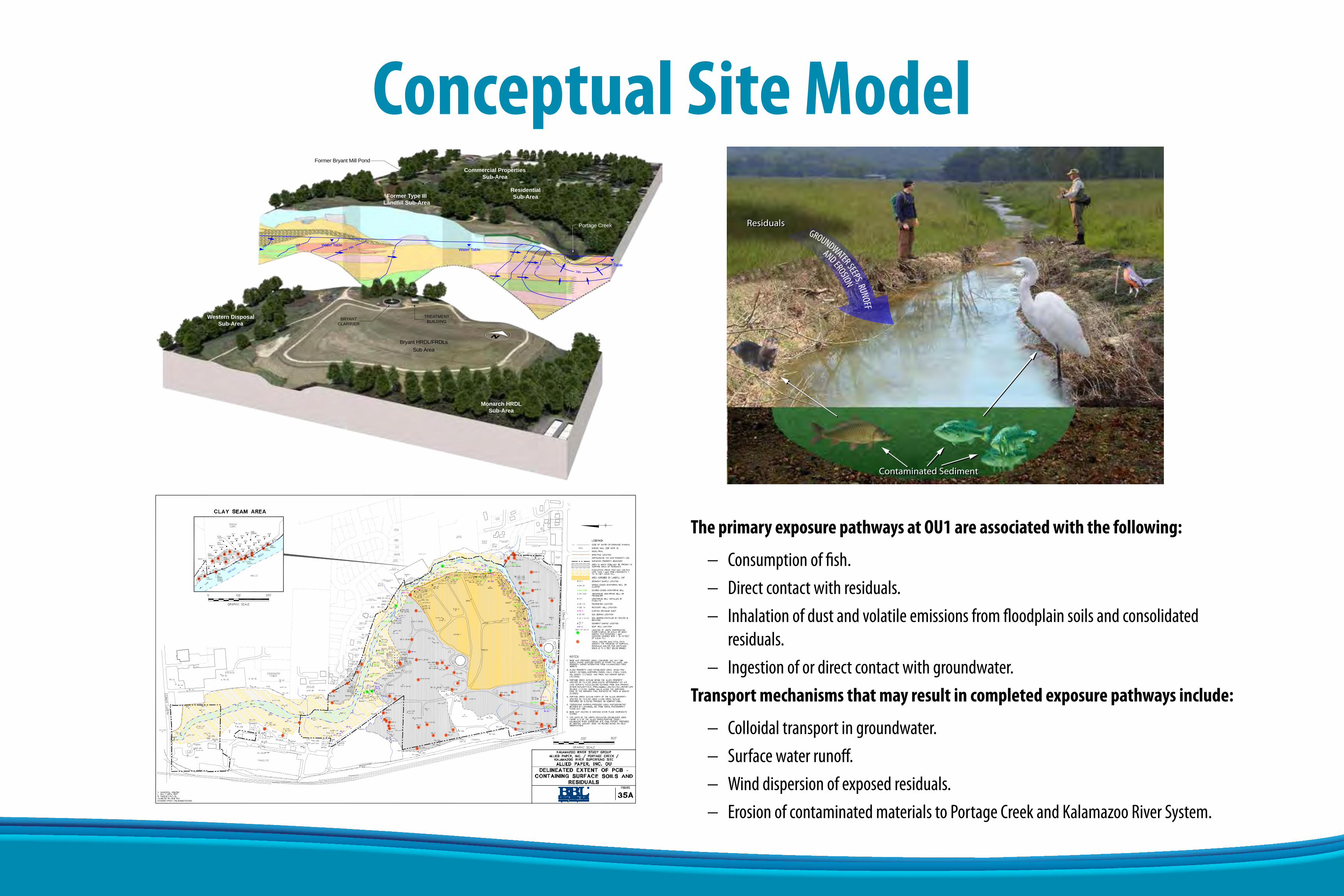
Conceptual Site Model
ES122013120057GNV Allied_OU-1_GW_CSM_rev3.ai 2/12/2014 DCD
Conceptual Site ModelAllied Paper OU-1Kalamazoo River Superfund SiteKalamazoo, Michigan
Water Table
Water Table
Water Table
784
796
795
797798799
79279
4
790
788
786
BRYANTCLARIFIER
TREATMENTBUILDING
Portage Creek
Bryant HRDL/FRDLsSub Area
Former Bryant Mill Pond
Former Type IIILandfill Sub-Area
Monarch HRDLSub-Area
Western DisposalSub-Area
ResidentialSub-Area
Commercial PropertiesSub-Area
ResidualsResiduals
Contaminated SedimentContaminated Sediment
AND EROSION
GROUNDWATER SEEPS, RUNOFF
The primary exposure pathways at OU1 are associated with the following:
− Consumptionoffish.− Directcontactwithresiduals.− Inhalationofdustandvolatileemissionsfromfloodplainsoilsandconsolidatedresiduals.
− Ingestionofordirectcontactwithgroundwater.Transport mechanisms that may result in completed exposure pathways include:
− Colloidaltransportingroundwater.− Surfacewaterrunoff.− Winddispersionofexposedresiduals.− ErosionofcontaminatedmaterialstoPortageCreekandKalamazooRiverSystem.

PCB Detections in Groundwater at Allied Landfill
CIT
Y: S
YR
AC
US
E, N
Y
GR
OU
P:
EN
VC
AD
-141
D
B: R
.ALL
EN
, P. L
ISTE
R, R
.ALL
EN
P
M: T
. GR
AN
ZEIE
R
TM
: L. C
OFF
EY
TR
: J. R
OB
ER
TSO
N
LYR
:ON
=*;O
FF=R
EF,
(FR
Z)G
:\EN
VC
AD
\SY
RA
CU
SE
\AC
T\B
0064
587\
0001
\000
04\D
WG
\645
87P
05.D
WG
LAYO
UT:
1-4
SAVE
D:
9/2/
2009
2:5
1 P
MA
CA
DV
ER:
17.0
S (L
MS
TE
CH
)P
AG
ES
ETU
P:
----
PLO
TSTY
LETA
BLE
:P
LTFU
LL.C
TBP
LOTT
ED
:9/
3/20
09 1
:45
PM
BY:
JON
ES, W
END
Y
MILLENNIUM HOLDINGS, LLCALLIED PAPER, INC. / PORTAGE CREEK /
KALAMAZOO RIVER SUPERFUND SITEALLIED PAPER, INC. OU
1-41-4
IMA
GE
S:
XR
EFS
:64
587X
1164
587X
DL
PR
OJE
CTN
AM
E:
----
PCB DETECTIONS IN GROUNDWATER2002 - 2003
•357groundwatersamplescollectedfrom1993through2003.
•2002and2003samplingeventbestrepresentscurrentconditionsafterTCRAwas performed.
− 57groundwaterlocationsweresampledforPCBsin2002/2003.
− 10ofthe57locationshadPCBdetections.
− 3ofthe10locationshadPCBconcentrationsaboveGSIcriteria.The3 exceedancesofGSIgroundwatercriteriaoccurredinwellsscreenedwithinorimmediatelyadjacenttotheresiduals.
•NocurrentevidenceofPCBsingroundwaterand/orimpactstoPortageCreekandfishinPortageCreek.

PCB Distribution in Subsurface
ES122013120057GNV Allied_OU-1_Wells_CSM_rev3.ai 1/30/2014 DCD
Soil Borings with PCB Concentrations Greater than 50 ppmAllied Paper OU-1Kalamazoo River Superfund SiteKalamazoo, Michigan
MW-8A WA-8
WA-6
MLSS-3MLSS-2
MLSS-1
MW-126B
MW-120B
MW-121B
MW-125B
BHDL-123
BHDL-22
WA-2
FLF-2FLF-1
DLHB-6MW-12R
0.3
9
31,100
5
1,100
195
260
174
480
51
0.4
800
120
300
0.04
0.2
0.08
60020.20.10.04
0.06
11
857 8
14029120.2
0.06
6509651270.04
0.4
630
69
2,5003301300.2
17
6
1202813100.5
1100.5
18896110
0.07
0.2
959723
20.08
0.05
2.42,000
8526024075
0.30.6
1201910
3
4309317
0.05
100
0.07
0.060.06
0.2
370
2203302200.08
BRYANTCLARIFIER
TREATMENTBUILDING
Portage Creek
Bryant HRDL/FRDLsSub-Area
Former Bryant Mill Pond
Former Type IIILandfill Sub-Area
Monarch HRDLSub-Area
Western DisposalSub-Area
ResidentialSub-Area
Commercial PropertiesSub-Area
Borings Locations withPCB Contaminations Greater than 50 ppm
Legend
Colors = Total PCB Concentrations (ppm)
White = No Data
Soil Boring,Typical Depth
GroundSurface
Subsurface
WA-8 Boring IDBoring Location
<1 ppm1 - 10 ppm10 - 50 ppm50 - 500 ppm>500 ppm

Nature of PCBs in the Environment
PCBs do not dissolve readily and typically stay bonded to particulates.
− PCBsbindstronglytoorganicmaterial.
− Residualsaregreyclayandfibrouswoodmaterial,highinorganicscontent.
− 65ofthe66soilorsedimentsampleswithPCBconcentrations>10mg/kgcontained residuals.
PCB mobility also affected by soil density, particle size distribution, moisture content, and soil permeability.
− PCBsattachedtosmallmobileparticulates(colloids)maytravelingroundwater.
− ResidualsatAlliedLandfillsimilartoclaysandallowlittlewaterflowthroughthem.
Bound toOrganic Material
(immobile)
Dissolved inGroundwater
(mobile)
Bound toColloids
(mobile in GW)PCBs Colloid
Soil Particle

Remedial Action Objectives (RAO)
RAOsaregoalsforprotectinghumanhealthandthe environment.
RAO 1 – MitigatethepotentialforhumanandecologicalexposuretomaterialsatOU1containingCOCconcentrationsthatexceedapplicablerisk-basedcleanupcriteria.
RAO 2 – MitigatethepotentialforCOC-containingmaterialstomigrate,byerosionorsurfacewaterrunoff,intoPortageCreekorontoadjacentproperties.
RAO 3 – PreventcontaminatedwastematerialattheOU1 landfillfromimpactinggroundwaterandsurface water.
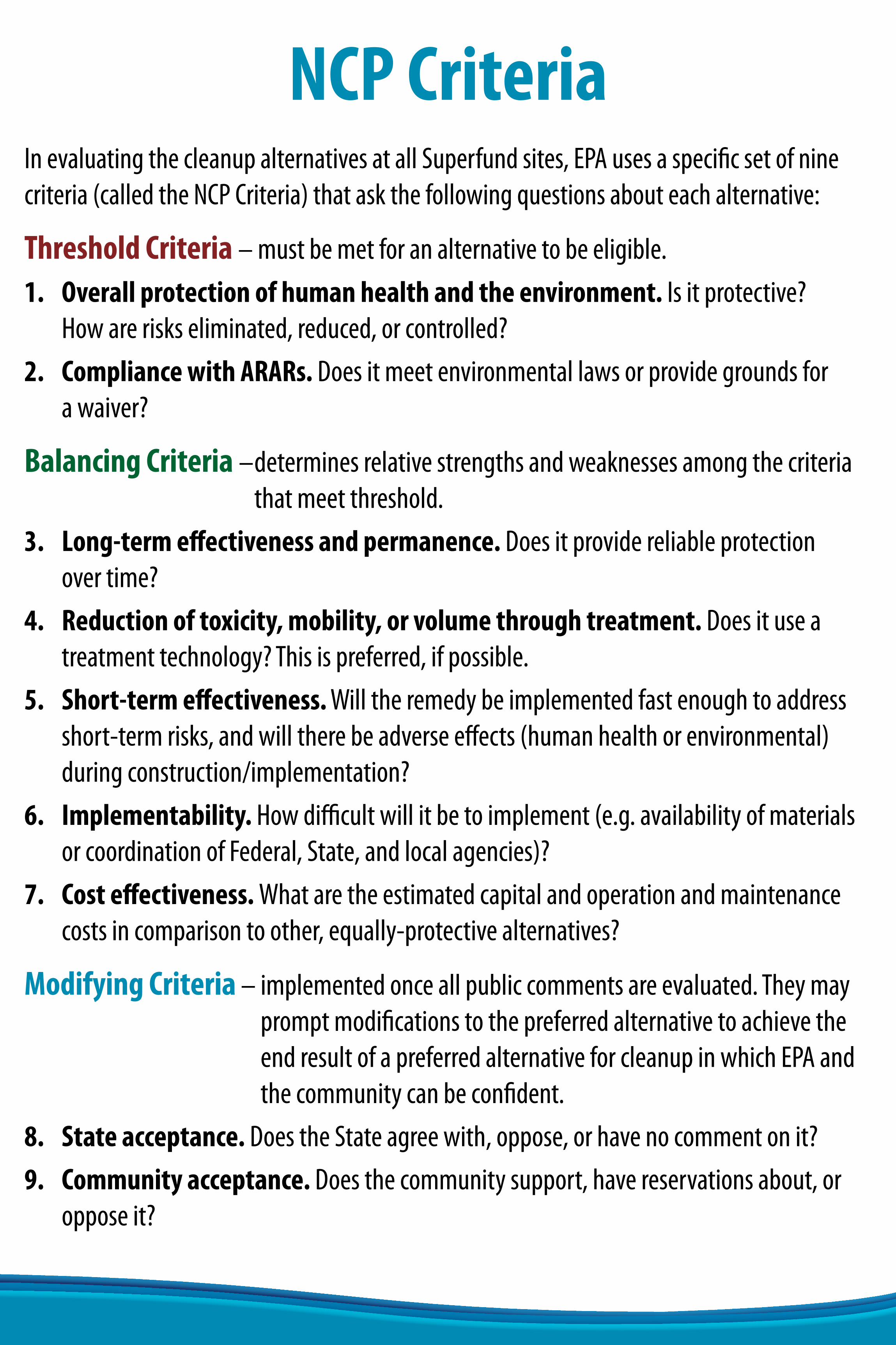
NCP CriteriaInevaluatingthecleanupalternativesatallSuperfundsites,EPAusesaspecificsetofninecriteria(calledtheNCPCriteria)thataskthefollowingquestionsabouteachalternative:
Threshold Criteria –mustbemetforanalternativetobeeligible.1. Overall protection of human health and the environment.Isitprotective?
How areriskseliminated,reduced,orcontrolled?2. Compliance with ARARs. Doesitmeetenvironmentallawsorprovidegroundsfor
a waiver?
Balancing Criteria –determinesrelativestrengthsandweaknessesamongthecriteriathatmeetthreshold.
3. Long-term effectiveness and permanence.Doesitprovidereliableprotectionover time?
4. Reduction of toxicity, mobility, or volume through treatment. Doesituseatreatmenttechnology?Thisispreferred,ifpossible.
5. Short-term effectiveness.Willtheremedybeimplementedfastenoughtoaddressshort-termrisks,andwilltherebeadverseeffects(humanhealthorenvironmental)duringconstruction/implementation?
6. Implementability. Howdifficultwillitbetoimplement(e.g.availabilityofmaterialsorcoordinationofFederal,State,andlocalagencies)?
7. Cost effectiveness. Whataretheestimatedcapitalandoperationandmaintenancecostsincomparisontoother,equally-protectivealternatives?
Modifying Criteria–implementedonceallpubliccommentsareevaluated.TheymaypromptmodificationstothepreferredalternativetoachievetheendresultofapreferredalternativeforcleanupinwhichEPAandthecommunitycanbeconfident.
8. State acceptance. DoestheStateagreewith,oppose,orhavenocommentonit?9. Community acceptance.Doesthecommunitysupport,havereservationsabout,or
opposeit?

The Superfund Process
• Operation and maintenance with any alternative where wastes remain onsite.
• Performed every 5 years with any alternative where wastes remain onsite.
• EPA releases Proposed Plan identifying the preferred alternative for the site.
• EPA issues a Public Notice.
• Public Comment period on the Proposed Plan.
RI/FS
ProposedPlan
Record ofDecision
RemedialDesign
Ranking
RemedialAction
O&M
5-YearReview
• Remedial Investigation determines the nature and extent of contamination at the site.
• Feasibility Study identifies technologies capable of treating the contamination, and evaluates the cost and performance of alternatives that could be used to clean up the site.
• Explains which cleanup alternative was selected for the site.
• Contains Responsiveness Summary to public comments on the Proposed Plan.
• Engineering evaluations performed to design a safe and protective remedy.
• Plans and specifications are developed for construction.
• Prioritization Panel reviews and compares all of the Superfund projects that are construction ready (i.e., have designs completed) and require Federal funding.
• Process is used to distribute Superfund funding to start or continue construction at selected sites.
• Construction of the alternative selected in the ROD.
• Length of the remedial action can be affected by the amount of funding available each year.

Alternative 1 – No Further Action
BRYANT MILLPROPERTY
FORMERFILTER PLANT
LYONDELL
CORK STREET
•EvaluationofthisalternativeisrequiredundertheNationalContingencyPlan.
− Notprotectiveofhumanhealthandenvironment.DoesnotachieveRAOs.
− DoesnotcomplywithARARs.
•Noremovalorconsolidationofwastes.
•Nomaintenanceofexistingcap.
•Cost:$120,000.
Edge of Water or Drainage ChannelRoad/TrailApproximate Property Line f rom County Tax MapSurv ey ed Property BoundaryPrev iously Remediated Area
ALC
OTT
STR
EET
CLAY SEAM
PAVED LOT
PAVED LOT
PAVED LOT
BRYANTHRDL/FRDLs
(capped area)
FORMER TYPE III LANDFILL*
(consolidate perimeter materials under cap)
RESIDENTIALPROPERTIES
GOODWILLPROPERTY
ALCOTT STREET DAM
FORMERBRYANT MILL
POND
SHEETPILE WALL
BUILDING
LYONDELLPROPERTY
PANELYTEMARSH
WESTERNDISPOSAL AREA*(consolidate perimeter materials under cap)
PANELYTEPROPERTY CORK STREET
EAST BANK
MONARCHHRDL*
FORMERRACEWAYCHANNEL
CONSUMERSPOWER
PROPERTY
Select Removal and Onsite Consolidation
Install/Maintain Impermeable Engineered Barrier
Building/Paved Area
LEGEND
* Limits of consolidation, cover, and removal areas to be determined during remedy design phase.
– Use Institutional Controls
CO
RK
STR
EET
PORTAGE CREEK
BRYANT MILLPROPERTY
FORMERFILTER PLANT
CORK STREET
LYONDELL
BRYANT MILLPROPERTY
FORMERFILTER PLANT
Select Removal and Onsite Consolidation
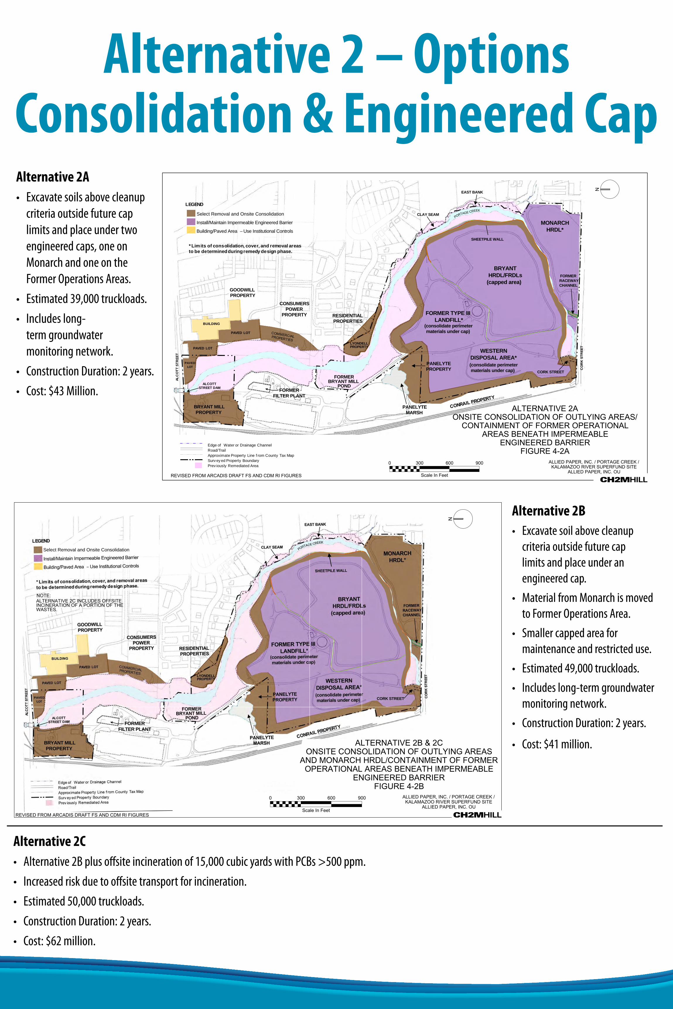
Alternative 2 – Options Consolidation & Engineered CapAlternative 2A• Excavatesoilsabovecleanup
criteriaoutsidefuturecaplimitsandplaceundertwoengineeredcaps,oneonMonarchandoneontheFormerOperations Areas.
• Estimated39,000truckloads.• Includeslong-
termgroundwatermonitoring network.
• ConstructionDuration:2 years.• Cost:$43Million.
Alternative 2B• Excavatesoilabovecleanup
criteriaoutsidefuturecaplimitsandplaceunderanengineered cap.
• MaterialfromMonarchismovedtoFormerOperationsArea.
• Smallercappedareaformaintenanceandrestricteduse.
• Estimated49,000truckloads.• Includeslong-termgroundwater
monitoringnetwork.• ConstructionDuration:2 years.
• Cost:$41million.
Alternative 2C• Alternative2Bplusoffsiteincinerationof15,000cubicyardswithPCBs>500 ppm.• Increasedriskduetooffsitetransportforincineration.• Estimated50,000truckloads.• ConstructionDuration:2years.• Cost:$62million.
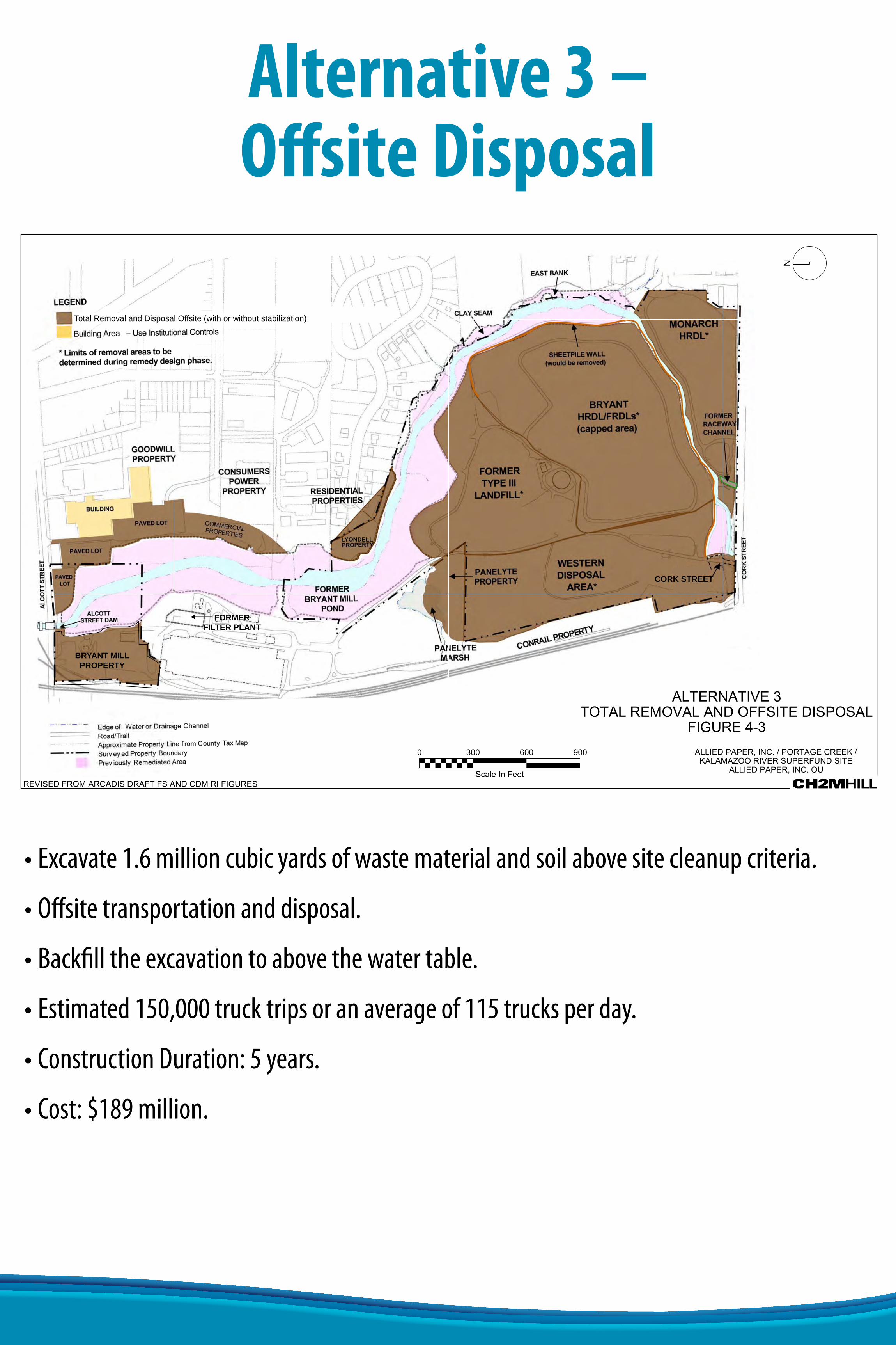
Alternative 3 – Offsite Disposal
•Excavate1.6millioncubicyardsofwastematerialandsoilabovesitecleanupcriteria.
•Offsitetransportationanddisposal.
•Backfilltheexcavationtoabovethewatertable.
•Estimated150,000trucktripsoranaverageof115trucksperday.
•ConstructionDuration:5years.
•Cost:$189million.
BRYANT MILLPROPERTY
FORMERFILTER PLANT
LYONDELL
CORK STREET
Total Removal and Disposal Offsite (with or without stabilization)

Alternative 4 – Construction of Fully Encapsulating Landfill
•Excavate1.6millioncubicyardsofsoilabovecleanupcriteria.
•Import800,000cubicyardsofcleansoiltoraisebottomelevationabovewatertableandconstructbottomliner.
•1.1millioncubicyardsplacedinlandfillconstructedonsiteand500,000cubicyardsofmaterialsoffsitefordisposalduetolimitedcapacity.
•Estimated116,000trucktripsoranaverageof90trucksperday.
•Includeslong-termgroundwatermonitoringnetwork.
•ConstructionDuration:10years.
•Cost:$136million.
FORMERFILTER PLANT
LYONDELL
Select Removal with Onsite Consolidation and Offsite Disposal (as required due to volume)
CORK STREET
BRYANT MILLPROPERTY

Landfill Cap Construction Details

Key Feasibility Study Assumptions
•Clean up criteria will be dependant on land use and vary throughout the site.
− ResidentialSoilCriteria:1mg/kg− Non-ResidentialSoilCriteria:10mg/kg− SedimentCriteria:0.33mg/kg− Visuallyidentifiedresidualswillberemovedandfollowedbyanalyticaltestingtodetermineextents.
− ActualcriteriawillbeestablishedintheRecordofDecision.
•Design investigation is required to refine quantities and extents of contamination.
•Sources for imported soils are assumed to be within 40 miles of the site.
•Disposal facilities are assumed as follows:− <40milesforsoils<50mg/kg(Alternatives3and4)− 150milesforsoils>50mg/kg(Alternative3)− 1,200milesforsoils>500mg/kg(Alternative2C)
•Construction is assumed to be limited to Monday through Friday, from 7:00 am to 6:00 pm.
•Construction is generally expected to be performed between the months of April and November.