jupiter project san bernardino county, california …
TRANSCRIPT

JUPITER PROJECTSAN BERNARDINO COUNTY, CALIFORNIA
UPDATEDBIOLOGICAL RESOURCES
REPORT
Submitted to:Haskell Architects & Engineers P.A., Inc.
111 Riverside AvenueJacksonville, Florida 32202
Contact:Michael H. Wheeler P.E., Director, Group Lead Civil Engineer
(904) [email protected]
Submitted by:AMEC Foster Wheeler
Environment & Infrastructure Americas3120 Chicago Avenue, Suite 110
Riverside, California 92507
Contact:Tom Egan,
Senior Ecologist(951) 634-9769
January 2016
AMEC Foster Wheeler Project No. 1555400632

Haskell A & EJupiter ProjectUpdated Biological Resources Report
AMEC Foster Wheeler Project No. 1555400632 ES-1
EXECUTIVE SUMMARY
AVDC Inc. has proposed surface development of a 106.4-acre private property at 18880 NavajoRoad, in north Apple Valley, San Bernardino County, California to construct a distribution center,as wells as the improvement of 44 feet-width right-of-ways associated with Lafayette Road,Navajo Road and Daschund Road (which border this parcel, collectively, the “Project” or the“Jupiter Project”. Amec Foster Wheeler, on behalf of Haskell Architects & Engineers P.A., Inc.,completed a background review and general biological resources survey on these lands on 14-16 April, 2015. A focused Agassiz’s desert tortoise (Gopherus agassizii) survey was alsoconducted. A state and federal waters delineation/analysis was subsequently conducted on 9 May2015; as was a desert kit fox (Vulpes macrotis) study/burrow excavation effort on 2-8 December2015. Individual reports documenting these efforts have previously been prepared. This updatedbiological resources report incorporates and summarizes information from all biological fieldworkconducted on the subject property.
The primary purpose of the biological resources survey was to document and assess onsite plantcommunities and their condition and wildlife habitat present. A specific emphasis was todetermine if any state/federally listed plants/animals, California Species of Special Concern orspecial status plants occur on the property. The focused Agassiz’s desert tortoise survey wasconducted to determine if this state/federally listed species occurred on the property or in theimmediate zone of influence. The state and federal waters survey/analysis was conducted toascertain if specific permitting was necessary relative to construction work on these lands. Thedesert kit fox study/burrow excavation effort was conducted to determine this species’ activitylevels on the property and to collapse unoccupied burrows prior to construction work taking place.
Affected lands are located east of Interstate Highway 15, northeast of Bell Mountain andnorthwest of the Apple Valley County Airport. Unpaved Burbank Avenue provides vehicle accessto the southern portion of the property from either the paved Dale Evans Parkway on the west orNavajo Road on the east. Survey transects of 66 feet-width were conducted throughout theinterior of the subject property during the biological survey; along with seven 66 feet-width buffersampling transects consistent with burrowing owl (Athene cunicularia) survey guidelines. Tortoisepresence-absence belt transects of 30 feet-width across the parcel and zone of influencesampling transects (USFWS 2010a) at 656 ft, 1,312 ft and 1,969 feet intervals around this propertywere also conducted. Plant communities were assessed as to condition and capability to supportnative wildlife. A branched, narrow width, shallow depth wash bisects the property and wascarefully reviewed in the subsequent state/federal waters survey and analysis.
Aerial military maneuvers involving “sand bombs” and a paved target zone once occurred alongthe western edge of this parcel. A disturbed, moderate diversity creosote bush (Larrea tridentata)-white bursage (Ambrosia dumosa) alliance with widely-spaced creosote bushes, barren groundand annual grasses characterizes the affected plant community. Past domestic sheep (Ovis aries)grazing on the property is evidenced by a reduced number of native subshrubs. No cholla(Cylindropuntia spp.), thorny shrubs or Joshua tree (Yucca brevifolia) occur on the parcel.

Haskell A & EJupiter ProjectUpdated Biological Resources Report
AMEC Foster Wheeler Project No. 1555400632 ES-2
Wildlife common to a Mojave Creosote Bush Scrub plant community were noted on the property.No state/federally listed species, including the state/federally listed threatened desert tortoise,were found to occur on the property or in the adjacent zone of influence. One loggerhead shrike(Lanius ludovicianus), a California Species of Special Concern, was observed on the property.No other special status plant or animal species were observed. No Yucca species, cacti or othernative plant specifically addressed by the California Native Plant Act or Town of Apple ValleyGeneral Plan were found to occur.
Eight presumed-inactive desert kit fox burrows were recorded on the property during the biologicalresources survey effort. Desert kit fox is not currently state/federally listed, nor has it beendesignated a special status species in the state. However, per Title 14 California Code ofRegulations §460 relative to California furbearers, desert kit fox cannot be “taken” (i.e., injured,killed) at any time. The desert kit fox study/burrow excavation effort undertaken in December 2015documented nocturnal activity by the species on the property and confirmed that the eightpreviously identified burrows were inactive. These burrows were subsequently excavated andcollapsed to prevent wildlife entry/occupation.
Several recently-fledged nests of the migratory bird cactus wren (Campylorhynchusbrunneicapillus) were recorded on land adjacent to the property, i.e., in the property’s buffer zone,but not on the property. This species is not state/federally listed or designated a species of specialconcern in San Bernardino County: however, nests of the species/nesting activity are protectedunder provisions of the Migratory Bird Act and California Fish and Game Code. While the subjectproperty provides foraging habitat for cactus wren, which is quite common in the region, no nestsor suitable nesting habitat (i.e., cholla, thorny shrubs or Joshua tree) was found to occur on theproperty.
A branched and shallow, southwesterly-tending, ephemeral wash bisects the Jupiter Project siteproperty but does not to flow into a Traditionally Navigable Waterway; nor is any riparian orwetland vegetation present. The U.S. Army Corps of Engineers has determined that the washsystem is not within its jurisdiction as waters of the U.S. (“WUS”) pursuant to the Clean Water Act.The wash system is within the jurisdiction of the Lahontan Regional Water Quality Control Board(Region 6) (the “Regional Board”) as it is a water of the State of California (“WSC”). The RegionalBoard has determined the Project requires a Waste Discharge Requirements and an applicationfor this authorization has been submitted. The California Department of Fish and Wildlife hasdetermined a 1602 Streambed Alteration Agreement is necessary, and Streambed AlterationAgreement Notification Number 1600-2015-0086-R6 has been issued, which containsadministrative, as well as impact avoidance and minimization, measures.
Property development recommendations are presented. These include worker environmentalawareness training, pre-construction biological survey/burrow excavation and development of atrash abatement plan.

Haskell A & EJupiter ProjectUpdated Biological Resources Report
AMEC Foster Wheeler Project No. 1555400632 Page i
TABLE OF CONTENTS
EXECUTIVE SUMMARY ......................................................................................................ES-1ACRONYMS AND ABBREVIATIONS...........................................................................................iii1.0 INTRODUCTION......................................................................................................... 1-1
1.1 Project Description............................................................................................1-11.2 Project Location ................................................................................................1-1
2.0 FOCUSED STUDY/SPECIES OF CONCERN............................................................. 2-12.1 General Biological Resources...........................................................................2-1
2.1.1 Special Status Species..........................................................................2-12.1.2 Migratory Birds ......................................................................................2-12.1.3 Invasive, Non-native Species ................................................................2-2
2.2 Literature Review..............................................................................................2-22.2.1 Agassiz’s Desert Tortoise (Gopherus agassizii).....................................2-22.2.2 Burrowing Owl (Athene cunicularia).......................................................2-32.2.3 Cactus wren (Campylorhynchus brunneicapillus) ..................................2-42.2.4 Desert Kit Fox (Vulpes macrotis) ...........................................................2-52.2.5 Golden Eagle (Aquila chrysaetos) .........................................................2-62.2.6 Le Conte’s Thrasher (Toxostoma lecontei) ............................................2-62.2.7 Loggerhead Shrike (Lanius ludovicianus) ..............................................2-72.2.8 Prairie Falcon (Falco mexicanus) ..........................................................2-72.2.9 Migratory Birds ......................................................................................2-72.2.10 Invasive, Non-native Species ................................................................2-8
3.0 SURVEY METHODOLOGY......................................................................................... 3-13.1 General Biological Resources Survey ...............................................................3-13.2 Focused Desert Tortoise Survey.......................................................................3-33.3 State/Federal Waters Delineation and Analysis ................................................3-3
4.0 DESERT KIT FOX ACTIVITY MONITORING AND BURROW EXCAVATIONMETHODOLOGY ........................................................................................................ 4-1
5.0 RESULTS.................................................................................................................... 5-15.1 Environmental Setting.......................................................................................5-1
5.1.1 Climate..................................................................................................5-15.1.2 Topography...........................................................................................5-15.1.3 Waters of the United States & California Streambeds ...........................5-1
5.2 Vegetation.........................................................................................................5-35.3 Wildlife ..............................................................................................................5-65.4 Special Status Species .....................................................................................5-6
5.4.1 Agassiz’s Desert Tortoise......................................................................5-65.4.2 Burrowing Owl.......................................................................................5-95.4.3 Golden Eagle..........................................................................................5-95.4.4 Le Conte's Thrasher................................................................................5-95.4.5 Loggerhead Shrike..................................................................................5-95.4.6 Prairie Falcon..........................................................................................5-9
5.5 Migratory Birds................................................................................................5-105.6 Invasive, Non-native Species..........................................................................5-105.7 Habitat Connectivity and Corridors..................................................................5-12

Haskell A & EJupiter ProjectUpdated Biological Resources Report
AMEC Foster Wheeler Project No. 1555400632 Page ii
6.0 CONCLUSIONS .......................................................................................................... 6-17.0 RECOMMENDATIONS ............................................................................................... 7-18.0 REFERENCES............................................................................................................ 8-19.0 CERTIFICATION......................................................................................................... 9-1
LIST OF TABLES
Table 1. Desert Tortoise Sign Classification Key..............................................................3-5Table 2. Summary of Jurisdictional Drainages on the Jupiter Project Property................5-3
LIST OF FIGURES
Figure 1. Vicinity & Location..............................................................................................1-2Figure 2. Project Development Map..................................................................................1-3Figure 3a. Survey Area & Buffer Sampling Transects.........................................................3-2Figure 3b. Desert Tortoise Survey Transects Map..............................................................3-4Figure 4. Jurisdictional Delineation Map............................................................................5-2Figure 5a. Plant Community Photographs: Property...........................................................5-4Figure 5b. Plant Community Photograph: Ephemeral Wash...............................................5-5Figure 6. Biological Resources Survey Results Overview Map.........................................5-7Figure 7. Photographs of Desert Kit Fox Burrow Underground Scoping, Excavation
& Collapse work..................................................................................................5-8Figure 8. Loggerhead Shrike Observed on the Project Jupiter Property.........................5-10
LIST OF APPENDICES
APPENDIX A CALIFORNIA NATURAL DIVERSITY DATABASE REPORTAPPENDIX B BIOLOGICAL SURVEYOR QUALIFICATIONS STATEMENTSAPPENDIX C VASCULAR PLANT SPECIES RECORDED IN PROJECT AREAAPPENDIX D ANIMAL SPECIES RECORDED IN PROJECT AREAAPPENDIX E STREAMBED ALTERATION AGREEMENT NOTIFICATION NO. 1600-2015-
0086-R6 (CITY OF APPLE VALLEY PROJECT JUPITER)

Haskell A & EJupiter ProjectUpdated Biological Resources Report
AMEC Foster Wheeler Project No. 1555400632 Page iii
ACRONYMS AND ABBREVIATIONS
ac acre, acres
amsl above mean sea level
APN San Bernardino County Assessor’s Parcel Number
CCR California Code of Regulations
CDFG California Department of Fish and Game
CDFW California Department of Fish and Wildlife; formerly CDFG
CEQA California Environmental Quality Act
CESA California Endangered Species Act
CFGC California Fish and Game Code
CHU critical habitat unit
CNDDB California Natural Diversity Database
CWA Clean Water Act
EO Executive Order
ESA Endangered Species Act
ºF degrees Fahrenheit
FAC Facultative
FACU facultative upland
FACW facultative wetland
ft foot/feet
ft² square foot/feet
GIS geographic information systems
GPS global positioning system
Haskell A & E Haskell Architects & Engineers P.A., Inc.
in inch, inches
I-15 Interstate Highway 15
m Meter
mi Mile
mi² square mile
min Minute
NWI National Wetlands Inventory
NL not listed
OBL Obligate

Haskell A & EJupiter ProjectUpdated Biological Resources Report
AMEC Foster Wheeler Project No. 1555400632 Page iv
OHWM Ordinary High Water Mark
Project Jupiter
RWQCB Regional Water Quality Control Board
SAA Streambed Alteration Agreement
TNW Traditionally Navigable Waterway
UPL Upland
USDA United States Department of Agriculture
USACE United States Army Corps of Engineers
USGS United States Geological Survey
USFWS United States Fish and Wildlife Service
WEAP Worker Environmental Awareness Program
WSC Waters of the State of California
WUS Waters of the United States
Haskell A & EJupiter ProjectUpdated Biological Resources Report
AMEC Foster Wheeler Project No. 1555400632 Page 1-1
1.0 INTRODUCTION
AVDC Inc. has proposed the Jupiter Project, which entails surface development of a private parcelin north Apple Valley, San Bernardino County, California (Figure 1) in order to construct adistribution center, as well as improvement of adjacent rights-of-way. Amec Foster Wheeler(formerly AMEC Environment & Infrastructure, Inc.) was contracted by Haskell Architects &Engineers P.A., Inc. (Haskell A & E) to conduct a general biological resources survey, focusedAgassiz’s desert tortoise (Gopherus agassizii) survey, a state/federal waters delineation and adesert kit fox (Vulpes macrotis) study/burrow excavation effort for the proposed Jupiter Projectsite.
The primary purpose of the biological resources survey effort was to identify onsite plantcommunities and their condition and wildlife present within, or known to travel through, theimmediate area and adjacent lands. A specific emphasis of this survey was to determine if anystate/federally listed plants/animals, California Species of Special Concern, special status plantsor species addressed by the California Native Plant Act and/or Apple Valley General Plan, occuron the property. The focused Agassiz’s desert tortoise survey was conducted to determine if thisstate/federally listed species occurred on the property or in the immediate zone of influence. Thestate and federal waters survey/analysis was conducted to ascertain if specific permitting wasnecessary relative to proposed construction work. The desert kit fox study/burrow excavationeffort was conducted to determine this species’ activity levels on the property and to collapseunoccupied burrows prior to proposed construction work taking place.
1.1 Project Description
A total of 106.4 acres (ac) of development has been proposed for the Jupiter Project (Figure 2),as well as improvement of 44 feet (ft)-width right-of-ways associated with Lafayette Road, NavajoRoad and Daschund Road bordering the Jupiter Project site property.
1.2 Project Location
The Jupiter Project site is located at 18880 Navajo Road, in northern Apple Valley, SanBernardino County, California (refer to Figures 1-2). The property is situated approximately 3.5miles (mi) east of the Stoddard Wells Road exit of Interstate Highway 15 (I-15). The legaldescription is Township 6 North, Range 3 West, northeast-southeast Section 21 fractional, SanBernardino Base and Meridian (Apple Valley North SE 7.5 minute (min.) quadrangle; U.S.Geological Survey (USGS) 1970, rev. 1993).
Bell Mountain is located roughly one mi to the southwest of this property and the Apple ValleyCounty Airport is located approximately 0.25 mi to the southeast. The unpaved Burbank Avenueprovides vehicle access to these lands from Dale Evans Parkway in the west and from NavajoRoad in the east. A fenced Walmart Distribution Center and other buildings are locatedimmediately to the north; with the Black Mountain Quarry Railroad located slightly further to thenorth; and vacant lands are situated to the south. Historic aerial military maneuvers involving“sand bombs” and a paved target zone occur along the western edge of this parcel.

FIGURE
µDate: 5/5/2015
0 1 20.5Miles
1 inch = 2 miles
Preparded By: Mindy Beohm, AMEC FWSource: 33702201CM-01.dwg Group Layer
§̈¦15£¤395
¬«18
Vicinity & LocationHaskell A&E Jupiter Project 1
RVShare\active projects\Project Jupiter Surveys 1555400632\maps\report

SET MAG (BASE/AT-1)
1013061.75
SET MAG (AT-3)
1033030.85SET S&W (AT-4)
1043007.48
SET S&W (AT-6)
1063030.25 LAFAYETTE R OAD
NAVA
JO RO
AD
DACH
SHUN
D AVE
NUE
P.M.B. 209/10-11
TRACT 5966MB 76/100-104
LIVERMORE ST.
21
28
22
27
BURBA NK ST.
P.M.B. 127/99-100M.B. 103/67-75
P.M.B. 231/16-17
P.M.B. 68/1
BURBA NK AVEN UE
P.M.B. 25/4
DACH
SHUN
D AVE
NUE
SE 1/4 SEC. 21T.6N., R.3W., S.B.M.
LOS PAR DES (LIVERMORE ST.)
AT -1030 30 .02
MH
F/ HV
MH
ASPH
ASPH
ASPH
ASPH
ASPH
ASPH
SCAT TERE DBRU SH
SCAT TERE DBRU SH
SCAT TERE DBRU SH
SCAT TERE DBRU SH
SCAT TERE DBRU SH
SCAT TERE DBRU SH
SCAT TERE DBRU SH
SCAT TERE DBRU SH
SCAT TERE DBRU SH
SCAT TERE DBRU SH
SCAT TERE DBRU SH
SCAT TERE DBRU SH
SCAT TERE DBRU SH
AT -630 30 .25
AT -730 33 .15
ASPH ASPH
ASPH
DIR T DIR TDIR T
SCAT TERE DBRU SH
SCAT TERE DBRU SH
SCAT TERE DBRU SH
SCAT TERE DBRU SH
SCAT TERE DBRU SH
SCAT TERE DBRU SH
SCAT TERE DBRU SH
SCAT TERE DBRU SHSCAT TERE D
BRU SH
SCAT TERE DBRU SH SCAT TERE D
BRU SH SCAT TERE DBRU SH
SCAT TERE DBRU SH SCAT TERE D
BRU SH SCAT TERE DBRU SH
SCAT TERE DBRU SH
SCAT TERE DBRU SH
SCAT TERE DBRU SH
SCAT TERE DBRU SH
SCAT TERE DBRU SH
SCAT TERE DBRU SH
SCAT TERE DBRU SH
SCAT TERE DBRU SHSCAT TERE D
BRU SH
S
SCAT TERE DBRU SH
SCAT TERE DBRU SH SCAT TERE D
BRU SH
SCAT TERE DBRU SH
SCAT TERE DBRU SHSCAT TERE D
BRU SH
SCAT TERE DBRU SH
SCAT TERE DBRU SH
SCAT TERE DBRU SH
SCAT TERE DBRU SH
SCAT TERE DBRU SH
SCAT TERE DBRU SH
U/ O
AT -130 61 .74
AT -830 47 .76
U/ O
F/ H
F/ H
U/ OU/ OU/ O
U/ O
MH
MH
MH
S
V
ASPH
ASPH
ASPHASPH
ASPH
ASPH
ASPH
ASPH ASPH
ASPHASPH
DIR T
DIR T
DIR T
SCAT TERE DBRU SH
SCAT TERE DBRU SH
SCAT TERE DBRU SH
SCAT TERE DBRU SH
BRU SHSCAT TERE D
SCAT TERE DBRU SH
SCAT TERE DBRU SH
SCAT TERE DBRU SH
SCAT TERE DBRU SH
SCAT TERE DBRU SH
SCAT TERE DBRU SH
SCAT TERE DBRU SH
SCAT TERE DBRU SH
SCAT TERE DBRU SH
SCAT TERE DBRU SH
SCAT TERE DBRU SH
SCAT TERE DBRU SHSCAT TERE D
BRU SH
SCAT TERE DBRU SH
SCAT TERE DBRU SH
SCAT TERE DBRU SH
SCAT TERE DBRU SH
SCAT TERE DBRU SH
SCAT TERE DBRU SHSCAT TERE D
BRU SH
SCAT TERE DBRU SH
SCAT TERE DBRU SH
SCAT TERE DBRU SH
SCAT TERE DBRU SH
SCAT TERE DBRU SH
SCAT TERE DBRU SH
SCAT TERE DBRU SH
SCAT TERE DBRU SH
SCAT TERE DBRU SH
SCAT TERE DBRU SH
SCAT TERE DBRU SH
SCAT TERE DBRU SH
ASPH
DIR T
AT -530 18 .89
DIR T
DIR T
DIR T DIR T
DIR T
ASPH
RIP RAP
AT -430 07 .48
AT -330 30 .85
MH
MH
AT -930 20 .36
MH
DIR T
AT -230 45 .28
MH
MH
F/ H
V
ASPH
U/ OU/ O
U/ O
U/ O
(9 09) 889 - 2420San B er na r din o, C A 9 240 8
431 M ac K ay D r iveJob # AM C 14- 2 30
Fr om Ae ri al P ho to gr aph y Da te d : 12 -1 8- 14Co m pil ed b y A r ro w hea d M a ppi ng C or po r at ion
LAFAYETTE ST.
DACH
SHUN
D ST.
NAVA
JO RO
AD
BURBA NK ST.
LOS PAD RES ROAD
DEVELOPMENT PARCEL106.4 ACRES
FIGURE
µDate: 1/15/2016
0 250 500125Feet
1 inch = 500 feet
Preparded By: Mindy Beohm, AMEC FWSource: 33702201CM-01.dwg Group Layer
Project Development MapHaskell A&E Jupiter Project 2
RVShare\active projects\Project Jupiter Surveys 1555400632\maps\report
LegendProject Site
Haskell A & EJupiter ProjectUpdated Biological Resources Report
AMEC Foster Wheeler Project No. 1555400632 Page 2-1
2.0 FOCUSED STUDY/SPECIES OF CONCERN
2.1 General Biological Resources
Biological resources found on the subject property include both native and introduced plant andanimal species, with most highly adapted to the arid environment of the central Mojave Desert.These resources include general plant and animal species which typify the area and the habitatsthey occupy; habitat associated with a number of special status species; as well as a few invasive,non-native species. One special status bird (Loggerhead Shrike) was observed on the edge ofthe property, and desert kit fox (protected under Title 14 California Code of Regulations §460)were observed to pass through the property. This report updates a previous general biologicalresources report for the subject property (Amec Foster Wheeler 2015a).
2.1.1 Special Status Species
Plant and animal taxa may be considered “special-status” due to declining populations,vulnerability to habitat change or loss, or restricted distribution. Certain of these species havebeen listed as threatened or endangered by the U.S. Fish and Wildlife Service (USFWS) and/orCalifornia Department of Fish and Wildlife (CDFW), and are protected by the Endangered SpeciesAct (ESA) and California Endangered Species Act (CESA), respectively.
Some state-listed species and certain other plants are also protected or regulated underprovisions of the Native Plant Protection Act (California Fish and Game Code [CFGC] §§1900-1913) or Town of Apple Valley Ordinance (i.e., Joshua tree [Yucca brevifolia]). Other specieshave been identified as special-status by private conservation organizations such as the CaliforniaNative Plant Society (CNPS) in conjunction with the CDFW.
Special status species recorded from the Apple Valley North 7.5-minute mapping quadrangle(USGS 1970, rev. 1993) region are listed in Appendix A. Those special status species consideredto have a low to high potential for occurrence on the subject property or immediately adjacentlands are addressed in Section 2.2 below.
2.1.2 Migratory Birds
Migratory birds are known to travel, forage and nest in the area proposed for facility installation.Construction activities can result in the destruction of migratory bird nests or adversely affectnestling survival. Migratory birds are protected under the Migratory Bird Treaty Act (16 U. S. Code

Haskell A & EJupiter ProjectUpdated Biological Resources Report
AMEC Foster Wheeler Project No. 1555400632 Page 2-2
Sections 703-711) and CFGC §§3503, 3503.5 (protection of birds’ nests), CFGC §§3503 3511(fully protected birds), and CFGC §§3503 3513 (taking of Migratory Bird Treaty Act birds).
The Neotropical Migratory Bird Conservation Act of 2000 and Executive Order 13186[Responsibilities of Federal Agencies to Protect Migratory Birds] (Clinton 2001) also encouragehabitat protection for migratory birds.
2.1.3 Invasive, Non-native Species
Executive Order 13112 [Invasive Species] (Clinton 1999) instructs federal agencies to preventthe introduction of invasive, non-native species; as well as provide for their control.
2.2 Literature Review
A review of state and federally listed species (CDFW 2015a, 2015b) was conducted prior to theinitiation of this survey. The California Natural Diversity Database (CNDDB) was also analyzedfor special status species records involving the Apple Valley North 7.5 min. topographicquadrangle (USGS 1970, rev. 1993) using the RAREFIND Version 3.1.0 commercial program(CDFW 2015c). A “Quick Viewer” (CDFW 2015d) public utility program (Appendix A) for specialstatus species recorded from this quadrangle was also reviewed; and the U.S. Fish and WildlifeService Environmental Conservation Online System (USFWS 2015a-b) was also reviewed forfederally listed species and designated critical habitat listed as occurring in the property vicinity.AMEC Foster Wheeler project files were also reviewed, along with the following environmentaland planning data sources:
California Desert Conservation Area Plan (BLM 1980), as amended (BLM 1999) West Mojave Plan Amendment to the CDCA Plan (BLM 2005); and Special animals (883 taxa) (CDFG 2011).
2.2.1 Agassiz’s Desert Tortoise (Gopherus agassizii)Federal/State Listing: Threatened
The long-lived Agassiz’s desert tortoise is known to occupy a variety of terrain and relatively openplant communities at a general elevation range of 1,000 to 3,500 ft above mean sea level (amsl)within the western Mojave range of the species (Boarman 2002). The species is most commonlyencountered in Mojave creosote bush (Larrea tridentata) scrub. Tortoises are dependent uponunderground burrows which are excavated in friable soil. Caliche wash banks, boulder crevicesand shrub cover are also used to escape temperature extremes and predation.
Habitat loss, degradation and fragmentation have adversely affected tortoises throughout thewestern Mojave Desert (Boarman 2002, USFWS 2011). Surface disturbance, vehicle use androads/highways have resulted in tortoise mortality and habitat impacts (USFWS 2011). LaRue(1993) and Boarman et al. (1997) have documented depauperate tortoise populations, and littleobservable sign of the species, along highways. Tortoise populations may be affected as far as0.25 mi or more from a roadway (Boarman and Sazaki 2006). In addition, human collection of

Haskell A & EJupiter ProjectUpdated Biological Resources Report
AMEC Foster Wheeler Project No. 1555400632 Page 2-3
tortoises, as well as common raven (Corvus corax) and coyote (Canis latrans) predation ofhatchling/juvenile tortoises, is known to impact tortoises along some roads and in some urbanizingareas (Boarman 1993). An upper respiratory tract disease associated with Mycoplasma spp.(Jacobson et al. 1991), which may be associated with the release of captive tortoises into the wild(Johnson et al. 2005), has also significantly reduced tortoise populations in many areas.
The subject property is within the southern portion of the central Mojave Desert range of the deserttortoise. These lands are not within habitat designated as critical for the tortoise; with the closestcritical habitat (i.e., Ord-Rodman CHU) located 13+ mi to the northeast. A previous tortoise surveyon this property (AMEC 2006) did not detect tortoises.
Nearby public lands have previously been characterized as BLM Category III desert tortoisehabitat (BLM 1989, 1998); with a management goal to “limit tortoise habitat and populationdeclines to the extent possible by mitigating impacts” (BLM and CDFG 1992). The general vicinityof the property has previously been characterized (BLM 1979) as once supporting a low densitytortoise population (0-20 tortoises/square mile [mi²]). A low to moderate density population (20-50 tortoises/mi²) was once estimated for lands situated 2-3 mi to the northwest (BLM 1979).However, tortoise density in much of the central and western Mojave Desert has declinedsubstantially in more recent years (BLM 2005; USFWS 2011).
2.2.2 Burrowing Owl (Athene cunicularia) Federal/State Listing: NoneMigratory Bird
CDFW: California Species of Special Concern
This small bird of prey is a grassland specialist of open areas with short vegetation and bareground in desert, grassland and shrub-steppe plant communities (USFWS 2003). Grinnell andMiller (1944) describe California habitat as “open, dry, nearly or quite level, grassland, prairie;desert floor”. Increased predation upon burrowing owls and/or lowered owl hunting success islikely associated with the species’ absence from areas of dense vegetation (Campbell 1998a).
The one universal characteristic of burrowing owl habitat is burrow presence (Rosenberg et al.2007), but the species will use banks, ditches, irrigation pipes, rubble and structures for shelterand nesting (Haug 1993). Burrows used by the species are commonly created by ground squirrelsand fossorial mammals (Gervais et al. 2008), as well as by desert tortoises (T. Egan, personalobservation [pers. obs.]). While a versatile raptor, it is a dietary specialist; with arthropods aprimary prey. While insects dominate their diet (Gervais et al. 2008), vertebrates account for amajority of biomass in some regions (Green et al. 1993). Prey may also be taken in proportion toits availability (Barrows 1989).
Human alterations can cause habitat loss by decreasing prey and suitable burrow availability orby increasing mortality risk associated with vehicle collision impacts and non-native predators.Vehicle impact risk in highway medians and along road shoulder may be particularly high for thisground-dwelling, feeding and flushing bird species. In the Mojave Desert (Garrett and Dunn1981), the species is uncommon, local/patchy in occurrence, and is in slow decline (Campbell
Haskell A & EJupiter ProjectUpdated Biological Resources Report
AMEC Foster Wheeler Project No. 1555400632 Page 2-4
1998a). The species is known to occur in central and southern portions of Apple Valley, California(T. Egan, pers. obs.).
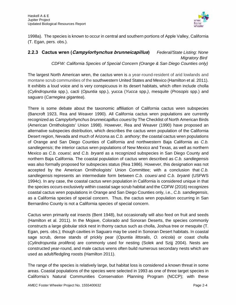
2.2.3 Cactus wren (Campylorhynchus brunneicapillus) Federal/State Listing: NoneMigratory Bird
CDFW: California Species of Special Concern (Orange & San Diego Counties only)
The largest North American wren, the cactus wren is a year-round-resident of arid lowlands andmontane scrub communities of the southwestern United States and Mexico (Hamilton et al. 2011).It exhibits a loud voice and is very conspicuous in its desert habitats, which often include cholla(Cylindropuntia spp.), cacti (Opuntia spp.), yucca (Yucca spp.), mesquite (Prosopis spp.) andsaguaro (Carnegiea gigantea).
There is some debate about the taxonomic affiliation of California cactus wren subspecies(Bancroft 1923, Rea and Weaver 1990). All California cactus wren populations are currentlyrecognized as Campylorhynchus brunneicapillus couesi by The Checklist of North American Birds(American Ornithologists’ Union 1998). However, Rea and Weaver (1990) have proposed analternative subspecies distribution, which describes the cactus wren population of the CaliforniaDesert region, Nevada and much of Arizona as C.b. anthony; the coastal cactus wren populationsof Orange and San Diego Counties of California and northwestern Baja California as C.b.sandiegensis; the interior cactus wren populations of New Mexico and Texas, as well as northernMexico as C.b. couesi; and C.b. bryanti as a recognized subspecies in San Diego County andnorthern Baja California. The coastal population of cactus wren described as C.b. sandiegensiswas also formally proposed for subspecies status (Rea 1986). However, this designation was notaccepted by the American Ornithologists’ Union Committee; with a conclusion that C.b.sandiegensis represents an intermediate form between C.b. couesi and C.b. bryanti (USFWS1994c). In any case, the coastal cactus wren population in California is considered unique in thatthe species occurs exclusively within coastal sage scrub habitat and the CDFW (2016) recognizescoastal cactus wren populations in Orange and San Diego Counties only, i.e., C.b. sandiegensis,as a California species of special concern. Thus, the cactus wren population occurring in SanBernardino County is not a California species of special concern.
Cactus wren primarily eat insects (Bent 1948), but occasionally will also feed on fruit and seeds(Hamilton et al. 2011). In the Mojave, Colorado and Sonoran Deserts, the species commonlyconstructs a large globular stick nest in thorny cactus such as cholla, Joshua tree or mesquite (T.Egan, pers. obs.); though cavities in Saguaro may be used in Sonoran Desert habitats. In coastalsage scrub, dense stands of prickly pear (Opuntia littoralis, O. oricola) or coast cholla(Cylindropuntia prolifera) are commonly used for nesting (Solek and Szijj 2004). Nests areconstructed year-round, and male cactus wrens often build numerous secondary nests which areused as adult/fledgling roosts (Hamilton 2011).
The range of the species is relatively large, but habitat loss is considered a known threat in someareas. Coastal populations of the species were selected in 1993 as one of three target species inCalifornia’s Natural Communities Conservation Planning Program (NCCP); with these

Haskell A & EJupiter ProjectUpdated Biological Resources Report
AMEC Foster Wheeler Project No. 1555400632 Page 2-5
populations are often considered a surrogate for coastal sage scrub habitat conservation (Solekand Szijj 2004). While this species is not state/federally listed or designated a species of specialconcern in San Bernardino County, California, nests of the species/nesting activity are protectedunder provisions of the Migratory Bird Act.
2.2.4 Desert Kit Fox (Vulpes macrotis) Federal/State Listing: NoneCalifornia Code of Regulations
The desert kit fox inhabits arid lands of western North America, with population densitiesfluctuating with annual environmental conditions (Hall 1981). Habitats commonly used by thespecies include desert scrub, chaparral, halophytic, and grassland communities (McGrew 1979;O'Farrell 1987). Sparse ground cover appears to be preferred by the species (McGrew 1977;Cypher et al. 2013), with loose textured soils common for den excavation.
Home range size for the species varies from 620 acres (ac) to 2,866 ac, with little differencebetween sexes (Cypher 2003). Size can vary with habitat conditions and food availability (Spiegel1996; Zoellick et al. 2002). The species is primarily nocturnal and extensive night travel has beenreported (Zoellick et al. 2002). Desert kit fox use dens year-round, with uses including daytimeresting, predator escape, temperature extreme avoidance, and berthing/caring for young(Egoscue 1962; Morrell 1972; Koopman et al. 1998). Dens are distributed throughout individualfox home ranges, with as many as 11 or more dens used by a fox in a given year (Koopman etal. 1998).
Desert kit foxes consume rodents, rabbits, invertebrates, birds, lizards, and snakes. Amongrodents, kangaroo rats, pocket mice and ground squirrels are preferred. Common invertebrateprey includes beetles, crickets, and grasshoppers (Cypher 2003). Fluctuations in food availabilityare a primary factor driving population dynamics (White and Garrott 1997; Cypher et al. 2000);with annual precipitation levels influential. While kit foxes do not require free water, the specieswill drink it if available (Egoscue 1956; Golightly and Ohmart 1984).
Desert kit fox pair during October and November, when not already paired. Breeding occurs inDecember and January (Egoscue 1956). Gestation is 49-55 days, and parturition occurs duringJanuary-March (Egoscue 1956, 1962; Zoellick et al. 1987), with a typical litter size averagingabout 4 kits (Cypher 2003). The species mates for life and are primarily monogamous; thoughoccasional instances of polygyny have been recorded (Egoscue 1962; Ralls et al. 2001, 2007).Young from previous years have been known to delay dispersal and assist with raising the currentyear’s litter (Koopman et al. 2000; Ralls et al. 2001).
Desert kit fox compete with several other species; particularly coyotes (White et al. 1995; Cypherand Spencer 1998; Kozlowski et al. 2008). Predators generally are the primary source of mortality,but other causes include vehicles, hunting, and rodenticides (Ralls and White 1995; Cypher et al.2000, 2014). The main threat to the long-term survival of the species is habitat conversion.

Haskell A & EJupiter ProjectUpdated Biological Resources Report
AMEC Foster Wheeler Project No. 1555400632 Page 2-6
Desert kit fox are not listed as threatened or endangered per either the Endangered Species Act(ESA) or the California Endangered Species Act (CESA); nor has it been designated as a specialstatus species in the state (CDFW 2015a-b). However, per Title 14 California Code of Regulations(CCR) §460 relative to California furbearers, desert kit fox cannot be “taken” (i.e., injured, killed)at any time.
2.2.5 Golden Eagle (Aquila chrysaetos) Federal/State Listing: NoneFederal: Bald & Golden Eagle Act
Migratory BirdCDFW: California Watch List
The golden eagle is an uncommon resident and migrant in California shrub, desert and grasslandhabitats (Polite and Pratt 1990). It needs open terrain to hunt primarily mammals (i.e., rabbits)and occasionally will prey on tortoises (Berry 1985).
It requires remote cliff faces or tall trees to construct its large stick nests. Utility poles areoccasionally used as foraging perches and nesting substrate. The species is relatively intolerantof human disturbance. Suitable foraging habitat for this species is known to occur in northernApple Valley (CDFW 2015d) and several historic nest sites are known from the nearby Fairviewand Granite Mountains (T. Egan, pers. observation).
2.2.6 Le Conte’s Thrasher (Toxostoma lecontei) Federal/State Listing: NoneMigratory Bird
CDFW: California Species of Special Concern
A non-migratory bird endemic to four southwestern states and north western Mexico (Prescott1998), this avian species is widespread but an uncommon to rare resident in desert scrub habitats.Le Conte’s thrasher occurs widely throughout Joshua Tree National Park and west along thenorthern base of the San Bernardino and San Gabriel Mountains.
This bird is often described as a “little roadrunner” due to its largely terrestrial habit. The diet ofthis species consists of arthropods, lizards, small snakes, seeds and fruit. It has been observedto prefer open desert with scattered shrubs and sandy or alkaline soils (Grinnell and Miller 1944);particularly in wash type habitat. The species has been noted to share range and breeding habitatwith the similar California thrasher (Toxostoma redivivum) in the higher desert, especially whereCalifornia juniper (Juniperus californica) occurs. Le Conte’s thrasher is not often found in denseresidential areas, but can be occasionally observed near scattered rural housing.
Nests are typically placed about 2-4 feet above ground in a cactus, thorny shrub, or small treewhich can suitably provide shelter from predators and the sun; but can be placed as high as 8feet high in a small tree (Prescott 1998). A pair usually nests in the same area year after year,over a period of several years.
Habitat loss is the main threat to the species. Habitat degradation associated with recreationalvehicle use, particularly during the nesting season; and wildfire, are also threats to the species in
Haskell A & EJupiter ProjectUpdated Biological Resources Report
AMEC Foster Wheeler Project No. 1555400632 Page 2-7
the western Mojave Desert. Several observations have been recorded in the California NaturalDiversity Database (CDFW 2015d) relative to the northern Apple Valley region.
2.2.7 Loggerhead Shrike (Lanius ludovicianus) Federal/State Listing: NoneMigratory Bird
CDFW: California Species of Special Concern
A widely distributed passerine bird of the Mojave Desert (Campbell 1998b), the loggerhead shrikeappears to require relatively open terrain with well-spaced lookouts from which moving insects orsmall vertebrates may be seen on the ground (Grinnell and Miller 1944). The species frequentsnorthern Apple Valley (CDFW 2016d) and nests in suitable creosote bush habitat (T. Egan, pers.obs.). It is a food generalist and is known to consume a large variety of insects and small reptiles(Campbell 1998b).
Changes in human land use practices, the spraying of biocides and competition with species thatare more tolerant of human-induced changes may be contributing to declines in loggerhead shrikepopulations (Yosef 1996). The American kestrel (Falco sparverius), introduced European starling(Sturnus vulgaris) and common raven possibly compete with loggerhead shrike for food.
2.2.8 Prairie Falcon (Falco mexicanus) Federal/State Listing: NoneMigratory Bird
CDFW: California Watch List
This large raptor, which commonly preys on rabbits and small mammals, forages in relativelyopen landscapes. Cliff faces are required for nesting purposes. In northern Apple Valley, nestsof the species have been recorded in the Fairview and Granite Mountains (CDFW 2015d) and thespecies has been observed foraging in the general Apple Valley Airport vicinity (T. Egan, pers.obs.).
2.2.9 Migratory Birds Federal: Migratory Bird Treaty ActNeotropical Migratory Bird Act
Migratory Bird Executive Order 13186State: California Fish and Game Code §§3503, 3503.5, 3511, 3513
In the Mojave Desert, the primary avian nesting season for migratory birds (USFWS 2010c)occurs between February and July. Avian migratory travel occurs primarily between August-November and January-May, with a few avian species from northern environs known to winterin the region. Most avian species utilize shrubs/trees for nesting/sheltering in the region, with asomewhat smaller number of avian species known to utilize the ground and/or structures fornesting/sheltering purposes.
A relatively small variety of avian species are known to utilize Creosote Bush, Blackbush andSaltbush Scrub, as well as Grassland Steppe, plant communities for migratory and nestingpurposes. A much higher variety of avian species are known to utilize Mixed Mojave Scrub,Joshua Tree Woodland and Pinyon-juniper Woodland. A still higher variety of avian species are

Haskell A & EJupiter ProjectUpdated Biological Resources Report
AMEC Foster Wheeler Project No. 1555400632 Page 2-8
known to utilize Mojave Desert Wash and Willow/Cottonwood Forest habitats. A fairly highnumber of avian species which nest in the above habitats have restricted ranges (CDFG 2003)and/or suitable habitat limitations.
Surface disturbance on lands containing active avian nests and/or burrow occupation sites hasthe potential to cause active nest destruction, egg failure, nest/nestling abandonment andadult/nestling mortality. Mitigation measures which have been effectively applied in some nestinghabitat instances where surface disturbance is planned include pre-construction (45-day) aviansurveys, seasonal restrictions and/or the establishment of protective buffer zones until such timeas nestling birds have fledged and no longer use their respective nest.
2.2.10 Invasive, Non-native Species Federal: Invasive Species Executive Order 13112
The term “invasive, non-native species” refers to those flora and fauna which have beenintroduced to an area not of origin, which generally lacks the natural controls present in theirrespective native region. Many introduced species adversely affect native plant communitiesand/or wildlife habitats economically, environmentally, and/or ecologically.
Such species may disrupt native plant communities/habitats by displacing certain species,dominate a region/particular habitat or adversely influence ecological processes. An introducedspecies may become invasive if it can out-compete native species for resources such as nutrients,light, physical space, water, or food. If these species have evolved under higher levels ofcompetition or predation, then a new environment hosting fewer competitors can allow the invaderto proliferate quickly. While few non-native, invasive animal species are known to occur in non-aquatic habitats of the Mojave Desert, many non-native, invasive plants have become established(Bossard et al. 2000).
Alterations of natural disturbance regimes within the Mojave Desert have made many plantcommunities susceptible to non-native plant invasions (Brooks et al. 2004). Surface disturbanceassociated with past domestic sheep (Ovis aries) grazing may have facilitated the establishmentand spread of the now-largely-naturalized red-stemmed stork’s bill (Erodium cicutarium) or filaree,Arabian splitgrass (Schismus arabicus), Mediterranean splitgrass (S. barbatus) and Russianthistle (Salsola tragus) or tumbleweed.
Various surface disturbances and vehicle use have also played a part in the spread of invasive,non-native plants, as the seed of such species can be carried by vehicle undercarriages/tires andcommonly germinates in the disturbed soils of road/trail shoulders. A high potential for exotic plantestablishment also exists in wildland areas of surface disturbance and vehicle use, particularlyrelative to small, non-native grass and herb species which favor surface disturbance.
The previous invasion of small, non-native grass and herb species which favor surfacedisturbance in Great Basin plant communities has been documented to have increased wildfire

Haskell A & EJupiter ProjectUpdated Biological Resources Report
AMEC Foster Wheeler Project No. 1555400632 Page 2-9
frequencies by creating continuous standing fuel between shrubs (Lambert et al. 2010). This hasled to a decline in native plant species and increased invasion by cheatgrass, setting into motiona cycle that is difficult to break. In the Sonoran/Colorado Desert, senesced red brome has alsobeen implicated in supporting fast moving surface fires and shortening fire intervals (Rogers andSteele 1980, Phillips 1992).
In the Mojave Desert, the same impact is caused by low-growing splitgrasses (Schismus spp.)and red brome (Bromus madritensis ssp. rubens) which tend to fill in shrub interspaces. Manydesert plant species and their associated communities are poorly adapted to fire. Under certaincircumstances, certain plant communities in the Mojave Desert can be replaced by monotypicstands of annual grasses following repeated wildfire occurrence. Large-scale type conversion ofendemic desert plant communities is more prevalent in Arizona and Nevada to-date, but recentfires in the Owens Valley and areas of the Mojave Desert in California show that desertecosystems are not immune to such irreversible impacts (Lambert et al. 2010).

Haskell A & EJupiter ProjectUpdated Biological Resources Report
AMEC Foster Wheeler Project No. 1555400632 Page 3-1
3.0 SURVEY METHODOLOGY
Surveys discussed in this updated report follow established San Bernardino County (2006) andTown of Apple Valley General Plan (Terra Nova-Town of Apple Valley 2009) direction forproposed development actions within the Town of Apple Valley and its sphere of influence.Additional guidance/direction for these surveys is outlined below.
3.1 General Biological Resources Survey
A survey methodology designed to identify representative plant and animal species found on thesubject property and adjacent lands, as well as assess the condition of encountered habitats, wasutilized for the general biological resources survey effort. The detection of all special statusspecies which may occur in the area was also a focal aspect of this survey. Amec Foster WheelerSenior Ecologist Tom Egan and independent Field Biologist Susan Seville, who are well trainedin detecting regional biological resources (Appendix B: Biological Surveyor QualificationsStatements), used this methodology during pedestrian surveys of the subject property on 14-16April 2015 (AMEC Foster Wheeler 2015a).
Pedestrian belt transects of 66 feet (ft)-width were walked throughout the entirety of the subjectproperty for the biological resources survey effort; with additional buffer sampling transects at 66ft, 132 ft, 188 ft, 284 ft, 330 ft, 396 ft and 462 ft intervals on land adjacent to the property conducted(Figure 3a). The latter buffer surveys were designed to meet burrowing owl (Athene cunicularia)survey guidelines (CDFG 2012).
Buffer transects were completed as close to the identified transect lines as possible except wherethe highway and fencing precluded conducting them exactly. A Garmin Rino 655t series hand-heldglobal positioning system (GPS) unit pre-loaded with transect route coordinates was used by theinvolved surveyor to navigate along each survey transect line.
The dominant plant community and its overall condition was noted on each transect.Annual/perennial plants, animal burrows, avian nests, desert woodrat (Neotoma lepida) middens,vertical structure (transmission line towers, buildings and bill-board signs) and shrubs/shrubunderstories were closely examined. Areas of potential animal travel into fragmented habitats, suchas open pipes and culverts under roadways, were investigated for signs of wildlife use. All specialstatus species and suitable habitat parameters for such species were documented on survey forms.Human influences upon the affected landscape were recorded, particularly those impacts whichwould serve to fragment wildlife habitat or act as barriers to animal movement.
Special status species and associated sign, where applicable, was mapped using GPS equipmentwhere encountered, and this data was then transferred to office computers for geographicalinformation systems (GIS) map configuration.

FIGURE
µDate: 1/15/2016
0 260 520130Feet
1 inch = 500 feet
Preparded By: Mindy Beohm, AMEC FWSource: 33702201CM-01.dwg Group Layer
General Biological Resources Survey Transects MapHaskell A&E Jupiter Project 3a
RVShare\active projects\Project Jupiter Surveys 1555400632\maps\report
LegendProject SiteSurvey BuffersTransects

Haskell A & EJupiter ProjectUpdated Biological Resources Report
AMEC Foster Wheeler Project No. 1555400632 Page 3-3
3.2 Focused Desert Tortoise Survey
A survey methodology designed for focal detection of desert tortoise and this species’ sign (i.e.,juvenile/adult animals, carcasses, burrows, scat, shell fragment, bone, eggshell fragments), aswell as assess potential habitat necessary to support this species, was utilized for the focuseddesert tortoise survey effort. Amec Foster Wheeler Senior Ecologist Tom Egan and independentField Biologist Susan Seville, who are well trained in detecting desert tortoise sign (Appendix B:Biological Surveyor Qualifications Statements), used this methodology during pedestrian surveysof the area proposed for facility installation on 14-16 April 2015 (AMEC Foster Wheeler 2015b).
Focused tortoise surveys followed protocols specified in “Preparing for Any Action That May Occurwithin the Range of the Mojave Desert Tortoise (Gopherus agassizii)” (USFWS 2010a). Tortoisepresence-absence (100% coverage) belt transects of 30 ft width were walked throughout theentirety of the property. Additional ZOI sampling transects (USFWS 2010a) were conducted at656 ft (200 meter [m]), 1,312 ft (400 m) and 1,969 ft (600 m) intervals on adjacent lands surroundingthe property (Figure 3b). ZOI surveys were completed as close to the identified transect lines aspossible except where fencing, roadways or buildings precluded conducting them exactly. A GarminRino 655t hand-held global positioning system (GPS) unit, pre-loaded with transect routecoordinates, was used to navigate along each transect line.
The dominant plant community was noted on each transect. All tortoise sign (i.e., live tortoises,tracks, burrows, scat, carcasses, shell fragments) and suitable habitat parameters were documentedon agency-approved survey forms (USFWS 2010a). Desert woodrat (Neotoma lepida) middenswere closely examined to identify potential tortoise sign, which is sometimes incorporated into thesestructures. All observed animal burrows were closely examined for potential tortoise presence andsign. Areas of potential tortoise travel into fragmented habitats, such as open pipes and culvertsunder roadways, were investigated for signs of tortoise travel/use.
The quality of potential habitat for tortoises was assessed. Human influences upon the affectedlandscape were recorded, particularly those impacts which would serve to fragment tortoisehabitat or act as barriers to tortoise movement. Tortoise sign was mapped using GPS equipmentwhere encountered, and latitude/longitude data was then transferred to office computers forgeographical information systems (GIS) map configuration. The classification system (USFWS2010a) used in categorizing encountered tortoise sign is presented in Table 1.
3.3 State/Federal Waters Delineation and Analysis
Regulatory Basis
The U.S. Army Corps of Engineers (USACE) regulates the discharge of dredged or fill materialinto Waters of the United States (WUS), including wetlands, per Section 404 of the Clean WaterAct (CWA). WUS are also regulated by the Regional Water Quality Control Board (RWQCB) perCWA Section 401. The CDFW regulates water resources in the State under Section 1600-1616of the CFGC.

FIGURE
µDate: 1/15/2016
0 500 1,000250Feet
1 inch = 1,000 feet
Preparded By: Mindy Beohm, AMEC FWSource: 33702201CM-01.dwg Group Layer
Desert Tortoise Survey Transects MapHaskell A&E Jupiter Project 3b
RVShare\active projects\Project Jupiter Surveys 1555400632\maps\report
LegendProject SiteTransects
Zone of Influence200m 400m600m

Haskell A & EJupiter ProjectUpdated Biological Resources Report
AMEC Foster Wheeler Project No. 1555400632 Page 3-5
Table 1. Desert tortoise sign classification key (USFWS 2010a).Sign Type Class 1 Class 2 Class 3 Class 4 Class 5
Burrow andden
Currentlyactive withtortoise orrecent tortoisesign
Goodcondition,definitelytortoise but noevidence ofrecent use
Deterioratedcondition butdefinitelytortoise
Deterioratedcondition,possiblytortoise (noothercorroboratingsign)
Goodcondition,possiblytortoise (noothercorroboratingsign)
Scat Wet or moistbut not fromrain or dew ordried but withobvious odor
Dry, darkbrown, has aglaze, andsome odor
Dry, has noglaze or odor,is slightlybleached, islight brown,and plantfibers aretightly packed
Dry, has noglaze or odor,is somewhatbleached, islight brown topale yellow,plant fibers arenot tightlypacked, andhas a scalyappearance.
Dry, has noglaze or odor,is bleached,& white, andconsists onlyof plant fibers
Carcasses,shell remainsand bonefragments
Fresh or putrid Fresh orputrid, is ofnormal colorand the scutesadhere to thebone
Scutes arepeeling fromthe bone
Shell bone isfalling apartand the growthrings on thescutes arepeeling
Disarticulatedand scattered

Haskell A & EJupiter ProjectUpdated Biological Resources Report
AMEC Foster Wheeler Project No. 1555400632 Page 3-6
Through the Porter Cologne Water Quality Control Act, the RWQCB asserts jurisdiction overWaters of the State of California (WSC), which is generally the same as WUS, but may alsoinclude isolated waterbodies. The Porter Cologne Act defines WSC as “surface water or groundwater, including saline waters, within the boundaries of the state”. The RWQCB regulates impactsto WSC through issuance of a Construction General Permit, State General Waste DischargeOrder, or Waste Discharge Requirements.
The CDFW regulates water resources under Section 1600-1616 of the CFGC. Section 1602states: “An entity may not substantially divert or obstruct the natural flow of, or substantiallychange or use any material from the bed, channel, or bank of, any river, stream, or lake, or depositor dispose of debris, waste, or other material containing crumbled, flaked, or ground pavementwhere it may pass into any river, stream, or lake (CDFW 2015e).”
Delineation and Analysis Methods
Prior to conducting delineation fieldwork, the following literature and materials were reviewed(Amec Foster Wheeler 2015c):
Aerial photograph of the project site at a scale of 1 in: 2,400 ft USGS 7.5 min. topographic maps Natural Resource Conservation Service (NRCS 2013) soil mapping data; and USFWS (2015c) National Wetlands Inventory (NWI) maps.
Field surveys of the study area were conducted by Amec Foster Wheeler Biologist Scot Chandleron 9 May 2015. Surveys consisted of walking the entire study area and identifying potentiallyjurisdictional water features. Visual observations of vegetation types and changes in hydrologywere used to locate areas for evaluation.
Areas with the potential to be classified as WUS were delineated on the subject propertyaccording to the methods outlined in “A Field Guide to the Identification of the Ordinary HighWater Mark (OHWM) in the Arid West Region of the Western United States” (USACE 2008a).The extent of potential WUS was determined based on indicators of an OHWM, with theassociated OHWM width measured at clear changes in streambed width. Upstream/downstreamwaterway connectivity was reviewed on aerial photographs and topographic maps to determinejurisdictional status.
Indicators of fderally regulated wetlands were mapped based on direction provided in the“Wetlands Delineation Manual” (USACE 1987) and “Regional Supplement to the Corps ofEngineers Wetland Delineation Manual: Arid West Region” (USACE 2008b). Additional data wasrecorded to determine wetland parameters. Three criteria must be fulfilled to classify an area asa wetland under USACE jurisdiction: 1) a predominance of hydrophytic vegetation, 2) thepresence of hydric soils, and 3) the presence of wetland hydrology. Criteria details are describedbelow:
Hydrophytic Vegetation. The hydrophytic vegetation criterion is satisfied at a location ifgreater than 50% of all the dominant species present within the vegetation unit have a

Haskell A & EJupiter ProjectUpdated Biological Resources Report
AMEC Foster Wheeler Project No. 1555400632 Page 3-7
wetland indicator status of obligate (OBL), facultative wetland (FACW), or facultative(FAC) (USACE 2008b). An OBL status refers to plants that always occur in wetlands.
A FACW indicator status refers to plants that usually occur in wetlands, but may occur innon-wetlands. A FAC indicator status refers to plants that occur in wetlands and non-wetlands. Other wetland indicator statuses include facultative upland (FACU) for plantsthat usually occur in non-wetlands, but may occur in wetlands; upland (UPL) for plantsthat almost never occur in wetlands; and NL for plants that are not listed on the NationalWetland Plant List. The wetland indicator status used for this report follows the 2013National Wetland Plant List (Arid West Region) (Lichvar 2014).
Hydric Soils. The hydric soil criterion is satisfied at a location if soils in the area can beinferred or observed to have a high groundwater table, if there is evidence of prolongedsoil saturation, or if there are any indicators suggesting a long-term reducing environmentin the upper part of the soil profile. Reducing conditions are most easily assessed usingsoil color. Soil colors were evaluated using Munsell Soil Color Charts (Munsell ColorLaboratory 2000).
Wetland Hydrology. The wetland hydrology criterion is satisfied at a location based uponconclusions inferred from field observations that indicate an area has a high probability ofbeing inundated or saturated (flooded, ponded, or tidally influenced) long enough duringthe growing season to develop anaerobic conditions in the surface soil environment,especially the root zone (USACE 1987, 2008b).
Evaluation of CDFW jurisdiction follows direction in the CFGC and commonly in the MojaveDesert, guidance provided by: “A Review of Stream Processes and Forms in DrylandWatersheds” (CDFG 2010). In general, under CFGC Section 1602, CDFW jurisdiction extends tothe maximum extent or expression of a stream on the landscape (CDFG 2010). In practice, it hasbeen CDFW practice to define a stream as “a body of water that flows perennially or episodicallyand that is defined by the area in a channel which water currently flows, or has flowed over agiven course during the historic hydrologic course regime, and where the width of its course canreasonably be identified by physical or biological indicators” (Brady and Vyverberg 2013). Thus,a channel is not defined by a specific flow event, nor by the path of surface water as this pathmight vary seasonally. Rather, it is CDFW's practice to define the channel based on thetopography or elevations of land that confine the water to a definite course when the waters of adrainage rise to their highest point.
CDFW jurisdiction was delineated on the subject property by measuring the elevations of landthat confine a stream to a definite course when its waters rise to their highest level and to theextent of associated riparian vegetation. To determine jurisdictional boundaries, the surveyorwalked the length of the drainage within the project area and recorded the centerline with aTrimble GeoXH GPS. The width of the drainage was determined by the OHWM and bankfull widthmeasurements at locations where streambed transitions were apparent. Other data recordedincluded bank height and morphology, substrate type, and all vegetation within the streambedand riparian vegetation adjacent to the streambed. Upon fieldwork completion, data wereincorporated into a GIS-generated map which was then used to quantify the extent of jurisdictionalwaters.

DB2/ 29881605.1
Haskell A & EJupiter ProjectUpdated Biological Resources Report
AMEC Foster Wheeler Project No. 1555400632 Page 4-1
4.0 DESERT KIT FOX ACTIVITY MONITORING AND BURROW EXCAVATIONMETHODOLOGY
At the direction of CDFW, a survey methodology designed to identify if desert kit fox currentlyoccupy suitable burrows on the subject property was utilized for the kit fox monitoring effort. AmecFoster Wheeler Senior Ecologist Tom Egan, who is well trained in detecting regional biologicalresources (Appendix A: Biological Surveyor Qualifications Statement), used this methodology on2-8 December 2015.
Previously identified desert kit fox burrows (Amec Foster Wheeler 2015) were flagged for desertkit fox activity monitoring. Random belt transects of 66 ft-width were also walked throughout theentirety of the subject property to determine if additional burrows had been dug by desert kit foxsince the last biological survey of the property was undertaken. A Garmin Rino 655t series hand-held GPS unit was used to record/map all desert kit fox burrows on the property. Burrow mappingdata was subsequently transferred to office computers for GIS map configuration. All specialstatus species and associated sign, where applicable, was also mapped using GPS equipmentwhere encountered.
Recommendations for determining inactive versus active desert kit fox dens were provided byCDFW (pers. com. Scot Chandler [Amec Foster Wheeler] and Heather Weiche [CDFW; InlandDeserts Region], October 2015). Following these recommendations, a white, silica dioxide(biologically inert)-diatomaceous earth powder was placed around all desert kit fox-accessibleburrow entrances on 2 December 2015 to facilitate identification of mammal tracks entering orexiting these burrows. A mammalian track field guide (Elbroch 2003) was used to determine thetracks of animals to a species level. The burrow sites were then monitored between 5:00-9:00P.M. each night on 2-4 December 2015, facilitated by the use of wide-band flashlights, vehicleheadlights and infra-red scope equipment. Each monitored burrow was also checked the followingmorning for indications of desert kit fox entry/exit.
Recommendations for burrow excavation and backfilling were provided by CDFW (pers. com.Scot Chandler [Amec Foster Wheeler] and Heather Weiche [CDFW; Inland Deserts Region],October 2015). A Milwaukee M Spector AV M12 multimedia camera/fiber optic scope was usedto view underground portions of recorded burrows on 8 December 2015, to ascertain animalactivity prior to excavation. Unoccupied burrows were subsequently hand-excavated in a carefulfashion using a shovel. Following excavation, burrows were back-filled to prevent animal re-occupation.
Haskell A & EJupiter ProjectUpdated Biological Resources Report
AMEC Foster Wheeler Project No. 1555400632 Page 5-1
5.0 RESULTS
5.1 Environmental Setting
5.1.1 Climate
The climate of the central Mojave Desert is characterized by hot dry summers, mild winters andlittle rainfall. Precipitation generally occurs in mid to late winter months (December to February).In summer, temperatures often reach above 100 degrees Fahrenheit (ºF). Winter temperaturesare usually mildly cold but sometimes fall below fall below 30ºF. Average mean temperature forApple Valley, California in April 2015 was 60ºF, with an average minimum of 45ºF and an averagemaximum of 74ºF (Weather Underground 2015). The average temperature for Apple Valley,California ranged from 47-73ºF on 14 April 2015; from 47-75ºF on 15 April 2015; and from 47-73ºF on 16 April 2015 (Weather Underground 2015).
Average total annual precipitation for the area (Apple Valley Weather Station period of record6/1/1959-3/31/1987) averages 5.17 inches (in), with most rainfall occurring in November to March(WRCC 2015). The subject desert tortoise survey was conducted following a below-averagerainfall total of 3.08 in total for November 2014-February 2015 season in the Apple Valley vicinity(NOAA 2015).
5.1.2 Topography
The subject property is located on the gently sloping to level, southwesterly-facing edge ofSidewinder Valley. Elevation ranges from approximately 3,057 ft amsl in the northeast to 3,000ft amsl in the southwest (Apple Valley North SE 7.5 min. quadrangle; USGS 1970, rev. 1993).
5.1.3 Waters of the United States & California Streambeds
Several shallow, southwesterly-tending, ephemeral drainages cross the subject property (AmecFoster Wheeler 2015c). Figure 4 depicts a mapping of these streambeds. Table 2 summarizesthe categories of these drainages, their area (in ac) and length (in ft). Jurisdictional widths of thesedrainages ranged from 1.0-2.0 ft wide. The jurisdictional boundary was delineated by a change inthe character of the substrate from a loamy sand in the upland areas to coarse sand in thejurisdictional areas. The banks of the on-site drainages were gently sloping; averaging less than1.0 ft deep. The streambed base of the on-site drainages was sporadically vegetated withMediterranean splitgrass and the banks were dominated by creosote bush and cheesebush(Hymenoclea salsola). The on-site drainages do not flow into a TNW and therefore the USACEhas determined they are not WUS within the jurisdiction of the USACE (see attached letter fromUSACE dated September 11, 2015
The on-site drainages exhibit signs of water flow and are therefore considered WSC and statestreambeds according to current CDFW definition. Lahonton RWQCB (Region 6) reserves theauthority in making the final jurisdictional determination of WSC on the property; and CDFWsimilarly reserves the authority in making the final determination of their jurisdiction.

FIGURE
µDate: 1/15/2016
0 140 28070Feet
1 inch = 280 feet
Preparded By: Mindy Beohm, AMEC FWSource: 33702201CM-01.dwg Group Layer
Jurisdictional Delineation MapHaskell A&E Jupiter Project 4
RVShare\active projects\Project Jupiter Surveys 1555400632\maps\report
LegendProject SiteCDFW Streambed Only (0.10 acre)Waters of the State and CDFW Streambed (0.13ac)
Photo Point

Haskell A & EJupiter ProjectUpdated Biological Resources Report
AMEC Foster Wheeler Project No. 1555400632 Page 5-3
Table 2. Summary of jurisdictional drainages on the Jupiter Project property.
Drainage CategoryArea
(acres)Length(feet)
Waters of the State ofCalifornia (WSC) underjurisdiction of the RWQCB
0.13 3,162
California Streambed underthe jurisdiction of CDFW 0.23 6,775
On the basis of the completed delineation, the proposed Project was assessed as likely needingWaste Discharge Requirements and a Report of Waste Discharge has been filed with theLahonton RWQCB. A Streambed Alteration Agreement Notification No. 1600-2015-0086-R6(Appendix E) listing several administrative, as well as impact avoidance and minimization,measures which are required for Project implementation,was submitted to CDFW and a draft 1602Streambed Alteration Agreement has been prepared..
.
5.2 Vegetation
A moderate diversity creosote bush-white bursage (Ambrosia dumosa) alliance (Sawyer et al.2009) characterizes the native plant community (Figure 5a) occurring on the subject property(AMEC Foster Wheeler 2015a). This corresponds to the moderate diversity Mojave CreosoteBush Scrub plant community described in Holland’s (1986) vegetation classification system.Vegetation was not appreciably different within the ephemeral wash (Figure 5b). Surfacedisturbance associated with past domestic sheep (Ovis aries) grazing, historic aerial militarytraining/target creation and off road vehicle play/travel are suspected to have reduced thesubshrub and creosote bush density which once occurred on the property.
Widely-spaced creosote bushes dominate the landscape, with an understory of annual grassesand forbs dominated by the non-native Mediterranean splitgrass and red-stemmed stork’s bill.Several other native shrubs and annual species were noted on adjacent lands.
Appendix C provides a list of all vascular plant species observed during this survey effort.

Haskell A & EJupiter ProjectUpdated Biological Resources Report
AMEC Foster Wheeler Project No. 1555400632 Page 5-4
Figure 5a. Plant community photographs of subject property from theBurbank Avenue viewing northeast toward BlackMountain, south toward Apple Valley (center) andsouthwest toward Bell Mountain (bottom).

Haskell A & EJupiter ProjectUpdated Biological Resources Report
AMEC Foster Wheeler Project No. 1555400632 Page 5-5
Figure 5b. Plant community photograph of ephemeral wash occurring on subject propertyviewing southwest toward Bell Mountain.
Haskell A & EJupiter ProjectUpdated Biological Resources Report
AMEC Foster Wheeler Project No. 1555400632 Page 5-6
5.3 Wildlife
Wildlife common to a Mojave Creosote Bush Scrub plant community (Holland 1986) wereobserved on the property and adjacent lands (AMEC Foster Wheeler 2015a). Mammal speciesnoted included Botta’s pocket gopher (Thomomys bottae), white-tailed antelope ground squirrel(Ammospermophilus leucurus), desert woodrat, California jackrabbit (Lepus californicus), desertcottontail (Sylvilagus audubonii), kit fox (Vulpes macrotis) and coyote. Non-native mammal signincluded domestic sheep and dog (Canis lupus familiaris).
Eight presumed-inactive desert kit fox burrows were recorded on the property during the biologicalresources survey effort (Figure 6). A desert kit fox study/burrow excavation effort (Figure 7)undertaken in December 2015 documented nocturnal desert kit fox activity on the property butconfirmed that the eight previously identified burrows were inactive. These burrows weresubsequently excavated and collapsed to prevent wildlife entry/occupation prior to construction,pursuant to direction provided by CDFW.
Reptiles noted included side-blotched lizard (Uta stansburiana), long-nosed leopard lizard(Gambelia wislizenii), western whiptail (Aspidoscelis tigris) and Mojave rattlesnake (Crotalusscutulatus). Several other lizard and snake species common to the region would also be expectedto occur in the vicinity.
Avian species observed in the vicinity included cactus wren (Campylorhynchus brunneicapillus),common raven, black-throated sparrow (Amphispiza bilineata), mourning dove (Zenaidamacroura) and American kestrel (Falco sparverius).
Several recently fledged cactus wren nests constructed in golden cholla (Cylindropuntiaechinocarpa) were identified on adjacent lands (refer to Figure 6). While the property providesforaging habitat for this species, which is quite common in the region, no nests or suitable nestinghabitat (i.e., habitat supporting cholla or Joshua tree nesting substrate) was found to occur on theproperty. The cactus wren population found in San Bernardino County is not a California speciesof special concern.
Appendix D provides a list of all wildlife species observed during this survey effort.
5.4 Special Status Species
5.4.1 Agassiz’s Desert Tortoise
The subject property is not located within designated tortoise critical habitat. The plant communityoccurring on this property was judged to support suitable tortoise habitat. No tortoise sign wasfound on the subject property of adjacent zone of influence during a focused tortoise survey(AMEC Foster Wheeler 2015b). The potential for tortoises to travel onto the property fromadjacent lands, per the latter report, was assessed as low.

FIGURE
µDate: 1/15/2016
0 500 1,000250Feet
1 inch = 1,000 feet
Preparded By: Mindy Beohm, AMEC FWSource: 33702201CM-01.dwg Group Layer
General Biological Resources Results MapHaskell A&E Jupiter Project 6
RVShare\active projects\Project Jupiter Surveys 1555400632\maps\report
LegendProject Sitecactus wren nest, fledgedkitfox burrow, inactive

Haskell A & EJupiter ProjectUpdated Biological Resources Report
AMEC Foster Wheeler Project No. 1555400632 Page 5-8
Figure 7. Photographs of desert kit fox (Vulpes macrotis) burrowunderground scoping, excavation & collapse work.

Haskell A & EJupiter ProjectUpdated Biological Resources Report
AMEC Foster Wheeler Project No. 1555400632 Page 5-9
5.4.2 Burrowing Owl
The disturbed Creosote Bush Scrub plant community occurring on the subject property wasjudged to support marginally suitable burrowing owl habitat (AMEC Foster Wheeler 2015a). Theassociated shrub density and its relatively tall height on the property may be non-conducive toburrowing owl use; who generally appear to prefer more open terrain. Several inactive kit foxburrows were identified to occur on this property that could potentially be utilized by burrowingowl. However, no burrowing owl sign was found on the property or the adjacent zone of influence.All desert kit fox burrows on the property, which were found not to be occupied by burrowing owl,were excavated and collapsed to prevent entry by wildlife.
5.4.3 Golden Eagle
No golden eagle was observed during fieldwork undertaken on the subject property. Foraginghabitat is present for this species but nesting habitat (i.e., cliffs, large trees and utility poles/towers)is absent.
5.4.4 Le Conte’s Thrasher
No Le Conte’s thrasher was observed during fieldwork undertaken on the subject property.Foraging and nesting habitat (i.e., large shrubs commonly in ephemeral washes) is present forthis species.

Haskell A & EJupiter ProjectUpdated Biological Resources Report
AMEC Foster Wheeler Project No. 1555400632 Page 5-10
5.4.5 Loggerhead Shrike
One loggerhead shrike was observed perched on a creosote bush on the eastern edge of thesubject property during fieldwork undertaken in December 2015 (Figure 8). Foraging and nestinghabitat (i.e., large shrubs) is present for this species.
5.4.6 Prairie Falcon
No prairie falcon was observed during fieldwork undertaken on the subject property. Foraginghabitat is present for this species but nesting habitat (i.e., cliffs) is absent.
5.5 Migratory Birds
Suitable creosote scrub migratory bird habitat was found to occur on the subject property. Thenesting suitability of this habitat was judged to be slightly degraded, with creosote bushesassessed as widely spaced and secondary potentially-supporting shrub nest substrate such ascholla or spiny subshrubs absent. No avian nests were identified to occur on the property, butseveral recently fledged cactus wren nests in cholla were identified on adjacent lands.
5.6 Invasive, Non-native Species
No invasive, non-native animal species were observed on the subject property. Previous non-native use of onsite forage by domestic sheep and occasional visitation by dogs was noted.
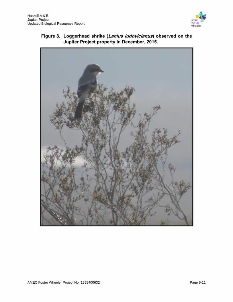
Haskell A & EJupiter ProjectUpdated Biological Resources Report
AMEC Foster Wheeler Project No. 1555400632 Page 5-11
Figure 8. Loggerhead shrike (Lanius ludovicianus) observed on theJupiter Project property in December, 2015.

Haskell A & EJupiter ProjectUpdated Biological Resources Report
AMEC Foster Wheeler Project No. 1555400632 Page 5-12
However, shrub interspaces were found dominated by dried, invasive, non-native annual grassesand forbs (i.e., red-stemmed stork’s bill and Mediterranean splitgrass). Red brome was notedbeneath some shrub canopies. Russian thistle, Sahara mustard (Brassica tournefortii) and redbrome were also observed along the shoulders of Navajo Road.
5.7 Habitat Connectivity and Corridors
Largely open, undeveloped lands border this property on the west, south and east, whichgenerally allow for terrestrial wildlife movement onto the parcel. Substantial, but relatively porous,barriers to certain terrestrial wildlife travel onto lands which border the subject property include I-15 and Dale Evans Parkway to the west, Stoddard Wells Road to the northwest and Navajo Roadto the east; the chain-link fenced Walmart Distribution Center, several buildings and the BlackMountain Quarry Railroad to the north; and the chain-link fenced Apple Valley County Airport tothe southeast.
The disconnected nature of these barriers, varying degree of terrestrial wildlife exclusion and thepresence of several culvert, bridge and drainage features which act as wildlife travel corridors,generally allow for habitat connectivity between the subject property and adjacent lands.

Haskell A & EJupiter ProjectUpdated Biological Resources Report
AMEC Foster Wheeler Project No. 1555400632 Page 6-1
6.0 CONCLUSIONS
The Jupiter Project site is located on private lands in northern Apple Valley, Californiawhich support a disturbed, moderate diversity creosote bush-white bursage alliance(Sawyer et al. 2009) with widely-spaced creosote bushes and considerable barren groundpunctuated with patches of annual grasses. Unpaved Burbank Avenue provides accessto this parcel and the immediate vicinity has been previously disturbed by domestic sheepgrazing, historic aerial military training and off-road vehicle travel.
Biological resources fieldwork was conducted on this property in April, May and December2015, including a general biological resources survey, a focused desert tortoise survey, ajurisdictional delineation of onsite streambeds and a desert kit fox burrowexcavation/collapse effort.
A branched and shallow, southwesterly-tending, ephemeral wash bisects the JupiterProject site property but does not to flow into a Traditionally Navigable Waterway; nor isany riparian or wetland vegetation present. The U.S. Army Corps of Engineers hasconfirmed that this wash is not a WUS and does not fall under their Clean Water Actjurisdiction This wash system is however, regulated by the Lahontan Regional WaterQuality Control Board (Region 6) under the California Water Code. The proposed Projectwas assessed as likely needing Waste Discharge Requirements and a Report of WasteDischarge has been filed with the RWQCB.. A 1602 Streambed Alteration Agreement withthe California Department of Fish and Wildlife was also assessed as necessary.Streambed Alteration Agreement Notification Number 1600-2015-0086-R6 has beensubmitted, which contains administrative, as well as impact avoidance and minimization,measures.
One loggerhead shrike, a California Species of Special Concern, was observed on theproperty. No state/federally listed species or any other special status species known fromthe region was observed on the property or adjacent lands. No Yucca species, cacti orother native plant specifically addressed by the California Native Plant Act or Town ofApple Valley General Plan were found to occur on the parcel.
Wildlife common to a Mojave Creosote Bush Scrub plant community (Holland 1986) werenoted on the subject property and surrounding lands. Eight inactive desert kit fox burrowswere recorded on the property. Desert kit fox activity was documented, but all recordeddesert kit fox burrows were confirmed as inactive. These burrows were excavated andcollapsed in December 2015 to prevent wildlife entry/occupation. Previously-used nestsconstructed by cactus wrens, as well as a small number of Joshua trees, were found tooccur on adjacent lands but not on the subject property.
No invasive, non-native animal species were observed on the subject property. Shrubinterspaces of the affected area were found dominated by several dried, invasive, non-native annual grasses and forbs. Several invasive non-native forbs were found to occuralong the shoulders of Navajo Road which is anticipated to be used as property access.

Haskell A & EJupiter ProjectUpdated Biological Resources Report
AMEC Foster Wheeler Project No. 1555400632 Page 6-2
Largely open, undeveloped lands border the subject property on the west, south and east,which generally allow for terrestrial wildlife movement onto the parcel.

Haskell A & EJupiter ProjectUpdated Biological Resources Report
AMEC Foster Wheeler Project No. 1555400632 Page 7-1
7.0 RECOMMENDATIONS
Worker environmental awareness program (WEAP) training should be provided to allpersons employed in proposed Project construction prior to their performing work on-site.This program should consist of a presentation from a qualified biologist that outlines deserttortoise information, project-specific protective measures and which provides instructionon what construction personnel are to do if a desert tortoise is encountered.
A pre-construction biological survey should be undertaken in the in the area proposed forfacility installation prior to general surface-disturbance and vegetation removal activitiestaking place, to ensure desert tortoises, burrowing owls, kit fox and migratory birds wouldnot be harmed. Fencing of the proposed construction and equipment staging area shouldalso be considered using agency-approved 1 by 2 in tortoise exclusion mesh fencinginstalled along the bottom of chain-link fencing, to minimize the potential for travel intoactive work areas by tortoise and other terrestrial animals.
A pre-construction animal burrow excavation effort should be undertaken, if any burrow isdiscovered during the pre-construction biological survey, to ensure no occupying tortoise,burrowing owl or kit fox would be adversely affected by planned surface disturbance. Anytortoises found should be translocated to native habitat areas located adjacent to the areaproposed for facility installation; or alternate area as approved by the involved regulatoryagencies. It should be noted that any harm, harassment, translocation or tortoise “take”of any kind requires an incidental take permit as outlined in the ESA/CESA.
A trash abatement plan should be developed and employed during Project construction,should this proposed facility be authorized. Trash and food items should be contained inclosed (raven-proof) containers and removed daily to avoid attracting opportunisticpredators of tortoises such as common raven, coyote, and feral dog.

Haskell A & EJupiter ProjectUpdated Biological Resources Report
AMEC Foster Wheeler Project No. 1555400632 Page 8-1
8.0 REFERENCES
AMEC Earth & Environmental Inc. (AMEC). 2006. Watson Land Company parcels 1, 2, 3, and10, Apple Valley, California biological resources assessment report. Riverside, CA.
Amec Foster Wheeler. 2015a. Jupiter Project San Bernardino County, California generalbiological resources survey report. Riverside, CA.
_____. 2015b. Jupiter Project San Bernardino County, California focused desert tortoise(Gopherus agassizii) survey report. Riverside, CA.
_____. 2015c. Jurisdictional delineation report, project Jupiter, Town of Apple Valley, SanBernardino County, California. Riverside, CA.
_____. 2015d. Jupiter Project San Bernardino County, California desert kit fox (Vulpes macrotis)monitoring & burrow excavation report. Riverside, CA.
American Ornithologists’ Union. 1998. Checklist of North American Birds. 7th ed. Am.Ornithological Union, Washington, D.C.
Baldwin, B.G., S. Boyd, B.J. Ertter, R.W. Patterson, T.S. Rosatti, and D.H. Wilken. 2002. TheJepson desert manual: vascular plants of southeastern California. University of CaliforniaPress. Berkeley, CA.
Bancroft, G. 1923. Some geographic notes on the cactus wren. Condor 25: 165-168.
Barrows, C.W. 1989. Diets of five species of desert owls. W. Birds 20:1-10.
Bent, A.C. 1948. Life histories of North American nuthatches, wrens, thrashers, and their allies.U.S. Nat. Mus. Bull No. 195.
Berry, K.H. 1985. Avian predation on the desert tortoise (Gopherus agassizii) in California. Bureauof Land Management, California Desert District, Moreno Valley, California.
Boarman, W.I. 1993. When a native predator becomes a pest: a case study. In: S. K. Majumdar,E. W. Miller, D. E. Miller, E. K. Brown, J. R. Pratt, and R. F. Schmalz (eds.), Conservationand resource management. Pennsylvania Acad. Sci., Philadelphia, PA.
_____. 2002. Desert tortoise Gopherus agassizii. In W.I. Boarman and K. Beaman, eds., “TheSensitive Plant and Animal Species of the Western Mojave Desert”. U.S. GeologicalSurvey, Western Ecological Research Center.http://www.blm.gov/pgdata/etc/medialib//blm/ca/pdf/pdfs/cdd_pdfs.Par.e5992b21.File.pdf/dta.pdf.
Boarman, W.I. and M. Sazaki. 2006. A highway’s road-effect zone for desert tortoises (Gopherusagassizii). Journal of Arid Environments 65:94-101.

Haskell A & EJupiter ProjectUpdated Biological Resources Report
AMEC Foster Wheeler Project No. 1555400632 Page 8-2
Boarman, W.I., M. Sazaki, and W.B. Jennings. 1997. The effect of roads, barrier fences, andculverts on desert tortoise populations in California, USA. Pages 54-58 in J. Van Abbema(ed.), Proceedings of the International Conference on Conservation, Restoration, andManagement of Tortoises and Turtles. New York Turtle and Tortoise Society, New York,NY.
Bossard, C.C., J.M. Randall, and M.C. Hoshovsky. 2000. Invasive plants of California’s wildlands.University of California Press, Berkeley, CA.
Brady, R. H. III, K. Vyverberg. 2013. Methods to describe and delineate episodic streamprocesses on arid landscapes for permitting utility-scale solar power plants. PublicationNumber: CEC-500-2014-013. California Energy Commission. Sacramento, CA.http://www.energy.ca.gov/2014publications/CEC-500-2014-013/CEC-500-2014-013.pdf.
Brooks, M.L., C.M. D’Antonio, D.M. Richardson, J.M. DiTomaso, J.B. Grace, R.J. Hobbs, J.E.Keeley, M. Pellant and D. Pyke. 2004. Effects of invasive alien plants on fire regimes.BioScience 54:677-688.
Bureau of Land Management (BLM). 1979. Tortoise density in the California Desert ConservationArea. California Desert Conservation Area Management Plan Plate 2-2. California DesertDistrict, Moreno Valley, CA.
_____. 1980. California Desert Conservation Area plan 1980. California Desert District, MorenoValley, CA.
_____. 1989. California Desert Conservation Area 1988 Desert tortoise habitat (interim map).California Desert District, Moreno Valley, CA.
_____. 1999. California Desert Conservation Area plan 1980, as amended. California DesertDistrict, Moreno Valley, CA.
_____. 2005. Final environmental impact report and statement for the West Mojave plan, a habitatconservation plan and California Desert Conservation Area plan amendment. CaliforniaDesert District, Moreno Valley, CA.http://www.blm.gov/ca/pdfs/cdd_pdfs/wemo_pdfs/plan/wemo/Vol-1-Chapter1_Bookmarks.pdf.
Bureau of Land Management (BLM) and California Department of Fish and Game (CDFG). 1992.California statewide desert tortoise management policy. BLM, California Desert District,Moreno Valley, CA.
California Department of Fish and Game (CDFG). 2003. Birds. Page 32 in “Atlas of the biodiversityof California.” Sacramento, CA.

Haskell A & EJupiter ProjectUpdated Biological Resources Report
AMEC Foster Wheeler Project No. 1555400632 Page 8-3
_____. 2010. A review of stream processes and forms in dryland watersheds. Prepared by K.Vyverberg, Conservation Engineering. 32 p. Sacramento, CA.http://search.aol.com/aol/search?s_it=topsearchbox.search&v_t=keyword_rollover&q=A+review+of+stream+processes+and+forms+in+dryland+watersheds.
_____. 2011. Special animals (883 taxa). Sacramento, CA.http://www.dfg.ca.gov/biogeodata/cnddb/pdfs/SPAnimals.pdf.
_____. 2012. Staff report on burrowing owl mitigation. Sacramento, CA.http://search.aol.com/aol/search?q=Staff%20report%20on%20burrowing%20owl%20mitigation&s_it=keyword_rollover&ie=UTF-8&VR=3430.
California Department of Fish and Wildlife (CDFW). 2015a. Fish and Game Code of California.http://www.leginfo.ca.gov/calaw.html. Sacramento, CA.
_____. 2015b. Streambed alteration agreement notification no. 1600-2015-0086-R6 (unsigned).City of Apple Valley, Project Jupiter. Inland Deserts Region. Ontario, CA.
_____. 2016a. State & federally listed endangered and threatened animals of California (March2015). Sacramento, CA.http://www.dfg.ca.gov/biogeodata/cnddb/pdfs/TEAnimals.pdf.
_____. 2016b. State and federally listed endangered, threatened, and rare plants of California(January 2015). Sacramento, CA.http://www.dfg.ca.gov/biogeodata/cnddb/pdfs/TEPlants.pdf.
_____. 2016c. Special animals list (January 2016). California Natural Diversity Database.Sacramento, CA. https://nrm.dfg.ca.gov/FileHandler.ashx?DocumentID=109406&inline.
_____. 2016d. California natural diversity database quick viewer report for the Apple Valley Northquadrangle. Sacramento, CA.http://imaps.dfg.ca.gov/viewers/cnddb_quickviewer/app.asp (Apple Valley North).
_____. 2016e. RAREFIND version 3.1.0 commercial program (Apple Valley North). Sacramento,CA.
Campbell, K.F. 1998a. Burrowing owl Athene cunicularia. Species account in the Bureau of LandManagement’s (2005) “Final Environmental Impact Report and Statement for the WestMojave Plan, a Habitat Conservation Plan and California Desert Conservation Area PlanAmendment”. U.S. Department of the Interior, BLM California Desert District, MorenoValley, CA.http://www.blm.gov/pgdata/etc/medialib//blm/ca/pdf/pdfs/cdd_pdfs.Par.a238d092.File.pdf/Buow1.pdf.
Haskell A & EJupiter ProjectUpdated Biological Resources Report
AMEC Foster Wheeler Project No. 1555400632 Page 8-4
_____. Loggerhead shrike Lanius ludovicianus. Species account in the Bureau of LandManagement’s (2005) “Final Environmental Impact Report and Statement for the WestMojave Plan, a Habitat Conservation Plan and California Desert Conservation Area PlanAmendment”. U.S. Department of the Interior, BLM California Desert District, MorenoValley, CA.http://www.blm.gov/style/medialib//blm/ca/pdf/pdfs/cdd_pdfs.Par.c6b490d3.File.pdf/Losh1.pdf.
Clinton, W.J. 1999. Executive Order 13112. Invasive species. 64 FR 6183. Washington D.C.http://www.gpo.gov/fdsys/pkg/FR-1999-02-08/pdf/99-3184.pdf.
_____. 2001. Executive Order 13186. Responsibilities of federal agencies to protect migratorybirds. 66 FR 3853. Washington D.C.http://www.gpo.gov/fdsys/pkg/WCPD-2001-01-15/pdf/WCPD-2001-01-15-Pg77.pdf.
Cypher, B.L. 2003. Foxes. Pp. 511-546 in G.A. Feldhamer, B.C. Thompson and J.A. Chapman(eds.), “Wild Mammals of North America: Biology, Management, and Conservation”. TheJohns Hopkins University Press, Baltimore, MD.
Cypher, B.L., S.C. McMillin, T.L. Westall, C. Van Horn Job, R.C. Hosea, B.J. Finlayson, and E.C.Kelly. 2014. Rodenticide exposure among endangered kit foxes relative to habitat use inan urban landscape. Cities and the Environment 7(1): Article 8.
Cypher, B.L., S.E. Phillips, and P.A. Kelly 2013. Quantity and distribution of suitable habitat forendangered San Joaquin kit foxes: conservation implications. Canid Biology andConservation 16.: 25-31.
Cypher, B.L., and K.A. Spencer. 1998. Competitive interactions between coyotes and SanJoaquin kit fox. Journal of Mammalogy 79: 204-214.
Cypher, B.L., G.D. Warrick, M.R. Otten, T.P. O'Farrell, W.H. Berry, C.E. Harris, T.T. Kato, P.M.McCue, J.H. Scrivner, and B.W. Zoellick. 2000. Population dynamics of San Joaquin kitfoxes at the Naval Petroleum Reserves in California. Wildlife Monographs 145.
Egoscue, H.J. 1956. Preliminary studies of the kit fox in Utah. Journal of Mammalogy 37: 351-357.
_____. 1962. Ecology and life history of the kit fox in Tooele County, Utah. Ecology 43: 481-497.
Elbroch, M. 2003. Kit or swift fox. Pp. 141-143 in “Mammal tracks and sign. A guide to NorthAmerican species.” Stackpole Books. Mechanicsburg, PA.
Golightly Jr., R.T., and R.D. Ohmart 1984. Water economy of two desert canids: coyote and kitfox. Journal of Mammalogy 65: 51-58.

Haskell A & EJupiter ProjectUpdated Biological Resources Report
AMEC Foster Wheeler Project No. 1555400632 Page 8-5
Garrett, K., and J. Dunn. 1981. Birds of southern California: status and distribution. Los AngelesAudubon Society, Los Angeles, California.
Gervais, J.A., D.K. Rosenberg, and L.A. Comrack. 2008. Burrowing owl Athene cunicularia. InShuford and Gardali (eds.) California Bird Species of Special Concern: A RankedAssessment of Species, Subspecies, and Distinct Populations of Birds of ImmediateConservation Concern in California. California Dep. Of Fish and Game, Sacramento, CA.
Green, G.A., Fitzner, R.E., Anthony, R.G., and Rogers, L.E. 1993. Comparative diets of burrowingowls in Oregon and Washington. Northwest Sci. 67:88–93.
Grinnell, J., and A.H. Miller. 1944. The distribution of the birds of California. Pacific CoastAvifauna No. 27.
Hall, E.R. 1981. The Mammals of North America. John Wiley and Sons, New York, USA.
Hamilton, R.A., G.A. Proudfoot, D.A. Sherry, and S. Johnson. 2010. Cactus wren(Campylorhynchus brunneicapillus). In A. Poole (ed.) “The Birds of North America Online”.Cornell Lab of Ornithology. Ithaca, NY.http://bna.birds.cornell.edu/bna/species/558/articles/introduction.
Haug, E.A., B.A. Milsap, and M.S. Martell. 1993. Burrowing owl (Speotyto cunicularia). In: A.Poole and F. Gill (eds.), The Birds of North America, No. 61. The American Ornithologists’Union, Philadelphia: The Academy of Natural; Sciences; Washington D.C.
Hickman, J. C. (ed.). 1993. The Jepson manual of higher plants of California. University ofCalifornia Press, Berkeley, CA.
Holland, R.F. 1986. Preliminary descriptions of the terrestrial natural communities of California.Nongame Heritage Program, California Department of Fish and Game. Sacramento, CA.http://www.cal-ipc.org/ip/inventory/pdf/HollandReport.pdf.
Jacobson, E.R., et al. 1991. Jacobson, E.R., Gaskin, J.M., Brown, M.B., Harris, R.K., Gardiner,C.H., LaPointe, J.L., Adams, H.P., Reggiardo, C., 1991. Chronic upper respiratory tractdisease of free-ranging desert tortoises (Xerobates agassizii). Journal of Wildlife Diseases27, 296–316.
Johnson, A.J., D.J. Morafka, and E.R. Jacobson. 2006. Seroprevalence of Mycoplasma agassiziiand tortoise herpesvirus in captive desert tortoises (Gopherus agassizii) from the GreaterBarstow Area, Mojave Desert, California. Journal of Arid Environments 67:192-201.
Koopman, M.E., B.L. Cypher, and J.H. Scrivner, 2000. Dispersal patterns of San Joaquin kit foxes(Vulpes macrotis mutica). Journal of Mammalogy 81: 213-222.
Koopman, M.E., J.H. Scrivner, and T.T. Kato. 1998. Patterns of den use by San Joaquin kitfoxes. Journal of Wildlife Management 62: 373-379.

Haskell A & EJupiter ProjectUpdated Biological Resources Report
AMEC Foster Wheeler Project No. 1555400632 Page 8-6
Kozlowski, A.J., E.M. Gese, and W.M. Arjo. 2008. Niche overlap and resource partitioningbetween sympatric kit foxes and coyotes in the Great Basin Desert of western Utah.American Midland Naturalist 160: 191-208.
McGrew, J.C. 1977. Distribution and habitat characteristics of the kit fox (Vulpes macrotis) in Utah.Utah State University. Logan, UT.
McGrew, J.C. 1979. Vulpes macrotis. Mammalian Species 123: 1-6.
Morrell, S. 1972. Life history of the San Joaquin kit fox. California Fish and Game 58: 162-174.
Munsell Color Laboratory. 2000. Munsell color charts. Gretag/Macbeth. New Windsor, NY.
Natural Resources Conservation Service (NRCS). 2013. Web soil survey. Prepared by SoilSurvey Staff, United States Department of Agriculture, NRCS. Washington D.C.http://websoilsurvey.nrcs.usda.gov/ (Accessed 11 May 2015).
O'Farrell, T.P. 1987. Kit fox. Pp. 423-431 in M. Novak, G.A. Baker, M.E. Obbard and B. Malloch(eds.), “Wild furbearer management and conservation in North America”. Ontario Ministryof Natural Resources and the Ontario Trappers Association. Toronto, Ontario, Canada.
Lambert, A.M., C.M. D’Antonio, and T.L. Dudley. 2010. Invasive species and fire in Californiaecosystems. Fremontia 38:29-36.http://www.cnps.org/cnps/conservation/pdf/fire/frem38.2_38.3_lambert_etal.pdf.
LaRue, E.L., Jr. 1993. Distribution of desert tortoise sign adjacent to Highway 395, SanBernardino County, California. Proceedings of the Desert Tortoise Council Symposium1993:190-204.
Lichvar, R.W., M. Butterwick, N.C. Melvin, and W.N. Kirchner. 2014. The National Wetland PlantList: 2014 Update of Wetland Ratings. Phytoneuron 2014-41: 1-42.
Milne, L., and M. Milne. 1992. The Audubon Society field guide to North American insects andspiders (11th printing). Published by Alfred A. Knopf, Inc. and copyrighted by ChanticleerPress, Inc. New York, NY.
National Oceanic and Atmospheric Administration (NOAA). 2015. Daily weather records forBarstow California. Washington D.C.http://www.ncdc.noaa.gov/cdo-web/datatools/records (Barstow, CA).
National Geographic Society. 2008. Field guide to the birds of North America, fifth edition (secondprinting). J.L. Dunn and J. Alderfer (eds.). The National Geographic Society, WashingtonD.C.
Phillips, B.G. 1992. Status of non-native plant species, Tonto National Monument, Arizona. TheUniversity of Arizona, School of Renewable Natural Resources, Cooperative National ParkResources Study Unit, Tucson, AZ.
Haskell A & EJupiter ProjectUpdated Biological Resources Report
AMEC Foster Wheeler Project No. 1555400632 Page 8-7
Polite, C., and J. Pratt. Golden eagle Aquila chrysaetos. In Zeiner, D.C., W.F. Laudenslayer, Jr.,K.E. Mayer, and M. White (eds.) California's Wildlife. Vol. I-III. CDFG, Sacramento, CA.http://nrm.dfg.ca.gov/FileHandler.ashx?DocumentVersionID=17730.
Prescott, B.G. 1998. Le Conte’s thrasher Toxostoma lecontei. Species account in the Bureau ofLand Management’s (2005) “Final Environmental Impact Report and Statement for theWest Mojave Plan, a Habitat Conservation Plan and California Desert Conservation AreaPlan Amendment”. U.S. Department of the Interior, BLM California Desert District, MorenoValley, California.http://www.blm.gov/pgdata/etc/medialib//blm/ca/pdf/pdfs/cdd_pdfs.Par.570513cd.File.pdf/lecontes1.PDF.
Ralls, K., and P.J. White. 1995. Predation on San Joaquin kit foxes by larger canids. Journal ofMammalogy 76: 723-729.
Ralls, K., B.L. Cypher, and L.K. Spiegel. 2007. Social monogamy in kit foxes: formation,association, duration, and dissolution of mated pairs. Journal of Mammalogy 88: 1439-1446.
Ralls, K., K. Pilgrim, P.J. White, E.E. Paxinos, and R.C. Fleischer. 2001. Kinship, socialrelationships and den use in kit foxes. Journal of Mammalogy 82: 858-866.
Rea, A.M. 1986. Geographic variation (of Campylorhynchus brunneicapillum): (1) NW,peninsular, and insular races, (2) N and E (mainland) races. Pages 118-120 In A.R. Phillip’(ed.), “The known birds Middle and North America, Part I.” Denver, CO.
Rea, A. M. and K. Weaver. 1990 The taxonomy, distribution, and status of coastal CaliforniaCactus Wrens. Western Birds 21: 81-126.
Reid, F.A. 2006. A field guide to mammals of North America, 4th edition. Peterson Field GuideSeries, Houghton Mifflin Company, New York, NY.
Rogers, G.F. and J. Steele. 1980. Sonoran Desert fire ecology. In Proceedings of the Fire HistoryWorkshop. Department of Agriculture, Forest Service, Rocky Mountain Forest and RangeExperiment Station, Tucson, AZ.
Rosenberg, D.K., L.A. Trulio, D.H. Catlin, D. Chromczack, J.A. Gervais, N. Ronan, and K.A.Haley. 2007. The ecology of the burrowing owl in California. Unpublished report preparedfor the U.S. Bureau of Land Management. USDI Bureau of Land Management, BakersfieldField Office, Bakersfield, CA.http://people.oregonstate.edu/~rosenbed/articles/Ecology%20of%20Burrowing%20Owls%20In%20California%20Final%20Report%20March%202007.pdf.
San Bernardino County (SBC). 2006. Biologist qualifications & report protocol for biologicalassessment reports. Advance Planning Division, Land Use Services Department. SanBernardino, California.

Haskell A & EJupiter ProjectUpdated Biological Resources Report
AMEC Foster Wheeler Project No. 1555400632 Page 8-8
Sawyer, J.O., T. Keeler-Wolf, and J. Evens. 2009. A manual of California vegetation 2nd edition.California Native Plant Society, Sacramento, CA.http://www.dfg.ca.gov/biogeodata/vegcamp/veg_manual.asp.
Solek, C., and L. Szijj. 2004. Cactus Wren (Campylorhynchus brunneicapillus). In “The CoastalScrub and Chaparral Bird Conservation Plan: a strategy for protecting and managingcoastal scrub and chaparral habitats and associated birds in California.” CaliforniaPartners in Flight. http://www.prbo.org/calpif/htmldocs/scrub.html.
Spiegel, L.K. 1996. Studies of San Joaquin kit fox in undeveloped and oil-developed areas: anoverview. In: L.K Spiegel (ed.), “Studies of the San Joaquin kit fox in undeveloped and oil-developed areas”. California Energy Commission, Sacramento, CA.
Stebbins, R.C. 2003. A field guide to western reptiles and amphibians, 3rd edition. Peterson FieldGuide Series, Houghton Mifflin Company, New York, NY.
Terra Nova-Town of Apple Valley. 2009. General plan. Apple Valley, CA.http://www.applevalley.org/Index.aspx?page=687.
United States Army Corps of Engineers (USACE). 1987. Wetlands delineation manual, technicalreport Y-8. U.S. Army Engineers Waterways Experiment Station. Vicksburg, MS. 100 pp.+ append. http://el.erdc.usace.army.mil/elpubs/pdf/wlman87.pdf.
_____. 2007. Jurisdictional instructional form guidebook. U.S. Army Engineers WaterwaysExperiment Station. Vicksburg, MS.http://www.usace.army.mil/Portals/2/docs/civilworks/regulatory/cwa_guide/jd_guidebook_051207final.pdf.
_____. 2008a. A Field Guide to the Identification of the Ordinary High Water Mark (OHWM) in theArid West Region of the Western United States. A Delineation Manual. Cold RegionsResearch and Engineering Laboratory. Prepared by R.W. Lichvar and S.M. McColley.U.S. Army Engineer Research and Development Center. Hanover, NH.http://www.spk.usace.army.mil/Portals/12/documents/regulatory/pdf/Ordinary_High_Watermark_Manual_Aug_2008.pdf.
_____. 2008b. Regional Supplement to the Corps of Engineers Wetland Delineation Manual: AridWest Region. U.S. Army Engineers Waterways Experiment Station. Vicksburg, MS.http://el.erdc.usace.army.mil/elpubs/pdf/trel08-28.pdf.
U.S. Fish and Wildlife Service (USFWS). 1990. Endangered and threatened wildlife and plants;determination of threatened status for the Mojave population of the desert tortoise. FederalRegister 55(63): 12178-12191.
_____. 1994a. Final rule: determination of critical habitat for the Mojave population of the deserttortoise. Federal Register 59 (26):5820-5866.
Haskell A & EJupiter ProjectUpdated Biological Resources Report
AMEC Foster Wheeler Project No. 1555400632 Page 8-9
_____. 1994b. Desert tortoise (Mojave population) recovery plan. USFWS, Portland, OR. 73 ppplus appendices. http://ecos.fws.gov/docs/recovery_plans/1994/940628.pdf.
_____. 1994c. One year finding for a petition to list the Pacific coast population of the cactus wrenunder the Endangered Species Act. Federal Register Document 94-21785.
_____. 2003. Status assessment and conservation plan for the western burrowing owl in theUnited States. Biological Technical Publication BTP-R6001-2003. Shepherdstown, WV.http://www.fws.gov/mountain-prairie/species/birds/WBO/Western%20Burrowing%20Owlrev73003a.pdf.
_____. 2010a. Preparing for any action that may occur within the range of the Mojave deserttortoise (Gopherus agassizii). Ventura Field Office. Ventura, CA.http://www.fws.gov/ventura/speciesinfo/protocols_guidelines/docs/dt/DT%20Pre-project%20Survey%20Protocol_2010%20Field%20Season.pdf.
_____. 2010b. Mojave population of the desert tortoise (Gopherus agassizii), 5-year summaryreview: summary and evaluation. Desert Tortoise Recovery Office. Reno, NV.http://ecos.fws.gov/docs/five_year_review/doc3572.DT%205Year%20Review_FINAL.pdf
_____. 2010c. General provisions; migratory birds revised list and permits; final rules. 50 Code ofFederal Regulations Parts 10 and 21. Federal Register 75 (39):9282-9314.
_____. 2011. Revised recovery plan for the Mojave population of the desert tortoise (Gopherusagassizii). USFWS, Desert Tortoise Recovery Office, Reno, NV.http://www.fws.gov/nevada/desert_tortoise/documents/recovery_plan/RRP%20for%20the%20Mojave%20Desert%20Tortoise%20-%20May%202011.pdf.
_____. 2015a. List of threatened, endangered, candidate and proposed species in SanBernardino County, California. Environmental Conservation Online System. USFWSHeadquarters. Falls Church, VA. http://ecos.fws.gov/tess_public/reports/species-by-current-range-county?fips=06071.
_____. 2015b. Critical Habitat Portal: San Bernardino County, California. EnvironmentalConservation Online System. USFWS Headquarters. Falls Church, VA.http://ecos.fws.gov/crithab/.
_____. 2015c. National Wetlands Inventory Mapper. USFWS Headquarters. Falls Church, VA.http://www.fws.gov/wetlands/Data/Mapper.html (Accessed 11 May 2015).
U.S. Geological Survey (USGS). 1970, rev. 1993. Apple Valley North, Calif. 34117-E2-TF-024.DMA 2553 II SW-Series V895. Denver, CO. http://www.usgs.gov/pubprod/index.html.
Weather Underground. 2015. Weather history website information for Apple Valley California.
Haskell A & EJupiter ProjectUpdated Biological Resources Report
AMEC Foster Wheeler Project No. 1555400632 Page 8-10
http://www.wunderground.com/history/airport/KBYS/2014/5/16/DailyHistory.html?req_city=NA&req_state=NA&req_statename=NA (Apple Valley, California).
Western Regional Climate Center (WRCC). 2015. Average total annual precipitation for AppleValley California (040244), period of record 6/1/1959-3/31/1987.http://www.wrcc.dri.edu/cgi-bin/cliMAIN.pl?ca0244.
White, P.J., and R.A. Garrott. 1997. Factors regulating kit fox populations. Canadian Journal ofZoology 75: 1982-1988.
White, P.J., K. Ralls, and C.A. Vanderbilt White. 1995. Overlap in habitat and food use betweencoyotes and San Joaquin kit foxes. Southwestern Naturalist 40: 342-349.
Zoellick, B.W., C.E. Harris, B.T. Kelly, T.P. O’Farrell, T.T. Kato, and M.E. Koopman. 2002.Movements and home ranges of San Joaquin kit foxes relative to oil-field development.Western North American Naturalist 62: 151-159.
Zoellick, B.W., T.P. O’Farrell, P.M. McCue, C.E. Harris, and T.T. Kato. 1987. Reproduction of theSan Joaquin kit fox on Naval Petroleum Reserve #1, Elk Hills, California, 1980-1985. U.S.Department of Energy Topical Report. Washington D.C.
14 California Code of Regulations (CCR). § 460 (Fisher, Marten, River Otter, Desert Kit Fox andRed Fox).https://govt.westlaw.com/calregs/Document/I729002739AE04E9B9C0DFAA95E73577B?viewType=FullText&originationContext=documenttoc&transitionType=CategoryPageItem&contextData=(sc.Default).
Yosef, R. 1996. Loggerhead Shrike (Lanius ludovicianus). In: A. Poole and F. Gill (eds.), “TheBirds of North America, No. 231.” The Academy of Natural Sciences, Philadelphia,Pennsylvania, and The American Ornithologists’ Union, Washington, D.C.

Haskell A & EJupiter ProjectUpdated Biological Resources Report
AMEC Foster Wheeler Project No. 1555400632 Page 8-1
9.0 CERTIFICATION
CERTIFICATION: “I hereby certify that the statements furnished above and in the attachedexhibits present the data and information required for this biological evaluation, and that the facts,statements, and information presented are true and correct to the best of my knowledge andbelief. Field work conducted for this assessment was performed by me or under my directsupervision. I certify that I have not signed a non-disclosure or consultant confidentialityagreement with the project applicant or applicant’s representative and that I have no financialinterest in the project.”
DATE: ______15 January 2016__________ SIGNED: /s/ Thomas Egan________Report Author
Resumes of involved biological personnel have been attached to this document as Appendix B.Include names and signatures for those performing fieldwork.
1) Biological Resources and Focused Desert Tortoise Survey Fieldwork Performed on 14-16 April2015 By:
/s/ Thomas Egan_____________
/s/ Susan Seville_____________
2) Jurisdictional Delineation Fieldwork Performed on 9 May 2015 By:
/s/ Scot Chandler_____________
3) Biological Resources and Focused Desert Tortoise Survey Fieldwork Performed on 2-8December 2015 By:
/s/ Thomas Egan_____________