jungbluth ditch notes - ohio epa€¦ · jungbluth ditch notes . u.s. army corps of engineers,...
TRANSCRIPT

SUBJECT: U.S. Army Corps of Engineers, Buffalo District - Survey of French Creek Final Report - July 2004
JUNGBLUTH DITCH NOTES

U.S. ARMY CORPS OF ENGINEERS, BUFFALO DISTRICT FRENCH CREEK WATERSHED SURVEY
FIELD NOTES AND PHOTOS
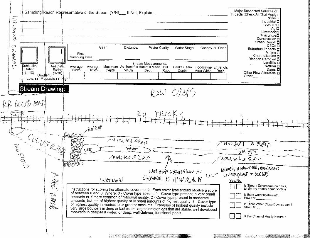
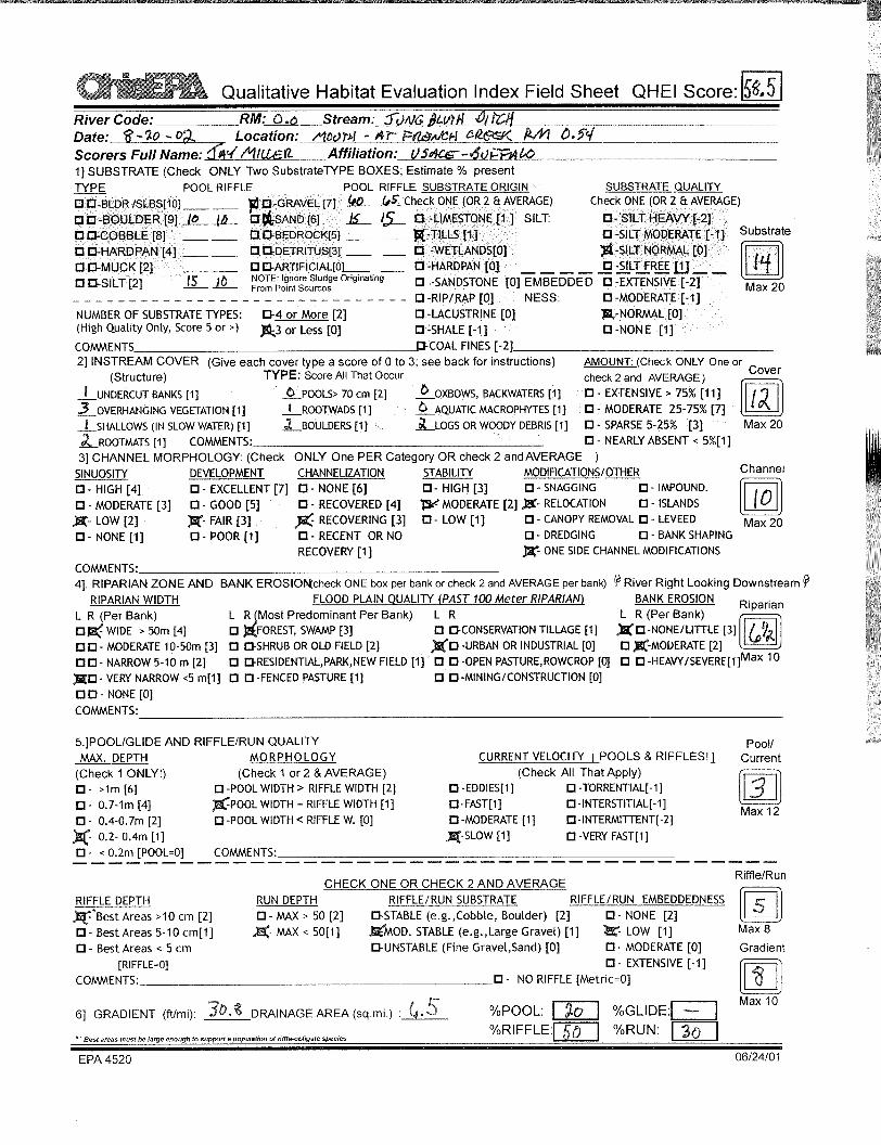
Stream Name and River Mile: Jungbluth Ditch 0.0 Stream Segment Location: Mouth of Ditch (French Creek RM 0.54) QHEI Score: 58.5 HHEI Score: NA FIELD NOTES: 20 AUG 2002 Jungbluth Ditch (a.k.a. Sugar Creek) enters French Creek immediately east of East River Road. The upland forested buffer on the west bank is narrow (20’) before encountering a gravel trail that parallels East River Road. The road is immediately adjacent to the trail. The east bank has a wide (>100m) forested buffer with dominant tree species including black walnut, white ash, sugar maple, sycamore, American hornbeam and eastern cottonwood. Macroinvertebrates were noted in the creek channel that was dominated by shale gravel with silt, sand and cobbles and concrete slabs. PHOTOS: No photo’s available.

U.S. ARMY CORPS OF ENGINEERS, BUFFALO DISTRICT FRENCH CREEK WATERSHED SURVEY
FIELD NOTES AND PHOTOS
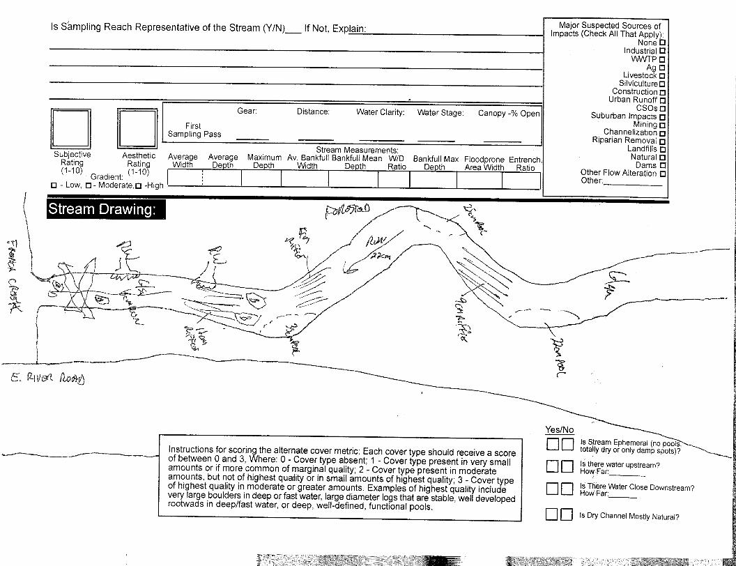
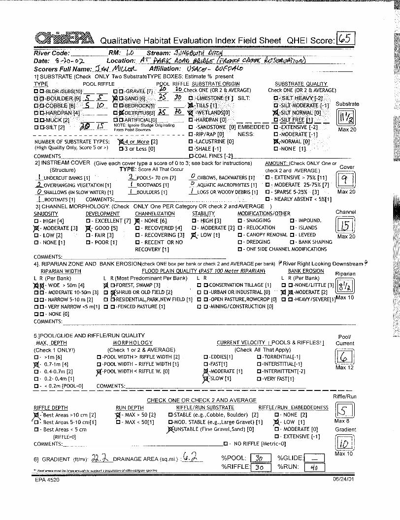
Stream Name and River Mile: Jungbluth Ditch 1.0 Stream Segment Location: Upstream of Park Road Bridge QHEI Score: 65 HHEI Score: NA FIELD NOTES: 20 AUG 2002 This portion of Jungbluth Ditch is located on the east side of the French Creek Reservation Park Road Bridge. Minnows and macroinvertebrates were noted in this stretch. Loose, sandy substrate was noted immediately east of the bridge. The overall substrate is dominated by sand and detritus, with gravel, cobbles, boulders, and silt. The wide forested riparian buffers on both sides of the creek are dominated by sugar maple and shagbark hickory. A roadside ditch follows southward along Park Road and enters the creek near the bridge. The sinuous creek has 4-8’ banks on either side. PHOTOS:
1) Jungbluth Ditch 1.0 – Facing upstream from bridge

2) Jungbluth Ditch 1.0 – Facing downstream towards bridge


U.S. ARMY CORPS OF ENGINEERS, BUFFALO DISTRICT FRENCH CREEK WATERSHED SURVEY
FIELD NOTES AND PHOTOS
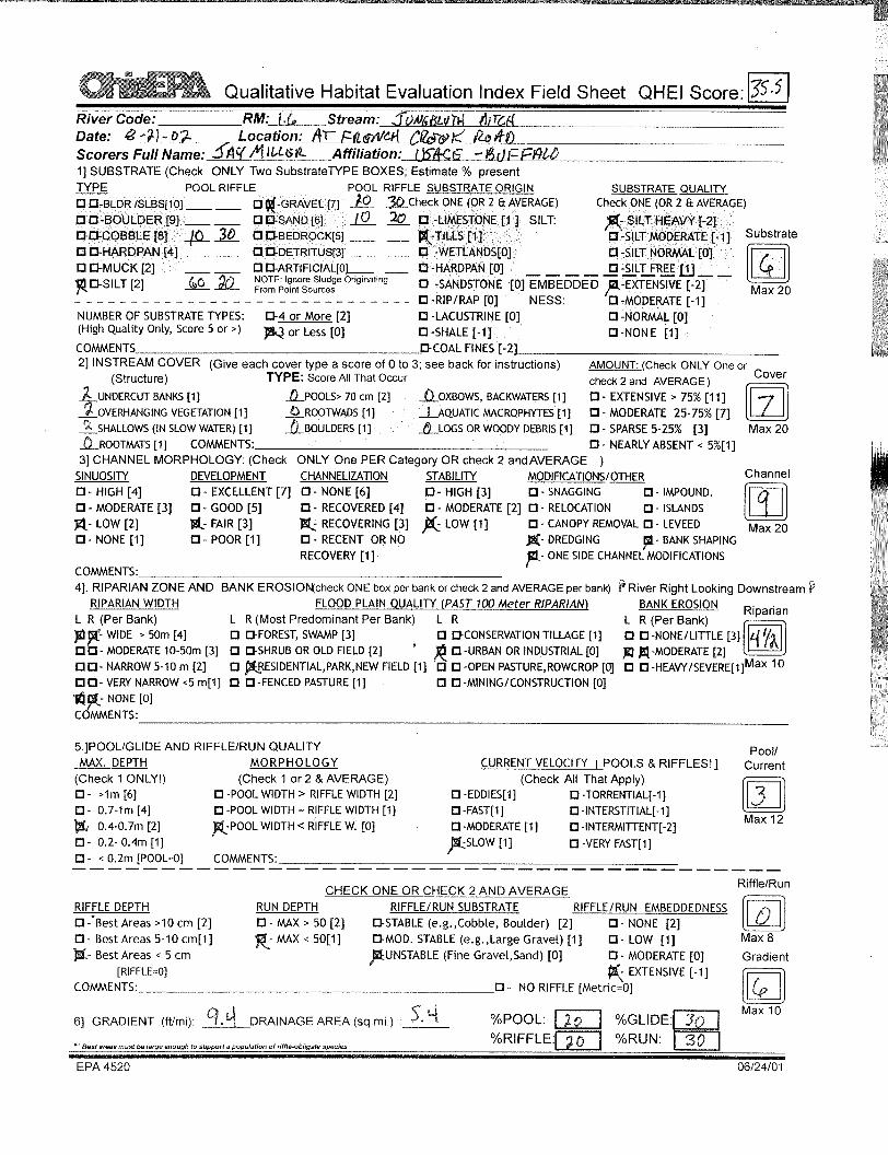
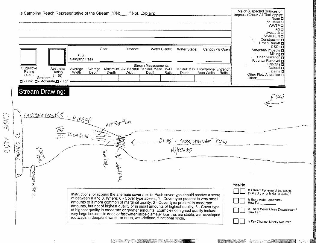
Stream Name and River Mile: Jungbluth Ditch 1.6 Stream Segment Location: At French Creek Road QHEI Score: 35.5 HHEI Score: NA FIELD NOTES: This section of Jungbluth Ditch is located on the south side of French Creek Road. The ditch has been dredged and maintained with a 6’+/- mowed strip on the east side. The channel is straight and consistent in depth. The west side of the ditch has a wide shrub buffer dominated by silky dogwood, gray-stemmed dogwood, and northern arrowwood. The eastern fringe of the channel is dominated by purple loosestrife. The water depth generally ranges from 40-50 cm. This area has some potential for restoration. PHOTOS:
1) Jungbluth Ditch 1.6 – Facing upstream from bridge

2) Jungbluth Ditch 1.6 – Facing downstream


U.S. ARMY CORPS OF ENGINEERS, BUFFALO DISTRICT FRENCH CREEK WATERSHED SURVEY
FIELD NOTES AND PHOTOS
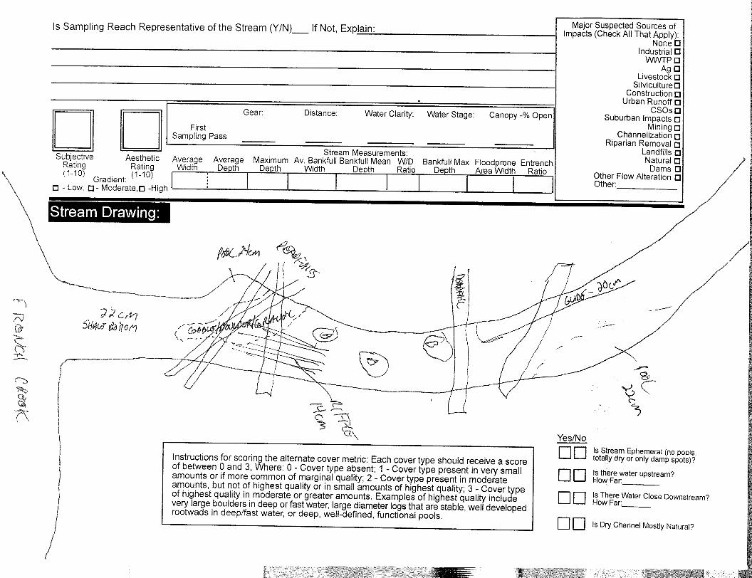
Stream Name and River Mile: Jungbluth Ditch 3.15 Stream Segment Location: At Abbe Road QHEI Score: 59 HHEI Score: NA FIELD NOTES: This site is a stretch of Jungbluth Ditch that flows adjacent to Abbe Road before flowing under a bridge and to the northwest. A 6’ high retaining wall along Abbe Road forms the west bank. There is virtually no vegetated buffer between the channel and the road. The channel is 8-10’ wide with pools ranging in depth from 12-55 cm. Many minnows were noted along with some macroinvertebrates. Patches of emergent vegetation including purple loosestrife and willow seedlings were noted along the channel fringes. The 50’+/- buffer along the east bank separates the creek channel from the residential subdivision to the east. The wooded buffer contains large American elm trees along with green ash, boxelders, pin oak, black willow and an understory of Canada goldenrod. Tile drains were noted discharging from the residences to the east. The substrate is dominated by gravel and cobble with occasional boulders and sand. Restoration opportunities are limited due to the location, however potential sources of contamination come from Abbe Road runoff and tile drain discharge. PHOTOS:
1) Jungbluth Ditch 3.15 – Facing south along Abbe Road from bridge

2) Jungbluth Ditch 3.15 – Facing north


U.S. ARMY CORPS OF ENGINEERS, BUFFALO DISTRICT
FRENCH CREEK WATERSHED SURVEY
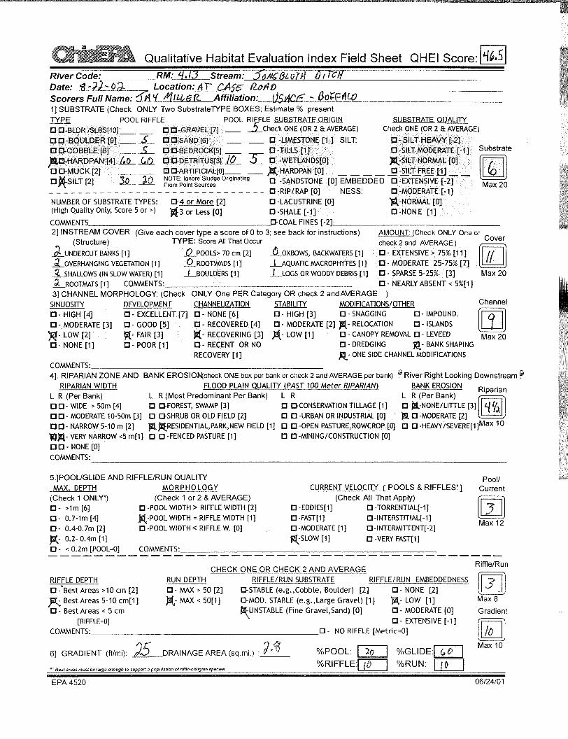
FIELD NOTES AND PHOTOS Stream Name and River Mile: Jungbluth Ditch 4.13 Stream Segment Location: At Case Road QHEI Score: 46.5 HHEI Score: NA FIELD NOTES: 22 AUG 2002 This stretch of Jungbluth Ditch is on the northeast branch that crosses Case Road north of the Camelot subdivision. The northeast bank is adjacent to a residence (lawn) and has no buffer for the first 50’. The remainder of the northeast bank as well as the southwest bank has a narrow (10-20’) vegetated buffer with eastern cottonwood, black willow, red maple, green ash, multiflora rose, gray-stemmed dogwood and black cherry. There is a 6” culvert under Case Road and a 12” tile pipe discharging from the lot to the south. The channel is 2-8’ wide with riprap on the northeast bank. The water depth was 10-25 cm. over a mostly hardpan and silt substrate with occasional cobbles, gravel and detritus. Rice cutgrass (emergent) and water milfoil (aquatic) were found in the channel intermittently. There are a few riffles. The ditch flows northward from Case Road through a residential area to the southeast. The ditch first flows through the Camelot subdivision where it has been rerouted and expanded into several detention/retention ponds. In addition, large areas have been underlain with culverts. This portion of the creek (subdivision) represents a significant impediment to fish/benthic habitat. PHOTOS:
1) Jungbluth Ditch 4.13 – On the northeast branch

2) Jungbluth Ditch 4.13 – At Case road – upstream

SUBJECT: U.S. Army Corps of Engineers, Buffalo District - Survey of French Creek Final Report - July 2004
WALKER DITCH NOTES

U.S. ARMY CORPS OF ENGINEERS, BUFFALO DISTRICT FRENCH CREEK WATERSHED SURVEY
FIELD NOTES AND PHOTOS
Stream Name and River Mile: Walker Ditch 0.0 Stream Segment Location: Mouth of Ditch (French Creek RM 1.23) QHEI Score: 66.5 HHEI Score: NA FIELD NOTES: 20 AUG 2002 Walker Ditch (a.k.a. Fish Creek) enters French Creek from the south and east. There is a 40’ bank on the south side of this stretch and a 15-20’ high bank on the north side. Both sides contain forested buffers (50’ wide to south; 100’ wide to north) dominated by sugar maple with occurrences of eastern cottonwood, red oak, black cherry, and American hornbeam. The substrate is dominated by gravel overlaying bedrock, with lesser amounts of boulders and sand. There appears to be less biological activity than in Jungbluth Ditch. PHOTOS:
1) Walker Ditch 0.0 – Facing upstream (200’ from mouth)


U.S. ARMY CORPS OF ENGINEERS, BUFFALO DISTRICT FRENCH CREEK WATERSHED SURVEY
FIELD NOTES AND PHOTOS
Stream Name and River Mile: Walker Ditch 0.6 Stream Segment Location: At end of FCNP Hiking Trail QHEI Score: 67 HHEI Score: NA FIELD NOTES: 20 AUG 2002 This section of Walker Ditch is located off a trail in French Creek Reservation Park. The substrate is dominated by gravel and sand with bedrock, silt, boulders and cobbles. The banks range from 2-15’ in height. The wide, mature forested upland riparian area is dominated by sugar maple with red oak, black cherry, cottonwood and beech. Frogs, macroinvertebrates and deer were noted. Gliceria was noted on the fringes of the creek channel. A red cardinal flower was noted on a gravel bar. PHOTOS:
1) Walker Ditch 0.6 – Facing upstream from trail
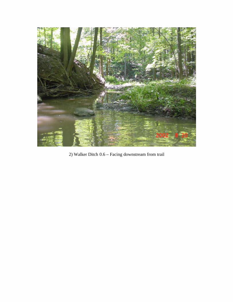
2) Walker Ditch 0.6 – Facing downstream from trail


U.S. ARMY CORPS OF ENGINEERS, BUFFALO DISTRICT FRENCH CREEK WATERSHED SURVEY
FIELD NOTES AND PHOTOS
Stream Name and River Mile: Walker Ditch 1.7 Stream Segment Location: At Abbe Road QHEI Score: 23 HHEI Score: NA FIELD NOTES: 21 AUG 2002 This site is located on the west side of Abbe Road immediately north of the railroad tracks. This section of Walker Ditch has been channelized. The channel width is 12’ and the water depth averages 15 cm. The channel contains emergent vegetation including duck potato, arrowhead, soft-stem bulrush, sedges and rushes. The south bank has a 15’+/- wide shrub/old field buffer between the channel and railroad tracks. A soybean field is located to the south of the railroad tracks. The north side has a shrub/old field area. Both buffers contain species including gray-stemmed dogwood and Canada goldenrod. A subclimax forest is located 30’ +/- to the north of the channel on the north side. This forest contains green ash and red maple. Approximately 400’ west of Abbe Road, a residential subdivision replaces the forested area on the north side. Tadpoles and macroinvertebrates were noted in the ditch. The substrate is dominated by silt and muck. Considering the location, this section of the ditch is in remarkably good shape, as there are very few occurrences of invasive species. PHOTOS:
1) Walker Ditch 1.7 – Facing downstream from Abbe Road

2) Walker Ditch 1.7 – Facing upstream