june 2019 - hgfc.org.uk files/stonechat 2019 june v2.pdf · 1 contents june 2019 2 editorial 3...
TRANSCRIPT
The Magazine of
Horsham Geological Field Club
June 2019
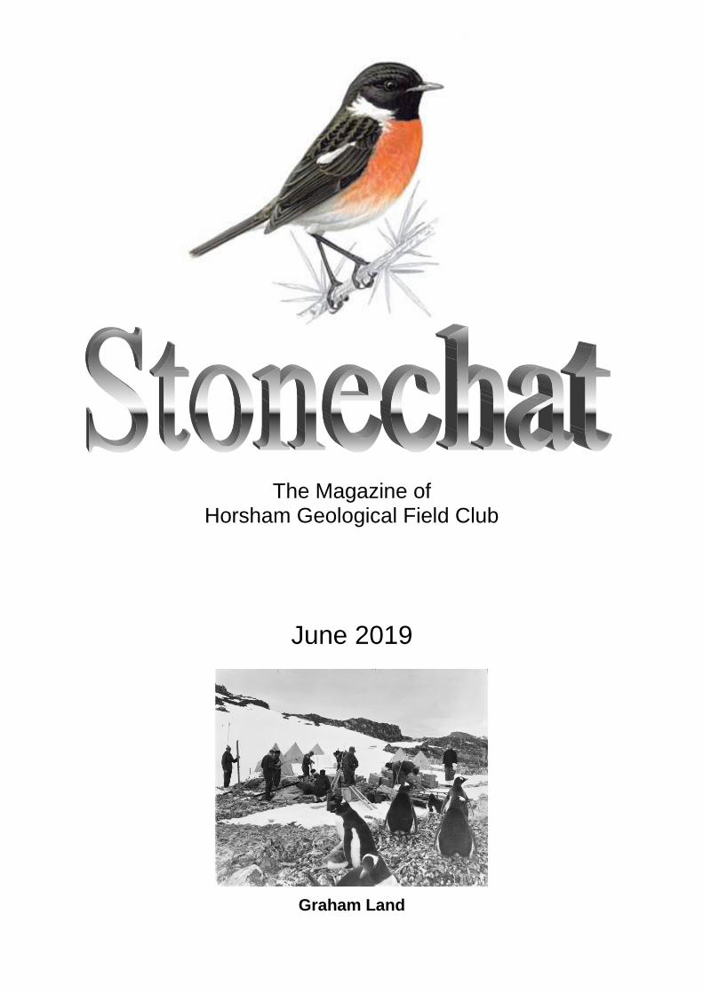
Graham Land

HORSHAM GEOLOGICAL FIELD CLUB OFFICERS AND COMMITTEE 2019/20
President Bob Chandler
Vice President Frank Diggon
Secretary Gill Woodhatch
Treasurer Gordon Judge
Lecture Programme Coordinator Vacancy
Field Trip Secretary Mike Webster
Magazine Editor Gordon Judge
Committee Member Beryl Jarvis Susan Reese
Subscription: £14 PER ANNUM (due 1 April) or £2 per lecture Stonechat paper copy: extra £2 per annum
WEB SITE : http://www.hgfc.org.uk
Many thanks to the folk in Forest School office, who produce the printed version of Stonechat for us.
1
CONTENTS
June 2019
2 Editorial
3 Christmas party 2018
4 Graham Land, Antarctic Peninsula - a geo/bio travelogue 8 On the fate of a Plate
9 SNIPPET: CORE TIME
10 The Chalk cliffs and shore platforms of Sussex
14 SNIPPET: HOW CLIMATE CHANGE AFFECTS YOUR COMPASS
15 Bill Bryson and the stromatolites of Shark Bay
17 SNIPPET: WHERE THE WATER IS
18 Green men, French food and Fossils: Brexit and the Bajocian
20 John ’Earthquake’ Milne
22 The roots of the Hercynian mountains
27 AGM 2019
29 Club programme 2019
There is nothing so wearisome, or so destructive to the human mind, as
the disease called "Nothing to do" There is always and everywhere something to be done; there are no two places in this world exactly alike in their products, animal, vegetable, or mineral, and the objects you do not find in one place you will find in another. If the eyes be instructed and trained to observe what is brought before their gaze, the mind is employed, and the feeling of weariness passes off: one fact follows
another; a new observation may be tacked on to an old observation; the result being not only pleasure in discovery, but pleasure in recollecting
and recording.
Frank Buckland, Curiosities of natural history,1860

2
Editorial
Congratulations to our Club President, Bob Chandler FGS, who was awarded a PhD on 3 December 2018 by the University of Portsmouth. The truly memorable title of his thesis was ‘High resolution biostratigraphy and biochronology of the Aalenian and Bajocian stages (Middle Jurassic) of Dorset and Somerset UK'. As Bob commented, "It was the culmination of 50 years work on the Inferior Oolite." After months of vainly hoping for a volunteer to replace her (but gamely carrying on doing the job anyway), Beryl Jarvis has now relinquished the business of organising speakers for our meetings. She is happy to carry on identifying speakers, but we need one or more people to do the speaker-liaison, speaker-ferrying and publicity jobs. Please talk to Beryl or Gill if you would like to help in one or more of these areas. The Club Committee has now shrunk to just five people. Bearing in mind that two of them, covering four rôles between them, were out of action for parts of the last year, we really need a few more members on the Committee to improve its resilience and help make decisions about what the Club does. On the positive side, Field Trip Secretary Mike Webster continues to arrange joint trips with other clubs, as you will see on the Club website. If you haven’t yet experienced a field trip, do read Gill’s encouraging endorsement in the AGM report on page 27 and join in! And Alan Simmonds has joined the Stonechat writing team; his first report will appear in the December issue. I recently read Bill Bryson’s book Down Under and was so impressed with his description, in the inimitable Bryson style of science mixed with gentle humour, of a visit to Australia’s Shark Bay and its stromatolites, that I sought permission to reproduce it for your delectation. You’ll find it on page 15. It fits well with the wide geographical scope of the other articles in this issue: Western Australia, the Sussex coast, France, Japan, the Isle of Wight and Southwest England!
Back
3
Christmas party 2018 by Gordon Judge
As Stonechat reports of past Christmas parties have frequently hinted, when Club members celebrate they tend to do so in a manner that only they would describe as ‘celebrating’. A knees-up without the knees. And without the up. This year, the first challenge was to locate the venue in the dark and the rain, along narrow country lanes with edges often obscured by leaves. Not the usual one, then, but the Reece’s house in Park Lane, Maplehurst. Resourceful as ever, 21 members succeeded, only for some to then find themselves having to negotiate for chair space with our hosts’ two cats. As they were of mature age (the cats, not necessarily the members), a considerable degree of tact and compromise was called for. Once settled, we sat and admired the woodwork. (No, really – there was some beautiful bespoke oak carpentry around the place, much of it holding up the Reece book collection.) With food and drink piling up in the kitchen, the time came to relocate it and us to the dining room table. Somehow, the variety and quality of the cuisine provided by members was, as it always is, spectacular and more than sufficient to fill 21 HGFC stomachs. All went quiet – until Gill handed out the first of the dreaded brain-testing sheets – geo-anagrams (A GAME GROANS?). Much muttering and scribbling, interspersed by the occasional exclamation. Objections about “Yorkshire Lias” not being a recognised geological term were countered by the irrefutable fact that geologist Tim Ewin had used it in the title of last November’s talk. The second sheet, a quiz about the dates of historical events, served only to highlight our dismal recollection of such things. A nearby member was heard to claim that his brain had been occupied with the more urgent business of digestion. Nevertheless, prizes were awarded to the highest-scoring members for each mind-bending test. Members appeared reluctant to move on to the final test, the journey home; but the sound of the dishwasher in the kitchen being loaded persuaded us to depart. Many thanks to Sue for her hospitality, Beryl for the prizes, and members for the delicious fare.
Back
4
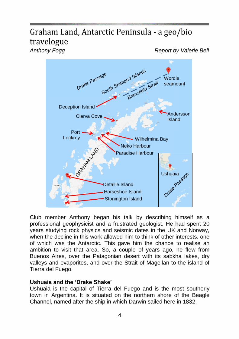
Graham Land, Antarctic Peninsula - a geo/bio travelogue Anthony Fogg Report by Valerie Bell
Club member Anthony began his talk by describing himself as a professional geophysicist and a frustrated geologist. He had spent 20 years studying rock physics and seismic dates in the UK and Norway, when the decline in this work allowed him to think of other interests, one of which was the Antarctic. This gave him the chance to realise an ambition to visit that area. So, a couple of years ago, he flew from Buenos Aires, over the Patagonian desert with its sabkha lakes, dry valleys and evaporites, and over the Strait of Magellan to the island of Tierra del Fuego. Ushuaia and the ‘Drake Shake’ Ushuaia is the capital of Tierra del Fuego and is the most southerly town in Argentina. It is situated on the northern shore of the Beagle Channel, named after the ship in which Darwin sailed here in 1832.
Wordie seamount
Horseshoe Island seamount Stonington Island seamount
Deception Island seamount
Detaille Island seamount
Cierva Cove seamount
Port Lockroy
Paradise Harbour
Ushuaia Cove
Andersson Island seamount
Neko Harbour
Wilhelmina Bay

5
Anthony boarded the ice-strengthened Ocean Endeavour, operated by Quark Expeditions. The ship crossed the Drake Passage which separates mainland South America and the Graham Land peninsula. The sea in this region can be very rough and is known as the ‘Drake Shake’. Here, the northward-flowing Antarctic waters meet the warmer waters of the subantarctic, bringing up food for the wildlife. Birds you might spot here include albatrosses and Cape petrels. Graham Land geology The Antarctic Treaty bans mineral extraction from the Antarctic area, so little geological work has been done since the 1950s and ’60s. Anthony explained that Graham Land’s origins lie in the ancient supercontinent of Gondwana. When Antarctica was joined to South America it underwent the same compressive forces that formed the Andes. Their separation around 30 Ma ago created the Drake Passage. Reflecting its origins, the geology of the Graham Land peninsula is volcanic. The youngest rocks are in the South Shetland Islands; in the south are the oldest rocks formed some 400–500 Ma ago. The main part of the peninsula was created around 180 Ma ago, when the former Phoenix Plate subducted below the Shetland Plate, forming a magmatic arc with
back-arc volcanism, originally on the peninsula’s eastern side. The arc had migrated to the western side by some 30 Ma later. Magmatism continued from the Jurassic into the Tertiary, generating a sequence of almost entirely volcanic rocks. The Bransfield Strait, between the South Shetlands and the Antarctic peninsula (see main map), is relatively young: its present-day volcanic activity is still creating new crust.
former Phoenix Plate subducted
below the Shetland plate
Tectonic boundaries near the South Shetland Islands
back-arc basin
spreading ridge
Part of Gondwana c.150 Ma, showing Antarctica still joined to South America

6
Ice In the Antarctic spring, access by ship to the peninsula is blocked by sea ice: it’s only possible between late January and March. Anthony showed a slide, taken near the Antarctic Circle, of a tilted iceberg showing its history as volcanic dust in a near-vertical line. Braving the
bitter winds (although the temperature was a balmy +1C), he left the ship in a tough Zodiac inflatable and spotted crab-eating seals (which don’t eat crabs) and leopard seals (who don’t like eating feathers). Detaille Island This small island (see main map) off the northern end of the Arrowsmith Peninsula in Graham Land contains many Jurassic rocks. Built in 1956, the huts here were the British Antarctic Survey’s ‘Station W’, and were occupied until 1959 doing research for the 1957–58 International Geophysical Year. It is now visited by cruise ships and the tourists can see the remains of the huts and some of the contents – tins, bottles and maps. Here the rocks are the remains of Jurassic volcanoes containing glacial striations. They consist of andesite and plagioclase phenocrysts (crystals in an igneous rock). Angular clasts having a range of sizes was evidence of pyroclastic flows; rounded clasts of different types probably indicated a debris flow. Andersson Island Upper Jurassic volcanic rocks again, with visible thermal margins around mafic dyke intrusions. Andersson Island was also home to some Adélie penguins, cormorants and Antarctic terns. Neko Harbour Anthony then travelled to Neko Harbour. Still more volcanic rocks but Lower Tertiary to Upper Cretaceous this time. This was discovered by a Belgian explorer in 1899 and named after a Norwegian whaling ship. It is part of the Antarctic mainland and is occupied by Gentoo penguins which seem to prefer triangular stones for nest building. Exposed on the shore are felsic granites, possible indicating two phases of intrusion. Port Lockroy The next port of call was nearby Port Lockroy which was also discovered by the 1899 Belgian expedition on the west coast of Graham Land. It has rocks of a similar age to those at Neko, and mountains
Granites in Neko Harbour
7
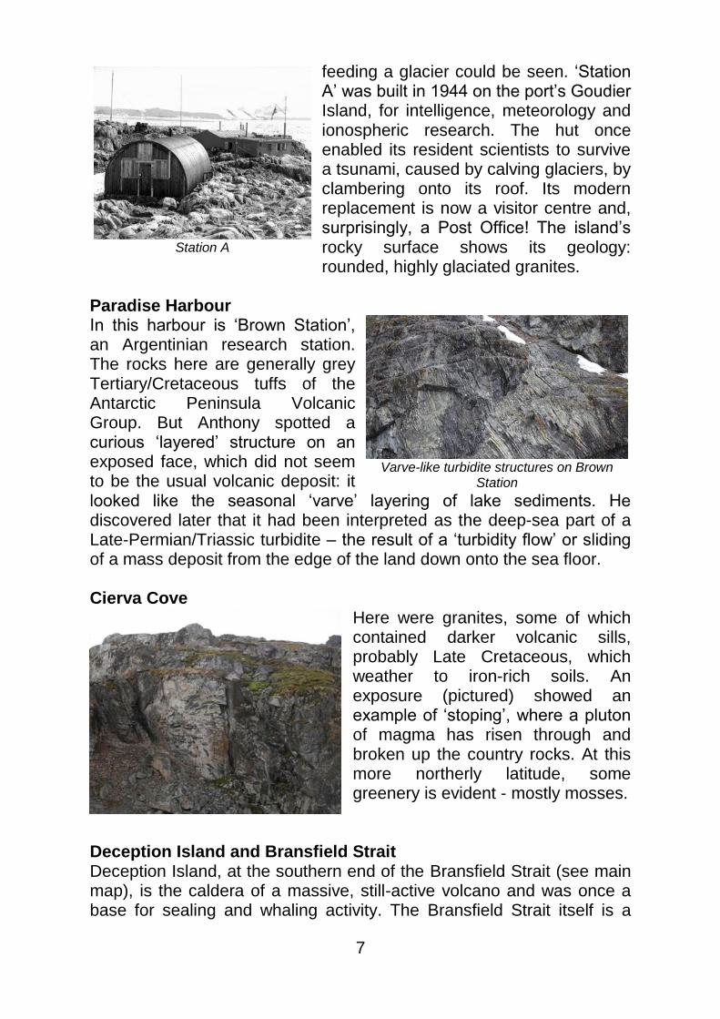
feeding a glacier could be seen. ‘Station A’ was built in 1944 on the port’s Goudier Island, for intelligence, meteorology and ionospheric research. The hut once enabled its resident scientists to survive a tsunami, caused by calving glaciers, by clambering onto its roof. Its modern replacement is now a visitor centre and, surprisingly, a Post Office! The island’s rocky surface shows its geology: rounded, highly glaciated granites.
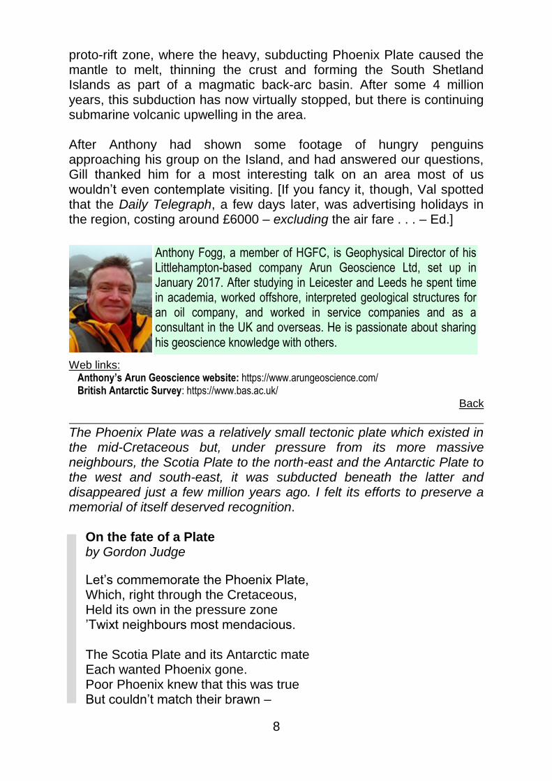
Paradise Harbour In this harbour is ‘Brown Station’, an Argentinian research station. The rocks here are generally grey Tertiary/Cretaceous tuffs of the Antarctic Peninsula Volcanic Group. But Anthony spotted a curious ‘layered’ structure on an exposed face, which did not seem to be the usual volcanic deposit: it looked like the seasonal ‘varve’ layering of lake sediments. He discovered later that it had been interpreted as the deep-sea part of a Late-Permian/Triassic turbidite – the result of a ‘turbidity flow’ or sliding of a mass deposit from the edge of the land down onto the sea floor. Cierva Cove
Here were granites, some of which contained darker volcanic sills, probably Late Cretaceous, which weather to iron-rich soils. An exposure (pictured) showed an example of ‘stoping’, where a pluton of magma has risen through and broken up the country rocks. At this more northerly latitude, some greenery is evident - mostly mosses.
Deception Island and Bransfield Strait Deception Island, at the southern end of the Bransfield Strait (see main map), is the caldera of a massive, still-active volcano and was once a base for sealing and whaling activity. The Bransfield Strait itself is a
Station A
Varve-like turbidite structures on Brown Station
8
proto-rift zone, where the heavy, subducting Phoenix Plate caused the mantle to melt, thinning the crust and forming the South Shetland Islands as part of a magmatic back-arc basin. After some 4 million years, this subduction has now virtually stopped, but there is continuing submarine volcanic upwelling in the area. After Anthony had shown some footage of hungry penguins approaching his group on the Island, and had answered our questions, Gill thanked him for a most interesting talk on an area most of us wouldn’t even contemplate visiting. [If you fancy it, though, Val spotted that the Daily Telegraph, a few days later, was advertising holidays in the region, costing around £6000 – excluding the air fare . . . – Ed.]
Web links:
Anthony’s Arun Geoscience website: https://www.arungeoscience.com/ British Antarctic Survey: https://www.bas.ac.uk/
Back
The Phoenix Plate was a relatively small tectonic plate which existed in the mid-Cretaceous but, under pressure from its more massive neighbours, the Scotia Plate to the north-east and the Antarctic Plate to the west and south-east, it was subducted beneath the latter and disappeared just a few million years ago. I felt its efforts to preserve a memorial of itself deserved recognition.
On the fate of a Plate by Gordon Judge
Let’s commemorate the Phoenix Plate, Which, right through the Cretaceous, Held its own in the pressure zone ’Twixt neighbours most mendacious. The Scotia Plate and its Antarctic mate Each wanted Phoenix gone. Poor Phoenix knew that this was true But couldn’t match their brawn –
Anthony Fogg, a member of HGFC, is Geophysical Director of his Littlehampton-based company Arun Geoscience Ltd, set up in January 2017. After studying in Leicester and Leeds he spent time in academia, worked offshore, interpreted geological structures for an oil company, and worked in service companies and as a consultant in the UK and overseas. He is passionate about sharing his geoscience knowledge with others.

9
Its south-east flank had already sank Beneath the cruel Antarctic. Though much aggrieved, it now conceived A really most bizarre trick: Its subducting crust, it reasoned, must Sink mantlewards so steep That a trench is created ’twixt it and the hated Antarctic – and it would be deep. And, what is more, the Antarctic’s shore Would be stretched until, onto the scene Hot magma bursts through, making islands anew With a back-arc-type basin between. So Phoenix has gone, but its memory lives on In the South Shetland Islands (and, too, The Bransfield Strait), recording the fate Of the Phoenix Plate, disappeared from view . . .
Back
SNIPPET: CORE TIME
Like most of us, Professor Richard Holme was wondering where all the time had gone. But he was at the University of Liverpool and had the advantage of 50 years of GPS and astronomical data to look for an answer. It seems there is a ‘well-known’ cyclic variation in day length which results from slow changes at the Earth’s core: days get a few milliseconds longer over ten years or so, then get shorter again. And there’s a 5.9-year cycle which changes day length by fractions of milliseconds a year. That one is because the fluid outer core wobbles relative to the surrounding mantle. But these didn’t quite explain the data, and when Richard looked at what was left, he discovered a third effect on day length. In 2003, 2004 and 2007 the Earth’s spin stuttered: on each occasion, day length changed by a fraction of a millisecond and remained thus for several months before returning to ‘normal’. He concluded that this might have been due to a patch of molten outer core temporarily sticking to the underside of the mantle, causing a step change in the Earth’s angular velocity. This could also be the cause of jerks, recorded by satellites over the last 20 years, in the planet’s magnetic field which he found coincided with the jumps in spin rate. (New Scientist, 10 July 2013)
Back

10
The Chalk cliffs and shore platforms of Sussex David Robinson Report by Gordon Judge
The Seven Sisters, David told us, are known the world over (though sometimes confused with the White Cliffs of Dover). Its dry valleys have been, and continue to be, truncated by coastal erosion. The rate at which the cliff face here is retreating varies, typically averaging between 30 and 40 cm/yr, whereas at Birling Gap it’s roughly double that; but cliff retreat occurs in steps, not continuously. The exposed near-vertical chalk cliff faces of East Sussex are under continuous attack from both sea and air: offshore waves, tides, stormy weather wetting and drying out the rock, frost freeze-thaw action and, (perhaps) most importantly, deeply-penetrating salt spray; and all these can vary with climate. David’s talk focussed on what might cause, and affect the rate of, cliff retreat. Aspect You’d think that the direction of onshore waves relative to the cliff face, and the degree to which the face might be protected from them would be important, but it seems that it ain’t necessarily so. For example, the chalk cliffs on the French side of the Channel, whose cliffs are not in the firing line of the prevailing winds, have generally higher rates of erosion.
Geology Chalk is variable in its characteristics, and therefore in its erosion resistance. The strong vertical jointing of the Seaford Chalk means that it tends to fail in ‘slices’, starting with a visible crack at the clifftop: the ‘slice’ does not topple over but instead
slides downwards – no undercutting by wave action at the base is required. The ‘slice’, typically 1–4 metres thick, more or less retains is original stratigraphy as it slides, which is why a soil layer is often seen at the top of a heap of fall debris. It’s thought that the flow of cliff fall
Cuckmere Haven and the Seven Sisters
Near-vertical face of the Seaford Chalk
11
debris out to sea is helped by a cushion of trapped air, or is lubricated by water – but it’s not known for sure. Fine grains are then swept out to sea, but coarser material remains on the platform for longer.
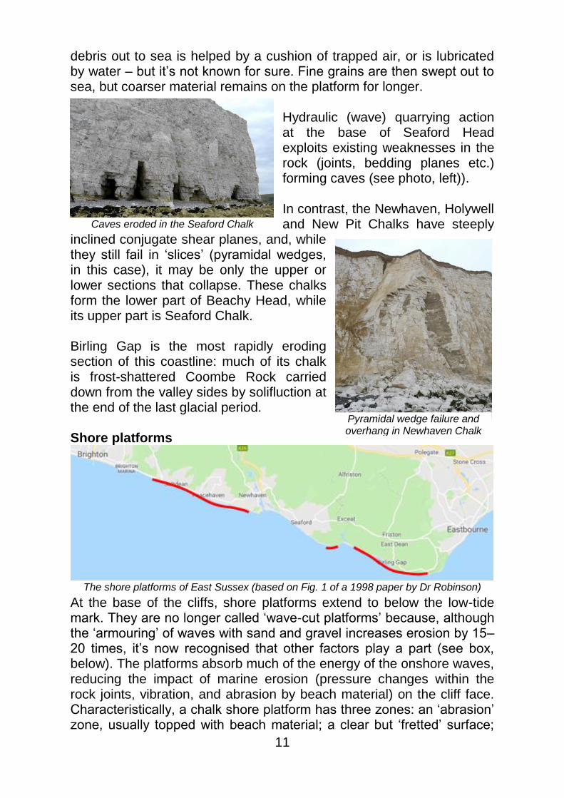
Hydraulic (wave) quarrying action at the base of Seaford Head exploits existing weaknesses in the rock (joints, bedding planes etc.) forming caves (see photo, left)). In contrast, the Newhaven, Holywell and New Pit Chalks have steeply
inclined conjugate shear planes, and, while they still fail in ‘slices’ (pyramidal wedges, in this case), it may be only the upper or lower sections that collapse. These chalks form the lower part of Beachy Head, while its upper part is Seaford Chalk. Birling Gap is the most rapidly eroding section of this coastline: much of its chalk is frost-shattered Coombe Rock carried down from the valley sides by solifluction at the end of the last glacial period. Shore platforms
At the base of the cliffs, shore platforms extend to below the low-tide mark. They are no longer called ‘wave-cut platforms’ because, although the ‘armouring’ of waves with sand and gravel increases erosion by 15–20 times, it’s now recognised that other factors play a part (see box, below). The platforms absorb much of the energy of the onshore waves, reducing the impact of marine erosion (pressure changes within the rock joints, vibration, and abrasion by beach material) on the cliff face. Characteristically, a chalk shore platform has three zones: an ‘abrasion’ zone, usually topped with beach material; a clear but ‘fretted’ surface;
The shore platforms of East Sussex (based on Fig. 1 of a 1998 paper by Dr Robinson)
Pyramidal wedge failure and overhang in Newhaven Chalk
Caves eroded in the Seaford Chalk

12
and a seaweed-covered area. Erosion tends to concentrate along down-slope runnels at intervals along the platform, where beach material is rolled by wave action, progressively enlarging them. Between Hope Gap and Cuckmere Haven, the bases of ‘solution pipes’ can be seen on the platform. Platform erosion is aggravated by biological activity: limpets graze on algae on the rock surface, and snail slime can dissolve the surface. And, while seawater is saturated in calcium carbonate, the fresh water that emerges from natural springs onto the platform or under gravel beaches can contribute to chemical weathering of the platform surface. Measurements of the rate of (vertical) erosion of Sussex shore platforms give a typical average rate of around 3½ mm/yr, but rates can be greater in years when very low temperatures coincide with very low tides, such as 1985–6, or less if there’s a flint layer.
Shore platforms slope seawards at between 1
and 4, often with ‘steps’, perhaps where flint bands or bedding planes occur, of up to about 0.5 metres. These also erode and retreat towards the cliffs. Recently, measurements using radioactive beryllium (10Be) on Sussex chalk platforms, have been used to estimate rates of cliff retreat. There are problems with the technique, concerning seaweed and the depth of sea, but 300–500 years ago (horizontal) retreat rates seem to have been much lower – between 2 and 6 cm/yr – than currently, or around a tenth of recent their present values. We know that Britain’s climate deteriorated around 500 years ago, during the ‘Little Ice Age’, so this could be because of stormier weather and thinning of the beach cover due to the installation of groynes in the 19th century. Confusingly, map measurements seem to show slower retreat rates than over the previous century.
How shore platforms evolve:
Arrows show actions; dashed arrows show
interactons.
[Based on Fig.2 in Dr Robinson’s 2002 paper]
Climate
Marine processes
(waves & tides)
sub-aerial weathering processes
biological organisms
& processes
the rocks’
characteristics
shape of the shore
platform
erosion of the shore
platform
shape of the cliff, and
processes making it
retreat

13
Beach material Shingly beach material on the platforms also helps to absorb wave energy; but if it’s only a thin layer it can be rolled to and fro, increasing erosion. However, the mobility of shingle means that any natural obstruction on the platform, such as a fallen block, reduces erosion behind it and increases erosion in front of it. Human impact Interference with movement of beach material by structures such as groynes (from the 1800s) and harbour walls can block removal of cliff-fall material. Geological historical inheritance When the Romans first saw the White Cliffs, they would have been 600–700 metres seaward of their present position (if current rates of retreat prevailed). Some 5000–6000 years ago, when sea level reached its present height after the last glacial period, the cliffs might have ended 1500–2000 metres out to sea from where they are now. The shore platforms could have been formed in the post-glacial period, and might then have been more extensive. Past interglacial sea levels were higher than now, so that ancient ‘raised beaches’ exist beneath the West Sussex coastal plain. One of these intersects the present coastline at Black Rock, Brighton, at about 70 m above mean sea level. The edge of this ‘raised beach’ can be traced inland, roughly following the line of Brighton’s Western Road. Mantell described it as extending, in places, eastwards as far as Rottingdean. The future Sea level is rising, reducing the effectiveness of the platforms in protecting the cliff faces. In addition, climate change predictions suggest that the climate will become stormier and extreme events will be greater, delivering more wave energy towards the cliffs. None of the South Coast’s beaches are self-sustaining in terms of their gravel cover: fresh flint fall from the cliff faces is nowhere near enough to sustain it, so the available gravel would have been largely driven onshore as the sea level rose following the last glacial period - our beach shingle is a ‘fossil resource’, which has to be periodically ‘recharged’. The most
The ‘fossil’ raised beach at Black Rock

14
likely future outcome is increased erosion, but the scale of this is not known – scope for further research! After David had skilfully fielded the inevitable questions, Beryl passed on our thanks for a lecture which, as she said, will enable us to see our familiar coast with new eyes. Ed’s footnote: Please pass on your knowledge so that people don’t do what these folk are doing! >> Web links
CoastView (Sussex University): http://www.sussex.ac.uk/geography/researchprojects/coastview/ Retreat of Chalk cliffs and downwearing of shore platforms (Dornbusch, 2001): Click here to
view this University of Sussex paper in pdf format Modelling platform dynamics (2002 paper by Dr Robinson):
www.sussex.ac.uk/geography/researchprojects/coastview/shoreplatform/dave.pdf 10Be study (Hurst, et al, 2016): https://www.ncbi.nlm.nih.gov/pmc/articles/PMC5127313/
Back
SNIPPET: HOW CLIMATE CHANGE AFFECTS YOUR COMPASS
The Earth is neither a perfect sphere nor solid. In particular, the stuff at or near its surface gets moved around by plate tectonics, by land rising as it recovers from ice cover, by erosion and by the weather. In turn, that makes the tilt of its polar axis change: for example, from 1982 to 2005, the North Pole moved southwards, averaging about 6 cm per year. But in 2005 it abruptly began drifting eastwards. Jianli Chen, of the University of Texas in Austin, spotted that this was also when the rate of melting on Greenland and Antarctica increased. From satellite gravity measurements he estimated how much ice was being shed as water from glaciers, and calculated the effect of the redistribution of its mass from these localised glacial regions into the oceans. He and his colleagues found that, through this effect, climate change could account for 90% of the post-2005 polar drift. (New Scientist, 25 May 2013
Back
David Robinson is Reader in Physical Geography at the University of Sussex’s School of Global Studies and is currently the University‘s Director of Academic Programmes. He has taught at the Universities of Zambia and Sierra Leone. He is a member of the Coastal and Estuarine Research Group at Sussex (CERAS). He is interested on the impacts of environmental and climatic change on weathering and erosion processes.

15
Bill Bryson and the stromatolites of Shark Bay Bill Bryson OBE HonFRS
This is an extract, reproduced with the author’s permission, from chapter 19 of Down Under, by Bill Bryson (Doubleday, 2000). He is near Hamelin Pool, on a boardwalk that leads visitors over the shallows and close to the stromatolites of Shark Bay on Australia’s western coast*. Stromatolites are not easy to describe. They are of so primitive a nature that they don’t even adopt regular shapes in the way, say, crystals do. Stromatolites just, as it were, blob out. Nearer the shore they formed large, slightly undulant platforms – rather like very old asphalt. Further out they were arrayed as individual clumps that brought to mind very large cow-pats, or perhaps the dung of a particularly troubled elephant. Most books refer to them as club-shaped or cauliflower-shaped or even columnar. In fact, they are shapeless grey-black blobs, without character or lustre. It has to be immediately conceded that a stromatolite formation is not a handsome or striking sight. I can almost guarantee that your reaction upon seeing a bed of living stromatolites for the first time will be to say ‘Hmm’ in the vague,
ruminative, cautiously favourable tone you would use if you were given a canapé that tasted better than it looked but not so good that you wanted another right away, or possibly ever. It is a sound that says, “Well, I’ll be.” So it’s not the sight of stromatolites that makes them exciting. It’s the idea of them – and in this respect they are Stromatolites near Hamelin Pool
Shark Bay
Hamelin Pool
stromatolites

16
peerless. Well, imagine it. You are looking at living rocks – quietly functioning replicas of the very first organic structures ever to appear on earth. You are experiencing the world as it was 3.5 billion years ago – more than three-quarters of the way back to the moment of terrestrial creation. Now if that is not an exciting thought, I don’t know what is. As the aforementioned palaeontologist Richard Fortey has put it: “This is truly time travelling, and if the world were attuned to its real wonders this sight would be as well-known as the pyramids of Giza.” Quite right. Stromatolites are rather like corals in that all of their life is on the surface, and that most of what you are looking at is the dead mass of earlier generations. If you peer, you can sometimes see tiny bubbles of oxygen rising in streams from the formations. This is the stromatolite’s only trick and it isn’t much, but it is what made life as we know it possible. The bubbles are produced by primitive algae-like organisms called cyanobacteria, which live on the surface of the rocks – about three billion of them to the square yard, to save you counting – each of them capturing a molecule of carbon dioxide and a tiny beat of energy from the sun and combining them to fuel its unimaginably modest ambitions to exist, to live. The by-product of this very simple process is the faintest puff of oxygen. But get enough stromatolites respiring away over a long enough period and you can change the world. For two billion years this is all the life there was on earth, but in that time the stromatolites raised the oxygen level in the atmosphere to 20 per cent – enough to allow the development of other, more complex life forms: me, for instance. My gratitude was real. The chemical process involved in this makes the little cells very slightly sticky. Tiny motes of dust and other sediments cling to their surfaces and these slowly bind and accrete into the rocks I was looking at now. The stromatolites thrive here not so much because they the conditions are particularly amenable to them as because they are discouraging to other creatures. The reason stromatolites don’t exist elsewhere is that they would either be washed away by stronger tides or eaten. Here nothing else can survive the bitter salt waters, so there is nothing to graze the stromatolites away. That stromatolites gave rise to life on earth, then became a food themselves and were eaten out of existence has a certain irony, of course. Something not entirely unlike that happened to me now, for as I stood studying the crystalline waters the elderly day trippers could be heard coming down the track, and a few minutes later the spryer among them began to arrive on the boardwalk. A woman in a Miami Dolphins eyeshade took a position beside me, stared at the water for some

17
moments, waved away a couple of flies, then regarded her husband and in a voice that would have drowned the clang of a steelworks said: “Are you telling me we just crossed a continent for this?” I was feeling charitably disposed, so I turned to her with an understanding smile and with all the gentleness and tact I could muster I endeavoured to ease her into a position of appreciation for this marvel that lay at our feet. I saluted her perceptiveness in recognizing that stromatolites were not much to behold, but explained how their diligent, infinitesimal chemical twitchings, over a span of unimaginable duration, made the world the green and lovely place it is. I pointed out too that at only two other places on earth have such living formations been found – one elsewhere in Australia, the other off a remote coral cay in the Bahamas, both much smaller and practically inaccessible – so that this was the only place in the world where visitors could with relative ease examine these singular creations in their full understated glory. So in fact, I concluded – and here I offered my warmest, most ingratiating smile – this really was worth crossing a continent for. She listened with what I can only call an air of startled submissiveness, never taking her gaze from my face. Then she touched a hand to my forearm and said: ‘Did you know that you have terrible sunburn?’ * Web hint:
Search for ‘Hamelin Pool’ on Google Earth, then move WNW away from Google’s marker towards the water and zoom in a bit to find the actual Hamelin Pool. Now zoom in some more and follow the track to the coast where, if you zoom in even closer a little to the west of Hamelin Pool Caravan Park/Campground, you’ll find the zig-zag lines of the boardwalk and the dark grey blobs of the stromatolites.
Back
SNIPPET: WHERE THE WATER IS
Someone has estimated that there are about 1386 million cubic kilometres of water on our planet: 97% is in the oceans, 2.1% in ice caps, 0.6% in underground aquifers, 0.02% in lakes and rivers, and just 0.001% in clouds and atmospheric vapour. [If anyone knows where the other 0.279% is, please let me know. Ed.]
From 50 ideas you really need to know: Earth, by Martin Redfern (Quercus 2012) Back
Bill Bryson
18
Green men, French food and Fossils: Brexit and the Bajocian Bob Chandler Report by Peter Webster
On reading the advertised title of Bob Chandler’s latest talk to the Club, it appeared to be an intriguing yet eclectic collection of disparate terms, randomly cobbled together. Could they be combined into a coherent lecture? Actually they could: Bob did indeed aggregate these ideas to give yet another entertaining and informative talk to the Club. (And the technology was fully functioning on this occasion!) In the parlance of the football pundit, this was ‘a game of two halves’. First he gave a light-hearted explanation of the reference to the ‘Green Men’ in the title, followed by a setting of the scene of his French fossil research. Then came a more detailed discussion of the Bajocian fossils, particularly ammonites, which have been the focus of some of his recent work. So, the ‘Green Man’ was revealed as the French owner of a quarry, one Jérôme Caillet, with a penchant for science fiction, who apparently dresses as the fictional character and anti-hero Fantômas, complete with a mask and green suit, whilst driving that most idiosyncratic car, an ancient Citroën DS.
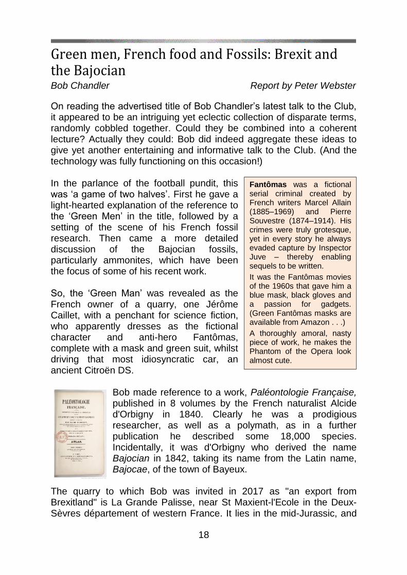
Bob made reference to a work, Paléontologie Française, published in 8 volumes by the French naturalist Alcide d'Orbigny in 1840. Clearly he was a prodigious researcher, as well as a polymath, as in a further publication he described some 18,000 species. Incidentally, it was d'Orbigny who derived the name Bajocian in 1842, taking its name from the Latin name, Bajocae, of the town of Bayeux.
The quarry to which Bob was invited in 2017 as "an export from Brexitland" is La Grande Palisse, near St Maxient-l'Ecole in the Deux-Sèvres département of western France. It lies in the mid-Jurassic, and
Fantômas was a fictional serial criminal created by French writers Marcel Allain (1885–1969) and Pierre Souvestre (1874–1914). His crimes were truly grotesque, yet in every story he always evaded capture by Inspector Juve – thereby enabling sequels to be written.
It was the Fantômas movies of the 1960s that gave him a blue mask, black gloves and a passion for gadgets. (Green Fantômas masks are available from Amazon . . .)
A thoroughly amoral, nasty piece of work, he makes the Phantom of the Opera look almost cute.

19
is closely related to the same horizons in Dorset, that is, the Bajocian. M. Caillet has encouraged research into the fossils found in the quarry. He is helped by a loose international group of palaeontologists calling themselves the ‘The Fantômas Brotherhood’. Each member has a particular interest such as brachiopods or ammonites. It is quite extraordinary that he has been able to collect so many eminent experts. As well as facilitating the detailed work taking place on the palaeontology of the section, the owner has preserved some of the industrial archaeology present on the site, such as the ancient lime-kilns. These are forming part of his museum, a learning resource, which he is developing on the site. He appears to have tapped into various funds by inviting local dignitaries and politicians to the site.
Having set the scene, Bob described some of the work taking place on the site. Images taken of the quarry face showed the meticulous care taken by real palaeontologists. Layers were carefully numbered and delineated, some only 10 cm deep, and the fossils were then extracted and prepared. Ammonites, Bob’s speciality, are an excellent subject of study, essentially when looking for subtle evolutionary and distribution patterns. Bob then showed a series of superb images representative of the ammonites which have been found at the site. He took care to elaborate on the significance of the suture lines. One facet of particular interest was the dimorphism between the sexes for a given species: the female, the macro-conch, being considerably larger than the male, the micro-conch. Returning to the lighter tone, he concluded his talk by showing images of a rather jolly group of his colleagues, imbibing red
Stratigraphic column of the quarry face
Lime kilns at Grande Palisse

20
wine. However, wine not only accompanied their evening meals, but à la mode française, at lunch-time also. As ever, our Club President has given us a most complete but also entertaining talk.
Club President Bob Chandler worked in the physiology labs of St Thomas’s Hospital before turning to teaching, becoming Head of Science at Shirley High School, gaining a OU degree in geology on the way. He is well known as an energetic specialist in Middle Jurassic ammonites and as a geological conservation enthusiast. He is consultant to Natural England on quarries in Dorset and Somerset, and on ammonites to the Natural History Museum. He is a Fellow of the Geological Society and in December 2018 was awarded a PhD for his work on the Middle Jurassic.
Back
John ‘Earthquake’ Milne (1850–1913) Gordon Judge
Born in Liverpool, John Milne studied at the Royal School of Mines, specialising in geology, and in 1875 became professor of geology and mining at Tokyo’s Imperial College of Engineering. Five years later, after the Yokohama earthquake, he set up the Seismological Society of Japan. Unlike others, Milne focused on producing an instrument that could record ground motion, and with time his colleagues acknowledged his views and led to the invention of the Milne-Gray seismograph. By the end of Milne's twenty-year period in Japan there were almost one
thousand centres where earth movements could be registered and recorded. Milne's work began to be recognised: in Britain, he was awarded the Lyell Medal by the Geological Society of London in 1894 and Fellowship of the Royal Society in 1887; and in Japan, the Order of the Rising Sun (third grade) in 1895. Milne became increasingly interested in earthquake mitigation. In the early 1880s he became involved in construction, designing innovative measures by which bridges and buildings might withstand earthquake shocks. The destructive Mino-Owari earthquake of 1891 led to the formation of the Imperial Earthquake Investigations Committee, of which
21
Milne was the only international member. He influenced the British Association for the Advancement of Science to set up a Seismological Investigation Committee in 1891 to investigate earthquake tremors that occurred in the British Isles. Over his time in Japan, his extensive field excursions led him to reject the belief and common theory that seismic activity was a direct result of volcanic activity. The Isle of Wight
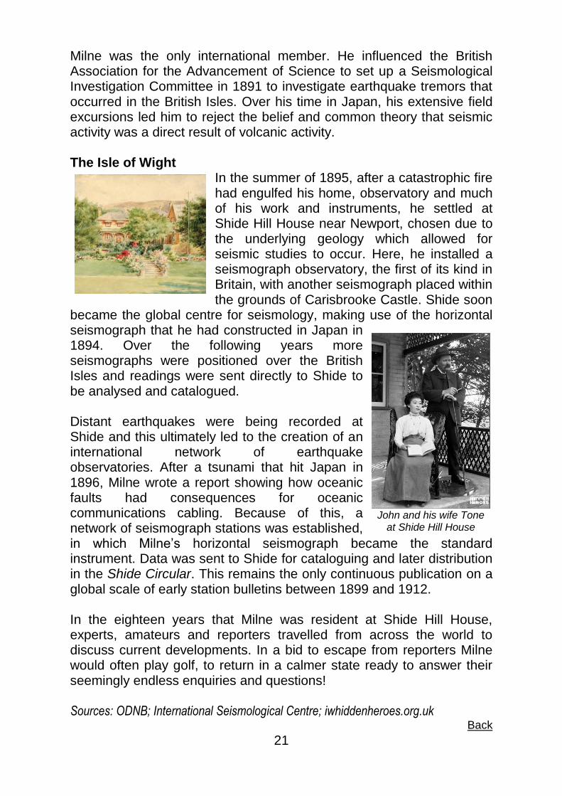
In the summer of 1895, after a catastrophic fire had engulfed his home, observatory and much of his work and instruments, he settled at Shide Hill House near Newport, chosen due to the underlying geology which allowed for seismic studies to occur. Here, he installed a seismograph observatory, the first of its kind in Britain, with another seismograph placed within the grounds of Carisbrooke Castle. Shide soon
became the global centre for seismology, making use of the horizontal seismograph that he had constructed in Japan in 1894. Over the following years more seismographs were positioned over the British Isles and readings were sent directly to Shide to be analysed and catalogued. Distant earthquakes were being recorded at Shide and this ultimately led to the creation of an international network of earthquake observatories. After a tsunami that hit Japan in 1896, Milne wrote a report showing how oceanic faults had consequences for oceanic communications cabling. Because of this, a network of seismograph stations was established, in which Milne’s horizontal seismograph became the standard instrument. Data was sent to Shide for cataloguing and later distribution in the Shide Circular. This remains the only continuous publication on a global scale of early station bulletins between 1899 and 1912. In the eighteen years that Milne was resident at Shide Hill House, experts, amateurs and reporters travelled from across the world to discuss current developments. In a bid to escape from reporters Milne would often play golf, to return in a calmer state ready to answer their seemingly endless enquiries and questions! Sources: ODNB; International Seismological Centre; iwhiddenheroes.org.uk
Back
John and his wife Tone at Shide Hill House

22
The Roots of the Hercynian mountains Mark Eller Report by Gordon Judge
Mark had led the field trip that Beryl reported on in some detail in last December’s Stonechat. His talk to the Club in April aimed to fill in the background to the way that SW England was affected by the formation of the Hercynian mountains some 370–290 million years ago – from the late Devonian, through the Carboniferous and into the early Permian.
To give a feel for the changes and the timespan, Mark showed an angular unconformity near Torbay, in Devon: its lower rocks are dipping, thin-bedded Lower Devonian marine mudstones, thin sandstones and tuffs, reddened during uplift and exposure during Permian
times, while the overlying rocks are red, Lower Permian, terrestrial alluvial fan conglomerates containing large clasts of locally-derived mid-Devonian limestones – a gap of about 100 million years, or the time from the Mid-Cretaceous to now. It was what happened in this gap that Mark’s talk would focus on. Plate-tectonic background In the Silurian, the mega-continents of Laurussia (Laurentia plus Baltica) and Gondwana were separated by the Rheic Ocean. During the Devonian, subduction brought them into collision, closing the Rheic Ocean from their western contact eastwards, causing back-arc extension, probably with an island arc (see Stonechat, June 2018,
p.13) and rifting. The rifting would have produced a series of half-grabens, initially creating the Looe Basin (see diagram left and box below), in which sediments accumulated. The rifting continued
Gondwana
Laurussia
Rheic Ocean
The Lizard ophiolite
Half-graben development by c.375 Ma (Upper Devonian)
Carb
on
ifero
us
Pe
rmia
n
Devo
nia
n
252 Ma
299 Ma
359 Ma
420 Ma

23
until, by the Early Carboniferous, it had extended northwards, adding the South Devon and Tavy Basins. Sedimentary sequences built up in the base of each trough: terrestrial mudstones at the base, then marine mudstones and shales, along with volcanic deposits that had risen to the surface along the faults; and on the crests were deposited reef-forming limestone sediments. From stromatoporoids to black shales At Daddyhole Cove, near Torquay, beds of the Torquay Limestone are dominated by stromatoporoids (see Stonechat, December 2018, p.25), together with tabulate and rugose corals. Much of this reef-forming community was wiped out during several mass extinctions around the end of the Devonian. By the Late Devonian, however, the colonisation of land by seed- and spore-bearing plants had begun, helped by their evolution of stiffer, lignin-based cell walls that could support taller and broader stems up to 100 cm diameter. Tall plants
need decent roots, and roots help to create soil by breaking up rock. That releases nutrients which get washed into the sea via rivers, and marine algae love nutrients! But algal blooms use up surface oxygen, starving deeper waters of the gas, temporarily killing off marine organisms and producing black shales on the sea floor. These are now the black Babbacombe Slates.
Brixham Limestone Berry Head, at the tip of the promontory at the southern end of Tor Bay, is part of the ‘English Riviera UNESCO Global Geopark’. The rocks are all recrystallized stromatoporoid reef limestones – the Brixham Limestone. In the huge quarry on its northern flank are several dramatic ‘Neptunian’ dykes of red sandstone filling cracks that had appeared when the limestones were exposed during the Permian. Fine-grained
Half-grabens
Half-grabens are structures formed when a series of normal faults dip in similar directions: each fault block tilts and slips down relative to the fault next to it.
Slates and extrusive dolerite sills at Half Tide Rock, Babbacombe

24
alluvial material was later washed into the cracks, and further cracking let in calcite veins – see photo below (the dyke is about 1 m wide). A metamorphic journey Recent re-mapping of the area shows a series of south-dipping thrusts and nappes, about 4 km apart. A coastal traverse from Saltern Cove, near Paignton, to Start Point begins with Late Devonian well-cleaved shales. By the time you reach Man Sands, the slates contain very deformed quartz veins: the minerals here have been recrystallised and re-oriented to create their slaty cleavage. Further south at Blackpool Sands are strongly foliated phyllites in which the slate has been further
metamorphosed so that its fine-grained mica content has become oriented in a common direction, in this case twice, in different directions – ‘crenulation cleavage’).
Crossing the Start Boundary Fault southwards to Lannacombe Bay takes you to an even higher grade of metamorphism: grey-green schists with the same chemistry as the rocks to the north, but a different mineralogy. Finally, at the very tip of Start Point are some light-green amphibolites, formed from basalt. This implies metamorphism at a
depth of about 30 km and a temperature of at least 600 C. The Normannian Nappe The geology of England’s southwest peninsula is ’banded’: each ‘band’ was originally a rift basin, as described above – the more northerly basins formed later than those further south. During the Upper Devonian, the southerly Gramscatho Basin began to be compressed as the Normannian Nappe, a sheet of very old crystalline
Berry Head quarry: Permian red sandstone ‘Neptunian’ dyke with
calcite veining
Sedimentary basins of Devon & Cornwall
Crenulation cleavage in slate

25
basement rocks, approached from the south and came to the surface, now exposed as an ophiolite (oceanic crust and underlying mantle material) obducted at the tip of the Lizard Peninsula. The Carboniferous Period: the Hercynian mountains
The Devonian sediments became covered by Carboniferous material. The basins of southwest England were greatly shortened by the gigantic compressive forces of the Variscan/Hercynian orogeny. At Hartland Quay, the degree of compression is evident from the extreme distortion of the original mudstones and fine sands – see photo (left).
By the Middle Carboniferous, further tectonic movements had resulted in the supercontinent of Pangaea. The Hercynian mountains, rising rapidly to the north and south of these basins, was transcontinental, and probably the largest ever to appear on our planet. Their erosion rate would have been huge; in particular, the Culm Basin collected much erosional material as sediments. Hercynian granites The blobs on the map on the previous page show the granite
exposures of the area, except for one: Haig Fras is a 45 km long underwater granite outcrop 95 km WNW of the Isles of Scilly. Gravity and radiometric measurements suggest that all these are the surface expressions of a single subterranean granite batholith which erupted at different times in the Permian, over about 30 Ma. Mark explained that these granites were
not the result of subduction; instead, they were formed as the weight of the colossal, rising Hercynian mountain chain bore down on the crustal
Hartland Quay
The Pangaea supercontinent, 340 Ma, showing the Hercynian mountain range
UK
Haig Fras (scanning sonar image)
26
rocks. The pressure was enough to melt the crust below, producing granitic fluids which fractionated differently as they rose at different times in different places. Their various mineralogies now appear in the surface granite outcrops. Evidence of volcanic activity associated with the melting can be found in rhyolitic clasts preserved in some of the Permian basins to the north. On the edge: valuable deposits At Burrator Quarries SSSI, near the south-eastern edge of Dartmoor, there are rare exposures of the contact between the Dartmoor granite and Devonian country rocks – if you know where to look! Just outside the granite intrusions are a number of disused tin mines, such as Bagtor. Tin, and other valuable deposits such as arsenic, tungsten, silver, gold and lead, are found in such places because they were ‘expelled’ from the granitic magma into cracks as it cooled. Oil was also formed from the ‘cooked’ Carboniferous mudstones and Devonian shales, and transported in the circulation of heated water through the granite, so that oil seeps are now common in the mines. Birch Tor is the only place actually on Dartmoor with tin mines, implying that this was once the edge of the granite intrusion. In places such as Two Bridges and Blackaton Cross, the hot circulating water degraded the granite, changing the feldspar to quartz sand and kaolin and destroying the rock’s cohesion. The kaolin is now extracted, using high-pressure hoses, for use in paper, ceramics, toothpaste, paint, rubber, sealants etc. Back to its roots So the ‘roots’ of the Hercynian mountains are there in the sedimentary basins of Devon & Cornwall. But “the New Red Sandstone of the Permo-Triassic,” said Mark, “is another 100-million-year story.” So we applauded the epic tale he had just related in such detail, and thanked him for telling it to us.
Web links:
Golonka, J & Gawęda, A (2012): Plate Tectonic Evolution of the Southern Margin of Laurussia in the Paleozoic: https://www.intechopen.com/books/tectonics-recent-advances/plate-tectonic-evolution-of-the-southern-margin-of-laurussia-in-the-paleozoic
Back
With degrees from Oxford and Reading, Dr Mark Eller worked for BP for 33 years as a sedimentologist, geologist, geophysicist and petrophysicist, often working closely with (oil) reservoir engineers After a career as a geologist in the oil industry, he is now “happily retired and organising Field Trips.” He is “Vice President, Field Trips and Fun” in the Mole Valley Geological Society.
27
AGM 2019 Gordon Judge
This was the Club’s 42nd AGM, with all the usual ingredients. Plus a dinosaur stomach-stone. This was our Secretary’s introduction to the joys of field-tripping in “unbelievable holes in the ground” such as Smokejacks, whose excavated cross-sections display millions of years of history. Here, for example, Baryonyx walkeri and assorted iguanodons were “stomping along” on the 130-million-years-ago layer; and when their stomping days were over they left fragments in the mud especially for Club members to find. Field trips also offer opportunities for plant-spotting and walking, enthused Gill – provided you’re appropriately attired (read the risk assessment on the Club website!) and let the organiser know in advance that you’re coming. The proceedings proper were opened by our Vice President, founder member Frank Diggon, who was pleased to see so many members present. Frank had organised our lecture programme for around 30 years. In contrast, Beryl has been doing it for “only” 11 years, but will now relinquish at least the speaker-liaison, speaker-ferrying and publicity parts of the rôle. No hands shot up at hearing this, but members might be sounded out about sharing in the work in this way. Gill’s Club Report touched on past problems with computer connections (now resolved), members’ participation in last year’s Fun Day in the Park, the Council for British Archaeology SE Regional Conference, the Sussex Mineral & Fossil Show and the successful field trip to Wales (organised by our Field Trip Secretary, Mike Webster), where trilobites were confirmed as “abundant” (at least, they were before our members appeared). Finally, there was praise for Stonechat and its contributors, and thanks to Club committee members. The Treasurer, Lecture Programme Coordinator and Field Trip Secretary did their things, and proposers and seconders were found to approve them. The Committee, now reduced to just 5 people by the standing-down of Frank and Val, was re-elected. And despite having a nightmarish time checking the Treasurer’s submission of this year’s accounts, Gillian Toye agreed to do it all over again next year. After a short refreshment break, members were subjected to a couple of vaguely philosophical poems from your Editor, and a truly brain-straining quiz from Gill.
Back

28
Club Programme 2019
Wed. Jun. 12 The last British ice sheet. Dr Bethan Davies, Royal
Holloway, University of London
Sun. Jul 7 Funday Sunday: HGFC stand at in Horsham Park
Wed. Jul. 10 After the Chalk, the Palaeogene: rocks and fossils of West Sussex. David Bone FGS
August No meeting
Sun. Jul. 14 Geological walk (with West Sussex Geological Society) in the Ashdown Forest – see website for details
Sat. July 20 Summer barbecue at Beryl’s – 2.30 pm: see website for details
Wed. Sep. 11 Darwin as geologist. Dr Chris Duffin, Natural History Museum
Wed. Oct. 9 Offshore Wind Farms as Renewable Energy. David Shilston, Technical Director for Engineering at Atkins (an international management consultancy)
Wed. Nov. 13 Detecting and monitoring geohazards from space, or, A Welsh collie, an earthquake and a mad Irishman - Dr Renalt Capes, Earth Metrics
Sat. Nov 30 Christmas Party at Sue Reece’s house – 7.30 pm
If the diameter of the model [Earth] is reduced to a foot, features which form the grandest scenery or basins forming the largest oceans may be represented by the almost imperceptible puckerings and depressions
produced on a film of varnish which had dried upon its surface.
John Milne (Seismology, 1898)
Back
Club meetings Unless otherwise stated, all evening meetings are held at Forest Community School, Comptons Lane, Horsham at 7 for 7.30pm. To ease the Treasurer’s mind, we ask for a nominal contribution of 20p for coffee and biscuits. Field trips Field trips require appropriate clothing: waterproofs, stout boots or Wellingtons. All geological sites are potentially dangerous and members are reminded that they attend field trips at their own risk. Any children attending are the sole responsibility of parents or guardians. It is always advisable to telephone a Committee member, if you are coming on a field trip, in case there are any last-minute changes. Equipment for Field Trips Some UK sources of tools, clothing and other equipment for field trippers are: UK Geological Equipment (Freephone 0800 0336 062) Order online at http://www.ukge.com Geo Supplies Ltd (0114 245 5746) Order online at http://www.geosupplies.co.uk Geology Superstore (0800 977 8539) Order online at http://www.geologysuperstore.com Geological Maps and Area Guides: British Geological Survey (0115 936 3241) Order online at http://www.bgs.ac.uk/catalogue/home.html Geologists' Association (020 7434 9298) Order online at https://geologistsassociation.org.uk/shop/ Free tide Predictions: Tides4fishing (auto-corrects for BST) For any date (select date on calendar, and select place using map): http://www.tides4fishing.com/uk/england UK Hydrographic Office (manual correction needed for BST) For six days ahead: http://easytide.ukho.gov.uk/easytide/EasyTide/index.aspx
Edited by Gordon Judge
[Credits: Imperial War Museums (cover picture); Google Maps (Graham Land map); Wikipedia/Clamosa (Gondwana map); Researchgate/Haase (tectonic map); Anthony Fogg, with permission (granites, turbidite structures, stoping in Cierva Cove); British Antarctic Survey (Station A); Wikipedia (Cuckmere Haven); Dr David Robinson, with permission (Seaford Chalk, caves in Seaford Chalk, Black Rock raised beach); Peter Anderton, with permission: (wedge failure in Newhaven Chalk); Daily Mail/Patrick Goff (people sitting on edge of cliff); Google Maps (Australia); Google Earth (satellite view of Hamelin Pool area; Government of Western Australia (stromatolites in Shark Bay); Bournemouth Daily Echo (Bill Bryson); isc.ac.uk (John Milne photo); Carisbrooke Castle Museum (Shide Hill House); iwhiddenheroes.org.uk (John & Tone at Shide Hill House; bibliographique Paléontologie français (cover of Paléontologie Française, vol.1); www.chaux-labasse.com/geologie.html (stratigraphic column & lime kilns); Mark Eller, with permission (Waterside Bay); 2012/intechopen.com (Laurussia. Gondwana & Rheic Ocean); University of Sydney (half-graben diagrams); OUGS (Half Tide Rock, Berry Head quarry); alexstrekeisen.it (crenulation cleavage); le Boutillier/researchgate.net (sedimentary basins map); americanexpeditioners.com (Hartland Quay); http://dinosaurpictures.org (Pangaea); jncc/defra.gov.uk (Haig Fras)]
``
``` `