journal of - national speleological society · 2015-01-29 · journal of caves and karst studies,...
TRANSCRIPT
JOURNAL OFCAVE AND KARSTSTUDIES
April 1996Volume 58 Number 1ISSN 0146-9517
TheNationalSpeleologicalSocietyBulletin
Geology of a Large, High-Relief, Sub-TropicalCave System: sistema Purificación, Tamaulipas,Mexico
Hydrology of a Large, High-Relief Sub-TropicalCave System: sistema Purficación, Tamaulipas,Mexico
Pleistocene Cave Fauna from Peninsular India
Extremely Low Frequency Radio Emissions in Bat Caves
Cave Pseudosinella and Oncopodura,New to Science
THIS ISSUE:

EditorLouise D. HoseP.O. Box 3388
Littleton, CO 80161-3388(303) 771-3209
Production EditorJames A. Pisarowicz
Mesa State College - Montrose Center2233 E. Main
Montrose, CO 81401(970) 249-7573
BOARD OF EDITORSEarth Sciences-Bulletin Index
Ira D. SasowskyDepartment of Geology
University of AkronAkron, OH 44325-4101
ConservationGeorge Huppert
Department of GeographyUniversity of Wisconsin, LaCrosse
LaCrosse, WI 54601
Life SciencesVacant
Social SciencesMarion O. Smith
P.O. Box 8276University of Tennessee Station
Knoxville, TN 37916
AnthropologyPatty Jo Watson
Department of AnthropologyWashington UniversitySt. Louis, MO 63130
ExplorationVacant
Book ReviewsBetty Wheeler
1830 Green Bay StreetLaCrosse, WI 54601
Contributing EditorNorma Peacock - Abstracts
JOURNAL ADVISORY BOARDRane Curl Andy FlurkeyJohn Ganter Albert KrauseKathy Lavoie Tom MillerJohn Mylroie Tom Strong
Will White
Journal of Caves and Karst StudiesVolume 58 Number 1 April 1996
CONTENTS
EditorialLouise D. Hose 3
Opinion
The Role of Cave Exploration in Karst ResearchArthur N. Palmer 4
Articles
Geology of a Large, High-Relief, Sub-Tropical Cave System:sistema Purificación, Tamaulipas, Mexico
Louise D. Hose 6
Hydrology of a Large, High-Relief, Sub-Tropical Cave System:sistema Purificación, Tamaulipas, Mexico
Louise D. Hose 22
Pleistocene Cave Fauna From Peninsular IndiaK.N. Prasad 30
Extremely Low Frequency Radio Emissions in Bat CavesWalton C. Koemel 35
Cave Pseudosinella and Onocopodura: New to ScienceKenneth Christiansen and Peter Bellinger 38
Discussion
What are “Anthodites”? - ContinuedDonald G. Davis 54
What are Anthodites?: ReplyWilliam B. White 55
Bulgarian Archaeoastronomy Site or Bulgarian Quarry Site?Robert K. Mark and Bruce W. Rogers 56
Cave Science News 59
Authors 61
Long and Deep Caves of the World 62
The Journal of Caves and Karst Studies, formerly The NSS Bulletin, (ISSN 0146-9517) is published three times a yearby the National Speleological Society, 2813 Cave Avenue, Huntsville, Alabama 35810-4431. The annual subscriptionfee, worldwide, by surface mail, is $18 US. Airmail delivery outside the United States of both the NSS News and theJournal of Caves and Karst Studies is available for an additonal fee of $40 (total $55); The Journal of Caves and KarstStudies is not available alone by airmail. POSTMASTER: send address changes to the Journal of Caves and KarstStudies, 2813 Cave Avenue, Huntsville, Alabama 35810-4431.
Copyright © 1996 by the National Speleological Society, Inc. Printed by American Web, 4040 Dahlia Street, Denver,Colorado 80216
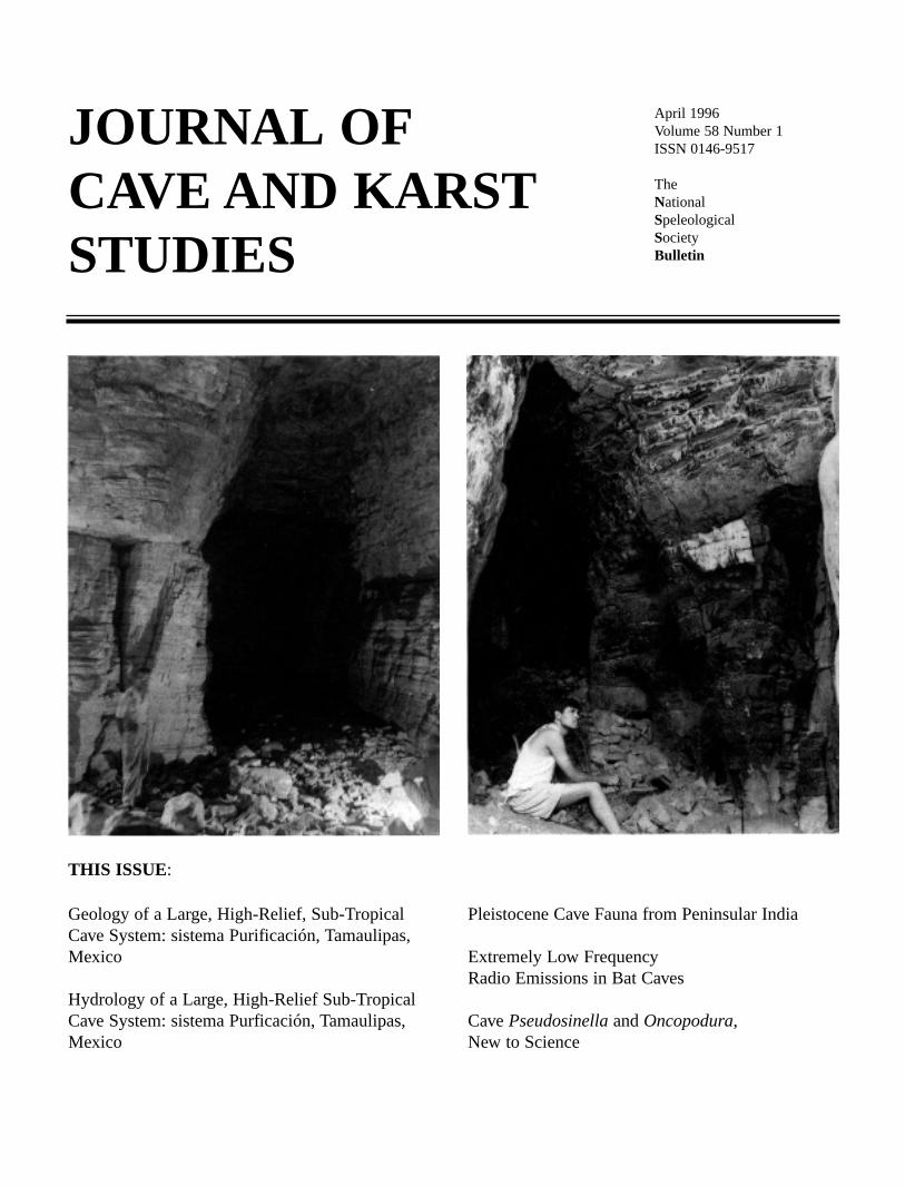
Cover: Yerrazari Gavi (left) and Sanyasula Gavi (right). See Prasad, page 30.

Journal of Caves and Karst Studies, April 1996 • 3
A NEW BEGINNING:EDITOR’S COMMENTS
The National Speleological Society has demonstrated itsdedication to the thorough exploration and study of caves bypublished refereed documentation of our activities in karstresearch in the NSS Bulletin for over 30 years. Throughout theyears, leaders of the Society worried that the Bulletin was tooesoteric to best serve the dues spent by most of our members.But, whenever the question was placed before the membership,you have strongly expressed your satisfaction and pride in ourscientific journal. Many scientists in our Society cite theBulletin as their main inspiration in pursuing professionalcareers in karst research.
NSS members have been great supporters of the scientificcommunity within the Society and now we hope to expand theBulletin to make it more interesting and valuable to all of ourmembers. After a year of discussions, an editorial in the NSSNews, and many letters from members, the NSS Board ofGovernors moved to make dramatic changes in our scientificpublication. With the current volume, you can expect to seethe following changes:
The name of the publication will change from The NSSBulletin: Journal of Caves and Karst Studies to Journalof Cave and Karst Studies: The National SpeleologicalSociety Bulletin.
There will be three issues (formerly only two issues) per yearwhich will typically be two regular issues and one themeissue.
Duties of the present editor will be split amongst two people inthe future. The “Editor” will be responsible for control-ling the refereeing process and general content of the pub-lication. The “Production Editor” will be responsible fortypesetting, proof-reading, and dealing with the printerand mailing.
Advertising for science-related products and publications willbe solicited.
While the majority of the Journal will contain refereed articlessimilar to the previous content of the Bulletin, separatesections will include editorials, conference announce-ments, conference reports, news briefs, and the abstractsfrom the annual convention.
Brief biographies and photos of the primary author of publica-tions will be included with each issue.
This issue also marks another transition. Andy Flurkeytook over the editorship of the NSS Bulletin in 1987 and hasserved with distinction for nine years. At the time of hisappointment, the Bulletin was over a year behind in its publi-cation schedule. Andy has steadily and successfully worked tomake the Bulletin both on time and a valued product. The dra-matic changes we plan today are only possible because of thestrong foundation Andy has built for the Bulletin during histenure. The Society owes Dr. Flurkey a great debt of gratitude
James A. Pisarowicz, Louise D. Hose, and AndrewFlurkey—left to right.
EDITOR - LOUISE D. HOSE, PH.D.
Louise D. Hose of Littleton, Colorado has been appointedEditor of the Journal of Cave and Karst Studies pending NSSBoard of Governors approval in March. Hose recently retiredafter five years as editor of Geo2, the NSS Cave Geology andGeography Section tri-annual newsletter and as associate edi-tor for exploration for the NSS Bulletin. She has a Ph.D. ingeology and taught at the University of Colorado, ColoradoSprings during the past seven years.
Hose is an active caver with an impressive record of explo-ration in Mexico, the western US, and elsewhere. Two articlesby her on the Purificación system in northern Mexico, whichpassed through the refereeing process before her appointment,appear in this issue.
PRODUCTION EDITOR - JAMES A. PISAROWICZ, PH.D.
James A. Pisarowicz of Montrose, Colorado was appointedProduction Editor of the Journal of Cave and Karst Studiespending NSS Board of Governors approval in March.Pisarowicz is the former Executive Director of the DeathValley Natural History Association and was the publisher of 16books. He was the Guest Editor for a Special Topics issue ofthe NSS Bulletin on the Black Hills. Pisarowicz has a Ph.D.in psychology and currently teaches psychology for MesaState College.
Pisarowicz has been honored with the Lew Bicking Awardfor his outstanding exploration efforts in Mexico, Papua NewGuinea, Mystery Cave in Minnesota, and Wind Cave, SouthDakota.
as he has chosen to retire after his many years of outstandingservice.
Fred Wefer, the NSS Executive Vice President, asked me toserve as the Interim Editor for the first issue of the newJournal. I will continue as editor after this issue if the NSS-BOG chooses to confirm my appointment in March. Weferalso asked Dr. James A. Pisarowicz to act as the ProductionEditor. He also will continue if the position is confirmed bythe board.
Louise D. Hose, Interim Editor

4 • Journal of Caves and Karst Studies, April 1996
THE ROLE OF CAVE EXPLORATION IN KARST RESEARCHARTHUR N. PALMER
Department of Earth Sciences, State University of New York, Oneonta, New York 13820-4015
In the early years of mountaineering, it was customary forexpedition members to haul up a variety of scientific instru-ments to give the impression that the climb was really just away of pursuing serious research. Some climbers were indeedscientists with a bona fide interest in the data, but in manycases the science was simply a smokescreen to deflect anyargument that exploration by itself was not a worthy endeavor.Of course none of the measurements amounted to much, butthe feats of exploration stand today as major triumphs.
Today, in a similar way,many karst researchersdownplay the importance ofcave exploration in theirwork. They slice away anyhint of sport from scientificpapers, as though cavesserve merely as gathering-grounds for scientific dataand are not of interest bythemselves. There are sever-al good reasons to do so.First, there is a scientificpecking order in which theo-retical and quantitative top-ics are considered more loftythan applied and qualitativestudies. Those who aspire tothe higher echelons must notsoil their hands with fieldwork (or so the currentthinking would have it).Besides, the average scien-tist looks at cave studiesmerely as glorified spelunk-ing. Why should karstresearchers hobble theirwork with unnecessary ref-erences to muddy crawl-ways?
There is a second andmore important reason toavoid describing caves in theprofessional literature—conservation. When writing for non-karst journals, I and many of my colleagues avoid unnecessaryreferences to cave studies that involve sampling, to avoid send-ing the message that collecting in caves is justified, even forscientific purposes. A genuine speleologist cares more about
the cave than about his or her research and will collect sampleswith caution and integrity, and only if no damage is done. Canwe guarantee that the next person will be so conscientious?Even a small number of “outside” samplers can cause havoc,and have done so in some instances. This is not a case of want-ing the entire playing field for ourselves. Unless a researcherhas a comprehensive view of how caves relate to their geolog-ic setting—which can be gained only by a lengthy study of thecaves and their surrounding karst—the results are worthless.
However, among our-selves, we must recognizethe importance of caveexploration. Without it, thevarious karst sciences wouldstill be in the dark ages.Many scientists made thefirst steps toward theircareers as cave explorers.Let’s not abandon our roots.Karst researchers who dis-parage exploration have lostan important part of theirheritage.
There is a growing ten-dency, particularly in thegeosciences, to minimizefield work. Industry andconsulting firms realize thattime is money, and there isno more time-consumingprocess than field work. As aresult, employees are askedto solve problems with com-puter models, remote sens-ing, and legal maneuversrather than by direct fieldobservation. The quality oftheir work suffers enormous-ly. This problem is mostserious among traditionalgroundwater hydrologists,most of whom know
appallingly little about karst, as a glance through any moderntextbook on groundwater will show. One groundwater hydrol-ogist acquired an international reputation as a karst specialistwithout ever visiting a cave! Needless to say, few of his con-tributions have stood the test of time. Caves control the devel-
Palmer, A.N.—The Role of Cave Exploration in Karst Research. Journal of Caves and Karst Studies 58(1):4-5.

Journal of Caves and Karst Studies, April 1996 • 5
opment of a karst landscape, and without their service asunderground drains, most surface karst features could notexist. A personal knowledge of cave patterns and their hydro-logic function is essential to the full understanding of karst.And only by mapping and exploring (or working closely withexplorers) can one appreciate the full significance of a cave’slayout. Exploration of caves beyond their normally accessiblelimits has yielded some of the most scientifically importantdiscoveries, such as Jewel, Lechuguilla, and Movile Caves. Asa result, cave science is no longer restricted to improved trailsin show caves. Microbiologists and geochemists are now buy-ing wetsuits and honing their vertical skills in order to visitimportant field sites in caves.
But cave exploration and mapping are not real science, arethey? Let’s take a closer look. As we explore a cave, we mustreview the basic ideas of how the cave is put together. Thisdoes not always bear fruit, and on the other hand there aremany examples of blind luck. But the process of thinkingabout where the cave might go — whether or not it actuallycooperates —is one of the most fundamental kinds of scientif-ic inquiry! It requires a synthesis and an understanding of whatis already known, and a projection of that information intounknown territory. This requires fundamental ideas about howa cave forms. New discoveries demand new ideas to explainthem. Such hypotheses are tested in the field, often at greatlabor. The success or failure of the explorer-researcher cannotbe exaggerated or hidden by technical jargon. During my the-sis field work in Indiana, I spent a great deal of time with localcave explorers who were still in high school. It was a memo-rable experience to hear them debate among themselves thedevelopmental history of the caves they were exploring.Without realizing it, they were spontaneously turning into sci-entists. This is fairly simple science, to be sure; but can anyonedeny that it lies at the heart of the scientific method?
Most scientists dwell at the cutting edge, where the actionis. Unfortunately, public support for science has withered inrecent decades, despite widespread alarm about diminishingstandards in our schools, because the link between science andthe common welfare is no longer clear. Ironically, the need fordecisions based on scientifically sound reasoning has neverbeen greater. The bridge between science and the public mustbe repaired, and the easiest way is to communicate the thrillthat was so apparent in those Indiana teenagers.
One of the greatest problems in selling karst to the outsideworld is the remarkably poor public understanding of whatcaves are really like. There is plenty of cave information avail-able, but most people cannot find it when it is needed. In anideal world, those faced with a karst problem would simplyturn to Speleologists in the Yellow Pages. Instead they try tosolve the problem themselves simply because they are unawarethat such talent even exists. Will they know enough to reach forthe Journal of Caves and Karst Studies? That is unlikely. Butif the Journal encourages even a few more explorers to takethat extra step in the direction of science, there will be thatmany more voices of authority speaking up when decisionsmust be made about land use and environmental problems inkarst.
I recommend the following. Give the Journal a greaterfocus on the basic description of caves and their setting.Imagine the value of articles that describe the basic layout,physical setting, and biology of the major caves of the US,written in language accessible to all readers. Aspects of caveexploration can be included if their link with science is clear,or if they provide significant historical perspective. In the samespirit, the dynamic aspects of science should be emphasized byopening the Journal to another kind of exploration — of con-troversial ideas, including debates of alternative viewpoints.This would require loosening the present format, but if suchcontributions are written authoritatively and submitted to peerreview, they will actually increase the scientific value of theJournal. We can afford to do this, because the primary goal ofthe Journal is to benefit our own members. We may wish it tobe widely recognized for its scientific content, but it is a spe-cialized publication of limited circulation that can never attainthe status of a mainstream professional journal. Instead, let itdo what it is best equipped to do: bring science to the non-sci-entific public. Our members can help achieve this goal by con-tributing articles designed to appeal to a wide range or readers.The Journal will grow stronger as a result, and so will the linkbetween cave exploration and research.
PALMER

6 • Journal of Caves and Karst Studies, April 1996
GEOLOGY OF A LARGE, HIGH-RELIEF,SUB-TROPICAL CAVE SYSTEM:
SISTEMA PURIFICACION, TAMAULIPAS, MEXICOLOUISE D. HOSE
Department of Geology, University of Colorado at Colorado Springs, Colorado Springs, CO 80933-7150
The objective of this study was to determine the geologiccontrols on development of the Sistema Purificación, thelongest known cave system in Mexico (Sprouse, 1992). Totalsurveyed length is 79.1 km, which places Sistema Purificaciónas the 6th longest known cave system in the WesternHemisphere and the 13th longest in the world (Gulden, 1992).The cave system has been described in numerous articles con-cerning the original exploration (Sprouse, 1977a, 1977b;Sprouse, Ubico, & Cavanaugh, 1977; Treacy, 1979, 1980) andin the annual journal, Death Coral Caver, which covers caveexploration activities in the area and is published by ProyectoEspeleológico Purificación. Sixty-seven other caves have beenexplored within the area of this investigation.
Sistema Purificación is developed in a thick carbonate sec-tion within the front range of the Sierra Madre Oriental. Therugged area, approximately 50 km northwest of CiudadVictoria (Fig. 1), rises two kilometers above the coastal plain.Presently, the total mapped depth of 955 m makes this cave theseventh most vertically developed system in the WesternHemisphere.
STRATIGRAPHY
INTRODUCTION
The total stratigraphic section of the study area is approxi-mately 800 m of marine sedimentary rocks, mostly carbonates.
Figure 1. Location map of the Purificación Area.
Shaly limestone, shale, sandstone, and conglomerate make upthe oldest unit, the Upper Jurassic La Joya Formation. TheUpper Jurassic La Caja and the Lower Cretaceous Taraises andTamaulipas, consisting of basinal limestone and shale, overliethe Ja Joya. The youngest rocks are overbank deposits of the
Hose, Louise D.—Geology of a Large, High-Relief, Sub-Tropical Cave System: Sistema Purificación, Tamaulipas, Mexico. Journal of Caves and Karst Studies 58(1):6-21.
Sistema Purificación, a large cave system in the northern Sierra Madre Oriental of México, is developedin the middle Cretaceous Tamaulipas and overlying Tamabra Formations. The 400 m thick sequence ofcarbonates formed in a basinal to peri-platform environment north and northeast of the simultaneouslydeveloping, large carbonate Miquihuana Platform. The Tamaulipas Formation is stratigraphicallyunderlain by shaly limestone, shale, sandstone, and conglomerate of the Early Cretaceous Taraises, theLate Jurassic La Caja, and the Late Jurassic La Joya Formations.
The cave system is within the west flank of the Huizachal-Peregrina anticlinorium, one of many largeLaramide folds making up the Sierra Madre Oriental. Most of the lateral shortening within the carbon-ates was accommodated by slippage along décollement surfaces and abundant second-, third-, andfourth-order folds. Except along décollement surfaces, faults are rare and have separations of less thanthree meters. Steeply inclined joints mostly trend ~N5°W and represent axial plane cleavage resultingfrom Laramide folding.
The principal geologic factors controlling the development of the Sistema Purificación are the stratigra-phy and structure of the area. Passages in the upper and lower cave commonly form along the intersec-tion of joints and bedding planes, sub-parallel to the dip. The middle part of the cave is within a third-order, anticlinal-synclinal pair whose north-south trending axial surfaces are about 150 m apart.Passages are mostly developed sub-parallel to the axial surfaces where cleavage provides zones of per-meability and enhanced conduit development.
Copyright © 1996 by the National Speleological Society

Journal of Caves and Karst Studies, April 1996 • 7
Figure 2. Generalized lithologic section and age boundaries near Conrado Castillo, Tamaulipas, México. Fossil identifi-cations and stage divisions are based on work by Atkinson (1982).
HOSE

8 • Journal of Caves and Karst Studies, April 1996
middle Cretaceous Tamabra Formation (Fig. 2).The Otates Formation, described by Enos (1974) and
Carrillo-Bravo (1961) as a well-defined, widespread, easilymappable stratigraphic marker within the Tamaulipassequence, is absent. The entire calcareous section between theTaraises and Tamabra Formations is considered in this paper tobe the Tamaulipas Formation.
LA JOYA FORMATION
The oldest exposed unit in the area, the Upper Jurassic LaJoya Formation, is a calcareous, clastic unit composed ofshale, shaly limestone, sandstone, and conglomerate. It typi-cally forms steep but not precipitous slopes, with some lowcliffs. The red to purple conglomerate, sandstone, and siltstonebeds contain siltstone, igneous, and metamorphic clasts. Graylimestone beds are argillaceous calcilutite and micrite.
The La Joya unconformably overlies Late Triassic toMiddle Jurassic, Paleozoic, and Precambrian rocks. Thesequence thickness varies and is locally absent. It probablyonly filled in depressions in the pre-Late Jurassic landscape.Deposition stopped early in the Oxfordian (Carrillo-Bravo,1961).
OLVIDO AND ZULOAGA FORMATIONS
Upper Jurassic carbonate and evaporite deposits of theOlvido and Zuloaga Formations overlie the La Joya Formationin some canyons to the east and southeast (Mixon, Murray, &Diaz, 1959; Carrillo-Bravo, 1961) but do not crop out withinthe study area.
LA CAJA FORMATION
The 70 m thick, Upper Jurassic La Caja Formation consistsof calcareous shale and shaly limestone. Beds are 10 to 50 cmthick with ubiquitous, poorly developed stylolites. Althoughthe unit is similar to the age-equivalent La Casita Formation asdescribed by Carrillo-Bravo (1961) in Cañones Esperanza,Rosario, and Olmo, it is called the La Caja Formation in thisreport because of its low clastic content, low-energy deposi-tional characteristics, and basin facies fossils (Imlay, 1943).Tan to steel-gray micrites are commonly altered to pink or yel-low. Vugs and fractures, largely filled by sparry calcite, arecommon. Pyrite grains and small, sparse nodules of chert arethroughout the section. Iron from weathered pyrite probablycauses the pink and yellow color of the altered rock. The cal-cium-magnesium ratio of 23:1 in one sample represents thepresence of some dolomite (Table 1). Ferrous carbonate insolid solution with the dolomite is another potential source ofiron. Approximately 17% of the sample was insoluble inhydrochloric acid and consisted of quartz, pyrite, chert frag-ments, and clay.
A broken topography of steep slopes and cliffs is formedby the alternating calcareous shale and limestone. Shale bedsform slopes that are commonly covered by soil. A 20 cm thickbed of fissile, non-calcareous (probably bentonitic) shale is
about six meters above the base of the unit. In the upper halfof the formation, wavy to nodular bedding is moderately well-developed. Shale and stylolites are less common, and beddingis more clearly defined within five meters of the gradationalupper contact with the Taraises Formation. The top of thehighest wavy bed marks the top of the La Caja.
TARAISES AND TAMAULIPAS FORMATIONS
The Neocomian-Aptian Stage limestone (Gamper, 1977)between the La Caja and Tamabra Formations is discussed asone unit in this report. The Otates is not present and theTaraises and lower Tamaulipas Formations are mostly indistin-guishable in the field. The 380 m thick Tamaulipas andTaraises Formations comprise limestone and minor quantitiesof shale that represent a long, uninterrupted period of quiet,basinal deposition. The limestone is predominantly a micritewith some calcilutite in the upper Tamaulipas. Microfossilsare abundant and compose as much as 90% of the volume.Upper beds contain large fossils and fossil fragments.
Some beds in the lowest 50 m of the section are mostlyblack shale. They are best exposed and thickest on the roadbetween the villages of Galindo and Conrado Castillo (Fig. 3).Laminated black shale and siltstone beds with a total thicknessof eight meters also form a slope southeast of Galindo. Fossilsare abundant, including bivalves and possible fish scales, butthere is no bioturbation. This is apparently the TaraisesFormation.
The shale interfingers with a sequence of alternating blackshale and nearly pure limestone only three kilometers to thesouth of Galindo. To the northwest, the shale sequence is lessthan one meter thick west of La Curva and less than one-halfmeter thick in Cañon los Hervores. Common shale partingsare in the lower half of the Tamaulipas Formation throughoutthe area but are rare in the upper half of the formation.
The Taraises Formation is a nearly pure carbonate unit,except for the shale beds. Samples contained only 5.2% insol-uble (in hydrochloric acid) residue of chert, clay minerals,pyrite, rare quartz grains, and petroliferous material. Pyrite isubiquitous and makes up between 1% and 2% of the volume.Petroliferous residue was present in all but one of the sevenTamaulipas and Taraises samples.
The calcium-magnesium ratio ranges from 140:1 to 100:1in the Taraises and lower three-fourths of the TamaulipasFormation. Two samples from near the top of the Tamaulipashad calcium-magnesium ratios of 8.5: 1 and 4.3:1.
The middle of the section locally contains calcarenitematrix with some rounded, micritic intra-clasts. The longestdimension of these intra-clasts is less than one centimeter.Large lithoclasts are reported in the middle section of theTamaulipas Formation in Cañon de la Peregrina by Gamper(1977). She interpreted them as “evidence of a tectonicepisode in the area”. The isolated and apparently discontinu-ous distribution of these breccias along the edge of the devel-oping reefs is more likely the distant products of turbidite
GEOLOGY OF SISTEMA PURIFICACIÓN, TAMAULIPAS, MEXICO
Journal of Caves and Karst Studies, April 1996 • 9
Table 1. Chemical Analysis of Rock Samples from the Sistema Purificación Area as Determined by Atomic Absorption.(elements in ppm)
SAMPLE LOCATION Fe Mg Ca Na K Mn Al Cu % Ca/MgInsoluble
75aP Tamabra 650 33000 320000 210 140 45 4 3 6.5% 9.7:1calcarenite
54P Tamabra 590 64000 290000 330 180 83 4 5 7.7% 4.5:1sand
24P Tamabra 790 92000 240000 200 68 160 4 4 7.7% 2.6:1breccia
66P Tamabra 930 110000 210000 240 110 170 4 3 9.0% 1.9:1breccia
75P Tamaulipas 550 2900 350000 230 50 63 4 4 9.7% 120:156p Tamaulipas 470 34000 290000 160 48 100 4 4 13.5% 8.5:1
upper72aP Tamaulipas 6900 63000 270000 220 80 160 4 3 8.4% 4.3:1
breccia79bP Tamaulipas 1200 2700 270000 160 110 76 4 4 15.5% 100:1
lower26P Tamaulipas 460 2600 370000 102 140 80 4 1 5.2% 140:1
lower40P Taraises 3700 2500 350000 140 100 170 4 1 12.0% 140:1PEP14 La Caja 3700 13000 310000 330 160 460 4 4 16.8% 23:1
Analytical technique - Atomic AbsorptionHydrochloric acid used to dissolve samples
flows derived from the incipient Miquihuana Platform (Fig. 4). Bedding in the Tamaulipas ranges from thick to massive.
Stylolites are well-developed, common, and have amplitudesup to ten centimeters. Most, though not all, stylolites are par-allel to bedding. Vugs and fractures, particularly in the upperTamaulipas, are commonly filled by sparry calcite cement.Depositional ripple marks on tops of beds are rare.
Chert nodules are common throughout the section. Mostare black, although creamy white chert nodules are exposed inone bed near the middle of the formation south of the villageof Desmontes. Near the top of the Tamaulipas, along the roadbetween Galindo and La Canoa, there are ellipsoidal nodulesof black and white, coarse-grained calcite about ten x seven xseven centimeters. One nodule has a small nucleus of blackchert. The nodules of calcite are probably related to the devel-opment of chert nodules in the limestone. Similar occurrenceshave been interpreted by Lancelot (1973) and Waisley (1978)as forming by penecontemporaneous diagenetic replacementof calcite by silica and dolomite early in the burial history.
Rillenkarren, zanjones, solution pockets, and other karsticfeatures are common in the middle and upper beds of theTamaulipas Formation. They are prevalent in dolomitic bedsnear the top of the formation. However, there are no knowncave entrances in the upper part of this Formation. Althoughmuch of Sistema Purificación is within the TamaulipasFormation, the Cueva de Infiernillo is the only one of the sys-tem’s twelve known entrances that is in the Tamaulipas. Twosmall caves with less than 100 m of passage each are the onlyother known caves within this formation (Hose, 1981).
TAMABRA FORMATION
The middle Cretaceous limestone in the Huizachal-Peregrina anticlinorium has been called the TamaulipasSuperior, Tamaulipas, and Cuesta del Cura Formations by var-ious workers. Although a breccia has been locally recognizedbetween the El Abra Formation and the basinal limestone tothe east, previous investigators have not identified this unit asthe Tamabra Formation.
In the Purificación area, the youngest unit is a thicksequence of autochthonous mudstone, massive allochthonouschannelized debris flow deposits, bedded allochthonous debrisflow deposits, and turbidity current deposits composed ofdolomite and limestone. These rocks are considered a part ofthe Tamabra Formation in this investigation. Modifying thedefinition provided by Barnetche and Illing (1956), theTamabra Formation is defined as, “a dominantly bioclastic-lithoclastic limestone-dolomite sequence that underlies theAgua Nueva limestone and shale and laterally merges awayfrom the Cretaceous platform into the basinal TamaulipasSuperior or Cuesta del Cura Formation.”
The contact between the Tamaulipas and TamabraFormations is always sharp, conformable, but slightly uneven.Channels, filled with clastic Tamabra carbonates, cut into theunderlying limestone.
The top of the Tamabra Formation has been removed byerosion throughout the area making the original thicknessindeterminable. A measured section in the village of ConradoCastillo is 272 m thick, probably close to the maximum thick-ness within the Purificación area (Atkinson, 1982). Lateral
HOSE

10 • Journal of Caves and Karst Studies, April 1996
Figure 3. Geologic map of the Sistema Purificación area.
variation within the formation is dramatic. In ConradoCastillo, the lowest 100 m is a sequence of predominantly tab-ular and laterally discontinuous calcirudite beds. Channels,cut and fill structures, rip-up clasts, graded bedding, and sole-marked surfaces (Fig. 5) indicate that at least some of thesebeds are products of turbidity currents. Open framework, ran-dom orientation of clasts, and contorted bedding in some brec-cia layers indicate deposition as massive channelized debrisflows.
The longest dimensions of the equant to tabular clastsrange from one centimeter to one-and-a-half meters. They arepredominantly sub-rounded but range from sub-angular torounded (Fig. 6). Imbricated clasts, soft sediment deforma-tion, and channel geometry of the calcirudite beds indicate asouthern source.
Clasts were derived from two terrains. Many contain rud-ists and other bioherm material from the carbonate platform(Atkinson, 1982). Others are intraclasts of calcarenite and cal-
GEOLOGY OF SISTEMA PURIFICACIÓN, TAMAULIPAS, MEXICO

Journal of Caves and Karst Studies, April 1996 • 11
Figure 4. Lithofacies of middle Cretaceous units associat-ed with the Miquihuana Platform. After Carrillo-Bravo(1971).
Figure 5. Channel structure in the Tamabra Formation.
Figure 6. Breccia unit in the Tamabra Formation.
cilutite, similar to the surrounding matrix and the channelwalls. Relative solubility of the clasts and matrix varies. Onsome weathered surfaces, clasts form positive features relativeto the matrices but mostly the clasts are negative features orthere is no change in relief at the clast-matrix contact.
Medium to massive calcarenite beds with thin laminationscommonly form channel walls in the lower Tamabra.Calcirudite beds are missing in the northern parts of the areaand only calcarenite beds overlie the Tamaulipas Formation.The upper Tamabra Formation is dominantly calcarenites.Channel structures, crossbedding, and graded bedding, locallytopped by micrite and minor shale, are common. Contortedbeds of calcarenite (soft sediment deformation) are associatedwith the channelized breccia.
The constituents of the calcarenite beds are sub-angular torounded, but predominantly sub-rounded. Pressure solutionalong grain contacts in some samples has caused slight mold-ing of the grains. Microfossils are prevalent in many samples,although fragments of megafossils compose more than 80% ofsome channel fillings. Rip-up clasts are also common in somechannels.
The Tamabra Formation is mostly composed of dolomite
and dolomitic limestone with mostly low calcium-magnesiumratios. Breccia beds in the lower part of the formation arestrongly dolomitic with a calcium-magnesium ratio of 1.9:1.Insoluble residue ranges from 6.5% to 9.0% and is composedof clay, chert, and, in most samples, a large amount of petro-liferous material with minor quartz and pyrite. Clay is preva-lent at the top of graded beds, as fillings along fractures, andalong stylolites which are often poorly developed in the cal-cirudite and calcarenite beds. Black chert, in beds up to 12 cmthick and in nodules from one millimeter to tens of centimetersin their longest dimension, is abundant in the calcarenite beds.The calcirudite beds contain minor amounts of black chertnodules. Silica within the chert is commonly mixed withabundant dolomite rhombs.
White rhombs of calcite are prevalent in the calcirudite asvug and fracture fillings, and clast replacements. Similar butless conspicuous recrystallization is also present in theTamabra calcarenite and the highest beds of the Tamaulipas
HOSE

12 • Journal of Caves and Karst Studies, April 1996
Formation. Calcite rhombs are more resistant to dissolutionthan their surrounding material and, on the walls of theHistoric Section of Cueva del Brinco, they form small positivefeatures in the rooms formed by phreatic dissolution.
Contemporaneous chert and dolomite precipitation in anenvironment with organic decomposition products, followedby dedolomitization is congruent with the evidence from theTamabra Formation. All analyzed samples that contained cal-cite rhombs were petroliferous and had abundant dolomite.
Pelagic caprinids in the Tamabra Formation confirm abasin or basin-margin depositional environment (Atkinson,1982). The steep-sided Miquihuana Platform provided highrelief a few kilometers to the south and west during the middleand Late Cretaceous. The bioherm probably accreted rapidlyupward on a pre-existing topographic high, such as a horst pro-posed by Belcher (1979). Along the edge of much of the car-bonate platform, the Tamabra Formation formed from debrisflows and turbidity currents that carried material from the over-steep platform slopes into the surrounding basins (Carrillo-Bravo, 1961, 1971; Enos, 1974). The calcirudite is the prod-uct of both channelized turbidite flows and massive channel-ized debris flows derived from the shallow-water platform.The coherent clasts indicate that the source terrane had been atleast partially cemented before the Tamabra Formation wasformed. Submarine cementation of the rocks of theMiquihuana Platform has been documented by Enos (1974).However, differential cementation may have contributed to thebuilding of a steep-sided, but unstable, platform.
While much of the material derived from the shallow-waterplatform was carried down submarine canyons and formed cal-cirudite, some fine-grained material was deposited on subma-rine overbanks and outwash plains, resulting in calcarenitebeds. Channels filled with overbank deposits after the flowwas pirated upstream. Stream flow sometimes returned to theoriginal channel. This channel evolution is represented by dra-matic changes in the section from calcirudite to calcarenite,and vice versa. Calcilutite deposits throughout the section arethe result of quiet basinal deposition between turbidity anddebris flows.
The Tamabra Formation tends to form slopes. Dolomiticbreccia forms local karst grike and kegelkarst fields with littleor no soil cover. Insoluble and impermeable bedded chert inthe calcarenite often causes subterranenan water to flow to thesurface. However, each stream returns underground within onehundred meters of flowing onto the Tamabra terrain.
Eleven of the 12 known entrances to the SistemaPurificación and nearly all of the known caves in the study areaare in the Tamabra Formation. Most of the caves have devel-oped along bedding planes, gradually gaining depth. However,Pozo Obscuro, a 120 m deep pit, and Sótano de la Cuchilla,which drops 164 m in a traversable distance in only 400 mfrom the entrance, are also developed in the TamabraFormation.
STRUCTURE
REGIONAL
Sistema Purificación is on the west flank of theAnticlinorio Huizachal-Peregrina, an anticlinorium in thenorthern Sierra Madre Oriental. The Sierra Madre Oriental isthe largest segment of the early Cenozoic (Laramide) forelandfold and thrust belt of southern North America and northernCentral America. The range extends south and southeastwardfrom southwest Texas, through Chiapas, and into Guatemalaand Honduras. The general trend of the mountains is aboutN14°W.
The Huizachal-Peregrina anticlinorium is one of manylarge folds that make up the Sierra Madre Oriental. It isbounded on the west by the Valle de Jaumave, an elongate,synclinal valley. The east side of the anticlinorium is borderedby Sinclinal de Ciudad Victoria, another synclinal valley.
Detachment surfaces between the Upper Jurassic and theoverlying Cretaceous strata and between the Triassic and pre-Triassic rocks are common throughout the Sierra MadreOriental (Muir, 1936; Tardy, 1980). Separations may havebeen facilitated by gypsum beds in the Olvido Formation andshale layers in the La Joya Formation (Carrillo-Bravo, 1961).Various authors have recognized numerous chevron folds inthe Cretaceous carbonates on the east flank of the anticlinori-um (Nason, 1909; Carrillo-Bravo, 1971; Conklin, 1974).These folds are reported to be smoother and less commontowards the synclinal axis. The frequency of folding alsoreduces with depth, indicating the importance of beddingdetachment surfaces (Carrillo-Bravo, 1961). Folding on thegentler west flank had not been recognized prior to this studyand the Cretaceous rocks had been assumed to dip uniformlyto the west (Conklin, 1974).
Belcher (1979) documented a horst within the core of theanticlinorium. The western boundary of the horst is about onekilometer east of Conrado Castillo and Cueva de Infiernillo.He proposed that local horsts developed between the LatePermian and Middle Jurassic and acted as buttresses that inter-rupted tectonic transport of allochthonous strata during theLaramide Orogeny. Folds on top of positive elements arebroad and low amplitude, reflecting the local absence of thick,incompetent sequences below the Aptian-Albian limestone.Although the Cretaceous rocks were folded and uplifted up to3000 m, few faults are recorded in these younger rocks.Folding apparently accommodated most of the lateral shorten-ing.
STUDY AREA
Located on the western flank of the Huizachal-Peregrinaanticlinorium, the overall dip of the beds is to the west. Faultsoblique to bedding are rare and typically have separations ofless than three meters. Faults along bedding planes are com-mon and the offsets are not known. Décollement surfaces inthe carbonates formed during the Laramide Orogeny, accom-
GEOLOGY OF SISTEMA PURIFICACIÓN, TAMAULIPAS, MEXICO

Journal of Caves and Karst Studies, April 1996 • 13
modating lateral shortening by folds and bedding plane slip-pages. Folds and joints are important factors influencingspeleogenesis.
FOLDS
Folds in the area are spectacular and abundant. Concentricfolds with amplitudes of up to 250 m are accompanied by tightchevron, similar, and disharmonic folds. The average hingeline trend of most major folds, as well as most small folds, isN6°W ± 2°. Axial surfaces mostly verge towards the east.
A lineament from Los Caballos through Cañon ElInfiernillo marks a dramatic change in the abundance and typeof folds. To the east, folds are rare and, generally, concentricwith shallow-dipping limbs. West of the lineament, folds withsteeply dipping limbs are common and have variable styles,including concentric, similar, disharmonic, and chevron.
Second-order fold - Sinclinal de InfiernilloThe fold that most influences speleogenesis is a second-
order syncline, Sinclinal de Infiernillo. Its axis trends aboutN8°W, one kilometer west of Conrado Castillo. The Infiernillosyncline is continuous along the entire north-south extent ofthe known cave system and through the Tamabra, Tamaulipas,and most, or all, of the Taraises Formations. It caused thesumps in Cueva de Infiernillo by perching water above under-lying, impermeable beds, and probably has prevented furtherwestward development of Sistema Purificación.
Third-order and fourth-order foldsMost of the other folds in the area are parasitic folds asso-
ciated with the Infiernillo syncline. Third-order folds werecaused by upwardly increased compressive stress along thelimbs and near the axial surface of this major syncline. Mostof the folds decrease in amplitude with depth, some terminat-ing in the lower beds. A large, third-order fold to the east is ananticline that trends about N8°W and terminates at CerroVaquerillo to the north. The fold has acted as a drainage dividefor subterranean flow to the upper parts of the SistemaPurificación. East of Conrado Castillo, the west limb of thefold has an amplitude of about 200 m.
The next major fold to the west is a syncline that trendsabout N4°W through Conrado Castillo and along Cuchilla ElAngel, the ridge west of Arroyo Obscuro. The east limb has amoderate dip, averaging between 20° and 30° to the west. Theaxial surface dips steeply to the west. The west limb is steeplydipping to vertical, and is terminated by a similar trending anti-cline that passes through Cerro Zapatero. The west limb of theanticline is gentler than its east limb, with an average dipbetween 35° and 45°. The amplitude between these folds isabout 250 m near Conrado Castillo and about 150 m below theLa Curva-Los Caballos road, terminating at about 1200 m mslalong a décollement surface (Fig. 7).
Small, fourth-order folds near synclinal axial surfaces ofthe higher order folds are common. They crop out at higher
Figure 7. Looking south at the head of Cañon ElInfiernillo. The World Beyond and Dragon River haveformed along the axial cleavage of the syncline in the majorthird-order synclinal-anticlinal fold pair shown in theupper central part of the photograph. The crest of the anti-cline is exposed in the Monkey Walk. The Cueva deInfiernillo entrance is prominent near the center of thephoto.
elevations in the Tamabra Formation and die out with depth.Sótano de la Cuchilla has excellent exposures of these local-ized structures. Chevron folds formed in the alternating bedsof chert and limestone. Joints are also well-developed near theaxial surfaces. There are minor folds with little linear extenton the east limb of the syncline that terminate downward alongdécollement surfaces.
Ubiquitous third- and fourth-order folding along the westlimb of the Sinclinal de Infiernillo is well-exposed in the westwalls of the El Infiernillo and los Hervores canyons (Fig. 8).These east-verging folds have steeply dipping limbs and axialsurfaces. Hinge lines trend parallel or sub-parallel to the majorsyncline. Some folds are concentric or chevron, but similarand disharmonic folds are more common in the nearly isotrop-ic Tamaulipas Formation.
The amplitudes of the folds in the western part of the arearange from less than one meter to about 100 m. Regional dip isto the east. Almost all axial surfaces strike between N15°Wand N5°E and dip steeply to the west, although some dip to theeast. Some of the folds can be traced down to décollement sur-faces. Others terminate in manners that are most readilyexplained by slippage along bedding planes.
Geologic Factors Controlling FoldingThe eastern edge of the Laramide Thrust Belt is approxi-
mately 20 km west of the cave (Tardy, 1980). A scarcity offaults in this intensely folded region and the presence ofdisharmonic, similar, and chevron folds are evidence that therocks responded plastically during folding. Apparently, thestress that caused large thrust faults to the west was accommo-
HOSE

14 • Journal of Caves and Karst Studies, April 1996
Figure 8. Disharmonic folds in the Tamaulipas Formationin Cañon los Hervores.
dated by folding and bedding plane slippage in the Purificaciónarea. Since the Laramide Orogeny in northern Mexico begantowards the end of the Cretaceous, the rocks may not havebeen firmly cemented. Also, Carrillo-Bravo (1961) reportedthat up to 1200 m of sediments were deposited over the top ofthe Tamabra Formation. The overburden pressure on theseyouthful rocks caused them to behave plastically and probablywas responsible for the lack of faults in the limestone.However, the abundant joints parallel to the fold axes indicatethat the stress did cause incipient axial cleavage planes thatenlarged as stress was released and the overburden eroded. Afew, small-separation faults are sub-parallel to these trends.
Lithology determined the type of folding that occurred.The Tamabra Formation has primarily steep-angle chevronfolds due to its mixture of bedded chert and limestone. Thechert beds acted as the more competent layer, determining theform of the folds. Similarly, chevron folds in the Taraises andlower Tamaulipas Formations resulted from limestone bedsacting more competently and determining the style of foldingwhile the thin shale interbeds plastically deformed, particular-ly near the hinge line.
Similar and disharmonic folds are predominant in the mas-sive bedded upper Tamaulipas Formation. Individual bedswere passive and the type of folding was not controlled bychanges in lithology in this nearly isotropic limestone. Low-amplitude concentric folds also formed in the Tamaulipas.
Anticlines flatten with decreasing elevations until the struc-tures are non-existent. The necessary adjustments were madeby bedding plane slippages and plastic flow within the beds.Bedding plane slippage often occurred within shale layers, butmany slippage surfaces are marked by calcite gouge betweenlimestone beds.
There is a dramatic change in style and intensity of foldingbetween the west and east walls of Cañon El Infiernillo thatmust represent some change between the areas, since bothsides experienced the Laramide stress (Fig. 9). As the
Figure 9. Looking northeast into Cañon Los Hervoresshowing the two structural regimes in the SistemaPurificación area. The cave system and all other large cavesare in the nearly homogeneously west-dipping limestonebeds on the right of the photo. No large (longer than 100 m)caves are known in the tightly folded limestone on the leftof the photo.
Cretaceous sediments do not appear to change from east towest, the difference apparently is at depth. Belcher (1979) hasproposed that the Purificación area lies near the western edgeof a north- or northwest-trending, Jurassic age horst. He rec-ognized changes in fold styles with broad, low-amplitude foldsover the proposed horst and tightly folded strata to the westand attributed the difference to a change in the underlyingstratigraphic sequence. Thick sequences of Upper Jurassicevaporites and shale were deposited within the graben to thewest but are thin or absent on the horst. Tight, high-amplitudefolds formed over the incompetent strata within the basins.Where the Lower Cretaceous carbonates are in contact with thebasement, transport of allochthonous beds was inhibited.
The Jurassic Olvido and Zuloaga Formations are absent inCañon El Infiernillo and to the east of the study area, suggest-ing that the area was elevated during the Late Jurassic.However, Carrillo-Bravo (1961) reported their presence on theeast side of the anticlinorium, southeast of the study area. TheOlvido Formation is 100 to 160 m thick in canyons seven to 12km east of the cave. Thus, the Olvido may thicken dramatical-ly away from the paleo-high. The conspicuous change inintensity and style of folding in the Cretaceous limestone westof the canyon may indicate such a change in lithology at depth(Fig. 10).
Alternatively, if there is a horst in the eastern part of thearea, the Olvido Formation may be absent and the carbonatesmoved over the La Joya and La Caja Formations. The changein folding style may be caused by a facies change in the LaJoya. Sediments to the west, deposited closer to the Jurassicbasin, may be finer-grained than those near the paleo-high.Evidence for such a facies change is provided by conglomer-
GEOLOGY OF SISTEMA PURIFICACIÓN, TAMAULIPAS, MEXICO

Journal of Caves and Karst Studies, April 1996 • 15
Figure 10. Cross-section through Cañon El Infiernillo.
ates with clasts up to 15 cm in diameter in the upper La Joyaalong the eastern boundary of the area but only shale, siltstone,and some sandstone are exposed in Cañon El Infiernillo.Finer-grained sediments to the west may have promoted trans-port of the overlying beds.
Either way, as described elsewhere in the Sierra MadreOriental, the folds in the Cretaceous carbonates are probablyformed above large décollement surfaces in the underlyingJurassic strata above thrust faults in the older rocks (Fig. 11).
FAULTS
During the extensive Laramide folding, much of the dis-placement of allochthonous units was along bedding planes.Slickensides between beds are common and are most fre-quently oriented about N78°E (Fig. 12). Faults, other thandécollements, are rare. All observed faults that cut across bedshave stratigraphic separations of less than three meters. In nocase was the net displacement determinable. Most of the faultsdip 70° to 85° and their strikes cluster around N9°W. Thefaults have both normal and reverse separations with somedown on the east and others down on the west.
The largest fault has a gouge zone five to 50 cm wide andis within the Tamabra Formation. The trend of the fault isN86°W 84°S and the maximum stratigraphic separation is 2.95m. Slickensides indicate that the most recent movement wasstrike-slip. If no vertical movement has occurred along thisfault, the left-lateral displacement is 7.8 m. The fault is visiblein the Historic Section from near the Brinco entrance into theHelictite Passage. The fault splits near the entrance of theHelictite Passage and one branch passes into the south wall ofthe Historic Section.
Several passages in the cave that are known to have devel-oped along small displacement faults including the CarrotTube and the 17 Hour Tube, two of the Confusion Tubes inCueva de Infiernillo, and the Callisto Borehole. The fault inthe 17 Hour Tube is a high-angle reverse separation fault withthe south side up approximately 2.5 m. Most faults seem tohave had no effects on either the surface or sub-surface mor-phology.
Figure 11. Schematic profile of Laramide folding.
JOINTS
The thick and massive beds of the Tamabra and TamaulipasFormations have been extensively fractured. Orientations ofthe two resulting joint sets cluster around N8°W and N85°E(Fig. 13), nearly parallel and perpendicular to the regionalstrike. The dips of most joints are perpendicular to the dip ofthe beds. Joints are abundant near the axial surfaces of thefolds.
The joints developed along axial surfaces have influencedthe speleogenesis. Most of the passages in the SistemaPurificación and Sótano de la Cuchilla are formed along joints.Many of the long, linear passages in the system, including theWorld Beyond, the Columbia, the Monkey Walk, and theJersey Turnpike (Fig. 14), developed along joints that are nearand parallel to axial surfaces. The highly fractured areas nearthe hinge lines are conducive to cave development.
The passage morphology within the system is also affectedby the concentration and orientation of joints. Phreatic ceilingdomes and wider passages have formed where two or morejoints intersect. The largest room in the cave, the Netherhall,
HOSE

16 • Journal of Caves and Karst Studies, April 1996
Figure 12. Radial histograms of faults in the Purificaciónarea.
Figure 13. Radial histograms of tectonic features.
is forming by ceiling and wall collapse and solutional removalof the debris. The collapse process is aided by steep beddingand abundant joints. In addition to being weakened zones,joints and bedding planes provide voids in which gypsumdevelops and crystal-wedging is occurring (White & White,1969).
GEOMORPHOLOGY
The local geomorphology resulted from combined actionsof fluvial and karst erosional processes. Karst landforms thatwere produced dominantly by solutional processes mark por-tions of the Tamabra, lower Tamaulipas, and TaraisesFormations, but fluviokarst, formed by both fluvial and solu-tional processes, is more abundant.
LA JOYA, LA CAJA, AND TARAISES FORMATIONS
The most striking feature of the terrain is the rugged topog-raphy. The La Joya Formation forms irregular contour pat-terns, often recognizable on aerial photos and topographicsheets. Because of the numerous springs near the top of the LaJoya Formation, many small drainages have eroded deep intothe hillsides below. The orientation of joints, a significant fac-tor in the development of linear features in the overlying car-bonate formations, gives less control of the erosion in the LaJoya resulting in more rounded and irregular landforms.
In Cañon El Infiernillo, headward erosion has formed awaterfall, approximately 25 m high, at the La Caja-La Joyacontact. A permanent stream, the resurgence from SistemaPurificación (Hose, 1996), emerges through the rubble at thebase of the cliff. The waterfall is the result of water under-mining the less resistant, underlying La Joya Formation bysapping at the spring and by the surface river waterfall duringfloods and the wet season. The more resistant La Caja lime-stone forms the cliff.
The calcareous shale and limestone sequence of the LaCaja Formation forms steep, covered slopes broken by two tofive meter high cliffs. Shallow dolines are the only karst fea-tures that have been noted in this unit. The overlying, shale-bearing Taraises has numerous springs and dendritic drainagepatterns.
TAMAULIPAS AND TAMABRA FORMATIONS
Joints have greatly influenced the surface morphology,resulting in a rectilinear pattern of topography and drainagedevelopment within the cave-bearing Tamaulipas and TamabraFormations. Cliffs in the Tamaulipas Formation have devel-oped along joints and their development is associated withsolutional activity within the joints. Surface drainages overthese formations also follow the joint set trends, resulting in arectilinear pattern of dry streamways. The canyon ArroyoObscuro, the Puerto Vaquerillo saddle, and the cave entrancesto Sumidero de Oyamel (Fig. 3) are formed along a prominentfracture. Although no offset is apparent, the lineament is con-spicuous on aerial photographs and topographic maps and hasdramatically affected the surface morphology.
The Tamaulipas Formation is a cliff-former. Canyonsincised into the Tamaulipas Formation are steep-walled andbroken by waterfalls. Cliffs are typically parallel to major jointtrends. Shale in the lower part of the unit has contributed toslope failures. Groundwater moving through joints in the mas-
GEOLOGY OF SISTEMA PURIFICACIÓN, TAMAULIPAS, MEXICO

Journal of Caves and Karst Studies, April 1996 • 17
Figure 14. Plan view and profile view of Sistema Purificación.
sive limestone dissolves material along these fractures, enlarg-ing them, until the water reaches the nearly impermeable shalelayers. The limestone is undermined by the less competentshale beds and lacks lateral continuity because of the enlargedjoints. This removal of support results in landslides occurringmostly in the lower half of the Tamaulipas.
The prominent cliff at the head of Cañon El Infiernilloresulted from similar processes (Fig. 7). Surface drainagesouth of the cliff enters the limestone through joints in therock. These joints are enlarged by dissolution from the surfacedown. The shale beds and argillaceous limestone at the top ofthe Taraises Formation, which is immediately below the baseof the cliff, weathers and weakens quicker than theTamaulipas. This less competent rock below the massive lime-stone causes collapse of the upper strata along the solutionallyenlarged and weakened joints.
Cañon El Infiernillo is notable because it lacks the usualpermanent stream at the head of a blind valley (Jennings, 1971;Sweeting, 1973). Four springs flow from the Infiernillo cliffduring flood conditions. Three of the springs, including theCueva de Infiernillo entrance, issue from karst conduits part-way up the cliff. The fourth spring, and the last to stop flow-ing after a flood, issues from rockfall debris at the head of thestream channel, below the Infiernillo entrance. This spring hasprobably assisted in the undermining of the cliff. The water
from all of the springs has removed fallen debris as eitherchemical or clastic load. Since flood water quickly pulsesthrough the underground system (Hose, 1996), water issuingfrom these springs may be undersaturated and capable of fur-ther dissolution of limestone.
During heavy rainfall, the local groundwater table fluctu-ates radically and rapidly . This change in the water level caus-es a rapid change in the hydrostatic pressure within the rocks,providing additional stress along fractures. An almost constantbarrage of rocks, 70 cm in diameter and smaller, fell from thecliffs following a heavy rain in December 1979. The mostactive retreat of the cliff occurs during and immediately fol-lowing voluminous rains. Recent large rock slide deposits inthe canyon are further indications of the ongoing retreat of thesurrounding cliffs (Hose, 1981).
Rockfalls of Tamaulipas limestone in the lower canyons arecommon even during the dry season. Four fresh, small rock-falls were seen in the normally dry segments of Cañones losHervores and El Infiernillo in April 1980. Since large riversflowed through these channels in December 1979, these fourrockfalls must have occurred in the intervening four months.During a three-day visit to these canyons in April 1980, threeseparate rockfalls were heard. Since human visitation is rareand there are few grazing animals in the canyons, most of theserockfalls were probably unprovoked by people or domestic
HOSE

18 • Journal of Caves and Karst Studies, April 1996
animals. Although these are technically “dry valleys” duringmost of the year (White, 1988), the lower canyons are activelyenlarging and floodwater is carrying the fallen debris furtherdownstream.
The upper one-third of the Tamaulipas Formation isdolomitic and less of a cliff-former. Karst features are morecommon than in lower beds. Enlargement of vertical joints inthe massive carbonate rocks by dissolution from the surfacedownward formed bogaz or zanjones in the upper TamaulipasFormation and Tamabra Formation (Cvijic, 1893; Monroe,1964). The zanjones in the area are parallel trenches, aboutone to three-and-a-half meters wide, up to two meters deep andseveral tens of meters long with nearly vertical walls and asoil-covered floor. Some of the best developed zanjones crossthe road between the villages of La Curva and Los Caballos.Rillenkarren and solution pockets are prevalent in the moredolomitic massive beds near the top of the TamaulipasFormation.
The Tamabra Formation forms slopes with an abundance ofkarst features. Almost all of the known caves in the area andall but one of the known entrances to Sistema Purificación, arein this Formation. Dolines, both solutional and collapse, andpits up to 120 m deep are developed in the Tamabra. Grikefields and karst pinnacles are commonly developed in thedolomite units.
Present drainage is from the south and west. However, asmall travertine deposit on the road one kilometer south ofPuerto Vaquerillo contains well-rounded stream pebbles ofreddish sandstone, apparently derived from the core of the anti-clinorium to the east. After the thick carbonate section hadbeen stripped along the axis, the Jurassic sediments wereexposed above 2040 m, the elevation of the travertine deposit.Drainage, carrying clastic material from the east or northeast,passed through the Puerto Vaquerillo and flowed towardsConrado Castillo. Remnants of this ancestral drainage patternare preserved in the travertine.
GEOLOGIC FACTORS CONTROLLING THE SPELEOGENESIS
The principal geologic factors controlling the developmentof the Sistema Purificación are the stratigraphy and structure.Cave-forming affinities vary in the carbonate rocks. Portionsof the heterogeneous Tamabra Formation are more susceptibleto conduit development than others. The nearly homogeneous,thick-bedded Tamaulipas Formation resists passage develop-ment except along fractures. The poor conduit-developingcharacteristics of the underlying Taraises and La CajaFormations and the impermeable shale beds in the La JoyaFormation change the manner of groundwater flow in thelower parts of the system.
Structure complements the effects of the stratigraphy.Most important are the folds and the associated fractures. Oneset of joints formed parallel to and near the axial hinge surfacesand the complementary set trends perpendicular to strike at
approximately N85°E. The limestone above a décollementsurface in the lower Tamaulipas is also fractured parallel to thetrend of the folds and, thus, developed many conduits in thelower part of the middle cave. A few passages have formedalong the trend of a fault. However, most faults exposed in thecave have caused only minor effects on passage development.No observed fault appears to have inhibited passage develop-ment.
THE UPPER CAVE
The upper part of the known system is in the heterogeneousTamabra Formation. Passage development was influenced byboth lateral and stratigraphic changes, apparently facilitated inmore soluble and/or permeable units, and tends to follow theintersections of preferred bedding planes and prominent joints.Although the passages are commonly developed along beddingplanes, the cave drops to lower strata to the west until reachingthe Tamabra-Tamaulipas contact (Fig. 15). The transition fromthe upper cave to the middle cave is along the contact at theValkyrie River, The Canal, and the Nose Dives (Fig. 14).
The common joint sets in the cave are N5°W and N85°E,respectively parallel and perpendicular to the regional west-ward dip (Fig. 13). Many of the passages in the upper part ofthe cave follow joints along bedding planes and drop to lowerbeds along local fractures. As a result, the cave is generallydeeper to the west. The main passage near the Brinco entranceis formed along a small fault that has a stratigraphic offset ofapproximately three meters. The fault zone apparentlyenhanced conduit development.
Permanent pools of water are formed in the trough of athird-order syncline including two near-sumps in the western-most parts of the upper cave, The Canal and the Nose Dives.The water is perched on the less permeable Tamaulipas lime-stone. Fourth-order folds associated with this syncline havealso influenced cave development in the Tamabra. Tin CanAlley is perched along the trough of a fourth-order fold. Chertbeds up to 12 cm thick in the middle and upper beds of the for-mation act as hydrologic barriers. Chevron folds in Sótano dela Cuchilla, which is probably part of Purificación’s hydrolog-ic system, have fractured the chert, thus allowing water infil-tration and cave development.
The Historic Section and Valhalla were formed when thephreatic base level was higher and the core of the anticlinori-um was not exposed. As erosion continued and the water tabledropped, streams flowed through the upper cave and depositedabundant flowstone. Small fragments of red siltstone cement-ed in travertine in Cueva del Brinco appear to be derived fromthe La Joya and, thus, represent drainage into the cave from theeast when the La Joya was exposed at an elevation higher than1900 m above present mean sea level.
THE MIDDLE CAVE
Passages from the World Beyond and Dragon River tosoutheast of the Confusion Tubes are mostly long, nearly
GEOLOGY OF SISTEMA PURIFICACIÓN, TAMAULIPAS, MEXICO

Journal of Caves and Karst Studies, April 1996 • 19
Figure 15. Cross-section through Sistema Purificación.
straight tunnels of varying diameter along joints that are phys-ically and probably genetically related to the syncline and anti-cline exposed on the surface at Conrado Castillo (Fig. 3).These third-order folds, caused by compression in the upperbeds on the east limb of the Infiernillo syncline, decrease inamplitude and disappear at depth. Due to the asymmetry of thefold, the synclinal axis is about 100 m west of the trough. Theanticlinal axis is about the same distance east of the crest.Fractures near the synclinal hinge line, possibly enlarged sincethe Laramide Orogeny by the reduction in lithostatic stress,provided greater initial permeability and enhanced the conduit-forming potential of the rock. Dragon River and the WorldBeyond are formed along the axis of the syncline near theTamabra-Tamaulipas contact (Fig. 15).
At the southern end of the World Beyond, the cave aban-dons its low-gradient, north-south trend near the top of theTamaulipas limestone and rapidly drops in elevation and strati-graphic level along fractures in the west limb of the syncline.Water is locally perched on less permeable beds and flowsalong strike until reaching fractures that provide paths down-ward.
Much of the lower part of the middle section, including theTitan Chamber, Communion Hall, Nile River, Wind Tunnels,and Isopod River, formed near or along the décollement sur-
face below the two folds. The crest of the anticline passesthrough Foggy Mountain Breakdown, south of the Netherhall.It is also exposed in the South Trunk, a passage formed alonga joint near the décollement surface. Slickensides and calcitegouge between beds, evidence of bedding plane slippage, isabundant in this passage, as well as the Monkey Walk, theWind Tunnels, Foggy Mountain Breakdown, and theNetherhall. The crest of anticline is exposed at two places inthe Monkey Walk, which also formed near the décollement.
The entrance to the Jersey Turnpike crosses from the west-dipping to the east-dipping limb of the anticline in the SouthTrunk. Like the Fossil Fissure, the Jersey Turnpike is proba-bly developed along an enlarged fracture near the hinge linesurface of the anticline. The passage, higher than theBreakdown Maze, is above the décollement surface and with-in the east-dipping Tamaulipas limestone.
THE NETHERHALL
México is well-known for some of the largest and deepestopen-air natural pits in the world (Courbon, Chabert, Bosted,& Lindsley, 1989). Several pits in the country are more than300 m deep, including the enormous 455 m deep El Sótano delRancho del Barro in the state of Querétaro. The Netherhall, aunique feature in Sistema Purificación, is an interesting exam-
HOSE

20 • Journal of Caves and Karst Studies, April 1996
ple of a grand, open-air pit in its incipient stage (Hose, 1988).The Netherhall, about 330 m long and up to 130 m across,
is the largest known room in the system. Its floor consistsentirely of breakdown. The top of the breakdown pile is at1500 m msl. The floor descends to 1345 m to the south and1300 m to the north before a bedrock floor appears. Most ofthe system formed by phreatic and epiphreatic dissolution butthe walls and ceiling of the Netherhall have been formed bycollapse into an underlying void (Fig. 16). The room is in thewest-dipping limb of the third-order anticline, immediatelyadjacent to the axial plane.
A stream apparently flows through the breakdown underthe Netherhall and emerges from breakdown as the IsopodRiver at the north end of the giant room. It has been an impor-tant contributor to the speleogenesis of the Netherhall.Although there is no direct evidence in the Netherhall of a per-manent underlying stream, waterlines on the walls of thesouthern part of the room indicate that water is occasionallydammed by the breakdown and rises into the lower parts of theroom. The room is forming by upward stoping from an under-lying void. The initial chamber below the present Netherhallmight not have been large, but its ceiling was sufficiently weakto facilitate collapse. Since the Isopod River flows along thed collement surface, the ceiling failures exposed the folded,more fractured rocks of the overlying anticline and stopingcontinued into these rocks. If an active stream had not beenpresent, the collapsed rocks would have filled the void andstoping would have stopped. Thus, a stream must pass throughthe breakdown and remove material by dissolution and, possi-bly, as clastic load. Thus, dissolution and stoping continue.
Evidence of gypsum crystal-wedging causing wall and roofcollapse in the Netherhall has been documented (Hose, 1981).White and White (1969) state that this process is only activewhen the passage is high above the floodwater zone and well-protected by an overlying caprock. Most of the Netherhall isabove any flood and the waterlines in the southern portion ofthe room are below the gypsum. Unlike other areas wheremineral-activated breakdown in caves has been described,however, the Netherhall has no obvious caprock. The processseems to be the fortuitous result of thin beds of imperviouschert in the Tamabra Formation, the overlying TamaulipasFormation that resists conduit development, and the room’sproximity to the hinge line surface of the anticline. The struc-ture tends to divert groundwater along bedding planes andaway from the hinge. A high evaporation-transpiration rate onthe surface above the Netherhall may also contribute to thisprocess.
The Netherhall ceiling is approximately 200 m above theIsopod River. If the process continues, the Netherhall couldeventually reach the surface, creating an open-air pit. Onceexposed to the surface, drainage into the hole would promotedissolution of the breakdown floor and deepen the pit.However, since the Netherhall is under Cerro Zapatero, nearly700 m of stoping and surface erosion will be required to form
Figure 16. Plan view and profile view of the Netherhall inSistema Purificación.
such a pit.
THE LOWER CAVE
The lower cave, including the Confusion Tubes and all pas-sages north and west of them, are in the lower third of theTamaulipas Formation. Beds dip 15° to 32° west. TheInfiernillo syncline, which forms a trough in the less soluble,more impervious, underlying Taraises, La Caja, and La JoyaFormations to the west, causes the sumps .
Most of the known passages in the lower part of the caveform an irregular network-type maze, appropriately named theConfusion Tubes. Like most of the system, the passages areformed along the intersections of joints or small faults and bed-ding planes. These phreatic tubes have solution domes andscallops in their ceilings. Flowstone deposits, which have beenpartially dissolved, record episodes of later vadose flow. Thesepassages were probably formed by floodwater recharge asdescribed by Palmer (1975) and some probably still carrywater during floods, although they did not receive water dur-ing a 1979 flood or a 1988 hurricane (Hose, 1981; T.W. Raines,1988, personal communication).
The entrance passage of Cueva de Infiernillo is unique inthe system as it is not closely associated with any folds. It is alinear, north-south trending conduit with numerous feeders.The ephemeral river passage presently serves as an overflowroute when the phreatic reservoir cannot pass water throughthe underlying Taraises and La Caja Formations to the perma-nent discharge point as fast as floodwaters enter the system.
GEOLOGY OF SISTEMA PURIFICACIÓN, TAMAULIPAS, MEXICO

Journal of Caves and Karst Studies, April 1996 • 21
Before adequate paths formed through the underlying unitsand when Cañon El Infiernillo was not as deep as present, thelocal water table was probably drained by a spring at the pre-sent cave entrance. The entrance passage may represent an oldlocal water table level. The passages west of the Main Passageare younger features presently being enlarged by aggressivefloodwaters rising from the sumps.
ACKNOWLEDGEMENTS
The members of the Proyecto Espeleológico Purificaciónmade this study possible. Special thanks are due to projectcoordinator P.S. Sprouse for his continuous support and alsohis review of this paper. P. L. Ehlig and T. R. Strong alsoassisted this work. D. A. Córdoba and Z. de Cserna of theInstituto de Geología provided support that was greatly appre-ciated. A grant supporting the field work was made by theNational Speleological Society Research Grant Committee.
The successful completion of this project was possiblebecause of support received from the people of the ejidos ofConrado Castillo and Puerto Purificación. I am deeply grate-ful to them for their friendliness, patience, and helpfulnesswhile I was a part of their mountain community.
REFERENCES
Atkinson, G. (1982). Paleogeography of Mexico during the UpperJurassic-Portlandian Stage and Lower Cretaceous-NeocomianStage [Senior thesis]: 22 p. University of Texas, Austin, TX.
Barnetche, A. & Illing, L. V. (1956). The Tamabra Limestone of thePoza Rica oilfield, Veracruz, Mexico. 20th InternationalGeological Congress: 38. Mexico, D.F.
Belcher, R. C. (1979). Depositional environments, paleomagnetism,and tectonic significance of Huizachal Red Beds (LowerMesozoic, northeastern Mexico) [Ph.D. dissertation]: 276 p.University of Texas at Austin.
Carrillo-Bravo, J. (1971). La Miquihuana Platforma: Boletín de laAsociación Mexicana de Geólogos Petroleros, 23(1-6): 113 p.
Carrillo-Bravo, J. (1961). Geología del Huizachal-Peregrina anticli-norio al Noroeste de Cd. Victoria, Tamaulipas. Boletín de laAsociación Mexicana de Geólogos Petroleros, XIII(1-2): 98 p.
Conklin, J. (1974). Structural geology of the Huizachal-PeregrinaAnticlinorium, in Pan American Geological Society, Geology ofHuizachal-Peregrina Anticlinorium: 21-31.
Courbon, P., Chabert, C., Bosted, P., & Lindsley, K. (1989). Atlas ofthe great caves of the world. Cave Books, St. Louis: 369 p.Cvijic, J. (1893). Das Korstphanomen: GeographicAbhand.vonA.Penck 5(3): 215-319.
Enos, P. (1974). Reefs, platforms, and basins of middle Cretaceous innortheast Mexico. American Assocation of Petroleum GeologistsBulletin 58(5): 800-809.
Gamper, M. A. (1977). Estratigrafía y microfacies Cretacicas delHuizachal-Peregrina anticlinorium (Sierra Madre Oriental).Boletín de la Sociedad Geologica Mexicana Tomo XXXVIII(2): 1-17.
Gulden, B. (1992). World deep cave list: Geo2, 19: 67.Hose, L. D. (1996). Hydrology of a large, high-relief, sub-tropical
cave system: Sistema Purificación. Journal of Caves and KarstStudies, 58(1): 22-29.
Hose, L. D. (1988). The gestation, life, death, and rebirth of solution-collapse features in Mexico and Arizona (abst.). GSA Abstractswith Programs, 20 (3): 170.
Hose, L. D. (1981). The geology and hydrogeology of the SistemaPurificaí’on Area, Villa Hidalgo, Tamaulipas, México [M.Sc. the-sis]: 148 p. California State University, Los Angeles.
Imlay, R. W. (1943). Jurassic formations of the Gulf Region:American Association of Petroleum Geologists Bulletin, 27 (11):1407-1533.
Jennings, J. N. (1971). Karst. The M.I.T. Press, Cambridge,Massachusetts, 252 p.
Lancelot, Y. (1973). Chert and silica diagenesis in sediments from thecentral Pacific, in Winterer, E. L. and others, Initial reports of theDeep Sea Drilling Project, 17. (Washington, D. C.) United StatesGovernment Printing Office, 930 p.
Mixon, R. B., Murray, G. E., & Diaz, T. (1959). Age and correlationof Huizachal Group (Mesozoic), State of Tamaulipas, Mexico.American Association of Petroleum Geologists Bulletin, 43: 757-771.
Monroe, W. H. (1964). The zanjon, a solution feature of karst topog-raphy in Puerto Rico. United States Geological SurveyProfessional Paper 501B: 126-129.
Muir, J. M. (1936). Geology of the Tampico region, Mexico. Tulsa,American Association of Petroleum Geologists, 280 p.
Nason, F. L. (1909). Some phenomena of the folding of rock strata.Economic Geology, IV(5): 421-437.
Palmer, A. N. (1975). The origin of maze caves. NationalSpeleological Society Bulletin, 37(3): 56-76.
Sprouse, P.S. (1992). Long caves of Mexico. AMCS ActivitiesNewsletter, (19): 22. Austin, TX.
Sprouse, P.S. (1977a). Cueva del Brinco. Association for MexicanCave Studies Activities Newsletter, (5): 19.
Sprouse, P.S. (1977b). Trip reports—Cueva del Brinco, Tamaulipas.Association for Mexican Cave Studies Activities Newsletter, (6):4-5.
Sprouse, P.S., Ubico, J., and Cavanaugh, M. (1977). Purificaciónarea. Association for Mexican Cave Studies Activities Newsletter(7): 18-27.
Sweeting, M.M. (1973). Karst Landforms. Columbia UniversityPress, New York, 362 p.
Tardy, M. (1980). Trois lineaments transcontinentaux nord-ameri-cains: des anciens decrochements lies a l’ouverture du golfe dumexique. Programme - 26e Congres Geologique International,Paris, p. 103
Treacy, T. (1980). Purificación area—project report. Association forMexican Cave Studies Activities Newsletter, (11): 24-28.
Treacy, T. (1979). Proyecto Espeleológico Purificación Associationfor Mexican Cave Studies Activities Newsletter, (9): 6-31.
Waisley, S. L. (1978). Petrography and depositional environment ofthe Cuesta del Cura Formation, Upper Albian-LowerCenomanian, northeastern Mexico [MA thesis]: 135 p.University of Texas at Austin.
White, W. B. (1988). Geomorphology and hydrology of karst ter-rains. Oxford University Press, New York, 464 p.
White, E. L. & White, W. B. (1969). Processes of cavern breakdown.National Speleological Society Bulletin 31: 83-96.
HOSE
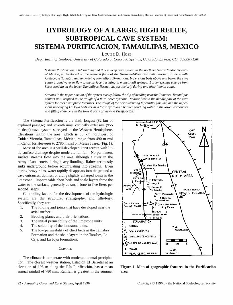
22 • Journal of Caves and Karst Studies, April 1996
HYDROLOGY OF A LARGE, HIGH RELIEF,SUBTROPICAL CAVE SYSTEM:
SISTEMA PURIFICACION, TAMAULIPAS, MEXICOLOUISE D. HOSE
Department of Geology, University of Colorado at Colorado Springs, Colorado Springs, CO 80933-7150
Sistema Purificación, a 82 km long and 955 m deep cave system in the northern Sierra Madre Orientalof México, is developed on the western flank of the Huizachal-Peregrina anticlinorium in the middleCretaceous Tamabra and underlying Tamaulipas Formations. Impervious beds above and below the cavecause groundwater to flow to the surface, resulting in many small springs. Larger springs emerge fromkarst conduits in the lower Tamaulipas Formation, particularly during and after intense rains.
Streams in the upper portion of the system mostly follow the dip of bedding near the Tamabra-Tamaulipascontact until trapped in the trough of a third-order syncline. Vadose flow in the middle part of the cavesystem follows axial plane fractures. The trough of the north-trending Infiernillo syncline, and the imper-vious underlying La Joya beds act as a local hydrologic barrier perching water in the lower carbonatesand filling chambers in the lowest parts of Sistema Purificación.
Figure 1. Map of geographic features in the Purificaciónarea.
The Sistema Purificación is the sixth longest (82 km ofexplored passage) and seventh most vertically extensive (955m deep) cave system surveyed in the Western Hemisphere.Elevations within the area, which is 50 km northwest ofCuidad Victoria, Tamaulipas, México, range from 490 m mslin Cañon los Hervores to 2780 m msl on Mesas Juárez (Fig. 1).
Most of the area is a well-developed karst terrain with lit-tle surface drainage despite moderate rainfall. No permanentsurface streams flow into the area although a river in theArroyo Luna enters during heavy flooding. Rainwater mostlysinks underground before accumulating into streams. Evenduring heavy rains, water rapidly disappears into the ground atcave entrances, dolines, or along slightly enlarged joints in thelimestone. Impermeable chert beds and shale layers force thewater to the surface, generally as small (one to five liters persecond) seeps.
Controlling factors for the development of the hydrologicsystem are the structure, stratigraphy, and lithology.Specifically, they are:
1. The folding and joints that have developed near the axial surface.
2. Bedding planes and their orientations.3. The initial permeability of the limestone units.4. The solubility of the limestone units.5. The low permeability of chert beds in the Tamabra
Formation and the shale layers in the Taraíses, La Caja, and La Joya Formations.
CLIMATE
The climate is temperate with moderate annual precipita-tion. The closest weather station, Estación El Barretal at anelevation of 196 m along the Río Purificación, has a meanannual rainfall of 780 mm. Rainfall is greatest in the summer
Hose, Louise D.— Hydrology of a Large, High-Relief, Sub-Tropical Cave System: Sistema Purificación, Tamaulipas, Mexico. Journal of Caves and Karst Studies 58(1):22-29.
Copyright © 1996 by the National Speleological Society

Journal of Caves and Karst Studies, April 1996 • 23
months and the dry season extends from approximatelyNovember through March (Fig. 2). The surface is rugged andmostly a pine-oak forest. Frost is common during winter nightsbut snow is rare. Moisture from the coastal plain to the eastoften causes clouds to engulf the mountains and humid, sub-tropical undergrowth covers shaded areas.
GEOLOGIC SETTING
The Purificación area is on the western flank of the approx-imately north-south-trending Huizachal-Peregrina anticlinori-um (first-order fold). Differential compression caused by thebroad folding of the range in front of the Laramide Thrust Beltresulted in a major, second-order syncline called Sinclinal deInfiernillo about one kilometer west of the cave. This foldcaused abundant third-order folds that significantly influencethe development of the cave system .
The cave is contained within an ~800 m thick sequence ofUpper Jurassic to middle Cretaceous marine sedimentaryrocks, mostly carbonates (Carrillo-Bravo, 1961). Detaileddescriptions of the stratigraphy and structure of the area areprovided (Hose, 1996).
SURFACE DRAINAGE
There is no surface water flowing into the area and allsprings, with the exception of Los Hervores, return under-ground within the central study area. During and after heavyrains, surface water flows down Arroyo Luna. Runoff alsofloods the subterranean conduit system and the excess waterflows through the lower surface canyon, el Infiernillo. Allwater ultimately joins the Río Purificación to the north (Fig. 1)and flows eastward to the Gulf of Mexico.
SINKS (INPUT AREAS)
Water flows underground at sinks that are common in thecarbonate terrains. Most sinks are fractures in the rocks. Someare only a few centimeters across while others are dolines tensof meters in diameter and greater than 100 meters deep. A fewsinks are also the entrances to large caves (Sumidero deOyamel) or deep pits (Pozo Obscuro). Many of the largerdolines have vegetated floors.
Sinks in the highest unit in the area, the TamabraFormation, captures surface water before any large streamsform, even during heavy rains. The water enters fissures andcaves and in many places joins the streams in SistemaPurificación. The karst in the region is sufficiently developedto pirate rainfall quickly underground as nearly diffuse inputand accounts for the lack of surface streams.
The underlying Tamaulipas Formation does not have anycave entrances that take water and surface water generallyenters the subterranean system as diffuse flow through smallfissures. However, at several places in the Cañones el
Figure 2. Average monthly rainfall at El Barretal,Tamaulipas, México over a sixteen year period (1960 to1975).
Infiernillo and los Hervores, large streams sink in the gravelstreambed within the Tamaulipas. Surface streams flowbeyond these points after heavy rains either because the con-duit system is not sufficiently developed to handle the flow orinput zones are partially blocked.
The shale beds in the Taraíses and La Caja Formationsbelow the Tamaulipas inhibit the development of karst con-duits. Surface water goes underground in a diffuse manner,often reappearing on the surface above shale beds. Dolineswith vegetation and soil on the bottoms are common in the LaCaja near Galindo. Water flows quickly into the subsurfaceand does not pool at the bottom of these depressions.
Surface streams on the Cretaceous carbonate terrains arerare throughout the surrounding mountains. While this studyincludes the surface overlying all of the known passage ofSistema Purificación, the total system probably extendsbeyond these boundaries to the south. The plateaus of MesasJuárez have well-developed karst surfaces that pirate rainfallunderground (Fig. 3). The probable destination of that water isSistema Purificación.
SPRINGS (DISCHARGE AREAS)
Two factors force the subterranean water to the surface.The more common reason is that water, following a path alongfractures and bedding planes enlarged by dissolution, encoun-ters a chert or shale bed with low permeability and is forced tothe surface. The second, and larger, type of spring only flowsafter heavy rains overload the lower, phreatic portion ofSistema Purificación.
Springs within the Tamabra Formation are small and resultfrom groundwater moving through solutionally enlarged frac-tures until reaching an insoluble and impermeable chert bedwhere the water is perched and sometimes overflows to thesurface. These springs are important water supplies to the
HOSE

24 • Journal of Caves and Karst Studies, April 1996
people living nearby but they occasionally cease flowing in thespring months after the relatively dry winter.
Karst floodwater springs are restricted to the lower part ofthe Tamaulipas Formation. Four springs are known to flowafter heavy rains. They are within 400 m of each other, nearthe head of Cañon el Infiernillo. Water issues from theentrance to Cueva el Infiernillo as a result of a rise in the watertable during and after heavy rain. The cave entrance has thehighest elevation of the four springs and is the first to quitflowing as the local water table level recedes. The other threeflow for periods of up to several months, the lowest in eleva-tion flowing for the longest period. Their geographic locationsand behavior indicate a connection with the phreatic system inthe cave.
A permanent spring of about 30 liters per second base flowrises in Cañon los Hervores but sinks into the gravel of thestreambed before the canyon joins the Río Purificación. LosHervores is a vauclusian, or boiling, spring. Water wells upthrough a tube in either the lowest Tamaulipas or highestTaraíses limestones under hydrostatic pressure. The forcedflow causes a “boiling” effect, for which the spring is named.Such springs have been interpreted as rising from large under-ground reservoirs (Sweeting, 1973). This spring, the largestpermanent water source in the central study area, is along thehinge line of one of the many tight, third-order anticlines westof Cañon el Infiernillo (Hose, 1996). The source of the flow isprobably a streambed gravel and sand sink about 1500 mupstream and other sinks further south in Arroyo Luna. As thespring is located west of the second-order Infiernillo synclinetrough, it is doubtful that the water in Sistema Purificaciónfinds its way to this spring. Arroyo Luna drains 228 km² ofsurface area upstream from Los Hervores. While permanentstreams do not flow through most of the channel, there are sev-eral permanent stream segments that rise and sink upstreamfrom Los Hervores. This water and phreatic flow through thelimestone near the stream channel are probably the sources ofLos Hervores.
Figure 3. Karst field on Mesas Juárez.
All of the known springs in Arroyo Luna and Cañon losHervores are near the Tamaulipas-Taraíses contact. The wateris apparently forced to the surface by the shale beds in theTaraíses Formation. The spring water flows along the surfacechannel to the point where the shale beds in the TaraísesFormation dip underground. Where the water again flows overthe nearly homogeneous Tamaulipas Formation, the streamsinks in the stream alluvium and small fractures in the lime-stone.
The only other springs near the Tamaulipas-Taraíses con-tact are near La Canoa. There are several small seeps formedby groundwater flowing down dip above shale partings withinthe limestone until the water intersects the cliff. Unlike othersprings in the area, these springs are supersaturated withrespect to calcite when they reach the surface and large traver-tine deposits have formed below them.
There are many small springs and seeps in the limestoneand interbedded shale of the Taraíses and La Caja Formations.They are the result of flow along bedding planes and fractureswhere groundwater is perched above shale layers. Many ofthese springs do not flow in the relatively dry spring months.Nearly permanent springs of this type are about 200 m west ofLa Curva, 300 m southwest of Puerto Purificación, 300 m westof Galindo, and in Cañon los Hervores.
The shale beds within the La Joya Formation cause smallsprings throughout its exposures. Groundwater passes throughthe sandstone and conglomerate beds as diffuse flow but isperched above the shale layers. Flow continues downdip untilit reaches the surface. The largest spring in the La JoyaFormation within the central study area is about ten metersbelow the contact of the La Caja and the La Joya Formations(1000 m msl) in the upper Cañon el Infiernillo. This is theprobable resurgence of the Sistema Purificación. The risingwater continues to flow northward along the surface channel asit crosses the outcrops of the La Joya and La Caja Formationsdownstream. The stream sinks downstream in alluvium abovebedrock of either the Taraíses or Tamaulipas Formations.
During and after heavy rains, the flow from springs inCañones los Hervores and el Infiernillo is too large to be han-dled by the sinks. At these times, some of the water sinks andthe remainder continues to flow across the limestone in the sur-face channels. However, even at these times the streams sinkagain, to the north of the central study area. Whether surfaceflow is ever continuous to the Nacimiento del Río Purificaciónduring intense rainfall, such as hurricanes, is not known.
The waters from Sistema Purificación, Cañon el Infiernillo,and Cañon los Hervores probably surface as part of theNacimiento del Río Purificación, about 12 km north of the cen-tral study area. This large spring is the source of the large,southernmost tributary that makes up the Río Purificación(Fig. 4). The quantity of water and the different chemicalcomponents indicate that the Nacimiento receives water, atleast in part, from different terrains than the Purificación area(Table 1).
HYDROLOGY OF SISTEMA PURIFICACIÓN, TAMAULIPAS, MEXICO

Journal of Caves and Karst Studies, April 1996 • 25
Figure 4. Nacimiento del Río Purificación. Water risesfrom fissures at the base of the cliff.
SAMPLE LOCATION ELEVATION pH Conductivity oC Fe Mg Ca Na K HCO3 SO4 Cl log PCO2
Upper SpringsPW2 Allarines 1980 m 7.4 210 16 0 5 105 4 <0.5 85 4 <50 -2.5
PW5 Conrado 1945 m 7.1 220 13 0 7 104 1 1.9 85 <1 <50 -2.2Castillo Well
CavePW3 Laguna Verde 1806 m 8.1 135 16 0 11 95 2 1.0 82 4 — -3.2
PW8 World Beyond 1715 m 8.0 170 16 0 20 83 1 <0.5 73 2 <50 -3.1
PW4 Turkey Lake 1296 m — — 17 0 18 53 1 <0.5 — <1 <50 -3.3
PW6 Isopod River 1290 m 8.3 210 17 0 27 77 1 <0.5 92 3 <50 -3.3
PW12 Main Sump 1070 m 8.3 190 17.25 0 27 85 1 <0.5 86 3 <50 -3.4
Lower SpringsPW11 Canon El 635 m 8.5 200 21.5 0 18 73 1 <0.5 73 2 <50 -3.6
Infiernillo
PW9 Arroyo Luna 530 m 8.2 175 22 0 15 87 1 <0.5 79 0 <50 -3.3
PW10 Los Hervores 490 m — — 18 0 9 64 1 <0.5 — <1 <50 —(Fall 1979)
PW1 Los Hervores 490 m 7.8 200 19.5 0 17 90 1 <0.5 85 <1 <50 -2.9
Table 1. Hydrochemistry of the Sistema Purificación area. Samples PW9 and PW10 are interpreted by this study to not beassociated with the Purificación system. Sample 7 is a major resurgence that drains a large portion of the mountain range,probably including waters from the Purificación system.
HYDROLOGY OF SISTEMA PURIFICACION
The hydrologic system of Sistema Purificación can bedivided into three components: 1. input streams in the uppercave; 2. middle cave streams; and 3. phreatic system and lowercave.
UPPER CAVE
Input streams, commonly within the Tamabra Formation,generally flow from east to west down the dip of beddingplanes along intersecting fractures in the limestone. Thesestreams are small and have base level flows of only a few litersper second or less. The Valkyrie River, First Stream, and RíoVerde are permanent input streams which have unknownsources and destinations (Fig. 5). They probably result fromcollections of diffuse flow, but the water has not been traced.Many other smaller streams flow during, and for a few daysafter, heavy rains. The input streams flow westward to thetrough in bedding caused by the third-order syncline at theCanal and the Nose Dives. Water that has penetrated to theTamabra-Tamaulipas contact is pooled in this trough, formingtwo near-sumps.
MIDDLE CAVE
Several stream segments make up the middle cave streams.These streams flow along a trend between N5°W and N10°W,following fractures near the axial surfaces of the anticline andsyncline that crop out at the surface near Conrado Castillo(Hose, 1996). This axial plane cleavage has provided zones inthe limestone of high permeability, enhancing water flow, dis-solution, and the development of conduits along these joints.The streams mostly flow parallel to the folds, along the strikeof beds and lose elevation along joints.
HOSE

26 • Journal of Caves and Karst Studies, April 1996
Figure 5. Plan view of Sistema Purificación showing crests and troughs of major folds.
Dragon River, The World Beyond, Nile River, and IsopodRiver are the major middle cave streams. Dragon River isformed in the lower part of the Tamabra Formation.Compression of the limestone near the synclinal axial planeresulted in numerous smaller, complementary folds, exposedin the walls and ceilings of the cave passage. Whether DragonRiver water joins the World Beyond stream, or where the watermay reappear within the system, is unknown.
The stream in the World Beyond flows along strike near thetop of the Tamaulipas Formation. Water from the WorldBeyond passes into a pinch before reappearing slightly westand to the north where it flows down the Angel’s Staircase, los-ing elevation through joints. The terminal sump of the Angel’sStaircase is lower than Lake Victoria, the source of the NileRiver. It is not known where, or if, the World Beyond waterreappears in the known cave.
Tens of liters of water per second were added to the WorldBeyond at about six sites during a heavy, 12-hour, summerrain (Hose, 1994). Most of the sites are marked by flowstonedeposits (Oztotl’s Throne and Hall of Angels) and/or minordripping during the dry season. Sites of numerous smallerwaterfalls during the flood have no flow during the dry season.Densely fractured rock along the synclinal axial plane abovethe World Beyond provides convenient, dispersed paths forrapid input into the system during heavy rains.
The Nile River flows through nearly flat-beddedTamaulipas limestone near a décollement under the third-orderfolds. The beds are only gently folded, but the stream flowsparallel to the axial surface along complementary fractures.Flow in the Nile River in the dry season (early spring) has beenestimated to be between eight and 30 liters per second. TheNile River is last seen in a pinch and its destination is uncer-
tain.Isopod River is approximately the same size as the Nile to
its south and flows through the Tamaulipas Formation in astructurally similar position. Although a hydrologic connec-tion has not been proven, it is likely that the two streams arethe same water and much of the missing stream segment flowsthrough the breakdown on the floor of the Netherhall. TheIsopod River passes through a sump and re-emerges as theBabylon River (Sprouse, 1994, written communication).
Four new streams have been discovered and explored in themiddle portion of the cave during the last decade. The rela-tionships between Midnight, Flaming Nose, Tokamak/Texas,and Enigma streams have not yet been determined.
LOWER CAVE
The lowest part of the exposed hydrologic system is agroup of sumps in Cueva el Infiernillo. Four sumps are knownand have water at or near the same elevation at any given time,although the water levels appear to constantly fluctuate. Thesumps are the manifestation of a perched water table thatresults from the underlying impermeable shales in the Taraíses,La Caja, and La Joya Formations, and the trough formed by theInfiernillo syncline, about 200 m west of the sumps. Recentunderwater exploration of two of the sumps reached ~1005 mmsl, only about five meters above the probable resurgence forthe system in Cañon el Infiernillo. Exploration ended at alarge, upward sloping breakdown pile (Sloan, 1993). About 40m above this depth, the diver noted that “the wall no longerappeared as solid rock” and instead appeared to be calciteencrusted mud, possibly marking the transition from theTara’ses limestone to the underlying, argillaceous La CajaFormation.
HYDROLOGY OF SISTEMA PURIFICACIÓN, TAMAULIPAS, MEXICO

Journal of Caves and Karst Studies, April 1996 • 27
FLOODING EVENTS
During and after hurricanes and other heavy rains, many ofthe explored passages are flooded. One flood that resultedfrom a storm of 19 cm of rain in a 50 hour period in ConradoCastillo was observed by the author in December 1979 (Hose,1994). Input and middle cave streams increased in volume andnew streams flowed. The Canal and the Nose Dives filled tothe ceiling and closed access to the middle cave. The middlestreams were not observed, but water-filled depressions in thecave indicated that the streams rose tens of meters into whatmust have been raging rivers. (Waterlines in the normally dryNetherhall record floods in the past where water, probablyfrom the Nile/Isopod River, has risen more than 60 m as itflowed through the breakdown-filled floor.) Most of the inputand middle streams subsided to near-normal flow levels with-in three days after the rain stopped.
The sumps in the Cueva el Infiernillo rise tens of metersduring heavy rains. Such a rise of the sumps during theDecember 1979 storm caused the system to back-up and flowout the entrance of Cueva el Infiernillo. Following a relative-ly dry summer and fall, the Main and Left-hand Sumps arebelieved to have been at approximately 1058 m msl and rose~64 m to an elevation of 1122 m msl within three-and-a-halfdays after the rain started (Fig. 6). The rise stopped at thislevel as the system found a balance between the water enteringthe sumps from the higher streams and the water leaving thesystem through the springs in Cañon el Infiernillo, includingthe large cave entrance at 1102 m msl (Fig. 7). The flood roseto ~1268 m msl in the South Trunk.
The first spring to ceased flowing after the rain stopped wasthe highest, the Cueva el Infiernillo entrance. The sump levelin the cave rapidly retreated, dropping as fast as one centime-ter per minute in a passage 12 m wide and 10 m high. The con-sequent opening of previously flooded rooms to the cave’sbarometric system caused great movement of air and resultedin an occasional roaring wind that created waves up to five mil-limeters in amplitude on the surface of the water.
By the time the water level dropped to Camp I, ~1086 mabove msl, the easternmost spring quit flowing. The middlespring was the next to dry up. The spring below the caveentrance has been observed to flow for more than two monthsafter a flood (Treacy, 1979).
The decline curve in Figure 6 is based on only five mea-sured levels of the Main and Left-hand Sumps and on high-water marks. Water in the Echo Chamber Sump was approxi-mately the same elevation as the others at all times. The dis-ruption in the curve at 170 hours may have been due to adelayed pulse of water being added from the upper system orby a change in the total area of the passages being drained. Ifa fixed amount of water is draining from the system, at levelsof small tubes with steep slopes the water will drop in eleva-tion quicker than when draining large rooms. It is possible thatlarge rooms or passages were being drained at about 170 hoursand temporarily slowed the rate of decline without a change in
Figure 6. Decline curve for the December 1979 flood. Dataused in the graph were measurements made on the MainSump/Left-hand Sump as the combined sumps recededfrom the Four-Way Junction area in Cueva el Infiernillo.
the input/output ratio for the system.
HYDROCHEMISTRY
The chemical analyses presented in Table 1 are the resultsfrom a single sampling from each site during March and April1980, except Los Hervores which was sampled on two occa-sions. The waters were collected in new, clean plastic bottlesthat were rinsed with the sample waters and drained threetimes before collecting. The bottles were filled and cappedwhile held at least 15 cm below the water surface. A secondsample bottle was filled and nitric acid added later to lower thepH and prevent precipitation of calcite. The samples were notfiltered, thus the reported values of Ca+2 represent total calci-um, includiing particulates. The temperatures of the waterswere measured by a field thermometer graduated in 1° C inter-vals. Values of pH were determined by using a digital read-outpH meter using double buffer calibration which is accurate towithin ±0.05 units. The meter was calibrated for each reading,and buffers were at the same temperature as the samples.Conductivities, indicating the total dissolved solids contents,were measured by a small field conductivity meter. All thesemeasurements, except pH for the Laguna Verde, WorldBeyond, and Isopod River waters, were done at the sites.Bicarbonate measurements, either at the sites or within a half-hour after sampling, were made by potentiometric titrationwith an estimated error of ±10% (Hess, 1994, written commu-
HOSE

28 • Journal of Caves and Karst Studies, April 1996
Figure 7. Entrance to Cueva de Infiernillo. An ephemeralpool of water rises from behind boulders to the immediateright of the photograph.
nication). Cations were determined later by an atomic absorp-tion spectrophotometer, and sulfate and chloride concentra-tions were measured using a Hach water quality kit in the lab.Several samples contained less sulfate and chloride than theminimum detection limits of one milligram per liter and 50milligrams per liter, respectively.
All of the water collected in the central study area had alow total dissolved solids content and was slightly alkaline(Table 1). All but sample PW1 were collected in the spring of1980 during low water flow and while the levels in the sumpswere dropping. Iron, sodium, potassium, and chloride concen-trations were generally too low to be accurately measured bythe methods used. Sulfate concentrations were also low, evenin the sump and lower springs, and indicate that the waters donot reach the level of the evaporites of the Olvido Formation,if they exist under Arroyo Luna and the Cerro Los Puertosridge.
Samples PW2 and PW5 had relatively high calcium values
and were collected at the two highest elevations. Both sourcesare water forced to the surface, or near it, by beds of chert inthe Tamabra Formation. Agua los Allarines is a flowing springand the Conrado Castillo well, where water pools in a smallsolution pocket, is only about three meters deep. The lower pHof these two samples probably indicates relatively short pas-sage in the underground and close proximity to the sourceareas.
The partial pressure of carbon dioxide progressivelydecreases with decreasing elevation. It is important to note,however, that these samples represent low, dry season flow,which is probably not directly relevant to speleogenesis. Dryseason samples probably accentuate the contributions of dif-fuse groundwater flow and minimize the characteristics of con-duit waters. The only site sampled in Fall 1979, at the end ofthe wet season, contained 41% lower concentration of Ca andwas more than a degree Celsius lower temperature than thesame site three months into the dry season (Table 1, PW1 andPW10). These data suggest that the average residence time forthe groundwater feeding Los Hervores is much longer duringthe dry season than during the wet season. This is probablyalso true within Sistema Purificación.
One water sample (PW7) was collected and measured fromnorth of the central study area at the river resurgence,Nacimiento del Río Purificación (Fig. 1). The water showedsubstantially different chemical concentrations than the othersin this study. Although the waters from Infiernillo canyon andfrom Los Hervores probably re-emerge at the Nacimiento, thechemical signatures indicate other sources as well. A sulfateconcentration of 100 milligrams per liter may result from dis-solution of evaporite beds in the Olvido Formation.
DISCUSSION
The central study area is divided into several hydrologicsystems, all of which ultimately drain into the Río Purificaciónto the northeast (Fig. 1). Rain falling near the eastern bound-ary flows along the surface to the east, over the La JoyaFormation. The shale beds in this unit are nearly impermeableand forcing the rising of many springs. Similarly, the shalebeds in the La Caja and Taraíses Formations commonly forcegroundwater to the surface. The La Caja and Taraíses are poorcave formers and probably cause the restrictions in the phreat-ic passages of Sistema Purificación that force the water to riseand overflow out Cueva el Infiernillo during heavy rains.However, the system’s water at base flow apparently is notforced to the surface until it reaches the La Joya Formation andemerges at the bottom of the La Caja at ~1000 m msl in Cañonel Infiernillo.
Bedding planes and joints in the thick-bedded TamaulipasFormation provide good conduits. Water flows down the dip,along the intersection of joints and bedding planes, on theflanks of folds. Near the axial surfaces of the anticlines andsynclines, the passage development is nearly along strike, typ-
HYDROLOGY OF SISTEMA PURIFICACIÓN, TAMAULIPAS, MEXICO

Journal of Caves and Karst Studies, April 1996 • 29
ically along the intersection of a bedding plane and a joint par-allel to the folding, or dropping along fractures.
Groundwater flow in the Tamabra is enhanced by its sus-ceptibility to karst development but inhibited by beds of chert.Water entering the ground above the chert beds either contin-ues flowing downward through fractures in the chert near axialsurfaces, as in the physically unconnected cave Sótano de laCuchilla, or is forced to the surface after perching on the chert.Surface flow returns to the subterranean system after passingthe chert bed. Water entering the Tamabra Formation belowthe bedded chert gathers in karst conduits and joins the karsthydrologic systems in the underlying Tamaulipas Formation.
The water flowing out of the central study area travels intwo directions. Along the eastern boundary, the water leavingthe area mostly travels on the surface to the east into CañonesEl Rosario and El Olmo, and Cañada Guayabas. All thesestreams continue eastward to join the Río Purificación. Thewater from Sistema Purificación and Cañon el Infiernillo trav-els a subterranean route after leaving the central study area,except during floods. The flow from Los Hervores leaves thearea on the surface but also goes underground to the north dur-ing base flow conditions. Although not confirmed, this waterprobably re-emerges from the karst springs at the Nacimientodel Río Purificación, along with waters from other parts of themountain range.
The sumps in the lowest portions of Sistema Purificaciónare exposures of a localized, perched water table resultingfrom underlying, impermeable shale beds and the Infiernillosyncline to the west. The structure prevents groundwater frommigrating to the east or west. Groundwater flow is furtherslowed in its downward progress by the poor conduit-forminglimestone and interbedded shale in the Taraíses and La CajaFormations. The water probably passes through constrictedpassages in these units and emerges in Cañon el Infiernillo,approximately 800 m north of the Echo Chamber Sump.
The spring in Cañon el Infiernillo is probably only a part ofthe flow leaving Sistema Purificación. Some phreatic watermay pass through the Taraíses and La Caja Formations andpartially enters the clastic sediments of the La Joya Formation.Perched by the shale beds in this unit, some of the water over-flows at the spring in Cañon el Infiernillo. The rest of thewater probably flows through the conglomerate and sandstonebeds of the upper La Joya northward along the trough formedby the Infiernillo syncline. If the Olvido Formation is presentwest of Cañon el Infiernillo, the water may gain sulfate ions.Such water probably emerges at the Nacimiento del RíoPurificación, since none of the springs in the central study areahave measurable sulfate ion concentrations.
The Infiernillo syncline and accompanying folds west ofSistema Purificación prevent the water from joining the hydro-logic system in Arroyo Luna. The water at Los Hervores isprobably from sources west of the cave system. Intense fold-ing along the west limb of the syncline prevents water fromflowing eastward into the Purificación system.
The southern boundary of the source area for the water inSistema Purificación is unrecognized and further study isneeded to identify it. Most of the groundwater in the studyarea south of Cañon el Infiernillo and between the Infiernillosyncline and an anticline through Cerro Vaquerillo probablyenters the cave system. The source area probably extendssouth along a structural corridor approximately two or threekilometers wide.
ACKNOWLEDGEMENTS
The members of the Proyecto Espeleológico Purificaciónand the residents of the ejidos of Conrado Castillo and PuertoPurificación made this study possible. Special thanks are dueto project coordinator P.S. Sprouse. D. A. Córdoba and Z. deCserna of the Instituto de Geología provided support that wasgreatly appreciated. A grant supporting the field work wasmade by the National Speleological Society Research GrantCommittee. Dr. John W. Hess and Dr. Roger L. Jacobsonassisted with the hydrochemistry study. G. L. Atkinson pro-vided hours of interesting discussions on these topics.
REFERENCES
Carrillo-Bravo, J. (1961). Geología del Huizachal-Peregrina anticli-norio al Noroeste de Cd. Victoria, Tamaulipas. Boletín de laAsociación Mexicana de Geólogos Petroleros, XIII(1-2): 98 p.
Hose, L. D. (1996): Geology of a large, high-relief, sub-tropical cavesystem: Sistema Purificación, Tamaulipas, México. Journal ofCaves and Karst Studies, 58(1): 6-21.
Hose, L. D. (1994). Sistema Purificación in flood. Geo2, 21(2): 18-20.
Sloan, N. E. (1993). Underwater exploration in Sistema PurificaciónThe Death Coral Caver, (3): 22-25.
Sweeting, M.M. (1973). Karst Landforms. Columbia UniversityPress, New York, 362 p.
Treacy, T. (1979). Proyecto Espeleológico Purificación. Associationfor Mexican Cave Studies Activities Newsletter, (9): 6-31.
HOSE
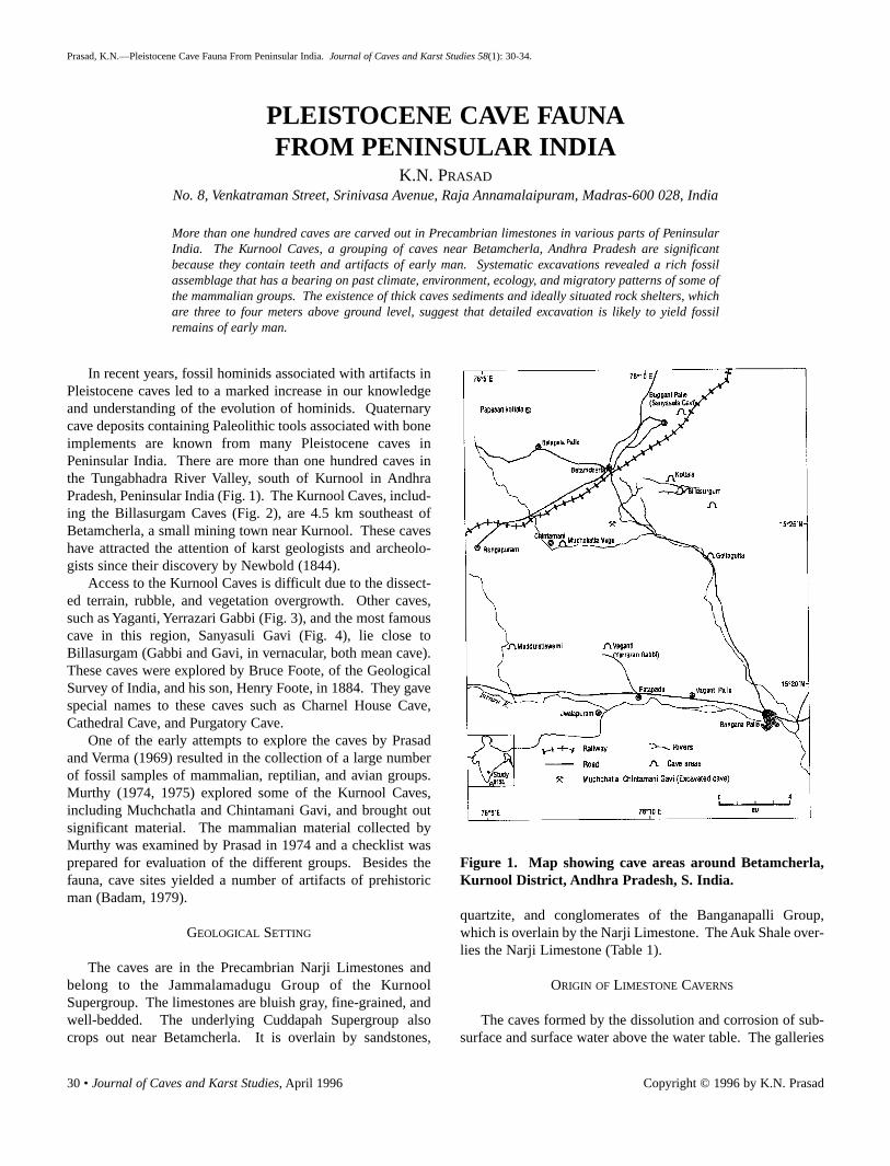
30 • Journal of Caves and Karst Studies, April 1996
PLEISTOCENE CAVE FAUNAFROM PENINSULAR INDIA
K.N. PRASAD
No. 8, Venkatraman Street, Srinivasa Avenue, Raja Annamalaipuram, Madras-600 028, India
More than one hundred caves are carved out in Precambrian limestones in various parts of PeninsularIndia. The Kurnool Caves, a grouping of caves near Betamcherla, Andhra Pradesh are significantbecause they contain teeth and artifacts of early man. Systematic excavations revealed a rich fossilassemblage that has a bearing on past climate, environment, ecology, and migratory patterns of some ofthe mammalian groups. The existence of thick caves sediments and ideally situated rock shelters, whichare three to four meters above ground level, suggest that detailed excavation is likely to yield fossilremains of early man.
In recent years, fossil hominids associated with artifacts inPleistocene caves led to a marked increase in our knowledgeand understanding of the evolution of hominids. Quaternarycave deposits containing Paleolithic tools associated with boneimplements are known from many Pleistocene caves inPeninsular India. There are more than one hundred caves inthe Tungabhadra River Valley, south of Kurnool in AndhraPradesh, Peninsular India (Fig. 1). The Kurnool Caves, includ-ing the Billasurgam Caves (Fig. 2), are 4.5 km southeast ofBetamcherla, a small mining town near Kurnool. These caveshave attracted the attention of karst geologists and archeolo-gists since their discovery by Newbold (1844).
Access to the Kurnool Caves is difficult due to the dissect-ed terrain, rubble, and vegetation overgrowth. Other caves,such as Yaganti, Yerrazari Gabbi (Fig. 3), and the most famouscave in this region, Sanyasuli Gavi (Fig. 4), lie close toBillasurgam (Gabbi and Gavi, in vernacular, both mean cave).These caves were explored by Bruce Foote, of the GeologicalSurvey of India, and his son, Henry Foote, in 1884. They gavespecial names to these caves such as Charnel House Cave,Cathedral Cave, and Purgatory Cave.
One of the early attempts to explore the caves by Prasadand Verma (1969) resulted in the collection of a large numberof fossil samples of mammalian, reptilian, and avian groups.Murthy (1974, 1975) explored some of the Kurnool Caves,including Muchchatla and Chintamani Gavi, and brought outsignificant material. The mammalian material collected byMurthy was examined by Prasad in 1974 and a checklist wasprepared for evaluation of the different groups. Besides thefauna, cave sites yielded a number of artifacts of prehistoricman (Badam, 1979).
GEOLOGICAL SETTING
The caves are in the Precambrian Narji Limestones andbelong to the Jammalamadugu Group of the KurnoolSupergroup. The limestones are bluish gray, fine-grained, andwell-bedded. The underlying Cuddapah Supergroup alsocrops out near Betamcherla. It is overlain by sandstones,
Figure 1. Map showing cave areas around Betamcherla,Kurnool District, Andhra Pradesh, S. India.
quartzite, and conglomerates of the Banganapalli Group,which is overlain by the Narji Limestone. The Auk Shale over-lies the Narji Limestone (Table 1).
ORIGIN OF LIMESTONE CAVERNS
The caves formed by the dissolution and corrosion of sub-surface and surface water above the water table. The galleries
Prasad, K.N.—Pleistocene Cave Fauna From Peninsular India. Journal of Caves and Karst Studies 58(1): 30-34.
Copyright © 1996 by K.N. Prasad

Journal of Caves and Karst Studies, April 1996 • 31
Figure 2. A Billasurgam Cave.
Figure 3. Yerrazari Gavi.
Figure 4. Sanyasula Gavi.
Table 1.
THE KURNOOL SYSTEMGroups FormationsKundair Nandyal Shales
Koilkuntla LimestonePaniam Pinnacled QuartziteJammalamadugu Auk Shale
Narji LimestoneBanganapalli Banganapalli Sandstone
of the caverns developed successively at different levels. Thehighest passages formed by graded water table streams, whichwidened by lateral erosion. The several caves studied arelocated in steep hill slopes ~21 m above the valley floors. Ifthe caves were coeval and dissolved by streams, it would bepossible to estimate downcutting rates by streams in variouscaves.
ENVIRONMENT
The caves are located in limestone escarpments. Passagesas low as a meter in height extend deep into the limestone. Thefloors are characterized by thick sediments of clays, stalag-mites, stalactites, and cemented limestone blocks formingbreccias. The plateau and hill slopes have a grass and xero-phytic cover of deciduous type representing a semi-arid envi-ronment. Modern fauna are confined to animals such asHystrix, Vivvera, Lepus, Felis, and Manis.
PRASAD
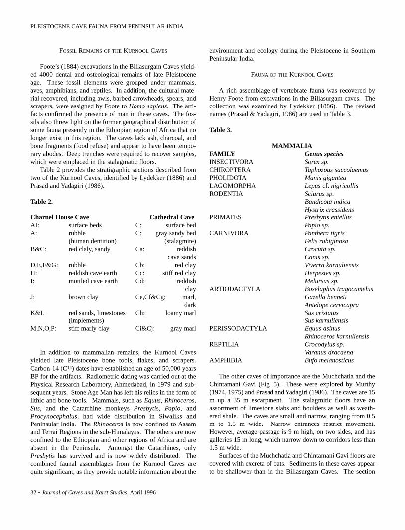
32 • Journal of Caves and Karst Studies, April 1996
FOSSIL REMAINS OF THE KURNOOL CAVES
Foote’s (1884) excavations in the Billasurgam Caves yield-ed 4000 dental and osteological remains of late Pleistoceneage. These fossil elements were grouped under mammals,aves, amphibians, and reptiles. In addition, the cultural mate-rial recovered, including awls, barbed arrowheads, spears, andscrapers, were assigned by Foote to Homo sapiens. The arti-facts confirmed the presence of man in these caves. The fos-sils also threw light on the former geographical distribution ofsome fauna presently in the Ethiopian region of Africa that nolonger exist in this region. The caves lack ash, charcoal, andbone fragments (food refuse) and appear to have been tempo-rary abodes. Deep trenches were required to recover samples,which were emplaced in the stalagmatic floors.
Table 2 provides the stratigraphic sections described fromtwo of the Kurnool Caves, identified by Lydekker (1886) andPrasad and Yadagiri (1986).
Table 2.
Charnel House Cave Cathedral CaveAI: surface beds C: surface bedA: rubble C: gray sandy bed
(human dentition) (stalagmite)B&C: red claly, sandy Ca: reddish
cave sandsD,E,F&G: rubble Cb: red clayH: reddish cave earth Cc: stiff red clayI: mottled cave earth Cd: reddish
clayJ: brown clay Ce,Cf&Cg: marl,
darkK&L red sands, limestones Ch: loamy marl
(implements)M,N,O,P: stiff marly clay Ci&Cj: gray marl
In addition to mammalian remains, the Kurnool Cavesyielded late Pleistocene bone tools, flakes, and scrapers.Carbon-14 (C14) dates have established an age of 50,000 yearsBP for the artifacts. Radiometric dating was carried out at thePhysical Research Laboratory, Ahmedabad, in 1979 and sub-sequent years. Stone Age Man has left his relics in the form oflithic and bone tools. Mammals, such as Equus, Rhinoceros,Sus, and the Catarrhine monkeys Presbytis, Papio, andProcynocephalus, had wide distribution in Siwaliks andPeninsular India. The Rhinoceros is now confined to Assamand Terrai Regions in the sub-Himalayas. The others are nowconfined to the Ethiopian and other regions of Africa and areabsent in the Peninsula. Amongst the Catarrhines, onlyPresbytis has survived and is now widely distributed. Thecombined faunal assemblages from the Kurnool Caves arequite significant, as they provide notable information about the
environment and ecology during the Pleistocene in SouthernPeninsular India.
FAUNA OF THE KURNOOL CAVES
A rich assemblage of vertebrate fauna was recovered byHenry Foote from excavations in the Billasurgam caves. Thecollection was examined by Lydekker (1886). The revisednames (Prasad & Yadagiri, 1986) are used in Table 3.
Table 3.
MAMMALIAFAMILY Genus speciesINSECTIVORA Sorex sp.CHIROPTERA Taphozous saccolaemusPHOLIDOTA Manis giganteaLAGOMORPHA Lepus cf. nigricollisRODENTIA Sciurus sp.
Bandicota indicaHystrix crassidens
PRIMATES Presbytis entellusPapio sp.
CARNIVORA Panthera tigrisFelis rubiginosaCrocuta sp.Canis sp.Viverra karnuliensisHerpestes sp.Melursus sp.
ARTIODACTYLA Boselaphus tragocamelusGazella bennetiAntelope cervicapraSus cristatusSus karnuliensis
PERISSODACTYLA Equus asinusRhinoceros karnuliensis
REPTILIA Crocodylus sp.Varanus dracaena
AMPHIBIA Bufo melanosticus
The other caves of importance are the Muchchatla and theChintamani Gavi (Fig. 5). These were explored by Murthy(1974, 1975) and Prasad and Yadagiri (1986). The caves are 15m up a 35 m escarpment. The stalagmitic floors have anassortment of limestone slabs and boulders as well as weath-ered shale. The caves are small and narrow, ranging from 0.5m to 1.5 m wide. Narrow entrances restrict movement.However, average passage is 9 m high, on two sides, and hasgalleries 15 m long, which narrow down to corridors less than1.5 m wide.
Surfaces of the Muchchatla and Chintamani Gavi floors arecovered with excreta of bats. Sediments in these caves appearto be shallower than in the Billasurgam Caves. The section
PLEISTOCENE CAVE FAUNA FROM PENINSULAR INDIA

Journal of Caves and Karst Studies, April 1996 • 33
Figure 5. The entrance to Chintamani Gavi.
observed at Chintamani Gavi is as follows:
TOP D. Clay: 25 cmC. Clay with limestone blocks: 35 cmB. Red marl: 50 cmA. Massive limestone
Table 4 illustrates the forms which have been identified inthe collection from Chintamani Gavi, close to the BillasurgamCaves.
The cave floors were divided into three layers by Murthy(1974, 1975). These layers contain cultural elements (Table 5).
Based on the artifacts, the lithic industry from ChintamaniGavi indicates the utilization of flakes, blades, cores, and ham-merstones. The bone tool assemblage is made up of chisels,scrapers, and barbs. They exhibit an Upper Paleolithic tradi-tion and the layers do not show any typological or evolution-ary variation.
CHANDRAPALLE CAVE
One of the largest caves in this region is the ChandrapalleCave, ~12 km east of Peapally and ~50 km south-southeast ofBangana Palle. The cave is in Precambrian Cuddapah
Table 4.
MAMMALIA
FAMILY Genus speciesPRIMATES Presbytis entellusRODENTIA Nesokia bandicota
Hystrix crassidensPERISSODACTYLA Equus sp.
Equus asinusARTIODACTYLA Boselaphus tragocamelus
Bos sp.Antelope cervicapraSus cristatus
CARNIVORA Viverra karnuliensisFelis sp.
Limestones. The roughly 1 m wide cave entrance is ~24 m upa cliff face. The passage widens about 15 m into the cave andthe roof is well over 18 m high. A stalagmitic floor with per-manent water pools lies beyond. A well-preserved specimenof an Ursus bear skull (Fig. 6) was collected from this cave bythe Archeological Department of Andhra Pradesh and wasexamined by the author. Two fossil species of Ursus areknown from India: Ursus theobaldi from the Siwaliks ofKangra, Himachal Pradesh, and Ursus namadicus fromNarmada Basin, Central India. The Chandrapalle Cave speci-men has been described as a new species of Ursus footei(Prasad and Yadagiri, 1986).
Table 5.
FLOOR DATA LAYER LAYER LAYER TOTAL1 2 3
Cultural ElementsLithic Industry 13 23 187 223Bone Tool Industry 125 621 1257 2003
FaunaDental 23 54 140 217Osteological 7 15 51 73
Total 168 713 1635 2516(6.7%) (28.3%) (65.0%)
PALEOECOLOGY
The area around Betamcherla presently is semi-arid withscanty vegetation and few rivers. However, the excavatedfauna indicate that the moderately hilly terrain was coveredwith trees in the late Pleistocene. Rivers and streams in thebasin support the forest. Tall grass prevailed in the plateaucountry.
PRASAD

34 • Journal of Caves and Karst Studies, April 1996
Figure 6. Ursus footei skull from Chandrapalle Cave.
The presence of Antelope, Gazella, Cervus, Ursus, andBoselaphus suggests that forest conditions existed on hillslopes. Bubalus and Bos thrived on forested regions, whichwas broken up by streams with open grasslands on the banks.The presence of Presbytis entellus, the arboreal HanumanLangur, indicates a deciduous forest vegetation. They movedin groups and inhabited rocks and cliffs. The convincing proofof low forested hills and swamps having abundant vegetationis in the occurrence of Rhinoceros karnuliensis. R. karnulien-sis is now absent in Peninsular India and is confined to the rainforests of Assam.
CONCLUSIONS
The study of the Kurnool Caves fauna is important.Sediments are as much as 25 m thick in some of the caves andtheir stratigraphy reveals considerable information on thePleistocene history of the caves. The presence of rock sheltersprovides a basis for exploration of fossil remains of early man.So far, a portion of a jaw with dentition and an isolated toothhave been recovered from the cave floors. They may beassigned to Homo sapiens.
ACKNOWLEDGMENTS
I would like to thank my former colleagues, Dr. C.V.N.K.Rao and Dr. P. Yadagiri, of the Geological Survey of India andDr. G.L. Badam of Deccan College, Pune for helpful discus-sions. Thanks are due to the Geological Survey of India,Madras and Calcutta, for library facilities and examination ofearlier collections. The research was supported by the BoiseFund, Oxford University. I thank Dr. George N. Huppert andBetty Wheeler, both of the Department of Geography andEarth Science, University of Wisconsin-La Crosse for kindlyediting the paper and seeing it through the press. Appreciationis also expressed to Dr. Greg Chu, of the same department, forcomputer drafting the map.
REFERENCES
Badam, G.L. (1979). Pleistocene Fauna of India. Special Publication(no number): 1-245. Deccan College, Post Graduate ResearchInstitute, Pune.
Foote, R.B. (1884). Foote’s work at the Billasurgam Caves. Records,Geological Survey of India, 17(4): 200-208.
Lydekker, R. (1886). The Fauna of Kurnool Caves. PalaeontologiaIndica Series C. 4(2): 23-58.
Murthy, M.L.K. (1974). A Late Pleistocene Cave Site in SouthernIndia. Proceedings of the American Philosophical Society,118(2): 196-230.
Murthy, M.L.K. (1975). Late Pleistocene Fauna of Kurnool Caves,South India. In A.T. Clason (Ed.), Archaezoological Studies: 132-138. Special publication, North Holland Publishing Company,Amsterdam and New York.
Newbold, T.J. (1844). Notes on the Osseous Breccia and deposit inthe caves of Billasurgam, Southern India. Journal Asiatic Societyof Bengal, 13(2): 610-615.
Prasad, K.N. & Verma, K.K. (1969). The Kurnool Cave Fauna.Unpublished progress report.
Prasad, K.N. & Yadagiri, P. (1986). Pleistocene Cave Fauna, KurnoolDistrict, Andhra Pradesh, Records, Geological Survey of India,115(5): 71-77.
PLEISTOCENE CAVE FAUNA FROM PENINSULAR INDIA

Journal of Caves and Karst Studies, April 1996 • 35
EXTREMELY LOW FREQUENCYRADIO EMISSIONS IN BAT CAVES
WALTON C. KOEMEL
Route 2, Box 173, Lamesa, Texas 79331
Bats produce very low frequency (VLF) radio pulses and display magnetic qualities. Extremely low fre-quency (ELF) radio emissions were observed inside bat caves. Ground return currents from 60 Hz ACpower systems run through the ceiling of some bat caves.
MATERIALS AND METHODS
I developed a metal antenna tuned radio frequency (TRF)receiver that could be tuned to the radio electric wave to theexclusion of a microphone-detected audio wave (Koemel &Callahan, 1994). It is a wide band receiver, but only frequen-cies between 20 Hz and 18,000 Hz can be heard in the ear-phone. Atmospheric radio emission observations were madein an area not affected by 60 Hz AC power systems.
In July, 1993, I began observing extremely low frequencyand very low frequency (ELF\VLF) radio emissions in cavesand VLF radio pulses produced by flying bats. The pulses pro-duced by bats were observed only during bat flight activity.This article contains preliminary data obtained with the TRFreceiver.
METHOD OF RECORDING OBSERVATIONS
I recorded the observed ELF radio emissions by attachingan electric-shielded patch cable from the TRF receiver ear-phone jack to the microphone input jack of a computer-com-patible cassette tape recorder set in the RECORD mode. Thisconnection prevented the tape recorder from recording sound.I held the TRF receiver motionless while recording ELF radioemissions. I kept my body in contact with the TRF receiverchassis ground, while making observations, to prevent staticdischarges from “hand capacitance”.
COMPUTER ANALYSIS OF EMISSIONS
I used a Heath-Zenith digital computer oscilloscope(Model No. IC-4802, Heath, Bent Harbor, MI) driven by aTandy 1000-HX computer and Tandy JP 250 printer (Tandy,Fort Worth, TX 76102) to analyze the radio emissions. Iplayed the tape recordings into the shielded oscilloscope probeby adapting the probe to the earphone jack of the cassette taperecorder. This connection prevented sound and static fromentering the oscilloscope. The oscilloscope used the computermonitor as a display screen and it can freeze the waveform onthe screen for analysis. Two movable cursors on the screenenable the operator to read the waveform frequency in hertz. Iobtained a print (17.5 by 13.5 cm) of the waveform on thescreen by entering the print code into the computer. The oscil-
loscope prints used in the following figures are from this oscil-loscope. I also used an Audio Spectrum Analyzer to identifythe frequencies in the observations.
RESULTS
I made observations at Mason Bat Cave on 17 October1994, in the afternoon, during which time the weather condi-tions included a partly cloudy sky with rain showers. Figure 1shows some of the observed ELF/VLF radio emissions in theatmosphere, including a static discharge from a rain cloud inthe area near Mason Bat Cave. The waveforms produced bybats (Figs. 8-9) were not found in the analysis of these obser-vations. ELF/VLF radio emissions of different weather condi-tions produce distinctive frequency spectra. Figure 2 showsradio emissions produced by a sand storm, Figure 3 demon-strates radio emissions produced by a blizzard, and Figure 4shows radio emissions produced by a clear moonlit night sky.I do not know if the 2,000 Hz pulse in Figure 4 is from a bat.A clear daytime sky is similar to Figure 4.
Atmospheric ELF/VLF radio emissions can be observedinside Mason Bat Cave near the ceiling. Figure 5 indicatesobserved ELF/VLF radio emissions near the cave ceiling, andFigure 6 shows ELF/VLF radio emissions near the floor ofMason Bat Cave. The radio emissions produced by the batswere not found in the analysis of these observations. Figures5 and 6 demonstrate no ground return current from 60 Hz ACpower systems running through Mason Bat Cave. Figure 7shows a strong 120 HZ radio emission near the ceiling of LairCave near Carlsbad, New Mexico. Ground return currentsfrom 60 Hz AC power systems cause this frequency. The radioemissions observed near the floor of Lair Cave were similar toFigure 6. Mason Bat Cave has a prolific bat population whileLair Cave is sparsely populated.
I observed VLF radio pulses produced by flying bats insidethese caves. They produce a “pop” sound in the TRF receiverearphone, and computer oscilloscope analysis shows theirwaveforms are different from atmospheric static discharges(Fig. 1). These pulses are multi-peaked with frequencies thatrange from 2,000 to 3,500 Hz. They last from one to three mil-liseconds (ms). Figure 8 shows a 2,500 Hz radio pulse pro-duced by a flying bat (see cursors) and Figure 9 represents a2,000 Hz radio pulse produced by a flying bat (see cursors).
Koemel, Walton C.—Extremely Low Frequency Radio Emissions in Bat Caves. Journal of Caves and Karst Studies 58(1): 35-37.
Copyright © 1996 by the National Speleological Society

36 • Journal of Caves and Karst Studies, April 1996
Figure 1. Oscilloscope recording of radio emissions in theatmosphere near Mason Bat Cave.
Figure 2. Oscilloscope recording of radio emissions pro-duced by a sand storm.
Figure 3. Oscilloscope recording of radio emissions pro-duced by a blizzard.
Figure 4. Oscilloscope recording of radio emissions pro-duced by a clear moonlit sky.
Figure 5. Oscilloscope recording of radio emission near theceiling of Mason Bat Cave.
Figure 6. Oscilloscope recording of radio emission near thefloor of Mason Bat Cave.
Bats have magnetic remanence (Buchler & Wasilewski,1985). The magnetic rotation in the northern hemisphere iscounter-clockwise, and clockwise in the southern hemisphere.Bats display magnetic qualities by flying in a counter-clock-wise rotation as they exit caves in the northern hemisphere, andby flying in a clockwise rotation as they exit caves in the south-
ern hemisphere.
CONCLUSION
Bats can use atmospheric radio emissions to detect weath-er conditions from inside a cave. Bats may be affected by 60
EXTREMELY LOW FREQUENCY RADIO EMISSIONS IN BAT CAVES

Journal of Caves and Karst Studies, April 1996 • 37
Figure 7. Oscilloscope recording of radio emission near theceiling of Lair Cave.
Figure 8. Oscilloscope recording of 2,500 Hz radio emis-sion produced by a flying bat (species unknown) (see cur-sors).
Figure 9. Oscilloscope recording of 2,000 Hz radio emis-sion produced by a flying bat (species unknown) (see cur-sors).
Hz ground return currents in caves.The VLF radio pulses produced by flying bats might be
used to paralyze insects electronically immediately beforecatching them during predation. Another possible use for theseVLF radio pulses is in a far-infrared imaging system. ELFradio and audio frequencies cause molecules to emit their far-infrared molecular spectrum (Callahan, 1989). This wouldenable a bat to locate its young inside a cave. The bat’swhiskers and configurations on the bat’s nostrils make perfectwaveguides for microwave and far-infrared receptors(Callahan, 1975). Bats orient themselves to the earth’s mag-netic field at the cave entrance, enabling them to locate thecave entrance in total darkness.
REFERENCES
Buchler, E.R. & Wasilewski, P.J. (1985). Magnetic remanence inbats. In J.L Kirschvink, D.S. Jones, and B.J. MacFadden (eds.),Magnetite Biomineralization and Magnetoreception inOrganisms: A New Biomagnetism: 483-488. New York: PlenumPress.
Callahan, P.S. (1975). Insect antennae with a special reference to themechanism of scent detection and the evolution of the sensilla.International Journal of Insect Morphology and Embryology, 4:381-430.
Callahan, P.S. (1989). Fourier transform studies of audio stimulatedsurface enhanced scatter in biological systems. High ResolutionFourier Transform Spectroscopy 1989 Tech. Digest Series, 6: 105-108.
Koemel, W.C. & Callahan, P.S. (1994). Relationship of ExtremelyLow Frequency Radio Emission from Flying Insects toSemiochemical Communications. Annals of the EntomologicalSociety of America, 87: 491-497.
KOEMEL

38 • Journal of Caves and Karst Studies, April 1996
CAVE PSEUDOSINELLA AND ONCOPODURANEW TO SCIENCE
KENNETH CHRISTIANSEN
Grinnell College, Grinnell, IA 50112PETER BELLINGER
Biology Department, California State University, Northridge, CA 91330
Nine new species and two new subspecies of the genus Pseudosinella are described from caves inIndiana, Kentucky, North Carolina and Virginia. Three new species of the genus Oncopodura aredescribed from caves in Oregon, Texas and Virginia. The Virginia species is the first cave species of thelatter genus to be found east of western Illinois.
Table 1. New and Undescribed Species of Cave Pseudosinella.
In connection with our updating of The Collembola ofNorth America we have uncovered a considerable number ofundescribed species of cave Collembola. Some of these, of thegenera Arrhopalites, Oncopodura, and Pseudosinella, are sostriking and clear cut that we feel it best to describe and namethem before producing part II of the update. In this paper wedescribe nine new species of the genera Pseudosinella andOncopodura. In a subsequent paper we shall describe themembers of the genus Arrhopalites. The species describedherein and the regions they are found in are given to the right.
First we describe several species of the genusPseudosinella, which has been the subject of many studies inthis country and elsewhere and whose phylogeny and classifi-cation are reasonably well understood (Christiansen, da Gama& Bellinger, 1983; da Gama, 1984). We take this opportunityto describe those for which satisfactory material is available,and to give tabular summary of these as well as other speciesthat cannot be described at present because adequate materialis not available (see Table 1). Data on these species will beentered into the BUGS DELTA program available throughGrinnell College, which may be used to identify species of thegenus (Christiansen, Bellinger & da Gama, 1990). Table 2
gives the character states of the new species fitting the differ-ent features discussed in the above paper.
Genus species RegionPseudosinella bona VirginiaPseudosinella erehwon VirginiaPseudosinella extra VirginiaPseudosinella espanita Kentucky
[Tennessee?]Pseudosinella flatua North CarolinaPseudosinella fonsa Indiana, OhioPseudosinella granda VirginiaPseudosinella vespera North CarolinaOncopodura fenestra TexasOncopodura hubbardi VirginiaOncopodura mala Oregon
[California?]
In addition to characters previously used to distinguishmembers of this genus, we call attention to the sense organ ofthe apex of the third antenna segment, whose structure isessentially similar to that described by Chen and Christiansen,
Christiansen, Kenneth & Bellinger, Peter—Cave Pseudosinella and Oncopodura, New to Science. Journal of Caves and Karst Studies 58(1): 38-53.
- -

Journal of Caves and Karst Studies, April 1996 • 39
Table 2. Character States for BUGS DELTA Program for New Species of Cave Pseudosinella.
Figure 1A. Semidiagrammatic illustration of typical 3rdantennal segment apical setae.
Figure 1B. Semidiagrammatic illustration ofmacrochaetae along ventral groove of head. Right side for-mula 3s1c, left side formula 2s2c.
1993, in Sinella. Figure 1A shows the characteristic setae ofthis organ and the numbering used in the species descriptions.We also have applied to this genus a characteristic used byMari-Mutt (1986) in the genus Lepidocyrtus. This is themacrochaetae directly along the sides of the ventral groove ofthe labium from the base of the ventral triangle to the posteri-
CHRISTIANSEN AND BELLINGER

40 • Journal of Caves and Karst Studies, April 1996
or margin of the head. These setae are normally limited to theanterior 2/3 of the groove and are either smooth (i.e., probablywith very closely appressed ciliations) or clearly ciliate (seeFig. 1B). The numbers of setae demonstrating the two differ-ent conditions is shown in the formulae (i.e. 3s 1c means threesmooth and one cilaite per side).
Pseudosinella erehwon sp. nov. (Figs. 62-72)Description: White without eyes or trace of pigment.Maximum length, omitting appendages, 1.2 mm.
Antennae 1.48-1.5 times as long as cephalic diagonal andlacking apical bulb. Antennal segment ratios 1/1.8/1.2-1.6/2.1-2.3. Subapical organ rod-like or with a small apical swelling.Lenticular organs absent or weakly developed between thethird and fourth and second and third segments. Third anten-nal apical setae not seen clearly but setae 8 and 9 as well as a
Figures 62-72 of Pseudosinella erehwon. All figures of typespecimens. 62. Semidiagrammatic illustration of dorsalmacrochaetae and pseudopores (hollow circles). 63. Setaeof labial triangle, right side. 64. Posterior face of ventraltube. 65. Anterior face of ventral tube. 66. Right disto-lateral patch of ventral tube. 67. Second abdominal seg-ment chaetotaxy, left side. 68. Outer bothriotrichal com-plex third abdominal segment, left side. 69. Bothriotrichalcomplex of fourth abdominal segment, left side. 70.Outstanding seta and neighboring setae of hind tibiotarsus.71. Hind foot complex. 72. Mucro and distal end of dens.
series of additional not numbered setae appear to be blunt oracuminate, curved and slightly basally enlarged. Prelabralsetae 4-5-5-4; all smooth. Labial palp with three sublobalhairs. Labial triangle with seta M1 and r ciliate; remaindersmooth; seta M1 distinctly shorter than M2 and seta r abouthalf as long as M2. With 4+4 ciliate, marginal macrochaetaealong anterior end of labial ventral groove. Second abdominalsegment with P seta relatively long but not clearly ciliate.Fourth abdominal segment with anterior bothriotrichal com-plex having a supplementary seta. Trochanteral organ with 4-5 setae in arms and one external seta. Ventral tube with 9+9 to10+10 large ciliate setae on anterior face and 10-12 on the pos-terior face; distolateral patches with 8-9 setae, anterior 4 cili-ate and remainder smooth. Hind tibiotarsus with clearly dif-ferentiated inner large seta, only slightly longer than otherlarge setae but cylindrical and apically blunt or truncate, situ-ated 0.32-0.42 distance from base to apex of tibiotarsus.Unguis with 3 clear teeth; basal pair moderately large with oneonly slightly larger than other; distal tooth prominent and 0.65-0.71 distance from base of apex of inner unguis. Unguiculusacuminate with outer margin very finely serrate. Tenent hairsgenerally weakly clavate and apically curved but sometimestruncate or even acuminate. Manubrial plaque with 2 inner and2 outer setae. Uncrenulate dens 3-3.3 times as long as mucro.Mucronal teeth subequal with basal spine slightly exceedingapex of sub apical tooth.
Holotype female and 9 paratypes: Canyon to NowhereCave, Scott Co., Virginia, 18 April & 23 May 1995, D.Hubbard Coll. (locality nos. 7819 & 7838).
Derivatio nominis: named after type locality cave.Remarks: This unusual species has no S or T setae on the
cephalic dorsum but 2 & 1 macrochaetae on the second andthird thoracic segments. It shares these unusual features withonly one species: the North African and EuropeanPseudosinella helenae (Arbea & Jordana, 1990). It differsstrikingly from this species in ungual structure (3 versus 4inner teeth) and labial chaetotaxy (most setae smooth asopposed to all save r being ciliate in helenae). There are otherminor differences as well. It is probably part of the orba-vitagroup of species.
Pseudosinella espanita sp. nov. (Figs. 2-13)Description: Eyes and pigment absent. Maximum length,excluding appendages, 1.8 mm. Antennae 1.3-1.7 times aslong as cephalic diagonal, without apical bulb; Antennal seg-ment rations as: 1/1.3-2.0/1.1-1.3/2.3-3.0. Subapical senseorgan a rod with a very small apical bulb. Lenticular organsweakly developed between third and fourth antennal segment,or absent. Third antennal segment apical sense organ with seta1 unclear but apparently a minute rod; setae 2 & 3 large, flat-tened, and broadly oval; 4 short, swollen, and acuminate; 5very small and acuminate; 8 slender and blunt. Second anten-nal segment with apical organ similar to that of third, lackingdifferentiated seta 1 but with 2 & 3 as in segment 3; ventral
CAVE PSEUDOSINELLA AND ONCOPODURA

Journal of Caves and Karst Studies, April 1996 • 41
Figures 2-13 all of Pseudosinella espanita. All specimensfrom Mammoth Cave, Kentucky. 2. Semidiagrammaticillustration of dorsal macrochaetae and pseudopores (hol-low circles). 3. Labial triangle setae. 4. Setae of venter ofbasal portion of third antennal segment. 5. Setae of dor-sum of apical portion of second antennal segment, samespecimen, but other antenna. 6. Second abdominal seg-ment chaetotaxy of left side. 7. Detail of inner setae of sec-ond abdominal segment of different specimen. 8. Thirdabdominal segment, left side, outer bothriotrichal complex.9. Lateral bothriotrichal complex, fourth abdominal seg-ment, right side. 10. Left side of anterior face of ventraltube. 11. Distolateral setae of ventral tube. 12. Mucroand apex of dens. 13. Fore foot complex.
surface with a number of differentiated setae, some mediallythickened and acuminate, similar to seta 4 on the third seg-ment. Prelabral setae 4-5-5-4; posterior row ciliate, remaindersmooth. Dorsal lateral P setae absent. Labial palp with 3sublobal hairs. Labial triangle with M1 seta large and ciliate;R varying from minute and smooth to (rarely) absent. With6+6 ciliate marginal macrochaetae along anterior end of labialventral groove. The second abdominal segment P seta presentand finely ciliate to smooth, and seta q2 finely ciliate. Thefourth abdominal anterior bothriotricha complex lacking sup-plementary seta; median anterior P seta of this segment small-er and more posterior than normal. Trochanteral organ with 5-7 setae in dorsal arm and 4-5 in ventral one; no internal and 1
external seta. Ventral tube with 5+5 to 8+8 large ciliated setaeon anterior face; distolateral patches with 7-10 setae, one ortwo finely ciliate, remainder smooth; posterior face with 4large setae and 0-2 finely ciliate mesochaetae. Posterior legwith clear large clavate to truncate inner seta at 0.30-0.38 dis-tance from base to apex of tibiotarsus. Unguis with 2 clearbasal teeth and a third tooth so close to these as to be easilyoverlooked. Unguiculus acuminate with strong outer tooth.Manubrial plaque with 2-3 inner and 2 outer setae. Mucrowith apical tooth twice as large as median, and without basalspine. Uncrenulate dens 2.5-3 times as long as mucro.
Holotype: female, Mammoth Cave National Park,Edmonson, Co., Kentucky, Styx River near Charon’s Cascade,4 August, 1979, E.A. Lisowski, Coll. (locality no. 4222).Paratypes: 4 females, all taken from Mammoth Cave on differ-ent dates (locality nos. 1112, 4223, 4225 & 5563).
Derivatio nominis: after the similarity between this speciesand Pseudosinella espana.
Remarks: This remarkable species is very similar to P.espana, found in caves in Arkansas and Missouri, but showslittle relationship to any other species. The large wing tooth onthe unguiculus and the absence of a basal spine on the mucroform a unique combination. In some respects these species aresimilar to the halophile European species P. halophila (Bagnal,1939); however no specimens or recent redescriptions of thiswere available for comparison. Pseudosinella anderseni(Gisin, 1967), petterseni (Boerner, 1901), and the nearcticspecies certa (Christiansen & Bellinger, 1981), rolfsi (Mills,1932), sera (Christiansen & Bellinger, 1981), and violenta(Folsom, 1924) all lack eyes and have ungual and unguicularwing teeth, but all have well developed basal spines on themucro. Most differ from espanita in many other features aswell.
There is some variation in the posterior thoracicmacrochaetae. Most of the specimens have them as shown inTable 1; however, at least one specimen has 2 on segment 2 andanother has 3 on segment 3. This species is the one we listunder P. espana in Collembola of North America asEdmonson, Co.(?), but examination of additional Kentuckymaterial shows clear differences, as shown in the table below:
Feature espanita espana2nd abdominal segment seta Q1 microseta macrochaetaExpanded apical ant.2 setae + -Cephalic macrochaeta S + -*Lateral posterior macrochaetae - +on dorsum of head
* Erroneously indicated present in CONANRG. Two singlespecimens taken from caves in Montgomery, Co., Tennessee,are in such poor condition that they cannot be placed with cer-tainty. They may be espanita or a closely related species.
Pseudosinella flatua sp. nov. (Figs. 14-27)Description: Eyes and pigment absent. Maximum length,
CHRISTIANSEN AND BELLINGER

42 • Journal of Caves and Karst Studies, April 1996
Figures 14-27 all of Pseudosinella flatua. All figures of typespecimens. 14. Semidiagrammatic illustration of dorsalmacrochaetae and pseudopores (hollow circles). 15. Apexof fourth antennal segment. 16. Labial palp. 17. Labialtriangle setae. 18. Inner bothriotrichal complex of secondabdominal segment, left side. 19. Third abdominal seg-ment, left side, outer bothriotrichal complex. 20. Fourthabdominal segment left side, anterior bothriotrichal com-plex. 21. Ventral tube, anterior face. 22. Ventral tube,right side, distolateral patch. 23. Posterior face of ventraltube. 24. Manubrial plaque. 25. Median portion of hindtibiotarsus showing differentiated seta. 26. Fore foot com-plex. 27. Mucro and end of dens.
excluding appendages, 3 mm. Antennae 1.9-2.5 times cephal-ic diagonal, without apical bulb, but several small pegs are pre-sent and one of these may be apical. Antennal segment ratiosas: 1/2.3-2.7/2.2-3.1/3.9-4.0. Subapical sense organ a rodbearing oval apical swelling. Lenticular organs clear betweenboth third and fourth and second and third antennal segments.Third antennal segment apical sense organ with seta 1 minuteand blunt, 2 & 3 slightly swollen, 4 & 5 slender, short, and peg-like; 7 filament-like and 8 more or less medially swollen andacuminate. Pre-labral setae 4-5-5-4, all smooth. Dorsal later-al P setae absent. Labial palp with 3 sublobal hairs. Labial tri-angle with M1 seta 1/3-2/3 as long as M2, usually ciliate butsometimes smooth. With anterior 3+3 smooth and posterior1+1 usually ciliate, marginal macrochaetae along anterior end
of labial ventral groove. The second abdominal segment has aP seta that is unusually large and ciliate; seta q2 cannot be seenclearly on any specimen and may be absent. The fourthabdominal segment with supplementary seta in anterior lateralbothriotricha complex. Trochanteral organ with 9-11 unusual-ly large setae in each arm, 12-16 internal and 1-3 externalsetae. Ventral tube with 11+11 to 13+13 large ciliated setae onanterior face; distolateral patches with 11-13 setae, about halffinely ciliate, remainder smooth; posterior face with about 14large to medium finely ciliate setae. Posterior leg with clearacuminate large inner seta, at 0.32-0.35 distance from base toapex of tibiotarsus. Unguis with 3 clear teeth, distalmost 0.56-0.60 from base to apex. Unguiculus acuminate without traceof outer tooth. Manubrial plaque with 2 inner and 5-9 outersetae. Mucro with apical tooth only slightly larger than medi-an and with clear basal spine whose apex excess tip of mediantooth. Uncrenulate dens 2-2 1/2 times as long as mucro.
Holotype: female and 6 paratypes, Swain Co., NorthCarolina, Blowing Springs Cave, 18 & 22 March, 1979 (local-ity nos. 3985 & 3986), S. Platania & D. Ballard colls.
Derivatio nominis: from the Latin flatus, meaning blowing,after the type locality, Blowing Springs Cave.
Remarks: This species shows unusual variability in the M1
seta of the labial triangle. The species is distinguished fromthe inadequately described species maritima (Bagnall, 1941),by the acuminate outstanding hind tibiotarsal seta. It differsfrom styriaca (Neuherz & Nosek, 1975), in lacking posteriorthoracic macrochaetae. The entirely inadequately describedaggtelekiensis (Stach, 1929) and inaequalis (Bagnall, 1941),cannot be distinguished from flatua by their original descrip-tion; however, the conspecificity of troglobites on two differ-ent continents seems unlikely, and if the figure of the foot inLoksa (1961) really belongs to Stach’s species, it is not at allsimilar. The remarkable large ciliate P seta on the secondabdominal segment serves to separate this species form allNearctic members of the genus. Pseudosinella vespera is alsofound in the type locality cave.
Pseudosinella fonsa sp. nov. (Figs. 28-38)Description: Eyes 3-4 per side (possibly only 2 in one
case), on loose eye patches. Pigment of blue granules scatteredover head and body, with small darker clusters on head.Maximum length excluding appendages 2.8 mm. Antennae1.2-1.9 times cephalic diagonal, without apical bulb; antennalsegment ratios as: 2.1-2.6/2.3-2.9/3.2-4.0. Subapical senseorgan peg-like with slight apical swelling. Lenticular organsweakly developed between third and fourth antennal segments,or absent. Third antennal segment apical sense organ with seta1 small and peglike, setae 2 & 3 with slender central rod andthin oval expansion; 4 & 5 short rods; 6, 7 & 9 slender and 8similar to these but slightly thicker. Pre-labral setae 4-5-5-4,with posterior row ciliate, others smooth. Lateral P setaeabsent. Labial palp with three sublobal hairs. Labial trianglewith all setae ciliate, most specimens having supplementary
CAVE PSEUDOSINELLA AND ONCOPODURA

Journal of Caves and Karst Studies, April 1996 • 43
Figures 28-38 all of Pseudosinella fonsa. All figures of typespecimens. 28. Semidiagrammatic illustration of dorsalmacrochaetae and pseudopores (hollow circles). 29. Apicalorgan of right third antennal segment, seen from side. 30.Left eye patch. 31. Basal labial triangle setae of right side.32. Anterior face of ventral tube. 33. Left distolateralpatch of ventral tube. 34. Second abdominal segmentchaetotaxy of left side. 35. Anterior bothriotrichal com-plex of fourth abdominal segment. 36. Manubrial plaque.37. Hind foot complex. 38. Mucro and apex of dens.
M1 seta about 2/3 as long as normal seta; R seta large, abouthalf as long as M setae. With 3+3-4+4 ciliate, marginalmacrochaetae along anterior end of labial ventral groove.Second abdominal segment P seta relatively large. Fourthabdominal segment anterior bothriotricha complex with sup-plementary seta. Trochanteral organ with 9-10 setae in eacharm and numerous (>12) internal setae. Ventral tube with11+11 to 15+15 large ciliate setae on anterior face; distolater-al patches with 15-21 setae, 5-13 ciliate and remainder smooth.Posterior leg with one large inner acuminate ciliate seta, onlyslightly distinguished from other inner setae, at 0.31-0.39 dis-tance from base to apex of tibiotarsus. Unguis with 3 clearinner teeth, distalmost one 0.60-0.68 from base of apex.Unguiculus without outer tooth. Manubrial plaque with 2inner and 8-9 outer setae. Mucro with apical tooth about 2Xmedian and with basal spine whose apex just reaches tip ofmedian tooth. Uncrenulate dens 2 times as long as mucro.
Holotype: female and two paratype females, Peyton SpringCave, Clark Co., Indiana, 19 August 1977, J. Lewis coll.(locality no. 3762).
Additional records: Indiana: Spring Cave, Clark Co., 11
June 1977, J. Lewis coll. (locality no. 3757); Rat Cave,Harrison Co., 20 July 1975, J. Lewis coll. (locality no. 3652);Dryden Sinks Cave, Jennings Co., 30 July 1994, J. Lewis coll.(locality no. 7747); and (?) Patton Cave, Monroe Co., 29October 1992, H. Hobbs coll. (locality no. 7606). Ohio:Morrison’s Cave, Adams Co., 2 July 1980, H. Hobbs coll.(locality no. 4618).
Derivatio nominis: from the Latin from, meaning fountainor spring, after the type locality, Peyton Spring Cave.
Remarks: The variable eye number in this cave species dis-tinguishes it from all similar nearctic forms. The actual num-ber of eyes is difficult to distinguish as the corneae appear tobe much reduced. The single specimen from Spring Caveappears to have an asymmetrical single macrochaeta base inthe center of the head. The third antennal segment sense organis difficult to make out in Indiana specimens, but they appearto be rodlike and are definitely slightly swollen rods in theOhio specimens. The species is very similar to P. aera, but thedifferent labial and cephalic chaetotaxy as well as the differ-ence in typical eye number serve to separate the two species.P. fonsa differs from staryi (Rusek, 1981) and tridentifera(Rusek, 1971) in the presence of setae M2 and well developedR in the labial triangle. If differs from the former in severalfeatures of the second abdominal segment chaetotaxy, andfrom the latter in the eye distribution and ungual structure aswell. It differs from rapoporti (de Izarra, 1965) in the absenceof an apical antennal bulb, and from stachi (Christiansen et al.,1983) and inaequalis (Starch, 1960 nec Bagnall) in the eye dis-tribution and much larger antenna/C.D. ratio (1.9-2.2 asopposed to about 1.5). The single specimen from Monroe Co.is immature; it appears to have 5+5 eyes and may represent adifferent species.
Pseudosinella granda sp. nov. (Figs. 39-50)Description: Without eyes or trace of pigment. Maximumlength, excluding appendages, 1.6 mm. Antennae 1.5-1.8times cephalic diagonal, without apical end bulb. Antennalsegment ratios as: 1/2.0-2.2/1.6-2.1/2.9-3.4. Subapical senseorgan small and difficult to see, but apparently short, broad,and apically expanded. Lenticular organs weakly developedbetween second and third and third and fourth antennal seg-ments. Apical organ of third antennal segment with seta 1small and peglike; setae 2 & 3 with curved thickening alongone margin and an ovoid, flattened blade; setae 4-8 cylindrical,slender, and blunt, with seta 8 distinctly thicker than others;seta 9 unclear but apparently short and thick and close to seta7. Prelabral setae 4-5-5-4 with a basalmost row ciliate and oth-ers smooth. Labial palp with 3 (rarely 4) sublobal hairs.Labial triangle setae are ciliate macrochaetae with 4+4 ciliatemarginal macrochaetae along labial ventral groove margin.Second abdominal segment sometimes with only two microse-tae anterior to inner bothriothrix. Fourth abdominal segmentanterior bothriotrichal complex with supplementary seta pre-sent. Throchanteral organ with 5-6 setae in each arm, 1-2 inner
CHRISTIANSEN AND BELLINGER
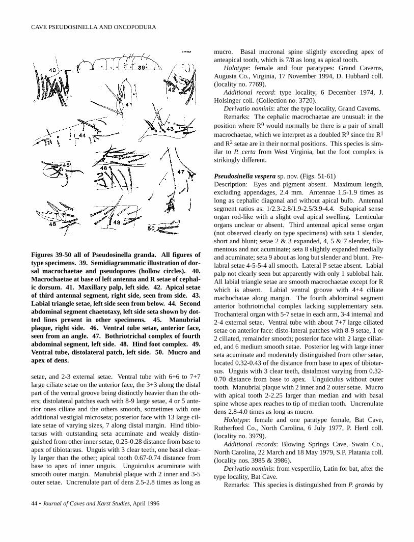
44 • Journal of Caves and Karst Studies, April 1996
Figures 39-50 all of Pseudosinella granda. All figures oftype specimens. 39. Semidiagrammatic illustration of dor-sal macrochaetae and pseudopores (hollow circles). 40.Macrochaetae at base of left antenna and R setae of cephal-ic dorsum. 41. Maxillary palp, left side. 42. Apical setaeof third antennal segment, right side, seen from side. 43.Labial triangle setae, left side seen from below. 44. Secondabdominal segment chaetotaxy, left side seta shown by dot-ted lines present in other specimens. 45. Manubrialplaque, right side. 46. Ventral tube setae, anterior face,seen from an angle. 47. Bothriotrichal complex of fourthabdominal segment, left side. 48. Hind foot complex. 49.Ventral tube, distolateral patch, left side. 50. Mucro andapex of dens.
setae, and 2-3 external setae. Ventral tube with 6+6 to 7+7large ciliate setae on the anterior face, the 3+3 along the distalpart of the ventral groove being distinctly heavier than the oth-ers; distolateral patches each with 8-9 large setae, 4 or 5 ante-rior ones ciliate and the others smooth, sometimes with oneadditional vestigial microseta; posterior face with 13 large cil-iate setae of varying sizes, 7 along distal margin. Hind tibio-tarsus with outstanding seta acuminate and weakly distin-guished from other inner setae, 0.25-0.28 distance from base toapex of tibiotarsus. Unguis with 3 clear teeth, one basal clear-ly larger than the other; apical tooth 0.67-0.74 distance frombase to apex of inner unguis. Unguiculus acuminate withsmooth outer margin. Manubrial plaque with 2 inner and 3-5outer setae. Uncrenulate part of dens 2.5-2.8 times as long as
mucro. Basal mucronal spine slightly exceeding apex ofanteapical tooth, which is 7/8 as long as apical tooth.
Holotype: female and four paratypes: Grand Caverns,Augusta Co., Virginia, 17 November 1994, D. Hubbard coll.(locality no. 7769).
Additional record: type locality, 6 December 1974, J.Holsinger coll. (Collection no. 3720).
Derivatio nominis: after the type locality, Grand Caverns.Remarks: The cephalic macrochaetae are unusual: in the
position where R0 would normally be there is a pair of smallmacrochaetae, which we interpret as a doubled R0 since the R1
and R2 setae are in their normal positions. This species is sim-ilar to P. certa from West Virginia, but the foot complex isstrikingly different.
Pseudosinella vespera sp. nov. (Figs. 51-61)Description: Eyes and pigment absent. Maximum length,excluding appendages, 2.4 mm. Antennae 1.5-1.9 times aslong as cephalic diagonal and without apical bulb. Antennalsegment ratios as: 1/2.3-2.8/1.9-2.5/3.9-4.4. Subapical senseorgan rod-like with a slight oval apical swelling. Lenticularorgans unclear or absent. Third antennal apical sense organ(not observed clearly on type specimens) with seta 1 slender,short and blunt; setae 2 & 3 expanded, 4, 5 & 7 slender, fila-mentous and not acuminate; seta 8 slightly expanded mediallyand acuminate; seta 9 about as long but slender and blunt. Pre-labral setae 4-5-5-4 all smooth. Lateral P setae absent. Labialpalp not clearly seen but apparently with only 1 sublobal hair.All labial triangle setae are smooth macrochaetae except for Rwhich is absent. Labial ventral groove with 4+4 ciliatemachochatae along margin. The fourth abdominal segmentanterior bothriotrichal complex lacking supplementary seta.Trochanteral organ with 5-7 setae in each arm, 3-4 internal and2-4 external setae. Ventral tube with about 7+7 large ciliatedsetae on anterior face: disto-lateral patches with 8-9 setae, 1 or2 ciliated, remainder smooth; posterior face with 2 large ciliat-ed, and 6 medium smooth setae. Posterior leg with large innerseta acuminate and moderately distinguished from other setae,located 0.32-0.43 of the distance from base to apex of tibiotar-sus. Unguis with 3 clear teeth, distalmost varying from 0.32-0.70 distance from base to apex. Unguiculus without outertooth. Manubrial plaque with 2 inner and 2 outer setae. Mucrowith apical tooth 2-2.25 larger than median and with basalspine whose apex reaches to tip of median tooth. Uncrenulatedens 2.8-4.0 times as long as mucro.
Holotype: female and one paratype female, Bat Cave,Rutherford Co., North Carolina, 6 July 1977, P. Hertl coll.(locality no. 3979).
Additional records: Blowing Springs Cave, Swain Co.,North Carolina, 22 March and 18 May 1979, S.P. Platania coll.(locality nos. 3985 & 3986).
Derivatio nominis: from vespertilio, Latin for bat, after thetype locality, Bat Cave.
Remarks: This species is distinguished from P. granda by
CAVE PSEUDOSINELLA AND ONCOPODURA

Journal of Caves and Karst Studies, April 1996 • 45
Figures 51-61 of Pseudosinella vespera. 51.Semidiagrammatic illustration of dorsal macrochaetae andpseudopores (hollow circles). 52. Apical region of secondantennal segment, type specimen. 53. Apical setae of thirdantennal segment, right side seen from above, specimenfrom Swain Co. 54. Labial triangle setae, right side, typespecimen. 55. Ventral tube setae, distolateral patch, rightside, specimen from Swain Co. 56. Ventral tube, posteriorface, seen from a posterior angle, type specimen. 57.Dorsal chaetotaxy, second abdominal segment, right side,type specimen. 58. Outer bothriotrichal complex, thirdabdominal segment, specimen from Swain Co. 59. Hindfoot complex type specimen. 60. Hind unguis, specimenfrom Swain Co. 61. Apex of dens and mucro, specimenfrom Swain Co.
the smooth labial triangle setae. It is separated from flatua bythe presence of posterior macrochaetae on thoracic segments 2& 3. It is distinguished from maritima (Bagnall, 1941) by theacuminate tibiotarsal outstanding seta as well as habitat. It dif-fers from the European styriaca (Neuherz & Nosek, 1975) inthe absence of the P1 seta on the fourth abdominal segment,claw shape, and structure of setae 2 & 3 on the third antennalsegment apex. It is difficult to analyze the insufficientlydescribed New Zealand species insoloculata (Salmon, 1941);however vespera appears to differ in claw structure and a gen-erally longer antenna. It appears to be most similar to theEuropean cave species virei (Absolon, 1901) but differs inlacking the second abdominal segment p seta and the 4th
abdominal segment P1 seta, as well as other minor features.Since both species are troglomorphic, conspecificity seemshighly improbable.
The present collections are two populations differing strik-ingly in their level of troglomorphy. The Swain Co. specimensare much more troglomorphic than the Rutherford Co. ones.The fact that the cephalic chaetotaxy, thoracic macrochaetae,and other chaetotaxic features are the same in both populationsindicates that they can be considered the same species. Furthercollections may well show intermediate conditions in cavesfound between these two areas.
Pseudosinella extra sp. nov. (Figs. 121-131)Description: White without eyes or traces of pigment.Maximum length, omitting appendages, 1.5 mm. Antennae1.38-1.5 times as long as cephalic diagonal and lacking apicalbulb. Antennal segment ratios 1/2.0-2.4/1.30-1.65/3.0-3.4.Subapical organ small and rod-like. Lenticular organs weakly
Figures 121-131 all of Pseudosinella extra. All figures oftype specimens. 121. Semidiagrammatic illustration ofdorsal macrochaetae and pseudopores (hollow circles).122. Detail of anterior dorsal cephalic chaetotaxy of leftside. 123. Labial triangle setae. 124. Lateral chaetotaxyof second abdominal segment, left side. 125. Ventral tube,anterior face. 126. Posterior face of ventral tube. 127.Ventral tube, left side, distolateral patch. 128. Fourthabdominal segment bothriotrichal complex, left side. 129.Fore foot complex. 130. Trochanteral organ. 131. Mucroand ends of dens.
CHRISTIANSEN AND BELLINGER

46 • Journal of Caves and Karst Studies, April 1996
developed between third and fourth and second and third seg-ments. Third antennal apical setae 2 & 3 small and peg-like;setae 1 & 4 curved, slender, and acuminate and about 3 timesas long as setae 2 & 3. Seta 5 very small and peg-like; seta 8curved, blunt and slightly basally enlarged; setae 6 & 7 slendercurved and slightly truncate. Prelabral setae 4-5-5-4 allsmooth. Labial palp with three sublobal hairs. Labial trianglewith seta M1 and r ciliate; remainder smooth. Marginalmacrochaetae along cephalic labial ventral groove 4+4, all cil-iate. Second abdominal segment with P seta relatively long butnot clearly ciliate. Fourth abdominal segment with anteriorbothriotrichal complex having a supplementary seta.Trochanteral organ with five setae in arms and one externalseta. Ventral tube with 7+7-8+8 large ciliate setae on anteriorface and 10-12 on posterior face; distolateral patches with 8setae, 3 smooth and remainder ciliate. Hind tibiotarsus withclearly differentiated inner large seta, only slightly longerother large setae but cylindrical and apically blunt or truncate,situated 0.32—0.37 distance from base to apex of tibiotarsus.Unguis with 3 clear teeth; basal pair large with one much larg-er than other; distal tooth prominent and 0.4-0.5 distance frombase to apex of inner unguis. Unguiculus acuminate with outermargin serrate. Tenent hairs acuminate and apically curved.Manubrial plaque with 2 inner and 2 outer setae. Uncrenulatedens 2.1-2.8 times as long as mucro. Apical mucronal toothabout 1 1/2 times as long as basal with basal spine not quitereaching apex of subapical tooth.
Holotype: female and 1 paratype: Jack’s Cave, Scott Co.,Virginia, 14 June 1995, on debris, D. Hubbard coll. (localityno. 7854).
Other locality: Basil Duncan Cave, Scott Co., Virginia, 2March 1995, D. Hubbard coll. (locality no. 7807).
Derivatio nominis: named because the first specimens wereseen after the original manuscript had been completed.
Remarks: This species is quite close to P. vespera fromNorth Carolina but the ciliate r seta on the labial triangle andthe presence of a p seta on the second abdominal segment, aswell as the different thoracic macrochaetae, readily serve toseparate the two species.
Pseudosinella bona sp. nov. (Figs. 132-142)Description: White except for eyepatches. Eyes 1+1 or 2+2but generally without clear cornea visible. Maximum length,omitting appendages, 2.7 mm.
Antennae 1.5-1.8 times as long as cephalic diagonal andlacking apical bulb. Antennal segment ratios 1/2.2-2.7/1.85-2.25/3.1-3.35. Subapical organ rod-like, truncate, and with aslight taper. Lenticular organs well developed, one betweensecond and third segments and 1 or 2 between third and fourthsegments. Third antennal apical setae seen clearly on only onetype specimen. Setae 1, 4, 6 & 9 are acuminate slender andlonger than 2 & 3 which are swollen; setae 5 & 7 are short andpeg-like; seta 8 is acuminate and slightly basally swollen sup-plementary seta between setae 5 & 8 seen in the type is absent
Figures 132-142 all of Pseudosinella bona. All figures oftype specimens. 132. Semidiagrammatic illustration ofdorsal macrochaetae and pseudopores (hollow circles).133. Apex of third antennal segment, type specimen. 134.Detail of anterior, dorsal cephalic chaetotaxy. 135. Labialtriangle setae. 136. Distolateral ventral tube setae, leftside. 137. Chaetotaxy of second abdominal segment, rightside. 138. Fore foot complex. 139. Manubrial plaque.140. Third abdominal lateral bothriotrichal complex, rightside. 141. Fourth abdominal segment bothriotrichal com-plex, right side. 142. Mucro and ends of dens.
in the Washington Co. specimens. Prelabral setae 4-5-5-4;posterior most row ciliate and remainder smooth. Labial palpwith three sublobal hairs. Labial triangle with seta r and rarelyseta M1 ciliate; remainder smooth. With 4+4 ciliate, marginalmacrochaetae along labial ventral groove. Second abdominalsegment with P seta relatively long but not clearly ciliate.Fourth abdominal segment with anterior bothriotrichal com-plex having a supplementary seta. Trochanteral organ with 8-15 setae in arms, 9-20 internal and 1-3 external setae. Ventraltube with 10+10 to 14+14 large ciliate setae on anterior faceand 2 ciliate macrochaetae and 14-20 mesochaetae on posteri-or face; distolateral patches with 9-14 setae, anterior 4-7 cili-ate and remainder smooth. Hind tibiotarsus with clearly dif-ferentiated acuminate inner large seta, only slightly longerother large setae, situated 0.22-0.41 distance from base to apexof tibiotarsus. Unguis with 3 clear teeth; basal pair moderate-ly large with one only slightly larger than other; distal toothprominent and 0.52-0.58 distance from base to apex of inner
CAVE PSEUDOSINELLA AND ONCOPODURA

Journal of Caves and Karst Studies, April 1996 • 47
unguis. Unguiculus acuminate with outer margin smooth.Tenent hairs acuminate. Manubrial plaque with 2 inner and 4-7 outer setae. Uncrenulate dens 2.3-2.5 times as long asmucro. Mucronal apical tooth slightly longer than subapicalwith basal spine slightly exceeding apex of subapical tooth.
Holotype: female and 10 paratypes: Goodwin’s Cave,Roanoke Co., Virginia, 4 June 1995, on debris, D. Hubbardcoll. (locality no. 7845), same cave Big Formation Room, 1August 1973 (locality no. 4319).
Other locality: Lowe’s Cave, Washington Co., Virginia, 7September 1979, Holsinger et al. coll. (locality no. 4319).
Derivatio nominis: Latin bonum = good, named after typelocality cave.
Remarks: This striking species was first sent to the seniorauthor in 1974 by Ferguson; however the two specimens werenot adequate for a description. An additional 2 poor specimenswere sent by John Holsinger in 1979 from Washington Co.When David Hubbard started making extensive collections ofCollembola in Virginia caves we suggested he return toGoodwin’s Cave to see if the species could be rediscovered.He did so and sent a fine series of specimens.
The species is unusual in always having clear eye pigmentbut in only one specimen could we see an obvious indicationof a cornea. It is close to the Virginia species P. granda but isclearly distinguishable on the basis of the eye pigment and thelarge ciliate r seta in the labial triangle. It also resembles P.gisini but can easily be separated on the claw shape. One spec-imen from Washington Co. has seta M2 ciliate on one side butall populations show specimens with the typical labial chaeto-taxy shown in Table 1.
Pseudosinella gisiniThis species is abundant in the caves of Pocahontas,
Greenbrier, and Monroe counties, West Virginia. It also hasone questionable record from Mercer county. More recently ithas been collected from two caves in Rutherford CountiesNorth Carolina and one cave in Lee County Virginia. The dis-covery of these two amazingly disjunct populations necessitat-ed a thorough reexamination of the species. This led to the dis-covery that Pseudosinella gisini gisini has a very unusualstructure of the third antennal segment apical setae. This is theexistence of a supplementary seta which we call seta 7a (seeFig. 73). Both the disjunct populations lack this seta and havethird antennal apical setae more typical of the genus (see Figs.74 & 79). All subspecies of P. gisini share an unusually longseta 1. The gisini specimens vary in the labial ventral groovechaetotaxy from all smooth to one pair smooth and the othersciliate; however the majority have the 3 anterior setae smoothand the other pair ciliate. All specimens of the disjunct popu-lations have all 4+4 setae ciliate. The two disjunct populationsare sufficiently similar to the West Virginia ones that we feelspecific separation is unwarranted; however, they are suffi-ciently distinct that we feel subspecific status should be given.The strong possibility that further intermediates may be uncov-
ered with additional cave exploration reinforces the adoptionof subspecific status. We name them and give their character-istics in Table 3.
Descriptions:Pseudosinella gisini virginia subspecies nov. (Figs. 74-78)
Maximum length 2 mm. Body and appendages white.Blue pigment limited to region of eyes, and a scattering ofgranules over remainder of dorsum of head. Eyes generally2+2 but a few specimens have these very obscure and mayhave only 1+1 eye. One specimen has distinctly darker pig-mentation on anterior half of the dorsum of head. Tenent hairoccasionally acuminate but generally weakly truncate.Unguiculus occasionally with very slight inner swelling on onepair of legs but generally without such. Ventral tube featuresas shown in Figure 78 and Table 3. Other features as in P. gisi-ni gisini.
Figures 73-84 of Pseudosinella gisini. 73. Apical setae ofapex of third segment of gisini gisini. Large setae with onlybases shown. Figures 74-78 all of gisini virginia. 74.Apical third antennal setae as in Figure 73. 75. Labial tri-angle setae, right side. 76-77. Eyepatches, left side in twodifferent specimens. 78. Setae of distolateral patch of ven-tral tube. Figures 79-84 of gisini carolina. 79. Apical setaeof third antennal segment, as in Figure 73. 80-81. Labialtriangle setae of two specimens from the same cave. 82-83.Eyepatch regions of same two specimens. 84. Setae of dis-tolateral patch of ventral tube.
CHRISTIANSEN AND BELLINGER

48 • Journal of Caves and Karst Studies, April 1996
Holtype: female and 6 female paratypes, Spangler Cave,Lee Co., Virginia, 29 March 1995, D. Hubbard coll. (locality n.7815).
Pseudosinella gisini carolina subspecies nov. (Figs. 79-84)Maximum length 3 mm. Pigment varying from complete-
ly lacking or blue, limited to eye regions to dark around eyesand with a wash of granules over remainder of the dorsum ofhead and body. Eyes 1+1 to lacking. Tenent hairs generallyacuminate but occasionally truncate or weakly clavate.Unguiculus with or without slight basal swelling. Ventral tubechaetotaxy as shown in Table 3 and Figures 84. Other featuresas in P. gisini gisini.
Holotype: female and 4 female paratypes, McGrathFissure, Rutherford Co., North Carolina, 25 November 1994,Cato & Christ Holler colls. (locality no. 7774).
Other collection: Rumbling Bald Cave, Lake Lure,Rutherford Co., North Carolina, 2 July 1977, P. Hertl coll.(locality no. 3973).
The nature of this species and its distribution poses apresently unsolvable puzzle. The species is large (adult sizemostly 3-5 mm) and readily recognizable. Extensive collec-tions have been made in caves between the two disjunct popu-lations and the West Virginia sites. It is very unlikely that itoccurs in more than a few intermediate caves. Given the exten-sive surface collections done in this region it is highly unlike-ly that it occurs outside of caves. This would indicate a longoccupation in caves and a troglobite nature. On the other hand,the fact that the species is weakly troglomorphic in a numberof features (clavate or truncate tenent hairs often present, pig-ment and eyes present) plus the widely disjunct distribution
Table 3. Distinguishing Characteristics of Subspecies of Pseudosinella gisini.
would appear to point to a troglophile species with relativelyrecent invasion of caves.
ONCOPODURA
The other genus we shall deal with in this paper isOncopodura (Carl & Lebedinsky, 1905).
This genus and the family Oncopoduridae have beenreviewed by a number of authors, including Bonet (1943), andSzeptycki (1977a, b); most recently Deharveng (1988) hasreviewed the literature, established species groups ofOncopodura, and proposed taxonomic use of new characters.Christiansen and Reddell (1986) described two new speciesfrom Mexican caves and discussed the Mexican fauna.
We have discovered a number of new cave and edaphicspecies in the course of our work updating the Collembola ofNorth America. Most species of the genus appear to be troglo-bitic and this is true of the new species we have discoveredfrom North America. Several of these species are too poorlyrepresented by specimens to merit description. Table 4 indi-cates some of the diagnostic characteristics of these species, aswell as all described cave species of the genus so far knownfrom North America.
The genus is remarkably uncommon in collections, andmost species we have seen are represented by very few speci-mens. Because of the extreme fragility of specimens and thedeciduous nature of the diagnostic scales and spines, many areunsuitable for description. In the case of O. fenestra, in manyhundreds of samples from the caves of Travis and Williamsoncounties in Texas only 5 specimens have been recovered, withno more than two from any one cave. Since the habitat inwhich they were found does not appear exceptional in any way,
CAVE PSEUDOSINELLA AND ONCOPODURA

Journal of Caves and Karst Studies, April 1996 • 49
Table 4. Characteristics of US Cave Oncopodura.
this rarity is difficult to explain. The only two large series ofOncopodura we have seen were from rocks isolated in mid-stream, suggesting that individuals are extremely solitary andaggregate only when compelled to do so by rising water.
Both Szeptycki (1977a,b) and Deharveng (1988) havegood general discussions of the taxonomic features of thegroup. In general we follow the model of Deharveng (1988) inthe following descriptions. Among the characters he used arethe types of antennal setae; we find some of these to be gener-ally useful in descriptions, and illustrate a number of types(from his description of O. pelissei) which can be recognizedin our species.
Oncopodura fenestra sp. nov. (Figs. 86-97)Description: Habitus: typical of genus (see Fig. 86).Maximum length 2.0 mm. Color white without trace of pig-ment. Antennae 1.5-1.8 times cephalic diagonal, without api-cal bulb or scales. Fourth segment with subapical trio notclearly separated from other setae. Two apically sharplycurved acuminate setae and one more basal short one, apicallyacuminate and basally expanded; a similar seta may be presentnear the second type 8 seta; six type 8 setae, one basal, a sec-ond and third close to each other, and three additional, widelyspaced, all in a line; the basalmost of these usually has a welldeveloped type 11 seta next to it; almost all other setae are oftype 1A. Third segment with 9-14 apical and subapical type 8setae; ventral surface with a number of very long slender setae;
other setae are thick type 1A. Second segment with 12-15 type8 setae; others are type 1A, of varying thickness and length.First antennal segment with one small type 8 seta, two ventralmicrosetae, and type 1A setae of varying sizes. PAO absent.Unguis moderately broad, untoothed, and with a prominentinner lamina, slightly shorter than the unguiculus; outer pre-tarsal seta about 1/10 length of inner unguis; inner seta minuteand difficult to observe. Unguiculus acuminate, without clearbasal swelling. Apically expanded seta of mesotibiotarsusclavate; most other tibiotarsal setae are large, acuminate, andextremely finely ciliate. Tenent hair slender and acuminate.Ventral tube without prominent papillae; with 4+4 type 1Asetae on distolateral lobes. Tenaculum with 44 teeth and largestout acuminate ciliate seta on the corpus. Manubrial chaeto-taxy not intact on any specimen seen but there are many (about25+25) dorsal setae, at least 15 being of type 14 and at least 5of type 4. Dens distoventrally with 4 large type 1 setae; exter-nal face basally with one extremely finely ciliate, acuminatemesochaeta, and distally with one very large curved spine hav-ing many minute scales on its median face; dorsally not intacton any specimen, but apparently with 5 large type 14 setae (2basal, 1 medial, 2 distal) plus one medial and 2 basal smalltype 1A setae; internally with 3 curved, deeply serrate spines,increasing in size distally. Mucro with 4 teeth and a largescale. Fourth abdominal segment with median row of 4+4 and1+1 posterolateral macrochaetae, and 10+10 microchaetae.Fifth abdominal segment with 4+4 posterolateral
CHRISTIANSEN AND BELLINGER

50 • Journal of Caves and Karst Studies, April 1996
Type Description (see Fig. 85)1A. Normal medium to large smooth setae, gradually
tapering to point.1B. Similar to 1A. but finely ciliate.2. Normal setae swollen at the base, with or without a
slender apical extension.4. Setae similar to type 1A but prominently at right
angles to body or antennal surface.6. Setae similar to type 1A but slightly truncate.7. Short blunt fusiform setae.8. Large blunt flattened fusiform setae.9. Long blunt subcylindrical setae, often thinwalled.13. Setae similar to type 8 but with clear striations at right
angles to central axis.14. Marochaetae, multilaterally ciliate.
Figure 85 semidiagrammatic illustration of antennal setatypes of Oncopodura modified from Deharveng (1988), seetext.
macrochaetae in rows, 3+3 small type 1A setae anteriorly, and5+5 microchaetae in posterior half. Sixth segment with 2 rowsof macrochaetae, 4 anterior and 5 in posterior row.
Holotype: Cueva de la Ventana, Travis Co., Texas, 10February 1993, M. Wharton coll. (locality no. 7564).
Other records: Maple Rune Cave, Travis Co., Texas, 31January 1991, J. Reddell coll. (locality no. 7332). Inner SpaceCaverns, Williamson Co., Texas, 6 May 1989, W. Elliott coll.(locality no. 7125). Sting Cave, Williamson Co., Texas, 7November 1994, Reddell & Reyes colls. (locality no. 7824).
Derivatio nominis: Latin fenestra, window, after the typelocality cave (ventana = window).
Remarks: This unusual species was originally identified asO. prietoi (Bonet, 1943), but on closer examination was seen
Figures 86-97 of Oncopodura fenestra. 86. Habitus, typespecimen. 87. Right fourth antennal segment, type speci-men. 88. Base of fourth antennal segment, specimen fromMaple Run Cave, Travis Co. 89. Apex of third antennalsegment, type specimen. 90. Apex of second antennal seg-ment, type specimen. 91. Outer face of mid tibiotarsus,type specimen. 92. Hind foot complex from side, type spec-imen. 93. Mid unguis inner view, same specimen. 94.Inner face, right dens, type specimen. 95. Outer face, rightdens and mucro, same specimen. 96. Enlarged view of dis-tal outer spine, specimen from Sting Cave, Williamson Co.97. Dorsum of manubrium, type specimen.
to be very different in antennal chaetotaxy and different inother minor features. The presence of 6 type 8 setae on thefourth antennal segment distinguishes it from all other NewWorld members of the genus; in this respect it resembles O.lebretoni (Deharveng, 1988), a French troglobite which is oth-erwise very different. The type 11 seta on the base of thefourth antennal segment is absent in the holotype but present inthe specimens from Maple Run Cave and Sting Cave. Thespecimens from Inner Space Cave, Williamson Co. do notshow the antennal structure clearly, but are otherwise similar tothe type. O. fenestra would belong in Deharveng’s group 2.2.
We have seen only 5 specimens form 4 localities amonghundreds of samples from Texas caves, implying a remarkablerarity.
CAVE PSEUDOSINELLA AND ONCOPODURA

Journal of Caves and Karst Studies, April 1996 • 51
Oncopodura hubbardi sp. nov. (Figs. 98-107)Description: Habitus: typical of genus (see Fig. 98), exceptthat the suture between the third and fourth abdominal segmentis often obsolete so that the two appear to be one segment.Maximum length 1.2 mm. Color white (yellowish in alcohol),without trace of pigment. Antennae 1.14-1.38 times as long ascephalic diagonal, without apical bulb. Fourth antennal seg-ment with one type 6 and two type 9 setae in subapical trio: onebasal and a row of 4 distal setae of type 8; other setae of type1A or 4. Third antennal segment with 2 apical setae of type 8and a medial one, (sometimes absent?); other setae of type 1A.Second antennal segment with 2 setae of type 8 in medial file;other setae of type 1A or intermediate between types 1A and 2.First antennal segment with distal ring of 9 setae and a few oth-ers, of type 2 or intermediate between types 2 and 1A. PAOdistinct, in shallow groove, with 5-6 radiating lobes of unequallengths. Unguis very slender, untoothed, and with pronouncedslender lamina about 3/4 as long as unguiculus; pretarsal setaevery small, the inner one often difficult to see and only 0.03times length of inner unguis. Unguiculus basally stronglyswollen, between 1/2 and 2/3 as long as inner unguis. Apicallyexpanded mesotibiotarsal seta with flattened ovoid shape andpronounced ridge along one margin; 3 basal tibiotarsal setaefinely ciliate, remainder smooth. Ventral tube with 4+4 largesmooth setae on distolateral lobes, and 2 small curved bluntsetae, often difficult to observe, in deep groove behind posteri-or lateral setae; pair of large apically indented papillae anteri-orly at end of the ventral groove, and smaller pair, not indent-ed, in equivalent position on posterior face. Tenaculum with4+4 teeth and single small blunt seta on basal part of the cor-pus. Dorsal surface of manubrium not clearly seen, but appar-ently with 12+12 setae, 4+4 (5+5) of type 4 and remainder oftype 14. Dens ventrodistally with 3 stout type 1A setae; exter-nal face with a small slender straight spine basally and a verylarge curved distal spine with a few very fine inner serrations;dorsally with 3 basal and 2 distal type 14 setae, and two basaland one medial smooth type 3 setae; inner face with one mod-erate distal curved spine having one (rarely two) large serra-tions. Mucro with 4 teeth and large basal scale. Fourth abdom-inal segment with medial row of 3+3 macrochaetae but other-wise not clearly seen. Fifth segment with 3+3 anterior type 1Asetae and 4+4 lateral type 14 macrochaetae. Sixth segment notclearly seen, but apparently with 12 posterior macrochaetae in3 rows of 4, 3, and 5 setae from front to back.
Holotype: and 14 paratypes: Reasor’s Cave, Lee Co.,Virginia on rock near stream, 13 July 1994, D. Hubbard coll.(locality no. 7739).
Other localities: Burton Cave, Lee Co., Virginia, 6 June1994, D. Hubbard coll. (locality no. 7710); Spangler Cave, LeeCo., 29 March 1995, D. Hubbard coll. (locality no. 7815).
Derivatio nominis: after David Hubbard who collected thisspecies and whose other incredible collections have beeninvaluable for this as well as other studies.
Remarks: This is the only Nearctic species combining the
Figures 98-107 of Oncopodura hubbardi. All figures oftype specimens. 98. Habitus. 99. Dorsal surface of fourthantennal segment. 100. Dorsal surface of second and thirdantennal segments, same specimen. 101A-B. P.A.O. of twospecimens. 102. Inner face of mid tibiotarsus. 103. Forefoot complex, seen from side. 104. Ventral tube. 105.Dorsal surface of manubrium. 106. Inner face of left dens,A. distal spine from different angle. 107. Outer face of leftdens.
features of a dental scale, ungual lamella, and lobed PAO. Itwould fall in Deharveng’s (1988) group 2.2.
Oncopodura mala sp. nov. (Figs. 108-120)Description: Habitus: typical of genus (see Fig. 108).Maximum length 1.3 mm. White without trace of pigment.Antennae 0.9-1.04 times as long as cephalic diagonal, withoutscales. Fourth segment without apical bulb, but with a conicalprojection; subapical trio with sharply curved type 6 setae andone straight thick stout acuminate seta; a distal file of 4 type 8setae; other setae of type 1A. Third antennal segment with onetype 13 seta, one distal and one smaller subapical seta of type8, about 15 dorsal setae intermediate between types 2 and 1A;ventral surface with setae of types 1A and 3. Second antennalsegment with one apical and one subapical seta of type 8 , oneshort, spine-like apical seta, and remaining dorsal setae inter-mediate between types 2 and 1A; ventral surface with setae oftypes 1A and 3. First antennal segment dorsally with type 2setae in apical row plus one basal; ventral surface not seen
CHRISTIANSEN AND BELLINGER
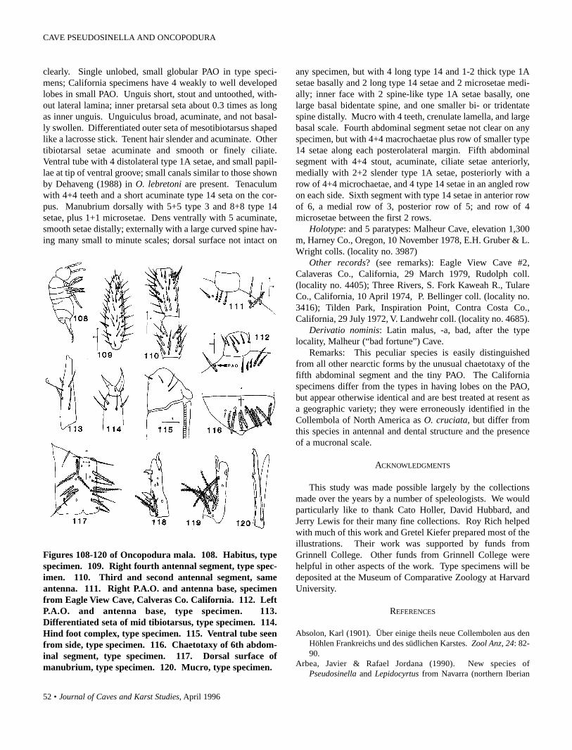
52 • Journal of Caves and Karst Studies, April 1996
Figures 108-120 of Oncopodura mala. 108. Habitus, typespecimen. 109. Right fourth antennal segment, type spec-imen. 110. Third and second antennal segment, sameantenna. 111. Right P.A.O. and antenna base, specimenfrom Eagle View Cave, Calveras Co. California. 112. LeftP.A.O. and antenna base, type specimen. 113.Differentiated seta of mid tibiotarsus, type specimen. 114.Hind foot complex, type specimen. 115. Ventral tube seenfrom side, type specimen. 116. Chaetotaxy of 6th abdom-inal segment, type specimen. 117. Dorsal surface ofmanubrium, type specimen. 120. Mucro, type specimen.
clearly. Single unlobed, small globular PAO in type speci-mens; California specimens have 4 weakly to well developedlobes in small PAO. Unguis short, stout and untoothed, with-out lateral lamina; inner pretarsal seta about 0.3 times as longas inner unguis. Unguiculus broad, acuminate, and not basal-ly swollen. Differentiated outer seta of mesotibiotarsus shapedlike a lacrosse stick. Tenent hair slender and acuminate. Othertibiotarsal setae acuminate and smooth or finely ciliate.Ventral tube with 4 distolateral type 1A setae, and small papil-lae at tip of ventral groove; small canals similar to those shownby Dehaveng (1988) in O. lebretoni are present. Tenaculumwith 4+4 teeth and a short acuminate type 14 seta on the cor-pus. Manubrium dorsally with 5+5 type 3 and 8+8 type 14setae, plus 1+1 microsetae. Dens ventrally with 5 acuminate,smooth setae distally; externally with a large curved spine hav-ing many small to minute scales; dorsal surface not intact on
any specimen, but with 4 long type 14 and 1-2 thick type 1Asetae basally and 2 long type 14 setae and 2 microsetae medi-ally; inner face with 2 spine-like type 1A setae basally, onelarge basal bidentate spine, and one smaller bi- or tridentatespine distally. Mucro with 4 teeth, crenulate lamella, and largebasal scale. Fourth abdominal segment setae not clear on anyspecimen, but with 4+4 macrochaetae plus row of smaller type14 setae along each posterolateral margin. Fifth abdominalsegment with 4+4 stout, acuminate, ciliate setae anteriorly,medially with 2+2 slender type 1A setae, posteriorly with arow of 4+4 microchaetae, and 4 type 14 setae in an angled rowon each side. Sixth segment with type 14 setae in anterior rowof 6, a medial row of 3, posterior row of 5; and row of 4microsetae between the first 2 rows.
Holotype: and 5 paratypes: Malheur Cave, elevation 1,300m, Harney Co., Oregon, 10 November 1978, E.H. Gruber & L.Wright colls. (locality no. 3987)
Other records? (see remarks): Eagle View Cave #2,Calaveras Co., California, 29 March 1979, Rudolph coll.(locality no. 4405); Three Rivers, S. Fork Kaweah R., TulareCo., California, 10 April 1974, P. Bellinger coll. (locality no.3416); Tilden Park, Inspiration Point, Contra Costa Co.,California, 29 July 1972, V. Landwehr coll. (locality no. 4685).
Derivatio nominis: Latin malus, -a, bad, after the typelocality, Malheur (“bad fortune”) Cave.
Remarks: This peculiar species is easily distinguishedfrom all other nearctic forms by the unusual chaetotaxy of thefifth abdominal segment and the tiny PAO. The Californiaspecimens differ from the types in having lobes on the PAO,but appear otherwise identical and are best treated at resent asa geographic variety; they were erroneously identified in theCollembola of North America as O. cruciata, but differ fromthis species in antennal and dental structure and the presenceof a mucronal scale.
ACKNOWLEDGMENTS
This study was made possible largely by the collectionsmade over the years by a number of speleologists. We wouldparticularly like to thank Cato Holler, David Hubbard, andJerry Lewis for their many fine collections. Roy Rich helpedwith much of this work and Gretel Kiefer prepared most of theillustrations. Their work was supported by funds fromGrinnell College. Other funds from Grinnell College werehelpful in other aspects of the work. Type specimens will bedeposited at the Museum of Comparative Zoology at HarvardUniversity.
REFERENCES
Absolon, Karl (1901). Über einige theils neue Collembolen aus denHöhlen Frankreichs und des südlichen Karstes. Zool Anz, 24: 82-90.
Arbea, Javier & Rafael Jordana (1990). New species ofPseudosinella and Lepidocyrtus from Navarra (northern Iberian
CAVE PSEUDOSINELLA AND ONCOPODURA

Journal of Caves and Karst Studies, April 1996 • 53
Peninsula) (Insecta: Collembola: Entomobridae). Spixiana, 13:25-31.
Bagnall, Richard (1939). Notes on British Collembola. [V]: Ent.monthly Mag., 75: 188-200.
Bagnall, Richard (1941). Notes on British Collembola. [VIII]: Ent.monthly Mag 77: 217-226.
Bonet, Federico (1943). Sobre la clasificación de los Oncopoduridae(Collembola), con descripción de especies nuevas. An. Esc. nac.Cienc. biol., 3: 127-153.
Börner, Carl (1901). Neue Collembolenformen und zur Nomenclaturder Collembola Lubbock. Zool. Anz., 24: 696-712.
Carl, J. & Lebidinsky, J. (1905). Matrialen zur Höhlen Fauna derKrim. Zool. Anz., 28: 562-565.
Chen Jian-Xiu & Christiansen, Kenneth (1993). The genus Sinellawith special reference to Sinella s.s. (Collembola: Entomobridae)of China. Oriental Ins., 27: 1-54.
Christiansen, Kenneth (1961). The genus Pseudosinella (Collembola,Entomobryidae) in caves of the United States. Psyche 67: 1-25.
Christiansen, Kenneth & Bellinger, Peter (1980-81). The Collembolaof North America north of the Rio Grande. Grinnell, Iowa:Grinnell College.
Christiansen, Kenneth; da Gama, Manuela, & Bellinger, Peter (1983).A catalogue of the species of the genus Pseudosinella. Ciênc.biol. Syst. Ecol., 5: 13-31.
Christiansen, Kenneth & Reddell, James (1986). The caveCollembola of Mexico. Speleol. Monogr. Texas mem. Mus. 1:126-164.
Christiansen, Kenneth; Bellinger, Peter, & da Gama, Manuela (1990).Computer assisted Identification of Specimens of Pseudosinella(Collembola Entomobryidae). Rev. Ecol. Biol. Sol. 27: 231-246.
Deharveng, Louis (1988). Collemboles cavernicoles VIII.Contribution à l’étude des Oncopoduridae. Bull. Soc. ent. Fr., 92:133-147.
Folsom, Justus (1924). New species of Collembola from New YorkState. Amer. Mus. Novit., 198: 1-12.
da Gama, Manuela (1984). Phylogénie des espèces européennes dePseudosinella (Collembola: Entomobryidae). Annls. Soc. r. zool.Belg., 114: 59-70.
Gisin, Hermann (1967). Espèces nouvelles et lignées évolutives dePseudosinella endogés (Collembola). Mems. Estud. Mus. Zool.Univ. Coimbra, 301: 1-21.
de Izarra, Dora (1965). Fauna colembologica de Sierra de la Ventana(Provincia de Buenos Aires, Argentina). Physis, B. Aires, 25: 263-276.
Loksa, Imre (1961). Ökologisch-faunistische Untersuchungen in derFreiheitshöhle bei Égerszög. Acta zool. hung., 7: 219-230.
Mari-Mutt, Jose (1986). Puerto Rican soecies of Lepidocyrtus andPseudosinella. Caribi. Jour. Sci., 22: 1-48.
Mills, Harlow (1932). New and rare North American Collembola.Iowa St. Coll. J. Sci., 6: 263-276.
Neuherz, Heinz & Nosek, Josef (1975). Pseudosinella styriaca sp. n.(Collembola: Entomobryidae), a new collembolan species fromthe Styrian cave “Raudner-Höhle” (Austria). Int. J. Speleol., 7:399-402.
Rusek, Josef (1971). Zweiter Beitrag zur Kenntnis der Collembola(Apterygota) Chinas. Acta ent. bohemoslovaca, 68: 108-137.
Rusek, Josef (1981). Some Collembola from Iraq. Vestn. cesk. Spol.zool., 45: 63-80.
Salmon, John (1941). The collembolan fauna of New Zealand,including a discussion of its distribution and affinities. Trans. R.Soc. New Zealand, 70: 282-431.
Stach, Jan (1929). Verzeichnis der Apterygogenea Ungarns. Annlshist.-nat. Mus. natn. hung., 26: 269-312.
Stach, Jan (1960). Materialien zur Kenntnis der CollembolenfaunaAfghanistans. Acta zool. cracov., 5: 507-581.
Szeptycki, Andrzej (1977a). Morpho-systematic studies onCollembola. V. The Body chaetotaxy of the genera OncopoduraCarl et Lebedinsky, 1905 and Harlomillsia Bonet, 1944(Oncopoduridae). Revue Ecol. Biol. Sol., 14: 199-209.
Szeptycki, Andrzej (1977b). North Korean Collembola. II. Thegenus Oncopodura Carl et Lebedinsky, 1905 (Oncopoduridae).Acta zool. cracav., 22: 45-54.
CHRISTIANSEN AND BELLINGER

54 • Journal of Caves and Karst Studies, April 1996
WHAT ARE “ANTHODITES”?—CONTINUEDDONALD G. DAVIS
441 S. Kearney St., Denver, CO 80224-1237
Having considered William White’s (1995) response to mytaxonomic challenge to his usage of “anthodite”, based on thatof Hill & Forti (1986), I feel that further discussion is calledfor.
The central problem, which is not resolved by Dr. White’sresponse, is that the name “anthodite” is being applied to twoseparate speleothem forms that are distinct in both morpholo-gy and growth mechanism. This, it seems to me, is not tolera-ble under any system of nomenclature. Nor is the question astrivially academic as might be supposed; such imprecision indefinitions has ill effects on the ongoing practice of geologicinventory recording in caves (Bergthold, 1995).
Dr. White’s point that most speleothem names were definedby laymen, and are often imprecise, is well taken. However, inthe case of anthodites, we have a reasonably informative typedescription in Henderson’s paper of 1949, whose text and illus-trations show clearly that anthodites are quill-like growths hav-ing central canals. There is no indication that the name wasintended to cover acicular aragonite without central canals,which had been called frostwork since the 1890s.
Dr. White disagrees with my suggestion that anthodites area subclass, or “style,” of helictite. Because of the confusionthat has arisen from the arbitrary changes in the usage of“anthodite,” I may need to clarify my suggestion: I suggest thatanthodites as originally defined at Skyline Caverns may be astyle of helictite. I do not suggest that “anthodites” in thesense of frostwork are helictites. (The need to make this clar-ification illustrates the problem!)
Dr. White rejects the original anthodites as falling underhelictites. As part of his basis for this, he states that helictites“are composed of calcite.” This surprised me, as speleothemtypes are not ordinarily defined as restricted to a single com-position; flowstone, dripstone, moonmilk, etc., may be com-posed of any of a number of minerals. Regarding helictites inparticular, the literature has references to non-calcite exam-ples—e.g., helictites of marcasite, galena and sphalerite (Peck,1979,). Hill and Forti also index helictites of a dozen othercompositions—even lava—and refer explicitly to “aragonitehelictites,” under which they categorize the beaded growths ofCave of the Winds, Colorado (which resemble the EndlessCaverns anthodites more than they resemble frostwork).
However, if calcite produces morphology that is most char-acteristic of the “helictite” concept, this suggests one possibleresolution of our problem: retain the word “anthodite,” butrestrict its use to non-gravitogenic, helictite-like speleothemshaving central canals, and composed of—or originating as—aragonite; i.e., those which might otherwise be thought of asaragonite helictites. This would be consistent with the originalanthodite definition, but would exclude frostwork and its vari-
ants from falling under anthodites. In this scheme, aragonitespeleothems would fall into two general classes: anthodites,for those having internal canals; and frostwork and its elabora-tions such as “aragonite bushes,” for the acicular forms.
The above solution, however, makes the terms “anthodite”and “aragonite helictite” synonymous and therefore redundant.Alternatively, we could conclude that “anthodite” has beenhopelessly confused and corrupted by contradictory use overthe years, that it was not necessary in the first place, and thatfuture authors would be better advised to abandon it entirely,and instead to employ “aragonite helictite” for the quill-liketype and “frostwork,” “aragonite bush,” etc., for the acicularkind. This would be my own preference.
To “regard frostwork as an anthodite style,” as Dr. Whitesuggests (which, in effect, is what Hill and Forti did), would goagainst his own definition of “style” as a variation on a basicdepositional mechanism. Frostwork does not have the samefundamental origin as anthodites (as originally defined).Indeed, they may be even more radically distinct than former-ly thought, if Klimchouk, Nasedkin and Cunningham (1995)are correct that acicular speleothems often crystallize fromaerosols. Nor does it seem logical to classify frostwork as asubclass of an “anthodite” category that was not invented untildecades after frostwork was described, and whose definitionwas inconsistent with the properties of frostwork.
In botany and zoology, there are controversies about thelevel of taxonomic entity that is valid for a population (leadingto “lumping” or “splitting”), but there are nevertheless accept-ed rules in which priority of publication is primary in estab-lishing validity of the names themselves. In the nature of cavemineralogy, such taxonomic rigor may not often be possible,but the more closely we can emulate it, the less confusing andambiguous our literature will be.
REFERENCES
Bergthold, L. (1995). Geology/Mineralogy [Review]: What are“Anthodites”? Guadalupe Hooter 10(7):3. July.
Henderson, E.P. (1949). Some unusual formations in SkylineCaverns, Va. National Speleological Society Bulletin 11: 31-34.
Hill, C.A. & Forti, P. (1986). Cave Minerals of the World. NationalSpeleological Society, Huntsville, Alabama. 238 p.
Klimchouk, A.B., Nasedkin, V.M., & Cunningham, K.I. (1995).Speleothems of Aerosol Origin. National Speleological SocietyBulletin 57(1): 31-42.
Peck, S.B. (1979). Stalactites and helictites of marcasite, galena, andsphalerite in Illinois and Wisconsin. National SpeleologicalSociety Bulletin 41(1): 27-30.
White, W.B. (1995). What are “Anthodites”?: Reply. NationalSpeleological Society Bulletin 57(1): 54-55.
Davis, D.G.—What are “Anthodites”?-Continued. Journal of Caves and Karst Studies 58(1): 54.

Journal of Caves and Karst Studies, April 1996 • 55
WHAT ARE ANTHODITES?: REPLYWILLIAM B. WHITE
Department of Geosciences and Materials Research LaboratoryPennsylvania State University
University Park, PA 16802
There is at least one point on which Mr. Davis and I canagree. Henderson’s (1949) published description of theanthodites from Skyline Caverns, Virginia was unfortunate.Henderson describes the speleothems as “tubular”. Some ofthe speleothems are indeed tubular, at least to casual inspec-tion. These appear to be very similar to the “quill anthodites”described by Hill and Forti (1986). Some are faceted and lookmore like acicular crystals than tubes. Henderson says heexamined one broken fragment which was a tube with a cen-tral canal. Unfortunately, he gives no sketches, photographs,or further details so we do not know whether the fragment wasof the radiating sprays of aragonite crystals or how representa-tive it was of the speleothem population.
I had access to two substantial chunks of the SkylineCaverns anthodites as described in the original paper. Theradiating crystals, quills, tubes, or whatever did not have cen-tral canals. It is hard to be sure because the speleothems hadbeen extensively recrystallized, with the aragonite preserved inone of them and converted to calcite in the other. I didn’t makeany thin sections and so cannot be sure that there might nothave been canals present originally which had been destroyedin the process of recrystallization. Mr. Davis insists that aspeleothem with a central canal should be classified as a helic-tite. Quite so. We have no disagreement. It’s just that most ofthe speleothems to which the term anthodite is applied do notappear to have central canals. This includes those from thetype locality although the Skyline Caverns speleothems aremineralogically much more complicated than a cluster ofbranching aragonite crystals.
With regard to usage of the term “anthodite”, it is instruc-tive to consult the various textbooks on cave and karst phe-nomena. Sweeting (1972) has a section entitled “Helictite (oranthodite)” which describes only helictites. Moore andSullivan (1978) describe “aragonite helictites” and show anillustration very similar to the “quill anthodite” illustrated inHill and Forti. Jennings (1985) doesn’t use the term. White(1988) defines anthodites as “...clusters of radiating crystals.The shapes are dictated by the growth habit of aragonite...”.Ford and Williams (1989) say “Aragonite in caves displays aprincipal habit as radiating clusters of needles, termed
‘anthodites’”. There is not much consistency in the defini-tions except that what many eastern cavers would call“anthodites”, Mr. Davis would likely call “frostwork”. Thesmall radiating clusters of aragonite growing on nodularspeleothems in Butler Cave, Virginia (White, 1982, Fig. 4) arevery similar to the prototypical frostwork from Wind Cave,South Dakota (Tullis and Gries, 1938, Fig. 1).
I return to a point made in the first reply. It is premature(and quite possibly pointless) to attempt to establish rigorousterms until more detailed mineralogical, textural, and crystal-lographic information is in hand. It is a sad comment on ourpitiful state of knowledge that what remains one of the verybest descriptions of the relation between crystal growth habitand speleothem morphology was written by W. Prinz in 1908!In the meantime, Hill and Forti’s thoughtful description ofanthodite/frostwork/ helictite speleothems provides a usefulstarting point for badly needed research.
REFERENCES
Ford, D. & Williams, P. (1989). Karst Geomorphology andHydrology. Unwin Hyman, London, 601 pp.
Henderson, E.P. (1949). Some unusual formations in SkylineCaverns, Va. National Speleological Society Bulletin 11:31-34.
Hill, C.A. & Forti, P. (1986). Cave Minerals of the World. NationalSpeleological Society, Huntsville, AL, 238 pp.
Jennings, J.N. (1985). Karst Geomorphology. Basil Blackwell,Oxford, 2nd edition, 293 pp.
Moore, G.W. & Sullivan, G.N. (1978). Speleology: The Study ofCaves. Zephyrus Press, Teaneck, NJ, 150 pp.
Prinz, W. (1908). Les Cristallisations des Grottes de Belgique.Nouveaux Memoires de la Societe belge de geologie, de paleon-tologie et d’hydrologie. Ser. 4, pp 1-90. English translation inCave Geology 1:191-258 (1980).
Sweeting, M.M. (1972). Karst Landforms. Macmillan, London, 362pp.
Tullis, E.L. & Gries, J.P. (1938). Black Hills Caves. The Black HillsEngineer 24:233-271.
White, W.B. (1982). Mineralogy of the Butler Cave - Sinking CreekSystem. National Speleological Society Bulletin 44:90-97.
White, W.B. (1988). Geomorphology and Hydrology of KarstTerrains. Oxford University Press, New York, 464 pp.
White, W.B.—What are Anthodites?: Reply. Journal of Caves and Karst Studies 58(1): 55.

56 • Journal of Caves and Karst Studies, April 1996
BULGARIAN ARCHAEOASTRONOMYSITE OR BULGARIAN QUARRY SITE?
ROBERT K. MARK
US Geological Survey, Flagstaff, AZBRUCE W. ROGERS
US Geological Survey, Menlo Park, CA 94025
Stoev and Stoytchev (1992) identify circular rock carvingsnear Bailovo, Bulgaria as lunar calendars or observatories.Based on their photographs, we observe that strikingly similarsites in California and elsewhere have been identified asknown or probably soft-stone quarry sites (Schumacher, 1879;Heizer, 1954; Meighan and Johnson, 1957; Wlodarski, 1979;Mark, Newman & Rogers, 1990). The materials quarriedinclude steatite (soapstone), chlorite-glaucophane blueschist,and greenstone, all relatively soft rock and capable of beingworked with flint or other hard stone tools.
The best-known sites, in ethnographic Chumcash territoryon Santa Catalina Island, California (Figures 1 and 2), werestill being used to quarry bowls or jars, and other utilitarian andritual objects when the Spanish arrived. CA-SBn-12, a petro-glyph site in San Benito County, California, is also thought tohave been used as a quarry site (Mark et al., 1990) (Figure 3).Meighan and Johnson (1957) report that “Stone bowls werequarried…cutting a circle of the proper size on the rock face.Then…cut downward and inward to isolate a block…[and] assoon as he could, he broke off the block.” The cores were thenhollowed out using other stone tools (Figure 4). Whole faceswere reduced in this manner, leaving numerous circular scarsin close proximity (Figure 1). Some separation scars weresmooth and fat due to the planar cleavage of minerals in therock (Figure 5). In others, due to the proximity of other scarsor to jointing or other imperfections, the rock split in an unevenmanner and the resulting scar appears to be a half-moon orcrescent to full circles with raised interiors in shape (Figure 6).
The apparent random array of circular scars on the traver-tine faces at Bailovo and Lipnitza appears to be very similar tosome of the sites in California, where it appears that the loca-tion of the bowl cores was selected to both utilize the bestmaterial available and maximize ease in quarrying. At both thequarry sites on Santa Catalina Island and a likely quarry site inSan Benito County (Figures 3, 5, and 6), the quarry faces arecovered with closely packed scars indicating maximum uti-lization of the soft schist. It appears that Stoev and Stoytchev’s(1992) photographs may be of similar quarry sites. Havetravertine artifacts been found in the region, and if so, couldthey have been produced from such quarry sites?
In view of the possibility of alternative interpretations, wesuggest that the authors may want to review the literature onthe quarry sites and then reexamine and reevaluate theBulgarian sites.
Figure 1. Site of Native American quarry in steatite out-crop on Santa Catalina Island, California (from Meighan& Johnson, 1957). Note closely packed scars especiallyunder the figure at top center, where the large stone jarswere quarried out with stone tools. Over 80 jars wereremoved from this outcrop alone.
Figure 2. Another steatite quarry site on Santa CatalinaIsland, California. The quarry face here has apparentlybeen worked to a considerable depth. The remaining coresare in bas-relief and appear very similar to those depictedin Stoev & Stoytchev’s (1992) photographs of both theBailovo and Lipnitza sites. Centimeter scale at right cen-ter of photograph.
Mark, R.K. & Rogers, B.W.—Bulgarian Archaeoastronomy Site or Bulgarian Quarry Site? Journal of Caves and Karst Studies 58(1): 56-58.

Journal of Caves and Karst Studies, April 1996 • 57
Figure 3. Top of a 20 m long chlorite-glaucophaneblueschist outcrop at CA-SBn-12 site, San Benito County,California. Note dense concentration of bowl core scars atthis location. Field of view is approximately 2.5 m.Centimeter scale is at right edge of photograph.
Figure 4. Reconstruction of Native Americans makingbowls. After the bowl blank is quarried and broken out ofsteatite or soapstone outcrop, it is hollowed with stone chis-els and smoothed with sandstone files. Some bowls arethen decorated with incised markings. After contact withEuropeans, metal tools were probably used. Illustrationadapted from original by Stanley Cowards in Heizer(1954).
Figure 5. Detail of CA-SBn-12 site, San Benito County,California. Note flat-bottomed full circle quarrying scaron left and two crescent-shaped scars just to the right.Note jointing and structural grain in rock which, alongwith tool marks(?) has been accentuated by weathering.Scale is in centimeters.
Figure 6. Detail of CA-SBn-12 site, San Benito CountyCalifornia. Note large circular core base at left and smallcircular scar at center. Also note crescent raised core baseseither side and below center where cores were quarriedfrom outcrop. Most scars are in contact with each other.Largest scar at upper left of outcrop is approximately 20cm in diameter.
REFERENCES
Heizer, R.F. (1954). Indian Occupation in Southern California, inGeology of Southern California (pp. 45-53). California Divisionof Mines and Geology.
Mark, R.K., Newman, E.B., & Rogers, B.W. (1990). Site CA-SBn-12 Reexamined. In K. Hedges (Ed.), Rock Art Papers, San DiegoMuseum Papers, 7(26): 49-52.
Meighan, C.W. & Johnson, K.L. (1957). Isle of Mines. Pacific
Discovery 10(2): 24-29.Schumacher, P. (1879). The Method of Manufacture of Soapstone
Pots. In 1st Lt. George M. Wheeler, Report Upon United StatesGeographical Survey West of the One Hundred Meridian, Vol. VII-Archaeology (117-121). US Army Corps of Engineers.
Stoev, A. & Stoytchev, T. (1992). Archaeoastronomical Identificationof the Functional Elements in the Rocky-Cave Sanctuary
MARK & ROGERS

58 • Journal of Caves and Karst Studies, April 1996
Connected with Ancient Cult Toward the Moon on BulgarianLand. National Speleological Society Bulletin, 54(1): 1-6.
Wlodarski, R.J. (1979). Catalina Island Soapstone Manufacture.Journal of California and Great Basin Anthropology, 1(2): 331-355.
DISCUSSION BULGARIAN ARCHAEOASTRONOMY SITE

Journal of Caves and Karst Studies, April 1996 • 59
CAVE SCIENCE NEWS
THE CALCITE/ARAGONITE PROBLEMThose interested in the calcite/aragonite problem (what deter-mines which is precipitated in cave formations) might be inter-ested in an article in the 5 January 1996 issue of Science. Asimilar question exists concerning the form of CaCO3 in theshells of organisms, and it appears that they use large organicmolecules at templates to force the precipitation of whicheverform they prefer. The authors have duplicated the effect in thelab. Full reference is “Control of Aragonite or CalcitePolymorphism by Mollusk Shell Macromolecules.” GuiseppeFalini et al., v. 271, p. 67-69.
REVIEW OF CAVE LAWS IN ENVIRONMENTAL GEOLOGY
A paper reviewing significant state and federal laws that pro-tect karst, caves, and associated unique minerals and biotaappeared in the September 1995 issue of EnvironmentalGeology 25(2). NSS member and Journal associate editorGeorge Huppert of the University of Wisconsin Department ofGeography and Earth Science wrote “Legal Protection ForCaves in the United States,” which gives an overview of thelaws and acts that can be used to protect cave resources in theUS.
NEANDERTHAL CAVE ARCHITECTSThe “research news” section of Science, 26 January 1996, page449, has a brief article reporting that an evidently manmadelow wall composed of broken speleothems in a cave atBruniquel, southern France, has been tentatively dated to47,000 years ago. This date places the construction in the daysof the Neanderthals, quite a bit older than the oldest paleolith-ic cave paintings (Grotte Chauver, 31,000 years). ThatNeanderthals, previously thought to have little mastery of fire,could have been so far into the dark zone of the cave is remark-able—assuming, of course, that the dating (said to be only alower limit to the age) holds up to further scrutiny.
RASS OFFERS RESEARCH GRANTSThe Howard T. Urbach Research Grant is awarded annually bythe Richmond Area Speleological Society (RASS) to a gradu-ate student in one of the affiliated disciplines of speleology.The maximum grant in 1996 is $1500. The deadline for sub-mission is 10 February 1996 and the award will be made 1May 1996. Although this notice is late for this year, studentsand professors may wish to note the availability of the grant intheir files.
Information on the grant program can be obtained from SandraAltorfer at:
RASS5300 W. Marshall Street, Suite 10Richmond, VA 23230804-673-2283
GSA MEETING FEATURES PAPERS ON KARSTThe annual, national convention of the Geological Society ofAmerica was held between 6-9 November 1995 in NewOrleans, LA. At least 19 papers on karst topics were acceptedand presented at the meeting. The abstracts are published inthe publication, 1995 Geological Society of America Programwith Abstracts, v. 7. In addition, most of the abstracts havebeen reprinted in Geo2 23(1). Some of the titles and authorsare shown below.
Spring monitoring to access impacts from land applicationof animal wastes to ground water quality in northwestArkansas: Sinor, N.J., Davis, R.K., and Steele, D.F.
A 6000 year stalagmite growth banding record for ColdWater Cave, northeastern Iowa: annual and seasonal precipita-tion changes: Jones, M.C., and others.
A speleothem record of recurrent dry periods and cata-strophic flooding in central Missouri: Recelli-Snyder, H.L. andothers.
Littoral karren along the western shore of Newfoundland:Malis, C.P., and Ford, D.C.
Principles for delineating boundaries of wellhead andspringhead protection areas in carbonate terrains: Quinlan,J.F., Schindel, G.M., and Davies, G.J.
Hydrogeologic, geochemical, and biological data integra-tion for characterization and management of groundwaterdrainage basins in karst aquifers: Veni, G.
Penn State's waste water land application nutrient manage-ment program: Parizek, R.R. and others.
A karst inventory of the Oak Ridge Area, Tennessee: thefirst step towards characterizing hazardous waste sites in car-bonate terranes: Lemiszki and others.
Geochemistry of Lechuguilla Cave pool water: Turin, H.J.,and Plummer, M.A.
Tritium in Lechuguilla Cave pool water: implications forrecharge processes: Turin, H.J. and Plummer, M.A.
Flooding patterns in karst wetlands in middle Tennessee:Wolfe, W.J.
Controls on regional flow velocities in unconfined carbon-ate aquifers: Worthington, S.R.H.
KARST SYMPOSIUM SCHEDULED AT 1996 AAAS CONVENTION
The Geology and Geography Section of the NationalSpeleological Society plans a half-day symposium titledInteractions of Karst Geology and Ecology at this year'sAmerican Association for the Advancement of Science(AAAS) convention in February. The NSS is a member soci-ety of the AAAS and special program was originally proposedby our representative to the AAAS, Dr. Daniel L. Chess ofConnecticut. Chess and Dr. George Veni, the Geology andGeography Section chair, are the co-chairs.

60 • Journal of Caves and Karst Studies, April 1996
CAVE SCIENCE NEWS
CLIMATIC CHANGE - THE KARST RECORDCALL FOR PAPERS
A symposium will be held next summer at the University ofBergen, Department of Geology, Bergen, Norway on karst sys-tems as a unique source of paleoclimatic information. TheUniversity of Bergen and The Karst Waters Institute of theUnited States will sponsor the event between 1-4 August 1996.
Contributions are invited to the following sessions:1. Speleothems as high-resolution recorders of paleotempera-ture, erosion rates, ice cover, sea level, and mechanisms andprocesses of speleothem deposition.2. Cave sediments and stratigraphy, including paleomagnet-ism.3. Inference of climatic change from the morphology andfunction of karst landforms.4. Climatic change as inferred from paleontological andarcheological records in karst caves.5. Present day speleofauna and environmental change.
In addition to abstracts that will be pre-printed in a conferencevolume, full manuscripts are required from all contributors forlater submission to special issue(s) of international, refereedjournals.For additional information concerning costs and pre- and post-conference excursions, contact:Dr. Stein-Erikson LauritzenDepartment of GeologyBergen UniversityAllegaten 41N-5007 Bergen, NorwayFax: (47) 55 32 44 16e-mail: [email protected]
LIFE SCIENCES EDITOR REPLACEMENT NEEDEDDr. Horton H. Hobbs, III is retiring from his position of LifeSciences Associate Editor of the Journal of Caves and KarstStudies. Hobbs has served on the Editorial Board since 1987and his many years of service to the publication (formerlycalled the NSS Bulletin) are greatly appreciated. We wish himsuccess with his new endeavors. The new editor of the Journalneeds a replacement for Dr. Hobbs. The responsibilities of theAssociate Editors are to solicit articles, arrange for appropriatereviews for papers within their fields of expertise, work withauthors to prepare their manuscripts for publication, make rec-ommendations concerning acceptance and rejection of submit-ted papers, and assist the Editor in gathering material for thenon-refereed sections of the Journal. Interested candidates areasked to send a letter of interest and a curriculum vitae by June1, 1996 to:
Editor, Journal of Caves and Karst StudiesPO Box 3388Littleton, CO 80161-3388
ABSTRACTSWe will occasionally publish abstract from scientific confer-ences that are directly related to cave and karst studies. Thefollowing abstract was submitted by the author.
REDWALL LIMESTONE KARST AND COLORADORIVER EVOLUTION DURING LATE TERTIARY,GRAND CANYON NATIONAL PARK, ARIZONA
Noel Eberz, Grand Canyon River Guides, 4433 Kathy Rd.,Flagstaff, AZ 86001
Presented at the Quaternary Geology/Geomorphology Sessionat the Geological Society of America's National Meeting, NewOrleans, LA, November 1995.
The extended Colorado River has a long, complex and seg-mented history of evolution. In Grand Canyon, several modelsof this history have centered on the classic problem of how theriver incised the Colorado Plateau, and specifically the Kaibabupwarp of the Kaibab Limestone (Permian) peneplain. Wasthe upwarp the topologic obstacle it appears to be today?New data on the age of the river bring into question streamsuperimposition through Mesozoic strata, now very remote,and favor a more recent history in a regional topography notsignificantly different from the present. As an alternative,there is evidence for stream capture through karst conduitsabundant in the Redwall Limestone (Mississippian) near theChuar Basin, a transitional area between upper Marble Canyonand lower Grand Canyon N.P.
Field mapping of horizontal lineaments of collapse breccias,dissolution topography, and cave conduits show a large subter-ranean drainage system that predates the present river course.The conduits terminate in the vicinity of the friable Butte Faultzone, consequently tunneling across a critical segment of theKaibab upwarp. As such, an upper, mature river valley with ahigh water table was captured by a youthful, high-gradientstream aided by high-pressure karst conduits 2000 ft. belowthe Kaibab peneplain. Many artesian springs eroded the broadChuar Basin during an early phase. A latter phase was subse-quent collapse and surface capture of the river at the lowest andsouthernmost location near Cape Solitude. As the new riverincised Marble Canyon, the other now-isolated and preservedkarst routes reversed flow to form narrow, steep side-canyonscreating high buttes of the original peneplain surface. Otherevidence includes renewed cutting of side streams in the lowerbasin and exposure of major aquifer routes in the upper basin.Present erosion rates of the river support this area being aknickpoint with a capture time of 2-4 Ma ago.

Journal of Caves and Karst Studies, April 1996 • 61
AUTHORS
Louise Hose has explored and studied the caves of Mexicofor 25 years. Her work at Sistema Purificación spans morethan a decade. She has a Ph.D. in geology and is currentlyworking on a book on the geology of the Grand Canyon.
Dr. K. N. Prasad, a former Director of the GeologicalSurvey of India, is a noted paleontologist who has workedextensively on the mammalian fauna of the Siwalik. Hisstudy of Pleistocene cave fauna extended over severalyears. He was the recipient of the gold medal from theWatumull Foundation, Hawaii, for his exemplary contri-butions in the field of biostratigraphy, environment and sci-ence education.
Walton C. Koemel, age 58; married; studied ElectricalEngineering at Texas Tech. U., 1956-1960; farmed, 1962-1980; began designing Extremely Low Frequency radioreceiver, 1983; observed ELF radio emissions produced byflying insects, 1988; research published in Annals of theEntomological Society of America, 87(5); observed VeryLow Frequency radio emissions produced by flying bats,1993.
Kenneth Christiansen, NSS 4114(Fellow). BA 1948 BostonUniversity; Ph.D. 1951 Harvard. Works withBiospeleology (Taxonomy, Ecology, Evolution andBiogeography) of Collembola. Visiting ResearcherLaboratoire Souterrain Moulis France 1962, 1967-68.Visiting researcher Karst Institute Guilin China 1990.Published numerous papers on cave biology NorthAmerica and some on Mexico, France, China, and Hawaii.

62 • Journal of Caves and Karst Studies, April 1996
DEEPEST CAVES IN THE WORLDCAVE NAME COUNTRY DEPTH (M) LENGTH (M)
1. réseau Jean Bernard France 1,602.0 20,000Caves & Caving 48:35 - Summer 90
2. Lamprechtsofen-Vogelschacht Austria 1,532.0 37,000Taternik - 02/95
3. gouffre Mirolda/Lucien Bouclier France 1,520.0 9,000International Caver 8:33 - 1993
4. Shakta Vjacheslav Pantjukhina Georgia 1,508.0 —Caves & Caving 43 - 1989
5. Sistema Huautla Mexico 1,475.0 55,953Mark Minton - 12/95
6. Sistema del Trave (La Laureola) Spain 1,441.0 9,167Laurent Anfrey - 01/92
7. Boj-Bulok CIS 1,415.0 5,000Caves & Caving 58:35 - Winter 92
8. (Il)laminako Aterneko Leizea (BU56) Spain 1,408.0 14,500Caves & Caving 40:40 - Summer 88
9. Lukina Jama - Manual II Croatia 1,393.0 —Spelunca 58 - 1995
10. Sistema Cheve (Cuicateco) Mexico 1,386.1 23,500NSS News 53(10):279
11. Sniezhnaja-Mezhonnogo Georgia 1,370.0 19,000Atlas Des Grands Gouffres Du Monde - 1986
12. Ceki 2 (Cehi) Solvenia 1,370.0 —International Caver 4:40 - 08/92
13. réseau de la Pierre Saint Martin France/Spain 1,342.0 53,800Atlas Des Grands Gouffres Du Monde - 1989
14. Siebenhengste-hohgant Höhlensystem (Muttsee.) Switzerland 1,324.0 135,000Spelunca 53:27
15. gouffre Berger - Gouffre de la Fromagere France 1,278.0 26,467E.Elguero (Internet) - 05/94
16. Cosanostraloch - Berger - Platteneck Höhle Austria 1,265.0 30,000E.Elguero (Internet) - 05/94
17. Torca dos los Rebecos Spain 1,255.0 2,228E.Elguero (Internet) - 05/94
18. Pozo del Madejuno Spain 1,254.0 2,852mbrown,[email protected] - 1995
19. Abisso Paolo Roversi Italy 1,249.0 4,000Sherry Mayo - 1995
20. Vladimir V. Iljukhina System Georgia 1,240.0 5,870International Caver 12:31
21. Sótano (Sistema) Akematl (Axematl) (Axemati) Mexico 1,226.0 3,356E.Elguero (Internet) - 05/94
22. Schwersystem (Batmanhole) Austria 1,219.0 6,101NSS News 42(10):313-314 - 10/84
23. Abisso Ulivifer (Olivifer) Italy 1,215.0 10,000Spelunca 59 - 1995
24. Kijahe (Xontjoa) Shunthua (Kajahe Xuntua) Mexico 1,209.0 24,500Mark Minton - 12/95
25. Crnelsko brenzno Slovenia 1,198.0 5,000Caves & Caving 55:7 - Spring 92
LONG AND DEEP CAVES OF THE WORLD

Journal of Caves and Karst Studies, April 1996 • 63
LONGEST CAVES IN THE WORLDCAVE NAME COUNTRY LENGTH (M) DEPTH (M)
1. Mammoth Cave System USA 563,270 115.5CRF/CKKS - 01/95
2. Optimisticeskaja CIS 183,000 20.0International Caver 4:4 - 08/92
3. Jewel Cave USA 170,821 212.1Karen Rosga, NPS - 04/96
4. Hölloch Switzerland 165,500 872.0MJR, International Caver - 02/94
5. Lechuguilla Cave USA 143,773 477.9Dale Pate, NPS - 04/96
6. Siebenhengste-hohgant Höhlensystem (Muttsee.) Switzerland 135,000 1,324.0Spelunca 53:27 - 1994
7. Wind Cave USA 125,983 172.2Karen Rosga, NPS - 04/96
8. Fisher Ridge Cave System USA 125,529 88.4Dug Scoops 13(11) - 11/95
9. Ozernaja Ukraine 111,000 —International Caver 8 - 1993
10. Gua Air jernih - Lubang Batau Padeng Malaysia 109,000 355.1International Caver 2 - 02/92
11. Systeme de Ojo Guarena Spain 97,400 —International Caver 5 - 03/93
12. réseau de la Coumo d’Hyouernèdo(e) France 94,843 1,018.0E.Elguero (Internet) - 09/94
13. Zoluška Moldavioa 85,500 30.0Caves & Caving 28:13 - Summer 88
14. Sistema Purificación Mexico 81,959 955.0Mark Minton - 12/95
15. Hirlatzhöhle Austria 79,000 1,041.0VDHK - 01/95
16. Easegill System United Kingdom 70,500 211.0Caves & Caving 50:26 - Winter 90
17. Raucherkarhöhle Austria 70,000 725.0Caves & Caving 44:47 - Summer 89
18. Friars Hole Cave System USA 69,997 188.4Doug Medville - 12/95
19. Toca da Boa Vista Brazil 64,000 —Pedro Nunes Baptista-Cavers Digest - 09/95
20. Organ (Greenbrier) Cave System USA 63,569 148.1West Virginia Caver 10(1) - 02/92
21. réseau de L’Alpe France 60,195 655.0Spelunca 56 - 1995
22. Kazumura - Olaa Cave System USA 60,000 1,100.0Bob Richards-Cavers Digest - 10/95
23. Red Del Rio Silencio Spain 60,000 542.0Agvero 1 - 1995
24. Sistema Huautla Mexico 55,953 1,475.0Mark Minton - 12/95
25. réseau de la Dent de Crolles France 55,000 668.0Spelunca 56 - 1995
GULDEN

Next — Special Topic Issue on:
CAVES AND KARST OF BELIZE
An Introduction to Cave Exploration in BelizeNick Williams
The Value of Small Expeditions to Regional Cave Research:A Reconnaissance to the Cayo District of BelizePete Hollings
Karstification on the Northern Vaca Plateau, BelizePhilip Reeder, Robert Brinkmann and Edward Alt
Geology and Hydrology of Belize Karsts:Surface and Cave Development and ControlsThomas E. Miller
Cave Archaeology of BelizeLogan McNatt
Biology of the Chiquibul Cave System, Belize and GuatemalaJames R. Reddell and George Veni
Conservation of Karst in BelizeMichael Day
National Speleological Society2813 Cave AvenueHuntsville, Alabama 35810-4431