j.l. privette, nasa’s gsfc new ceos wgcv subgroup on land product validation (lpv) jeffrey l....
TRANSCRIPT

J.L. Privette, NASA’s GSFC
New CEOS WGCV Subgroup onLand Product Validation (LPV)
Jeffrey L. Privette, NASA’s GSFC
Jeffrey Morisette, SSAI

J.L. Privette, NASA’s GSFC
LPV Vision• Users of operational satellite products need to understand the products’ accuracy• Product accuracy is determined through validation (independent measurements) • Land product validation (Levels 3, 4) is in its infancy
– expectations not formed– scientific exchange is beneficial– excellence sets precedent
• Best science will result if– all missions support validation and validation is on-going– uncertainty information determined through standard practice– algorithms are iteratively improved based on validation results– a global validation strategy for global change issues
• GOFC has been chosen as an initial programmatic focus for LPV activities – emphasis on moderate resolution, level 2 and 3 products.
J.L. Privette, NASA’s GSFC
Global Observation of Forest Cover (GOFC)
• Part of the Global Terrestrial Observing System (GTOS) – contributing to the IGOS Carbon Theme
• Objective: to improve operational monitoring of land surface –includes all surface types, but with an emphasis on forests from the carbon perspective
• GOFC themes – Land cover– Biophysical Parameters (LAI/FPAR/NPP)– Fire
• Providing validated products is a high priority for GOFC

J.L. Privette, NASA’s GSFC
LPV Action Items
• Consistency in definition of products
– identify “common denominator” measurements needed to reliably estimate accuracies of slightly different products from different missions
– international cooperation for rapid methods and data exchange/analysis
• Defining accuracy requirements
– seek input from user communities (e.g. global change modelers)
– accuracy targets will help define most efficient methods
– validation in a user (science) context
• Information and Data Sharing exchange
– promote data sharing and provide open-release guidelines
– combine central archives, distributed/linked sites (WGISS leadership)
– standard level of data reduction
J.L. Privette, NASA’s GSFC
Validation ‘Test’ Sites• Focus for in-situ and satellite data collection that can
support validation
• Quantity
– varies with: algorithm, product type, end-user, and within-class variability of a landcover
• Global Representivity
• Temporal distribution and “invariance”
– solar angles, phenological changes, etc. dictate sampling frequency
• Size
– a function of sensor pixel, pointing accuracy, PSF, statistical significance of a set of pixels at one site)
J.L. Privette, NASA’s GSFC
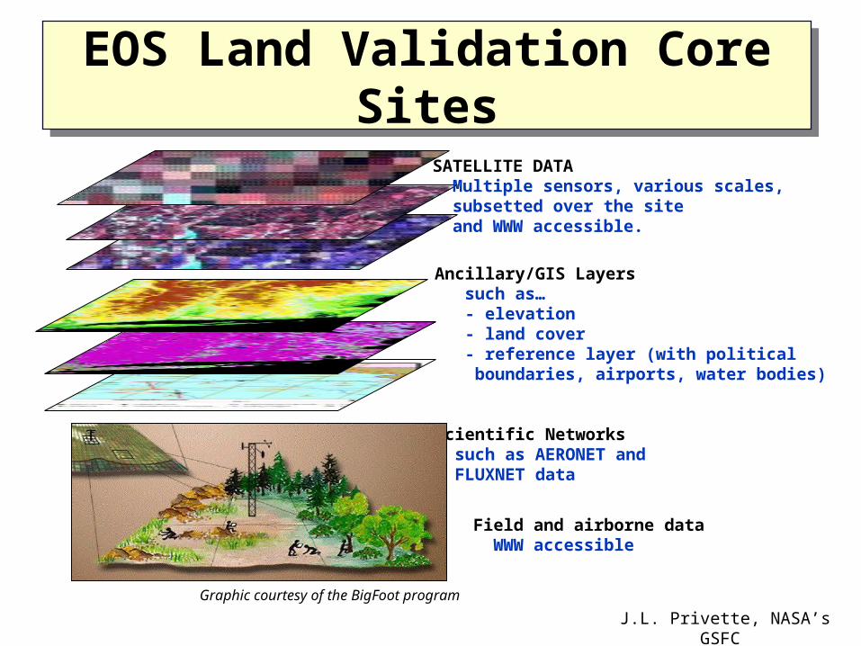
EOS Land Validation Core SitesEOS Land Validation Core Sites
SATELLITE DATA Multiple sensors, various scales, subsetted over the site and WWW accessible.
Ancillary/GIS Layers such as… - elevation - land cover - reference layer (with political boundaries, airports, water bodies)
Scientific Networks such as AERONET and FLUXNET data
Field and airborne data WWW accessible
Graphic courtesy of the BigFoot program
J.L. Privette, NASA’s GSFC
Examples of Emerging International Validation Networks and Activities
• Networks – Canadian LAI network (11 sites)– European VALERI (6 sites)– EOS Land Validation Core Site Network (23 sites)– Miscellaneous mission-specific networks (e.g. ASTER) – LPSIM Site Inventory (comprehensive list) – WGCV test site dossier (65+)
• http://spsosun.gsfc.nasa.gov/calval/query.html• Possibility of enhancing dossier to include LPV sites
• Activities– NASA’s Prototype Validation Exercise (PROVE)– DISCover Global Land Cover Validation– CSIRO ASTER Validation (Prata/Hook)

J.L. Privette, NASA’s GSFC
Majura ValleyMajura Valley Kioloa Kioloa
Moreton BayMoreton Bay
Lake GeorgeLake George
Batt ReefBatt ReefCooper CreekCooper Creek
MossmanMossmanDaintreeDaintree
Cape TribulationCape Tribulation
Townsville ReefTownsville Reef
Lake ArgyleLake Argyle
GoldsworthyGoldsworthy
Lake Eyre Lake Eyre Mt FittonMt Fitton
Uardry Uardry
Tinga tinganaTinga tingana
Tanjil BrenTanjil Bren
AmburlaAmburla
Port HedlandPort Hedland
KakaduKakadu
PanoramaPanorama
Hyperion SitesHyperion Sites
Other CSIRO SitesOther CSIRO Sites
KeyKeyToolabinToolabin
KunothKunoth
X band sitesX band sites
ThangooThangoo
Lake FromeLake Frome
CIGSN SitesCIGSN Sites
Endevour ReefEndevour Reef
Ray MertonRay Merton
Earth Observation CentreEarth Observation Centre
http://www.eoc.csiro.au
J.L. Privette, NASA’s GSFC
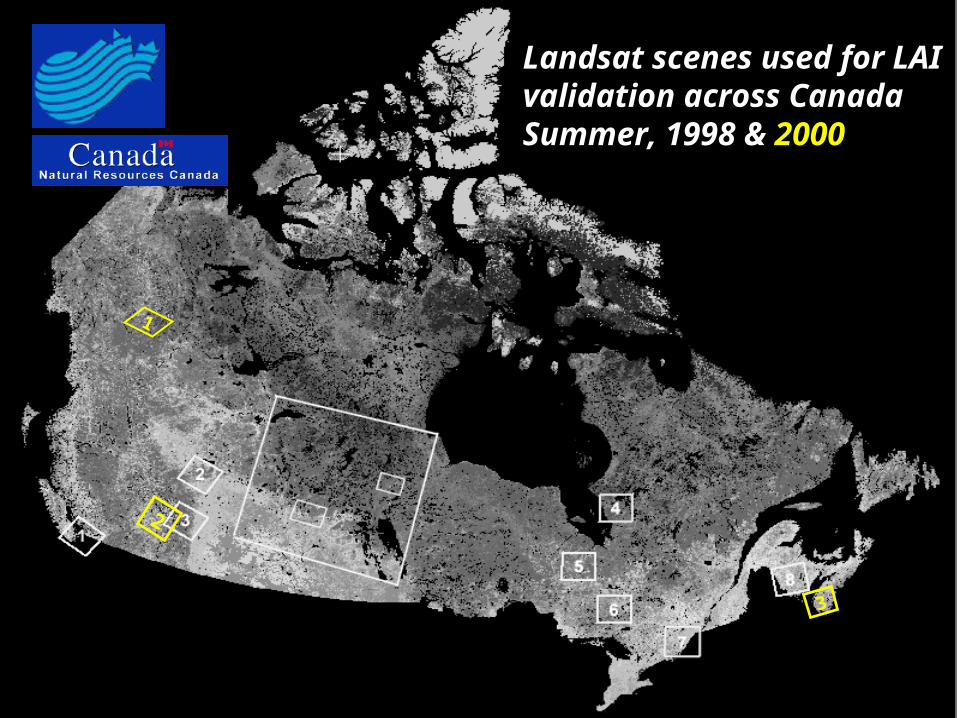
Landsat scenes used for LAILandsat scenes used for LAIvalidation across Canadavalidation across CanadaSummer, 1998 & Summer, 1998 & 20002000
1
2
3
J.L. Privette, NASA’s GSFC
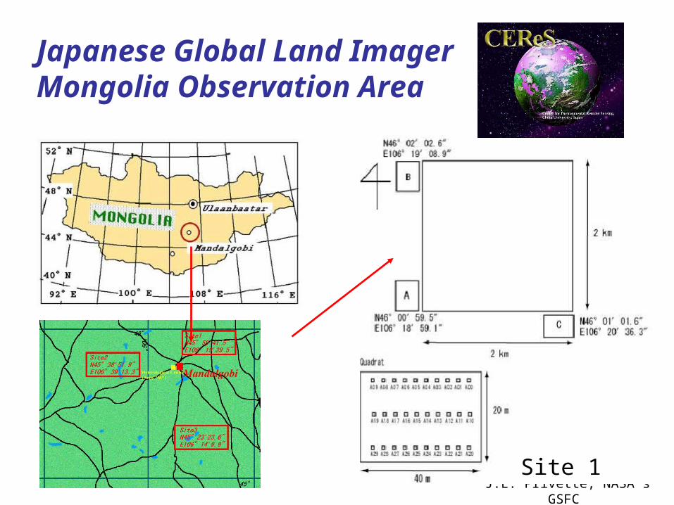
Japanese Global Land ImagerMongolia Observation Area
Site 1
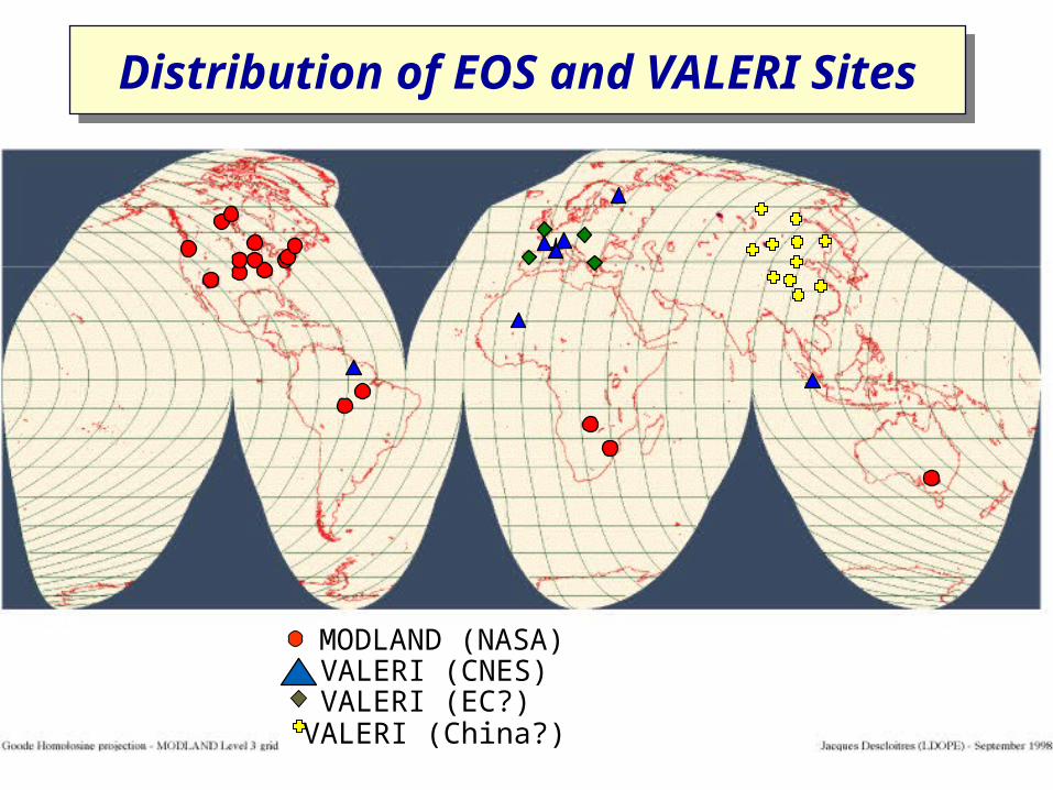
MODLAND (NASA)VALERI (CNES)VALERI (EC?)VALERI (China?)
Distribution of EOS and VALERI SitesDistribution of EOS and VALERI Sites
J.L. Privette, NASA’s GSFC
Sampling Issues• Sampling design and local scaling issues
– inconsistency in “point measurement” design/scaling
– destructive sampling vs. indirect instruments
– community requests for handbook of “best practices”• e.g., expanded BigFoot manual
• protocols of how measurements are taken, documented, sequence of activities, use of “black box” software from instrument vendors
• Field Instruments
– recommendations
– estimating products from surrogate parameters
– characterization (specifications)
– calibration
J.L. Privette, NASA’s GSFC
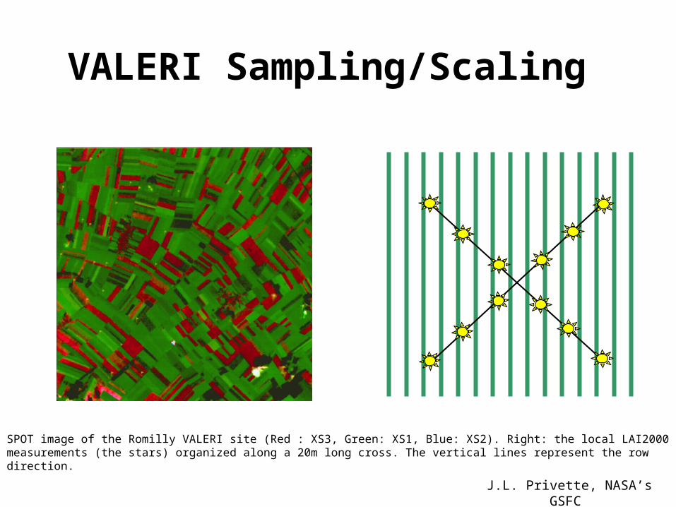
VALERI Sampling/Scaling
SPOT image of the Romilly VALERI site (Red : XS3, Green: XS1, Blue: XS2). Right: the local LAI2000 measurements (the stars) organized along a 20m long cross. The vertical lines represent the row direction.
J.L. Privette, NASA’s GSFC
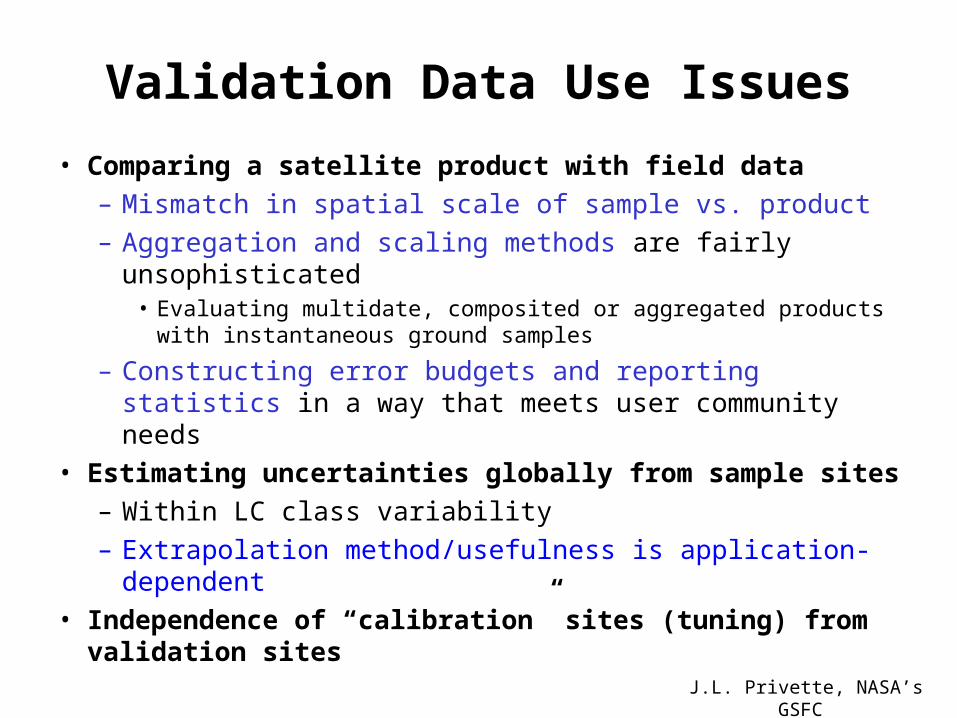
Validation Data Use Issues
• Comparing a satellite product with field data
– Mismatch in spatial scale of sample vs. product
– Aggregation and scaling methods are fairly unsophisticated• Evaluating multidate, composited or aggregated products with
instantaneous ground samples
– Constructing error budgets and reporting statistics in a way that meets user community needs
• Estimating uncertainties globally from sample sites
– Within LC class variability
– Extrapolation method/usefulness is application-dependent
• Independence of “calibration” sites (tuning) from validation sites

J.L. Privette, NASA’s GSFC
Activity 1: LAI Product Intercomparison
• 12-18 month pathfinder • Comparison of operational and research LAI
products at “non-calibration sites”• Initial emphasis on coarse-resolution sensors• Leverage Year 2000 field campaigns• Shake-out for more rigorous, longer-term and
multiproduct comparisons
J.L. Privette, NASA’s GSFC
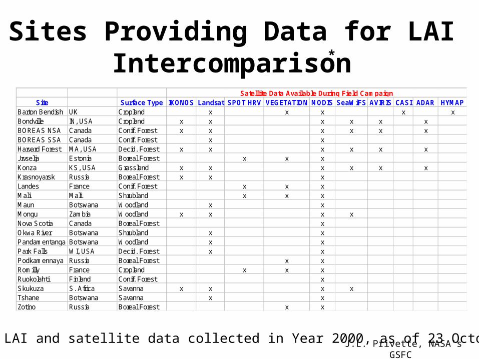
Sites Providing Data for LAI Intercomparison
Site Surface Type IKONOS Landsat SPOT HRV VEGETATION MODIS SeaWiFS AVIRIS CASI ADAR HYMAPBarton Bendish UK Cropland x x x x xBondville IN, USA Cropland x x x x x xBOREAS NSA Canada Conif. Forest x x x x x xBOREAS SSA Canada Conif. Forest x xHarvard Forest MA, USA Decid. Forest x x x x x xJrvselja Estonia Boreal Forest x x xKonza KS, USA Grassland x x x x x xKrasnoyarsk Russia Boreal Forest x x xLandes France Conif. Forest x x xMali Mali Shrubland x x xMaun Botswana Woodland x xMongu Zambia Woodland x x x xNova Scotia Canada Boreal Forest xOkwa River Botswana Shrubland x xPandamentanga Botswana Woodland x xPark Falls WI, USA Decid. Forest x xPodkamennaya Russia Boreal Forest x xRomilly France Cropland x x xRuokolahti Finland Conif. Forest xSkukuza S. Africa Savanna x x x xTshane Botswana Savanna x xZotino Russia Boreal Forest x x
Satellite Data Available During Field Campaign
* LAI and satellite data collected in Year 2000, as of 23 October 2000
*

J.L. Privette, NASA’s GSFC
Activity 2. Fire Products Validation
• Joint activity with GOFC Fire Team• Builds on Expresso, SAFARI, SCAR campaigns • Characterization and intercomparison of Active Fire products
– DMSP, AVHRR, ATSR, MODIS, GOES – Comparison with ground based fire data bases
• World Fire Web Validation• Development of a network of representative long term Fire
Validation sites • Field protocols for data collection for Burned Area validation
using high resolution data – ATSR, MODIS, AVHRR– GOFC Miombo Network pathfinding activity
J.L. Privette, NASA’s GSFC
Activity 3. Land Cover Product Validation
• Focus on global land cover classification, continuous fields and land cover change products– AVHRR,VEGETATION, MODIS, ATSR, GLI, VIIRS
• Builds on DISCover Validation approach and activity• Use of high resolution data for validating global
products– Landsat/SPOT– IKONOS
• Under development
J.L. Privette, NASA’s GSFC
LPV Subgroup Organization
• Chair: Jeff Privette (NASA)– Chairmanship tenure: 3-5 years
• Deputy Chair: Jeff Morisette (SSAI)• Implementation:
– Annual, topical workshops with designated workshop leaders: Reports, recommendations.
– Community activities design to address issues/problems in validation
J.L. Privette, NASA’s GSFC
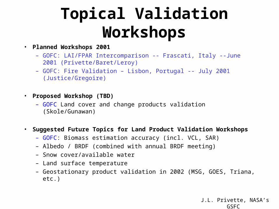
Topical Validation Workshops
• Planned Workshops 2001
– GOFC: LAI/FPAR Intercomparison -- Frascati, Italy --June 2001 (Privette/Baret/Leroy)
– GOFC: Fire Validation – Lisbon, Portugal -- July 2001 (Justice/Gregoire)
• Proposed Workshop (TBD)
– GOFC Land cover and change products validation (Skole/Gunawan)
• Suggested Future Topics for Land Product Validation Workshops
– GOFC: Biomass estimation accuracy (incl. VCL, SAR)
– Albedo / BRDF (combined with annual BRDF meeting)
– Snow cover/available water
– Land surface temperature
– Geostationary product validation in 2002 (MSG, GOES, Triana, etc.)