japan-australia workshop on non-meteorological applications from geostationary satellite data, 25-26...
TRANSCRIPT

Japan-Australia workshop on non-meteorological applications from geostationary satellite data, 25-26 August 2015, EcoSciences Precinct, Brisbane
Potential of Ocean Colour Observations from the Geostationary Orbit: Application
to Himawari‐8?
David Antoine
Curtin University1, Remote Sensing & Satellite Research Group (RSSRG), Perth, Australia
1. formerly at: CNRS-UPMC, Laboratoire d’Océanographie de Villefranche (LOV), France

Japan-Australia workshop on non-meteorological applications from geostationary satellite data, 25-26 August 2015, EcoSciences Precinct, Brisbane
OCR: Ocean Colour Radiometry
GEO: Geostationary orbit
Two basic acronyms

Japan-Australia workshop on non-meteorological applications from geostationary satellite data, 25-26 August 2015, EcoSciences Precinct, Brisbane
Science focus for OCR from the GEO orbit
Encompasses open ocean and the coastal environment.
Includes:
- The diurnal cycle of ocean optical properties, and its relation to physics and biogeochemistry
- Biological-physical coupling at (sub)meso scale- Data assimilation into coupled biological-physical models- Improved marine biogeochemistry and ecosystem models- Dynamics of coastal environments and ecosystems- Sediment transport- Aerosol transport- Land – ocean interactions- Operational services in the coastal zones
Therefore, basically the same objectives than for OCR from the Low-Earth-Orbiting Satellites
So: why the GEO orbit?

Japan-Australia workshop on non-meteorological applications from geostationary satellite data, 25-26 August 2015, EcoSciences Precinct, Brisbane
“In many respects, the polar-orbiting instruments study the effects of processes, whereas the geostationary instruments can study the process itself” (Chesters et al., 1998).
“The Earth has many fast (“weather”) and slow (“climate”) modes.. If we hope to make reliable predictions of weather and climate, we have to monitor land, sea, and air on their natural scales. The main energy pumps are the annual and diurnal cycles, each with comparable driving power. The Earth’s response to the cyclical solar drivers is episodic and irregular. Therefore we must resolve not only the seasonal cycle for many years, but also variations in the diurnal response cycle, … over the globe” (Chesters, Adler and others, 1998).
“The direct effect of man-induced changes might be more accessible to high-frequency observations, while the indirect effects are more accessible to classical low-Earth-orbiting satellites”
Chesters D. et al., 1998, Science benefits of advanced geosynchronous observations.
At http://rsd.gsfc.nasa.gov/goes/text/ags_science.html
Interests of the geostationary orbit: synthesis

Japan-Australia workshop on non-meteorological applications from geostationary satellite data, 25-26 August 2015, EcoSciences Precinct, Brisbane
OCR from the GEO orbit: overarching objectives
1. Within a range of conditions of observation (solar & view angles, clouds, …), the diel dynamics of the ocean will be accessible. The 1st objective in this case is to study the ocean ecosystem functioning at the diurnal scale. The diurnal cycle of photosynthesis / respiration .. generates a diel cycle in the particulate pool, hence of the optical properties and of the recorded signal2. In the above conditions and also when a little less observations will be available over a day, the 2nd group of objectives is related to observation & understanding of rapidly evolving phenomena (river outflows, aerosol plumes, phytoplankton blooms, (sub)meso-scale features ..). These phenomena are not necessarily linked to the biological functioning, and rather under the influence of physical forcings3. When the conditions of observation do not allow the diel changes to be sampled, there is still the capability to dramatically improve coverage, with at least one observation of good quality per day in many areas. This is of tremendous importance for all operational uses, from data assimilation into coupled biological-physical 3D models to services in coastal zones
Japan-Australia workshop on non-meteorological applications from geostationary satellite data, 25-26 August 2015, EcoSciences Precinct, Brisbane
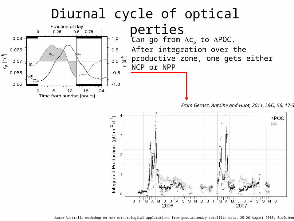
Diurnal cycle of optical properties
Can go from Dcp to DPOC.After integration over the productive zone, one gets either NCP or NPP
From Gernez, Antoine and Huot, 2011, L&O, 56, 17-36
Japan-Australia workshop on non-meteorological applications from geostationary satellite data, 25-26 August 2015, EcoSciences Precinct, Brisbane
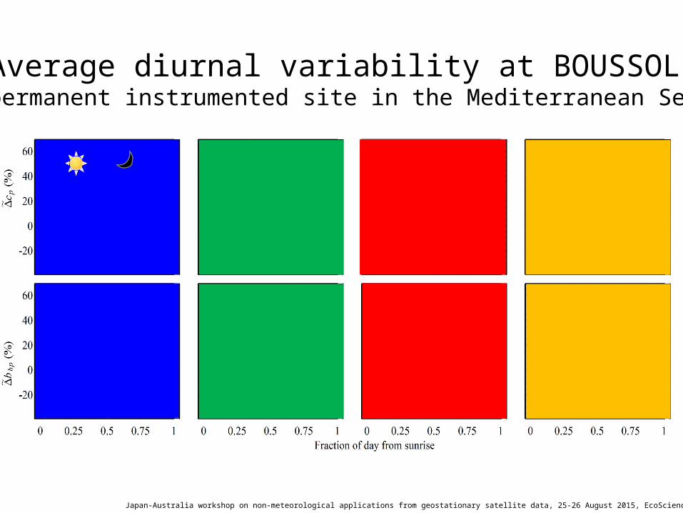
Average diurnal variability at BOUSSOLE(permanent instrumented site in the Mediterranean Sea)

Japan-Australia workshop on non-meteorological applications from geostationary satellite data, 25-26 August 2015, EcoSciences Precinct, Brisbane
Diurnal variability in bbp & POC from theRemote Sensing Reflectance?
DPOC derived either from Dbbp derived from apparent optical properties (i.e., reflectances) using 3 inversion algorithms, or from Dbbp derived from in situ bbp measurements
Kheireddine and Antoine, ongoing work
Japan-Australia workshop on non-meteorological applications from geostationary satellite data, 25-26 August 2015, EcoSciences Precinct, Brisbane
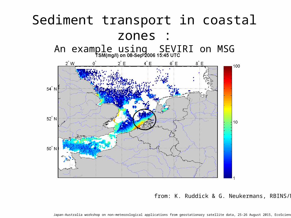
Sediment transport in coastal zones :An example using SEVIRI on MSG
from: K. Ruddick & G. Neukermans, RBINS/MUUM

Japan-Australia workshop on non-meteorological applications from geostationary satellite data, 25-26 August 2015, EcoSciences Precinct, Brisbane
Study / monitoring of aerosols
Typical average description from LEO satellites (Antoine & Nobileau,
JGR, 2006)
Daily variability at an AERONET site
Smoke plume, as an example of a dynamic feature badly sampled by LEO observations (Aqua MODIS image)
- Significant step to study dynamic aerosols (dusts, smokes, volcanic)- Better climatological representation of this rapidly evolving component of the atmosphere system

Japan-Australia workshop on non-meteorological applications from geostationary satellite data, 25-26 August 2015, EcoSciences Precinct, Brisbane
Use of ocean colour combined with altimetry to refine horizontal circulation
estimates at eddy scales
Gaultier et al., 2013
… new breakthrough in data assimilation required to benefit from future data types (e.g. from geostationary missions)
Slide courtesy: Pierre Brasseur, LGGE, Grenoble, France

Japan-Australia workshop on non-meteorological applications from geostationary satellite data, 25-26 August 2015, EcoSciences Precinct, Brisbane
Operational services in the coastal zones
HABs
Front detection Images courtesy, ACRI-st
Such services exist as demonstration studies.Truly operational services are rare, however, because the availability of LEO observations is insufficient Very high potential of the GEO observations
The quality / reliability of these services is, again, much dependent on the significant improvements we’ll be able to bring to ocean color interpretation in optically-complex waters

Japan-Australia workshop on non-meteorological applications from geostationary satellite data, 25-26 August 2015, EcoSciences Precinct, Brisbane
IOCCG (2012). Ocean-Colour Observations from a Geostationary Orbit. Antoine, D (ed.), Reports of the International Ocean-Colour Coordinating Group, No. 12, IOCCG, Dartmouth, Canada.
Japan-Australia workshop on non-meteorological applications from geostationary satellite data, 25-26 August 2015, EcoSciences Precinct, Brisbane
How all this applies in the case of Himawari8-9?
- Himawari8-9 do not host ocean colour sensors
- The AHI has 3 broad bands in the visible: 470, 510, 640 nm, plus 860 nm in the NIR (and not the typical >10 spectral bands of OCR sensors)
- SNR ?
- Still, this is similar, even better, than SEVIRI on METEOSAT: 560 and 740 nm only
Therefore, although the AHI is far from being an ideal ocean colour sensors, there is potential for exploratory
demonstration studies

Japan-Australia workshop on non-meteorological applications from geostationary satellite data, 25-26 August 2015, EcoSciences Precinct, Brisbane
Opportunities for collaborative work aroundHimawari8-9
- Algorithm development
- Calibration / validation activities (e.g., through the Australian Integrated Marine Observing System, IMOS)
- Joint scientific activities or proposals for data exploitation
- Co-supervision of students?
- Working together on advocacy for future Earth observation sensors (ocean colour) on geostationary platforms In which frame, with what support &
funding?

Japan-Australia workshop on non-meteorological applications from geostationary satellite data, 25-26 August 2015, EcoSciences Precinct, Brisbane
“OCAPI”Ocean Colour Advanced Permanent Imager
The European GEO OCR mission
Status, as of August 2015

Japan-Australia workshop on non-meteorological applications from geostationary satellite data, 25-26 August 2015, EcoSciences Precinct, Brisbane
OCAPI: the “goal” (ideal) mission elements- Observation of all ocean areas (open + coastal) on the Earth disk
at a ~1h temporal resolution from a geostationary orbit- Step & stare concept- 250m GSD @ SSP- 18 bands from 395 to 1020 nm (OLCI compatibility)- High SNR required for ocean colour (~2000 @ 1-km resolution)- On-board calibration devices (solar diffusers)- Other characteristics typical of what’s required for ocean colour
(see IOCCG reports #12 & 13)

Japan-Australia workshop on non-meteorological applications from geostationary satellite data, 25-26 August 2015, EcoSciences Precinct, Brisbane
Where do we stand? (August 2015)- First proposal to CNES in spring 2008 (built from past experience
and other proposals for GEO or LEO missions led by our group)- Presented at the CNES quadrennial prospective seminar in March
2009 identified among the priorities- Submitted in June 2010 to the “Earth Explorer 8” call from ESA
Excellent reviews but not selected because of cost and uncertainties on launcher options
- An adapted version (much simpler) was proposed as a hosted payload aboard a telecomm satellite (hosted payload call from ESA in fall of 2011). Not selected.
- “Phase 0.2” studies have been conducted under CNES responsibility, as 2 parallel studies by Astrium and Thales-Alenia-Space (TAS). Concluded in March 2013. Led to select the 250-m option for possible continuation
- OCAPI was again presented at the 2014 CNES quadrennial prospective seminar. It again received full support from our community
- We are seeking for international collaboration/support- Science studies progress in parallel (diurnal cycles,
assimilation…)- A “Phase A” study has formally started, with the aim of submitting
a proposal to the ESA 9th Earth Explorer call (likely mid 2016). Will be a simplified version of the “ideal OCAPI”, for being proposed as a hosted payload on a commercial platform

Japan-Australia workshop on non-meteorological applications from geostationary satellite data, 25-26 August 2015, EcoSciences Precinct, Brisbane
Thank you
NASA SeaWiFS mission composite (Chl-a and NDVI), projected on the Earth disk as seen from the geostationary position 0°-140°E
Generated with http://oceancolor.gsfc.nasa.gov/cgi/biosphere_globes.pl