january 26, 2016 - san antonio€“4 drainage manual contents transportation & capital...
TRANSCRIPT

–1
CITY OF SAN ANTONIO
TRANSPORTATION & CAPITAL IMPROVEMENTS
UDC AMENDMENTS
& DRAINAGE MANUAL
JANUARY 26, 2016
PRESENTED BY: JACOB POWELL

–2
Storm Water Changes
–2Transportation & Capital Improvements
Appendix H
Stakeholder Input
UDC Amendments
Drainage Manual
UDC Text Changes
• 35-504 removed and replaced with Appendix H
• 35-B119 (checklist) revised and moved to Appendix H
Conceptual Change
• Policy & Reference Manual
• Expanded subject matter
Design & Submittal Changes
• Rational Method up to 200 acres
• Pipe Size & Materials,
• Velocity Controls (stilling basins, dissipators)
• Easements widened for concrete channels
Other Changes
• Appendix F Revisions
• Storm Water Utility Fee
• Regional Storm Water Management Participation Form

–3
Drainage Manual Contents
–3Transportation & Capital Improvements
Chapter 1 Introduction
• Acronyms and abbreviations
Chapter 2 Drainage Policy
• Policy & Principles
• Technical Criteria
• Implementation
Chapter 3 Drainage Law
• Regulations & Statutes
• Rules & Ordinances

–4
Drainage Manual Contents
–4Transportation & Capital Improvements
Chapter 4 Planning
• Regional Storm Water Management Program
• Adverse Impact Analysis
• System Criteria
• Planning
Chapter 5 Hydrology
• Rational Method
• Hydrograph Method (SCS)
Chapter 6 Pavement Drainage
• Design Guidelines & Street Classification
• Street Capacity
• Slopes
• Unflooded Access

–5
Drainage Manual Contents
–5Transportation & Capital Improvements
Chapter 7 Storm Drain
Systems
• Hydraulics- Partial Flow & Pressure Flow
• Energy Losses
• Pipe/Box Size & Placement
• Materials & Specifications
Chapter 8 Inlets
• Inlet Types
• Design Guidelines
• Materials & Specifications
Chapter 9 Open Channels
• Hydraulics & Flow Classification
• Hydraulic Jump
• Design Guidelines
• Maintenance & Easements
–6
Drainage Manual Contents
–6Transportation & Capital Improvements
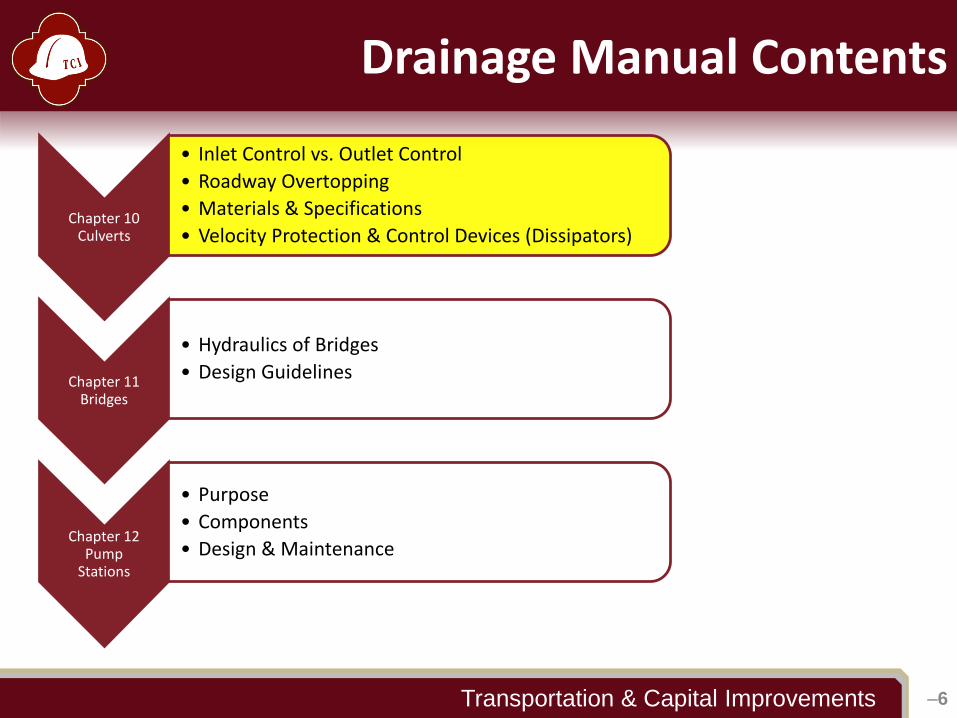
Chapter 10 Culverts
• Inlet Control vs. Outlet Control
• Roadway Overtopping
• Materials & Specifications
• Velocity Protection & Control Devices (Dissipators)
Chapter 11 Bridges
• Hydraulics of Bridges
• Design Guidelines
Chapter 12 Pump
Stations
• Purpose
• Components
• Design & Maintenance

–7
Drainage Manual Contents
–7Transportation & Capital Improvements
Chapter 13 Storage Facilities
• Detention & Retention Basins
• Inflow & Outflow Structures and Downstream Analysis
• Maintenance Considerations
Chapter 14 Drainage
Easements
• Storm Drains & Open Channels
• Storage Facilities
• Maintenance Access
Chapter 15 Lots/Unflooded
Access
• Lot Grading
• Unflooded Access
• Fence Crossings
Chapter 16 Vegetation
• Recommended Vegetation
• Tree Preservation

–8
Drainage Manual Contents
–8Transportation & Capital Improvements
Chapter 17 Software
• H&H Tools
Chapter 18 Data Sources
• Local/Regional/Federal
Chapter 19 Definitions
• Definitions
Appendices
• Appendix A- Storm Water Submittal Review Checklist
• Appendix B- Missouri Charts

–9
Key Changes
–9Transportation & Capital Improvements
Submittals & Resubmittals
• One (1) hard copy & one (1) digital copy
• Clarifies separate submittal packages for plats and permits
Hydrologic Methods
• Peak Flow
• Rational < 200 acres ≤ Unit Hydrograph
• Detention
• Modified Rational < 20 acres ≤ Unit Hydrograph
• Multiple Ponds- Unit Hydrograph
System Design
• Pipe Material- RCP under streets
• Pipe Diameter- allows < 24” for laterals and driveway crossings with Director approval
• Velocity Controls/Energy Dissipators
–10
Key Changes
–10Transportation & Capital Improvements
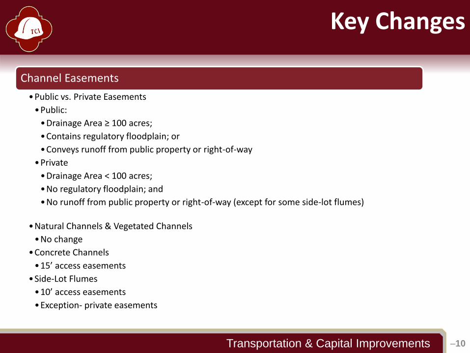
Channel Easements
•Public vs. Private Easements
•Public:
•Drainage Area ≥ 100 acres;
•Contains regulatory floodplain; or
•Conveys runoff from public property or right-of-way
•Private
•Drainage Area < 100 acres;
•No regulatory floodplain; and
•No runoff from public property or right-of-way (except for some side-lot flumes)
•Natural Channels & Vegetated Channels
•No change
•Concrete Channels
•15’ access easements
•Side-Lot Flumes
•10’ access easements
•Exception- private easements
–11
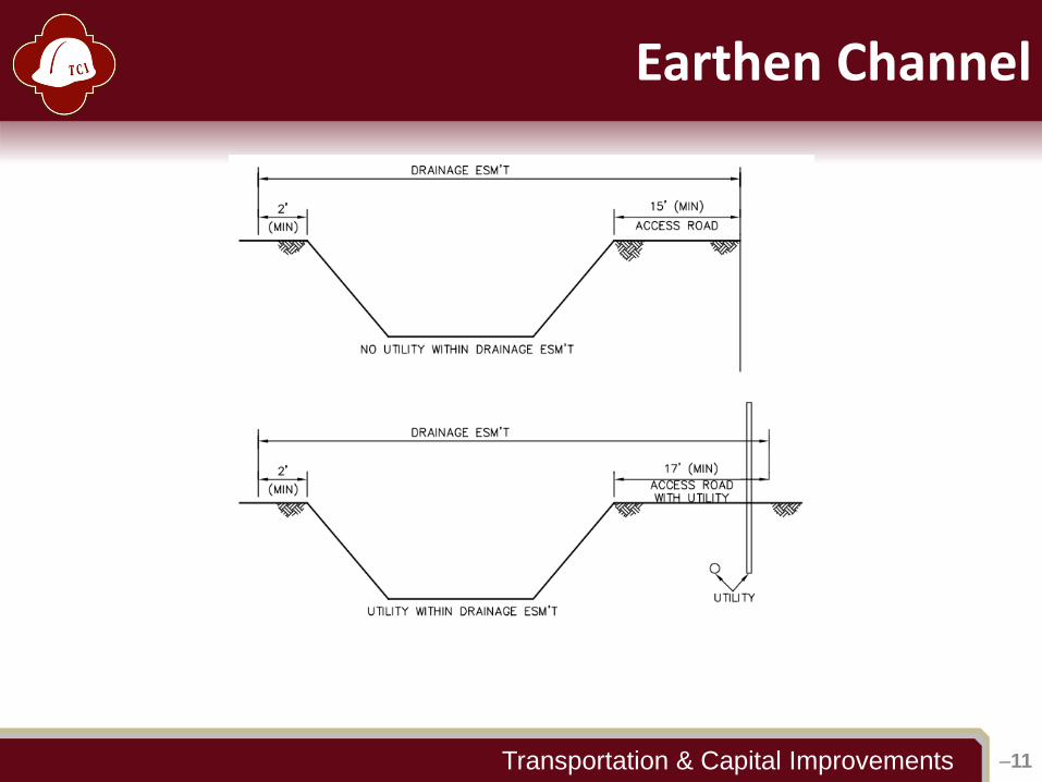
Earthen Channel
–11Transportation & Capital Improvements

–12
Concrete Channel
–12Transportation & Capital Improvements
–13
Side-Lot Flumes
–13Transportation & Capital Improvements
14.3.1.4 Concrete Flumes
Side-lot flumes are concrete-lined channels that convey storm water runoff
between residential lots from street to street or from a street to a storm drain,
drainage channel, natural creekway, or floodplain. Easements for side-lot
flumes shall extend a minimum of two (2) feet on one (1) side and ten (10) feet
for access on the opposite side.
Private side-lot flumes shall have appropriate easement widths as determined
by the developer’s engineer.
–14
Appendix F (Floodplain) Revisions
–14Transportation & Capital Improvements
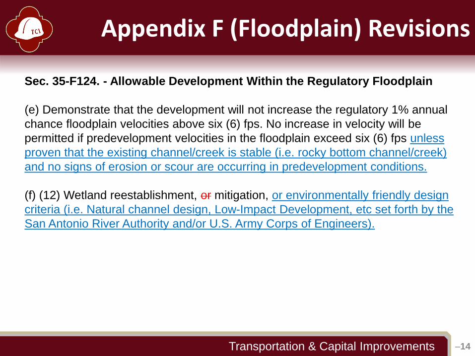
Sec. 35-F124. - Allowable Development Within the Regulatory Floodplain
(e) Demonstrate that the development will not increase the regulatory 1% annual
chance floodplain velocities above six (6) fps. No increase in velocity will be
permitted if predevelopment velocities in the floodplain exceed six (6) fps unless
proven that the existing channel/creek is stable (i.e. rocky bottom channel/creek)
and no signs of erosion or scour are occurring in predevelopment conditions.
(f) (12) Wetland reestablishment, or mitigation, or environmentally friendly design
criteria (i.e. Natural channel design, Low-Impact Development, etc set forth by the
San Antonio River Authority and/or U.S. Army Corps of Engineers).
–15
Appendix F (Floodplain) Revisions
–15Transportation & Capital Improvements
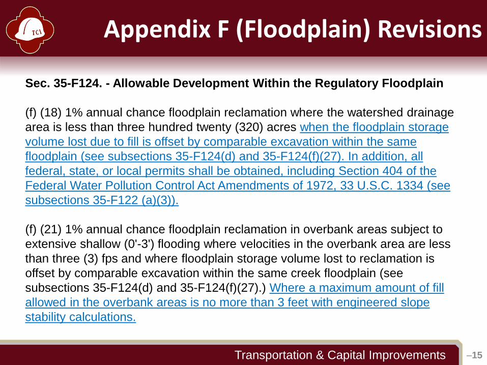
Sec. 35-F124. - Allowable Development Within the Regulatory Floodplain
(f) (18) 1% annual chance floodplain reclamation where the watershed drainage
area is less than three hundred twenty (320) acres when the floodplain storage
volume lost due to fill is offset by comparable excavation within the same
floodplain (see subsections 35-F124(d) and 35-F124(f)(27). In addition, all
federal, state, or local permits shall be obtained, including Section 404 of the
Federal Water Pollution Control Act Amendments of 1972, 33 U.S.C. 1334 (see
subsections 35-F122 (a)(3)).
(f) (21) 1% annual chance floodplain reclamation in overbank areas subject to
extensive shallow (0'-3') flooding where velocities in the overbank area are less
than three (3) fps and where floodplain storage volume lost to reclamation is
offset by comparable excavation within the same creek floodplain (see
subsections 35-F124(d) and 35-F124(f)(27).) Where a maximum amount of fill
allowed in the overbank areas is no more than 3 feet with engineered slope
stability calculations.
–16
Appendix F (Floodplain) Revisions
–16Transportation & Capital Improvements
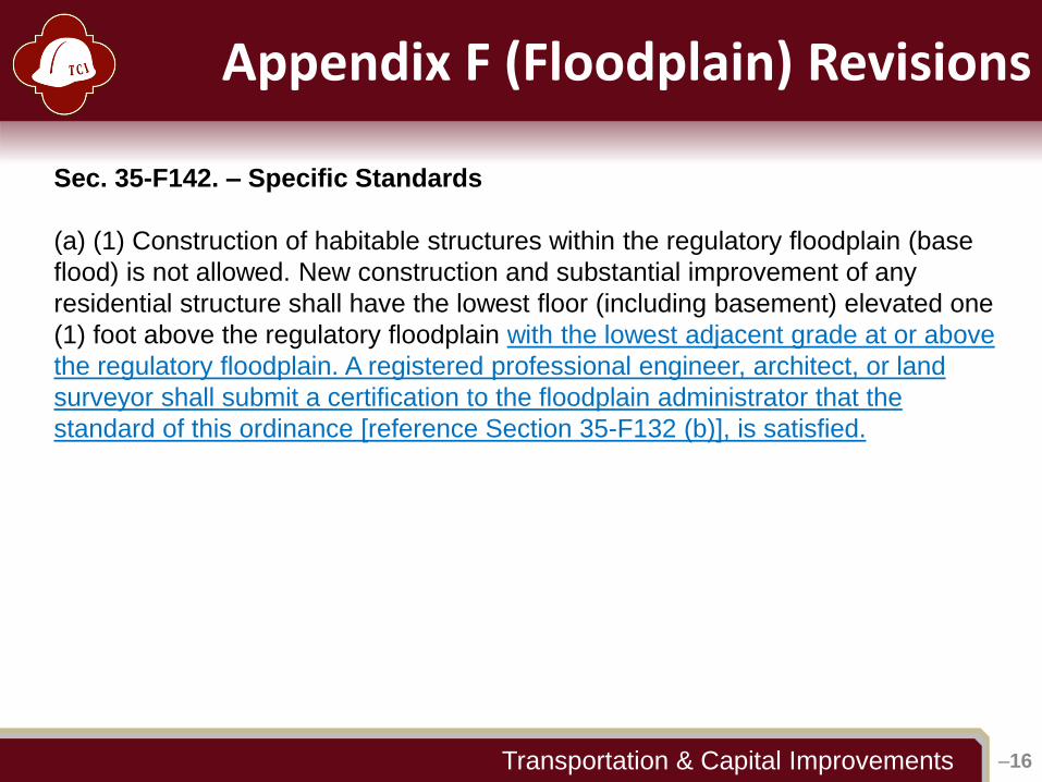
Sec. 35-F142. – Specific Standards
(a) (1) Construction of habitable structures within the regulatory floodplain (base
flood) is not allowed. New construction and substantial improvement of any
residential structure shall have the lowest floor (including basement) elevated one
(1) foot above the regulatory floodplain with the lowest adjacent grade at or above
the regulatory floodplain. A registered professional engineer, architect, or land
surveyor shall submit a certification to the floodplain administrator that the
standard of this ordinance [reference Section 35-F132 (b)], is satisfied.

–17
Other Changes
–17Transportation & Capital Improvements
LID and RIO Reviews
• Low Impact Development (LID)
• Voluntary
• Ordinance pending
• Credit and Fee-based Incentives
• River Improvement Overlay (RIO) District
• LID Mandatory in some areas (approx. 600 acres total)
• San Antonio River Authority (SARA)
• SARA to serve as staff augmentation for TCI
• Comments sent with drainage/flood reviews

–18 –18Transportation & Capital Improvements
Questions?
JACOB POWELL, PE, CFM(210) 207-0176