j bureau of mineral resources geology and geophysics. · j . i '" t j commonwealth of...
TRANSCRIPT

J . i '"
t J
COMMONWEALTH OF AUSTRALIA.
DEPARTMENT OF NATIONAL DEVELOPMENT .
BUREAU OF MINERAL RESOURCES GEOLOGY AND GEOPHYSICS.
RECORDS.
1955/7
DIN.rOND DRILLI,~G Arf THE BTJ~RUliDIE RADIJAC'i:IVE PROSPECT.
BURR Ulif DIE If. T.
by
.DIAMOND DRILLn~G AT THE BURRUiiDIE RADIOACTIVE PROSP.L1~CT',
SUWfi.ARY·
INTRODUCTION
GEOLOGY
DRILLING'
CONCLUSIONS
REFERENCES
APPENDIX 1 APPE:"~DIX 2
Plate 1.
Plate 2.
Plate 3.
,BURRUIfDIE, N. T •
. by
J. B. FIRMAil"
RECORDS
QONTENTS
Situation and access Previous investigations Acknowledgements
DRILL DATA SUMMARY GEOLOGICAL LOGS.
Illus:trations
Page
1
1
1
2
2
2
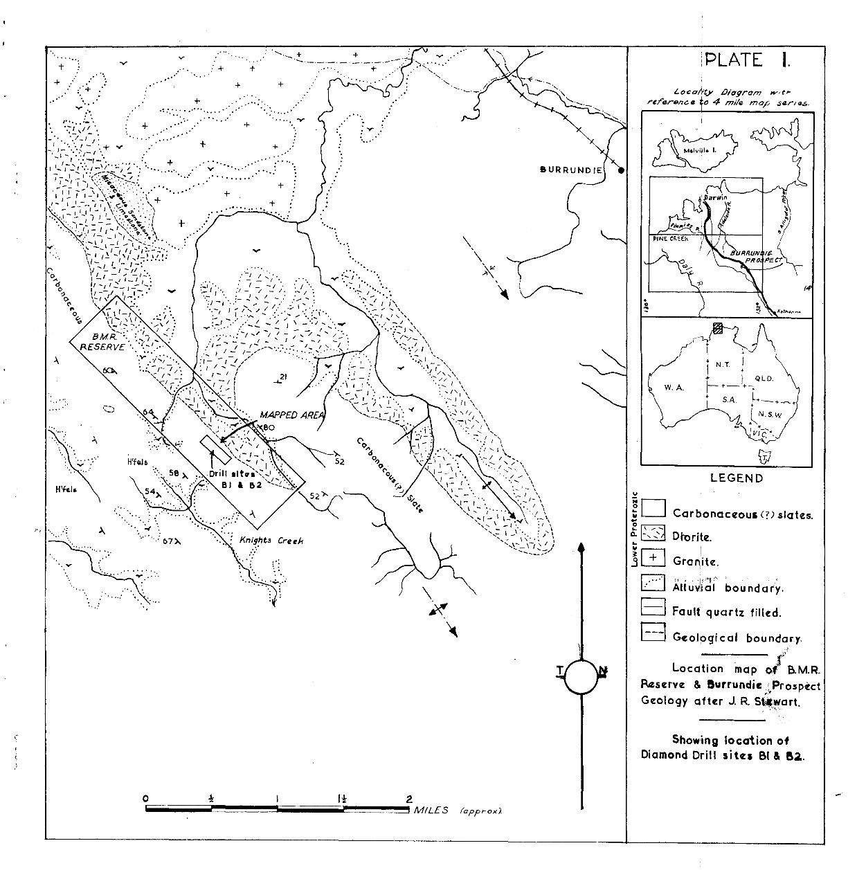
Location map of B.M.R. Reserve and Burrundie Radioactive Prospect, showing drill sites B1 and B2. Scale 2 ins. = 1 mile (approx).
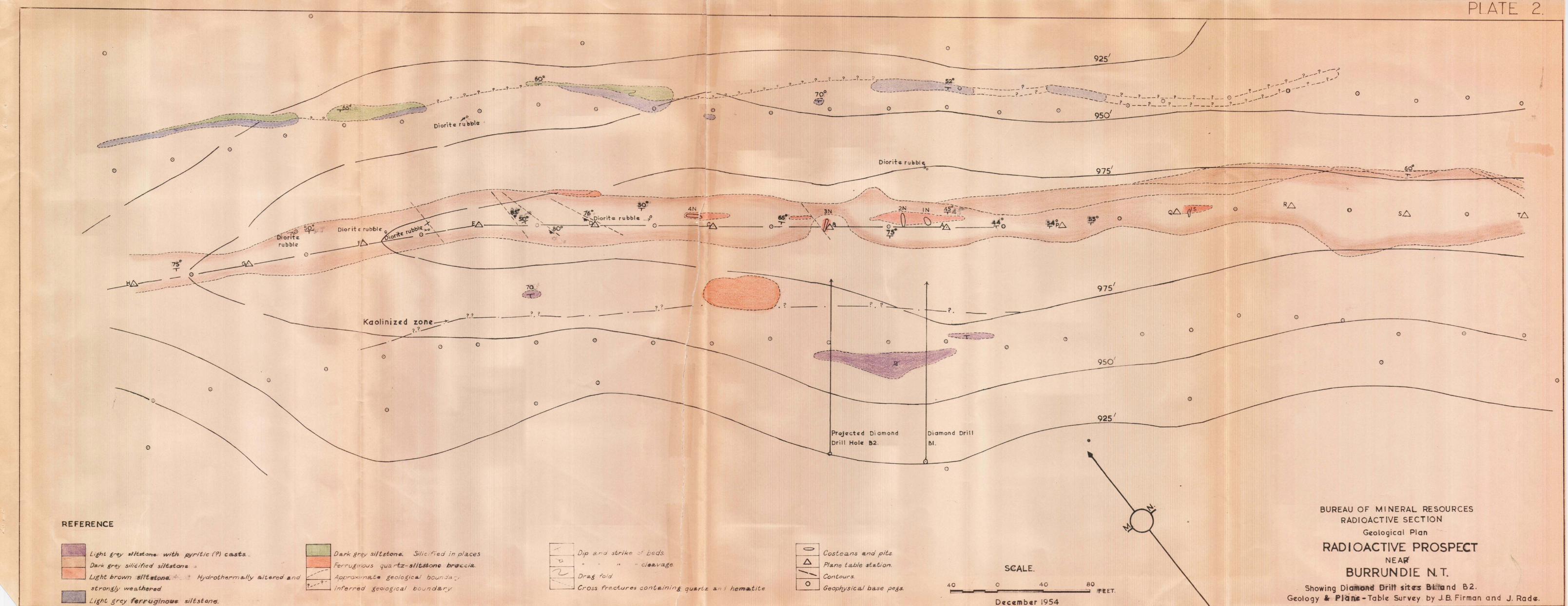
Geological plan. Radioactive prospect near Burrundie, N.T., showing drill sites B1 and B2. Scale 1 inch = 40 ft.
Section through Diamond Drill Hole B1. Scale 1 inch = 10 ft.
..
..
..
SUMMARY
The Bureau of Mineral Resources began diamono drilling at. t~:: '?>nrl'undie Radioactive Prospect near Burrundie SidLl'lg, N.T., on 22nd Octobel', 1954. Drilling ceased on 22nd December, 1954, on the completion of the first hole •
Significant radioactivity, with a maximum of 3 times b~ckground in one place/was found in a few small outcrops of a light brown ferruginous rock which is gossanous in places. The radioactive outcrops are found in an area about 10 feet wide and 450feet long.
Diamond drilling was carried out to test mineralisation and radioactivity at depth. The drill passed through argillaceous siltstone to 185 feet where diorite was encountered. The diorite continued to the end of the hole at 218 feet. Pyrite was identified in the diorite, but no uranium minerals were found and bore logging showed very low radioactivity.
INTRODUCTION
§ituation and access
The Burrundie Radioactive Prospect is situated three and a half miles on ~ true bearing of 242 degrees from Burrundie Siding, which is on the North A.ustralian Railway. The prospect is about 95 miles south-east of Darwin.
Access to the prospect is by a rough track which runs in a southerly direction from Grove Hill along Saunders' Creek.
Previous investigations
Significant radioactivity was first discovered on 20th May, 1954, by members of a Bureau of I.iineral Resources party led by B. P. Walpole. The prospect area was mapped in detail between 25th June, 1954 and 2nd July, 1954, by members of the Darwin Uranium Group. The results of the geological and geophysical work are contained in a report by Rade, Firman and Misz (1954).
GEOLOGY
Metamorphosed sedimentary rocks, which are thought to be of Lower Proterozoic Age (Noru~es, 1949" crop out in tbe area. The sedimentary rocks are Siltstone, shale and slate which form part of a conformable sequence on the west limb of a large south-plunging anticline. The siltstone in the prospect area has been folded and subjected to cataclastic metamorphism (followed by injection of diorite) and later fracturing and shearing followed by metasomatism.
Radioactivity is restricted to a few places in a zone about 10 feet wide and 450 feet long, which occurs within a bed of dark grey siltstone. The radioactive host rock is a leached ferruginous rock, light bro~l in colour, which is gossanous in places. The highest radioactivity measured w~s 3 times background in costean I~ (Plate 2). The best sample taken for radiometric assay contained 0.009 per cent" e U308. Radiometric traverses indicate that the surface radloactivity is extremely localised and of low intensity. No uranium minerals were identified during the surface mapping.

2
• • The radioactive deposit at Burrundie is of a type
not previously investigated in the ~orthern Territory. For this reason two exploratory drill sites were chosen to teet mineralisation and radioactivity at depth.
DRILLING
Drilling began at the B1 site on 22nd October, 1954, and finished on 22nd December, 1954, at a depth of 218 feet. Drilling proved extremely difficult and sludging had to be abandoned due to loss of water.
Diamond drill hole B1 was put down to test for a continuation of the radioactivity fOlli1d at the surface. The hole was sited to intersect the lode at a vertical depth of 250 feet below the outcrop showing highest radioactivity. An intersection was made with diorite at a drill depth of 185 feet.
The following mineralisation occurs in the diamond drill hole: Abundant pyrite in the diorite, pyrite casts in the sediments, quartz and iron in small irregular fractures in the siltstone and kaolin in kaolinised sediments. No uranium minerals were seen in the core.
The highest readings (400 counts per minute) were made during radiometric bore logging at depths between 124 and 128 feet and 130 and 134 feet in kaolinised argillaceous siltstone. A sample of the core between 130 and 132 feet yielded only 0.007 per cent e U308. The lowest readings (less than 100 counts per minute) were recorded in diorite (Plate 3}.
CO~WLUSIONS
The low radioactivity in the drill hole and the Rbsence of uranium minerals in the core indicates that this type of deposit is unlikely to yield economic concentrations of uraniwn. No further drilling is rec ommended.
" REFERENCES
Noakes L.C., 1949
Rade, J., Firman, J.B., and Misz, J.B., 1954 .•
Stewart, J. R., 1954
A geological reconnaissance of the Katherine-Darwin °K-egion, Northern Terr i tory. Bur. Min. Resour.~. Bull:-:i6.-
Preliminary geological and geophysical report on the Burrundie Prospect, Northern Terri tory. Rec. 1954/
Reconnaissance geological report Burrundie ladio~ctive Prospect Reservation. Bur. Min. Resour. Aust. Unpublished report.
-APPENDIX 1
.DRILL DATA.

· DIAI10HD DRILJJ HOLE
· Drill
Drill direction
Inclinat ion
. ~
Drill depth to intersection
Vertical depth below surface
Percentage core recovery
Footage drilled per week
R1
Edeco
038i degrees
69 degrees
188 feet
250 feet
52 per cent.
27 feet .
,][~D DRILL HOL~
Brill direction
Incl ina t ion.
Drill depth to intersection
Vertical depth below surface
Drilling not commenced
Ja2.
038it degrees
60 degrees
199 feet.
250 feet

APPENDIX 2
-SU1li'flARY GEOLOGIOAL LOGS.

DIAlIDND DRILL HOLE B1.
Depth
/,0- 5 ft. 6 ins.
5 ft. 6 ins. - 7 ft.
7 ft. - 30 ft. 6 ins.
30 ft. 6 ins. - 31 ft. 6 ins.
31 ft. 6 ins. - 32 ft.
32 ft.
34 ft. - 35 ft. 3 ins.
35 ft. 3 ins. - 39 ft. 3 ins.
39 ft. 3 ins. - 40. ft. 3 ins.
40 ft. 3 ins. - 40 ft. 9 ins.
40 ft. 9 ins. - 42 ft. 5 ins.
42 ft. 5 ins. - 47 ft. 6 ins.
47 ft. 6 ins. - 62 ft.
62 ft. - 66 ft. 9 ins.
66ft. 9 ins. - 123 ft.
123 ft. - 135 ft.
135 ft. - 158 ft.
158 ft. - 169 ft. 9 ins.
.Remarks
Soil f
Dark grey argillaceous siltstone. Iron-stained vein guartz between 6 ft. 4 ins. and 6 ft. 6 ins.
Grey argillaceous siltstone. Pyrite casts between 19 ft. 6 ins. and 23 ft; small amount of vein quartz between 23 ft. and 28 ft. 3 ins.; shear 10 degrees to hole at 7 ft. 6 ins.
Dark grey argillaceous siltstone. I.t'on and kaolin 011 sU.t'faces of irregular fractures.
Kaolin.
Light grey argillaceous siltstone.
Kaolinised siltstone
Light grey argillaceous Siltstone; sheared at 20 degrees to hole between 35 ft. 3 ins. ana 36 ft. 3 ins.; irregular fractures are iron-coated.
Dark grey argillaceous siltstone. Shears at 39 ft. 9 ins. and 43 ft. 3 ins.
Reddish-grey a.t'gillaceous siltstone. Shea~ at 40 ft. 9 ins.
Kaolin
Fe~ruginous quartz siltstone breccia.
Kaollnised siltstone.
No core
Dark grey argillaceous siltstone. Irregularly fractured and pitted or sheared in soma places; ferruginous bands between 93 ft. and 108 ft. and 118 ft. and -123 ft.
Bleached and kaolinised rock with velnlets of kaolin or talc.
Dark grey argillaceous siltstone. Pitted, and has thin ferruginous bands in places; contains iron and quartz in thin fractures; quartz vein 12 ins. wide between 153 and 158 feet.
Missing.

169 ft. 9 ins. - 174 ft. 9 ins.
174 ft. 9 ins. - 180 ft.
• 180 ft. - 185 ft. 3 ins.
185 ft. 3 ins. - 215 ft.
215 ft. - 218 ft.
Ferruginous argillaceous siltstone
Ferruginous argillaceous siltstone; bleached and contains small ~ounts of quartz •
Dark grey clay
Diorite with shears 30 degrees to hole, irregular fractures, a few quartz veinlets and pyrite. Some of the shears are clay filled.
Abund~nt pyrite from 215 - 218 ft. Chlorite on irregular fracture surfaces.
'. '" '0.
+ • 'f,
+ .. :;. .' :. .
.'
v
," ..
·.V
'-.-- + ""---'-'-'-
+ -y. _. ___ ._._",' ............... ,0
+ . '<", "
v
+ + .....
'-. ,.'
+ + .' ~ .
+ ," . .,:: •••• ,0--'
' .. '0 " " :
,0' '0 0'
+ '0 ••• . ...
+ '. ........ .... . -',
" to'
". : ". ". :.r ".
........ ." 67)"
....
+
+ . ..... ...,..
+ ., . 0 0 ' '0:' '0
v .0 ••• : • •••••• of
+ •••••• eo • ' • . , .
. ....
+
+
'. '"
....
. ... ' .
:v .' .....
:.'-.! !....~./ ". f -/. : / ....
...,. :.- ,.... ... '--:"~ ~ .... : ... :1 - "/ _ /. :' I ':
. .:- ..!. , / ..... : ,/ ..... . ',: I -I .... ..... ,. - / ,,0 .:.: l ..... ,' '. - I ~ I .... " / •••• .: •• , i'.
• I I .................. / .... .", '0:.... " .- -.'. / \ . I . : -' ... ' .... -!.. -. _ J -' , ......... '0 ..".
...... '.' , - - - ..... ' . . . , '. '. : .... , ..... / / / - / ' /... / -' '. .: / "" -' - ..! - .... - I __ I - / '" -, :
:1 '; /.! ,!./.#" ... _ ........... : ..... ::.':~ ..... ;'\ . :' ,:.. - 1 - / /' : I / - ...... ,' • ,_ I (
...... 21
Creek
. ' .. . . : . . '.
'0 .. ,"'" '0: '. _, 1 1\ . - ....... "'" \ . ,
',-;-1 .. ./", "0/ - / ,
• ' •• ~.-:: I ...... '" ',/y- , ',....... I "
' •• ~' / I \ . \
'.:--" J ....... , -, - , '. \ ,- "
'or /'" \. .:---,/ / " ......... I \
: ..... ,' J \
. '.- , 1\" . - \
':"': ,/ / '\ ... :-, .. .,1 .... \
......... / / \ . '- " . ::.! / .... '1
.' \ ." / '- I \ . " ' .. -- / / ..........
.............. j" ;' '\ ", , ........... , ,
", / -"'" \ ',' \
• I \ .-- - \
'._ I \ . -, .... \
". I \ '. / \
",- " ',..... -I' '/ \ ..... - ,'0 : ..... \ .....,- ,- .... :" \
..... ,- \ \ '. . .... \' \-", I ' ..... ..;:- ..... _,1 ---_ .... '
u
!PLATE I. LocahV lJiagrcm wit,..
rererel1ce ~o 4 mile mop sr.zrlfJ.,S.
LEGEND
~D Carbonac~OUi (n .slat~5. ., eO/-a. - " , .... ...
~GJ D EJ B
DtbritlZ.
I Gran!jt~ .
,., . . ·1, ,"* ,.', Alluvtal boundar'y .
Fault] quartz 1iJ(~d .
Geolpgi cal boundary.
Location ,1"/
map Qf B.M.R.
Res~rv~ & lSurrundie ~Prosp~ct /',
Gq:ology after J. R S~,!!art.
Show'ing location of Diamond Drill sitfZl 81 & &2..
o PlATE
o o
o 925'
o (') o o
___ --------,~ Dioriter u bbl ~, _______________________________ ~~~ __ --__.~~~:=:=:::-.-~-~-,---~-~-~-~-~-~-~-~-~-~-~-=-~-~-~~~~~::~~==::~::::~;;~~::~~~==~==~~~~~~ ~ .,. --- 975' . - - - ---~---- - - ~d' ____________ __________ ' __ - _ ___ ... - - - ~_::.::_ -__ --:-: -=:~ _-.---=-:r------ ....... --... -_ - - --- ... - - - --' :....- - - - -- .. :;::::::-->
------ --- ~.:==.:::::---~=~---- ------------------::::::: -- <... ... : -- .... .... ..... .... --... , --------------- ... --'" .... - ' -, " '" ----- -"" ~ ,," '.... -------- ----- ---- ------------------- _...... .. ....... , ---- -,," "'- ---- -----------
\-;---;~---- -~~;;---- ~~-~-::?i ">----- __ ------------------- Q~_- nCC:~; o ~ '~-::--~)<~~ --\< <::::~;-Q~~~~ ~(S ~~~£-:::: ' -~~~-- ---- - ~b ~~//-~--------- ---_ lJ
--., ... ... \ ' ........ ... - ~ -----------------.. - ......... ....... ... - -- - ... -----_ ... ----- ----_ ... ------- -------------------------
o o
_-------------,,--. :;:------ - -~-__ --:;~~;;~;~~.=-:1_ -----_ _____ _ ___________ -__ -"'- .... - ----. -- --------'---- . .... --- ..... ............... ,so __ - -- ' ,ili- '~ '- 1i60 -r 4 N --- ~ " «:--,c-----:.:' __ ------------- '\ S!t " ~ .... Diorit fZ rubble -.:,0 - -- .p __ ___ _
. ___ -50 . .. - :x E.6-----.C'~ a' -'--;:-;;=----~ < 0 ----~----__ ... .:...1':'\ ~~ Diorit~ rubblt 0 u,O,OVl.7 0 ' -..-----' ,~~,Oo ...... ....... , . • . '- . \'t< , 0 - , . -____ /--/-~~o:~~: .-Yb. ,0' _-------'----- --------- -- -- ' --- 0--- J --------- ----- ---------- --
-------------- ---------
o o sL::. o T~ ----------------------- ---....... "
~---------.... '- .... ~ ...........
, ----
... ----------- ------------... ----
~-------""'.::::::-=.~ .. ............ . --_ ... -
... ------ ----------------------------
---------
o
o
REFERENCE
Dark grey s l/(e ifled :jf"/t6 t an lIZ ~
70 _ (=T.~)
, ,-----_ ... . ---------~---'7"""::..:.----'-'-----------~-----' . ? --- - . -----__
_______ Kaoliniud zone ..-:"'~"·
7"--.<
~. ---- 0 0 0 0 ___ ~ 0
o
o o o
(')
o
§ L/tht g r tty .. lIt d QI't-.- w i th pyritic ( PJ c a..s t s. ""
LIght hrown ifilt #tMB. • Hydrother m aJ(y "' Itere d .. nd
1-_-1 Dark aro/ Si/tstDne. Silic ~;e d in places
f-- ---4 r errUr!'flov$ qua r t:.z- 3/1t#on61 brIl'Cci& .
j.::,_/~~ Approx"na. t . ge%t/elL i b OUII.:id:., ? -? .... -- .
stront(Y weather.a. Inf'err e d g eo1og·(caJ bO v '7 da, CY
------/,-- ---- "'" --.. ... ... , , I I , I
\... {
.... _----- ------- _ ... /' , ?
o
hematite
o ___ ,... .. ------ r."
ProJfl ct~d Oi am o nd
DrHI Hole 82 .
= CosCe ans tLn d pits.
f-~=---4 Plane table .. t .. t ion. --- Contour s . o
'-_---' Geoplzysic aJ ba-se P"8s.
1---_? .
Di amond Dr ill
&1.
(')
o
•
SCALE.
40 0 40 80
975 1
o o
o
950'
o
925 '
•
o (')
o
BUREAU OF MINERAL RE50 UR CES RADIOACTIVE SECT ION
Geologic al Plan
RAD I OACTIVE PROSPECT N EA~
BURRUNDI E N. T. Showing Diaril'OAd Drill sit n B'tlta nd B2 .
o
2.
Geolo gy Ir PHrn&- Table Su r ve y by J. B. Fi rman and J. Rade. Light grey f'.rr{Jglnoll' sili$tonlS.
""""_ """" ...... ~=="'""''''"'' ___ ........ ?? 1I'.fET.
Decem ber 1954
o

,
. , S3830W
C","" lOOP
o
~O
t:.0
<:>0
RL 925 to.t.
1
'00
~ Iron-stained vC'in quartz bqtwllcn 6 ft. 4 tns_ & 6 tt.6 ina.
-E- Shl'or 10" to holcz.
~ Small amounts 01 vqin quort:. blltwa:tn 23 1c:~t I 28 1'CZ'CZ't 3 ins.
+- Sh .. orcrd at 300 to hole bcztwlll.ri 35 1q «t 3 in. &: 36ft. 3 il'ls.j irrcrgular iron-rlolntZ.d fractura.s.
gO
at 39 ft. 9 In & 43 ft 3 Ins
Fcrrruginous
\)\
\ .\ , . , C ",'.
..
. , \
c'" \ '\c'?'
FllrrLL<;lnous bands b«twQa.n 93 ofaa.t &. lOB hqt & 118 11l'Zt. & 1231'CZ'ct,
Irrez julor frocturlZ's & shelors in soma p!ocas.
, \
\ IC,'? ..
, '.
Thin farruginotls bonds in som,z plOClt5 I
/
,ron' &. -Qu(frt-1" In lnlrl--"'f1lc.tur(l_~-- - -- -~r-
I
\~\~Quarh
\\~) "qin.
I , , I
I
, I ,
I
, I
I I
I I
I
,
, , , ,
I
I
I I
I
, , I
I
I
I
, I ,
I , I
I I ,
I ,
I I , , ,
I I
I
I I
I /
Blqochczd, contains smaf1 amounts 't<lin quortz.
I
I I
/
/ I
I I
I
,
I I
/ I ,
/
I /
I
I
I /
I
I /
/ I
I I
I I
/ I
/ I
I
,
I /
/ I
/ I
, I ,
I I
I
I I
I I
I I
I I
I
I
I I ,
/ I
I I
I
I I
/ I
I I
/ I
/ I
I I
I I
I
I I
I I
I I
/
I I
I
I I
I I
I I
I
LODE ---___ !~.L 1000 tt
I I
I I
I
/
/ /
/
I I
I
I I
I I
I
I ,
, I
I /
I /
I
, /
I I
/
I /
I
/ I
TroclZ of blldding from surfacer
I I
I
/ I
I /
I I
I I
I
I I
I
, , I
I
I /
I
/
I /
I
I I
/
I
I , I
I I
I
I I
I
D ~ ~ P77l ~
D IT]
L~ B
, I
I /
I I
I ,
I I
/
I
, , I
I /
LEGEND
Argil1acoaous siltstone. Ferrug"nous (Fe), Kaolini.ed
O~artz siltstone breccia.
Diorite.
Dark grey cl ay.
No corll·
50; I.
Pyrite.
Pyrite cash.
[~ Kaolin.
BUREAU OF MINERAL RESOURCES
Darwin Uranium Group
SE.CTION THROUGH DIAMOND DRILL HOLE B I NEAR
Burrundie N. T. 5howing Geology and Radiometric Log
GlZo!ogy by J. B. Fi rman Geophysi cs by G F. Clarke
o 10 20 30 = --- ::::-=--- Fellt December 1954.
/ I
(Kl
PLATE 3.