it’s island time! · it’s island time! ... april 10-11, 2015 rosenberg library ... morning, by...
TRANSCRIPT

A N E W S L E T T E R O F T H E T E X A S M A P S O C I E T Y Spring 2015
For meeting details, please see pages 3- 4.
It’s Island Time!Texas Map Society Spring Meeting
April 10-11, 2015Rosenberg Library • Galveston, Texas
CaptionsPostcards of Galveston, ca. 1910, UT Arlington Libraries Special Collections, AR311 and AR416
Background Map: Richardson's Map of the City of Galveston in 1859: from Sandusky's Survey made in 1845; including improvements in public buildings, wharves etc. to the present date.
Lithograph, 32 x 47 cm. (New Orleans: J. Douglas, 1859). UT Arlington Libraries Special Collections
2 • The Neatline
FROM THE PRESIdENT FROM THE EdITOR
The Neatline is published semi-annually by the Texas Map Society • c/o Special Collections The University of Texas at Arlington LibraryBox 19497 • 902 Planetarium Place • Arlington, TX 76019-0497http://www.TexasMapSociety.org
For more information contact David Finfrock - Editor, Texas Map Society.Email: [email protected]
Texas Map Society members and others who helped produce this issue are: Shirley Applewhite, George Dailey, Evelyn Edson, David Finfrock, Carlos Furuti, James Harkins, Frank Holcomb, Ben Huseman, Dianne Powell, Nick Stockton, Matt Walter, and our graphic designer Carol Lehman
A Neatline is the outermost drawn line surrounding a map. It defines the height and width of the map and usually constrains the cartographic images.
3 • The Neatline
Happy, happy greetings to you, not only for the New Year, but also for a new regime of the Texas Map Society.
It seems just like yesterday that I had accepted the position of 2nd VP of TMS, and then moved to 1st VP, and all of a sudden, here I am---President. My first e-mail of 2015 was from Gerald, explaining to me that I was now in charge. What a cold dose of reality that was!
Speaking of Gerald, there are many, many things for which I am grateful to him. It would take a very long epistle to enumerate all of them. The one I want to highlight most, is the wonderful legacy that is in place due to his leadership over many years, not just during his term as president. During his term of office the past two years we have had great programs and speakers. Our meetings have been well-attended. Our membership is strong and growing. Financially we are in the black. And he will always be remembered as the leader who successfully led us in the 1st ever Map Fair of the West, which was truly a success in every sense of the word. Thank you, Gerald, for a job “Well Done!”
I must share with you my thoughts as I take the reins of TMS. It has been like becoming a parent, believing you know how and what to do. You have the baby. Then reality hits. And suddenly you realize you don’t have the foggiest idea what to do. At this point, the learning curve is steep—and fast!
So… here we are finalizing plans for our Spring Meeting in Galveston, April 10-11. The venue is at the Rosenberg Library, which is such a treat in and of itself. The line-up of speakers is sure to educate, as well as entertain us. Galveston is a destination unto itself: so much history, such interesting architecture, many museums to visit, and, of course, the beach—sand, sea, waves, sunrises, and sunsets. I do so hope each of you will put this on your calendar. Come join us!
When I discuss the Texas Map Society, first and foremost is always the love of maps---what they show us, teach us, how we use them, the artistry & beauty of them. One aspect of TMS I rarely put into words is the comradery and friendships that we have as a result of being members of TMS. There are so many people whose paths we would not have crossed. Rarely do we see some of them other than at the twice-yearly meetings. So, in addition to the education we receive from scholars and aficionados, and having access to rare and beautiful maps, it is the friendships we make that are so precious!
Thank you for the opportunity to serve you. Together I want us to strive and work as a team to keep our Society on the same high plane that it has been presented to me. - Shirley F. Applewhite, TMS President 2015-2016
As a meteorologist with KXAS-TV, NBC5 in Dallas-Fort Worth, I get to work with maps every day. Of course, they are usually weather maps. But I love all kinds of maps, especially antique maps, and the history that goes along with them.
Since 2011, The University of North Texas has been digitizing antique maps as part of their Portal to Texas History. http://www.ntxe-news.com/cgi-bin/artman/exec/view.cgi?archive=45&num=72106
Then this past January, my own TV station entered into a partnership with UNT’s Portal to Texas History. As described in this link, NBC5 is providing decades of our old news film archives to UNT for digitization: http://www.nbcdfw.com/profiles/local/DFWThe-Portal-to-Texas-History-287968361.html
As a promotion to raise additional funds for that digitization effort, NBC5 aired a series of stories illustrating some of the film that has been entered into the Portal to Texas History. Here is a contribution that I wrote on weather stories during the drought-plagued summer of 1956: http://www.nbcdfw.com/video/#!/news/local/Texas-Portal--Covering-Severe-Storms-in-1956/288619081
Always remember that all of the archived editions of The Neatline, and much more information on the Texas Map Society can always be found at our website at: www.TexasMapSociety.org
- David Finfrock

3 • The Neatline
It’s Island Time!Texas Map Society Spring Meeting
April 10-11, 2015 • Rosenberg Library • Galveston, Texas
Continued on page 4
This year’s Texas Map Society’s Spring Meeting will be held Saturday, April 11th at the Rosenberg Library (2310 Sealy Street, Galveston 77550-2220 • (409) 763-8854). Festivities actually begin the day before (Friday afternoon, April 10th) with historical tours of the city and a reception at the Moody Gardens Hotel, located at #7 Hope Boulevard. At the Rosenburg Library, TMS members can either catch one of two private historical tours of the city at 3:00 or 4:00 p.m. Please indicate which tour time when you register for the meeting online or you will not be guaranteed a seat on the tour bus. Seating is limited. If the worst happens and you cannot secure a seat, TMS members are encouraged to enjoy a leisurely visit to one of the island’s many tourist attractions on their own. All those signed up for the meeting may attend the reception at the Moody Gardens Hotel which begins at 7:00 p.m. Meeting packets will be available then as well.
On Saturday morning there will be a continental breakfast at the Rosenberg Library from 8:30-9:15. Late registrants can pick up program packets at this time as well. The Saturday program begins at the Wortham Auditorium of the Rosenberg Library at 9:15 a.m. The first speaker will be Dr. Marvin Applewhite of the Applewhite-Clark Collection in
Texas Map Society Heads for Historic Galveston!By Ben Huseman
Fort Worth, presenting on “Edwin Ward Moore: Commodore of the Republic of Texas Navy and Mapmaker of the Texas Coastline.” After a break, Andy Hall, Faculty Associate at the University of Texas Medical Branch at Galveston and Marine Archaeological Steward of the Texas Historical Commission will present “Treacherous Shoals: The U.S. Coast Survey and the Civil War in the Gulf of Mexico.” Lunch will be served in the Rosenberg Library’s Fox Room from 11:45-12:45 p.m.
In the afternoon, Ben Huseman, TMS Secretary and Cartographic Archivist at the University of Texas at Arlington Libraries’ Special Collections will try to keep everyone awake after a good lunch with his presentation “Track Lines, Whistle Stops, and Czech Points: Visualizing Immigrant Routes to and within Texas.” Following a break, oil and gas expert Dr. Robert Cargill, Jr. of Dallas will entertain and inform with “The Great Texas Oil Heist.” After one more break, Dan Reilly, Warning Coordination Meteorologist for the National Weather Service in Houston/Galveston will speak on the important issue of “Mapping of Texas
4 • The Neatline
2015 Spring Meeting continued
Hurricanes: Past and Present.” Continuing with a focus on the present and perhaps future of cartography, Joshua Been, Social Science Data Librarian for the University of Houston Library will educate us all about some of the marvelous “Trends in Online and Mobile Mapping.”
Following Closing Remarks from 5:15-5:30 p.m., TMS President Shirley Applewhite invites all meeting attendees to gather at 7:00 p.m. for a Post Meeting Dinner (Dutch Treat) at the Compass Room, Olympia Grill, 21st Street and Harborside (Pier 21).
The cost of registration is $115 before April 6 and $125 after April 6 and includes not only the lectures, but also the historic tour, Friday reception, Saturday continental breakfast,
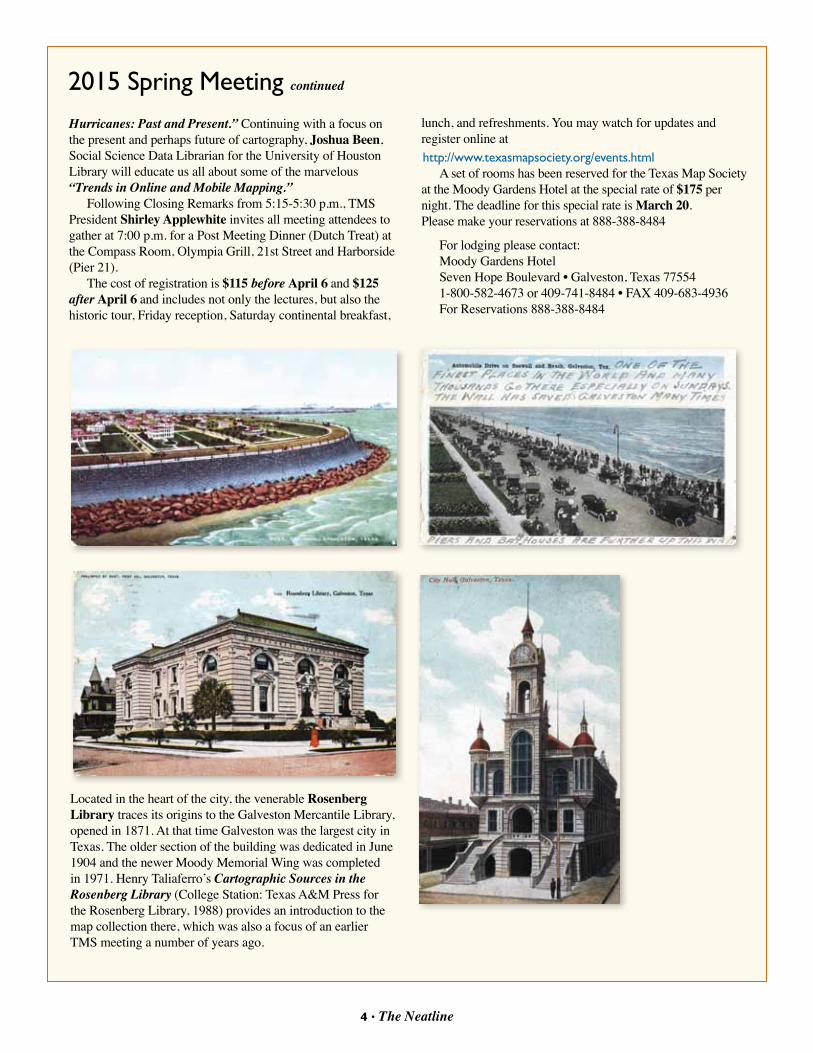
Located in the heart of the city, the venerable Rosenberg Library traces its origins to the Galveston Mercantile Library, opened in 1871. At that time Galveston was the largest city in Texas. The older section of the building was dedicated in June 1904 and the newer Moody Memorial Wing was completed in 1971. Henry Taliaferro’s Cartographic Sources in the Rosenberg Library (College Station: Texas A&M Press for the Rosenberg Library, 1988) provides an introduction to the map collection there, which was also a focus of an earlier TMS meeting a number of years ago.
lunch, and refreshments. You may watch for updates and register online at http://www.texasmapsociety.org/events.html
A set of rooms has been reserved for the Texas Map Society at the Moody Gardens Hotel at the special rate of $175 per night. The deadline for this special rate is March 20.Please make your reservations at 888-388-8484
For lodging please contact: Moody Gardens HotelSeven Hope Boulevard • Galveston, Texas 77554 1-800-582-4673 or 409-741-8484 • FAX 409-683-4936For Reservations 888-388-8484

5 • The Neatline
The Texas Map Society held its annual fall meeting at the University of Texas at Arlington, this time in partnership with the Rocky Mountain Map Society. The meeting, held in conjunction with the Virginia Garrett Lectures on the History of Cartography, focused on the theme of Manifest Destiny. Two days of lectures were followed by another two days focused in map collecting, at the Map Fair of the West.
The programs began on Thursday, October 16th, with a presentation by David Narrett of UTA, “From the Past to Futurity: John Hamilton Robinson’s Map of Mexico and the Trans-Mississippi West, 1819”. Imre Demhardt, also of UTA, spoke on “Fifty Years of Being Tardy: The U.S. Army Corps of Topographical Engineers and its Military Mapping, 1813-1863”. Following those afternoon presentations, attendees enjoyed a cocktail reception, and a tour of the cartographic exhibit in Special Collections, assembled and curated by Ben Huseman.
A full day of activities resumed on Friday. After a light breakfast, outgoing TMS President Gerald Saxon welcomed everyone to the lectures. The first of the morning, by Jimmy L. Bryan of Lamar University, was a fascinating discussion of “Lands Contiguous: Maps and the Imagined Destiny of Expansion”. He was followed by Steven Woodworth of TCU, who spoke on “The Mexican Cession and the Coming of the Civil War”. After a break for lunch, during which discussions of cartography and manifest destiny continued at each table, TMS members held a business meeting, and elected new Officers and Board Members to guide the society in the coming years. The first lecture of the afternoon was a stimulating one, offering a different view of what manifest destiny meant to the Americas. Alex Hidalgo
2014 Fall Meeting of the Texas Map Society
The Price of Manifest Destiny:War and American Expansion, 1800-1865By David Finfrock
Augustus Mitchell, Map of Mexico, Including Yucatan and Upper California, exhibiting the Chief Cities and Towns, the Principal Travelling Routes & c., 1847, color transfer lithograph, 43 x 64 cm. (Philadelphia: S. Augustus Mitchell, 1846). Virginia Garrett Cartographic History Library, Special Collections, UT Arlington Libraries.
Continued on page 6TMS President Gerald Saxon welcomes members to the Virginia Garrett Lectures.

6 • The Neatline 7 • The Neatline
2014 Fall Meeting continued
discussion, “After Disunion: Confederate Manifest Destiny”, part lecture and part stand-up comedy, kept everyone awake and engaged. Ben Huseman then again invited everyone in to Special Collections for a guided tour of the map exhibit he had designed to accompany the Virginia Garrett lectures. Later in the evening, the lectures resumed after a cocktail reception, and dinner. Susan Schulten of the University of Denver gave the Keynote Speech on “The Sectional Crisis and the Remaking of the American West”. She discussed how the Civil War was caused by a struggle not over the existence of slavery in the south, but by its possible extension into the west, and how a focus on historic maps can show the ways in which the sectional crisis fundamentally shaped the identity and future of the west.
The Texas Map Society extends special thanks to UTA for hosting the Virginia Garrett Lectures again, to the Rocky Mountain Map Society for partnering with us on our four day cartographic extravaganza, and–- to the Dallas Biblical Arts Center, for hosting the Map Fair of the West.
Jimmy L. Bryan explains how the maps of Manifest Destiny functioned as propaganda meant to inspire U.S. territorial nationalism.
TMS members gather to examine maps in UTA's Special Collections.
All photos courtesy of David Finfrock
of TCU discussed “Coping with Loss: Antonio Garcia Cubas’ Atlas Geográfico (1858) and the Uses of History in Independent Mexico”. The last lecture of the afternoon was by Donald S. Frazier of McMurry University. That time slot, after lunch, and a series of other lectures, can sometimes be deadly. But his lively
Steven Woodworth explains how the end of the Mexican War led inexorably to the beginning of the Civil War.

7 • The Neatline
Headline News: The 1st Ever Map Fair of the West in Texas was held in conjunction with the fall 2014 Virginia Garrett Lectures and the Texas Map Society and Rocky Mountain Map Society meeting in Dallas on October 18-19 and was an unqualified success! Yes---this is the assessment of everyone involved: organizers, promoters, map dealers, sponsors, map society members, and attendees.
Let me tell you….this did not just happen by accident. A great deal of planning (starting two years before the event), months of discussion and communication, cooperation and advice from the Rocky Mountain Map Society (our co-sponsors), and just plain hard work on the part of your Texas Map Society officers and board (led by then-president Gerald Saxon), and the ever-necessary army of volunteers.
For a number of years there had been talk of holding a map fair in the Metroplex. In 2012 the talking became serious, especially after the Rocky Mountain Map Society agreed to partner with us, guiding us in this endeavor.
What a godsend they were! Since they have held map fairs in Denver for several years, their guidance and leadership were invaluable.
As with any new adventure, there were pitfalls, disappointments, and problems along the way. That is to be expected. Perseverance and adaptability became the passwords for the committee.
What always brings fear and trepidation to an exercise like this is: “You do all the planning and hard work, and then: No one shows up!” Or, “No one buys”. And---you always are afraid of the financial responsibilities! In the case of the “Map Fair of the West” none of these scenarios took place!
Just to give you a brief summary of what was involved in bringing to fruition the successful map fair:
1. Early stages of planning the fair were held during the Summer of 2012 in Denver, at the joint meeting of the Rocky Mountain Map Society and the Texas Map Society.
2. Once a Map Fair committee was selected, individual assignments were made.
3. Locating a convenient venue is always an issue. (Location! Location! Location!) As it finally evolved, the Museum of Biblical Art in Dallas was perfect: adequate space, beautiful surroundings, great location and a helpful staff
4. Selecting and sending out invitations to map dealers—literally all over the world, was made easier by a list provided by our Rocky Mountain friends and the hard work of Myron West, a map dealer himself and a RMMS member.
5. The onsite work involved creating an actual layout of the floorplan, defining options for entry into the museum
during its business hours, taking in the monies of attendees, etc. TMS is indebted to member and former president George Tobolowsky for sponsoring a reception onsite for the map dealers. Other generous support for the fair came from California map dealer Barry Lawrence Ruderman, former TMS president Dianne Powell, Scott Peck and the Museum of Biblical Art, and the Rocky Mountain Map Society.
6. The hiring of a professional publicist turned out to be money very wisely spent.
7. Finally, the physical preparation for the event (set-up, draperies, tables, chairs, etc.) was accomplished by Myron West and staff members of the museum.
8. The first day of the event, we discovered that a Susan G. Komen race was running by the Museum which meant that several streets in the area were blocked.
(Best laid plans of mice and men…!): The BIG Question: Would attendees brave the obstacles and come anyway??? And: HOO-RAY! They did! There were approximately 250 paying customers the first day. The second day there were another 100+ attendees. The week before our event, most of the map dealers had been at a map fair in another city and expressed disappointment at the low turnout of attendees in that city. They were elated by the numbers we had in Dallas.
As always, dealers are anxious to see if the attendees were coming just to look, or if there would be buyers. And: HOO-RAY! There were buyers!
Think back to the beginning of this article: All the planning & preparation certainly paid off to make our 1st Ever Map Fair of the West an unqualified success!
An important point to remember: like other societies similar to ours, your officers and board members are all volunteers! We all accept that responsibility,
Knowing this in advance: But to plan and execute an event like the map fair truly is above and beyond the usual call to duty.
One of the major benefits to TMS associated with the map fair needs to be specifically highlighted: the publicity generated for the fair raised the public awareness of TMS. There were newspaper articles, radio interviews, and teachers bringing students to the fair, parents exposing their children to maps, and people just curious or looking for a particular map. All of this adds up to potential new TMS members!
To me, the real proof of the success of the map fair was that the dealers asked when our fair was going to be held again, and said that they wanted to be included!
FYI: the ball is in the Rocky Mountain Map Society’s court. Our agreement with them was that we would do the map fair in 2014, and the next one in two years (2016) would be up to them. SO—Stay Tuned!!!
Map Fair of the WestBy Shirley Applewhite
For Map Fair of the West photos, please see page 8.
8 • The Neatline
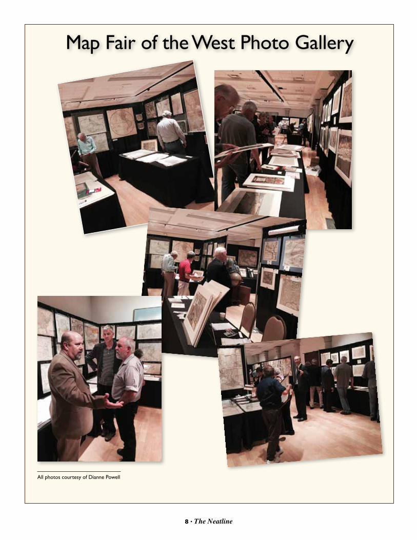
Map Fair of the West Photo Gallery
All photos courtesy of Dianne Powell

9 • The Neatline
MY FAvORITE MAP by Matt Walter
If you would like to submit an article about your own favorite map for a future issue of The Neatline, contact the editor David Finfrock at [email protected].
My favorite map is currently Ferdinand Roemer’s 1849 Topographisch-geognostiche Karte von Texas. Published as part of his book Texas, the map was the first geology map of the Lone Star State. In 1845, Roemer – who had received his PhD in Paleontology in 1842 from the University of Berlin – was hired by Prince Carl of Solms-Braunfels to travel to Texas, conduct a survey of a region of land known as the Fisher-Miller Land Grant, and then report back to the Prince. The Fisher-Miller Land Grant was an area of around 5,000 square miles between the Llano and Colorado River that had been issued to Henry Fisher and Burchard Miller by the Republic of Texas on 7 June 1842; in exchange, the two men agreed to settle 600 immigrant families and 400 single men, of German, Dutch, Swiss, Danish, Swedish, and Norwegian ancestry within the next three years. When they were unable to meet the terms of their grant, the land was then sold to the Adelsverein – the Society for the Protection of German Immigration – which was headed by Prince Carl, who then hired and dispatched Ferdinand Roemer to find out what the society had just bought.
Roemer arrived in Galveston in late November 1845, finding a Texas that was eagerly anticipating their upcoming annexation by the United States the following month. From there, he proceeded up Galveston Bay to Houston and then set off, on foot and wagon, for the German settlement of New Braunfels, a trip that took nearly a month to complete. He fell in love with the New Braunfels area and, with biologist Ferdinand Lindheimer as his guide, Roemer spent the spring and summer exploring the Hill Country of Texas. He also visited San Antonio, Bastrop, and Austin, noting that “a more beautiful and pleasant [location] could not have been selected” for
the capital city of the state. In the fall, Roemer explored eastward and may have even reached the Sabine River.
One year after reaching New Braunfels, Roemer made the trip to Fredericksburg, which Prince Carl had recommended as his base of operations. In February 1847, Roemer finally set out to complete his mission of exploring the Fisher-Miller Land Grant. As the area was still generally under control of the Comanche Indians, the exploring party consisted of 17 well-armed men including a couple of Delaware Indians, three Shawnee Indians, and two Mexican muleteers. Their encounters with the Comanche proved to be peaceful, giving Roemer about a month to investigate the land. He was able determine that the earlier Spanish reports, which indicated the potential presence of silver ore in the region, were either false or incorrect. Upon completing his survey, Roemer began his long and arduous return trip to Germany, and reported to Prince Carl that the Fisher-Miller Land Grant “was not the proper place for settlement by Germans” (286), due to the low fertility of the ground, its distance from the rest of Texas, and the presence of the Comanche. As part of his report – which will be published as his book Texas in 1849 – Roemer produced a map which today is considered to be the first true geology map of Texas.
In 2014, the Museum of the Big Bend received a donation of the Roemer 1849 map from Yana and Marty Davis. It has proven to be quite popular and has been used in a presentation at the Sul Ross Geology Club, as the subject of a paper present at the annual Center for Big Bend Studies Conference on 8 Nov 2014, and at various other venues in the Big Bend region of Texas. In the future, it will be the centerpiece of a map exhibit on the Geology of Texas at the Museum of the Big Bend.
See map on page 10
Topographisch-geognostiche Karte von TexasFerdinand Roemer, 1849
Matt Walter is the Curator of Collections, Museum of the Big Bend, Alpine, Texas.

10 • The Neatline
My Favorite Map continued from page 9
10 • The Neatline 11 • The Neatline
A Summary of the Frank and Carol Holcomb Map Collection of American Maps Focusing on TexasBy: Frank Holcomb
Most map collections exhibited in Texas focus on nineteenth century maps of Texas. When we started collecting maps in 1978, we focused on the Americas prior to 1600 showing the earliest depictions of what became Texas. These maps generally were decorated with sea monsters and many had color similar to illuminated manuscripts.
Eventually we expanded the time period to include over seventy maps of the Americas from 1513 to 1904 with an emphasis on original color. Although the majority of our maps are of North America, they all include Texas. No map in our collection limits North America to east of the Mississippi and they all illustrate exploration and westward expansion.
Our first exhibit was titled “The United States & Texas Too” at the San Jacinto Patron’s Party in April 2013, and it showed nineteenth century maps.
At a Texas Map Society meeting in Waco in 2014 we learned about the Texas General Land Office (GLO) program to digitize public and private collections. We gave the GLO access to our maps for digitization while retaining ownership, for now, of the originals. The GLO prints and sells reproductions of our collection and of its 45,000 maps in the same size and color as the original to fund its Save Texas History program. The proceeds are dedicated to the conservation and preservation of the GLO’s maps and documents that, among other things, encourage the study of Texas history by providing resources for teachers, genealogists, and historians. All maps in the collection can be viewed online at http://www.glo.texas.gov/cf/ArcMaps/ArcMapsLookup.cfm.
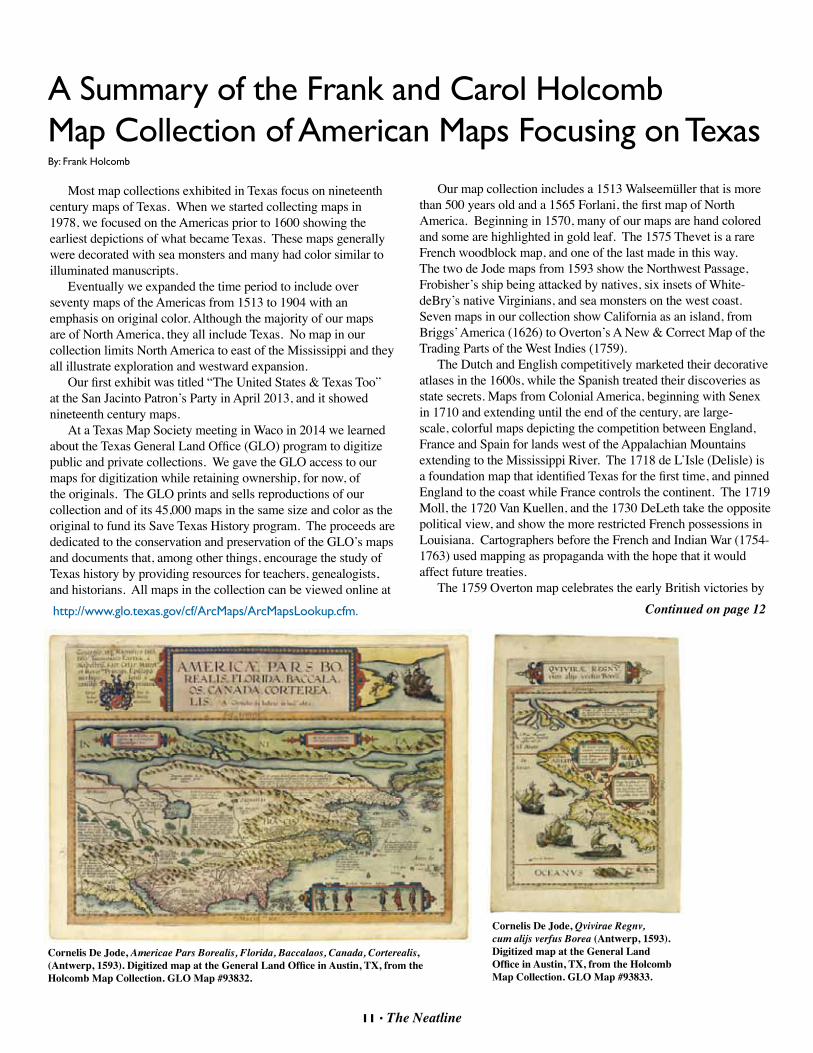
Our map collection includes a 1513 Walseemüller that is more than 500 years old and a 1565 Forlani, the first map of North America. Beginning in 1570, many of our maps are hand colored and some are highlighted in gold leaf. The 1575 Thevet is a rare French woodblock map, and one of the last made in this way. The two de Jode maps from 1593 show the Northwest Passage, Frobisher’s ship being attacked by natives, six insets of White-deBry’s native Virginians, and sea monsters on the west coast. Seven maps in our collection show California as an island, from Briggs’ America (1626) to Overton’s A New & Correct Map of the Trading Parts of the West Indies (1759).
The Dutch and English competitively marketed their decorative atlases in the 1600s, while the Spanish treated their discoveries as state secrets. Maps from Colonial America, beginning with Senex in 1710 and extending until the end of the century, are large-scale, colorful maps depicting the competition between England, France and Spain for lands west of the Appalachian Mountains extending to the Mississippi River. The 1718 de L’Isle (Delisle) is a foundation map that identified Texas for the first time, and pinned England to the coast while France controls the continent. The 1719 Moll, the 1720 Van Kuellen, and the 1730 DeLeth take the opposite political view, and show the more restricted French possessions in Louisiana. Cartographers before the French and Indian War (1754-1763) used mapping as propaganda with the hope that it would affect future treaties.
The 1759 Overton map celebrates the early British victories by Continued on page 12
Cornelis De Jode, Qvivirae Regnv, cum alijs verfus Borea (Antwerp, 1593). Digitized map at the General Land Office in Austin, TX, from the Holcomb Map Collection. GLO Map #93833.
Cornelis De Jode, Americae Pars Borealis, Florida, Baccalaos, Canada, Corterealis, (Antwerp, 1593). Digitized map at the General Land Office in Austin, TX, from the Holcomb Map Collection. GLO Map #93832.

Holcomb Map Collection continued
12 • The Neatline
Editor’s Note:James Harkin, Director of Public Services at the General Land Office in Austin issued a press release on the digitization of the Frank & Carol Holcomb Map Collection. Click this link for a PDF: http://www.glo.texas.gov/glo_news/press_releases/2014/november/save-texas-history.pdf Also, the public can access these maps online at http://www.glo.texas.gov/save-texas-history/gifts.html and even purchase copies of the maps.
Admiral Edward Vernon over the Spanish in the War of Jenkin’s Ear (1739-1748). It contains ten panels, some of which include harbor views of major ports and naval battles in North America. The War of Jenkins Ear was a trade war in which American colonists for the first time served under the British. Lawrence Washington was so impressed with the success of his naval commander that he named his plantation Mount Vernon. George Washington later acquired the plantation from his half-brother’s estate. Our 1759 map replaced the portrait of Vernon with that of Admiral Edward Boscawen, a later naval hero in the war. There are no other known examples of the Overton map dedicated to Boscawen, and there are few examples of any ten panel Overton map.
The large 1763 Bowles map of America exists in only a few examples (see Library of Congress). The map shows the extent of the British Empire following its victory in the French and Indian War. The map was owned by Doris Duke’s first husband, James H. R. Cromwell, who was US Ambassador to Canada in 1940. The eighteenth century collection ends with the large 1784 Lotter showing the Thirteen Provinces of the United States of North America.
American mapping began commercially in the nineteenth century. The earliest example in this collection is a 1818 Melish published in Philadelphia showing America from the Atlantic to the Pacific. This map is about five feet by three feet. After Melish, Tanner was the next great American cartographer, producing maps in what is referred to by collectors as “the treaty series” leading to the end of the Mexican War in 1848. Tanner’s large 1822 map of North America and a map of Mexico showing Texas in 1846 during the Mexican War are part of this collection. The 1828 White, Gallagher, and White is my favorite in the treaty series because of its rarity and color. The treaty series ends with the 1847 Disturnell, a version of which was used for the treaty with Mexico in which the U.S. seized one-third of Mexico.
A very colorful example of “Gen’l Austin’s Map of Texas” (1840) published by Tanner is a major item in the collection. Frances Moore, the first Mayor of Houston, wrote the accompanying book titled “Map and Description of Texas”, which includes the earliest print of the Alamo four years after the battle and seven other prints. Our Burr map of Texas is dated 1845. The original owner was a German investor living in New York who engaged in Texas land speculation, as indicated by certain markings showing German settlements not yet recorded on the map and the targeted area for colonization. Original land grant documents were included with the map, which can be examined on the GLO website. The Colorado and Red River map of 1835, printed in New York, shows Texas land companies before the Texas revolution. This is one of the rarest maps of Texas, more so than the Austin and Burr maps.
The collection includes the earliest large-scale railroad map of
Texas. The French promotional map of 1857 includes projected railways in Galveston and Harris County before the Civil War. This is the only example that I know exists.
Included in the collection are the Hunt and Randel from 1839 and Pressler’s 1867 Travelers Map of Texas. The collection also includes an 1844 Emory issued to General Brooke with his name on the pocket in which the map was issued. General Brooke was in charge of supplying troops to Generals Taylor and Scott from New Orleans during the Mexican War.
The only Houston map in the collection is the bird’s eye from 1873. There are few existing examples of this map. The only Spanish map of Texas is the Alzate y Ramirez from 1766 which was published in France.
We have not approached our map collection as historians, or as collectors assembling large volumes of maps and atlases. Our collection consists of a few maps that are framed to be displayed showing in the most attractive form the art of mapping America with Texas as the focal point.
We are excited that the GLO has made these images available to the public.
Richard S. Hunt, Jesse F. Randel, Map of Texas, compiled from surveys on record in the General Land Office of the Republic (New York, J. H. Colton, 1839). Digitized map at the General Land Office in Austin, TX, from the Holcomb Map Collection. GLO map #93858.

Collection of Cuban Maps Now OnlineBy David Finfrock
With the ongoing thaw in relations between the United States and Cuba, interest in travel to that island nation is rapidly increasing. Many US citizens are wanting to learn more about the history and geography of Cuba.
Drawing from the Cuban Heritage Collection’s holdings, the University of Miami’s libraries are now hosting a digital collection of over 100 maps of Cuba, ranging from the 16th century through the early 20th century. You can view them all at this website:
http://library.miami.edu/chc/2015/02/03/new-digital-collection-of-maps-of-cuba-pre-1923/
Our thanks to Mitch Stepanovich for alerting us to this new collection.
Plano de La Habana, Estéban T. Pichardo, Office of Chief Engineer, City of Havana, 1900From the Cuban Heritage Collection at the University of Miami Libraries
Exploring Maps with GIS By David Finfrock
TMS member George Daily is a demographer and rural sociologist by training, and an educator and information specialist by trade. For over two decades, George has been part of Environmental Systems Research Institute (ESRI), as a member of the Education Program team. George and his colleagues are working to bring GIS technology into K-16 education.
George recently alerted us to a new “Hidden History” map viewer available from the General Land Office. The GLO has about 45,000 historical maps and have published about 25 here: http://www.glo.texas.gov/texas-hidden-history/index.php
Load any of those historical maps, and it will place them into modern context. I chose the Austin Colony map, and was able to view the old land grants of the Millican family, my wife’s progenitors and among Austin’s “Old 300” settlers. I was able to view the location of the land grants, and at the same time place them in context on the modern map. When you investigate one of the maps, just be sure to zoom in enough to see the details in the map viewer.
George also pointed out a separate source for “Story Maps”. Here’s a link to a number of other maps that leverage some of David Rumsey’s collection, exploring key US cities by GIS: http://storymaps.arcgis.com/en/gallery/#s=0&n=30&d=1&q=rumsey
13 • The Neatline
Map ProjectionsBy David Finfrock
Last fall, our friends at Wired Magazine published an excellent article on map projections. In particular, the author Nick Stockton discussed in detail the geometry and general usefulness of the azimuthal orthographic projection. You can read the entire article at:http://www.wired.com/2014/11/get-to-know-a-projection-azimuthal-orthographic/
Mr. Stockton was eager to point out one of his sources for the article: a Brazilian cartographer named Carlos Furuti, who maintains an excellent website on the science and application of all kinds of map projections at:http://www.progonos.com/furuti/MapProj/Normal/TOC/cartTOC.html
2014 Ristow PrizeThe Washington Map Society is
pleased to announce that David Fedman, a PhD. candidate in history at Stanford University, has been selected as the winner of the 2014 Ristow Prize in the history of cartography. His paper, entitled “Mapping Armageddon” The Cartography of Ruin in Occupied Japan,” will appear in a forthcoming issue of The Portolan. Anouk Vermeulen, a PhD. candidate in the School of Classics at St. Andrews University in Scotland, received Honorable Mention for her essay, “Landscapes in Stone and Bronze: A New Interpretatin of Four Monumental Formae.”
The 2015 competition for the Ristow Prize is now open for applicants. Full- or part-time undergraduate, graduate, or first-year postgraduate students attending any accredited college or university worldwide are eligible to submit papers. Submissions are due June 1, 2015, and should be sent to Dr. Evelyn Edson, 268 Springtree Lane, Scottsville, VA 24590, USA Visit the Washington Map Society home page: http://www.washmapsociety.org, and click on “Ristow Prize, or send inquiries to [email protected].

14 • The Neatline
Please help us keep our signals straight! Send updates of your contact information (email address & physical address) to [email protected] or to
Ben HusemanSecretary, Texas Map Societyc/o Cartographic ArchivistUT Arlington Library Special Collections • Box 19497702 Planetarium PlaceArlington, Texas 76019-0497 Phone: 817 272-0633 • FAX: 817 272-3360
TMS Officers and Board MembersOFFICERS
BOARd MEMBERS (Jan 2015 - dec 2017)
UNELECTEd OFFICERSEditor, The NeatlineDavid FinfrockCedar Hill, [email protected]
Website ManagerMax GrossDallas, [email protected]
President Shirley ApplewhiteJan 2015 - Dec 2016 Fort Worth, [email protected]
First vice President David MurphJan 2015 - Dec 2016Grapevine, [email protected]
Second vice PresidentDr. Russell MartinJan 2015 - Dec 2016Dallas, [email protected]
Secretary Ben HusemanJan 2015 - Dec 2016Arlington, [email protected]
Treasurer Lynne StarnesJan 2015 - Dec 2016Dallas, TX [email protected]
John PhillipsStillwater, [email protected]
Pamalla AndersonDallas, [email protected]
John WilsonWaco, [email protected]
David FinfrockCedar Hill, [email protected]
BOARd MEMBERS (Jan 2014 - dec 2016)
Brenda McClurkinWeatherford, [email protected]
Stephanie MillerArlington, [email protected]
Bill StallingsIrving, [email protected]
Walt WilsonSan Antonio, [email protected]
SAvE THE dATEFuture Meetings of the Texas Map Society
Fall 2015 TMS Meeting October 2-3, 2015
University of Texas at Arlington Library
Spring 2016 TMS Meeting April 1-2, 2016
University of Texas at Corpus Christi
Fall 2016 TMS Meeting and the 10th Biennial
Virginia Garrett Lectures October 6-9, 2016
University of Texas at Arlington Library