it port report
TRANSCRIPT
1
1. INTRODUCTION
To fulfill the industrial training programme, I have visted Visakhapatnam
port trust, as it is one of the major ports in India with large scale of exports
and imports takeing place every year. Civil engineering works have a lot of
scope in ports, hence i choose it. Ports are necessaey for economical growth
of a country. Hence development of port is more important
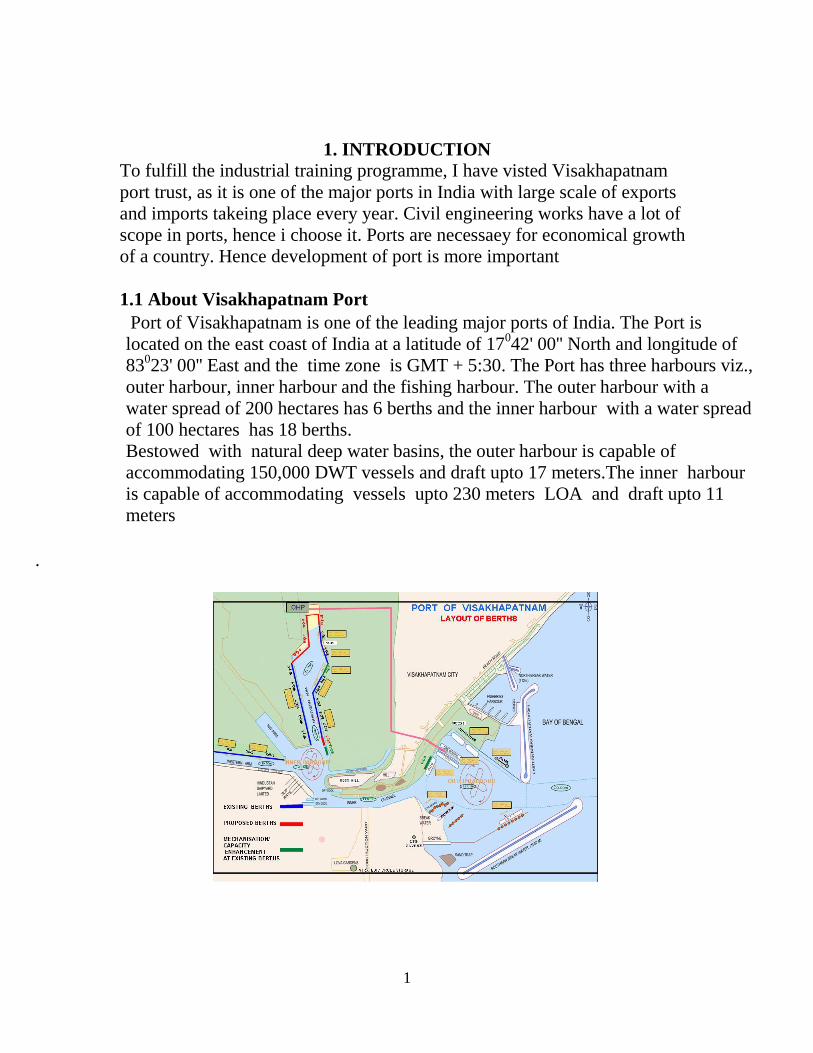
1.1 About Visakhapatnam Port
Port of Visakhapatnam is one of the leading major ports of India. The Port is
located on the east coast of India at a latitude of 17042' 00'' North and longitude of
83023' 00'' East and the time zone is GMT + 5:30. The Port has three harbours viz.,
outer harbour, inner harbour and the fishing harbour. The outer harbour with a
water spread of 200 hectares has 6 berths and the inner harbour with a water spread
of 100 hectares has 18 berths.
Bestowed with natural deep water basins, the outer harbour is capable of
accommodating 150,000 DWT vessels and draft upto 17 meters.The inner harbour
is capable of accommodating vessels upto 230 meters LOA and draft upto 11
meters
.

2
1.2 Role of Port
A catalyst for industrial and economic development
A force multiplier of economy
A facilitator for foreign exchange earning
A promoter of export trade being cheapest mode of transport
An interface between sea and land
A multi-facet entity where all modes of transport converges
1.3 Port Infrastructure
The Port has three harbours viz., outer harbour, inner harbour and the fishing
harbour. The outer harbour with a water spread of 200 hectares has 6 berths and the
inner harbour with a water spread of 100 hectares has 18 berths. Bestowed with
natural deep water basins, the outer harbour is capable of accommodating 150,000
DWT vessels and draft up to 17 meters. The inner harbour berths are PANAMAX
compatible and are capable of accommodating vessels up to 230 meters LOA and
draft upto 11 meters. The Port is catering to the key industries like the petroleum,
steel, power and fertilizers besides other manufacturing industries and playing
catalyst role for the agricultural and industrial development of its hinterland
spreading from the south to the north. During the FY 201011 the Port handled a
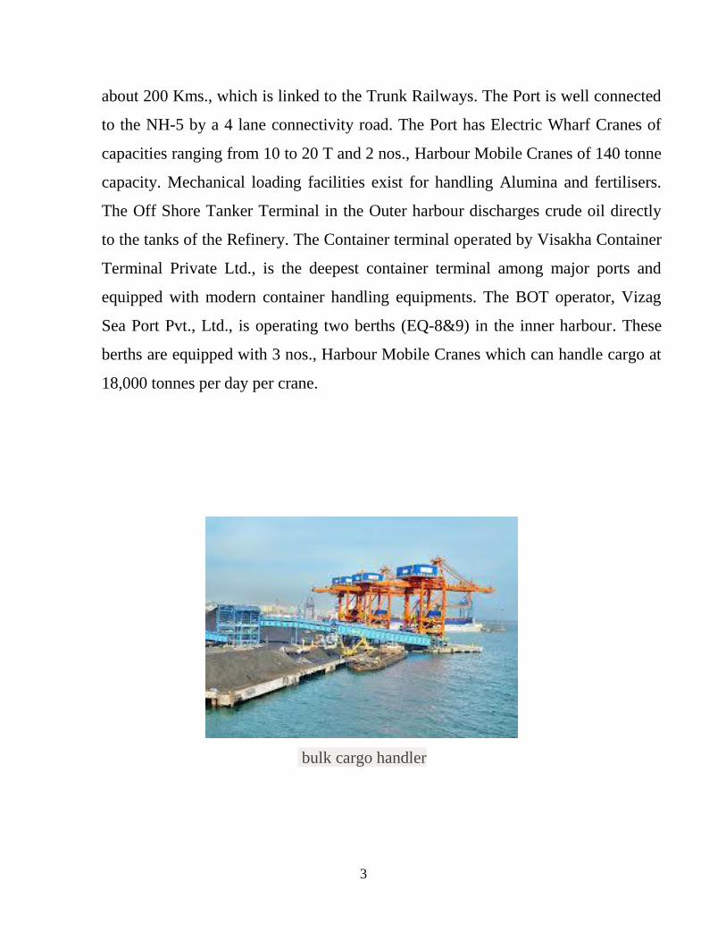
record quantity of 68.01 million tones of cargo. The Port is equipped with an array
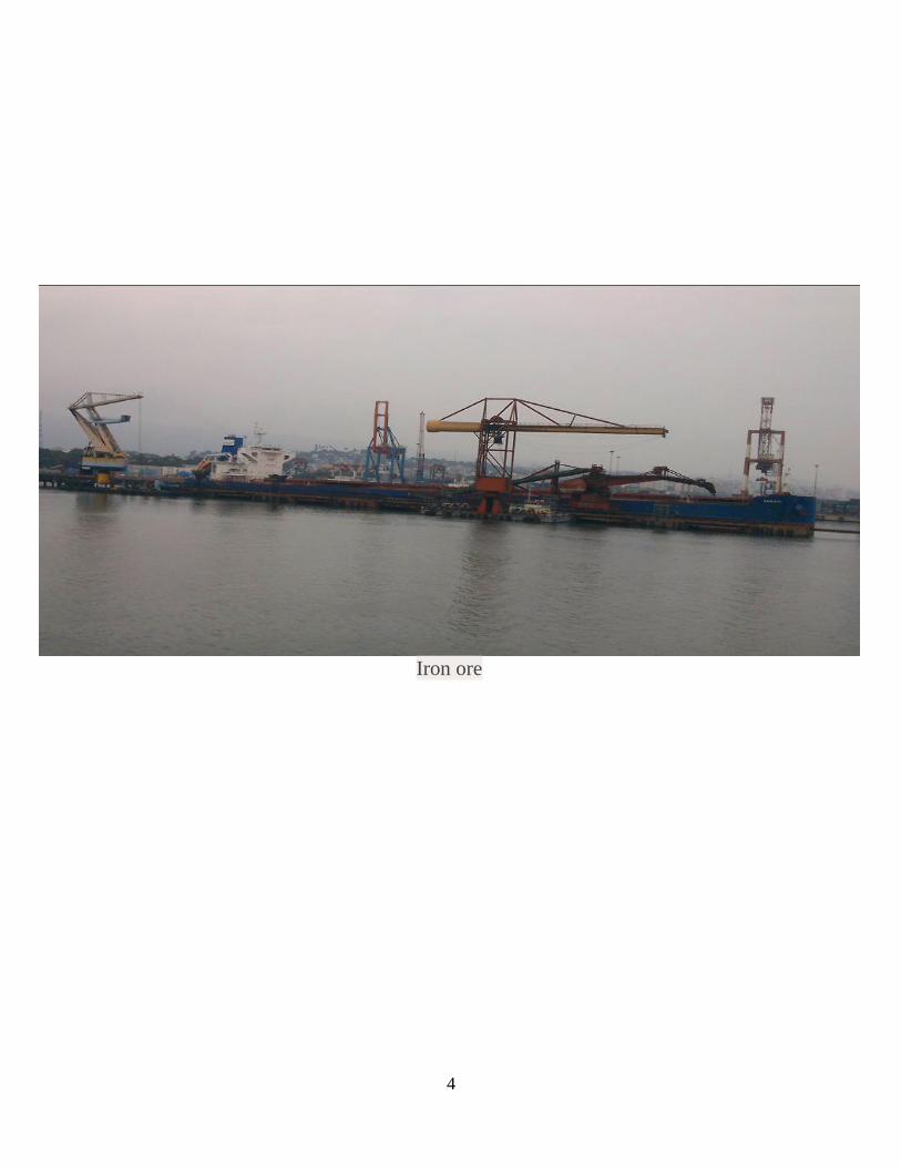
of cargo transfer systems. The mechanical ore handling plant consists of fully
mechanized receiving and shipping systems designed to loads iron ore directly into
the vessels through conveyors. The Port is operating its own Railway network of
3
about 200 Kms., which is linked to the Trunk Railways. The Port is well connected
to the NH5 by a 4 lane connectivity road. The Port has Electric Wharf Cranes of
capacities ranging from 10 to 20 T and 2 nos., Harbour Mobile Cranes of 140 tonne
capacity. Mechanical loading facilities exist for handling Alumina and fertilisers.
The Off Shore Tanker Terminal in the Outer harbour discharges crude oil directly
to the tanks of the Refinery. The Container terminal operated by Visakha Container
Terminal Private Ltd., is the deepest container terminal among major ports and
equipped with modern container handling equipments. The BOT operator, Vizag
Sea Port Pvt., Ltd., is operating two berths (EQ8&9) in the inner harbour. These
berths are equipped with 3 nos., Harbour Mobile Cranes which can handle cargo at
18,000 tonnes per day per crane.
bulk cargo handler
4
Iron ore

5
MARINE WORKS –II Division
* * *
2.1Introduction
East Quay
The port of Visakhapatnam’s East Quay has a total of 1849 meters of berths.
East Quay berths 1-4 have maximum permissible drafts of 10.06 meters.
Berths 1-3 are each 167.6 meters long, and Berth 4 is 231 meters long. East
Quay 5 is 167.6 meters long; East Quay 6 is 182.9 meters long. Both berths
have maximum permissible draft of 10.21 meters. East Quay Berths 7-9 are
each 255 meters long with maximum permissible draft of 11 meters.
West Quay
In the west side of the Inner Harbour, the West Quay has a total of 1294
meters in six berths. West Quays 1-5 all have maximum permissible beam of
32.5 meters and maximum permissible drafts of 11 meters. Quay 1 is 212
meters long, Quay 2 is 226.7 meters long, Quay 3 is 201.1 meters long,
Quay 4 is 243 meters long, and Quay 5 is 241.7 meters long. RE WQ-1
Berth in the inner Harbour is 170 meters long and has maximum permissible
beam of 25 meters and maximum permissible drafts of 8 meters.
North West Arm
The port of Visakhapatnam’s north western Arm in the inner harbour
contains three berths. The fertilizer berth is 173.1 meters long with
maximum permissible beam of 32.5 meters and maximum permissible draft
of 10.06 meters. The two oil refinery berths are each 183 meters long with
maximum permissible draft of 32.5 meters. Oil Refinery Berth 1 has
maximum permissible of 10.06 meters, and Oil refinery berth 2 has
maximum permissible draft of 9.75 meters.
Period of training: 7th
June 2013 to 13th
June 2013
There are 3 sub-divisions in this division
i. AE (SLCJ) ii. AE (DR) & iii. AE (Environmental)
6
As per the directions of Executive Engineer, first we have under gone
training at SLCJ sub-division, then Dredging and lastly at Environmental
sub-division.
2.2. SL Canal Jetty sub-division:
Name of the project: Relocation of jetties/facilities for Tugs/Harbour
crafts along the north and south sides of SL Canal
for development of EQ-1A berth
ESTIMATED COST : Rs 32,02,69,300/-
PERIOD: 12 MONTHS
Scope of Work
Existing Tug-tie up jetty constructed for anchoring tugs/harbour crafts on
west of marine complex near inner harbour turning circle. As the cargo
handling increased copiously over the years, there is step up in no of
tugs/harbour crafts necessary to convey the cargo ships in to the harbour.
So, there is a necessity for extension of the existing EQ-1A berth. It is done
by constructing two rows of piles along the marine and land side of northern
arm of SL canal jetty. A new 7 meter wide road is proposed for traffic
management on southern side of SL canal and slope protection for the road
is done by constructing a retaining wall on the bank.
Capital dredging is done to -7.00 meters in the canal for hindered free
movement of tugs. A T-shaped diaphragm wall is constructed for protection
of foundation VIP launch as capital dredging may endanger its sub structure.
Dredging and construction of jetty are the immediate requirements and
should be completed on priority.
7
Process
1. Providing two rows of 1000mm cast in situ vertical bored M30 piles at
5.79 meters c/c on land and sea side.
2. Piles in each row are at a c/c distance of 5.00 meters.
3. Providing pile cap of depth 1150mm on sea side and 600mm depth pile
cap on land side.
4. Capping beam of 2175mm wide is provided on piles on both land and
marine side. Two rows of piles are connected with a beam with 50mm
thick expansion joints at 31.85 meters c/c.
5. Construction of guide wall for laying T-shaped panels for diaphragm
wall.
6. Laying 3000mm wide flanged T-shaped panels, 17 in number with pre
cast stop ends between them.
7. Providing R.C.C M30 capping beam 1500mm*1500mm on diaphragm
wall.
8. Providing a new road of 7.00 meters wide with hot bituminous
macadam etc.,
9. Construction of retaining wall on southern side of SL canal with R.C.C
M30 1200mm diameter piles.
10. Dredging in SL canal up to (-) 7.00 meters.
11. Providing and fixing marine fixtures such as super arch fenders,
bollards, anchor bolts, mooring rings, and moulded rubber ladders.
12. Providing gabion mattress, rock filling on both sides of SL canal if
necessary.
8
2.3Dredging Sub-division
Scope of work:- Deepening the inner harbour channel and inner harbor
turning circle up to (-) 16.10m capital dredging to accommodate 14m draft
vessels at Visakhapatnam port
Estimated contract value : Rs.217.27Cr.
Period of completion : 12 months
INTRODUCTION: The port of Visakhapatnam is located in
Latitude:17’41’N and Longitude:-83’18’E. The port is located almost
midway between Kolkata and Chennai on the east coast of India.
The port comprises of
- Inner harbor with 18 berths and
- Outer harbor with 7 berths and 1 mooring berth.
The project site is located in the inner harbor channel and inner harbor
turning circle of port of Visakhapatnam.
Dredging is an excavation activity or operation usually carried out at least
partly underwater, in shallow seas or fresh water areas with the purpose of
gathering up bottom sediments and disposing of them at a different location.
This technique is often used to keep waterways navigable.
It is also used as a way to replenish sand on some public beaches, where
sand has been lost because of coastal erosion. Dredging is also used as a
technique for fishing for certain species of edible clams and crabs,
see fishing dredge.

9
A dredger is any device, machine, or vessel that is used to excavate and
remove material from the bottom of a body of water. For example, a scoop
attached to the end of a rope or pole by which a man can draw sediments up
from the bottom of a pond is a dredger. Developing this idea further, a
motorized crane equipped with a drag bucket or clamshell (grabber) that is
used to scoop material from the bottom of a body of water is also a dredger.
The crane could be located on the bank, or perhaps mounted on a barge. If
the crane is mounted on a barge, the entire vessel is referred to as a dredger
The process of dredging creates spoils (excess material), which are carried
away from the dredged area. Dredging can produce materials for land
reclamation or other purposes (usually construction-related), and has also
historically played a significant role in gold mining. Dredging can create
disturbance in aquatic ecosystems, often with adverse impacts.
Dredging can be classified into two types. Capital dredging and maintenance
dredging
Capital: dredging carried out to create a new harbour, berth or waterway, or
to deepen existing facilities in order to allow larger ships access. Because
capital works usually involve hard material or high-volume works, the work
is usually done using a cutter suction dredge or large trailing suction hopper
dredge; but for rock works, drilling and blasting along with mechanical
excavation may be used.
Maintenance:
dredging to deepen or maintain navigable waterways or channels which are
threatened to become silted with the passage of time, due to sedimented sand
and mud, possibly making them too shallow for navigation. This is often
carried out with a trailing suction hopper dredger. Most dredging is for this

10
purpose, and it may also be done to maintain the holding capacity of
reservoirs or lakes.
A trailing suction hopper dredger (TSHD) trails its suction pipe when
working, and loads the dredge spoil into one or more hoppers in the vessel.
When the hoppers are full, the TSHD sails to a disposal area and either
dumps the material through doors in the hull or pumps the material out of
the hoppers. Some dredges also self-offload using drag buckets and
conveyors.
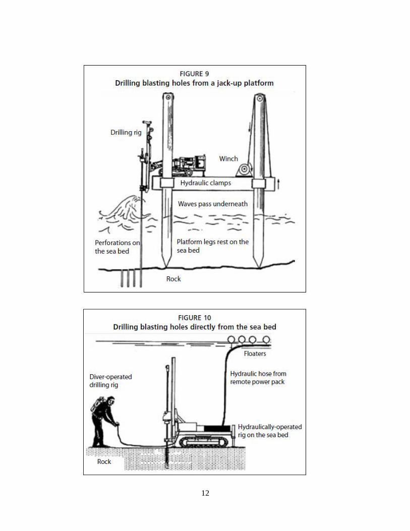
Blasting
Blasting is a relatively quick method for dealing with small amounts of very
hard rock formations like outcrops. Large quantities of hard rock are
nowadays excavated by rock-cutter suction dredgers or bucket dredgers.
The disadvantages are:

11
• The blasting must be accompanied by grabbing for the removal of the
spoil;
• Unless carried out from the sea bed, both drilling and grabbing cause an
obstruction to sea traffic;
• The indiscriminate loss of sea life during blasting;
• The percentage of fines generated by the fragmentation of coralline rock
are very hard to predict; and
• Mobilization costs can be considerable
12

13
Disposal of materials:-In a "hopper dredger", the dredged materials end up
in a large onboard hold called a "hopper." A suction hopper dredger is
usually used for maintenance dredging. A hopper dredger usually has doors
in its bottom to empty the dredged materials. As the vessel dredges, excess
water in the dredged materials is spilled off as the heavier solids settle to the
bottom of the hopper. This excess water is returned to the sea to reduce
weight and increase the amount of solid material (or slurry) that can be
carried in one load. When the hopper is filled with slurry, the dredger stops
dredging and goes to a dump site and empties its hopper.
Terms and definitions:-
Land reclamation: dredging to mine sand, clay or rock from the seabed and
using it to construct new land elsewhere. This is typically performed by a
cutter-suction dredge or trailing suction hopper dredge. The material may
also be used for flood or erosion control.
Beach nourishment: mining sand offshore and placing on a beach to
replace sand eroded by storms or wave action. This is done to enhance the
recreational and protective function of the beaches, which can be eroded by
human activity or by storms. This is typically performed by a cutter-suction
dredge or trailing suction hopper dredge.
In the present Ph-III dredging in Visakhapatnam Port, the dredging is to be
carried out both in soft/hard strata and disposed of at designated dumping
ground. Dredging is to be carried out in hard strata, comprising sheet rock of
predominantly Khondalite origin, sometimes weathered and fractured. The
rock is overlain by overburden materials like clay, silt, sand, and gravel.

14
Type of vessel used is trailer suction hopper dredger. The detail of the
dredger is mentioned below:
Built 2007 (China) Flag/Class Belize / Indian Register
of Shipping
Deadweight 6,920 MT LOA /Beam) 96.78 / 18.00
Hopper
Capacity
4,500 Cu.m GT / NT 4,337 / 1,301
Sea Speed /
Con
10.5k on 19.5
MT MGO Total Installed
Diesel Power
7824 kW
Draught
Loaded
7.03 m Maximum
Dredging Depth
25 m
CALCUALTIION OF QUANTITIES:
Accurate quantity estimates are important for the choice of dredging plant,
production estimates, time of execution and ultimately project costs.
Expressed in quantities, a dredging operation can extend from a few hundred
cubic metres to many millions of cubic metrics. In order to arrive at an
accurate dredging volume, the following is required:
1. A detailed design layout showing areas to be dredged and the design
depths required together with the relevant cross-sections;
2. A hydrographic survey of the area with bathymetric contours at 1 metre
intervals for extensive projects or hydrographic grid with bathymetric
contours at 0.25 metre interval for isolated structures

15
3. A geotechnical survey including borehole logs, in-situ and laboratory
test results and samples.
The factors to be taken before going into procedure of dredging:-
i) The depth of the sea bed
ii) Nature of soil present in the sea bed
i) DEPTH OF THE SEA BED:-Before the works of any part thereof
begun, the contractor’s agent ,the engineer’s representative shall
together survey and take levels of the site of the works both above and
below water level/chart datum level. Each hydrographic survey shall
be carried out using a high frequency .single beam echo sounder,
which shall be capable of sounding with accuracy to within one
percent(1%) of the depth in conjunction with position fixing using
Real Time Differential GPS. The interfacing of the GPS and Echo
sounder will be done by “HYPACK-MAX” or equivalent standard
software acceptable to engineer. The plan of survey area and the cross
sections to be surveyed shall be continuously displayed on the
computer monitor installed in the survey vessel.
ii) NATURE OF THE SEA BED: Visakhapatnam port trust has
proposed to widening and deepening of inner channel and IHTC to
bring bigger draft vessels at port. They entrusted the job of
geotechnical investigation to M/s.VPC Concrete & Geo technologies,
Visakhapatnam, to conduct the necessary field investigations
,laboratory tests through Andhra University on various soil samples
collected .
SCOPE: The scope of this work includes the establishment of profiles and
comparing all the geotechnical test results and analysis of results. These
16
results will be utilized for future widening and deepening of the channel.
Ninety boreholes were conducted in the proposed channel area.
The scope of soil investigation includes exploration of subsoil using 150mm
diameter boring and NX size coring in rock formation .It includes
conducting various field tests, collection of samples from the field and
conducting various laboratory tests, and analyzing the results. The field tests
conducted includes standard penetration tests at required depths. The field
work also includes collection of disturbed samples from all the boreholes at
suitable depths. The samples collected from the field are subjected to various
laboratory tests including atterberg limits, grain size analysis ,specific
gravity etc, in each bore. The
Results of laboratory and field investigations are used for proper
classification of soil and to determine the strength parameters of various
soils. Jet probing in IHC and IHTC at 20mts.Grid to identify the rock level.
FIELD INVESTIGATIONS:-
Actual field investigations were carried out by using power driven
mechanical auger and wash water with the help of hydraulically operated
Jack up platform. In this method ,water was forced under pressure through
an inner tube, which is retained inside a casing pipe. The slurry flowing out
gives an indication of the soil type. The entire boring operating operation
was conducted in accordance with provisions laid down in IS: 1892-1962.
The diameter of the borehole was 150mm and casing was to support the
walls of the borehole.
Standard penetration tests (SPT) were conducted at required depth intervals
in each borehole, throughout the depth of exploration. The SPT was
conducted by driving a split spoon sampler under the blows of 63.5 kg

17
weight with a 75cm free fall. The initial 15m penetration was taken as the
seating drive. The number of blows required to drive the sample 30cm
beyond the seating drive is taken as the SPT ‘N’ value. All standard
penetration tests are carried out as per provisions in IS: 2131-1963.
Disturbed soil samples were collected at various depths to access the nature
of soil and to evaluate geotechnical properties in the laboratory.
Type of dredger used:-Trailer Suction Hopper Dredger (TSHD)
Procedure:-
i) The dredgers intended for the subject work shall be installed with
position fixing system and dredge pack system so as to position the
vessel accurately in the required dredging area and monitor the depth
of dredging to the required line and level.
ii) Similarly the drilling rig, hopper barges& tugs etc,to be installed with
position fixing system and communication equipment such as walkie
talkies etc .
iii) The dredged material is to be removed from the site of dredging area
and transported and dumped at dumping ground marked as “spoil
grounds” on the navigation chart with Visakhapatnam harbor
published by the chief Hydrographer to Govt.of India.
The dredging is to be carried out to the required line and level as per the
drawings.

18
2.4.Environment monitoring sub-division
The port of Visakhapatnam is accredited with ISO Certification (ISO 14001)
by the Indian Register of Quality Systems for the Environmental
Management System standards in all its activities including related support
services.
An Environmental Monitoring Committee (EMC) headed by renowned
Environmentalist Prof. S. Rama Krishna Rao as Chairman of the
Committee is in place with members representing Citizen Welfare
Associations, NGOs, Academic Institutions, Industries/Defense, Trade, and
Observers from APPCB, Government organizations and Senior Officers of
the Port. The Committee reviews the implementation of long term and a
short term directive issued by APPCB and also reviews the environmental
activities to be implemented by the Port. The Committee also inspects
various operational areas of the Port and advises improvements on the
Environmental activities carried out and gives suggestions for additional
Environmental pollution mitigative measures as may be necessary based on
the requirements from time to time.
Three Sub-Committees are constituted to review and monitor AAQ
(Ambient Air Quality), Green Belt Development and Hazard Management.
The EMC reviews the findings of the Sub-Committees and advises suitably
on the environmental improvement measures.
Environmental cell has been established to monitor the environmental
activities of the Port, duly appointing persons qualified in the field of
Environment Management.
The Visakhapatnam port is presently handling coal at west quay of inner
labour. However due to depth constraints in the inner harbor the largest size

19
vessels of coal are lightened/handled at outer harbor due to availability at
deeper dredge depths in the outer harbor .The coal at GCB is unloaded from
the ships on the wharf using floating cranes and the unloaded cargo is loaded
into the tracks using loaders in the back up area of the berth an at east yard
until it is lifted to the concerned parties
The measures taken by the Port to mitigate Environmental Pollution
include:
• Monitoring of Ambient Air Quality at six locations in and around the Port
area by Port and third parties like Andhra University Development Center
and APPCB.
• Monitoring of harbor water quality at regular intervals through Andhra
University Development Center.
• Monitoring of STP waters before and after treatment at regular intervals.
• Regular monitoring of pollution control measures in and around Port area
and residential areas.
• Preparation of Environmental Management Action Plan and
Comprehensive Environmental zoning and land use plan for all occupied
and unoccupied areas for the next ten years through M/s. MECON, Ranchi.
• Distribution of pamphlets and display of message boards on Environment
Management.
• Development of Environmental Parks/ Nurseries and maintenance of
Islands in and around Port areas.
• Continuous development of Green Belt in and around Port area.
• Mechanization of Cargo Handling Operations in phases.
• Monitoring effluent of Port based industries before discharging into Port
Waters and ensuring that they possess consent of APPCB for their activities.

20
The Port is taking all possible measures to contain the pollution and to
maintain the ambient air quality within permissible limits. In addition to the
above measures, the Port is
(i)Modernizing the cargo handling facilities for coal, iron ore, fertilizers etc.,
(ii)Reorganizing stack yards
(iii)Insulating coal stack yards by providing high rise walls along with dust
suppression system as long term measure to avoid dust pollution.
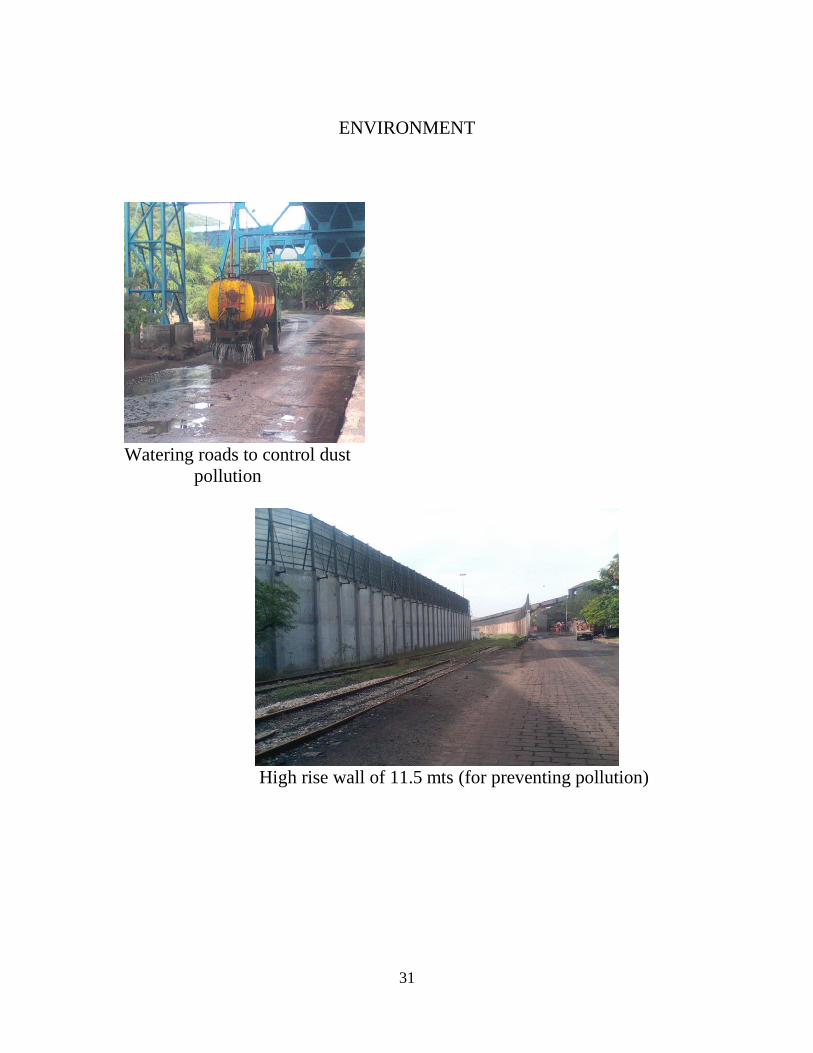
Measures taken by Visakhapatnam Port Trust to control Dust
pollution:
• The coal stock yards at GCB, WOB, North and South of S4 Conveyor are
provided with Mechanical Dust Suppression system at a cost of Rs 8.00
Crores, covering an area of 4,75,000 m2 commissioned in the year 2002 and
the same is effective and water sprinkling is done continuously round the
clock.
• Covering of coal stocks by sprinkling of water and covering with
tarpaulins.
• Watering of roads continuously by water tankers daily.
• Sweeping of roads manually and with other mechanical process.
• The stack heights are limited to thirty meters only.
• Development of green belt around the stack yards and port area.
Beach Nourishment
Visakhapatnam Port Trust is discharging its responsibility as a corporate
citizen in keeping the city clean and green, healthy and aesthetic and
contributing significantly for better civic amenities for the people of
Visakhapatnam.

21
In consonance with the development of Visakhapatnam Outer Harbor in the
early 1970s the need for protection of the beach North of Visakhapatnam
Port from the adverse affect of erosion due to the natural phenomena on
account of sea wave/current action was realized.
A quantity of about 4 lakhs cu. mts. of sand is being pumped for the beach
nourishment every year by incurring an expenditure of about ` 6.00 crores’.
The beach nourishment being carried out for over the last 3 decades shows
the firm commitment of the Port towards the social obligation for the city
public, visitors and fishermen community.

22
MAINTENANCE WORKS
Name of the project: MAINTENANCE OF INNER AND OUTER
HARBOUR WORKS ON BERTHS AND MARINE FIXTURES
Period of training: 14th and 19
thJune 2013
This division deals with various types of berthing structures, marine fixtures.
The maintenance division performs following functions:
The maintenance of structures in outer harbour.
Maintenance of marine fixtures in inner harbour, dry rock and ORS.
Execution of capital dredging and maintenance of break water.
Construction of multi-purpose berth 2 and channel berth.
Maintenance of fishing harbour, SWP way complex.
Marine fixtures
Various marine fixtures on berth are
Bollard
Fenders
Mooring Rings
Ladders
Bollards
Bollards originally referred to short vertical posts, typically found where
large ships dock for mooring. These are used to maintain the vessel to
maintain tranquility. These are used when the vessel arrive the berth for
unloading or loading purpose.

23
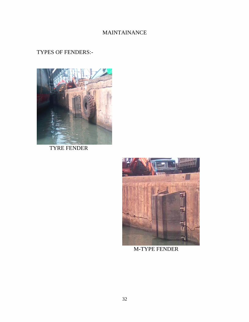
Fenders
In boating, a fender is a bumper used to absorb the kinetic energy of a
berthing boat or vessel against a jetty, quay wall or other vessel. Fenders are
used to prevent damage to boats, vessels and berthing structures. Fenders are
now a day constructed in several ways, typically of rubber, foam elastomer
or plastic. Rubber fenders are either extruded or made in a mould. The type
of fender that is most suitable for an application depends on many variables,
including dimensions and displacement of the vessel, maximum allowable
standoff, berthing structure, tidal variations and other berth-specific
conditions.
Types of fenders:
Super cell fenders
Arch fenders
Cylindrical fenders
M-type fenders
Mooring rings
Mooring rings are used for tying up ropes from berths to get position of ship
in stationary motion. These are available both in mild and steel in different
grades. These rings are used for maneuvering or fastening small boats.
Mooring rings are available from 12mm diameter to 100mm diameter as per
requirement.
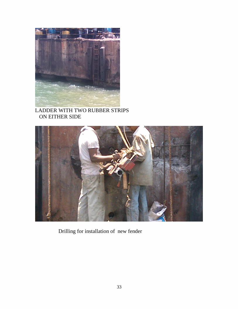
Ladders:
Ladders are used for accessibility from the berths. Ladders are available both
in stainless steel/moulded rubber as per requirement. Unique dual
application ladders are also available, which can be used as fender for small
24
boats as well as ladders. Different types of ladders from 2m length to 12m
length are available as per requirement.
Break waters:
Break waters are structures constructed on coasts defense or to protect an
anchorage from the effects of weather and long shore drift.
Offshore breakwaters also called bulkheads, reduce the intensity of water
action inshore waters and thereby reduce coastal erosion. They are
constructed some distance away from the coast or built with one-end linked
to the coast. The breakwaters may be small structure place one to three
hundred feet offshore in relatively shallow water, designed to protect gently
sloping beach.
There are three breakwaters:
East breakwaters
Southern breakwaters
Northern breakwaters
The length of the east breakwater is 1050m
The length of the south breakwater is 1534m
The length of the north breakwaters is 412m
A minimum depth of 18.2 meters is to maintain in the outer harbor. The
turning radius of outer harbors is 610meters. A minimum depth of 10.7 m is
to maintain in the inner harbor. The turning radius of inner harbor is 440m.
area of the inner channel is 100hectors. Area of the outer harbor is 200
hectors. Length of each berth is 225m.
25
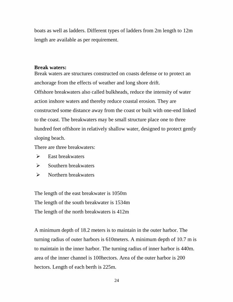
SL NO
NAME OF THE COMPONENT OF STRUCTURE
PARAMETERS TO BE OBSERVED
1 Condition of walls, columns, pillars and staircase
(a) Plastering cracks (b) Structural cracks (c) Exposure of
reinforcement in case of RCC columns & staircase
(d) Pealing of plastering (e) Condition of painting
2 Floor/Roof beams and slabs (a) Leakage/Sweating (b) Surface cracks (c) Structural cracks (d) Exposure of
reinforcement (e) Condition of ceiling
plaster (f) Condition of water
proof treatment (g) Water stagnation
3 ACC sheet roofing walling (a) Leakage (b) Condition of sheets (c) Condition of fixtures
4 Water supply & sanitary fixtures (a) Condition of water closets/ urinals/ wash hand basins
(b) Leakage of pipe joints and valves
(c) Functioning of flushing system
(d) Condition of floor traps
(e) Condition of flooring & skirting
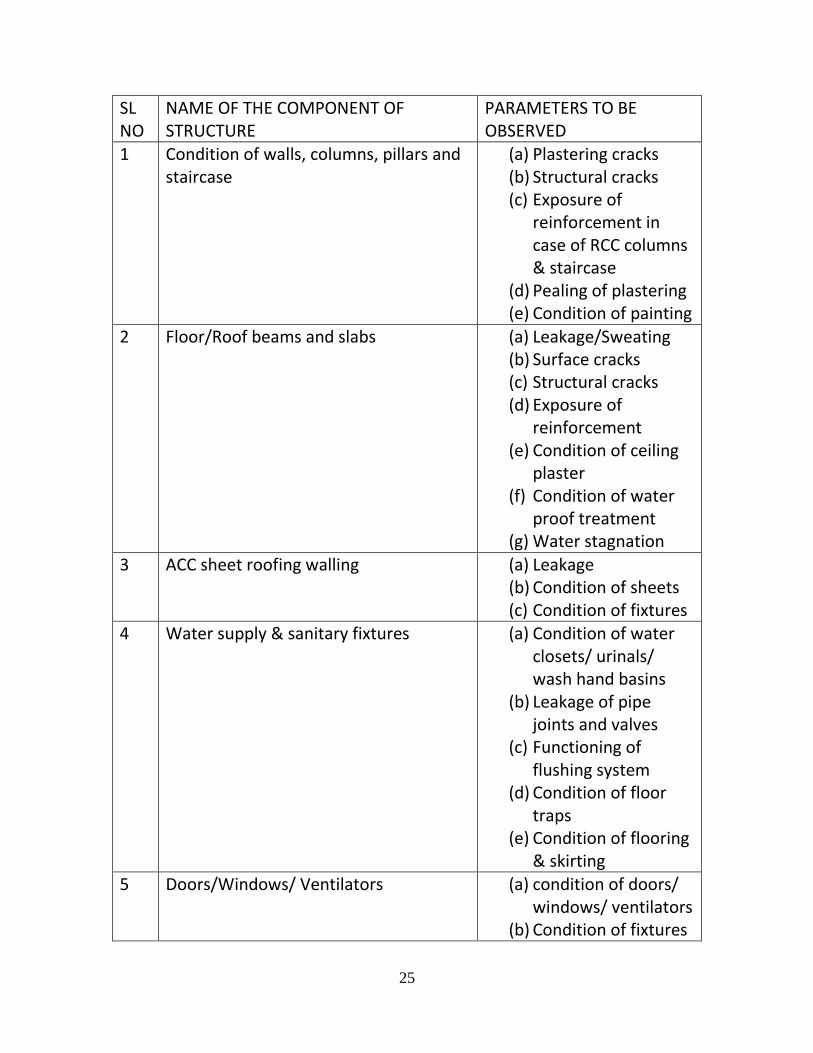
5 Doors/Windows/ Ventilators (a) condition of doors/ windows/ ventilators
(b) Condition of fixtures
26
(c) Damages to glass panes
(d) Condition of ornamental grills
(e) Condition of painting 6 Plinth protection (a) Adequacy of slopes
(b) Damage to plinth protection
7 External Drainage (a) Siltation (b) Adequacy of slopes
(c) Connection to main drain
(d) Cracks in walls
8 Cleanliness of premises (a) Wild growth (b) Garbage
9 Anti termite treatment (a) Termite infection if any
(b) Renewal of treatment
10 Steel roof structures like trusses etc (a) Structural deficiencies like cracks
(b) Conditions of painting
SL NO
Name of component/ structure Functions observed
1 Condition of berthing facing (a) Structural Cracks (b) Exposure of
reinforcement (c) Condition of
kerbwall
2 Condition of kerb (a) Structural cracks (b) Exposure of
reinforcement (c) Condition of kerb
wall
27
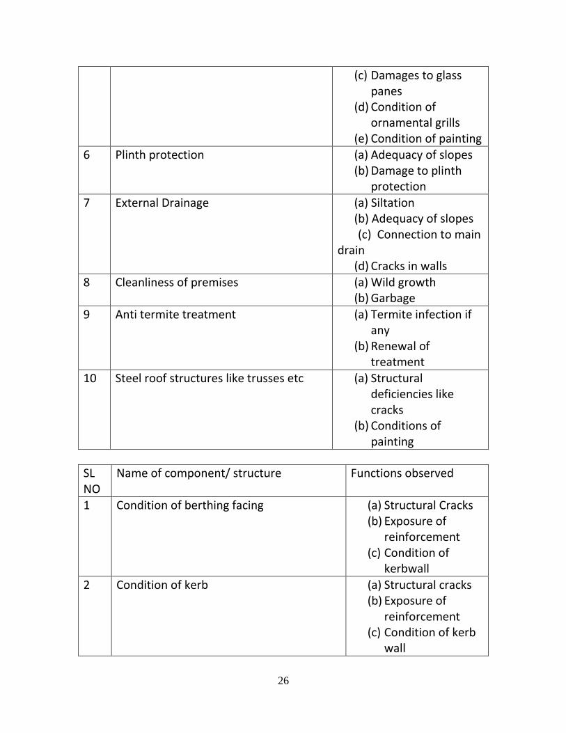
3 Major damages if any
-
4 Any observations -
Marine fixtures
Sl No
Name of component/ structure Parameters to be observed
1 Fenders (a) Surface cracks (b) Deep cracks (c) Edge cord (d) Cords of bolts and
frames (e) Frontal frames (f) Hooks & Chains
2 Chains (a) Corrosion and damages
(b) Cord of paintings (c) slackers
3 Ladders (a) Cord Of Bolts and Nuts
(b) Vertical rails (c) Cord of rings (d) Painting/
Galvanizing
4 Mooring fixtures (a) Rings (b) Eye hooks (c) Painting
Photos gallery
28
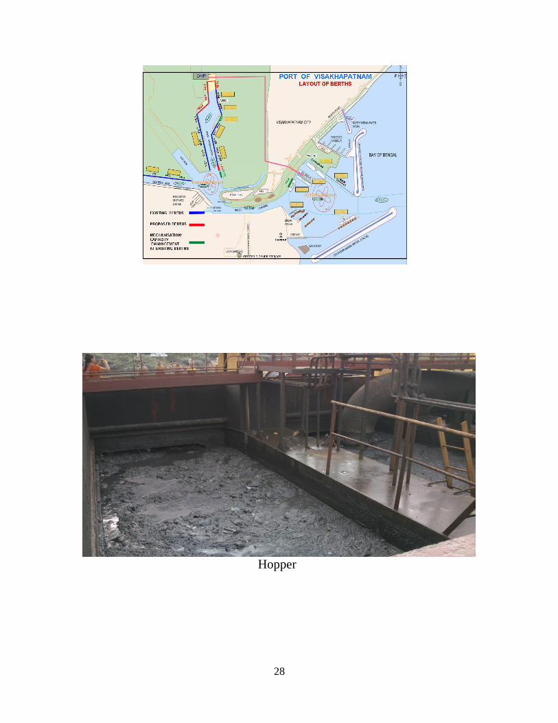
Hopper

29

30
31
ENVIRONMENT
Watering roads to control dust
pollution
High rise wall of 11.5 mts (for preventing pollution)
32
MAINTAINANCE
TYPES OF FENDERS:-
TYRE FENDER
M-TYPE FENDER
33
LADDER WITH TWO RUBBER STRIPS
ON EITHER SIDE
Drilling for installation of new fender