issn print: issn online: geomorphological mapping … mapping using remote sensing and gis a tool...
TRANSCRIPT
~ 616 ~
ISSN Print: 2394-7500 ISSN Online: 2394-5869 Impact Factor: 5.2 IJAR 2015; 1(9): 616-619 www.allresearchjournal.com Received: 02-06-2015 Accepted: 04-07-2015 Shankaraiah Katla Dept. of Applied Geochemistry, Osmania University Hyderabad, T.S., India. Praveen Raj Saxena Dept. of Applied Geochemistry, Osmania University Hyderabad, T.S., India. Correspondence: Shankaraiah Katla Dept. of Applied Geochemistry, Osmania University Hyderabad, T.S., India.
Geomorphological mapping using Remote Sensing and
GIS a tool for land use planning in and around Suryapet City, T.S., India
Shankaraiah Katla, Praveen Raj Saxena Abstract Landforms on the earth surface are expensive to map or monitor. Remote Sensing observations from space platforms provide a synoptic view of terrain on images. Satellite multispectral data have an advantage in that the image data in various bands can be subjected to digital enhancement techniques for highlighting contrasts in objects for improving image interpretability. Landforms are interpreted on the basis of interpretation element keys namely such as- tone, texture, size, shape, color etc. and extract the specific information from the false color composites LISS-III sensor images. Geomorphological units are classified on the basis differential erosion processes. The data carried out in the year of 2012, in the study area, mainly Pedi plains of Archaean Gneiss and pediments of granites are predominant landforms. Apart from these above geomorphic units, Pediment Incelberg Complex, Inselberg, Bazada, Dolerite Dikes, structural hills and residual hills are mapped using IRS-ID LISS-III satellite imagery using visual interpretation technique along with field check. Remote Sensing and GIS offers detecting, analyzing and time cost effective way to fulfill these goals. Keywords: Geomorphology mapping, GIS, IRS-1D LISS-III, Remote Sensing
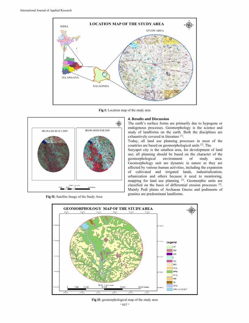
1. Introduction Now-a-days, Land use planning is important task for local and government authority to provide suitable land for human activities in the study area so it is realized that land use planning need to be developed in an integrated and comprehensive manner based on geomorphic study. In this study, Remote Sensing and GIS, tools and techniques are used to identify landform, geomorphic units and area mapping because geomorphology is the base of land use planning. 2. Study Area The area under study lies between 16°56’-17°18’ degrees latitude and 79°25’-79°48’ degrees longitude and falls in SOI toposheet number 56O/12 and partially in its adjacent toposheet, covering total area of approximately- 1253 sq. km and height from the mean sea level is 571 m. It forms a part of Nalgonda District which is bounded on the north by Ranga Reddy & Warangal districts and south by Krishna & Guntur districts respectively, on the east by Khammam and on the west by Mahabubnagar district. 3. Data Used and Methodology NRSC (National Remote Sensing Centre, Hyderabad) collected the IRS-1D LISS-III data (24th January, 2009) in digital form and topographic maps 56O/12 and partially in its adjacent toposheet at scale 1:50,000 published by Survey of India (SOI) have been utilized. Digital data registered with SOI toposheet and identified different hydro geomorphological units, mapping with image interpretation techniques, digital image processing, exiting geology and geomorphology map using Erdas 8.6 and ArcGIS 9.0 and verified with GCPs collection.
International Journal of Applied Research 2015; 1(9): 616-619
~ 617 ~
International Journal of Applied Research
Fig I: Location map of the study area
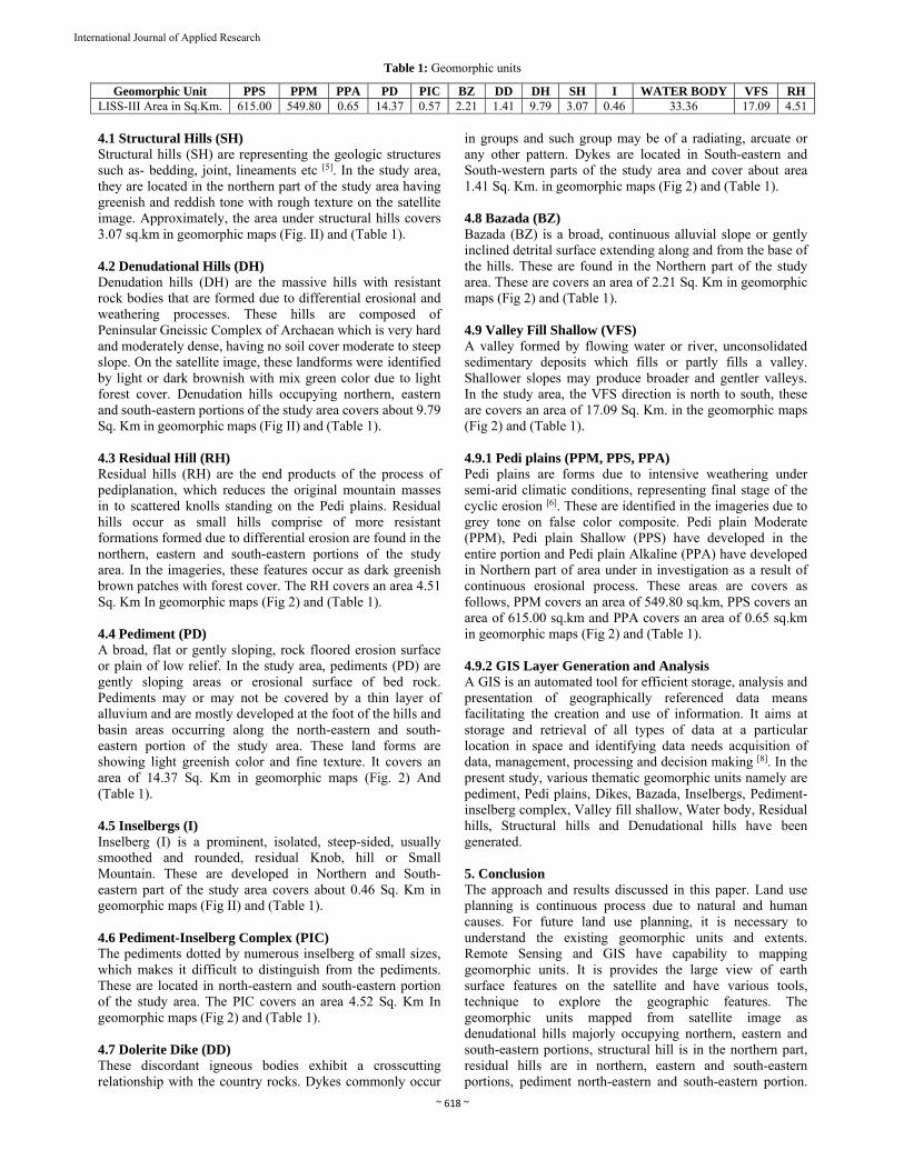
Fig II: Satellite Image of the Study Area
4. Results and Discussion The earth’s surface forms are primarily due to hypogene or endogenous processes. Geomorphology is the science and study of landforms on the earth. Both the disciplines are exhaustively covered in literature [1]. Today, all land use planning processes in most of the countries are based on geomorphological units [2]. The Suryapet city is the smallest area, for development of land use; all planning should be based on the character of the geomorphological environment of study area. Geomorphology unit are dynamic in nature as they are affected by various human activities, including the expansion of cultivated and irrigated lands, industrialization, urbanization and others because it need to monitoring, mapping for land use planning [3]. Geomorphic units are classified on the basis of differential erosion processes [4]. Mainly Pedi plains of Archaean Gneiss and pediments of granites are predominant landforms.
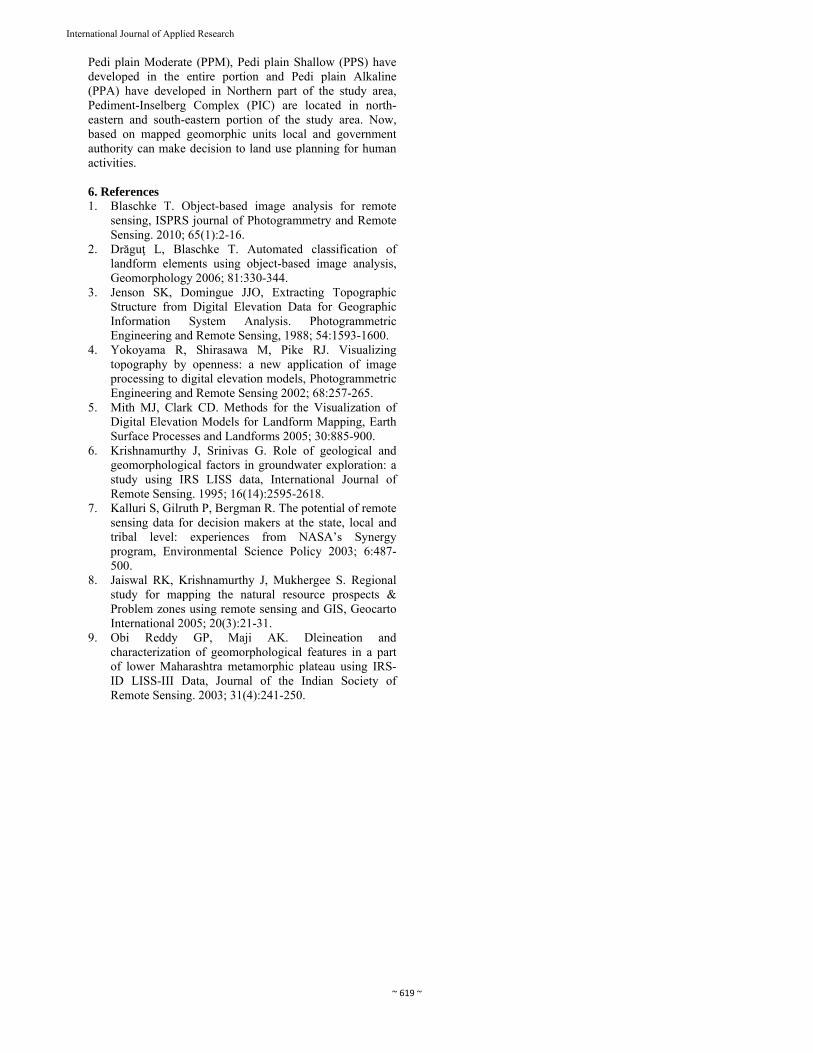
Fig II: geomorphological map of the study area
~ 618 ~
International Journal of Applied Research
Table 1: Geomorphic units
Geomorphic Unit PPS PPM PPA PD PIC BZ DD DH SH I WATER BODY VFS RH LISS-III Area in Sq.Km. 615.00 549.80 0.65 14.37 0.57 2.21 1.41 9.79 3.07 0.46 33.36 17.09 4.51
4.1 Structural Hills (SH) Structural hills (SH) are representing the geologic structures such as- bedding, joint, lineaments etc [5]. In the study area, they are located in the northern part of the study area having greenish and reddish tone with rough texture on the satellite image. Approximately, the area under structural hills covers 3.07 sq.km in geomorphic maps (Fig. II) and (Table 1). 4.2 Denudational Hills (DH) Denudation hills (DH) are the massive hills with resistant rock bodies that are formed due to differential erosional and weathering processes. These hills are composed of Peninsular Gneissic Complex of Archaean which is very hard and moderately dense, having no soil cover moderate to steep
slope. On the satellite image, these landforms were identified by light or dark brownish with mix green color due to light forest cover. Denudation hills occupying northern, eastern and south-eastern portions of the study area covers about 9.79 Sq. Km in geomorphic maps (Fig II) and (Table 1). 4.3 Residual Hill (RH) Residual hills (RH) are the end products of the process of pediplanation, which reduces the original mountain masses in to scattered knolls standing on the Pedi plains. Residual hills occur as small hills comprise of more resistant formations formed due to differential erosion are found in the northern, eastern and south-eastern portions of the study area. In the imageries, these features occur as dark greenish brown patches with forest cover. The RH covers an area 4.51 Sq. Km In geomorphic maps (Fig 2) and (Table 1). 4.4 Pediment (PD) A broad, flat or gently sloping, rock floored erosion surface or plain of low relief. In the study area, pediments (PD) are gently sloping areas or erosional surface of bed rock. Pediments may or may not be covered by a thin layer of alluvium and are mostly developed at the foot of the hills and basin areas occurring along the north-eastern and south-eastern portion of the study area. These land forms are showing light greenish color and fine texture. It covers an area of 14.37 Sq. Km in geomorphic maps (Fig. 2) And (Table 1). 4.5 Inselbergs (I) Inselberg (I) is a prominent, isolated, steep-sided, usually smoothed and rounded, residual Knob, hill or Small Mountain. These are developed in Northern and South-eastern part of the study area covers about 0.46 Sq. Km in geomorphic maps (Fig II) and (Table 1). 4.6 Pediment-Inselberg Complex (PIC) The pediments dotted by numerous inselberg of small sizes, which makes it difficult to distinguish from the pediments. These are located in north-eastern and south-eastern portion of the study area. The PIC covers an area 4.52 Sq. Km In geomorphic maps (Fig 2) and (Table 1). 4.7 Dolerite Dike (DD) These discordant igneous bodies exhibit a crosscutting relationship with the country rocks. Dykes commonly occur
in groups and such group may be of a radiating, arcuate or any other pattern. Dykes are located in South-eastern and South-western parts of the study area and cover about area 1.41 Sq. Km. in geomorphic maps (Fig 2) and (Table 1). 4.8 Bazada (BZ) Bazada (BZ) is a broad, continuous alluvial slope or gently inclined detrital surface extending along and from the base of the hills. These are found in the Northern part of the study area. These are covers an area of 2.21 Sq. Km in geomorphic maps (Fig 2) and (Table 1). 4.9 Valley Fill Shallow (VFS) A valley formed by flowing water or river, unconsolidated sedimentary deposits which fills or partly fills a valley. Shallower slopes may produce broader and gentler valleys. In the study area, the VFS direction is north to south, these are covers an area of 17.09 Sq. Km. in the geomorphic maps (Fig 2) and (Table 1). 4.9.1 Pedi plains (PPM, PPS, PPA) Pedi plains are forms due to intensive weathering under semi-arid climatic conditions, representing final stage of the cyclic erosion [6]. These are identified in the imageries due to grey tone on false color composite. Pedi plain Moderate (PPM), Pedi plain Shallow (PPS) have developed in the entire portion and Pedi plain Alkaline (PPA) have developed in Northern part of area under in investigation as a result of continuous erosional process. These areas are covers as follows, PPM covers an area of 549.80 sq.km, PPS covers an area of 615.00 sq.km and PPA covers an area of 0.65 sq.km in geomorphic maps (Fig 2) and (Table 1). 4.9.2 GIS Layer Generation and Analysis A GIS is an automated tool for efficient storage, analysis and presentation of geographically referenced data means facilitating the creation and use of information. It aims at storage and retrieval of all types of data at a particular location in space and identifying data needs acquisition of data, management, processing and decision making [8]. In the present study, various thematic geomorphic units namely are pediment, Pedi plains, Dikes, Bazada, Inselbergs, Pediment-inselberg complex, Valley fill shallow, Water body, Residual hills, Structural hills and Denudational hills have been generated. 5. Conclusion The approach and results discussed in this paper. Land use planning is continuous process due to natural and human causes. For future land use planning, it is necessary to understand the existing geomorphic units and extents. Remote Sensing and GIS have capability to mapping geomorphic units. It is provides the large view of earth surface features on the satellite and have various tools, technique to explore the geographic features. The geomorphic units mapped from satellite image as denudational hills majorly occupying northern, eastern and south-eastern portions, structural hill is in the northern part, residual hills are in northern, eastern and south-eastern portions, pediment north-eastern and south-eastern portion.
~ 619 ~
International Journal of Applied Research
Pedi plain Moderate (PPM), Pedi plain Shallow (PPS) have developed in the entire portion and Pedi plain Alkaline (PPA) have developed in Northern part of the study area, Pediment-Inselberg Complex (PIC) are located in north-eastern and south-eastern portion of the study area. Now, based on mapped geomorphic units local and government authority can make decision to land use planning for human activities. 6. References 1. Blaschke T. Object-based image analysis for remote
sensing, ISPRS journal of Photogrammetry and Remote Sensing. 2010; 65(1):2-16.
2. Drăguţ L, Blaschke T. Automated classification of landform elements using object-based image analysis, Geomorphology 2006; 81:330-344.
3. Jenson SK, Domingue JJO, Extracting Topographic Structure from Digital Elevation Data for Geographic Information System Analysis. Photogrammetric Engineering and Remote Sensing, 1988; 54:1593-1600.
4. Yokoyama R, Shirasawa M, Pike RJ. Visualizing topography by openness: a new application of image processing to digital elevation models, Photogrammetric Engineering and Remote Sensing 2002; 68:257-265.
5. Mith MJ, Clark CD. Methods for the Visualization of Digital Elevation Models for Landform Mapping, Earth Surface Processes and Landforms 2005; 30:885-900.
6. Krishnamurthy J, Srinivas G. Role of geological and geomorphological factors in groundwater exploration: a study using IRS LISS data, International Journal of Remote Sensing. 1995; 16(14):2595-2618.
7. Kalluri S, Gilruth P, Bergman R. The potential of remote sensing data for decision makers at the state, local and tribal level: experiences from NASA’s Synergy program, Environmental Science Policy 2003; 6:487-500.
8. Jaiswal RK, Krishnamurthy J, Mukhergee S. Regional study for mapping the natural resource prospects & Problem zones using remote sensing and GIS, Geocarto International 2005; 20(3):21-31.
9. Obi Reddy GP, Maji AK. Dleineation and characterization of geomorphological features in a part of lower Maharashtra metamorphic plateau using IRS-ID LISS-III Data, Journal of the Indian Society of Remote Sensing. 2003; 31(4):241-250.