island management - the department of state … · appendix i – demonstration case island...
TRANSCRIPT

Appendix I – Demonstration Case Island Management I-1
Island Management Demonstration case jointly prepared with the GBRMPA
Relevance to Queensland Government Program
Program Component MNES and OUV Type of activity
Overall effectiveness
Effectiveness of island management to avoid, mitigate and protect MNES
Nature Conservation Act 1992
Great Barrier Reef Marine Park Act
GBR Coast Marine Park
GBR field management program
GBR World Heritage Area
GBR Marine Park
Threatened species
Listed migratory species
Recreational and commercial use
Tourist development
Protected area management
Residential development
Effective
In general, the condition of the islands managed by the GBRMPA and QPWS was assessed as stable with processes in place to manage impacts.

Appendix I – Demonstration Case Island Management I-2
1.1 INTRODUCTION AND PURPOSE This demonstration case on island management shows how the Queensland and Australian Governments identify and protect the islands within the Great Barrier Reef World Heritage Area (GBRWHA). Islands contribute to all four of the natural criteria for which the World Heritage Area was listed in 1981: exceptional natural beauty, significant geomorphic features, significant ongoing ecological and biological processes, and significant natural habitats for the conservation of biological diversity. These features in combination with the complexity of their jurisdictional and management arrangements make island management an excellent demonstration case. Islands are a unique component of the GBRWHA and therefore critical to its integrity. Interconnected reef and island ecosystems support some of the richest biodiversity on the planet.
There are about 1050 islands in the GBRWHA with a range of tenures and management arrangements in place. Three broad types of islands are recognised: mangrove islands, continental islands, and reef islands or coral cays, which are described in detail in Appendix 1.
Approximately 70 are Commonwealth Islands (Figure 1.1-1) within the Commonwealth Islands Zone of the Great Barrier Reef (GBR) Marine Park, of which 21 are managed by the Great Barrier Reef Marine Park Authority (GBRMPA). The Department of Defence owns all the remaining Commonwealth Islands in the GBRWHA, except for Little Fitzroy Island which is owned by the Department of Finance and Deregulation.
The State of Queensland has jurisdiction over approximately 980 islands. About 400 of these islands are included in 64 protected areas (e.g. national parks), with the intertidal areas of at least 50 islands incorporated within 14 declared Fish Habitat Areas. Island National Parks and declared Fish Habitat Areas are managed by the Queensland Government Parks and Wildlife Service (QPWS - a division of the Department of National Parks Recreation Sport and Racing). The tenure on the remaining islands includes leasehold, freehold, unallocated State land, and Aboriginal land.
This demonstration case, prepared jointly by QPWS and the GBRMPA, addresses island management for those islands forming part of Queensland’s protected area estate and the 21 Commonwealth Islands managed by the GBRMPA, which total approximately 45 per cent of all the islands in the GBRWHA.
Given the variation in pressures and impacts experienced across this vast number of islands, the analysis provides a broad evaluation.

Appendix I – Demonstration Case Island Management I-3
Figure 1.1-1 Commonwealth Islands in the GBR Marine Park.
(The GBRMPA manages Kent Island, the Pipon Island, Unamed Island (Pipon Island Group), Russell Island, North Reef Island, Low Isles, Pine Islet, Lady Elliot Island, Albany Rock, Coppersmith Island, Hannah Island, Bailey Islet, Clerke Island, Coquet Island, Eshelby Island, Hannibal Island, High Peak Islet, Rocky Island and South Brook Island, together with parts of Dent and Penrith Islands)

Appendix I – Demonstration Case Island Management I-4
1.1.1 STRUCTURE AND GEOGRAPHICAL SCOPE
The comprehensive identification of the ecological, heritage and community values, impacts and management arrangements of approximately 1 050 islands in the GBRWHA is beyond the scope of this demonstration case. Instead, a broad range of information on islands that are managed by GBRMPA and QPWS has been presented throughout the demonstration case. To complement this general overview, Appendices 2-9 provide eight specific examples of a cross-section of representative islands which highlight important issues relating to the ongoing management and protection of islands in the GBRWHA.
Queensland Government managed:
Raine Island
Hinchinbrook Island
Magnetic Island
Curtis Island
Great Keppel Island
GBRMPA managed:
Low Isles
Lady Elliot Island
Jointly managed:
Dent Island North – GBRMPA
Dent Island South – Queensland Government
This demonstration case is structured into sections describing the ecology, heritage and community values of islands, the activities occurring on islands and the impacts arising from these activities. The effectiveness of management to avoid, mitigate or offset impacts is described and evaluated, including measures to enhance matters of national environmental significance (MNES).
Appendix I – Demonstration Case Island Management I-5
1.2 HOW THE PROGRAM IDENTIFIES IMPORTANT ISLAND VALUES THAT UNDERPIN MNES, INCLUDING OUV PURPOSE
1.2.1 SIGNIFICANCE OF ISLANDS AS A MNES
Islands are elements underpinning the following MNES as defined in the Environment Protection and Biodiversity Conservation Act 1999 (EPBC Act):
World Heritage properties
National heritage places
listed threatened species and ecological communities
migratory species protected under international agreements
Australian Government marine areas
the GBR Marine Park
Islands are an important part of the GBR ecosystem and provide a range of ecosystem services (Table 1.2-1). Playing important roles in the life cycle of many species of flora and fauna, islands provide shelter, living space, feeding and breeding grounds and nesting habitats for many marine and terrestrial species, including some of which are endemic and listed under Australian or Queensland Government legislation as near threatened, vulnerable, or endangered.
Islands often function as refugia for plants and animals, protecting these from prevalent and increasing impacts found on the mainland. They are also hotspots of evolution and in some cases have developed divergent or endemic species of flora and fauna.

Appendix I – Demonstration Case Island Management I-6
Table 1.2-1 Summary table of ecosystem goods and services provided by islands
Ecosystem goods and services category Services provided by the habitat
Supporting services (e.g. primary production, provision of habitat, nutrient cycling, soil formation and retention, production of atmospheric oxygen, water cycling)
Breeding ground and/or shelter to several species of fauna like sea turtles, seabirds and shore birds. These species also provide nutrient input that supports island vegetation and stabilisation.
Sediment storage and transport. Breakdown of organic materials and pollutants. Water filtration and purification. Nutrient mineralisation and recycling. Nursery for juvenile fishes.
Regulating services (e.g. invasion resistance, herbivory, pollination, climate regulation, disease regulation, natural hazard protection)
Wave dissipation and associated buffering against extreme events.
Dynamic response to sea level rise (within limits). Water storage in dunes aquifers and groundwater discharge
trough beaches. Create and affect currents and tidal movements.
Provisioning services (e.g. food, fibre, genetic resources, biochemicals, fresh water)
Maintenance of biodiversity and genetic resources. Mangrove islands as renewable source of wood. Not a common
practice in GBR. Various foods traditionally hunted and gathered from islands,
for example birds and eggs.
Cultural and economic services (e.g. spiritual values, knowledge system, education and inspiration, recreation and aesthetic values, sense of place)
Important cultural sites and spiritual values exist on many islands and reefs in the GBR region: o sacred sites o ceremony sites o burial grounds
Scenic vistas and recreational opportunities. Educational value. Historical value. Economic value for tourism industry. Popular sites of resorts (for example Whitsunday Islands, Dunk
Island, Green Island, Bedarra Island, Hinchinbrook Island) and residential communities (for example Magnetic Island, Curtis Island).
Scientific research. Many Commonwealth Islands have heritage values due to the
existence of historic light stations, associated shipping and navigation history.

Appendix I – Demonstration Case Island Management I-7
1.2.2 HOW THE PROGRAM IDENTIFIES ISLANDS AS IMPORTANT VALUES THAT UNDERPIN MNES, INCLUDING OUV
The islands of the GBRWHA are global strongholds for seabirds, turtles and other wildlife as well as being important recreational areas and valuable ecotourism destinations. Managing such a large and diverse suite of islands with a wide range of values and threats requires a system for prioritising conservation management actions. For islands that form part of the protected area estate, GIS tools, remotely sensed data and ground surveys are used to map a variety of features such as regional ecosystems, current and past fire regimes, invasive species distribution, and threatened species habitat.
1.2.2.1 SIGNIFICANT ISLAND HABITAT AND FLORA The interaction between an island’s geomorphology and geography greatly influences its character, and associated ecological values. Three broad types of islands are recognised: mangrove islands, continental islands, and reef islands or coral cays (Figure 1.2-1), which are described in detail in Appendix 1.

Appendix I – Demonstration Case Island Management I-8
Figure 1.2-1 Generalised island geomorphology

Appendix I – Demonstration Case Island Management I-9
Approximately 2000 species of plants are found on the continental islands of the GBRWHA, which represents about one quarter of Queensland's vascular flora. More than 70 of these species are listed as near threatened, vulnerable or endangered in Queensland, and eight of which are considered endemic to continental islands (Table 1.2-2). Continental islands have vegetation types ranging from rainforest to dry-open woodlands and grasslands. Of all plant species found on the continental islands, rainforest species account for 48 per cent, open forest species 46 per cent and littoral plant species six per cent.
Species richness on continental islands is largely dependent on island size, its historical use and habitat diversity. There exists a linear relationship between species richness and island size, with a noticeable increase in species on islands greater than 5000 hectares in size. Hinchinbrook and Curtis Islands are the most diverse continental islands in the GBRWHA, each one with about 600 species of terrestrial flora. Floral species richness is also related to the distance of an island from the mainland, with a greater distance corresponding with a lower richness. Significant endemic flora of the islands is described in Table 1.2-2.
Table 1.2-2 Plant species endemic to GBR islands
Species Location Details
Berrya rotundifolia Calder (Cumberland Group) and Middle Percy Islands
Vine scrub tree – near threatened status
Buchanania mangoides Central GBR islands Rainforest tree – near threatened status
Kunzea graniticola Hinchinbrook Island Scrubland shrub
Gossia sp. Lizard island Open-scrub shrub species
Phychotria lorentzii Lizard Island Vine scrubland, scrambling shrub – near threatened status
Tetramolopium sp. Mt Bowen and Hinchinbrook Island Scrubby herb – near threatened status
Allocasuarina (Allocasuarina sp.) Shaw Island (Whitsunday Group) Open forest tree
Albizia (Albizia sp.) South Percy Island Beach scrub small tree
The location and size of vegetated coral cays determine their plant species richness. The northern cays have higher species richness (around 200 species) whereas southern cays have around 80 species. The difference in species diversity is related to the proximity of the cay to the mainland as well as longitude and latitude. Coral cays in the northern GBR are closer to the mainland and experience more tropical conditions and are found to have more complex low wooded habitats with mangroves and wood beach scrub, as well as more littoral rainforest species.
The islands of the GBRWHA hold the largest area of Pisonia grandis closed forest in Australia (predominantly on the Capricorn and Bunker Islands of the southern GBR), covering an area of approximately 160 hectares. The Pisonia forests are recognised as important nesting habitat for seabirds. These forests are confined to these islands and are established through seed dispersal by seabirds. The Capricorn Bunker group is considered one of the richest areas for breeding seabirds on the GBR due to the presence of these established forests. North West Island, in the Capricorn Bunker Group, supports 60 per cent of the Pisonia in the GBRWHA, and over 50 per cent of the biomass of breeding seabirds on the GBR.
1.2.2.2 Significant island fauna The diversity of terrestrial fauna found on the islands of the GBR is similar to that of the adjacent mainland, although with fewer species. Individual differences between the fauna of the islands are due mainly to differences in shore profile, wave action and latitude. Significant endemic fauna of the islands is described in Table 1.2-3.

Appendix I – Demonstration Case Island Management I-10
Table 1.2-3 Significant endemic terrestrial fauna of GBR Islands
Species Location EPBC Act Status
Notes
Bramble Cay melomys (Melomys rubicola)
Bramble Cay Endangered Quite likely extinct due to changes in vegetation. Endemic to the cay
Capricorn white-eye (Zosterops lateralis chlorocephala)
Capricorn Bunker Group Endemic to the island group
Dawson yellow chat (Ephianura crocea macgregori)
Curtis Island Critically endangered
In Action Plan for Australian Birds
White-rumped swiftlet (Collocalia spodiopygiu)
Dunk Island Rare, nests in caves
Common death adder (Acanthophis antarcticus)
Gloucester Island Rare. Death adders on adjacent mainland are northern species
Proserpine rock-wallaby (Petrogale persephone)
Gloucester Island, Hayman Island (Whitsunday Group)
Endangered On Mainland and the two islands
Coastal sheathtail-bat (Taphozous australis)
Magnetic Island and islands in the Whitsunday Group.
Vulnerable (NC Act). Inhabits a narrow coastal zone.
Northern quoll (Dasyurus hallucatus)
Magnetic Island Endangered Rediscovered on Magnetic Island
Rusty goanna (Varanus semiremex) Magnetic Island Rare.
Sadlers dwarf skink (Menetia sadlieri) Magnetic Island Endemic to the island
Striped-tailed delma (Delma labialia) Magnetic Island Vulnerable In Action Plan for Australian Reptiles
A skipper butterfly (Hersperilla malindeva dogoomba)
Magnetic Island, Scawfell Island (Cumberland Group)
Recently described, endemic to GBR islands
Koala (Phascolarctus cinereus) Magnetic Island, St Bees Island (Cumberland Group) and Newry Islands
Vulnerable Introduced from the mainland. Stable populations
Whitsunday azure butterfly (Ogyris zosine zolivia)
Whitsunday Group Endemic to Whitsunday Group. Habitat dependant
Land snail (Varohadra macneilli) Double Cone Island (Whitsunday Group)
Most likely endemic to islands in the Whitsunday Group.
Rainbow skink (Carlia pectoralis inconnexa)
Whitsunday Group Endemic to islands in the Whitsunday Group.
Leaf tail gecko (Phyllurus spp.) Whitsunday Island Endemic
More than 25 per cent of the tropical seabirds of Australia nest on the islands of the GBR, made up of 24 different species and 1.7 million individuals. The distribution of seabirds within the GBRWHA corresponds with the distribution of islands, with the northern and southern areas of the GBR representing the most important breeding sites with larger colonies of seabirds due to the higher number of suitable island habitats. The most abundant species found in the GBRWHA are the black noddy and the shearwater. The far northern, northern and far southern regions have the largest colonies.

Appendix I – Demonstration Case Island Management I-11
Raine Island in the north of the Marine Park is one of the most important seabird breeding sites in Australia and the most significant seabird rookery in the GBRWHA. Of the 24 species of seabird that breed in Queensland, 14 occur on Raine Island. Michaelmas Cay, also in the north of the GBR Marine Park, is recognised as the second most important bird nesting site in the northern part of the GBRWHA.
Seabirds have a major role in transferring nutrients from offshore and pelagic areas to islands and reefs. For example, black noddies deposit an estimated four tonnes of guano on Heron Island per annum. Reef islands are largely dependent on the surrounding regions of the sea for influx of nutrients, mainly deposited by roosting and nesting seabirds. Such nutrients are crucial for the plants on coral cays, which often maintain a stable vegetation assemblage that in turn provides suitable habitat and shelter for many birds and other species.
Many islands in the GBRWHA also provide important roosting and feeding habitat for migratory shorebird species that are of State, national and international significance. Migratory species spend the non-breeding season (September to April) in the area and migrate annually to their breeding grounds in the Northern Hemisphere during the austral winter.
There are 38 islands on the GBR that are important sites for turtle nesting, especially Raine Island, Milman Island, Wild Duck Island, Peak Island and the cays of the Capricorn Bunker Group. These islands are, on a global scale, important for the survival of four species of marine turtles: loggerhead, green, hawksbill and flatback, the latter endemic to Australia. The world’s largest population of nesting green sea turtles (Chelonia mydas) occurs on Raine Island.
One species of crocodile, the estuarine crocodile (Crocodylus porosus) is found on and around continental, coral cays and low wooded islands. It occurs on approximately 25 per cent of the islands on the Far Northern Section but in general the main habitat of this crocodile is outside of the GBR on mainland Australia. Crocodiles are a threatened species and are afforded protection under the Queensland Government’s Nature Conservation Act 1992.
At least nine species of snake and 31 lizard species are found on the islands of the GBRWHA. These reptiles are found on continental islands, occupying habitats similar to those on the mainland. A number of lizards are endemic to islands (for example the Magnetic Island skink), particularly those of the northern and central parts of the GBR. The amount of species richness in terrestrial reptiles decreases with both increasing latitude and increasing distance from the mainland shore.
Values underpinning MNES (ecological, heritage and community benefits) are described in more detail for eight representative islands within the GBRWHA in Appendices 2-9.

Appendix I – Demonstration Case Island Management I-12
1.3 PRESSURES AND POTENTIAL IMPACTS This section broadly describes impacts for a suite of anthropogenic and natural events which affect the MNES and OUV of islands in the GBRWHA. It is relevant to note that:
Islands vary in their sensitivity and exposure to pressures, partly as a consequence of their geomorphological and geographical characteristics (Appendix 1 Geology and geography of islands).
Island geomorphology influences island stability and habitat complexity with islands in northern latitudes experiencing more tropical conditions such as higher rainfall and more cyclones.
Island size influences species richness and diversity, which in turn influences its capacity to recover from impacts like cyclones, extreme weather and invasive species.
Proximity to the mainland influences species richness and diversity, and exposure to a range of coastal impacts (including pests and weeds).
Multiple activities may cause the same impacts so it is important to consider not only the potential impacts of individual activities, but also the potential cumulative impact of activities that are likely to affect islands, over both the short and long terms.
The degree of exposure to a range of impacts may differ between islands.
1.3.1 ACTIVITIES AND EVENTS
1.3.1.1 TOURISM AND RECREATION Islands in the GBRWHA are important for tourism and recreation – 27 islands have resorts and/or residential communities. An estimated 40 per cent of the 1.8 million tourists to the GBR in 2011 included an island destination in their visit. Green Island is one of the most popular coral cay destinations on the GBR, with around 350 000 visitors per year (up to 2240 daily). In addition, Michaelmas Cay, Upolu Cay, Low Isles, and Beaver Cay are the main coral cays that are visited on day tours on a regular basis by reef tour operators. At the end of June 2013, approximately 110 commercial tour operators held permits, issued under the Queensland Government’s Nature Conservation Act 1992 to access island National Parks within the GBRWHA. Tourism and recreation can potentially impact the MNES on islands by:
Disturbance to wildlife.
Disturbance from artificial lighting – turtle hatchlings can be disoriented by artificial light so that they head landward instead of seaward.
Waste discharge (including litter, bush toileting and sewage).
Transfer of pests (invasive species and pathogens) from the mainland and between islands.
Trampling and vehicular traffic can lead to the localised permanent damage to vegetation cover and consequent erosion of soil. This can reduce burrowing substrate for birds and, during heavy rainfall, lead to the flooding and deposition of sediment in downslope breeding areas, changing vegetation and soil structure and possible disruption to breeding activities. Soil disturbance also leads to increased weed colonisation, which can in turn lead to increased fire risk.
Risk of wildfire from campfires.
Increased development pressure for facilities, resorts, vessel landing areas (jetties, boat ramps).
Domestic animals.
Development of informal tracks and camping sites.

Appendix I – Demonstration Case Island Management I-13
1.3.1.2 DEFENCE ACTIVITIES Approximately 38 islands are located in Defence exercise areas. Islands used by the Department of Defence are Townshend, Raynham and Triangular Islands (in the Shoalwater Bay Training Area, Central Queensland) and Rattlesnake Island in Halifax Bay (North Queensland). Most defence activities occur on the three islands in the Shoalwater Bay Training Area. Live firing with military aircraft occurs on regular occasions at Rattlesnake Island in Halifax Bay.
Potential impacts on island MNES associated with defence activities include boat strike to turtles, and the disturbance of wildlife from the presence of large numbers of personnel, use of explosives, lighting and noise.
1.3.1.3 TRADITIONAL USE OF MARINE RESOURCES Traditional Owners have a close and on-going association with islands in the GBRWHA. Islands have important natural, cultural and spiritual values (e.g. sacred sites, ceremony sites, burial grounds and hunting grounds).
Traditional hunting and associated camping occurs on and around some islands and cays, and islands have been an important seasonal source of food historically (e.g. birds and eggs). Impacts are considered minimal and limited to a few islands. Traditional Use of Marine Resource Agreements (TUMRAs) or Indigenous Land Use Agreements (ILUAs) cover some islands including Raine Island and the Keppel Islands.
1.3.1.4 HISTORICAL HERITAGE – NAVIGATIONAL AIDS Twenty one islands have historic light stations associated with shipping and navigational history. Construction of stations resulted in small scale clearing or modifying coastal habitats, the introduction of exotic species and pests to the islands, and terrestrial point source discharge of sewage when the light stations were occupied. The impacts of these are considered minimal and limited to a few islands. The upkeep of the station structures is a more significant issue, as buildings contain asbestos, and as heritage buildings fall into disrepair asbestos has become a source of marine debris at some locations (e.g. Dent Is. and Lady Elliot Is.). Routine servicing of the lighthouses and navigational aids, still in use today has the potential to introduce pest species and disturb wildlife (particularly seabirds).
1.3.1.5 SCIENTIFIC RESEARCH Research occurs on a wide range of islands and there are four research stations on Heron Island, One Tree Island, Orpheus Island, Lizard Island. Between 1926 and 1929, Low Isles was the site of the first detailed scientific study of a coral reef anywhere in the world. While the benefits to the management of the GBRWHA are significant, as an activity it is acknowledged that scientific research can contribute to the collection and disturbance of wildlife. The impacts of these are considered minimal and temporary and are outweighed by the long-term benefits that research provides.
1.3.1.6 COASTAL DEVELOPMENT Islands have a natural process of erosion and accretion, which can be modified by the effects of coastal development, port developments, marinas and associated dredging. Impacts interfering with this natural process can include, transport or re-suspension of contaminants, fringing reef damage and alteration of sediment movement. Impacts from catchment run-off are more apparent around near-shore islands, which have greater exposure to flood plumes.
1.3.1.7 CYCLONE ACTIVITY AND EXTREME WEATHER Beaches and coral cays (formed by accumulation of sediments) are heavily impacted by intense storms. Some features may be built up more rapidly by the accumulation of rubble and sand. Other features may be eroded by increased exposure to large waves and storm surge. Such changes are having important long-term consequences for animals such as nesting turtles and seabirds. Storms strip islands of vegetation
Appendix I – Demonstration Case Island Management I-14
(reducing suitable habitat for birds and other animals) and provides increased opportunity for spread and establishment of new pest infestations. Infrastructure on islands (e.g. Dunk Island) has also been destroyed, especially in recent times during Cyclones Yasi (2011) and Hamish (2009). The expected increase in intensity and frequency of storms will likely have significant impacts on islands in future.
1.3.1.8 INTRODUCTION OF EXOTIC SPECIES AND DISEASE The geographic isolation of islands limits colonisation of new species, allowing established species to evolve with few strong competitors and predators. Island visitors can introduce a range of plants and animal pest species, which may become established. These can induce changes in island vegetation and species that inhabit them. The value of islands as refugia for flora and fauna has been diminished by numerous species introductions, including:
Creation of 72 coconut plantations at separate locations on 47 islands, ranging from the Whitsunday Group to Sir Charles Hardy Island prior to 1900.
Destruction of island vegetation due to the historical introduction of goats at many islands, including St Bees Island, North Keppel, Lady Elliot and Lady Musgrave Island. Cays/islands that supported goat populations were severely degraded by overgrazing.
Introduction of Lantana to several islands in the Whitsunday Group: Lindeman, Haslewood, Henning, South Molle Islands and on more remote far northern islands such as Forbes Island. Prickly pear has been found at Hinchinbrook, Masthead and North Keppel Islands.
Deliberate stocking of islands with grazing animals, and the presence of feral pigs, cats, wallabies, pea fowl, guinea fowl, dogs, rabbits, snakes, rats, mice and foxes.
Recent spread of the invasive cane toad.
Introduction of mainland species (koala/wallaby) to islands (e.g. Brampton Island, long Island, St Bees Island).
Colonisation by rats on seabird nesting islands (e.g. Barnards, Boydong).
An example of the impact of introduced species is the scale insect (Pulvinaria urbicola) outbreaks which in combination with the highly invasive, exotic African big-head ant (Pheidole megacephala) caused serious declines in Pisonia forest in the Capricornia Cays over an eight year period. These cays support 84 per cent of Australia’s Pisonia forest, which in turn provide shelter and breeding habitat for many birds in the GBRWHA. The scale insect, which naturally occurs on the cays and mainland has symbiotic relationships with ants, which defend the scale insects from predators in return for honeydew from Pisonia sap. From 1993 to 2000, an outbreak destroyed 90 per cent of the Pisonia forest at Tryon Island.
1.3.1.9 CLEARING OR MODIFYING ISLAND HABITAT Large and small scale clearing of some island habitats has occurred as a consequence of island development and historical grazing. Despite changes in many islands of the GBR being substantial, Table 1.3-1 notes that the impact of clearing or modifying island habitat overall has had a low effect, requiring limited additional intervention. One example of substantial changes is guano and phosphate rock which was mined at 10 islands in the GBR from 1860-1949; Upolu, Oyster, and Michaelmas Cays, and Raine, Holbourne, Tyrone, North West, North Fairfax, Lady Musgrave and Lady Elliot Islands. Tens of thousands of tonnes of phosphate were extracted and exported. Guano mining resulted in major changes to Lady Elliot Island’s vegetation and to Raine Island's geomorphology and hydrology, some of which are now becoming more apparent. Given that these two islands are the most significant seabird nesting habitat on the GBR, they also provided the best guano deposits.
Twenty seven islands in the GBR have resorts and residential development. Large scale and varied impacts of island resorts (e.g. wildlife disturbance, light and noise pollution, litter, debris, loss of habitat, invasive species, inappropriate fire regimes, and altered amenity) are related to the construction of buildings, roads, airstrips and marinas (e.g. Hamilton Island, Magnetic Island, Curtis Island, Dent Island, Lady Elliot Island).

Appendix I – Demonstration Case Island Management I-15
Resort/marina expansions/improvements are proposed for Great Keppel Island, Fitzroy, Bedarra and Dunk Islands. New resort and residential developments are proposed for Hummock Hill Island and Magnetic Island.
Large scale industrial developments, such as the Curtis Island liquid natural gas (LNG) plants have led to significant localised impacts on islands including large scale habitat clearing. For more information, refer to Appendix 7.
Defence training exercises may result in small scale clearing or modifying island habitats as a result of vessel and personnel landings. Changes have occurred in the topography, vegetation and sea-bird populations of Fairfax Island as a result of military bombing practice between 1943 and at least 1965.
1.3.1.10 COASTAL DEVELOPMENT AND ALTERED HYDROLOGICAL FLOWS Sandy beach ecosystems on some islands are exposed to a range of development pressures. Structures built on or near islands can change hydrological flows and impact long-term patterns of shoreline sediment dynamics. Mitigation measures to prevent erosion can transfer the impacts to another part of the island. Green Island is a good example; the sediment budget has been affected by the construction of groynes on the islands between 1939 and 1980, causing severe down-drift erosion. Several unsuccessful attempts to nourish the beach have been made. Now a retaining wall has been developed to retain the sand. Heron Island has similar issues. The construction of a containing wall as a corrective measures transferred the problem to another site.
1.3.1.11 DREDGING-DIRECT IMPACTS, AND DUMPING AND RESUSPENSION OF DREDGE MATERIAL
Port development, marinas and associated supporting infrastructure may affect the hydrodynamic processes on and around islands, through dredging, coastal modifications and the dumping of spoil. This activity is considered to be having direct and significant impacts on Curtis Island (e.g. changed light horizons, vegetation clearing and disturbance, dust, noise and vibration). The broadscale assessment in Table 1.3-1 indicates that these impacts have a low effect which suggests, significant impacts are more localised.
1.3.1.12 MARINE DEBRIS Most debris on islands comes from marine-based sources, such as recreational vessels and commercial shipping. This impact is increasing in response to an increase in the time ships are spending at anchor outside ports and increased access by recreational and tourist vessels. An increase in the amount of litter has been reported to be washing up on the shores of Hinchinbrook Is and common debris collected from islands in the Whitsunday Group includes plastic beverage bottles, bottle tops, cleaning bottles, lighters, light plastic products, fishing gear and shoes. Debris affects the aesthetic value of the island, and affects island flora and fauna (e.g. through entanglement and ingestion).
1.3.2 SUMMARY OF INDIVIDUAL IMPACTS OF MOST CONCERN
As described above, a range of human-related marine and land-based activities can impact the MNES of islands in the GBRWHA. This analysis highlights that the greatest impacts on islands are those which affect them directly. They include climate change and extreme weather and impacts of exotic pests, and to a lesser extent clearing or modifying island habitats and development on or adjacent to the island itself. Table 1.3-1 summarises the generalised linkages between activities and the main past and present impacts affecting the area. Grades were based on the grading statements provided, and were assessed based on the information provided in this section, information published in the Strategic assessment report, and expert opinion. The results presented are an assessment of past and present effects on values, with an indication of future trend.

Appendix I – Demonstration Case Island Management I-16
Table 1.3-1 Past and present impacts on islands managed by the GBRMPA and QPWS, mapped to activities
Impact Future trend of the impact
Grade for islands
Clim
ate
chan
ge
Tour
ism
Rec
reat
ion
Trad
ition
al u
se
Res
earc
h ac
tiviti
es
Def
ence
act
iviti
es
Ship
ping
Port
s
Urb
an d
evel
opm
ent
Indu
stria
l dev
elop
men
t
Cyclone activity 3 X
Exotic species, pests and diseases 3 X X X X X X
Urban and industrial discharge 2 X X X X X
Altered hydrological flows 2 X X X X
Chemical and oil spills – small and large 2 X X X X X X
Clearing or modifying island and/or coastal habitats 2 X X X X X X X
Coastal reclamation 2 X X X X
Dumping and re-suspension of dredge material 2 X X X X
Dredging - direct impacts 2 X X X X X
Noise pollution 2 X X X X X X
Disturbance of wildlife 2 X X X X X X X X X
Acid sulphate soils 1 X X X
Boat strike on wildlife 1 X X X X X X X X
Increased sea temperature 1 X
Light impacts (artificial) 1 X X X X X X
Marine debris 1 X X X X X X X X X
Rising sea level 1 X
Sediments from catchment run-off 1 X X X X
Wash from vessels 1 X X X X X
Grounding of large vessels 1 X X

Appendix I – Demonstration Case Island Management I-17
Impact Future trend of the impact
Grade for islands
Clim
ate
chan
ge
Tour
ism
Rec
reat
ion
Trad
ition
al u
se
Res
earc
h ac
tiviti
es
Def
ence
act
iviti
es
Ship
ping
Port
s
Urb
an d
evel
opm
ent
Indu
stria
l dev
elop
men
t
Ocean acidification 1 X
Atmospheric pollution 0 X X X X
Freshwater inflow 0 X X X
Nutrients from catchment run-off 0 X X
Pesticides from catchment run-off 0 X X Note: The gradings in this table are the result of expert opinion regarding all the islands assessed in this demonstration case

Appendix I – Demonstration Case Island Management I-18
1.4 MEASURES TO AVOID, MITIGATE AND OFFSET IMPACTS ON MNES, INCLUDING OUV, ON ISLANDS WITHIN THE GBRWHA
Different Islands come under different jurisdictions within the GBRWHA. Islands may have Australian, State or local government management and exist in a wide variety of tenure types such as protected areas, leasehold, freehold, unallocated State land and Australian Government Island. Management agencies with responsibilities for managing islands and/or impacts on island habitat and associated species within the GBRWHA and the statutory and non-statutory tools that influence the conservation management of islands are listed below and in Appendix 10.
1.4.1 LEGISLATION AND OTHER STATUTORY INSTRUMENTS
Particularly relevant Australian and State legislation include:
Environment Protection and Biodiversity Conservation Act 1999
Great Barrier Reef Marine Park Act 1975
Nature Conservation Act 1992 (Qld)
Marine Parks Act 2004 (Qld)
Australian Heritage Commission Act 1975
Navigation Act 2012
Queensland Heritage Act 1992
Land Act 1994 (Qld)
Cape York Peninsula Heritage Act 2007 (Qld)
Recreation Areas Management Act 2006 (Qld)
Vegetation Management Act 1999 (Qld)
Environmental Protection Act 1994 (Qld)
Coastal Protection and Management Act 1995 (Qld)
Land Protection (Pest and Stock Route Management) Act 2002 (Qld)
Fisheries Act 1994 (Qld)
Existing management actions or plans of relevance to islands are listed below and described further in this section. They include:
Great Barrier Reef Marine Park zoning plan 2003
Marine parks (Great Barrier Reef coast) zoning plan 2004
Declared Fish Habitat Area Network Strategy 2009-2014
Local Government planning schemes
Cairns Area, Hinchinbrook and Whitsundays Plans of Management
Traditional Use of Marine Resource Agreements
Indigenous Land Use Agreements (ILUAs)

Appendix I – Demonstration Case Island Management I-19
Indigenous Management Agreements (IMAs)
Management Plans and Management Statements for all island National Parks.
1.4.2 POLICIES, POSITION STATEMENTS, GUIDELINES AND STRATEGIES
There are a number of non-statutory tools used for conservation management of islands in the GBRWHA that provide measures for avoiding, and mitigating impacts on MNES, including OUV. These include:
policies – that give effect to managing agency responsibilities, functions and powers
position statements – that outline the GBRMPA’s position on issues where the GBRMPA Board has a strong interest, but does not have legislative powers
guidelines – that generally support managing agencies’ policies or position statements and outlines process on certain issues.
Non-statutory tools of relevance to the management of impacts on islands are listed below:
Policy on moorings in the Great Barrier Reef Marine Park
Policy on managing scientific research in the Great Barrier Reef Marine Park
Policy on managing activities that include the direct take of a protected species from the Great Barrier Reef Marine Park
Environmental impact management policy
Sewage discharges from marine outfalls to the Great Barrier Reef Marine Park
Structures policy, GBRMPA
Position statement on management of tourist flights in the vicinity of Magnetic Island
Position statement on Indigenous participation in tourism and its management
Position statement on managing access to the restricted access special management areas surrounding Raine Island, Moulter Cay and MacLennan Cay
Position statement on management of memorials within the Great Barrier Reef Marine Park
Position statement on management of commercial jet ski operations around Magnetic Island
Guidelines for managing visitation to seabird breeding islands
Great Barrier Reef biodiversity strategy 2011
GBRMPA climate change action plan 2007-2012
Raine Island climate change adaptation plan 2010-2070
Heritage strategy
1.4.3 MARINE PARK ZONING
The Great Barrier Reef Marine Park zoning plan 2003 provides for a range of ecologically sustainable recreational, commercial and research opportunities and for the continuation of traditional activities in waters surrounding the islands of the GBRWHA. It also includes specific zoning provisions to manage activities above the low water mark on the Commonwealth Islands within the area. Zoning helps to manage and protect the values of the Marine Park. Each zone has different rules for the activities that are allowed, the activities that are prohibited, and the activities that require a permit. Zones may also place restrictions on how some activities are conducted.

Appendix I – Demonstration Case Island Management I-20
The Queensland Government’s Marine parks (Great Barrier Reef coast) zoning plan 2004 compliments the Great Barrier Reef Marine Park zoning plan 2003 through adopting similar zone objectives, and entry and use provisions. However, some Queensland-specific provisions apply to the Queensland waters, which includes the intertidal areas around islands (except for Commonwealth Islands included in the Commonwealth Islands Zone of the Great Barrier Reef Marine Park Zoning Plan).
1.4.3.1 SPECIAL MANAGEMENT AREAS Special Management Areas provide a responsive and adaptive approach to implementing appropriate management strategies at various sites in the Marine Park in addition to zoning. A Special Management Area may be designated for a number of reasons including:
conservation of a particular species or natural resource for example turtle, dugong, bird nesting sites or fish spawning aggregation sites
public safety
to ensure opportunities for appreciation by the public
response to an emergency (for example, a ship grounding, oil spill or marine pest outbreak)
There are eight main types of Special Management Areas declared in the Great Barrier Reef zoning plan 2003, two of which are relevant to islands, as listed below.
1.4.3.2 RESTRICTED ACCESS These areas may not be used or entered without written permission. Restricted Access Special Management Areas are designated at the following locations:
Maclennan Cay Reef
Moulter Cay Reef
Raine Island Reef
One Tree Island Reef
In addition, shore access to many islands may be restricted or restricted seasonally (e.g. Aplin, Raine, Moulter, Maclennan, Quoin (Mitirinchi), Ronganhu, Rocky, Michaelmas, and Brooks Islands (North, Tween, Middle).
1.4.3.3 PUBLIC APPRECIATION Public Appreciation Areas restrict spearfishing, commercial aquarium fish collecting, coral harvesting, beach worm harvesting, and aquaculture from being undertaken, and have been designated for a number of areas surrounding islands, including the Conservation Park Zone within the Whitsundays.
1.4.4 DECLARED FISH HABITAT AREAS
Within the GBRWHA there are 14 Fish Habitat Areas (FHAs) in Queensland waters which incorporate the intertidal areas of several islands. These are declared and managed under the Queensland Government’s Fisheries Act 1994 and the Fisheries regulation 2008 and protect the areas from physical habitat disturbance associated with coastal development. FHAs are part of Australia’s Nationally Representative System of Marine Protected Areas, and form part of the International Union for Conservation of Nature and Natural Resources (IUCN) Protected Area Management Category VI – ‘Managed Resource Protected Area’.
There are two management levels for declared FHAs: management A areas significantly restrict development activities (supporting public purposes only); while management B areas allow for more flexible management, particularly where there is existing and/or planned development. The majority of FHAs in the

Appendix I – Demonstration Case Island Management I-21
GBRWHA are management level A. Management decisions are informed by operational policy and any authorised works are subject to offset considerations.
1.4.5 INDIGENOUS MANAGEMENT
Traditional Use of Marine Resources Agreements (TUMRA) describe how Traditional Owner groups work with the Australian and Queensland governments to manage traditional use activities in sea country. A TUMRA may describe, for example, how Traditional Owner groups wish to manage their take of natural resources (including protected species), their role in compliance and monitoring the condition of plants and animals, and human activities in the GBR Marine Park. A TUMRA implementation plan may describe ways to educate the public about traditional connections to land and sea country, and to educate other members of a Traditional Owner group about the conditions of the TUMRA.
TUMRA are formal agreements developed by Traditional Owner groups and accredited by the GBRMPA and the QPWS. Each TUMRA operates for a set time after which it is renegotiated. There are currently five TUMRA regions in the GBRWHA:
Girringun Region TUMRA
Dharumbal TUMRA – Woppaburra Section
Mamu Region TUMRA
Wuthathi Region TUMRA
Port Curtis Coral Coast Regional TUMRA
Indigenous Land Use Agreements (ILUAs) are agreements about the use and management of land and waters made between one or more native title groups and other people or parties. There are five ILUA’s with seven Traditional Owner groups in the GBRWHA, e.g. the Wuthathi, Erubam Le, Meriam Le, Ugarem Le ILUA covers Raine Island. A further 16 islands are covered by ILUAs.
Two Traditional Owner groups are jointly managing 13 islands within five National Parks in the far northern section of the GBRWHA:
Marpa NP Cape York Peninsula Aboriginal Land (CYPAL)
Piper Islands NP CYPAL
Wuthara Island NP CYPAL
Mitirinchi Island NP CYPAL
Ma’alpiku NP CYPAL
There are seven other Memorandum of Understandings (MoU) or agreements between the Queensland Government and Traditional Owner groups within the GBRWHA, such as the Shared Responsibility Agreement (SRA) with the Woppaburra group for Great Keppel Island. The term 'joint management' refers to the establishment of a partnership and management structure which reflects the special rights, interests and obligations of the Aboriginal owners of the Park, as well as those of QPWS, acting on behalf of the wider community.
Three Traditional Owner groups have declared Indigenous Protected Areas (IPA) over their land and sea country. These IPAs include marine park areas, islands and declared Fish Habitat Areas. The IPA cooperative management arrangement is defined through a MoU. The MoUs include the provision for collaborative management of marine areas and islands and reflect and complement other agreements such as ILUAs and TUMRAs.

Appendix I – Demonstration Case Island Management I-22
1.4.6 HISTORICAL HERITAGE
The GBRMPA Heritage Strategy outlines actions to identify, assess and monitor the GBR Marine Park's heritage values, to develop a heritage register and propose heritage management plans. Historical heritage includes places associated with the non-Indigenous cultural heritage of Australia. Heritage Management Plans are requirements for the Commonwealth Islands under the EPBC Act 1999 and Heritage Management Plans are in place or under development for a number of Commonwealth Islands including Lady Elliot and Dent.
Commonwealth Islands have significant heritage value. Twenty one islands have historic light stations associated with shipping and navigational safety history. Great Barrier Reef islands with lighthouses played a fundamental role in the nation's development. Safe sea passage was vital for Australia's emerging colonial economy entirely dependent on the sea for trade, communication and supplies.
Prior to 1988, management of the Commonwealth Islands was the responsibility of the Australian Maritime Safety Authority (AMSA). In 1988, the GBRMPA increased involvement in the management of the Commonwealth Islands, eventually taking ownership of the lighthouse islands in 2003. AMSA now lease back from the GBRMPA the relevant portion of land it uses for navigational aids. The Authority works in partnerships with lessees and other stakeholders for the long-term conservation of the heritage and natural values of these islands.
1.4.7 MANAGEMENT OF TOURISM AND RECREATION ON ISLANDS
Commercial tourism extends throughout the GBRWHA including many of its islands, and makes a significant contribution to the presentation, management and economic value of the GBR. The Great Barrier Reef Outlook Report 2009 notes its impacts are concentrated in a few intensively managed areas, and coordinated and professional management of tourism ensures a sustainable industry that contributes to Marine Park and island management. The GBRMPA and QPWS have management tools and processes in place that allows tourism and recreational activities to occur with minimal impact on the marine and island environments. These tools help ensure the diversity, integrity and productivity of the GBRWHA is maintained.
Management Plans or Management Statements have been prepared by QPWS for all island National Parks within the GBRWHA. These planning instruments set out the management framework for the islands, including how visitors will be managed. In some cases specific visitor management strategies are developed for National Parks (e.g. Whitsunday and Mackay Islands and Curtis Island).
Permits provide an additional management tool and Commercial Activity Permits are required under the Nature Conservation Act 1992 for all commercial tourist operators accessing National Parks. Of the 64 island National Parks within the GBRWHA, access is only permitted to 25 to ensure that natural and cultural values of the National Parks are protected. Camping permits are also required for recreational visitors to island National Parks. Camping is restricted to designated sites and maximum numbers at any one time to prevent damage and disturbance to island values.
GBRMPA has prepared three Plans of Management (Cairns Area, Hinchinbrook and Whitsundays), in consultation with QPWS, to protect vulnerable species and ecological communities from the impacts of visitors. These Plans of Management are based on site plans and regulate activities that can occur in certain places (e.g. no access to an island between sunrise and sunset, or during bird nesting seasons) and in the case of the Whitsundays plan of management, limit the number of visitors and the number of tourist operators allowed in certain localities, by assigning a ‘setting’ (ranging from developed to protected) to a location. For example, commercial tour group size is limited to 15 on several islands (e.g. Cow and Calf Islands and Deloraine Island) in the Whitsundays.

Appendix I – Demonstration Case Island Management I-23
1.4.8 FIELD MANAGEMENT PROGRAM
The GBR Marine Park and GBRWHA are jointly managed by the Australian and Queensland governments, as set out in the Great Barrier Reef Intergovernmental Agreement. This Agreement outlines the obligations of both Governments to protect and manage the reef ecosystem through a joint Field Management Program between the GBRMPA and the Queensland Government Department of National Parks, Recreation, Sport and Racing (DNPRSR) through the QPWS.
The Field Management Program undertakes operations and day-to-day conservation management activities in the GBR Marine Park, the adjacent GBR Coast Marine Park and island National Parks. In addition to compliance management and monitoring (refer to Section 1.7), the Field Management Program provides funding for essential facilities, information products, services and permits management activities for high-use sites to prevent harm to the environment and to provide for public use and information.
1.4.8.1 NATURAL AND CULTURAL RESOURCE PROTECTION
Pest management As described in section 1.3, one of the greatest threats to the MNES of islands within the GBRWHA is pest plants and animals. QPWS has legislative obligations for managing pests and the major focus on pest management is to achieve conservation outcomes. The statewide QPWS Pest Management System (QPMS) facilitates the planning, prioritisation, implementation and evaluation of pest management actions. The QPWS Pest Management Plan is an overarching document in the QPMS and lists the primary management objectives as:
Managing cooperatively the ecological, social and economic impacts of current and potential pests on QPWS managed lands.
ensuring that pest management on QPWS managed land is aligned with Queensland Government policies, and is properly planned and executed to produce tangible long-term outcomes
Regional Pest Referral Groups provide an effective conduit for information between land managers and a platform for the implementation of the QPMS. High priority projects that have been approved by the Field Management Program Regional Pest Referral Groups are submitted annually, for prioritisation for funding under the QPWS Strategic Pest Management Program. This program ensures a consistent statewide approach to pest management in protected areas and has resulted in greater conservation outcomes for islands of the GBRWHA with equitable funding for high priority projects that are well planned, focused on outcomes and committed to improved reporting.
The Field Management Program has an impressive record of achieving conservation outcomes in the GBRWHA through pest management. Since 1974, 36 pests have been eradicated from 23 islands. Island size and relative isolation makes eradication through strategic and sustained effort achievable and warranted, especially as islands are often less diverse and less resilient to the impacts of pests than mainland ecosystems. Innovative, integrated control strategies, novel techniques such as ‘Judas’ chickens and goats, partnerships with stakeholders, and dedicated allocation of resources, have all contributed to successful eradications.
Recent successes include:
Eradication, by baiting, of black rats from Boydong Islands in the Denham Group, far northern GBR. The eradication has resulted in a significant increase in successful nesting seabirds, most critically the presence of nesting populations of the black-naped tern.
Strategic application of herbicide on lantana at Wuthara (Forbes) Island NP (CYPAL), far northern GBR, has resulted in a significant reduction (90 per cent) of the infestation. Eradication is now possible. Lantana is a relatively recent (less than 25 years) arrival to this island. The island is greater than 250 kilometers outside the 'Lantana northern containment line'. Eradication is the

Appendix I – Demonstration Case Island Management I-24
recommended action in the Weeds of National Significance Strategic Plan for areas beyond containment lines.
Eradication of African big-headed ants from Tryon Island in the Capricorn/Bunker Group, southern GBR. Baiting ants and a replanting program have had outstanding results with respect to the rehabilitation of the Pisonia grandis forest ecosystem that was devastated by scale insects in association with the pest ants in the 1990s. In recent years volunteers have assisted with ant eradication through baiting and the release of native scale insect predators.
Eradication of feral goats from South Percy Island and the removal of a large proportion of the goats from St Bees Island (eradication is the goal), in the Cumberland Group, central GBR, have resulted in enhanced recovery of island ecosystems following extensive historical overgrazing.
Weed control burns on Three Isles (Three Islands Group National Park) have created suitable seabird nesting habitat for thousands of bridled terns. This was a positive conservation outcome on an otherwise degraded island where the vegetation prior to burning was comprised of 90 per cent weeds.
Fire management Fire management is an important conservation tool for helping to maintain the resilience and complexity of ecosystems including those on islands within the GBRWHA. Planned burning on many island National Parks is undertaken for a variety of reasons, including to:
maintain wildlife habitat e.g. nesting turtles and seabirds
maintain mosaic of burnt/unburnt areas and vegetation types
reduce the risk of wildfires endangering visitors/residents
reduce risk of intense wildfires burning large areas of the island
protect infrastructure
help control pest plant and animals
Some examples of controlling pest plants and animals include:
Following the eradication of goats at St Bee’s Island, planned burns were undertaken to encourage native grasses and Corymbia spp. and reduce the spread of other pests such as Lantana.
After five years of chemical control to reduce guinea grass seed bank at Lizard Island a targeted fire management program was re-instated in 2011. While fire exacerbates guinea grass problems, the native grassland (Themeda triandra etc.) on the island is subject to woody species invasion from lack of fire. Integrated fire management and continued chemical control of guinea grass will work to help restore the island’s valuable native grassland ecosystem.
The QPWS Fire Management Program is guided by a comprehensive Fire Management System, which provides strategies, processes and guidelines on the planning, implementation and monitoring of fire management. All island National Parks where planned burning is required (e.g. Hinchinbrook Island, Fitzroy Island, Lizard Island) have a Fire Management Strategy in place.
1.4.8.2 VISITOR FACILITIES AND EDUCATION Well-constructed and maintained visitor facilities provide for the safety and enjoyment of visitors to the GBRWHA while protecting sensitive habitats, including islands, from human impacts. Within and adjacent to the National Park and Commonwealth Islands, there are currently 163 kilometres of walking track, 111 campgrounds/day use areas, 21 lookouts and boardwalks, 15 kilometres of public road, 128 public use moorings and 127 reef protection markers. A Strategic Asset Management System and comprehensive Capital Works Program ensures that visitor facilities are allocated appropriate funding for maintenance, upgrades and new projects.
Appendix I – Demonstration Case Island Management I-25
Part of the QPWS role is to provide information to inform visitors, education groups and commercial users on the safe and environmentally sustainable use of the GBR Marine Park and islands. Most island National Parks have information available online through the DNPRSR website including regional and site-specific information, advice on camping, promoting natural and cultural values, management, facilities and access restrictions.
1.4.8.3 INDIGENOUS ENGAGEMENT Staff in the Field Management Program work closely with Traditional Owners, Aboriginal and Torres Strait Islander peoples, other relevant groups and marine industries to ensure that traditional use of marine and island resources are managed at sustainable levels. This is achieved through joint management at agreed locations in the northern region of the GBR, consultation for various activities in the field management program (e.g. fire, pests, recreational infrastructure development), permits and TUMRA as well as:
contributing to Native Title Tribunal meetings
holding working group meetings with Native Title parties in areas of high use such as Raine Island.
assisting in the training of Traditional Owner's involved in TUMRAs and community-based management plans in reporting wildlife strandings, hunting take and compliance
day-to-day liaison
employment of Indigenous Rangers (currently 10 in the Field Management Program)
Aboriginal and Torres Strait Islander people have a strong connection to the GBR Marine Park, and there are currently more than 70 Traditional Owner groups with connections to sea country between Bundaberg and the eastern Torres Straight islands. Traditions and customs like hunting and collecting are of high cultural importance, and the social sharing of food during special events is also significant.
1.4.9 ENVIRONMENTALLY SUSTAINABLE ISLAND DEVELOPMENT
The GBRMPA works closely with Queensland and Australian government agencies and lease holders to work towards the long-term protection, ecologically sustainable use, understanding and enjoyment through the care and development of the Australian Government Islands. The aim is to work towards ensuring the islands are environmentally sustainable with a minimal carbon footprint. Being carbon neutral, or having a zero carbon footprint, involves eliminating carbon emissions by balancing the amount of carbon released with an equivalent amount offset. Work has already commenced on Low Isles, where renewable energies, solar panels and environmentally-friendly fuels have been adopted. Similar work is underway on Lady Elliot Island with the construction of a new hybrid power station as well as several other measures for reducing the carbon emissions of visitors to the island.
1.4.9.1 MARINE PARK PERMITS Many activities in the Marine Park (e.g. tourism, scientific research and marine structures associated with coastal development on islands) require a marine park permit. Amongst other things, a permit system limits impacts on high use and sensitive areas, separates potentially conflicting activities and monitors activities which may cause damage to marine park and island values.
The GBRMPA operates a joint marine park permit system with the QPWS which ensures management consistency between the GBR Marine Park and the GBR Coast Marine Park. Permit applications are assessed against legislatively prescribed criteria established to ensure that activities are consistent with objectives of the zone in which it occurs. Conditions placed on the permit help to avoid and mitigate any adverse environmental impacts.
The principle of joint marine parks permitting within the GBRWHA was established by Ministerial Council in 1982. It is supported in the Intergovernmental Agreement and through complementary legislation. The framework for joint assessment and permit administration has been in place since 1985 and bridges the

Appendix I – Demonstration Case Island Management I-26
many areas of jurisdictional uncertainty and differences in interpretation to provide a more streamlined, equitable, and consistent process and product.
The joint permitting of State and Australian Government marine parks within the GBRWHA continues to be a model which is internationally recognized and applauded. The Joint Permits Working Group between GBRMPA and QPWS provides an effective forum for ensuring the review and continued streamlining of joint permitting processes.
1.4.10 OFFSETS
Unavoidable impacts on MNES and Matters of State Environmental Significance (MSES) from development are addressed by Australian and Queensland Government offset policies.
Environmental offset conditions may be imposed on development approvals that impact on declared FHA and fish habitats in general under the Fisheries Act. In addition, environmental offset conditions may be imposed under the Sustainable Planning Act 2009 and the Environmental Protection Act 1994, if it has been determined that a significant environmental impact of a development (i.e. loss of fish habitat) cannot be avoided or substantially mitigated. Offsets must achieve an equivalent or better environmental outcome while providing environmental values as similar as possible to those being lost and provide additional protection to environmental values at risk, or additional management actions to improve environmental values.
An example of environmental offset conditions being applied to an island environment is detailed in the Gladstone Offsets demonstration case.

Appendix I – Demonstration Case Island Management I-27
1.5 MEASURES TO ENHANCE MNES AND OUV WITHIN AND OUTSIDE THE AREA
In addition to routine island conservation activities the Field Management Program has a small number of Conservation Priority Projects that receive dedicated funding for their implementation to enhance MNES. These projects are selected annually across the entire GBRWHA and evaluated based upon the conservation threats and values and likelihood of success and enduring benefits. It is this focus on difficult projects, combined with dedicated funding, that has resulted in significant gains in island conservation management particularly with regard to pest eradication from islands. Most notable recent successful eradication projects include the removal of rats from the Boydong Islands, eradication of goats from several islands and pigs for Wild Duck Island. Some recent measures to enhance MNES in the GBRWHA follow below.
1.5.1 RAINE ISLAND RESILIENCE AND ADAPTIVE MANAGEMENT
Information from decades of research on Raine Island indicates a problem at a population level for the northern GBR green turtle stock. An estimated 90 per cent of this stock nests on three cays collectively managed as Raine Island National Park (Scientific). The identified problem is the inability for turtles to successfully nest on Raine Island and for those nests that do get laid to have reduced hatching success as they are inundated by seawater. There is also significant adult nesting mortality through turtles flipping onto backs as they fall off small cliffs, getting caught in beach rock crevices and disorientation in swales.
A Climate Change Adaptation Planning Framework for Raine Island was developed and has resulted in on-ground adaptive management to help build a more resilient northern GBR green turtle and seabird population. Three successful trips were made to Raine Island and surrounding cays in the summer of 2011-12. A number of adaptive management techniques were trialled including the physical rescue of turtles and the installation of 120 metres of turtle diversion fencing. This resulted in an estimated 100 adult green turtles rescued and approximately 50 saved by fencing preventing falls from phosphate cliffs.
Implementation of the adaptive management approach will continue including more fencing to be installed in 2012-13. Options for beach nourishment are also being explored. The Raine Island Resilience Project is managed and delivered in partnership with the Department of Environment and Heritage Protection (DEHP) and Traditional Owners.
1.5.2 LADY ELLIOT ISLAND RESILIENCE
The recovery of Lady Elliott Island from past environmental impacts and the building of resilience to future environmental changes will be enhanced by the development and implementation of a Vegetation Management Plan. The Plan will include the control or eradication of weeds, promotion of natural regeneration of desirable native species and the enhancement of re-vegetation. The needs of nesting seabirds and turtles are a key concern in the development of the plan. The resort on Lady Elliot Island is an active partner. The Plan will provide direction for the Field Management Program's natural resource management work on the island and engender further support for on ground work at Lady Elliott Island by industry and volunteers.
1.5.3 CYCLONE YASI RESTORATION WORKS
Tropical Cyclone Yasi in 2011 had significant impacts in north Queensland, particularly in the area from Mission Beach to Ingham. Its impacts included damage to island National Park and Marine Park visitor facilities, particularly those of Dunk Island, the Family Islands, Goold Island and Hinchinbrook Island. It also saw the Cardwell Reef and Rainforest Information Centre inundated by the tidal surge. While many camping areas and walking tracks were quickly re-opened, including the popular Thorsborne Trail on Hinchinbrook

Appendix I – Demonstration Case Island Management I-28
Island, the proper and full restoration of visitor facilities is a longer process. Restoration works are due for completion in 2013 and will once again provide fully functioning recreation and tourism facilities important to local residents and visitors from further afield.
1.5.4 LIZARD ISLAND BOARDWALK REPLACEMENT
With its deep blue waters, fringing coral reefs, granite outcrops and white sands, Lizard Island in far north Queensland is often considered the jewel in the crown of the GBR. With a research station and an international class resort serviced by its own airstrip, Lizard Island is an important local tourist destination as well as being on many cruise ship itineraries. Lizard Island is also popular with cruising yachts and provides a campground within the National Park for those seeking a more nature based experience. A key piece of visitor infrastructure is the boardwalk in Watsons Bay. This boardwalk regulates access over a tidal mangrove creek between the resort and the sheltered waters of Watsons Bay. This is essential in providing access to the walking track to Cook's Look, a popular walk for many island visitors. This project was completed in May 2013 using composite fibre posts and recycled plastic decking which will reduce future maintenance requirements.
Appendix I – Demonstration Case Island Management I-29
1.6 INFORMATION GAPS AND HOW THEY ARE BEING ADDRESSED
To improve island management within the GBRWHA, there is a need to:
support research into better understanding of geomorphological behaviour of islands and their response to different rates of sediment supply and sea level change
support long-term monitoring to quantify the dynamics of key ecological attributes
incorporate model-based approaches to recognise possible impacts or incremental/cumulative impacts on islands
identify high value sites on islands and predict the impacts of climate change, particularly changes to island vegetation and geomorphology
support more specific research on rare and endangered species and unique vegetation types for regional and local planning
Current research investment from the National Environmental Research Program will address ways to fill the key information gaps faced by managers of the GBR’s 1050 islands in a project; ‘Prioritising management actions for GBR islands’. The project’s specific objectives are to:
work with the Field Management Program managers to develop a cost-effective, transparent, accountable approach to prioritising management actions for multiple objectives across GBR islands
liaise closely with GBR island managers and other experts to set parameters for key variables in the management prioritisation, considering uncertainty
produce a decision-support tool to allow managers to identify spatially explicit and action-specific management priorities within and between islands
An additional, complimentary, project involving collaboration between partners including the Australian Government, GBRMPA, and QPWS has commenced which aims to improve understanding and comprehensively collate spatial data and eventually map the condition of GBRWHA islands.
Pest management is an important part of the day-to-day conservation activities and operations. However, there remain a number of challenges associated with undertaking ongoing pest management on the islands in the GBRWHA. These include:
budget constraints potentially reducing the long-term benefits of pest management
implementation of biosecurity measures in ‘off site’ locations such as ferry departure points, barge yards and other lay down areas where goods and equipment are packaged and/or stored before being transported to islands
awareness of the importance of maintaining pest free islands
To address this QPWS is currently developing a communication strategy for the GBRWHA islands to influence visitor and commercial operator behaviour through targeted publicly available, pre-visit information and improvements to carrier’s codes of practice/operational guidelines.

Appendix I – Demonstration Case Island Management I-30
1.7 RESOURCING, MONITORING, EVALUATION AND COMPLIANCE REGIMES
1.7.1 RESOURCING
The Great Barrier Reef Intergovernmental Agreement 2009 records the commitment of the Australian and Queensland Governments to the integrated and collaborative management of marine and island environments with the aim of maintaining ecological processes, biodiversity and functioning biological communities and their transmission in good health to future generations. As a key means of achieving this objective, the Intergovernmental Agreement provides for the continuance of a joint Australian and Queensland Government program of field management, with shared funding on a 50:50 basis.
The Intergovernmental Agreement requires the development of a rolling five year Field Management Business Strategy (FMBS) to direct the activities of the Field Management Program across the GBRWHA. Protecting and strengthening the resilience of island ecosystems is one of four Program priorities. The Intergovernmental Agreement requires that the FMBS will comprise the Field Management Program priorities, high level strategies and outcomes for the whole of the five year period, a brief summary of forward budget figures for the next five years, and performance indicators for monitoring, evaluating and reporting on the Program over this period.
Annual Business Plans are developed under the guidance of the approved Business Strategy and incorporate more specific project detail. These convey operational strategies, outputs and activities for the forthcoming year, details of proposed expenditure, information on the agencies and operational units that will be responsible for delivering the Program and tasks assigned to each.
1.7.2 MONITORING
The GBRWHA contains vulnerable species and ecosystems and the Field Management Program has a support role in protecting the marine environment including island health monitoring. The Program's Field Operations Unit is specifically responsible for the coordination of monitoring programs, which measure the condition of natural values and evaluate the effectiveness of management.
Current island based monitoring programs, coordinated or supported by the Field Management Program include:
Coastal Bird Monitoring Strategy – aims to conserve coastal bird populations in the GBRWHA. Where data suitable for analysis has been gathered it shows a disturbing decline in many key populations. For instance a 70 per cent decline in seabird numbers was noted for Raine Island. A review of the Seabird Monitoring Strategy has defined the amount of monitoring required for accurate assessment of trends. Regular monitoring by direct observation at the required number of breeding colonies is not possible within the Program's resources, and this capacity is likely to further diminish. However the deployment of autonomous sensors is expected to greatly enhance the reliability of the monitoring program. With international collaborators the Program is exploring (with two trial sites) the potential for digital audio recorders and cameras to record seabird activity year round instead of occasional counts.
Turtle Monitoring - The Field Management Program provides significant support for the Queensland Government’s turtle monitoring program, managed by DEHP, which has provided much of the information identifying the continued decline of marine turtles in Australia. Islands important for turtles such as Raine and Millman are included in this monitoring program.

Appendix I – Demonstration Case Island Management I-31
Pisonia forests – Since 1993, infestations of scale insects have affected Pisonia forests on three of Central Queensland’s coral cays in the Capricornia Cays National Park. First affected was Tryon Island, where most of the Pisonia forest was ultimately destroyed, as natural predators failed to overcome the scale insect as expected. When scale outbreaks occurred in 2006 on Wilson and Heron Islands, QPWS actively managed them, armed with the lessons from Tryon Island. Using a variety of methods – primarily release of native ladybirds, a scale predator, and baiting of introduced ants which interfere with the scale predators – QPWS brought both infestations under control, and the forests recovered. A revegetation program is currently underway on Tryon Island, and research and monitoring are ongoing across the cays. QPWS’ work has implications for coral cays and atolls elsewhere in the world, where Pisonia forests, already dramatically reduced by clearing, are further threatened by scale insect outbreaks.
Pest and Fire management programs on National Park islands have associated monitoring components to ensure actions are achieving the required objectives and programs are modified as required.
1.7.3 EVALUATION
Managing the large and diverse suite of islands requires a system for prioritising conservation management actions and evaluating management effectiveness. Prioritising conservation management actions, based on values and threats, is essential. The current and evolving priority setting systems and framework for evaluating the effectiveness of management actions on the National Park and Australian Government islands includes the Island Risk Assessment System (IRAS) for the GBRWHA islands; and the QPWS Park Categories. The latter has been designed to be forward looking, and attempts to forecast threats and identify a 'future desired state' for protected areas. To a large extent the two systems provide comparable conservation priorities for islands within the GBRWHA, however, they differ in that Park Categories deals with island values and threats down to the estate or broad classification of values level, whereas IRAS lists values and threats at the individual island level.
While IRAS continues to be used as a valuable information source, Park Categories is now an integral part of the QPWS Management Effectiveness Evaluation system (QPWS MEE). Applying an adaptive management approach, the QPWS MEE system aims to improve management of protected areas and better inform the community of the outcomes of past and present management.
The three key elements of the QPWS MEE system are:
Park categories are a comparative rating of park values, threats and management opportunities across Queensland, under the themes of nature conservation, cultural heritage and presentation.
Rapid Assessment Program (RAP) allows for assessment of what systems, data, information, plans, programs and actions are in place and being implemented, and how effective they are. RAP surveys are completed every two years for each park to assess performance management. The Rapid Assessment Program is based on International Union for Conservation of Nature and Natural Resources standards for measuring park performance, which provides the current best practice framework for assessing park management. Queensland was the first jurisdiction in Australia to adopt such an approach to performance assessment.
Park folios are a living record of quantitative and qualitative data for individual QPWS estate areas. They define park values (natural, cultural, presentation and multiple-use) and desired condition. Park folios also provide a consistent method of recording the condition of values, knowledge gaps and threats to values.
Appendix I – Demonstration Case Island Management I-32
1.7.4 COMPLIANCE
The compliance management program for the GBRWHA includes the use of a wide range of compliance and enforcement tools including on-ground compliance and surveillance, and a broader education program.
Given the size of the area and the mix of marine and island environments, there is a cooperative compliance management and aerial and vessel surveillance program in place involving a significant number of Australian and Queensland government agencies including:
The GBRMPA
Queensland Government Department of National Parks, Recreation, Sport and Racing
Border Protection Command
Queensland Government Boating and Fisheries Patrol
Queensland Police Service
Australian Director of Public Prosecutions
Australian Federal Police
Australian Maritime Safety Authority
Maritime Safety Queensland
Communication and education are the most effective strategy to encourage compliance with island National Park and Marine Park management principles and legislation. This includes education, and the provision of zoning maps and reference material promoting voluntary compliance. Members of the public are encouraged to report incidents of non-compliance that they witness and both QPWS and the GBRMPA will undertake enforcement and prosecution action where it is deemed appropriate and necessary. Illegal activities such as bringing domestic animals onto island National Parks and campfires can pose a threat to MNES values of islands and hence where there is a high risk of these activities occurring, compliance plans are developed to help ensure that MNES are not compromised.
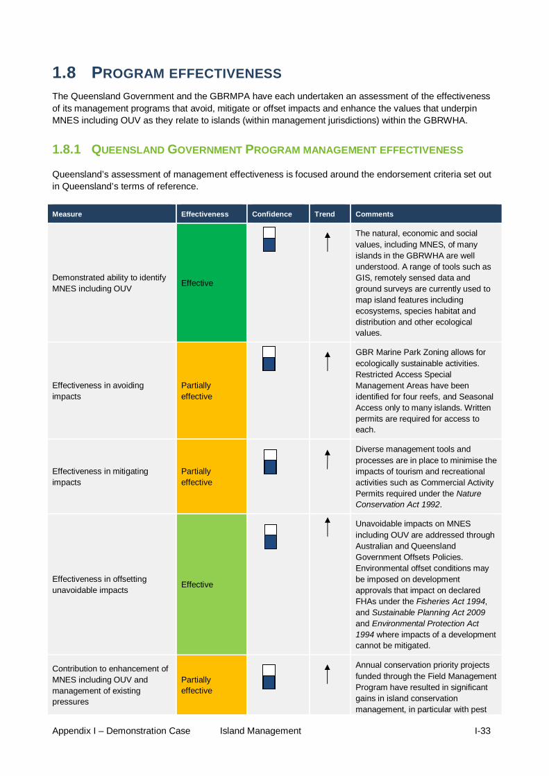
Appendix I – Demonstration Case Island Management I-33
1.8 PROGRAM EFFECTIVENESS The Queensland Government and the GBRMPA have each undertaken an assessment of the effectiveness of its management programs that avoid, mitigate or offset impacts and enhance the values that underpin MNES including OUV as they relate to islands (within management jurisdictions) within the GBRWHA.
1.8.1 QUEENSLAND GOVERNMENT PROGRAM MANAGEMENT EFFECTIVENESS
Queensland’s assessment of management effectiveness is focused around the endorsement criteria set out in Queensland’s terms of reference.
Measure Effectiveness Confidence Trend Comments
Demonstrated ability to identify MNES including OUV Effective
The natural, economic and social values, including MNES, of many islands in the GBRWHA are well understood. A range of tools such as GIS, remotely sensed data and ground surveys are currently used to map island features including ecosystems, species habitat and distribution and other ecological values.
Effectiveness in avoiding impacts
Partially effective
GBR Marine Park Zoning allows for ecologically sustainable activities. Restricted Access Special Management Areas have been identified for four reefs, and Seasonal Access only to many islands. Written permits are required for access to each.
Effectiveness in mitigating impacts
Partially effective
Diverse management tools and processes are in place to minimise the impacts of tourism and recreational activities such as Commercial Activity Permits required under the Nature Conservation Act 1992.
Effectiveness in offsetting unavoidable impacts Effective
Unavoidable impacts on MNES including OUV are addressed through Australian and Queensland Government Offsets Policies. Environmental offset conditions may be imposed on development approvals that impact on declared FHAs under the Fisheries Act 1994, and Sustainable Planning Act 2009 and Environmental Protection Act 1994 where impacts of a development cannot be mitigated.
Contribution to enhancement of MNES including OUV and management of existing pressures
Partially effective
Annual conservation priority projects funded through the Field Management Program have resulted in significant gains in island conservation management, in particular with pest

Appendix I – Demonstration Case Island Management I-34
Measure Effectiveness Confidence Trend Comments
eradication. Adaptive management strategies such as those developed on Raine Island have built more resilient northern GBR green turtle and sea bird populations. Lady Elliot Island vegetation management plan will assist to control weeds and regenerate natural species addressing the particular concern of nesting birds and turtles
Demonstrated ability to adapt system over time to incorporate new knowledge
Effective
The QPWS Management Effectiveness Evaluation System applies an adaptive management approach to improve management of protected areas including islands. Elements of the system such as Park Folios provide a living record of data for QPWS estate areas and define park values and desired condition. Two special management areas have been designated for species conservation and resources relevant to islands providing a responsive and adaptive approach to implementing management strategies.
Resourcing, monitoring and compliance
Partially effective
The Intergovernmental Agreement requires the development of a rolling five year Field Management Business Strategy to direct the activities of the Field Management Program across the GBRWHA. There are currently four effective island based monitoring programs supported by the Field Management Program. Resource limitations, the remote location of many islands and ecological and jurisdictional complexities restrict the extent of some monitoring activities.
Overall effectiveness Effective
In general, the condition of the islands managed by the GBRMPA and QPWS was assessed as stable with processes in place to manage impacts.

Appendix I – Demonstration Case Island Management I-35
1.8.2 AUSTRALIAN GOVERNMENT MANAGEMENT EFFECTIVENESS
Figure 1.8-1 The management cycle
The effectiveness of the GBRMPA program to achieve desired results for each of the six elements were qualitatively assessed on a four point rating scale (A (81 – 100 per cent); B (51 – 80 per cent); C (21 – 50 per cent); D (1 – 20 per cent)) and graded (effective; mostly effective; partially effective; ineffective).
The self-assessment concluded that management actions were mostly satisfactory across six evaluation criteria but there were deficiencies, and the peer review generally endorsed the self-assessment (Table 1.8-1; Figure 1.8-1). Management is mostly effective across five of the elements, but is only partially effective for inputs, which reflects the resource-limited environment that management of nearly 500 islands must contend with.
Recommendation 6.2.1 in the review panel’s report is relevant to this demonstration case:
Undertake a comprehensive assessment to determine the resourcing required to implement key programs.
Identify resourcing needs for activities of greatest importance to island conservation, particularly for remote and isolated locations and seek secure long-term funding for these activities. This includes the capacity to access islands on a regular basis, and to be able to undertake programs of work that may require extended ranger presence (i.e. for more than a few hours). Identifying resource needs specific to island conservation may assist in targeting specific funding for relevant activities but within an overall understanding of resource needs for effective management of the Region.

Appendix I – Demonstration Case Island Management I-36
Table 1.8-1 Assessment of management effectiveness for islands
Criteria Discussion Grade Self assessment
Grade Independently reviewed
Context There are 1050 islands consisting of 300 coral cays, 600 continental Islands and 105 mangrove Islands in the GBRWHA. Most are under Queensland Government jurisdiction; only 70 islands or parts of islands are under Australian Government control. The majority of the islands are important refuges for terrestrial and marine species such as turtles and seabirds which use islands and cays for nesting. Islands are also highly valued culturally, aesthetically and for recreation and tourism. The importance of Traditional Owner connections to land and sea country are also recognised. Approximately 330 islands are protected as National Parks, but there are some islands with high nature conservation value that are not under protected area tenure (e.g. Douglas Islets in the Far North). Maintaining the natural, economic and social values of these islands relies on a good knowledge of values, identifying changes and trends and managing threats to these values. The key known threats to the natural, economic and social values of the islands within the GBRWHA are: the ecosystem consequences of a changing climate; invasive plant and animal pests; altered and unmanaged fire regimes; impacts to island natural and recreational values from human use; and the degradation of cultural heritage (Indigenous and non-Indigenous). There is a good understanding of direct and indirect impacts on islands by a number of expert staff. Management plans or management statements are in place for all island National Parks (or National Park island groups). These summarise key context information and use this as a basis for management recommendations. A number of national park islands also have detailed Park Folios that capture information on values, threats, treatments and human use. This knowledge base could be further extended and would also benefit if was further integrated in agency wide knowledge management systems, especially with spatial data. While most of the potential threats to protected area island ecosystem integrity are understood, data gaps are recognised for current ecological status and trend of some islands. The capacity to consistently monitor and report on island condition and trend and to plan response treatments strategically across the GBRWHA is constrained. There is no island equivalent of the Australian Institute of Marine Science (AIMS) reef long-term monitoring program and currently islands are not a significant consideration in the GBR Outlook Report. Strengthening island condition and trend monitoring and reporting would support a complete adaptive management approach for islands and deliver more resilient island ecosystems. It would also complement the existing marine ecosystem condition and trend monitoring arrangements, providing a balanced overall assessment for the GBRWHA.
B – Mostly effective 51 – 80 %
Mostly effective Endorsed

Appendix I – Demonstration Case Island Management I-37
Criteria Discussion Grade Self assessment
Grade Independently reviewed
Planning Planning arrangements for island management across the GBRWHA are complex, due to the diverse mix of values they support (biodiversity, cultural heritage and socio-economic (community values), sheer number, geographic spread and multiple jurisdictions. Effective cooperation between various managing agencies involved in island management is essential and effective governance arrangements are currently in place, but cooperation mechanisms inevitably increase transaction costs. A large array of planning tools are in place to manage islands and include complementary State-Australian Government zoning plans (with specific zoning for all Commonwealth Islands) and Special Management Areas, joint Field Management Business Plans (which include island on-ground managements actions), Great Barrier Reef Marine Park Plans of Management (Whitsunday, Hinchinbrook, Cairns and Shoalwater Bay), and State Management Plans and Park Folios for island National Parks. This array of planning tools provides clear direction regarding the types of activities allowed and the conditions under which they may proceed. However, they could be better aligned to achieve administrative efficiencies and would benefit from further consultation between agencies (and particularly local governments, where relevant) during development stages. Currently, many site planning arrangements are developed reactively, to respond to a specific issue that has emerged (especially for high use sites); planning needs to be more strategic to prevent unacceptable impacts from visitation. This is especially relevant to the southern area of the GBRWHA. Commonwealth-managed Islands (or parts thereof) within the statutory Plan of Management Areas have statutory planning provisions, a comprehensive Commonwealth Islands database and a preliminary Heritage Register. In addition one Commonwealth Island (Lady Elliott Island) currently has an approved Heritage Management Plan under the Environment Protection and Biodiversity Conservation Act 1999. This is a requirement for islands that are specifically on the Australian Government Heritage list; those on that list without an approved plan, have either draft Heritage Management Plans (Dent Island) or draft management statements (Low Isles, Pine islet and North West Island). A number of GBRMPA policies and position statements are also directly or indirectly relevant to islands (e.g. Guidelines for Managing Visitation to Seabird Breeding Islands). Site specific planning is in place for some islands with conflicting human-use issues (e.g. tourist flights in the vicinity of Magnetic Island) and islands of high conservation and traditional value (e.g. Restricted Access Special Management Areas surrounding Raine Island, Moulter Cay and MacLennan Cay). However, some very important aspects of island management, particularly the prevention of pest and weed invasion through biosecurity measures, are not being comprehensively addressed, due to a lack of regulatory power, and/or little compliance and enforcement of activities that occur on the mainland (such as loading of barges) which is a clear risk to island ecosystems. The draft Great Barrier Reef Biodiversity Conservation Strategy 2012,63 and the draft Vulnerability Assessment of islands may support more effective planning for islands, but need to be complemented by clear management objectives across the three tiers of government (Commonwealth, State and Local); to facilitate consistency in planning for islands and confidence by stakeholders and the community. This is particularly crucial for near-shore islands, which are especially vulnerable to impacts from coastal development, port expansion,
B – Mostly effective 51 – 80 %
Mostly effective Endorsed

Appendix I – Demonstration Case Island Management I-38
Criteria Discussion Grade Self assessment
Grade Independently reviewed
Inputs Given the sheer number of islands within the GBRWHA and the remote nature of some, the resources required to manage them effectively are significant. At present field management resources struggle to achieve an appropriate management regime, especially for high conservation value and high presentation value sites in distant/remote locations of the GBRWHA where on-site ranger presence may total only a few hours per year. In particular, a rescue package for Raine Island is needed to reverse its ecological decline and support the world's most significant green turtle rookery. There is also a long-standing shortage of resources dedicated to the identification and protection of cultural heritage, which has resulted in the deterioration of some sites. The regulatory obligations associated with heritage on islands, which include Heritage Management Plans for specific sites and a GBR Heritage Register, are slowly being developed, with various outputs yet to be finalised. The differing heritage requirements that exist under Australian and Queensland government legislation are a confounding factor that inhibits effective protection of heritage matters on islands. Most management measures in place in the Marine Park affect islands directly (e.g. visitor management on islands) or indirectly (e.g. oil pollution response plan), so it is difficult to quantify resource expenditure for island management. This is made more complex by the involvement of three levels of governments and private leaseholders. The joint Field Management Program is the core program for Protected Area island management. It adopts a risk-based approach to ensure islands are monitored, assessed and maintained for ecological values, public appreciation and enjoyment. The Program currently receives $17 million a year but this funding only allows a small percentage of islands to be visited annually, and in some cases for as little as two hours at a time (see outputs for further statistics). Recently $150 000 per year of this funding was set aside to undertake ‘Conservation and Natural Resource Management Priority Projects’. This approach has progressed on-ground actions towards highest threat/highest probability of ecological gain on protected area islands. Overall, significant expertise and skill sets exist in both organisations but this is not widespread across all the necessary staff. However better integration is required between experts in different areas of island management (irrespective of jurisdiction) or different levels of government to reduce duplication in resources and effort, particularly at the planning level. There is also a shortage of expertise in some specific areas of island management relating to tenure systems for Commonwealth Islands, and Indigenous and non-Indigenous heritage, which are not currently being appropriately considered at the planning and joint-permit assessment stages of management. Although a wide range of information on islands is available to managers both through scientific research (particularly on geomorphology), desktop assessments (e.g. draft Vulnerability Assessment for islands), and monitoring programs (e.g. coastal birds, turtles and Pisonia forests monitoring programs) many gaps in knowledge remain, particularly on
C – Partially effective 21 – 50 %
Partially effective Endorsed

Appendix I – Demonstration Case Island Management I-39
Criteria Discussion Grade Self assessment
Grade Independently reviewed
incremental/cumulative impacts, rare and endangered species and the dynamics of key ecological attributes . An Australian Government funded research project is currently underway to help managers prioritize management actions for multiple objectives across GBR islands. The project will inform a field management annual business plan and guide financial and human inputs, optimising environmental returns for available funds.
Process An engaged and supportive community is vital to the long-term protection of the GBRWHA, including its islands. The Authority has established frameworks through Reef Advisory Committees, Local Marine Advisory Committees, Sea Country Partnerships and Reef Guardian Programs to ensure stakeholders are engaged in management of islands. The Queensland Government has initiated a program to increase the support that community volunteers can provide to the management of the State’s protected areas (this program will need ongoing support and augmentation if volunteer response grows). The governance system for GBR islands is extremely complex, involving many stakeholders and all levels of government. On-ground management and compliance activities are well integrated, due to collaborative mechanisms established between the Queensland and Australian governments through the Intergovernmental Agreement. Linkages have also been established between the Authority and other departments (such as the Australian Maritime Safety Authority for European heritage sites). However, stronger linkages are needed at the policy and planning levels (particularly for biosecurity), to ensure consistency between island managed by the Queensland Government (protected area estate islands – 330) and islands managed by the Australian Government (70 Islands of which the GBRMPA only manages 20). This is particularly important for islands with multiple jurisdictions managed by both governments (such as Dent and Penrith Islands). Direct and indirect impacts affecting islands, such as pest and weed invasions, visitor impacts and habitat loss through infrastructure development are generally well understood by managers. Island stakeholders (such as recreational visitors, researchers, leaseholders, traditional owners and tourism operators) are clearly identified and effectively engaged in island management: managers and rangers regularly interacting with stakeholders at all stages of the management cycle (from policy development through to compliance). However, better communication strategies are needed to increase visitor awareness on best practice and the conservation of values associated with islands. Existing work with Traditional Owners through the Sea Country Partnerships Grants Program is due to end in June 2013. Continuation of this process is needed to ensure Traditional Owners continue to be engaged in natural resource management on islands with high cultural value. The Outlook reporting cycle does not specifically assess island management. The Field Management Program uses two priority setting systems to assess National Park islands (the QPWS Park Categories System and the Field Management Program Island Risk Assessment
B – Mostly effective 51 – 80 %
Mostly effective Endorsed

Appendix I – Demonstration Case Island Management I-40
Criteria Discussion Grade Self assessment
Grade Independently reviewed
System). Strategic Fire and Pest Management Programs have also been developed which include an evaluation processes. In combination with a Rapid Assessment Program, these Queensland Government processes provide targets to benchmark management performance against, and establish priorities for funding. However some of these evaluation exercises (such as Parks Profiles) only apply to some islands within the GBRWHA, and do not inform or sit under a broader management evaluation system for all islands within the Reef. The aforementioned Australian Government funded research program will implement an explicit decision-making framework for cost-effectively investing in island management actions as a pilot study in the southern GBRWHA to address this gap.
Outputs Activities relating to island management have generally progressed well, and in accordance with the respective work programs (e.g. the Field Management program, the Queensland Parks Profiles system). A number positive outputs have been achieved on those islands within the protected islands estate, including:
island maintenance database development Commonwealth Islands database and other components of the draft Heritage Register regular seabird censuses on important seabird breeding sites regular planned burning provision of visitor facilities and amenities such as boardwalks, lookouts or signage the regular maintenance of public moorings around islands successful eradication of pests (e.g. removal of rats from Boydong islands, eradication
of feral pigs from Wild Duck island Pisonia forest recovery on Tryon Island
However, resource constraints, in combination with the remote locations of some of the islands, limit compliance and enforcement activities, and inhibit the achievement of stated management objectives. For example, while the total time spent on Far Northern Islands increased significantly in the past few years (from seven days in 2004 to 55 days in 2009), on average only 30 of the 70 islands in the Far Northern area were visited on a patrol each year, and even then resources limited the island visit to two hours on average. This is insufficient time to conduct all activities required to maintain and improve island values, such as pest and weed eradication, facilities maintenance and fire management. As a consequence, weeds and pests have not been properly contained in some of these remote islands. In addition, some heritage sites have become dilapidated (in particular Pine Islet light station), and their aesthetic value and integrity have been negatively affected. In other instances, outputs have had unintended adverse impacts: for example, mitigation measures to prevent erosion have resulted in adverse impacts on other parts of Green and Heron islands. A holistic process and adequate resourcing that integrates all aspects of island/sea management are needed. Processes also need to take
B – Mostly Effective 51 – 80 %
Mostly effective Endorsed

Appendix I – Demonstration Case Island Management I-41
Criteria Discussion Grade Self assessment
Grade Independently reviewed
into account cumulative pressures (including climate change impacts) and potential changes in ocean currents and migration patterns (especially for cays/beaches) to ensure important habitats for feeding and breeding are afforded appropriate levels of protection.
Outcomes
Although it is difficult to track specific outcomes resulting from management actions for islands and cays, outputs have focussed on the reduction of short-term, direct pressures (e.g. weed or pest incursions) rather than cumulative or long-term pressures (e.g. changes in beach profiles at Raine Island that reduce turtle egg hatching success). Islands are particularly vulnerable to climate change impacts which may enhance the spread of exotic species, lead to increased shoreline erosion, and affect the stability of some vegetated islands due to a change in rainfall patterns. The major threat of climate change to islands has been partly considered in some planning tools (e.g. the Climate Change Action Plan, Raine Island Resilience Plan), and significant progress has been made to increase the resilience of a small number of islands. However climate change has not been considered systematically for all islands. Other activities such as coastal development (exacerbating flood plumes and habitat loss) and shipping (increase in marine debris and reduction in aesthetic values) provide major challenges for island management. These activities have not been systematically considered in the planning regime for islands, meaning that outputs have not necessarily addressed the major risks and threats for islands.
Outcomes: Total Protected Area Estate Islands and Commonwealth Islands B – Mostly Effective 51 – 80 %
Outcomes: Biodiversity Protected Area Estate Islands and Commonwealth Islands B – Mostly Effective (but declining) 51 – 80 %
Outcomes: Total Protected Area Estate Islands and Commonwealth Islands B - Mostly Effective Endorsed
Outcomes: Biodiversity Protected Area Estate Islands and Commonwealth Islands B - Mostly Effective Endorsed
Non-Protected Area Islands C – Partially effective 21 – 50 %
Non-Protected Area Islands C – Partially effective 21 – 50 %
Non-Protected Area Islands Not assessed
Non-Protected Area Islands Not assessed

Appendix I – Demonstration Case Island Management I-42
1.9 PROJECTED CONDITION OF MNES, INCLUDING OUV The projected condition of biodiversity, heritage and socio-economic values of islands in the GBRWHA is a function of their current condition, their intrinsic ability to maintain condition or recover from disturbance, and the likelihood and consequence that impacts will either increase or decrease (which is a function of drivers, and our ability to avoid or mitigate future impacts). Drivers, activities and impacts form a complex web of interactions which affect islands, as described in detail in the Strategic assessment report. The vast majority of impacts identified as risks are assessed as increasing into the future, as the pressure from all drivers are likely to increase. In the absence of more effective management, the condition of values on islands is projected to decline.
1.9.1 DRIVERS
1.9.1.1 POPULATION AND ECONOMIC GROWTH Australia’s coastal population is growing more rapidly than the population in other parts of the country and is expected to increase over the coming years. Average annual population growth of two per cent per year is expected in the GBR catchment with the majority of people living near or on the coastal area. Increased demand for infrastructure and services resulting from this growth may impact and/or modify the coastal environment.
1.9.1.2 CLIMATE CHANGE The vulnerability of islands and their biota to climate change has been extensively reviewed elsewhere. Climate change can affect islands in different ways. The interaction of sea level rise, increased air and water temperatures, precipitation intensity, changes in El Niño/La Niña cycles may severely affect some islands. However, reef islands have an intrinsic adaptive capacity to adjust to climate change. Their dynamic nature means they will continue to move and be periodically removed by naturally variable climatic and sea level conditions. It is likely that in the short term at least, some GBR islands will adjust to rising sea levels, more intense cyclones, and modified rainfall regimes by getting larger or higher. Variable responses will occur that largely reflected differences in reef platform elevation, sediment supply, water tables and hydrodynamic setting, so that regional patterns may emerge.
1.9.1.3 OCEAN ACIDIFICATION The continued building and persistence of coral cays will depend largely on the ongoing capacity of reef organisms to produce calcium carbonate (limestone) material. Active carbonate production and reef island accumulation are more tightly coupled on less emergent reef flats. In these circumstances, diminished carbonate productivity and sediment supply will have more immediate effects on island sediment budgets and morphologies.
Coral bleaching caused by increasing sea temperatures, in combination with ocean acidification, is expected to greatly reduce the production of limestone shells and skeletons over coming decades. Whether calcium carbonate production by less sensitive organisms can compensate for the expected loss of hard corals, and how the dynamics of coral cays are affected is not known.
1.9.1.4 RISING SEA LEVEL The entire GBR and adjacent coast have experienced massive and repeated environmental changes in the recent geological past. Such changes have included sea level rises of over 100 metres since the peak of the last ice age.
The impacts of sea level rise on islands and cays are not straightforward. Coral cays are vulnerable to climate change stressors because they form by accumulation of sediments. This process will be affected by
Appendix I – Demonstration Case Island Management I-43
sea level rise and any increase in storm intensity. Whether low-lying islands are likely to be inundated over time, or whether they will grow to keep pace with rising sea levels (at least in the short-term) depends on a number of factors. For example, coral cays are built from a continuous accumulation of sand fetched across a reef by wave action. Whether the cay can continue to grow depends on there being an ongoing source of sand and coral rubble. Scientists predict that the sea level rise over the course of this century may actually lead to an increase in the size and number of coral cays on the GBR in the short-term. Non-vegetated cays on exposed reefs in areas of high tidal range are the most vulnerable to sea level rise and will switch to an erosion phase at the lowest thresholds. Vegetated cays with lithified shores and interiors on emergent reefs platform are likely to be more resilient, subject to saltwater intrusion.
With a rise of around one metre, most low-lying islands and cays are likely to be inundated, which will cause problems for plants and animals, such as inundation of breeding and nesting sites, and seawater intrusion into fresh groundwater sources. Increased sea level would also reduce the beach area available to sea turtles for nesting.
1.9.1.5 INCREASED AIR AND SEA TEMPERATURE Increased sea surface temperatures will probably lead to an increase in coral mortality. In the short-term, this may create a pulse of available sediment for island consolidation.
Warmer air temperatures are likely to favour drought- and fire-adapted plants, although this will depend on changes to rainfall. In a warmer climate, certain diseases, and many weeds (e.g. lantana) appear to be at an advantage. Animals will be affected as well. For example, higher sand temperatures can alter the sex ratio of turtle hatchlings. The isolation of many GBR islands may also inhibit the natural southward migration of animals and plants as temperatures rise.
1.9.1.6 CHANGES IN RAINFALL PATTERNS The stability and geomorphology of some vegetated islands could also be at risk by changes in rainfall patterns. Regional changes to rainfall patterns will play an important role in determining how island habitats respond to climate change. Increased or decreased rainfall, or changes to the timing of rainfall, would greatly alter the fire risk on islands. Some animal and plant communities on islands and cays will degrade over time if aquifers are not replenished. Specific changes will depend on the combined effects of changing rainfall, drought and fire regimes resulting from climate change. Changing temperatures and rainfall patterns may cause changes in island vegetation and could increase pest species abundance too.

Appendix I – Demonstration Case Island Management I-44
1.10 POSSIBLE IMPROVEMENTS TO THE PROGRAM The following comments relate to the protected area islands (e.g. National park or other conservation tenures) of the GBRWHA and islands that are part of the GBR Marine Park. These together make up about 45 per cent of the total of 1050 islands within the GBRWHA. Many of the identified management improvements would also benefit non-protected area islands.
Maintaining the natural, economic, cultural and social values of these islands relies on a good knowledge of values, identifying changes and trends and managing threats to these values. The key known threats to the natural, economic, cultural and social values of GBRWHA islands in varying degrees are: the ecosystem consequences of a changing climate; invasive plant and animal pests; altered and unmanaged fire regimes; impacts to island natural and recreational values if human use is not well-managed; and the degradation of cultural heritage (Indigenous and non-Indigenous). Possible Program improvements that address these threats are detailed in the following sections.
10.1 CONDITION AND TREND MONITORING AND REPORTING
While managers generally understand most of the potential threats to protected area island ecosystem integrity, the capacity to consistently monitor and report on island condition and trend and to plan response treatments strategically across the GBRWHA, is constrained. There is no island equivalent of the Australian Institute of Marine Science (AIMS) reef long-term monitoring program and currently islands are not a significant consideration in the GBR Outlook report. Strengthening island condition and trend monitoring and reporting would support a complete adaptive management approach for islands and deliver more resilient island ecosystems. It would also complement the existing marine ecosystem condition and trend monitoring arrangements, providing a balanced overall assessment for the GBRWHA.
10.2 FIELD MANAGEMENT ON-GROUND CAPACITY
On ground management actions are essential in ensuring management effectiveness for protected area islands, whether this be maintaining visitor infrastructure, managing pest plants and animals and fire or active adaptive management works to remove or reduce threats to vulnerable species such as marine turtles and seabirds. It is the input dimension that has most constraint on achieving management effectiveness for island protected area management. Improved field management resources, personnel and fit-for-purpose vessels to deploy to all protected area islands at the frequency and duration required for effective on-ground management would improve the protection of natural, social, cultural and economic values of island protected areas. At present field management resources struggle to achieve an appropriate management regime, especially for high conservation value and high presentation value sites in distant/remote locations of the GBRWHA where on-site ranger presence may total only a few hours per year.
10.3 BIOSECURITY
More comprehensive management of island biosecurity should be considered. The present management framework does a good job of controlling or eradicating pest plants and animals at locations where resources are focussed on resolving specific issues. However, there is not as strong a focus in relation to the two other dimensions of biosecurity – quarantine and surveillance. Prevention or early detection and treatment for island pests are more effective and less expensive than cure. While there remain many historical pest legacy issues requiring management action, the factors that drive island pest introductions are escalating (such an expanding visitation footprint from an expanding coastal population).

Appendix I – Demonstration Case Island Management I-45
10.4 RECREATION AND TOURISM OPPORTUNITIES/FACILITIES Island protected areas will continue to provide visitor opportunities that support a vibrant tourism industry and a broad and expanding range of recreational use. As the coastal population increases, so too will the demand for visitor opportunities and the associated facilities required to support this use and minimise its impacts on island and reef ecosystems. Having a program with the capacity for good regional and site-specific tourism and recreation planning (including infrastructure planning) that stays ahead of the demand curve will be important. This will sustain visitor enjoyment, environmental quality and the economic benefits of healthy, well-presented islands.
10.5 VOLUNTEERS An engaged and supportive community is vital to the long-term protection of the GBRWHA, including its islands. The Queensland Government has initiated a program to increase the support that community volunteers can provide to the management of the State’s protected areas. It is desirable that this program be supported and augmented as needed to boost the role of volunteers in managing GBRWHA islands.
10.6 CULTURAL HERITAGE PROTECTION The Program needs field management resources that are aware of and trained to deal with cultural heritage management. At present the current management resources struggle to achieve this effectively with competing priorities to manage natural values, tourism and recreation. Some cultural heritage sites are known to be degrading e.g. Pine Islet lightstation has been closed to public access due to asbestos issues. With European heritage sites, in particular, the costs are high to adequately maintain these long term (e.g. the Queensland Government heritage listed Raine Island Tower and the National heritage listed Lady Elliot Island Lighthouse). The Australian Government agency responsible for National heritage sites listed under the EPBC Act must make plans to protect and manage their National Heritage values and must not contravene those plans. Future improvements should consider closing the current gap in capacity to fully deliver on heritage protection obligations.
10.7 TRADITIONAL OWNER PARTNERSHIPS The Program has made significant progress in recent years in the arena of partnerships with Traditional Owners, especially through the collaborative development of TUMRAs and ILUAs. Specific Indigenous compliance partnerships have also been progressed on Cape York Peninsula. The Australian Government Reef Rescue funding package has been a key driver of this progress. This package is for a specific term and will terminate in 2013. A focussed program for Traditional Owner partnerships specifically related to island protected area management would complement the progress that has been made with Traditional Owners. This has been primarily in the marine resource management arena and in formal joint management under National Park, Cape York Peninsula Aboriginal Land arrangements
10.8 RESILIENCE AND ADAPTIVE MANAGEMENT A fundamental principle for management of island protected areas is the maintenance of well-functioning ecosystems. This approach is consistent with that recommended in Australia’s Biodiversity and Climate Change Vulnerability Assessment (2009) which states under the strategy of Building Resilience: ‘...the single most important adaptation strategy is the maintenance of well-functioning ecosystems.’ This focus on resilience-based management of islands should continue as an important component of the Program’s strategy. Climate change amplifies the disturbance regime in natural systems, with no exception regarding impacts on island ecosystems. However, predicting the exact manifestation of island impacts over the next 25 years is difficult. It is therefore important that the forward Program for island management has a strong capacity for adaptive governance. This could include the capacity to use island condition and trend information to adjust on-ground actions and mitigate climate change impacts. Over the next 25 years this could involve unprecedented management interventions to protect or recover specific locations, habitats or species.

Appendix I – Demonstration Case Island Management I-46
1.11 KEY OUTCOMES AND LEARNINGS FROM THE DEMONSTRATION CASE
In general, the condition of islands managed by the GBRMPA and QPWS was assessed as good and stable, with the exception that condition is deteriorating on some inner islands that are the subject of development activities in the southern GBRWHA.
Many of the natural resource management issues on islands have deep historical origins. Consequently, effective management needs to address past impacts as well as current and emerging threats to the islands and their surrounding marine ecosystems.
Key challenges include resource limitations, the remote location of many islands (where visits by field staff may total only a few hours per year) and the ecological and jurisdictional complexities. These challenges were recognised in the establishment of joint management arrangements and a formal partnership between the Australian and Queensland governments through the former Emerald Agreement and the current Great Barrier Reef Intergovernmental Agreement 2009. Over more than 30 years, an extremely effective partnership has delivered day-to-day management through a field management team.
A large range of tools are available to manage islands, including complementary Australian and Queensland governments zoning through the Great Barrier Reef Marine Park Zoning Plan 2003, joint field management business plans, permitting arrangements, Great Barrier Reef Marine Park Plans of Management, and QPWS management plans and management statements for island National Parks.
Monitoring programs for coastal birds, turtles, plant and animal pests and fire are undertaken to assess the condition and trend of key species and habitats. Controlling or eradicating pest plants and animals is risk-based/priority-based and effective at locations where resources are focused. However, a strong focus on quarantine and surveillance is needed, as prevention of adverse environmental impacts is more cost-effective than trying to manage or reverse them.
The GBRMPA and the Department of Defence have responsibility for the protection of natural, historical and cultural heritage values on the 70 Commonwealth-owned islands. Regimes are in place to provide an overarching level of management for these islands (for example, zoning, regulations, surveillance and enforcement). However, a lack of information in a readily accessible format makes it difficult to monitor and assess the condition of those values and in some cases has contributed to delays in the preparation of heritage management plans.

Appendix I – Demonstration Case Island Management I-47
1.12 INFORMATION SOURCES Allaway, W.G. and Ashford, A.E. 1984, Nutrient input by seabirds to the forest on a coral island of the Great Barrier Reef, Marine Ecology Progress Series 19: 297-298.
Alongi, D.M. 2002, Present state and future of the world's mangrove forests, Environmental Conservation 29(3): 331-349.
Batianoff, G.N. 1997, Natural Heritage Attribute: Terrestrial Flora, in The outstanding universal value of the Great Barrier Reef World Heritage Area, eds P.H.C. Lucas, T. Webb, P.S. Valentine and H. Marsh, Great Barrier Reef Marine Park Authority, Australia, pp. 193-195.
Batianoff, G.N. and Dillewaard, H.A. 1996, Floristic analysis of the Great Barrier Reef continental islands, Queensland. in State of the Great Barrier Reef World Heritage Area, eds D. Wachenfeld, J. Oliver and K. Davis, Great Barrier Reef Marine Park Authority, Townsville, pp. 300-322.
Batianoff, G.N., Naylor, G.C., Olds, J. and Neldner, V.J. 2009, Distribution patterns, weed incursions and origins of terrestrial flora at the Capricorn-Bunker Islands, Great Barrier Reef, Australia, Cunninghamia 11(1): 107-121.
Capobianco, M., DeVriend, H.J., Nicholls, R.J. and Stive, M.J.E. 1999, Coastal area impact and vulnerability assessment: the point of view of a morphodynamic modeller, Journal of Coastal Research : 701-716.
Coles, R., Beumer, J., McKenzie, L. and Rasheed, M. 2005, Seagrass fisheries habitat in Queensland coastal waters and issues for their protection and management, in Rainforest meets reef: joint conference of CRC Reef and Rainforest CRC, 22-24 November 2005, Townsville: conference abstracts, eds. L. Goggin and T. Harvey. , CRC Reef Research Centre, Townsville, pp.29.
Congdon, B.C. 2008, Seabirds, in The Great Barrier Reef: biology, environment and management, eds P.A. Hutchings, M.J. Kingsford and O. Hoegh-Guldberg, CSIRO Publishing, Collingwood, pp. 359-368.
Couchman, D. and Beumer, J. 2007, Management and protection of marine plants and other tidal fish habitats, in Fish habitat management operational policy. Department of Primary Industries and Fisheries, Brisbane. 60pp.
Daley, B. 2005, Changes in the Great Barrier Reef since European settlement: implications for contemporary management, Ph.D. thesis, James Cook University, Townsville.
Defeo, O., McLachlan, A., Schoeman, D.S., Schlacher, T.A., Dugan, J., Jones, A., Lastra, M. and Scapini, F. 2009, Threats to sandy beach ecosystems: a review, Estuarine, Coastal and Shelf Science 81(1): 1-12.
Deloitte Access Economics Unpublished, Economic Contribution of the Great Barrier Reef 2011-2012 (December 2012), Great Barrier Reef Marine Park Authority, Townsville.
Department of Defence 2009, State of the Environment Report for Shoalwater Bay training area 2008, Department of Defence, Canberra.
Department of Defence and Great Barrier Reef Marine Park Authority 2008, Management agreement between Department of Defence and the Great Barrier Reef Marine Park Authority on implementation of the strategic environmental assessment of defence activities in the Great Barrier Reef Marine Park, Great Barrier Reef Marine Park Authority, Townsville.
Department of Primary Industries and Fisheries Declared fish habitat areas, <http://www.dpi.qld.gov.au/28_1238.htm> .

Appendix I – Demonstration Case Island Management I-48
Department of State Development, Infrastructure and Planning 2012, Great Barrier Reef Coastal Zone Strategic Assessment: background and final terms of reference, Department of State Development, Infrastructure and Planning, Brisbane.
Department of Sustainability, Environment, Water, Population and Communities 2010, EPBC Act policy statement 5.1: Magnetic Island, Queensland.
Duke, N. 1997, Mangroves in the Great Barrier Reef World Heritage Area: current status, long-term trends, management implications and research, in State of the Great Barrier Reef World Heritage Area Workshop, eds D. Wachenfeld, J.K. Oliver, K. Davis, J.K. Oliver and K. Davis, Townsville edn, Great Barrier Reef Marine Park Authority, Townsville, pp. 288-299.
Duke, N.C. 2011, Mangrove Islands, in Encyclopaedia of modern coral reefs: Structure, form and process, ed. D. Hopley, 1st edn, Springer, Netherlands, pp. 653-655.
Duke, N.C., Lawn, P., Roelfsema, C., Zahmel, K., Pedersen, D. and Tack, C. 2005, Changing coastlines in the Fitzroy Estuary - assessing historical change in coastal environments. in Fitzroy in Focus: coastal science for the Fitzroy region, eds B. Noble, A. Bell, P. Verway and J. Tilden, 2005th edn, Brisbane: Cooperative Research Centre for Coastal Zone, Estuary and Waterway Management., Australia, pp. 6-46.
Endean, R., Stephenson, W. and Kenny, R. 1956, The ecology and distribution of intertidal organisms on certain islands off the Queensland coast, Marine and Freshwater Research 7(3): 317-342.
Fish, M.R., Cote, I.M., Gill, J.A., Jones, A.P., Renshoff, S. and Watkinson, A.R. 2005, Predicting the Impact of Sea-Level Rise on Caribbean Sea Turtle Nesting Habitat, Conservation Biology 19(2): 482-491.
Flood, P.G. 1974, Sand movements on Heron Island - A vegetated sand cay Great Barrier Reef Province, Australia, Proceedings of the Second International Coral Reef Symposium : 387-394.
Flood, P.G. 1986, Sensitivity of coral cays to climatic variations, southern Great Barrier Reef, Australia, Coral Reefs 5: 13-18.
Gandini, M. 2000, A report on the Terrestrial Vegetation of Low Isles. Queensland Department of Environment and Heritage, Port Douglass and James Cook University, Townsville.
Great Barrier Reef Marine Park Authority 1981, Nomination of the Great Barrier Reef by the Commonwealth of Australia for inclusion in the World Heritage List, Great Barrier Reef Marine Park Authority, Townsville.
Great Barrier Reef Marine Park Authority 2009, Great Barrier Reef Outlook Report 2009, GBRMPA, Townsville.
Great Barrier Reef Marine Park Authority 2012a, Great Barrier Reef Region Strategic Assessment Terms of Reference, GBRMPA, Townsville.
Great Barrier Reef Marine Park Authority 2012b, Great Barrier Reef Biodiversity Conservation Strategy (Draft), Great Barrier Reef Marine Park Authority, Townsville.
Great Barrier Reef Marine Park Authority 2013, Great Barrier Reef Region Strategic Assessment Report, Great Barrier Reef Marine Park Authority, Townsville.
Heatwole, H. 1991, Factors affecting the number of species of plants on islands of the Great Barrier Reef, 18(2): 213-221.
Heatwole, H. 1993, Class Reptilia: snakes, turtles and lizards, in A coral reef handbook: a guide to the fauna, flora and geology of Heron Island and adjacent reefs and cays, eds P. Mather and I. Bennett, Surrey Beatty & Sons Pty Ltd.

Appendix I – Demonstration Case Island Management I-49
Heatwole, H., Done, T. and Cameron, E. 1981, Community ecology of a coral cay: A study of One-Tree Island, Great Barrier Reef, Australia, Dr W. Junk Publishers, The Hague.
Hockings, M., Gilligan, B. and Leverington, A. 2013, Assessment of management effectiveness for the strategic assessment of the Great Barrier Reef Region, Great Barrier Reef Marine Park Authority, Townsville.
Hopley, D. 1982, The geomorphology of the Great Barrier Reef: quaternary development of coral reefs, John Wiley & Sons, New York.
Hopley, D. 1997, Geology of reef islands of the Great Barrier Reef, Australia, in Geology and Hydrogeology of Carbonate Islands. Developments in Sedimentology 54, eds H.L. Vacher and T.M. Quinn, 1997th edn, Elsevier Science, London, pp. 835-866.
Hopley, D., Smithers, S. and Parnell, K.E. 2007, The geomorphology of the Great Barrier Reef: development, diversity and change, Cambridge University Press, Cambridge.
Hulsman, K., O'Neill, P.O. and Stokes, T. 1997, Current status and trends of seabirds on the Great Barrier Reef, Great Barrier Reef Marine Park Authority, Townsville.
Hulsman, K., O'Neill, P., Stokes, T. and Warnett, M. 1997, Threats, status, trends and management of seabirds on the Great Barrier Reef, in The Great Barrier Reef, science, use and management : a national conference : proceedings, eds J. Campbell and C. Dalliston, Great Barrier Reef Marine Park Authority, Townsville, pp. 164-177.
King, B.R. 1993, The status of Queensland seabirds, Corella 17(3): 65-92.
Limpus, C.J. 2008, A biological review of Australian marine turtle species. 2. Green turtle, Chelonia mydas (Linnaeus), Environmental Protection Agency, Brisbane.
Limpus, C.J., Limpus, D.J., Munchow, M. and Barnes, P. 2005, Queensland turtle conservation project: Raine Island turtle study, 2004-2005, Environmental Protection Agency, Brisbane.
Limpus, C.J., Miller, J.D., Parmenter, C.J. and Limpus, D.J. 2003, The green turtle, Chelonia mydas, population of Raine Island and the northern Great Barrier Reef: 1843-2001, Memoirs of the Queensland Museum 49(1): 349-440.
Lucas, P.H.C., Webb, T., Valentine, P.S. and Marsh, H. 1997, The outstanding universal value of the Great Barrier Reef World Heritage Area, Great Barrier Reef Marine Park Authority, Townsville.
Miller, J.D. and Bell, I.P. 1995, Crocodiles in the Great Barrier Reef World Heritage Area, Paper presented to the State of the Great Barrier Reef World Heritage Area Report Technical Workshop, Townsville.
Miller, J. and Bell, I. 1997, Crocodiles in the Great Barrier Reef World Heritage Area, in State of the Great Barrier Reef World Heritage Area. Workshop Series No, eds. Anonymous, pp.248-255.
National Sea Change Taskforce 2010, A 10-point plan for coastal Australia: towards a sustainable future for our coast, National Sea Change Taskforce, Sydney.
Olds, J.A. 2006, Report on 2006 scale insect Pulvinaria urbicola outbreaks and Pest-Arrest project in the Capricornia Cays. Queensland Parks and Wildlife Service
Olds, J.A., Bell, K.L., and Elder, R.J. (in prep). Loss of the dominant Pisonia grandis forest on a coral cay due to soft scale, Pulvinaria urbicola (Cockerell) (Hemiptera, Coccidae). Submitted to Australian Journal of Entomolgy.
Olds, J.A., Elder, R.J., Charles, R.M., Platten, J.R., Bell, K.L. 1996. Pulvinaria urbicola (Cockerell) on Pisonia grandis at Tryon Island. The Great Barrier Reef Science, Use and Management. A National Conference. Proceedings: Posters Papers.

Appendix I – Demonstration Case Island Management I-50
Schlacher, T.A., Dugan, J., Schoeman, D.E., Lastra, M., Jones, A., Scapini, H., McLachlan, A. and Defeo, O. 2007, Sandy beaches at the brink, Diversity and Distributions 13(5): 556-560.
Schlacher, T.A. and Thompson, M.C. 2008, Physical Impacts Caused by Off-Road Vehicles to Sandy Beaches: Spatial Quantification of Car Tracks on an Australian Barrier Island, Journal of Coastal Research 24(2B): 234-242.
Smithers, S.G., Harvey, N., Hopley, D. and Woodroffe, C.D. 2007, Vulnerability of geomorphological features in the Great Barrier Reef to climate change, in Climate change and the Great Barrier Reef: a vulnerability assessment, eds J.E. Johnson and P.A. Marshall, Great Barrier Reef Marine Park Authority and Australian Greenhouse Office, Townsville, pp. 667-716.
Smithers, S.G. and Hopley, D. 2011, Coral cay classification and evolution, in Encyclopaedia of modern coral reefs: Structure, form and process, ed. D. Hopley, 1st edn, Springer, Netherlands, pp. 237-253.
Stoddart, D. 1991, Phytogeography and vegetation of the reef islands of the northern Great Barrier Reef.
Stokes, T., Dobbs, K., Mantel, P. and Pierce, S. 2004, Fauna and Flora of the Great Barrier Reef World Heritage Area. Great Barrier Reef Marine Park Authority, Townsville.
Turner, M. and Batianoff, G.N. 2007, Vulnerability of island flora and fauna of the Great Barrier Reef to climate change, in Climate change and the Great Barrier Reef: a vulnerability assessment, eds J.E. Johnson and P.A. Marshall, Great Barrier Reef Marine Park Authority and Australian Greenhouse Office, Townsville, pp. 621-666.
Turner, M., Green, R. and Chin, A. 2006, Birds, in The state of the Great Barrier Reef online, ed. A. Chin, Great Barrier Reef Marine Park Authority, Townsville.
Wace, N. 1996, Ocean litter stranded on Australian coasts, in The state of the marine environment report for Australia, technical anex 2: Pollution, eds L.P. Zann and D.C. Sutton, DEST, Canberra, pp. 73-87.
Wachenfeld, D., Oliver, J.K. and Morrissey, J.I. (eds) 1998, State of the Great Barrier Reef World Heritage Area 1998, Great Barrier Reef Marine Park Authority, Townsville.
Walker, T.A. 1987, Birds of Bushy Island (with summary of the nesting status of bird species on the southern Great Barrier Reef cays), Sunbird 17: 2-58.
Walker, T.A. 1991, Pisonia islands of the Great Barrier Reef, I. Distribution, abundance and dispersal by seabirds of Pisonia grandis , Atoll Research Bulletin 350: 1-23.
WBM Oceanics Australia and Claridge, G 1997, Guidelines for Managing Visitation to Seabirds Breeding Islands, Great Barrier Reef Marine Park Authority, Townsville.
Woodroffe, C.D. 2008, Reef-island topography and the vulnerability of atolls to sea-level rise, Global and Planetary Change 62: 77-96.
Zeppel, H. 2010, Sustainable tourism on Green Island, Great Barrier Reef Marine Park, in Island tourism: a sustainable perspective, eds J. Carlson and R. Butler, CABI, Oxfordshire, UK, pp. 38-53.
Zeppel, H. 2011, Collaborative governance for low-carbon tourism: climate change initiatives by Australian tourism agencies, Current Issues in Tourism in press.

Appendix I – Demonstration Case Island Management I-51
1.13 APPENDICES
APPENDIX 1 GEOLOGY AND GEOGRAPHY OF ISLANDS
1.13.1.1 MANGROVE ISLANDS There are 150 mangrove islands within the GBRWHA. These islands are principally vegetated by mangrove plants, and are often found in sheltered locations such as river mouths along the mainland within the GBRWHA. These islands are not typical islands as they lack terrestrial mass. Instead they are generally accumulated mud or sand with much of the land submerged at high tide. Extensive areas of island mangrove habitat occur in the Jacky Jacky Creek/Newcastle Bay Region, the Hinchinbrook Island region including the Hinchinbrook Channel, Broadsound/Shoalwater Bay, the Fitzroy estuary, and The Narrows and around the Colosseum Inlet. In some areas (such as the mouth of the Fitzroy River) the number of mangrove islands is increasing which has been attributed to the clearing and disturbance of catchment vegetation and subsequent downstream deposition of sediment. High reef flats in areas of low to moderate tidal range also provide suitable conditions for mangroves to settle, but these are considered to be low wooded islands herein.
1.13.1.2 CONTINENTAL ISLANDS At least 73 per cent of the islands found within the GBRWHA are continental islands. Most continental islands are mountainous outcrops located relatively close to the coast (3–120 kilometers) that are geologically similar to the adjacent mainland. In most cases they were connected to the mainland but were separated by sea level rise after the last ice glacial maximum of the Holocene. Continental islands are shaped by geological structure and wave action. Many continental islands have sandy beaches, particularly in leeward embayments. Some beaches are fringed by reef and dominated by carbonate sediments (for example, the north-west end of Curacoa Island). Others are dominated by terrigenous sediments and have no fringing reef offshore (for example, Horseshoe Bay on Magnetic Island). Beach rock is common on carbonate rich beaches, with lithified sediments varying from sands through to coarser shingle and rubble. Vegetation cover on continental islands ranges from grasses and shrubs to dense vine forest.
Continental islands mainly found through the central and southern areas of the GBR, and more than half are located between 20oS and 22oS (Shoal Point to Bowen). The majority of continental islands occur on the inner shelf, with the exception of those in southern areas of the GBRWHA (Mackay/Capricorn area) where they are more commonly found on the mid shelf. The largest continental islands in the GBRWHA are Curtis Island (90 square kilometres), Hinchinbrook Island (40 square kilometres) and Whitsunday Island (11 square kilometres).
1.13.1.3 REEF ISLANDS OR CORAL CAYS Reef islands occur on 10 per cent of all reef platforms in the GBRWHA and are formed by coral, sand and shingle deposition. Most reef islands are associated with planar reefs with high sediment cover. The materials are deposited by wave action on the reef flat forming coral cays. They are dynamic and change in shape and size constantly over time. Wave patterns determine the island's shape and structure: the contour of their reef refracts the waves and sand accumulates on the leeward side of the island. Historical sea level change, tidal range, type of reef and daily environmental conditions are the main factors that have influenced the distribution of reef islands. Reef island or coral cays are located mainly in the northern (north of 16o) and the southern (between 21o and 22o) parts of the GBRWHA, with fewer found in the central regions.
Unvegetated cays In the first stages of island development, these formations occur between the tide marks and have no vegetation. Unvegetated sand or shingle cays are the most common type of reef island and account for more than 70 per cent of all reef islands in the GBRWHA. They are usually the smallest and have the lowest relief of all island types. They are unstable, highly dynamic, and can migrate over several hundreds of meters of
Appendix I – Demonstration Case Island Management I-52
reef flat, changing in shape and height. They are often used as roosting sites by seabirds and migrating species. Unvegetated coral cays are found mostly to the north of Cairns, but occasionally are found in exposed locations, such as the southern Swains and the outer ribbon reefs, north of Lizard Island.
Vegetated cays Over time, sand can accumulate above sea level and may become vegetated. Such vegetation will assist in the stabilisation of the reef island in conjunction with deposited sand which solidifies over time through compaction although the island will remain dynamic as sand or shingle is eroded and deposited. Vegetated cays are common on inner reefs and the western ends of large midshelf reefs north of Cairns. In the southern GBR, the Capricorn Bunker Group forms a distinctive set of well vegetated islands. Vegetated cays are absent in the 640 kilometres of the GBR between Green Island, offshore Cairns to Bushy Island, east of Mackay, and in the 315 kilometres between Wheeler Reef, north of Townsville to Pompey Reef, off Mackay (Figure 1.1-1). This is believed to be a consequence of the historical sea level fluctuations during the Holocene and a lack of protection from normal and cyclonic wave energy.
Low wooded islands Low wooded islands within the GBR are the most complex of the reef islands in morphology, and exhibit a greater variety than the same type of reef islands in any other coral reef regions. They are composed of a windward shingle cay, a leeward sand cay and significant vegetative development over the reef top, and are unique to the GBR. As these are now more permanent structures, they are used for breeding activities by marine species such as seabirds and sea turtles.
The majority of the 44 wooded islands in the GBRWHA found between 11o10'S and 16o23'S on the inner shelf off Cairns. Almost all low wooded islands are within 20 kilometres of the mainland. The low islands are more complex and diverse in the northern region, with woody beach scrub and littoral rainforest species. In contrast, southern cays host fewer rainforest species, and about half of the native flora is herbaceous. This has been attributed to the proximity to the mainland, more tropical conditions, higher rainfall and more cyclones experienced by northern cays. In the southern region many islands have a higher winter rainfall, and fewer seeds are brought by terrestrial birds as the distance from the mainland is greater.

Appendix I – Demonstration Case Island Management I-53
APPENDIX 2 RAINE ISLAND
Name Raine Island Type: Vegetated coral cay
Size: 21 hectares
Location: On the outer edges of the GBR, approximately 620 kilometres north-north-west of Cairns, and about 120 kilometres east-north-east of Cape Grenville, Cape York Peninsula. This island is located in the East Cape York Marine Bioregion and within the Far Northern Management Area of the GBR Marine Park.
Tenure: Raine Island, along with the neighbouring Moulter and MacLennan Cays is owned by the Queensland Government and has been protected since 2007 as a National Park (Scientific). It lies within the boundaries of the GBR Marine Park and the GBRWHA, and adjoins the GBR Coast Marine Park (Queensland) which includes the tidal lands and tidal waters around the islands from high water mark, seaward to three nautical miles offshore. The Australian and Queensland Government marine park areas overlap from the low water mark to three nautical miles from the high water mark. The GBRMPA has jurisdiction over the waters below mean low water.
Matters of national environmental significance
World Heritage Area Listed threatened species Listed migratory species
Key biodiversity values:
Most significant seabird rookery in the GBRWHA. World’s largest population of nesting green sea turtles (Chelonia mydas) Nesting site for green turtles for over 1000 years (the longest known marine turtle rookery anywhere in the world). These turtles belong to the northern GBR genetic stock that nest throughout the northern GBR (north of Princess Charlotte Bay) and eastern Torres Strait. The numbers of turtles using Raine Island fluctuates by orders of magnitude (100s to 10 000s) between years. This fluctuation is correlated with the El Niño Southern Oscillation measured in the previous 18 months. There are biological indications that the northern GBR genetic stock of green turtles may be in the early stages of a population decline. Nesting and hatchling success on the island is in decline. Eighty-four bird species have been recorded at Raine Island - five of these are considered uncommon/rare in Queensland. Sixteen species are known to breed on the island. Comparison of bird populations between 1979-1993 and 1994-2003 suggest population decline in 13 of the 16 species over the 24-year period. The combined averages for all 16 species indicate a total population reduction of the rookery by 16 347 birds or 69.7 per cent. The five bird species with greater than 60 per cent reductions in mean population estimates are: red-footed booby (67.9 per cent), lesser frigatebird (67.6 per cent), bridled tern (69.1 per cent), sooty tern (84.4 per cent) and common noddy (95.5 per cent). The most significant breeding species is the herald petrel, listed as critically endangered in Australia under the EPBC Act, with the red-tailed tropicbird listed as vulnerable in Queensland under the Nature Conservation Act 1992.
Cultural heritage: Raine Island falls within the traditional lands and waters of the Wuthathi people, who shared their interests in the area with the Erubam Le (Darnley Island), the Ugarem Le (Stephen Island) and Meriam Le (Murray Island) Torres Strait Islanders.
Historical heritage: Raine Island is the site of the oldest European structure in tropical Australia, a stone beacon built in 1844.

Appendix I – Demonstration Case Island Management I-54
Infrastructure development
A diversion fence has recently been installed to prevent turtles tumbling from low cliffs on the island, flipping over and dying of exposure. Works have been undertaken on the platform of the heritage listed tower
Urban/island development:
Nil
Other human uses: Nil other than commercial filming and research with permits. The island is totally protected from all other public access to protect the turtles and seabirds.
Impacts on the island
The nineteenth century, from 1815 onwards, was a period of major European impact on Raine Island. Documented history indicates that Raine Island was inhabited for extended periods on three occasions:
during the building of the first offshore beacon in Australian waters on the island in 1844
by the beche-de-mer fishery crews in the 1870s by guano miners for two years from 1890 to 1892. Over 100 workers resided
on the Island whilst mining the island's phosphate deposits (Lawrence and Cornelius 1993)
Birds’ eggs and turtles provided provisions during periods of occupation, fruits and vegetables were planted and goats were introduced (Stoddart et al., 1981), all of which had a serious impact on the island's native flora and fauna (Batianoff and Cuff, 2004). Guano mining caused major changes to the island's geomorphology and hydrology, some of which are now becoming apparent (Hopley, 2008). The phosphate was transported on a tramway to a jetty that was built on the north-east end of the Island. A break in the reef exists at this location that may have been created to facilitate loading of ships (Col Limpus, pers. comm.) The beacon was constructed using the island's phosphatic cay sandstone. In recent times wave driven erosion has undermined part of the tower and concrete re-enforcement has been conducted to prevent further erosion. Today, lowered sand depth, unsuitable sand consistency and nest flooding are impacting upon turtle reproductive success on the Island. Mortality of nesting adults is also occurring through turtles flipping onto their backs off low cliff edges, entrapment at the base of cliffs of beachrock, and heat exhaustion from turtles becoming disorientated in swales. Incursions of foreign fishing vessels in the far northern GBR suggest that illegal harvesting of marine resources is a potential threat.
Impacts in the surrounding marine environment
Decline in the seabird population is thought to be associated with available food sources in the GBR Marine Park. Food sources are susceptible to rising water temperature. The decline of the turtle population is also a concern for the marine environment. Turtles provide a food source for marine predators such as the Tiger Shark which aggregate at Raine Island during the nesting season.
Management and its effectiveness:
Day to day management is undertaken jointly by QPWS and GBRMPA for the islands and surrounding intertidal areas. An ILUA with the Traditional Owners of the region and the State of Queensland was signed in 2007. This encompasses Raine Island, Maclennan Cay and Moulter Cay and surrounding waters out to three nautical miles from the high water mark of these islands. These cooperative management arrangements ensure the area is managed as a whole. The waters surrounding the Raine Island National Park (Scientific) are a Restricted Access Special Management Areas under both the Great Barrier Reef Marine Park Regulations 1983, and the Queensland Government Marine Parks (Great Barrier Reef Coast) Zoning Plan 2004. The Restricted Access – Special Management Area extends from high water out to 500 meters from each island. Entry is by permit only, and limited to authorised persons undertaking management activities or scientific research or monitoring. The GBRMPA and QPWS have developed a Management Statement for the island setting out access arrangements to these locations. The position statement and policy for issuing permits to access the area is currently under review. The

Appendix I – Demonstration Case Island Management I-55
GBRMPA and QPWS are developing guidelines for research and commercial photography, filming and sound recording for these locations. The waters adjacent to Raine Island and Moulter and Maclennan Cays are within a Marine National Park (Green) Zone of the GBR Marine Park and the Queensland GBR Coast Marine Park. The Marine National Park (Green) Zone is a ‘look but don’t take’ area where fishing and other extractive activities are not allowed unless specifically permitted.
Community Nil
Other Not applicable
Monitoring, evaluating, resourcing and compliance
Raine Island is identified as a monitoring site in the Coastal Bird Monitoring Strategy and is surveyed bi-annually. GBRMPA and QPWS, have reviewed and revised the seabird data collection and survey methodology. The new survey protocols have been implemented and the Coastal Bird Atlas database is now better integrated with the WildNet database. A remote monitoring network has been established to record water table levels and local weather data. Beach profile measurements are conducted bi-annually to improve the dataset and record changes to turtle nesting habitat. Long-term surveys of nesting turtles have been conducted annually by QPWS and over the last three years increased effort has been focussed on obtaining hatchling data. Winter trips have also occurred focussing on trialling adaptation actions such as turtle fencing and filling of beach rock crevices. In addition to Field Management Program funding additional resources have been obtained from the Australian Institute of Marine Science and the Torres Strait Regional Authority.
Key issues for the next five years, and long term
Fill information gaps regarding turtles, seabirds and island geomorphology. Implement actions to improve resilience of natural systems.
Key actions needed to address issues
Trial adaptation plan actions to determine most appropriate on-ground actions to reduce adult and hatchling turtle mortalities. Maintain and enhance the remote sensing network to provide year round monitoring. Source additional funding to fully implement key adaptation plan actions.
Photo: Turtle tracks on Raine Island (QPWS)

Appendix I – Demonstration Case Island Management I-56
APPENDIX 3 LOW ISLES
Name Low Isles Type: Low Isles is comprised of a leeward vegetated sand cay (Low Island) and a windward,
mangrove covered, shingle cay (Woody Island) positioned on a 200 ha reef platform. The Low Isles are the southernmost of the forty-six low wooded islands of this type on the GBR.
Size: Low Island approx. 2.7 hectares Woody Island approx. 51 hectares
Location: 13 kilometres north-east of Port Douglas.
Tenure: Low Island is owned by GBRMPA on behalf of the Commonwealth (as one of 70 islands in the Commonwealth Islands Zone of the GBR Marine Park). Woody Island is a mostly tidal cay that is not recognised as an island for tenure purposes (tenure is Coral Sea). The islands are within the boundaries of the GBR Marine Park and the GBRWHA, and adjoin the GBR Coast Marine Park (Queensland) (to three nautical miles offshore, noting that there is no State intertidal area around Commonwealth Islands). There is a lease with the Australian Maritime Safety Authority (AMSA), who own and operate the lighthouse on Low Island, but the land which it occupies and the ancillary lightstation buildings are owned by the Australian Government. The island is managed jointly by the GBRMPA and the QPWS.
Matters of national environmental significance
World Heritage Area GBR Marine Park
Key biodiversity values:
Gandini (2000) provides a detailed account of the terrestrial flora of the Low Isles and provides the following plant records: Low Island is a small sand cay and is vegetated with dry-land flora. No mangroves are present on Low Island and the dominant tree is the she-oak Casuarina equisetifolia. Woody Island is a mangrove dominated shingle cay. The dominant mangrove is Rhizophora stylosa which forms stands up to 20 metres in height. A dry land vegetation zone exists on the high eastern shingle rampart. Large numbers of pied imperial pigeon (Ducula bicolor) migrate from New Guinea to breed on Woody Island between September and March (there is a closure of the island between these dates). Smaller numbers also frequent Low Island and in recent years have nested there. Bridled terns (Onychoprion anaethetus) and ospreys (Pandion haliaetus) nest on Low Island and black naped terns (Sterna sumatrana) are known to nest on Woody Island. A small number (several pairs) of beach stone curlews roost on Low Island and nest on Woody Island. Seagrasses in the intertidal sandflats of Low Isles provide food for green turtles and dugongs.
Cultural heritage: Aboriginal people know these islands as Wungkun. Low Isles are an important cultural site for both the KuKu Yalanji and Yirrganydji Aboriginal tribes who share creation stories for Low Isles.
Historical heritage: Under the EPBC Act, the Low Isles Lightstation was listed in 2008 as a Heritage place, along with the Low Island itself, which is recognised for Indigenous tradition. The cultural significance of the Low Island Lightstation is set out in the entry in the Heritage List. The lightstation was built in 1878 and was the first lighthouse constructed in the north of the colony of Queensland, and its location inside the GBR represented the first attempt to address the dangers to shipping approaching the northern Queensland ports. It is an example of the uniquely constructed Queensland lighthouses. It is significant in Australian cultural history as it occupies an integral part in the establishment of maritime navigational aids along the Queensland coast which

Appendix I – Demonstration Case Island Management I-57
allowed overseas trade to be developed in Queensland’s northern ports. AMSA continues to operate the lighthouse as an aid to navigation. In addition to the lightstation's significance, the Low Isles are also significant as the site of the historic 1928-29 Great Barrier Reef Expedition, findings from which form the baselines of a long series data set which presents a valuable opportunity for continued long-term studies. Between 1926 and 1929, Low Isles was the site of the first detailed scientific study of a coral reef anywhere in the world. More than 20 scientists spent up to 13 months at Low Isles and created a set of base line data, which is invaluable for assessing change on the GBR. In 1887 the first official weather observations were recorded at Low Isles and these were continued by light house keepers until 1967 when the Bureau of Meteorology established the Low Island Lighthouse synoptic weather station.
Infrastructure development
A sewerage treatment plant has been installed and an assessment is being conducted to determine the water quality standards currently being produced.
Urban/island development:
The lightstation consists of three keeper's cottages, an old and a more recently constructed power house, an old fuel store and a more recently constructed bulk fuel store, and a boat house. There is also a composting toilet block (for emergency use by tourist operators). The site also includes a grave site, some water tanks and a Bureau of Meteorology weather station.
Other human uses: The island is accessible only by boat, and regular day tours to Low Isles are available. Tourism operators mainly conduct in-water activities, such as snorkelling and glass bottom boat tours, but also take tourists onto Low Island for island and heritage tours. Woody Island is largely inaccessible due to mangrove vegetation cover. Visitors are not permitted to access the heritage buildings, apart from the old power station building which is being utilised as a museum. The heritage trail provides information on the heritage and natural values of the island. There is a lagoon where private vessels can moor or anchor overnight, but there is no overnight accommodation on the island (Cairns Area Plan of Management (CAPOM) states that a person must not be on the island between sunset and sunrise unless for research or education).
Impacts on the island
Water quality has significantly decreased in the lagoon area due to coastal human activity and the increase of tourist numbers. Treated water from the Sewerage Treatment Plan is used to irrigate a section of the island. The heritage listed structures contain asbestos, which may become an environmental and OHS issue if buildings fall into disrepair. Kite surfing has commenced around the island, but this activity is not subject to the six knot speed limit for motor boats (as required under the CAPOM), and has the potential to disturb the islands’ birds and impact other users. A code of conduct has been initiated by QPWS to ensure this activity is conducted in a manner which is consistent with management goals.
Impacts in the surrounding marine environment
A non-statutory no anchoring area protects the coral reef north of Low Island. Some damage to coral occurs as a result of fin damage and walking on coral.
Management and its effectiveness:
The Commonwealth Islands Zone may be used or entered without permission for low impact (non-extractive) activities, photography, filming, sound recording, traditional use of marine resources, and limited educational programs. All other activities including camping and research require written permission. The waters surrounding the Low Isles are Marine National Park (Green) Zone where extractive activities such as fishing or collecting are not allowed. Three public moorings and four private moorings are present in the Low Isles Locality. Caretakers live on Low Island and operate under an agreement with GBRMPA valid until March 2015. The caretaker is funded out of the Field Management Program and provides day-to-day maintenance of the structures and island natural values and manages visitor access. The caretaker provides regular reports and reports any compliance incidents.

Appendix I – Demonstration Case Island Management I-58
A Low Isles Management Plan was developed in 1993. To manage the pressures at this fragile site, management arrangements are also in place through the Cairns Area Plan of Management. The area around Low Island and the lagoon is managed as a Sensitive Location in recognition of special values (nature conservation, cultural and heritage, scientific or use values). The Low Island Locality has restrictions on group sizes, vessel sizes, activities and number of visiting vessels. Some vessels have exemptions regarding group sizes and access. Five tourism operators have 'special permissions' with endorsements to access the locality without the requirement to make a booking and with numbers above group size limit. These special permissions were granted in the mid 2000's on the basis of historical use. All other 'standard permission' holders must book and are subject to the maximum group size limit. The combined total permitted numbers for tourism operations is 341 persons per day. On a busy day, there can be between 200-300 visitors, in the slow season about 100. To ensure the islands are environmentally sustainable with a minimal carbon footprint, renewable energies, solar panels and environmentally-friendly fuels have been adopted - the island is currently operating as carbon neutral. GBRMPA and QPWS jointly manage Low Island, including carrying out annual building inspections and developing General Maintenance Plans to ensure the heritage values are maintained.
Community The Low Isles Preservation Society (LIPS) is a conservation group dedicated to the protection and preservation of the Low Isles. Volunteers relieve the caretaker and help to look after the island on a regular basis.
Other The cottage formerly housing the assistant keeper previously served as a Research Station. It includes a laboratory under the house and can accommodate six people.
Monitoring, evaluating, resourcing and compliance
The Low Isles Caretakers are required to carry out Pied Imperial Pigeon Surveys. A new survey protocol is in place for Pied Imperial Pigeon surveys and the data included on the WildNet database. This long-term dataset has indicated an ongoing decline in numbers. GBRMPA and QPWS jointly manage the Low Island, including carrying out annual building inspections and developing General Maintenance Plans to ensure buildings are maintained.
Key issues for the next five years, and long term
Maintain the environment, biodiversity and heritage values. Under the EPBC Act, an Australian Government Agency is required to make a written heritage plan to protect and manage the National Heritage values of a National Heritage place it owns or controls. The GBRMPA is the registered owner of the lightstation and island, on behalf of the Australian Government, excluding the lighthouse structure. The Australian Maritime Safety Authority (AMSA) is the owner of the lighthouse. Monitor recreational use and tourism (e.g. kite surfing) on Low Isles and work with these two groups to minimise conflict. Ensure no new pest species are introduced to island through visitors, boat traffic, etc. and pest animal and plant control continued. Ensure continued management presence on island to protect the lighstation from vandalism/theft and to minimise disturbance to flora and fauna. Educate visitors about the Indigenous and historical heritage of the Low Isles. Maintain educational signage to inform visitors of natural processes and how to protect natural integrity and cultural heritage. Monitor and manage visitor use to ensure natural integrity and cultural heritage are maintained.
Key actions needed to address issues
Prepare a Low Isles Management Statement. Resolve the issue regarding a management presence on the island. Prepare the Low Isles Heritage Management Plan. Identify and address reasons for the decline in Pied Imperial Pigeon numbers

Appendix I – Demonstration Case Island Management I-59
Photo: Low Island (QPWS)
Photo: Aerial view of Low Isles showing Low Island and Woody Island (QPWS)

Appendix I – Demonstration Case Island Management I-60
APPENDIX 4 HINCHINBROOK ISLAND
Name Hinchinbrook Island Type: Continental Island
Size: 39 500 hectares
Location: 8 kilometres off the Queensland coast at Cardwell
Tenure: Most of the island is protected as Hinchinbrook Island National Park, except for a small esplanade/road reserve at Cape Richards. A special lease covers approx. eight hectares for a resort at Cape Richards which operates under a 75 year lease arrangement (expiry 2052).
Matters of national environmental significance
GBRWHA Listed threatened species Listed migratory species
Key biodiversity values:
Hinchinbrook Island is the second largest island within the GBRWHA, after Curtis Island, and the second largest island national park in Australia, after Great Sandy National Park. Hinchinbrook Island, Hinchinbrook Channel and the coastal plain south to the Herbert River Delta comprise a unique biogeographical region in the Wet Tropics. The island is considered one of the least disturbed coastal environments in the Wet Tropics Bioregion. The island has 54 regional ecosystems identified, 46 with of concern or endangered biodiversity status, four of which are not found in any other protected area in Queensland. Heath and shrubland communities are confined to the high peaks and rocky escarpments, while eucalypt communities dominate midslopes, footslopes and alluvial flats, mixing with melaleuca on swampier margins. Extensive areas of sclerophyll woodlands on alluvial flats and foothills are regionally significant as they have been extensively cleared on the mainland. The mangroves of Missionary Bay (~20 square kilometres) and Hinchinbrook Channel (~164 square kilometres) represent a southern global enclave of nearly 30 species, protected by a sheltered coast with minimal human disturbance. A shallow sub-horizontal tidal zone has extensive offshore seagrass beds grazed by dugong and turtles. These mangrove and seagrass areas provide valuable breeding grounds for marine wildlife. Extensive research into mangrove floristics, community diversity and primary productivity has been conducted by AIMS. With more than 200 animal and 600 plant species identified, the island provides important habitat for more than 50 species listed as near threatened, vulnerable or endangered under State and/or Australian Government legislation, or listed on international migratory bird agreements. Species found on the island include the endemic Hinchinbrook Island nursery-frog, pied imperial-pigeons, beach stone-curlew, spectacled flying-fox, blue banksia and layered tassel fern. Turtles, dolphins, dugongs and estuarine crocodiles are found in the island’s creeks and surrounding waters.
Cultural heritage: Bandjin and Girramay people lived on and around Hinchinbrook Island well before the arrival of Europeans and there are a number of rock shelters, paintings, shell middens, shell scatters, fish traps and tool or weapon artefacts on the island. There are also spiritual or sacred places, most of which are known only to Traditional Owners. The stone fish traps at the Haven are possibly the largest and most complex coastal fish traps in North Queensland. There is a restricted access area ‘Muhr Amalee’, on the west side of Missionary Bay, which was declared for cultural purposes, including camping by Traditional Owners.

Appendix I – Demonstration Case Island Management I-61
Historical heritage: There was a coconut plantation at the Haven, however most original coconut palms are gone. An American B-24 Liberator bomber known as the ‘Texas Terror’, crashed on Mount Straloch's southern slopes in 1942. There are other scattered remnants of early European occupation around the island such as plants (e. g. mango) and building rubble. In 2011 Cyclone Yasi shifted tonnes of sand to uncover the remains of an old sailing ship – the brigantine Belle, lost 130 years ago in Ramsay Bay.
Infrastructure development
Most of the island is undeveloped with infrastructure and use generally confined to the creeks and the eastern side of the island. A variety of visitor sites provide a mix of overnight camping and day use. On the western side of the island there is only one visitor site with infrastructure (Haven), while on the eastern side there are seven visitor sites with infrastructure (Ramsay Bay, George Point, Little Ramsay Bay, Macushla, Mulligan Falls, Nina Bay, Zoe Bay). Park infrastructure at visitor sites is typically toilets, tables and food storage boxes, with some higher use sites also having shelter sheds, water tanks (not suitable for drinking) and gas barbeques. In Missionary Bay there is a timber elevated boardwalk that provides visitor access to Ramsay Bay. Walking trails are generally confined to the eastern side of the island and include the 32 kilometre long internationally renowned Thorsborne Trail.
Urban/island development:
Other than national park infrastructure the only other development on the island is associated with the resort at Cape Richards. It is generally small in size with eight beach cabins, 15 treetop bungalows and other associated buildings. There is also a dam, swimming pool and sewage treatment plant. The resort has been closed for many years (since approximately 2007).
Other human uses: Tourism and recreation (e. g. walking, sightseeing, sailing, outrigger canoeing, swimming, sea kayaking), recreational and commercial fishing.
Impacts on the island Hinchinbrook Island has or is experiencing impacts from—cyclone activity, extreme weather, tourism and recreation, scientific studies, pest plants and animals, artificial waters (dam at Cape Richards), marine debris, vessel wash in creeks, waste discharge from vessels, boat strike and disturbance of wildlife. In 2011 severe Tropical Cyclone Yasi caused significant damage to Hinchinbrook Island and the adjacent area. Recovery for some species, particularly island vegetation and seagrass will be slow. Tourism and recreation impacts are typically confined to visitor sites. The island’s creeks, Missionary Bay and Hinchinbrook Channel are very popular with recreational and commercial fishers. Commercial crabbing extends into the island’s creeks while Dugong Protection Areas limit most other commercial fishing activities. Following cyclonic events and storm surges marine debris has been found a considerable distance inland. Twenty-one pest plants and two pest animals are known to occur on the island, including pigs, cane toads, lantana and prickly pear. Impacts from climate change and rising sea level on the island are not well known, but are likely to be first observed in montane heath communities and seabirds and shorebirds.
Impacts in the surrounding marine environment
The marine environment has or is experiencing impacts from—cyclone activity, extreme weather, tourism and recreation, commercial and recreational fishing, scientific studies, sediment in catchment runoff, marine debris, vessel wash, waste discharge from vessels, boat strike and disturbance of wildlife. Voluntary transit lanes and routes and boat speeds were introduced in 2000 to reduce the risk of boat strike and reduce disturbance to marine wildlife, particularly in shallow inshore waters with seagrass meadows. The voluntary transit lanes and routes and boat speeds apply to Hinchinbrook Channel, Missionary Bay and the islands creeks.

Appendix I – Demonstration Case Island Management I-62
There are prawn farms on the mainland that discharge to the Hinchinbrook Channel’s creeks. Prior to Cyclone Yasi Queensland’s only sea cage aquaculture facility was located in one of the creeks. The barramundi aquaculture facility was destroyed during the cyclone. While the cages and associated gear have been salvaged, the future of the farm is unknown at this stage. Traditional Owners entered into a TUMRA in 2005 that limits the number of dugong and turtles that may be taken. There is ongoing interest from the developer to dump dredge spoil from Port Hinchinbrook in the Hinchinbrook Channel, despite one such application being refused.
Management and its effectiveness:
The QPWS manages Hinchinbrook Island National Park to preserve the area’s natural, cultural and scenic values. Over most of the island, only self-reliant, nature-based and ecologically sustainable recreation is permitted. Hinchinbrook Island camping is by permit only. The Hinchinbrook Island National Park management plan guides management of the park and this management plan is currently being reviewed. To manage surrounding waters, GBRMPA has implemented the Hinchinbrook Plan of Management in partnership with local communities through the Hinchinbrook Local Advisory Committee. This plan ensures best practices within the marine park enabling sustainable use and preservation for future generations. This plan covers activities within the marine park, including vessel size limits, area access, use of various water sports, aircrafts, commercial use and tourism activities. Voluntary vessel transit lanes and boat speeds are in place around Hinchinbrook Island. There is also a Dugong Protection Area and a declared FHA (Management Type A) which further protect the marine park’s natural and cultural values.
Community Hinchinbrook Local Marine Advisory Committee Girringun Aboriginal Corporation
Other
Monitoring, evaluating, resourcing and compliance
QPWS capacity for monitoring is limited with most resources directed towards visitor infrastructure, pest and fire management and compliance, with established monitoring programs for pests and fire. Species or visitor impact monitoring is more infrequent and is typically incidental.
Key issues for the next five years, and long term
1. An increase in severe weather events and recovery 2. Use of the national park and surrounding marine park—tourism and
recreation, commercial fishing 3. Pest management 4. Fire management 5. Climate change 6. A reduction in resources
Key actions needed to address issues
1. Finalise a new management plan for the island and surrounding marine park
2. Continuation of established fire management practices 3. Increased pest management activities 4. Enhanced monitoring of natural and cultural values and visitor impacts 5. Effective working partnerships with State and Australian Government
departments, Traditional Owners, the community and natural resource management groups

Appendix I – Demonstration Case Island Management I-63
Photo: Ramsay Bay, Hinchinbrook Island (QPWS)

Appendix I – Demonstration Case Island Management I-64
APPENDIX 5 MAGNETIC ISLAND
Name Magnetic Island Type: Continental
Size: 5200 hectares
Location: 8 kilometres offshore from Townsville in Cleveland Bay, the island is effectively a satellite suburb with over 2000 permanent residents.
Tenure: Almost 70 per cent of the island is protected as national park or conservation park (Magnetic Island National Park (3616.46 ha), Horseshoe Bay Lagoon Conservation Park (4.47 ha), Bolger Bay Conservation Park (16.17 ha) and Magnetic Island Base Reserve (0.0405 ha) with the balance comprised of freehold, unallocated State land, reserve and leasehold.
Matters of national environmental significance
GBRWHA Listed threatened species Listed migratory species
Key biodiversity values:
Magnetic Island is the largest continental island within the Northern Brigalow Belt Bioregion and the seventh largest within the GBRWHA. It is likely that the island represents the largest, most diverse assemblage of island flora in the dry tropics region of the GBR and contributes to the processes of dispersal, colonisation and establishment of flora communities within the GBRWHA. Magnetic Island is well known for its distinctive environment and picturesque landscape featuring large granite boulders, hoop pines, sandy beaches and fringing coral reefs. There are about 24 different vegetation types on Magnetic Island. The dominant vegetation across the island is open eucalypt woodland of bloodwoods, stringy barks and grey ironbarks. Rainforest vine-thicket persists in small pockets in sheltered gullies and littoral rainforest is represented by stands of forest trees growing on coastal sand dunes in Radical, Nelly and Florence bays. Cabbage palms are found on the slopes of Mount Cook and in moist areas such as creeks and gullies. The island also boasts semi-deciduous woodlands (low open scrub) between West Point and Huntingfield Bay. Mangrove forests, saltmarsh and seagrass meadows are found mainly on the sheltered side of the island between Cockle Bay and West Point. With more than 250 animal and 690 plant species identified, the island provides important habitat for more than 35 species listed as near threatened, vulnerable or endangered under State and/or Australian Government legislation, or listed on international migratory bird agreements. Such species include the coastal sheathtail bat, striped-tailed delma and two endemic species—Sadliers skink and the plant Croton magneticus. Several species of snake are found on Magnetic Island including the non-venomous common (green) tree snake. The venomous death adder is common on the island as opposed to the mainland where numbers have been reduced by cane toads. Koalas were introduced to the island in the 1930s to protect them from perceived threats on the mainland and they have sustained a stable, healthy population. Large marine animals that may be seen around the island include sea turtles and dugongs feeding on seagrass meadows around the island. Sea turtles also nest on the island's beaches during the summer months. Over 220 species of birds can be found on Magnetic Island. Some birds live permanently on the island while others are migratory visitors. Seabirds include gulls, terns, sandpipers, dotterels and oystercatchers. Ospreys, white-bellied sea-eagles and kites nest on the island. Fresh water areas provide habitat for purple swamp hens, Australasian grebes and Pacific black ducks. Peaceful doves, pied currawongs, olive-backed sunbirds and a variety of honeyeaters frequent woodland areas. Once common along the eastern coastline, the bush

Appendix I – Demonstration Case Island Management I-65
stone-curlew is still found in good numbers on the island.
Cultural heritage: The Wulgurukaba people, the ‘canoe people’, have lived on Magnetic (Yunbenun) Island and nearby mainland for thousands of years. Shell middens, stone tools, quarry and knapping sites, fish traps, rock shelters and art sites are physical reminders of their strong connection with the island.
Historical heritage: During 1942–43, the Forts complex, comprising a signal station and coastal battery were built for controlling shipping and defence of the harbour. Two 3 000 000 candle-powered searchlights were also located at Horseshoe and Florence bays, and a radar screen was located high in the hills above Arthur Bay. The Australian Coast Artillery Units operated the Forts complex from 1943 until the end of the Pacific War in 1945. Today the Forts ruins, included within the National Park are also protected under the Queensland Heritage Act 1992 and are among the best examples of such fortifications on Queensland’s east coast. The island was also popular for gathering building material such as hoop pine, coral, stone and granite. West Point was the site of Townsville’s quarantine station, which was later relocated to Pallarenda. There are over 20 shipwrecks around the island
Infrastructure development
With 70 per cent of the island protected as national park or conservation park, infrastructure development is constrained. Outside the park there are established communities around the island at West Point, Bolger Bay, Cockle Bay, Picnic Bay, Nelly Bay, Geoffrey Bay, Alma Bay and Horseshoe Bay. There is also supporting urban infrastructure such as roads, sewage treatment plants, water and electricity lines. Within the protected areas on the island visitor infrastructure is typically walking tracks and toilets. There is currently no overnight camping or barbecue facilities on park, these are provided elsewhere on the island. Some public service facilities such as telecommunications facilities at The Forts and a Royal Australian Air Force Obstruction Beacon at Mt Cook are also present in the park as they require use of the highest peaks on the island.
Urban/island development:
Residential suburb of Townsville, with hotels and resorts and a number of established communities around the island.
Other human uses: Tourism and recreation (e. g. walking, running, cycling, sightseeing, wildlife viewing, sailing, outrigger canoeing, swimming, snorkelling, SCUBA diving, sea kayaking), marine infrastructure (Nelly Bay Harbour, Picnic Bay Jetty, Horseshoe Bay mooring grid), research. Also recreational and commercial fishing occurs in surrounding waters.
Impacts on the island Magnetic Island has or is experiencing impacts from—cyclone activity, extreme weather, tourism and recreation, light impacts, urban development, clearing or modifying coastal habitats (e.g. from early hoop pine logging and pineapple farming), artificial barriers to flow, scientific studies, pest plants and animals, marine debris, vessel wash, visual disturbance and disturbance of wildlife. Beach erosion is an ongoing issue at some locations such as Nelly Bay. Proposed Radical Bay development has not progressed at this stage, likely to be further impacts if it does.
Impacts in the surrounding marine environment
The marine environment has or is experiencing impacts from—cyclone activity, extreme weather, tourism and recreation, commercial and recreational fishing, shipping, ports, scientific studies, Industrial development, chemical and oil spills (Townsville Port and Nelly Bay Harbour) marine debris, dumping of dredge material, noise pollution, dredging, sediment in catchment runoff, urban and industrial discharge, vessel wash, waste discharge from vessels, nutrients from catchment runoff, boat strike and disturbance of wildlife, visual disturbance. The island is adjacent to the Townsville Port which has constant vessel traffic traversing a Dugong Protection Area.
Management and its The QPWS manages the protected areas on the island to preserve the area’s

Appendix I – Demonstration Case Island Management I-66
effectiveness: natural, cultural and scenic values. Other management agencies/companies include Ergon, Townsville City Council, Department of Transport and Main Roads and Department of Natural Resources and Mines. Cleveland Bay and all the waters around Magnetic Island are a declared Dugong Protection Area. GBRMPA developed a position statement on management of commercial jet ski operations around Magnetic Island (2004) and the QPWS developed site management arrangements for moorings in Horseshoe Bay (2005).
Community The island community is very interested and active in management of the island and surrounding waters and there are a number of relevant interest groups such as Wulgurukaba Aboriginal Corporation, Magnetic Island Nature Care Association, Magnetic Island Community Development Association, Magnetic Island Fauna Care Organisation, Magnetic Island Resident and Rate Payers Association and Magnetic Island Network for Turtles and the Tourism Operators and Businesses Magnetic Island Association.
Other
Monitoring, evaluating, resourcing and compliance
QPWS capacity for monitoring is limited with most resources directed towards visitor infrastructure, pest and fire management and compliance, with established monitoring programs for pests and fire. Species or visitor impact monitoring is more infrequent and is typically incidental.
Key issues for the next five years, and long term
1. An increase in severe weather events 2. Use of the national park and surrounding marine park 3. Pest and fire management 4. Ongoing residential and urban development 5. Climate change 6. A reduction in resources
Key actions needed to address issues
1. Continuation of established fire management practices 2. Increased pest management activities 3. Enhanced monitoring of natural and cultural values and visitor impacts 4. Effective working partnerships with State and Australian Government
departments, Traditional Owners, the community and natural resource management groups
Photo: Balding Bay, Magnetic Island (QPWS)

Appendix I – Demonstration Case Island Management I-67
APPENDIX 6 DENT ISLAND
Name Dent Island Type: Vegetated continental island
Size: 312 hectares
Location: Dent Island is one of 70 islands in the Whitsunday Island Group; Dent Island is approximately 18 kilometres south-east of Shute Harbour.
Tenure: The southern section of Dent Island (about one third of the island) is owned by GBRMPA on behalf of the Commonwealth (and is within the Commonwealth Islands Zone) noting that there is no State intertidal area around Commonwealth Islands Zone, and the remaining northern section is owned by the State of Queensland. On the southern Commonwealth section, there is a lease with the Australian Maritime Safety Authority, who own and operate the lighthouse. The land which the lighthouse occupies and the ancillary lightstation buildings are owned by the Australian Government. The ancillary lightstation buildings and the remaining Commonwealth section of the island are leased to a private leasee. Two leases (a State & Australian Government lease) have been issued for an 18-hole golf course and clubhouse spanning both Australian Government and State jurisdiction. The lease with GBRMPA expired in 2009 and a renewal is currently being negotiated. The lease on the State side from the Department of Natural Resources and Mines (DNR&M) has recently been reissued for 100 years. The southern Commonwealth section of the island is managed jointly by the GBRMPA and the QPWS.
Matters of national environmental significance
World Heritage Area
Key biodiversity values:
Regional Ecosystem mapping is available. Dent Island is an area of steep and moderate vegetated slopes rising from the rocky foreshore up to a ridge that runs roughly parallel with the shore line. It is covered with eucalypt forest and woodland (Corymbia tessellaris and Eucalyptus tereticornis); open forest and vine thicket understorey on hill slope; also present are areas of variable eucalypt dominated associations (often with Eucalyptus drepanophylla, E. crebra, Acacia spirorbis subsp. solandri, Lophostemon confertus and E. exserta) and grassland on the southern portion (Xanthorrhoea latifolia subsp. latifolia shrubland and Imperata cylindrica grassland, including some areas recently colonised by Timonius timon shrubland), with a few clumps of hoop pine (Araucaria cunninghamii). Dent Island vegetation consists mostly of regional ecosystems defined as ‘of concern’ under the Queensland Governments Vegetation Management Act 1999. The above habitats are contrasted with the more open landscape of the lightstation where native trees have been cleared (except for the hoop pines), the grass has been kept mown, and garden plants have been introduced.
Cultural heritage: Prior to European contact, the entire Whitsunday region including all the islands had been home to the Gnaro people of the Birri-Gubba nation, at least since the last major sea level rise in the late Pleistocene period (i.e. the end of the last ice age). As a result, Gnaro people have sites of significance to them that are below the current sea level.
Historical heritage: The Dent Island Lightstation was placed on the National Heritage List in 2004 (located on the Commonwealth section of the island). The cultural significance of the Dent Island Lightstation is set out in the entry in the National Heritage List. The cultural significance as described is discrete from the overall Aboriginal cultural significance of the entire region. The lighthouse, first lit in 1879,

Appendix I – Demonstration Case Island Management I-68
demonstrates a rare construction method used only in Queensland colonial lighthouses. The lighthouse has been fitted with modern solar-powered lighting equipment, and operates automatically as a part of the AMSA network of aids to navigation.
Infrastructure development
Dent Island jetty. A large dam present on the State owned section of the island.
Urban/island development:
The larger part of the lightstation outside the AMSA lease, contains two houses, the store, the winch house, the workshop/store/radio-room and the engine room. Also included are the tramway, the derrick crane, various concrete paths, two graves, septic tanks, the main concrete water tank, the water header tank on its steel lattice stand and the fowl house. This is leased to a private lessee who operates the golf course on Dent Island. The private lessee has carried out repairs to the buildings, grounds and services, and uses the houses to accommodate members of staff. The lightstation area is not open to visitors except by special arrangement. On the State side of the Island, development approval has been granted for a hotel, apartments and private villas in addition to the existing Hamilton Island Golf Club and golf course.
Other human uses: The Hamilton Island 18 hole golf course and Golf Club was completed on Dent Island in 2009. The only component of this development on the Commonwealth section of the island, is five holes of the golf course.
Impacts on the island Pests (goats) and weeds, and changed fire management regimes are altering habitat structure and composition. The heritage listed structures contain asbestos, which is an environmental and OHS issue where buildings are in disrepair.
Impacts in the surround marine environment
Dent Island jetty. There is an underwater pipe assembly between Dent Island and Hamilton Island (for untreated and potable water, raw and treated sewage), and a fibre optic cable and a power cable next to the pipeline assembly.
Management and its effectiveness:
Commonwealth Islands Zone - may be used or entered without permission for low impact (non-extractive) activities, photography, filming, sound recording, traditional use of marine resources, and limited educational programs. All other activities including camping and research require written permission – the lessee manages visitor access. The Whitsunday Plan of Management outlines the Dent Island Lightstation as an area with cultural values. Through consultation with the private lessee, it is intended to implement a Fire Strategy at Dent Island (through the lease) on the Commonwealth section; however, this will not be effective unless also carried out on the State section of the island. Finalisation of the Dent Island Lightstation Heritage Management Plan is nearing completion and will be released for public comment in March 2013. This is being prepared by GBRMPA and AMSA as a joint venture – the first joint heritage plan to be prepared under the EPBC Act. The lessees are responsible for the maintenance of all buildings. GBRMPA and QPWS jointly manage the Commonwealth portion of Dent Island, including carrying out annual building inspections and developing General Maintenance Plans to ensure buildings are maintained. It has been identified that there has been decline in the condition of some of the Dent Island heritage listed structures and options for repairs are currently being reviewed. The private lessee is required to submit annual Audit Reports outlining their performance against Commonwealth lease requirements. GBRMPA and QPWS jointly manage Dent Island, including carrying out annual building inspections and developing General Maintenance Plans to ensure buildings are maintained. The DNR&M is the owner of the Queensland Government section of Dent Island
Appendix I – Demonstration Case Island Management I-69
and is responsible for ensuring compliance with lease requirements.
Community Public access is regulated by the lessee.
Other N/A
Monitoring, evaluating, resourcing and compliance
A lease arrangement is currently in place requiring maintenance of all structures on the island (including the heritage listed structures) and the management of natural values of the island.
Key issues for the next five years, and long term
Maintain environment, biodiversity and heritage values. Under the EPBC Act, an Australian Government Agency is required to
make a written heritage plan to protect and manage the National Heritage values of a National Heritage place it owns or controls. The GBRMPA is the registered owner of the lightstation and island, on behalf of the Australian Government, excluding the lighthouse structure. The Australian Maritime Safety Authority (AMSA) is the owner of the lighthouse.
Ensure no new pest species are introduced to island through visitors and pest animal and plant control continued.
Ensure continued presence on island to protect the lighstation from vandalism/theft and to minimise disturbance to flora and fauna.
Lease with the private lessee finalised to ensure heritage and natural resource management requirements are included.
Key actions needed to address issues
Finalise the Dent Island Lightstation Heritage Management Plan. Work to ensure greater consistency in management across the three
parties (GBRMPA, Queensland Government and the lessee). Prepare a Dent Island Management Statement.

Appendix I – Demonstration Case Island Management I-70
APPENDIX 7 CURTIS ISLAND
Name Curtis Island Type: Continental island
Size: Approx. 54 000 hectares in total. Approx. 29 000 hectares protected.
Location: At its closest point Curtis Island is located less than 500 metres from the mainland. Being 61 kilometres in length it shelters the waters between the mouth of the Fitzroy River and Port of Gladstone, known as ’The Narrows’.
Tenure: Curtis Island contains; Curtis Island National Park, Curtis Island Conservation Park, Cape Capricorn Conservation Park, Southend Conservation Park, Curtis Island State Forest, North Curtis Island State Forest, grazing and tourism leases, freehold, Gladstone State Development Area LNG Precinct and Environmental Management Precinct, and Southend Township.
Matters of national environmental significance
World Heritage Area Listed threatened species Listed migratory species
Key biodiversity values:
Curtis Island management area is located in the South-east Queensland Bioregion and boasts an array of high biodiversity values supported by a range of habitats including eucalypt, casuarina and melaleuca woodland, as well as vine forest, grassy headlands, marine plain, shrublands, heathlands, beach scrub communities to complex wetlands and estuaries. The surrounding GBR Coast Marine Park contains significant habitats including coral reefs, salt flats and saltmarsh communities, seagrass meadows, and mangrove forests. Significant vegetation in the area includes the critically endangered community littoral rainforest and coastal vine thickets of Eastern Australia (beach scrub), and endangered swamp she-oak Casuarina glauca community which fringe the marine plain. The management area is rich in animal species, with over 440 species recorded, this includes at least 20 species of conservation significance and many migratory species listed in international agreements. The island supports nesting habitat of the endangered yellow chat Epthianura crocea macgregori and the Flatback turtle.
Cultural heritage: The Port Curtis Coral Coast Native Title Claim (QC01/029) and Port Curtis Regional TUMRA exist on behalf of the Gurang, Gooreng Gooreng, Bailai and Tarebilang Bunda People. A memorandum of understanding exists between Gidarjil Development Corporation (on behalf of the Bailai, Gurang, Gooreng Gooreng peoples) and NPRSR to foster a coordinated and cooperative partnership in the use and management of protected areas that are within the Port Curtis Coral Coast Native Title Claim Area.
Historical heritage: Shared history of the area in general includes: Sites of European cultural interest including the lighthouse complex on
Cape Capricorn, originally developed in 1875. The Cape Capricorn lighthouse precinct is listed on the Australian Heritage Register and a Heritage Conservation Plan is in place.
Sea Hill, adjacent to the management area was developed as a pilot station in 1858 and was used as a quarantine station, and also has an old lighthouse.
A long history of cattle grazing. Exploration and establishment of settlement in the Port Curtis district.
Infrastructure development
Bush camping is permitted in three camp grounds. No park facilities are provided for campers. A council campground on the north side of Southend township has picnic tables, gas barbecue, shelter shed, toilet and water tank.

Appendix I – Demonstration Case Island Management I-71
Access to the island is by vessel, with connecting four-wheel drive road networks.
Urban/island development:
The island has been extensively grazed. Since 1990s a progressive change to protected area tenure has allowed for the slow recovery of the natural populations of a number of plants and animals. South-western parts of the island are being heavily developed for multiple coal seam gas export facilities including natural gas liquefaction plants. Southend township has a population of approximately 300 people and provides basic accommodation options for visitors to the island. An undeveloped resort lease exists on the island at Black Head.
Other human uses: Cape Capricorn Conservation Park has an operating lighthouse managed by the AMSA. The surrounding complex of buildings (which is part of the park) are leased and operated by a third party for tourism purposes. Access to the island is by vessel, with connecting four-wheel drive road networks. Gladstone and locations along the coast to Rosslyn Bay provide boat launch facilities and access to the island.
Impacts on the island Pest animals directly predate and impact on nesting habitat of endangered species. Pest plants pose a significant threat to all regional ecosystems by altering habitat and composition potentially increasing threats of wildfire or inappropriate burn regimes for sensitive vegetation communities. The sensitive feeding and roosting patterns of migratory and resident shorebirds make these species highly susceptible to disturbance from vehicles, people and dogs. Industrial impacts to ecosystems from adjacent areas include changed light horizons, vegetation clearing and disturbance, dust, noise and vibration. Dune systems throughout the management area are subject to extreme erosion, keeping vehicle use to designated tracks and reducing numbers of hoofed animals is important to protect the values.
Impacts in the surrounding marine environment
A significant increase in shipping, boating traffic and dredging has occurred in the Gladstone Port and surrounding waters due to industrial development. All species in the surrounding marine environment including marine mammals such as snubfin dolphins Orcaella heinsohni, Indo-Pacific humpback dolphins Sousa chinensis, Dugongs Dugong dugon and various turtle species are also found in waters of the management area. Humpback Whales also occur throughout the adjoining waters. Seagrass beds are under threat from smothering by sediment.
Management and its effectiveness:
The major management actions that will assist in maintaining species diversity and numbers are; the control of pest plant and animal species especially fox and pigs; minimising human disturbance; and applying appropriate fire regimes. In addition, biosecurity measures prevent the further introduction and spread of feral species such as tramp ants, cane toads, and destructive soil organisms, myrtle rust or other diseases. Approved monitoring programs are on-going and will continue to guide management decisions. Parts of the Fitzroy River declared FHA (Management Type A) adjoins the northern coastline of Curtis Island. The Curtis Island EMP will be managed under a land Management Plan and this is supported by long-term (25 year) funding for its implementation.
Community Township community at Southend. Close proximate to the City of Gladstone results in strong interest. There is the local Gladstone Region Local Marine Advisory Committee and the Gladstone Regional Council is a joint trustee for the Southend Conservation Park.
Other
Monitoring, evaluating, resourcing and compliance
The Reef Rescue Marine Monitoring Program monitors the condition of water quality and the health of key marine ecosystems such as coral reefs and seagrass. The Reef Plan is a joint commitment of the Australian and Queensland governments. Priority pest and fire management programs are being implemented and reviewed to prevent degradation and enhance natural systems on Curtis Island. Monitoring of the Yellow Chat population is conducted

Appendix I – Demonstration Case Island Management I-72
in partnership with Central Queensland University. Day to day management is funded through the Field Management Program.
Key issues for the next five years, and long term
Biosecurity and preventative measures to reduce the risk of further pest transmission to the island. Urban growth both on island and adjoining coastal communities Increased coastal and industrial development Increased shipping traffic results in an increased disturbance to wildlife, increased risk of boat strike, risk of introduction of pest species or diseases, turbidity and sediment deposition from dredging, noise, light, vibrations, waves and boat wash, and an increase in potential impacts from an oil spill Management aims to proactively plan for effective mitigation and have contingency measures in place in the event of an incident.
Key actions needed to address issues
Monitor the impacts from natural processes, pests, fire, recreational and commercial use. Use the information to guide management decisions and amend current and future plans and strategies. Encourage partnerships that increase management effectivenessof plans or strategies. Development and implementation of the Curtis Island EMP Land Management Plan
Photo: Mosaic satellite image of Curtis Island

Appendix I – Demonstration Case Island Management I-73
APPENDIX 8 GREAT KEPPEL ISLAND
Name Great Keppel Island (also known as Ganumi Bara) Type: Vegetated continental island.
Size: The island is the largest of the eighteen islands in the Keppel Group, and covers an area of more than 1450 hectares.
Location: 15 kilometres from the coast off Yeppoon along the Capricorn Coast of Central Queensland
Tenure: Mixed tenures including various lease hold, free hold and aboriginal land. Islands contained within the Keppel Bay Islands National Park surround the island.
Matters of national environmental significance
GBRWHA
Key biodiversity values:
The area is known for its white sandy beaches and coral reefs. Many of the islands are surrounded by fringing reefs. In many areas the coral communities are abundant and have an unusually high coral cover (60 to 70 per cent). Most areas are dominated by fast growing Acropora species which extend into shallow waters. Plate corals and small bommies are also present.
Cultural heritage: The Traditional Owners of the island are the Woppaburra and Ganumi people of the Darumbal nation. Archaeological evidence linking the Woppaburra to the islands include midden sites, burial sites, a bora ring, huts, stone artefacts, art sites and campsites. Some of these remains are thought to be approximately 5000 years old. The totem of the Woppaburra is the humpback whale.
Historical heritage: There are 14 shipwrecks in Keppel Bay, which were sunk between 1847 and 1913. Detailed history of European history including grazing and tourism industry.
Infrastructure development
Currently closed tourism resort complex including an airstrip, smaller tourist accommodations including Keppel Lodge and Keppel Haven.
Urban/island development:
GKI Resort Pty Ltd (a subsidiary of Tower Holdings) submitted a proposed Great Keppel Island tourism and marina development which includes 750 villas, 300 apartments, a 250-suite hotel facility, a 250-berth marina, ferry terminal, an 18-hole golf course and club, a retail village, as well as upgrading works to the existing airstrip and the creation of 545 hectares of environmental parks. In March 2013, the Queensland Government’s Coordinator General determined that the project can proceed subject to conditions.
Other human uses: This region is a popular recreation and tourism destination, with a focus around Great Keppel Island and several other islands, which are national parks providing campsites and other amenities. Boating, fishing, camping, diving and snorkelling are the most popular activities in the area. Sheltered anchorage is available in the embayment off Leekes Creek. Ready access for Central Queensland University and local schools means that the Keppel’s are a focus for research and education programs. A relatively small but longstanding marine aquarium fish and coral collecting industry is also based in the Keppel Bay region.
Impacts on the island Unplanned and managed development and associated recreational use has resulted in erosion and impact to the Keppels seascape values. This has also been assisted by an extensive feral goat population.
Impacts in the surrounding marine environment
Climate change impacts from both thermal and fresh water bleaching, increased flood frequency.
Management and its effectiveness:
On 22 June 2007 the Dharumbal-Woppaburra TUMRA was accredited and a Shared Responsibility Agreement is in place.

Appendix I – Demonstration Case Island Management I-74
A Public Appreciation Area is located adjacent to the western coastline of Great Keppel Island, which prohibits spearfishing, aquaculture and harvest fisheries. No Anchoring Areas are being implemented at Big Peninsula and Monkey Beach Reef as part of the Keppel’s resilience trial in response to coral bleaching. Investigations are currently underway for the potential establishment of a declared Fish Habitat Area at Leekes Creek on the island.
Community There remains a small island based community and the close proximity to the Capricorn Coast results in considerable interest. Capricorn Coast Local Marine Advisory Committee. The traditional owners also have formed a TUMRA committee and Aboriginal land committee for the island.
Other
Monitoring, evaluating, resourcing and compliance
Reefs within the Keppel Bay region have been affected by both flooding and bleaching events at regular intervals over the last 20 years. Most notably, a severe flood devastated reefs in the area in 1991, the mass bleaching events of 1998 and 2002 impacted reefs here, and in the summer of 2006 most sites experienced at least 40 per cent bleaching-induced mortality of corals due to a highly localised and severe warming event. Further, during the latter half of 2006 an extreme low tide coincided with a heavy rainfall event killing reef flat corals in several localised bays in the region. An extreme La Niña-induced monsoon season in north-east Australia during 2008 resulted in another major flood of the Fitzroy River, but surveys have shown that both bleaching and bleaching-induced mortality was minimal (<5 per cent of corals). For more information, visit the Fitzroy Basin Association, http://www.fba.org.au/. A biophysical survey of the reefs was undertaken and published in the Biophysical assessment of the reefs of Keppel Bay: a baseline study April 2007
Key issues for the next five years, and long term
Proposed development of significantly larger resort complex and marina. While it will have impacts both on island and adjoining marine park values some type of renewal is needed since closure of current resort to again provide for public access to this island and waters. Significant beach and dune erosion impact on number of the smaller tourist accommodation businesses. Urban planning required for the above. Erosion from feral goat population.
Key actions needed to address issues
Resolve the extent of renewed resort and ensure adequate environmental management of development and operation. Coastal process advise for beach and dune erosion, then implement it. Remove feral goat pressure from island. Deploy environmentally friendly moorings in sheltered anchorage area/s.
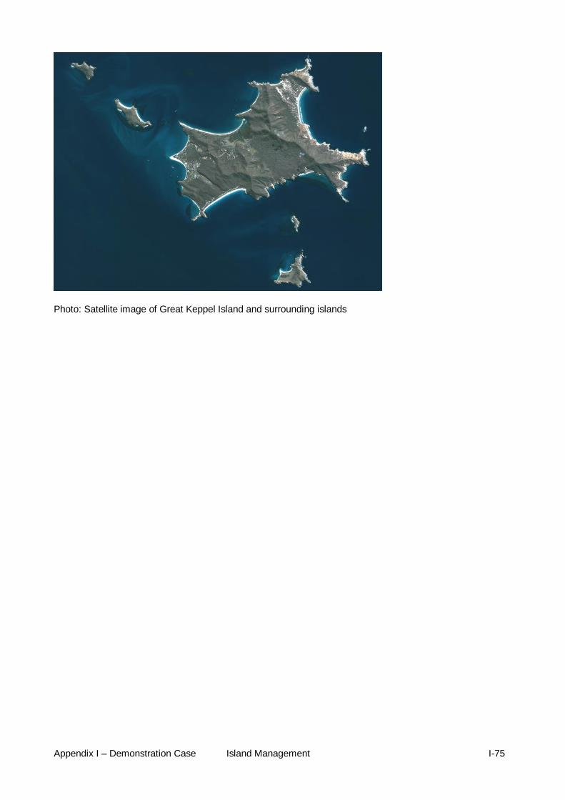
Appendix I – Demonstration Case Island Management I-75
Photo: Satellite image of Great Keppel Island and surrounding islands

Appendix I – Demonstration Case Island Management I-76
APPENDIX 9 LADY ELLIOT ISLAND
Name Lady Elliot Island Type: Vegetated rubble cay.
Size: approximately 45 hectares
Location: Lady Elliot Is. is the southernmost coral cay of the GBR. The island lies 46 nautical miles (85 kilometres) north-east of Bundaberg.
Tenure: It is part of the Capricorn and Bunker Group of islands and is a Commonwealth Island owned by GBRMPA on behalf of the Commonwealth (i.e. Commonwealth Islands Zone), noting that there is no State intertidal area around a Commonwealth Islands Zone. There is a lease with AMSA for the new aid to navigation. The current resort lease commenced in 2005. There is a Native Title claim which takes in Lady Elliot Island. The island is managed jointly by the GBRMPA and QPWS.
Matters of national environmental significance
GBRWHA
Key biodiversity values:
One of few large vegetated rubble cays in the GBRWHA. Lady Elliot Island is one of the most important sites in the GBRWHA for seabird nesting. The diversity of seabirds breeding is the second highest of any island on the GBR. The island is home to a number of threatened bird species; it is one of only two breeding sites on the GBR for the red tailed tropicbird ( listed as ‘vulnerable’ wildlife under the NC Act), and an important site for nesting roseate terns. As well as an important breeding site for these birds and other seabirds such as the black-naped terns, bridled tern, crested tern, wedge-tailed shearwater, black noddy and common noddy, it is a roosting site for the lesser and greater frigate bird and brown booby. It is also a site for migratory birds covered under international migratory bird treaties such as Pacific golden plover, bar-tailed godwit, and grey-tailed tattler. The Capricorn white-eye is confined to the southernmost GBR, and there is a resident breeding population on Lady Elliot Island. The island’s location as the southern-most island on the GBR provides an important site for seabirds to access food in the waters of the southern GBR and beyond (GBRMPA 2008 Lady Elliott LDHMP). Lady Elliot Island is an indicator species site and a key breeding site under the Coastal Bird Monitoring and Information Strategy (Department of National Parks, Recreation, Sport and Racing). An ephemeral swamp is present on the island. Pisonia grandis grew naturally on the island. Pisonia Forest is important as breeding habitat for black noddies and wedge-tailed shearwaters. In the Capricornia Cays, pisonia supports 75 per cent of all nesting seabirds in the GBRWHA. Pisonia grandis low closed forest is restricted to a few scattered sand cays and is defined as ‘of concern’ under the Vegetation Management Act 1999. The island is also a nesting site for vulnerable green turtles (Chelonia mydas) and endangered loggerhead turtles (Caretta caretta). The turtles that use Lady Elliot Island are an important component of the turtle populations of the southern GBR.
Cultural heritage: The locality and the surrounding area are culturally significant to the Taribelang Bunda, Bailai, Gooreng Gooreng, and Gurang Aboriginal Traditional Owner groups. All the islands offshore from Bundaberg/Gladstone are included in the Port Curtis Coral Coast Native Title Claim which has been active since 2001. At the time of writing, the senior anthropologist from the Gurang Land Council (the former representative body for these Traditional Owner groups) was

Appendix I – Demonstration Case Island Management I-77
investigating their cultural links to Lady Elliot Island and other islands in the region.
Historical heritage: The first lighthouse on Lady Elliot was built in 1866; however, it was destroyed by a cyclone six years later. The current lighthouse was built in 1873 and is a landmark feature that marks the southern end of the GBR. Lady Elliot Island lightstation was National Heritage listed under the EPBC Act in 2004 for its significance to the history of settlement along the Queensland coast and for its historical values associated with the lighthouse. It was the third navigation aid built by Queensland authorities and the first offshore within the GBR. The cultural significance of the Lady Elliot Island Lightstation is set out in the entry in the National Heritage List. The heritage listed lighthouse is not a working lighthouse.
Infrastructure development
An airstrip. Desalination plant. Sewerage Treatment Plant. Solar panel array. An aid to navigation (within AMSA lease).
Urban/island development:
The heritage listed lightstation contains the lighthouse and a cluster of associated service buildings, including a workhouse, power house, the old power house and a fuel store and drum platform, three houses, a boat shed, water tanks and a concrete loading dock. The resort area contains 24 guest units, 13 guest cabins, shade structures, five amenity blocks, generator shed, compressor shed, garden shed, tractor shed, 14 staff lodges, a staff house, administration building, walkway, departure lounge, five store sheds, a workshop, maintenance office, commercial kitchen, dining room, education centre, conference room, dive shop and laundry block.
Other human uses: From 1863 to 1873, Lady Elliot Island was cleared of vegetation and mined for guano. This almost completely destroyed the tree population and removed a metre of top soil and guano. Feral goats then prevented natural revegetative processes commencing until the removal of the goats. In 1969 businessman Don Adams agreed with the Department of Transport to build an airstrip on Lady Elliot Island in return for a lease of a portion of it for tourist recreation purposes and work began to revegetate the island with pandanus, casuarinas, other native flora and coconuts. The revegetation process has been continued by the current lessees and QPWS and the island has recovered providing habitat for many species of coastal birds. The island is accessed mainly by plane, although it is also accessed by private cruising yachts. The island provides significant opportunity for visitors to view a large diversity of coastal birds at the southernmost cay on the GBR, including options for day trips. Significant in-water tourism activities occur adjacent to island. No more than 250 guests are permitted on the island in daylight hours, no more than 150 are guests permitted on the island overnight, no more than 50 staff are permitted on the island overnight.
Impacts on the island Many of the buildings are constructed with asbestos which may become an environmental and OHS issue if buildings fall into disrepair. Some impacts on turtles and hatchlings as a result of artificial light impacts. Some impacts on seabirds due to aircraft landing and takeoff. Some likely impacts on the groundwater due to long-term irrigation using treated water.
Impacts in the surrounding marine environment
Currently it is considered that permitted in-water activities cause minimal disturbance, current method of guided reef walking causes minimal impact on reef, potential fin damage from snorkelling, some bleaching events, some damage being caused to reef from moorings. A non-statutory ‘no anchoring area’ is designated on the western side of the

Appendix I – Demonstration Case Island Management I-78
island. Anchoring is available adjacent to the ‘no anchoring area’. In addition, two important dive and snorkelling sites outside the ‘no anchoring area’ have been designated as ‘no anchoring sites’. The Anchor Bommie site and the Three Pyramids are marked by dive site markers. Site Management Arrangements are in place (see http://www.gbrmpa.gov.au/about-the-reef/heritage/lady-elliot-island-heritage-values): Permitted moorings – a trigger limit of 16 will apply to the total number of permitted moorings. When an application is received for further moorings, it will trigger a review of the site management arrangements. It is anticipated that the review could include public advertising of the application, and will involve discussions with users of the location including the Local Marine Advisory Committees and Traditional Owners. Dive site markers - a trigger limit of 15 will apply to the total number of permitted markers. When an application is received for further markers, it will trigger a review of the site management arrangements. It is anticipated that the review could include public advertising of the application, and will involve discussions with users of the location including the Local Marine Advisory Committees and Traditional Owners
Management and its effectiveness:
Lady Elliot Island is designated a Commonwealth Islands Zone and may be used or entered without permission for low impact (non-extractive) activities, photography, filming, sound recording, traditional use of marine resources, and limited educational programs. All other activities including camping and research require written permission. The waters surrounding Lady Elliot Island are designated a Marine National Park (Green) Zone. The GBRMPA has prepared a heritage management plan to protect and manage the Lady Elliot Island Lightstation's National heritage values. The Lady Elliot Island Lightstation Heritage Management Plan describes and assesses the heritage values, as well as detailing the obligations, appropriate policies and management regimes required to ensure that these heritage values are managed and protected. An Environmental Management System is embedded within the lease for the Resort, which outlines environmental practises and standards relating to, for example, pest and weeds control. Controls are also in place to minimise impacts on nesting turtles through reduced lighting. A new waste water treatment system was installed in 2012 to meet best practice standards. Lady Elliot Island EcoResort has introduced a range of environmental best-practice measures, including construction of a Hybrid Solar Power Station to reduce energy consumption and carbon emissions. GBRMPA and QPWS jointly manage Lady Elliot Island, including carrying out annual building inspections and developing General Maintenance Plans to ensure buildings are maintained, with safe removal of asbestos materials, once replaced, from the island.
Community The lessee manages visitor access to the island.
Other Lady Elliot Island Eco Resort has also achieved the highest level of ECO Certification program 'ECO Certified - Advanced Ecotourism' with Ecotourism Australia.
Monitoring, evaluating, resourcing and compliance
A lease arrangement is currently in place requiring maintenance of all structures on the island (including the heritage listed structures) and the management of natural values of the island. GBRMPA is currently responsible for maintenance of the lighthouse. It has been identified that the condition of the lighthouse has deteriorated and requires repairs.
Key issues for the next five years, and long term
Development of a vegetation restoration plan, primarily to manage vegetation communities to optimise suitable seabird nesting habitat.

Appendix I – Demonstration Case Island Management I-79
Continue to revegetate and maintain Pisonia forest to support black noddy and shearwaters breeding populations. Restrict to defined areas agreed between QPWS/GBRMPA. Maintain high diversity of seabird species breeding on island through management of vegetation and resort operations. Investigate options for enhancing nesting habitats for species historically nesting on island. Manage activity away from sensitive bird rookery areas. Restrict infrastructure and operations to current footprint where it has the potential to impact on natural values. Maintain the character of the rubble cay by preventing inappropriate modification of beach profile, for example by restricting import/removal/relocation of sand and existing materials. The private lessee is required to submit annual Audit Reports outlining their performance against Commonwealth lease requirements, including the EMS.
Key actions needed to address issues
Prepare a Lady Elliot Island Management Statement. Develop and Lady Elliot Island Vegetation Restoration Plan. Funding secured to carry out maintenance on the heritage listed lighthouse
to meet statutory obligations.
Photo: Historic lighthouse and new navigation light on Lady Elliot Island
Photo: Aerial view of Lady Elliot Island

Appendix I – Demonstration Case Island Management I-80
APPENDIX 10 MANAGEMENT ARRANGEMENTS
Table 1.13-1. Australian legislation and management tools
Legislation or policy Who administers it?
How it avoids, mitigates and/or offsets impacts on islands Mechanism
Environment Protection (Sea Dumping) Act 1981 Australian Maritime Safety Authority
Applies to all vessels in Australian waters and Australian vessels in international waters.
Framework for the protection of the environment by regulating the dumping into the sea of wastes and other matter and the dumping into the sea of certain other objects; and for related purposes.
Environment Protection and Biodiversity Conservation Act 1999 Environment Protection and Biodiversity Conservation Regulations (2000) Department of the Environment
Approval systems for actions with a significant impact on marine and terrestrial environments with national significance. Legislative role includes the listing and regulation of threatened and protected species and communities, and the preparation of recovery plans. One Tree Island Reef restricted access special management areas Internal general use zones Sea dumping permits
Regulates impacts on matters of national environmental significance and conserve Australian biodiversity.
Protection of the Sea (prevention of Pollution from Ships) Act 1993 Australian Maritime Safety Authority (AMSA)
Regulate the discharge of oil (Annex I), noxious liquid substances (Annex II), the disposal from ships of sewage (Annex IV) and garbage (Annex V) and prohibit the disposal of harmful substances carried by sea in packaged forms (Annex III).
Framework for the protection of the marine environment from ship-sourced pollution. Implements the International Convention for the Prevention of Pollution from Ships 1973 and the subsequent 1978 Protocol to the Convention (collectively MARPOL 73/78) and regulates normal operational discharges from ships.
Quarantine Act 1908 Australian Quarantine and Inspection Service
Quarantine inspections and compliance monitoring Regulation of ballast water Prevention of introduction of marine pests
Eco certification program for high standard tourism operators Independent auditor
Best practices habitat protection; waste management Improve operating standards

Appendix I – Demonstration Case Island Management I-81
Legislation or policy Who administers it?
How it avoids, mitigates and/or offsets impacts on islands Mechanism
Great Barrier Reef Marine Park Act 1975 Great Barrier Reef Marine Park Regulations 1983 GBRMPA. Day to day management is performed in conjunction with the Department of National Parks, Recreation, Sport and Racing through the Queensland Government Parks and Wildlife Service.
Zoning plans, management plans, permit assessments, conditions, site management, education and best practices Raine Island Reef, Moulter Cay Reef, MacLennan Cay Reef, are declare as a Special Management Areas and Reef Restricted Access SMAs -- exceptions to special management provision (Regulation 52, 54 and 56) Regulation 52, Part 4, also declares the areas described by reference to the Whitsundays Plan of Management 1998, One Tree Island inclusive. Regulating camping and other activities on islands in the Marine Park (Regulation 88); Regulation 95, about certain animals not to be taken onto Commonwealth Islands Commercial activities in Low Island (Regulation 73) Lady Elliot Island charges (Regulation 158) Penalties for non-compliance.
Provides a framework for the protection and management of the GBR Marine Park, through zoning, issuing of permits implementation plans of management that collectively enable management of human activities in the GBR Marine Park.
Great Barrier Reef Marine Park Zoning Plan 2003 GBRMPA
Spatial management of activities within the GBR based on protection of representative bioregions. Regulation and localisation of recreational, commercial, research and traditional uses allowed. Definition of the Commonwealth Islands Zone for the use or entry of areas of the Marine Park above mean low water on Commonwealth Islands.
An ecosystem-based management tool that protects biodiversity by the regulation of activities within the GBR Marine Park.
Native Title Act 1993 Provides for the recognition and protection of native title.
Sustainable island management on the Great Barrier Reef GBRMPA
Reduction of impacts from essential infrastructure on these islands Determine if the energy management strategies improve energy efficiency on Low Isle and Lady Elliot Island

Appendix I – Demonstration Case Island Management I-82
Legislation or policy Who administers it?
How it avoids, mitigates and/or offsets impacts on islands Mechanism
Great Barrier Reef Intergovernmental Agreement 2009 (http://www.environment.gov.au/coasts/gbr/agreement.html) Great Barrier Reef Ministerial Council
Recognises key pressures on the Reef—such as climate change impacts, catchment water quality and coastal development Maintain complementarity of relevant Australian and Queensland management arrangements, in particular: marine park legislation and associated regulations; zoning plans and plans of management; planning and development arrangements; environmental assessment and permit requirements; Continue joint action to halt and reverse the decline in quality of water entering the GBR Continue joint action to maximise the resilience of the GBR to climate change Address significant threats to the health and biodiversity of the GBR ecosystem, including pollution from the land and sea, the impacts of climate change, ecologically unsustainable fishing activities and other resource extraction activities Periodically review the condition of the GBR ecosystem and any need for further action Ensure that Indigenous traditional cultural practices continue to be recognised in the conservation and management of the GBR.
Ensures a collaborative approach between the Australian and Queensland Governments to manage the marine and land environments of the GBR Region

Appendix I – Demonstration Case Island Management I-83
Legislation or policy Who administers it?
How it avoids, mitigates and/or offsets impacts on islands Mechanism
Great Barrier Reef Marine Park Plans of Management (PoM) Cairns Area Plan of Management Hinchinbrook Plan of Management Whitsundays Plan of Management Shoalwater Bay (Dugong) Plan of Management Great Barrier Reef Ministerial GBRMPA
Plans of Management complement zoning by addressing issues specific to an area, species or community in greater detail than can be accomplished by the broader reef-wide zoning plans. POMs address various activities including tourism and other recreational activities, cultural activities, shipping, research, commercial and recreational fishing and collecting. Regulation and localization of recreational and commercial uses. Moorings and tourist facilities, defining limits for both. Management of tourists programs Defining fishing or collecting sites as part of a tourist programs Approval, refusal conditioning powers for actions POMs apply to the Commonwealth areas of the marine park, so no State islands, only Commonwealth Islands as these are part of the GBR Marine Park. However, requirements in the POMs assist to regulate access and activities on islands.
These Statutory Plans of Management are prepared for intensively used, or particularly vulnerable groups of islands and reefs, and for the protection of vulnerable species or ecological communities. The aim is to protect and conserve identified values of these groups, while allowing for reasonable opportunities to access and use these Planning. Areas, to provide for the long-term sustainable use of these areas.
Lady Elliot Island Lightstation Heritage Management Plan 2012 GBRMPA
The Heritage Management Plan was prepared to protect and manage the Lady Elliot Island Lightstation's National heritage values. Lady Elliot Island Lightstation was listed on the National Heritage List in 2004. EPBC Act requires an Australian Government agency that owns or controls the Australian Government heritage place to make a written plan to protect and manage the National heritage values of the place.
The Lady Elliot Island Lightstation Heritage Management Plan describes and assesses the heritage values, as well as detailing those obligations, appropriate policies and management regimes required to ensure that these heritage values are managed and protected.

Appendix I – Demonstration Case Island Management I-84
Legislation or policy Who administers it?
How it avoids, mitigates and/or offsets impacts on islands Mechanism
Site Management Arrangements GBRMPA
Site planning is to provide for a balance of recreational and commercial access consistent with the protection of conservation, scientific and cultural values. Site Management Arrangements assist to regulate access and activities on islands. Site Plan Lizard Island Locality 2, Site Plan Lizard Island Locality 3, MIchelmas Cay Locality Site Management Arrangements, Green Island Reef Locality 1 Site Plan, Frankland Islands (Normanby, Russell and Round), Low Isles, offshore from Port Douglas, Bauer Bay Site Management Arrangements, Blue Pearl Bay, Hayman Island, Cow and Calf Islands Site Plan, Deloraine Island Site Plan, Double Bay (East) Site Plan, Eshelby Islands Site Plan, Haslewood and Lupton Islands Site Plan, Fitzroy Reef Site Management Arrangements, Keppel Bay and Islands Site Management Arrangements, Lady Elliot Island and Reef, Lady Musgrave Island Reef
Issues may arise at certain sites that require further management direction or explanation. Examples include multiple permit applications for moorings, conflicts between user groups, species and/or habitat conservation, changes in use patterns – Site Plans
Navigation Act 2012 AMSA

Appendix I – Demonstration Case Island Management I-85
Table 1.13-2 Queensland legislation and management tools
Legislation or policy Who administers it?
How it avoids, mitigates and/or offsets impacts on islands Mechanism
Marine Parks (Great Barrier Reef Coast) Zoning Plan 2004 Department of National Parks, Recreation, Sport and Racing through the Queensland Parks and Wildlife Service.
Complementary to GBR Marine Park Zoning Plan 2003 – some Queensland-specific provisions apply. A comprehensive and balanced zoning system providing protection of the GBR's unique biodiversity, while continuing to provide opportunities for the use of and access to the GBR coast Marine Park.
An ecosystem-based management tool that protects biodiversity by the regulation of activities within the GBR Coast Marine Park.
Coastal Protection and Management Act 1995 Department of Environment and Heritage Protection
Provides for development of a Queensland Coastal Plan with specific policies for coastal management issues. Designation of areas of high ecological significance managing coastal use, development and nature conservation. A planning framework can provide protection for seagrass by recognising areas of seagrass as protected, as marine coastal wetlands, or as areas of high ecological significance, or have desired outcomes for environmental objectives including indirectly by managing runoff and river flows. Standards for wastewater discharge
(a) Provide for the protection, conservation, rehabilitation and management of the GBR coastal zone, including its resources and biological diversity. (b) Have regard to the goal, core objectives and guiding principles of the National Strategy for Ecologically Sustainable Development in the use of the GBR coastal zone. (c) Ensure decisions about land use and development safeguard life and property from the threat of coastal hazards. (d) Encourage the enhancement of knowledge of coastal resources and the effect of human activities on the GBR coastal zone.
Coastal Protection and Management Act 1995 (QLD) Coastal Protection and Management Regulation 2003 Department of Environment and Heritage Protection
Designation of areas of high ecological significance Managing coastal use, development and nature conservation: Managing areas of State significant wetlands Standards for wastewater discharge Specification for the design, construction and safety of boat ramps and slip ways for private purpose ,bridges, jetties and piers, pipelines underground services, retaining walls, revetments, seawalls, and wharves
Provide for the protection, conservation, rehabilitation and management of the GBR coastal zone, including its resources and biological diversity; and also for the development of the State and regional planning and integrated approval processes in relation to coast development.

Appendix I – Demonstration Case Island Management I-86
Legislation or policy Who administers it?
How it avoids, mitigates and/or offsets impacts on islands Mechanism
Environmental Protection Act 1994 Department of Environment and Heritage Protection
Environmental protection policies. Defines environment, environmental value and levels of environmental harm. Dictates a system for environmental evaluations and audits. Defines environmentally relevant activities (ERA's) comprising development. Environmental Management Programs (EMPs) GBR protection measures by reducing impact on water quality due to agricultural activities. Legal procedures for offences to water contamination. Public reporting of information on the environment Penalties for non-compliance
Environmental protection within the context of ecologically sustainable development
Fisheries Act 1994 Department of Agriculture Fisheries and Forestry and Department of National Parks Recreation Sport and Racing (for declared Fish Habitat Areas) Coastal local governments and port managers are entering into partnerships with the Queensland Government to manage protected marine plants in their areas. Fish habitat management strategies are developed jointly and enable long-term management under a self-assessable code.
Provides for declaration of Fish Habitat Areas and their protection and that of fish habitats more broadly from physical disturbance associated with coastal development. Notification and permit requirements for marine plant removal. Fish Habitat Management Operational Policies Regional plans. Dugong Protection Areas Penalties for non-compliance
All marine plants are protected under Queensland Government law through provisions of the Fisheries Act 1994. The destruction, damage or disturbance of marine plants without prior approval is prohibited.

Appendix I – Demonstration Case Island Management I-87
Legislation or policy Who administers it?
How it avoids, mitigates and/or offsets impacts on islands Mechanism
Land Act 1994 Department of Natural Resources and Mines
leases for large tourism complexes and other land uses over Queensland islands Define types of State leases Defines roads and types
Framework for the allocation of State land as leasehold, freehold or other tenure.
Marine Parks Act 2004 Marine Parks Regulations 2006 Department of National Parks, Recreation, Sport and Racing through Queensland Parks and Wildlife Service.
The Marine Parks Act 2004 includes provisions for the establishment of the GBR Marine Park, zoning, management plans, offence provisions, monitoring and enforcement and restricted area declarations. The Marine Parks Regulations 2006 provide for permissions to enter or use the GBR Marine Park (permits), commercial activity agreements, accreditation, regulatory notices and declarations, provisions for entering and using the marine park, reviews and fees.
Provides complementary zoning for the GBR Coast Marine Park. Provides a framework for the protection and management of the GBR Marine Park, through zoning, issuing of permits, plans of management that collectively enable management of human activities in the GBR Marine Park.
Marine Parks (Great Barrier Reef Coast) Zoning Plan 2004 Department of National Parks, Recreation, Sport and Racing through the Queensland Parks and Wildlife Service.
Complementary to GBR Marine Park Zoning Plan 2003 – some Queensland-specific provisions apply. A comprehensive and balanced zoning system providing protection of the GBR's unique biodiversity, while continuing to provide opportunities for the use of and access to the GBR Marine Park.
An ecosystem-based management tool that protects biodiversity by the regulation of activities within the GBR Marine Park.
Nature Conservation Act 1992 Department of National Parks, Recreation, Sport and Racing and Department of Environment and Heritage Protection
Lists the names, former descriptions, and current descriptions of the Queensland's islands declared as protected areas.
Framework for the identification, gazettal and management of protected areas and species. Protection of cultural heritage places in national parks.

Appendix I – Demonstration Case Island Management I-88
Legislation or policy Who administers it?
How it avoids, mitigates and/or offsets impacts on islands Mechanism
Cape York Peninsula Heritage Act 2007
Several islands within the GBRWHA are protected in this class of protected area.
Under the Act, amendments to the Nature Conservation Act 1992 (NC Act) allow for the creation of a new class of protected area called ‘national park (Cape York Peninsula Aboriginal land)’ (national park [CYPAL]). This new class allows for existing and proposed national parks to become Aboriginal land and also be dedicated and managed as a national park (CYPAL). It allows for joint management of national park land by Traditional Owners (represented by a land trust) and the department. Traditional Owners will be the owners of the land through the grant of an Aboriginal freehold title, provided the area will always be managed as a national park (CYPAL) under the NC Act.
Cultural Record (landscapes) Queensland and Queensland Estate Act 1987
Protection of Aboriginal cultural heritage sites and places.
Queensland Heritage Act 1992 Protection of sites and places of cultural heritage significance, which are not significant solely through association with Aboriginal tradition.
Land Protection (Pest and Stock Route Management) Act 2002 Land Protection (Pest and Stock Route Management) Regulation 2003. Department of Natural Resources and Mines
• establishing the principles of pest management for land • providing pest management planning through the development of pest management strategies and pest management guidelines • declaring animals and plants to be declared pests • restricting the introduction, keeping or sale of declared pests • preventing the spread of declared pests in the State, including, for example, preventing their spread by human activity • establishing responsibilities for pest management • establishing the Land Protection Council to give advice and make recommendations to the minister about managing pests • providing for the establishment of pest operational boards • monitoring, surveying and controlling pests
The Act provides for pest management in Queensland

Appendix I – Demonstration Case Island Management I-89
Legislation or policy Who administers it?
How it avoids, mitigates and/or offsets impacts on islands Mechanism
Fire and Pest Management policies Department of National Parks, Recreation, Sport and Racing through the Queensland Parks and Wildlife Service
Protection of natural and cultural values of island National Parks in the GBRWHA
Framework to guide fire and pest management activities across the protected area estate.
Queensland Government Coastal Plan 2012 http://www.ehp.qld.gov.au/coastalplan/ Department of Environment and Heritage Protection
The State Policy for Coastal Management component of the Coastal Plan provides policy direction for natural resource management decision-makers about land on the coast, such as coastal reserves, beaches, esplanades and tidal areas. A Draft Coastal Protection State Planning Regulatory Provision came into effect on 8 October 2012 and suspends the operation of the State Planning Policy 3/11: Coastal Protection (Coastal SPP) component of the Coastal Plan.
It provides direction and guidance about the management of coastal land in Queensland to achieve the objectives of the Coastal Act.

Appendix I – Demonstration Case Island Management I-90
Legislation or policy Who administers it?
How it avoids, mitigates and/or offsets impacts on islands Mechanism
Queensland Government Coastal Plan 2012 (State Policy for Coastal Management) Department of Environment and Heritage Protection
Determinate priority areas for: Preparation of shoreline erosion in Curtis Island, Heron Island, Green Island and Wild Cattle Island Undeveloped roads or esplanades: Hummocky Island, Facing Island, Wild Cattle Island/Colosseum Inlet, Curtis Island, Dunk Island, Hinchinbrook Island, Double Island, Haycock Island For managing the adverse impacts from public access on coastal resources: Curtis Island, Facing Island, Wild Cattle Island, and from the Capricorn Group: Tryon Island Masthead Island, Erskine Island and North West Island Importance in protecting coastal resources and their values: Curtis Island (North and East) Curtis Island (Western), Harbour islands, Facing Island, Wild Cattle, Island/Colosseum Inlet, Eva Island, Double Island and Haycock Island. Coastal management planning: Seaward side of Curtis Island and Facing Island, mainland foreshore between Boyne Island and Colosseum Inlet. Regional Coastal Management Plans of Curtis Coast, Cardwell-Hinchinbrook, Mackay-Whitsunday and Wet Tropics Coast. Implements State Coastal Management Plan's policy framework at regional level Define locations where specific management actions are required included the coastal islands
Provides direction and guidance about the management of coastal land in Queensland to achieve the objectives of the Coastal Act
Recreation Areas Management Act 2006 Department of National Parks, Recreation, Sport and Racing QPWS on behalf of the Queensland Recreational Areas Management Board
Nature-based recreation is planned and managed to protect Green island.
Framework to manage declared recreation areas, like Green Island

Appendix I – Demonstration Case Island Management I-91
Legislation or policy Who administers it?
How it avoids, mitigates and/or offsets impacts on islands Mechanism
Sustainable Planning Act 2009 (Qld). Sustainable Planning Regulation 2009 (Qld) Department of State Development, Infrastructure and Planning
The purpose of the Sustainable Planning Act 2009 is to seek to achieve ecological sustainability by—
(a) managing the process by which development takes place, including ensuring the process is accountable, effective and efficient and delivers sustainable outcomes; and
(b) managing the effects of development on the environment, including managing the use of premises; and
(c) continuing the coordination and integration of planning at the local, regional and State levels.
Establishes processes and requirements for land use planning and development assessment, including:
the making and amending of State and local planning instruments
development assessment by State or local government through the Integrated Development Assessment System (IDAS)
licensing and conditions penalties for non-compliance
Provides the framework for planning and development in Queensland State planning instruments include:
State planning regulatory provisions regional plans State planning policies standard planning scheme provisions
Local planning instruments include: a planning scheme a temporary local planning instrument a planning scheme policy
State planning policies of particular relevance include: (a) SPP 4/11 – Protection of wetlands of high ecological
significance in the GBR catchment (b) Temporary SPP 2/11 – Planning for a stronger, more
resilient floodplain (c) SPP 5/10 – Air, noise and hazardous materials (d) SPP 4/10 – Healthy Waters (e) SPP 1/03 – Mitigating the adverse impacts of flood,
bushfire and landslide (f) SPP 2/02 – Planning and managing development
involving acid sulphate soils
The Whitsunday and Mackay Islands Visitor Management Strategy 2007 Department of National Parks, Recreation, Sport and Racing through the Queensland Parks and Wildlife Service
This Strategy provides the framework and guidelines for managing visitors to national park islands in the Whitsunday and Mackay area. It sets out the considerations, outcomes and strategies that will form the basis on which day-to-day management decisions will be made. Particular emphasis is placed upon integrated planning and policies across islands, beaches and the surrounding GBR Marine Park.

Appendix I – Demonstration Case Island Management I-92
Legislation or policy Who administers it?
How it avoids, mitigates and/or offsets impacts on islands Mechanism
Queensland Government Eco and Sustainable Tourism Policy Department of National Parks, Recreation, Sport and Racing through the Queensland Parks and Wildlife Service
This policy will be implemented in stages, with the Whitsunday Islands one of the first areas identified, due to high visitor use.
Policy to improve access and provide new opportunities in national parks and other protected areas for ecotourism operators
Vegetation Management Act 1999 Department of Natural Resources and Mines
The legislation aims to ensure: conservation of biodiversity maintenance of ecological processes clearing does not cause land degradation management of the environmental effects of clearing reduction of greenhouse gases balanced decision-making support for regional communities
Designed to manage broad scale vegetation clearing, one of the key activities responsible for water quality decline
Water Act 2000 Department of Natural Resources and Mines
Water resource planning Regulates wastewater management in sewered areas
Management for environmental flow and water quality
Wild Rivers Act 2005 Wild Rivers and Other Legislation Amendment Act 2007 http://www.DNPRSR.qld.gov.au/wildrivers/hinchinbrook_island.html http://www.DNPRSR.qld.gov.au/factsheets/pdf/water/wr04.pdf Department of Environment and Heritage Protection
Helps to ensure that sustainable future development occurs without impacting on the natural values of the major rivers by providing for the regulation of particular activities and taking of natural resources in a wild river and its catchment to preserve the wild river’s natural values; having a precautionary approach to minimise adverse effects treating a wild river and its catchment as a single entity, linking the condition of the river to the health of the catchment considering the effect of individual activities and taking of natural resources on a wild river’s natural values considering the cumulative effect of activities and taking of natural resources affecting a wild river area when further activities or taking are proposed
Provides protection to undeveloped river systems in Queensland. Hinchinbrook Island has been declared as a Wild River Area.

Appendix I – Demonstration Case Island Management I-93
Legislation or policy Who administers it?
How it avoids, mitigates and/or offsets impacts on islands Mechanism
Queensland Government Heritage Act 1992 Department of Environment and Heritage Protection
Provides for the conservation of Queensland’s cultural heritage for the benefit of the community and future generations.
Indigenous Land Use Agreements Various government departments
Many islands in the GBRWHA are covered by Indigenous Land Use Agreements.
The Australian Government Native Title Act 1993 provides for Indigenous land use agreements (ILUAs) between native title holders or claimants and other interested parties about how land and waters in the area covered by the agreement will be used and managed in the future.

Appendix I – Demonstration Case Island Management I-94
Table 1.13-3. International conventions and management tools
Legislation or policy Who administers it?
How it avoids, mitigates and/or offsets impacts on islands Mechanism
Convention on the prevention of Marine Pollution by Dumping of Wastes and Other Matter (1972 and 1996) International Maritime Organisation (IMO)
Defines dumping Restricts all dumping except for a permitted list
Limits the discharge of wastes generated on land and disposed at sea
International Convention for the Prevention of Pollution from Ships (1973/1978) International Maritime Organisation (IMO)
Covers prevention of pollution by oil from operational measures as well as from accidental discharges. Mandatory for new oil tankers to have double hulls and brought in a phase-in schedule for existing tankers to fit double hulls. contains requirements to control pollution of the sea by sewage complete ban imposed on the dumping into the sea of all forms of plastic
Regulates pollution of the marine environment by ships from operational or accidental causes
UN framework Convention on Climate Change (1992) Convention Secretariat
Recognise the possible adverse effects of sea level rise on islands International framework for regulating human-influences climate change. Australia has to take climate change into account and cooperate in avoiding dangerous climate change.
World Heritage Convention United Nations Educational, Scientific and Cultural Organization (UNESCO)
Provides State Parties to the Convention with definitions of natural and cultural heritage, measures for the protection of natural and cultural heritage; the means of administration and obligations of the Convention; funding arrangements, educational programs and reporting obligations.
Identification, protection and preservation of cultural and natural heritage considered to be outstanding universal value. Includes the GBR as one of these values.