irc193 duhamel creek hydrogeomorphic risk assessment · duhamel creek channel and slide assessment...
TRANSCRIPT

Duhamel Creek Hydrogeomorphic Assessment
January 26, 2015
Duhamel Creek Hydrogeomorphic Risk Assessment
By: Kim Green, P.Geo., PhD Apex Geoscience Consultants Ltd
Nelson, BC. www.apexgeoconsultants.com
APEX FILE HA-14-KL-01
January 2015
Duhamel Creek at beaver-dam wetland complex (Site 14-12)
Prepared for: Tyler Hodgkinson, RPF Woodlands Manager
Kalesnikoff Lumber Co. Ltd. Thrums, B.C.

i Duhamel Creek Hydrogeomorphic Assessment
January 26, 2015
Contents List of Tables ......................................................................................................................................... ii
List of Figures ............................................................................................................................ ii
List of Photographs ................................................................................................................... iii
1.Introduction ...........................................................................................................................1
2.Background ............................................................................................................................1
Consumptive water use .............................................................................................................2
Development history .................................................................................................................3
3.Physical characteristics of Duhamel Creek watershed .............................................................4
Physiography (in part from Apex, 2004).....................................................................................4
Reach Descriptions ....................................................................................................................5
Aspect Distribution....................................................................................................................6
Flood frequency analysis ...........................................................................................................8
Causes of flooding .....................................................................................................................8
4.Observations ..........................................................................................................................9
Reach 6 – Headwater (Six-Mile) lakes ...................................................................................... 11
Reach 5 – Upper semi-alluvial reach ........................................................................................ 13
Reach 4 – Bedrock confined reach ........................................................................................... 15
Reach 3 Alluvial reach ............................................................................................................. 15
Reach 2 Debris flood reach ...................................................................................................... 16
Reach 1 Alluvial fan ................................................................................................................. 20
Tributary 1 . ............................................................................................................................ 21
5.Hydraulic geometry and grain size analysis ........................................................................... 23
6.Risk Analysis ......................................................................................................................... 26
Definition of Element at Risk ................................................................................................... 27
Definition of Hazardous events in Duhamel Creek ................................................................... 27
Processes of Debris floods in Tributary 1 and Reach 2 .............................................................. 27
Floods capable of substantially increasing sedimentation at the intake ................................... 28
Assessment of Consequence ................................................................................................... 29
Risk Assessment ...................................................................................................................... 29
The influence of forest harvesting on frequency of debris floods in Tributary 1. ........................ 29
The influence of forest harvesting on the frequency of sediment mobilizing floods ................... 30
7.Summary and Recommendations for Forest Management ................................................... 32
Sediment Delivery ................................................................................................................... 32
Peak flows and channel forming floods.................................................................................... 33
Riparian function ..................................................................................................................... 33
Recommendations .................................................................................................................. 34

ii Duhamel Creek Hydrogeomorphic Assessment
January 26, 2015
Level of Harvest and harvest distribution ................................................................................. 34
Harvesting on active debris flow and snow avalanche fans/cones............................................ 35
Road construction and deactivation ........................................................................................ 36
Riparian Management to maintain ecosystem function ........................................................... 36
8.Closure and Limitations ........................................................................................................ 37
9.Literature Cited .................................................................................................................... 38
Appendix 1 Water License information .................................................................................... 39
Appendix 2. Background literature for new hydrological recovery curve.................................. 50
Appendix 3 - Climate Change, Flood Frequency in Duhamel Creek and implications for Forest Harvesting. . ............................................................................................................................ 57
Appendix 4. Field notes from field survey ................................................................................ 60
List of Tables
Table 1. Forest Development/disturbance to 2014 ...................................................................... 4
Table 2. Quantitative and qualitative frequency definitions for a hazard adapted from LMH 61. 26
Table 3. Example consequence assignment. .............................................................................. 26
Table 4. A qualitative risk matrix adapted from Wise et al., 2004. .............................................. 26
List of Figures
Figure 1. Points of diversion for domestic water licenses in Duhamel Creek. ............................... 2
Figure 2. Existing (green) and proposed (CP53, pink) blocks in the Duhamel watershed. .............. 3
Figure 3. Google Earth image looking upstream at Reach 3 of Duhamel Creek showing wetland segments (green) above colluvial cones (pink) ............................................................................. 6
Figure 4. Channel profile with reach breaks (green).. ................................................................... 6
Figure 5. Aspect distribution of Duhamel Creek. .......................................................................... 7
Figure 6. June 1st 8:00am east side in shade, 5:30pm west side in shade ..................................... 7
Figure 7. Flood frequency curve.. ................................................................................................ 8
Figure 8. Relationships between temperature preciptiation and discharge in Duhamel Creek. .... 9
Figure 9. Watershed map showing field survey locations from 2013 (13-#)and 2014. ................ 10
Figure 10. Hydraulic geometry of Duhamel Creek ...................................................................... 24
Figure 11. Channel bed grain size distribution along Duhamel Creek.. ....................................... 25
Figure 12. Google Earth image of Tributary 1 ............................................................................. 27
Figure 13. Duhamel hypsometric curve. .................................................................................... 32
Figure 14. Hypothetical change in frequency if harvesting of 19% of the watershed area is concentrated on a single aspect slope.. ..................................................................................... 35

iii Duhamel Creek Hydrogeomorphic Assessment
January 26, 2015
List of Photographs Photo 1. Duhamel wetlands in Reach 6...................................................................................... 11
Photo 2. Confined channel segment of Reach 6. Mobile bedload is primarily gravel and sand. Larger angular colluvium in channel is mossy and appears immobile. ........................................ 12
Photo 3. Duhamel Creek looking upstream (A) and downstream (B) in vicinity of survey site 14-14. ............................................................................................................................................ 13
Photo 4. Tributary at Station 14-13 with small cobble and finer bedload is typical of natural sources of sediment to Duhamel annually. ................................................................................ 14
Photo 5. Woody debris jam comprised of old woody debris, some have cut ends. Survey Site 14-16. ............................................................................................................................................ 14
Photo 6. Sites 13-019 (below) and 13-021 (above) display the transition from wetland to step-pool morphology above colluvial cone confined valley bottom. Bedload consists of a very large volume of sand and gravel stored in these low gradient channel segments. .............................. 15
Photo 7. Looking upstream at 13-001. ....................................................................................... 17
Photo 8. (A) Old LWD jam at Survey site 13-009. light coloured bed is fine sand and gravel stored upstream of the dam. Below: (B) looking downstream towards jam. Jam is roughly 3 meters high on the downstream side. ........................................................................................................... 18
Photo 9. Photo taken at the same location on Duhamel Creek in 2003 and 2014 provides evidence that there has been no large channel forming flood in Duhamel Creek in the past 10 years. ........................................................................................................................................ 19
Photo 10. Looking downstream at 40 to 50 year old log crib wall along eastern bank that was built to contain Duhamel Creek during flood events. Additional material has been added to the top of this crib wall in the past few years................................................................................... 20
Photo 11. Looking upstream near apex of Duhamel fan at old channel of Duhamel Creek that was abandoned during the last large flood (1983?) ................................................................... 21
Photo 12. Looking downstream at vegetated boulder deposit from last large debris flood. Age is estimated at between 20 and 30 years on the basis of vegetation. ............................................ 22
Photo 13. Looking downsream (left) and upstream (right) on Tributary 1 at the mid elevations. Survey site is located just at the bottom end of a large recent (2012) snow avalanch deposit of broken LWD. ............................................................................................................................. 22
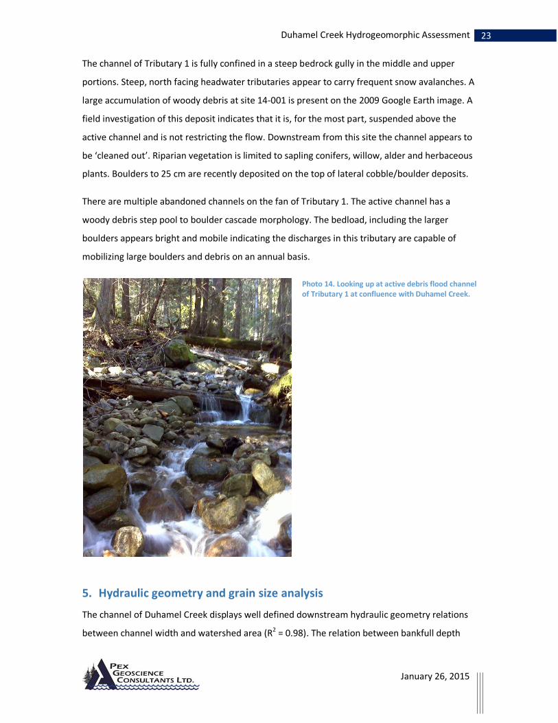
Photo 14. Looking up at active debris flood channel of Tributary 1 at confluence with Duhamel Creek. ....................................................................................................................................... 23
Photo 15. Typical wetland segment with sand, gravel and small cobble bed. ............................. 29

1 Duhamel Creek Hydrogeomorphic Assessment
January 26, 2015
1. Introduction
Mr. Tyler Hodgkinson R.P.F., Woodlands Manager for Kalesnikoff Lumber Co. Ltd., Thrums, BC,
requested that Kim Green P.Geo., PhD of Apex Geoscience Consultants Ltd. (Apex) Undertake a
hydrogeomorphic assessment of the Duhamel watershed to provide guidance for forest
management. Duhamel Creek is designated as a community watershed for the Six-Mile Water
Users Association. The objectives set by government for water in community watersheds (From;
Forest and Range Practices Act: FOREST PLANNING AND PRACTICES REGULATION B.C. Reg.
14/2004, O.C. 17/2004) state that forest activities must not cause cumulative hydrological
effects that result in a material adverse impact on the quantity of water or the timing of the flow
of the water to the waterworks, or a material adverse impact on human health (i.e., water
quality) that cannot be addressed by water treatment.
This report is intended to assess the likelihood of adverse material impacts to water quality and
quantity of flows at the intake associated with harvesting in the Duhamel Creek Watershed. The
report includes an analysis of the forestry related changes in flood frequency that could
negatively impact water quality and quantity at the intake on the fan of Duhamel Creek. The risk
assessment procedure outlined in B.C. MFLNR Land Management Handbook 61 Managing
Forested Watersheds for Hydrogeomorphic Risk on Fans provides the framework for the analysis
presented in this report.
2. Background
Past Studies
Previous watershed level studies undertaken in Duhamel Creek include:
Duhamel Creek Channel and Slide Assessment October 2013 Summary of Findings (Apex
2013)
Duhamel Creek Hydro-geomorphological Assessment (Apex, 2004)
Duhamel Creek IWAP (Deverney, 1999),
Water quality and quantity reports for Duhamel Creek (Cybele Consulting, 1999,
Westcott, 1999, 2000, 2001),
Terrain and terrain stability mapping (Wehr and Salway, 1995)

2 Duhamel Creek Hydrogeomorphic Assessment
January 26, 2015
In addition to these watershed level studies there have been several site level terrain stability
studies done as part of specific development permits over the past decade. DTSFA reports
prepared by Apex have been reviewed prior to or as part of this study but are not listed here.
Consumptive water use
Figure 1. Points of diversion for domestic water licenses in Duhamel Creek (Downloaded from imapbc, Sept 2014).
As of September 2014 there are 151 registered active water licenses in Duhamel Creek
(Appendix 1). Of these, 92 licenses are registered as domestic use and 3 are registered as water
works. Figure 1 shows the points of diversion (POD) for the active (green dots) domestic water
licenses in Duhamel Creek.

3 Duhamel Creek Hydrogeomorphic Assessment
January 26, 2015
Development history
Figure 2. Existing (green) and proposed (pink) blocks as well as recently burnt areas (brown) in the Duhamel watershed. Note, proposed harvesting was formerly designated as CP 46 as shown in legend but has been changed to CP 53.
Duhamel Creek has experienced a long history of logging activities. In the early 1900’s much of
the riparian area and lower slopes of Duhamel Creek in the vicinity of Six-Mile Lakes were
logged. During this earliest logging, logs were transported down Duhamel Creek by log-drives
(https://upthelakehistory.wordpress.com/). The forest stand has, for the most part recovered
from this earliest logging although much of the old cut wood currently in Duhamel Creek likely
entered the channel during the early 1900’s log driving or riparian logging activities. The earliest
logging activities in Duhamel Creek recorded in the forest inventory (VRI) database occurred in
4 Duhamel Creek Hydrogeomorphic Assessment
January 26, 2015
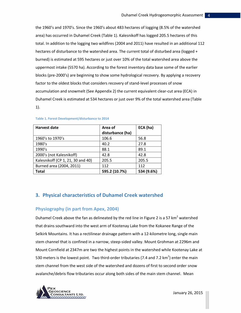
the 1960’s and 1970’s. Since the 1960’s about 483 hectares of logging (8.5% of the watershed
area) has occurred in Duhamel Creek (Table 1). Kalesnikoff has logged 205.5 hectares of this
total. In addition to the logging two wildfires (2004 and 2011) have resulted in an additional 112
hectares of disturbance to the watershed area. The current total of disturbed area (logged +
burned) is estimated at 595 hectares or just over 10% of the total watershed area above the
uppermost intake (5570 ha). According to the forest inventory data base some of the earlier
blocks (pre-2000’s) are beginning to show some hydrological recovery. By applying a recovery
factor to the oldest blocks that considers recovery of stand-level processes of snow
accumulation and snowmelt (See Appendix 2) the current equivalent clear-cut area (ECA) in
Duhamel Creek is estimated at 534 hectares or just over 9% of the total watershed area (Table
1).
Table 1. Forest Development/disturbance to 2014
Harvest date Area of disturbance (ha)
ECA (ha)
1960’s to 1970’s 106.6 56.8
1980’s 40.2 27.8
1990’s 88.1 89.1
2000’s (not Kalesnikoff) 42.8 42.8
Kalesnikoff (CP 1, 21, 30 and 40) 205.5 205.5
Burned area (2004, 2011) 112 112
Total 595.2 (10.7%) 534 (9.6%)
3. Physical characteristics of Duhamel Creek watershed
Physiography (in part from Apex, 2004)
Duhamel Creek above the fan as delineated by the red line in Figure 2 is a 57 km2 watershed
that drains southward into the west arm of Kootenay Lake from the Kokanee Range of the
Selkirk Mountains. It has a rectilinear drainage pattern with a 12-kilometre long, single main
stem channel that is confined in a narrow, steep-sided valley. Mount Grohman at 2296m and
Mount Cornfield at 2347m are two the highest points in the watershed while Kootenay Lake at
530 meters is the lowest point. Two third-order tributaries (7.4 and 7.2 km2) enter the main
stem channel from the west side of the watershed and dozens of first to second order snow
avalanche/debris flow tributaries occur along both sides of the main stem channel. Mean

5 Duhamel Creek Hydrogeomorphic Assessment
January 26, 2015
annual precipitation ranges from 800 at lower elevations up to 2200 mm annually along upper
elevation slopes.
Most of Duhamel Creek is underlain by coarsely crystalline granodioritic rocks of the Nelson
Batholith. The linear nature of Duhamel Creek suggests that bedrock structures such as faults
are controlling drainage patterns. Surficial geology includes veneers of sandy, blocky colluvium
along the upper and mid-elevation steep valley side slopes, blankets and veneers of sandy to
silty (locally clay) slightly compact till on the mid and lower elevation side-slopes, and remnant
sandy glaciofluvial (kame) terraces along the lower valley slopes in the lower half of the
watershed.
Reach Descriptions
Duhamel Creek comprises six morphologically distinct reaches (Figure 2). These reaches, which
display different channel gradients, confinement and morphology differ from reaches defined in
an earlier watershed assessment (Deverney, 1999). Reach 6, the uppermost reach is
characterized by a broad, low gradient, U-shaped valley that contains the Six-Mile Lakes and
beaver dam controlled wetlands. Reach 5 is a relatively steep gradient, confined, semi-alluvial
segment with many snow avalanche/debris flow tributaries that supply large angular colluvium
and woody debris to the main stem channel. Many of these cones/fans constrict the valley
bottom of Duhamel Creek creating low gradient areas on the upstream sides and steep cascade
channel segments along the cone deposit and for a distance downstream. Reach 4 is a steep,
bedrock confined reach that contains large angular colluvial blocks and bedrock. Reach 3 is
similar to Reach 5 in that it has multiple debris/avalanche cones impinging on the valley bottom
creating lower gradient areas upstream and steeper gradient cascade segments downstream. In
this reach low gradient wetland areas are present on the upstream side of the colluvial cones
(Figure 3).

6 Duhamel Creek Hydrogeomorphic Assessment
January 26, 2015
An example of the influence of the colluvial cones along the profile of Duhamel Creek is evident
in Figure 4. The break between Reach 2 and Reach 3 corresponds to the upstream location of
the large debris flow fan of Tributary 1 (Figure 2). The steep gradient of Reach 2 is controlled by
the slope of the outer edge of the debris flow fan. From this reach break down to the fan of
Duhamel Creek (Reach 1) a large amount of the bedload sediment is derived from debris
flows/floods from Tributary 1.
Figure 4. Channel profile with reach breaks (green). Red dot identifies intake of 6-mile water users which is the upper-most POD in Duhamel Creek.
Aspect Distribution
A GIS analysis of the watershed indicates that slope aspect is generally east-west. The two major
slope aspects are east-northeast (37.5%) and south-southwest-west (40.2%). North aspect
slopes represent 9.2% of the total area, southeast aspect represent 9% of the total area while
northwest represents 4 % respectively (Figure 5).
Figure 3. Google Earth image looking upstream at Reach 3 of Duhamel Creek showing wetland segments (green) above colluvial cones (pink)
Reach 6
Reach 4 Reach 3
Reach 2 Reach 1
fan
Reach 5

7 Duhamel Creek Hydrogeomorphic Assessment
January 26, 2015
Figure 6. June 1st 8:00am east side in shade, 5:30pm west side in shade
The steep slope gradients combined with the East-West aspect distribution in Duhamel Creek
results in shading of portions of the watershed through the day during the majority of the snow
melt period. A google earth image showing sunlight distribution for May 1st (start of spring
freshet) indicates that up until 9:00 am west aspect slopes on the east side of the watershed are
Figure 5. Aspect distribution of Duhamel Creek. Steep gradient east-west aspect slopes result in shading of either side during the spring snowmelt period during portions of the day. (See Figure 6)

8 Duhamel Creek Hydrogeomorphic Assessment
January 26, 2015
in shade and by 4:30pm east aspect slopes on the west side are in shade. By June 1st there is
approximately 1 hour of additional sunlight on both aspects (Figure 6). The shading in Duhamel
Creek results in roughly 40% less direct solar energy available to melt snow during the spring
freshet period compared to a lower gradient watershed such as Selous Creek.
Flood frequency analysis
A flood frequency analysis using the 19 year record of peak flows in Duhamel Creek (Env.
Canada station 08NJ026 downloaded July 2014 from http://wateroffice.ec.gc.ca/) yields the
cumulative frequency distribution curve shown in Figure 7. The annual maximum daily flood in
2012, which recorded an average daily discharge of 14.2 m3/s, is the largest flood on record for
the 19 year period of gauging. A flood frequency analysis using a Log Pearson III frequency
distribution suggests that a 1:200 year flood event (minimum event for design works) is likely to
reach 20 m3/s (Figure 7). A discussion on the possible impacts of climate change on the Duhamel
Creek flood frequency analysis and the implications for forest development is presented in
Appendix 3.
Figure 7. Flood frequency curve. Table on right is ranked historical frequency distribution. 2012 flood was largest flood on record with an estimated return period of greater than 1:30 yrs.
Causes of flooding
An investigation of the processes triggering large floods in Duhamel Creek such as those that
occurred in 1997 and 2012 indicates that rapid snowmelt driven solely by warm sunny weather
Rank Year DischargeExc ProbRtn Pd
1 2012 14.2 3.125 32
2 1997 13.7 8.333 12
3 2006 13.2 13.54 7.38
4 1999 12.6 18.75 5.33
5 2013 10.6 23.96 4.17
6 2011 9.93 29.17 3.43
7 2007 9.9 34.38 2.91
8 2002 9.57 39.58 2.53
9 2008 9.1 44.79 2.23
10 2009 8.83 50 2
11 1998 7.95 55.21 1.81
12 2003 7.56 60.42 1.66
13 2003 7.56 65.63 1.52
14 1995 7.29 70.83 1.41
15 2010 6.76 76.04 1.32
16 2004 6.68 81.25 1.23
17 2005 6.55 86.46 1.16
18 2000 6.4 91.67 1.09
19 2001 6.22 96.88 1.03

9 Duhamel Creek Hydrogeomorphic Assessment
January 26, 2015
(2012) and snowmelt driven by heavy spring rain-on-snow are capable of causing large flood
events (Figure 8).
Figure 8. Relationships between temperature, precipitation and discharge in Duhamel Creek reveals that the 1997 flood (top) was due entirely to warm temperatures while the 2012 flood (bottom) was associated with a rain-on-snow event.
4. Observations
The channel of Duhamel Creek was field surveyed in October 2013 and August 2014. The survey
recorded channel geometry data, information on sediment transfer processes, the size and
composition of mobile bed load, observations of riparian function and channel
disturbance/flood history. Survey information was collected along the length of Duhamel Creek
from Six-Mile Lakes to the fan and along the middle and lower reaches of Tributary 1 (Figure 9,
red dots). Due to poor access Reach 4 was not surveyed in the field.

10 Duhamel Creek Hydrogeomorphic Assessment
January 26, 2015
Figure 9. Watershed map showing field survey locations from 2013 (13-#)and 2014 (14-#) field sites, Reach breaks and POD's.
11 Duhamel Creek Hydrogeomorphic Assessment
January 26, 2015
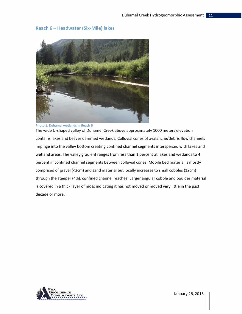
Reach 6 – Headwater (Six-Mile) lakes
Photo 1. Duhamel wetlands in Reach 6
The wide U-shaped valley of Duhamel Creek above approximately 1000 meters elevation
contains lakes and beaver dammed wetlands. Colluvial cones of avalanche/debris flow channels
impinge into the valley bottom creating confined channel segments interspersed with lakes and
wetland areas. The valley gradient ranges from less than 1 percent at lakes and wetlands to 4
percent in confined channel segments between colluvial cones. Mobile bed material is mostly
comprised of gravel (<2cm) and sand material but locally increases to small cobbles (12cm)
through the steeper (4%), confined channel reaches. Larger angular cobble and boulder material
is covered in a thick layer of moss indicating it has not moved or moved very little in the past
decade or more.
12 Duhamel Creek Hydrogeomorphic Assessment
January 26, 2015
Sediment enters this reach primarily from steep first order tributaries which transport
substantial volumes of gravel and finer material annually from headwaters down to the valley
bottom. Larger colluvium and woody debris is transported to the Duhamel channel less
frequently through debris flow/snow avalanche processes. Once this coarse textured material
reaches the Duhamel Creek channel it is limited in mobility by the low valley gradients.
Sediment coarser than about 5 cm that entered Duhamel Creek during the 1997 road-related
debris flow from Tributary 2 has moved a total of 200 meters in the past 17 years. Most of this
deposit is now vegetated with willows and alder but the channel is still aggraded with cobbles
and finer sediment.
Disturbance from early 1900’s logging is still evident along confined channel segments. There is
very little functioning woody debris in the channel through Reach 6. Mature coniferous stems
are lacking from much of the riparian area. Riparian vegetation includes willows, dogwood,
sedges and herbaceous plants along lakes and wetland areas. In confined reaches channel banks
are vegetated with grasses, herbaceous plants and deciduous shrubs. Mixed age hemlock and
cedar occur along upper banks – some is starting to fall across channel. There is still some very
old, rotten and broken woody debris along margins of channel from early 1900’s logging.
Recent accumulations of small woody debris along the channel suggest a large (overbank) flood
event occurred in the past few years. A much larger (channel forming) flood event that broke up
Photo 2. Confined channel segment of Reach 6. Mobile bedload is primarily gravel and sand. Larger angular colluvium in channel is mossy and appears immobile.

13 Duhamel Creek Hydrogeomorphic Assessment
January 26, 2015
large woody debris accumulations, deposited lateral cobble/gravel bars and locally eroded
banks in this reach appears to have occurred roughly 20 years ago or more.
Reach 5 – Upper semi-alluvial reach
Photo 3. Duhamel Creek looking upstream (A) and downstream (B) in vicinity of survey site 14-14.
Reach 5 of Duhamel Creek has a boulder cascade to step pool morphology. Cascade reaches are
due to angular colluvial boulders from avalanche cones. Channel gradient ranges from 14
percent in steeper sections to 3 percent in lower gradient sections upstream from avalanche
cones. Bed material up to 23 cm is mobile annually through steeper reaches and up to
approximately 15 cm through the lower gradient segments. Large angular colluvium in the
channel is moss covered and appears immobile. Channel bed is bimodal in appearance with
sand and gravel surrounding large colluvial boulders.
Banks are vegetated and mossy. Riparian vegetation consists of mostly willow and dogwood
along channel banks with mixed age cedar and hemlock on upper banks to 60 cm (DBH).
Sediment, mostly small cobble and finer, enters the channel through steep 1st order tributaries
on either side of the valley. Two road drainage-caused debris slides have entered Reach 5 of
Duhamel Creek in the last several years. The majority of sediment from these debris slides is
deposited along the channel margins but the channel of Duhamel Creek is locally aggraded for
A B

14 Duhamel Creek Hydrogeomorphic Assessment
January 26, 2015
approximately 50 meters downstream from the 2011 debris slide which deposited a few
hundred cubic meters of sediment on the valley flat.
Photo 4. Tributary at Station 14-13 with small cobble and finer bedload is typical of natural sources of sediment to Duhamel annually.
Much of the woody debris in this reach is very old and cut-ends suggest that it entered the
channel during old logging activities. Old LWD debris is partially functioning in jams to retain bed
sediment but most is broken and oriented parallel to channel margins.
Photo 5. Woody debris jam comprised of old woody debris, some have cut ends. Survey Site 14-16.

15 Duhamel Creek Hydrogeomorphic Assessment
January 26, 2015
Recent (2 to 3 yr) flood event has mobilized small woody debris but large woody debris jam at
site 14-16 appears to be at least 3 decades old indicating a flood capable of moving this material
has not occurred for some time.
Reach 4 – Bedrock confined reach
A steep-sided bedrock canyon extends for approximately 1 kilometer upstream from survey site
13-22. This channel reach was not surveyed due to steep terrain which limits access to this
reach. Channel gradient averages approximately 10 percent and the channel is confined on both
sides by bedrock cliffs.
Reach 3 Alluvial reach
Below the bedrock canyon the channel of Duhamel Creek is mostly alluvial so that the channel
geometry and bed characteristics are more directly controlled by the contemporary flood
regime. Channel morphology ranges from cobble-boulder cascade adjacent to colluvial cones to
step-pool morphology in transition areas to low gradient wetlands above the cones. Bed
material up to approximately 20 cm is mobile annually.
Photo 6. Sites 13-019 (below) and 13-021 (above) display the transition from wetland to step-pool morphology above colluvial cone confined valley bottom. Bedload consists of a very large volume of sand and gravel stored in these low gradient channel segments.
16 Duhamel Creek Hydrogeomorphic Assessment
January 26, 2015
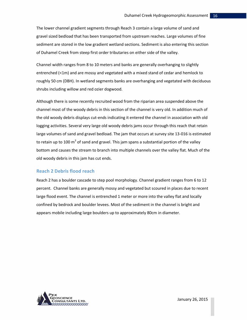
The lower channel gradient segments through Reach 3 contain a large volume of sand and
gravel sized bedload that has been transported from upstream reaches. Large volumes of fine
sediment are stored in the low gradient wetland sections. Sediment is also entering this section
of Duhamel Creek from steep first order tributaries on either side of the valley.
Channel width ranges from 8 to 10 meters and banks are generally overhanging to slightly
entrenched (<1m) and are mossy and vegetated with a mixed stand of cedar and hemlock to
roughly 50 cm (DBH). In wetland segments banks are overhanging and vegetated with deciduous
shrubs including willow and red ozier dogwood.
Although there is some recently recruited wood from the riparian area suspended above the
channel most of the woody debris in this section of the channel is very old. In addition much of
the old woody debris displays cut-ends indicating it entered the channel in association with old
logging activities. Several very large old woody debris jams occur through this reach that retain
large volumes of sand and gravel bedload. The jam that occurs at survey site 13-016 is estimated
to retain up to 100 m3 of sand and gravel. This jam spans a substantial portion of the valley
bottom and causes the stream to branch into multiple channels over the valley flat. Much of the
old woody debris in this jam has cut ends.
Reach 2 Debris flood reach
Reach 2 has a boulder cascade to step pool morphology. Channel gradient ranges from 6 to 12
percent. Channel banks are generally mossy and vegetated but scoured in places due to recent
large flood event. The channel is entrenched 1 meter or more into the valley flat and locally
confined by bedrock and boulder levees. Most of the sediment in the channel is bright and
appears mobile including large boulders up to approximately 80cm in diameter.

17 Duhamel Creek Hydrogeomorphic Assessment
January 26, 2015
Photo 7. Looking upstream at 13-001.
Woody debris is starting to enter the channel from the adjacent riparian stand but most of this
recently recruited wood is still suspended above the channel. Woody debris currently in the
channel is mostly old and many pieces are cut. There are a number of woody debris jams
comprised of old, cut and broken LWD in Reach 2. A large (mega-jam) is present at Survey Site
13-009. This jam is estimated to be storing approximately 100 to 200 m3 of fine sand and gravel.
A partial break of this jam released roughly 90 m3 of fine grained material likely during the 2012
flood event.
Disturbance indicators in the riparian area and the age of riparian vegetation indicate that the
last channel forming flood event occurred roughly 20 to 30 years ago. This event pushed woody
debris out of the channel and deposited it parallel to banks, eroded banks and deposited lateral
cobble/boulder bars that now are vegetated with mosses, grasses, shrubs and sapling hemlock.
The last very large flood that caused extensive disturbance to the riparian area and deposited a
boulder levee that is upwards of 1 meter or more higher than the bankfull channel appears to
have occurred roughly 50 years ago. This deposit has a mixed stand of birch, hemlock and cedar
established on it that are roughly 20 cm (DBH). The largest woody debris jams in this reach of
Duhamel Creek appear to have been in place since this last major flood event.

18 Duhamel Creek Hydrogeomorphic Assessment
January 26, 2015
The coarse textured morphology and relatively steep gradient of Reach 2 (compared to Reach 3)
is due to the presence of a large debris flow fan that has built up at the bottom of Tributary 1
over the past 10,000 years since deglaciation. Multiple boulder levees over the surface of this
fan and a bright, mobile channel bed attest to its frequent activity (Photo 9). The large volume
of coarse textured bedload in Duhamel Creek below the confluence with Tributary 1 has entered
the stream through debris flows/floods from this steep active tributary.
Photo 8. (A) Old LWD jam at Survey site 13-009. light coloured bed is fine sand and gravel stored upstream of the dam. Below: (B) looking downstream towards jam. Jam is roughly 3 meters high on the downstream side.
A
B

19 Duhamel Creek Hydrogeomorphic Assessment
January 26, 2015
A visual comparison of the Duhamel Creek channel at a survey site immediately up stream of
Tributary 1 confluence suggests that there has been no substantial change in channel
morphology in this location over the past 10 years (Photo 9).
Photo 9. Photo taken at the same location on Duhamel Creek in 2003 and 2014 provides evidence that there has been no large channel forming flood in Duhamel Creek in the past 10 years.
2003
2014

20 Duhamel Creek Hydrogeomorphic Assessment
January 26, 2015
Reach 1 Alluvial fan
The alluvial fan of Duhamel Creek above Highway 3a has a gradient of 6% and is constructed of
cobbles and boulders. Boulders to approximately 35 cm diameter are moving annually in this
lowest reach of Duhamel Creek. Channel banks are mossy and vegetated with shrubs but are
vertical to laid-back as a result of a 40 to 50 year old flood. Locally the channel banks show some
recent erosion and scour.
Near the apex of the fan (Site 14-23) disturbance indicators including an abandoned channel
indicate that the very large flood that occurred roughly 40 to 50 years ago caused the channel of
Duhamel Creek to shift laterally and deposited a cobble/boulder levee along the eastern bank
that is approximately 1.3 to 1.5 meters higher than the existing bank full elevation.
Log crib walls, which appear to have been built immediately after the large flood along the
channel margins, are back-filled with the cobble/boulder material in an effort to contain
Duhamel Creek in two channels during flood flows. The majority of logs in these crib walls are
now rotten and beginning to collapse (Photo 10). Additional cobble/boulder material has been
placed on top of the log crib walls in the recent past (2 years) to provide additional containment
to the channel.
Photo 10. Looking downstream at 40 to 50 year old log crib wall along eastern bank that was built to contain Duhamel Creek during flood events. Additional material has been added to the top of this crib wall in the past few years.

21 Duhamel Creek Hydrogeomorphic Assessment
January 26, 2015
Photo 11. Looking upstream near apex of Duhamel fan at old channel of Duhamel Creek that was abandoned during the last large flood (1983?)
Tributary 1
Tributary 1 has a steep (>25%) bedrock to boulder cascade morphology in the middle and upper
sections (Site 14-001) and a forced step-pool to boulder cascade morphology (14-16%) at lower
elevations in the vicinity of the Six-Mile Road. At the lower elevations above the Six Mile Road,
the channel is confined on a 10 to 15 meter wide valley flat by steep valley sides. Woody debris
jams are present in the channel and are causing the channel to shift laterally over the valley flat.
Channel banks are vertical to overhanging and vegetated with a mixed age stand of cedar and
hemlock. Recent scour of channel banks and adjacent forest floor indicates that this tributary
carried an overbank flood in the last couple of years.
Multiple boulder levees on the fan of Tributary 1 of various ages indicate that the channel of
Tributary 1 carries debris floods/flows with an apparent frequency of about 1:20 to 1:50 years.
The last debris flood event that mobilized boulder-sized sediment and woody debris appears to
have occurred roughly 20 to 30 years ago. Boulder levees from this last debris flood are moss
covered and have 3 meter high hemlock saplings established on them (Photo 12). Archived
hydrometric data for Duhamel Creek and nearby Five-Mile Creek, together with climate data for
Nelson (NelsonNE climate station), show that large flood events occurred in 1983 and 1997 and
that these floods were due to rapid snowmelt following several consecutive days of
exceptionally warm spring weather.

22 Duhamel Creek Hydrogeomorphic Assessment
January 26, 2015
Photo 12. Looking downstream at vegetated boulder deposit from last large debris flood. Age is estimated at between 20 and 30 years on the basis of vegetation.
Photo 13. Looking downstream (left) and upstream (right) on Tributary 1 at the mid elevations. Survey site is located just at the bottom end of a large recent (2012) snow avalanche deposit of broken LWD.
23 Duhamel Creek Hydrogeomorphic Assessment
January 26, 2015
The channel of Tributary 1 is fully confined in a steep bedrock gully in the middle and upper
portions. Steep, north facing headwater tributaries appear to carry frequent snow avalanches. A
large accumulation of woody debris at site 14-001 is present on the 2009 Google Earth image. A
field investigation of this deposit indicates that it is, for the most part, suspended above the
active channel and is not restricting the flow. Downstream from this site the channel appears to
be ‘cleaned out’. Riparian vegetation is limited to sapling conifers, willow, alder and herbaceous
plants. Boulders to 25 cm are recently deposited on the top of lateral cobble/boulder deposits.
There are multiple abandoned channels on the fan of Tributary 1. The active channel has a
woody debris step pool to boulder cascade morphology. The bedload, including the larger
boulders appears bright and mobile indicating the discharges in this tributary are capable of
mobilizing large boulders and debris on an annual basis.
5. Hydraulic geometry and grain size analysis
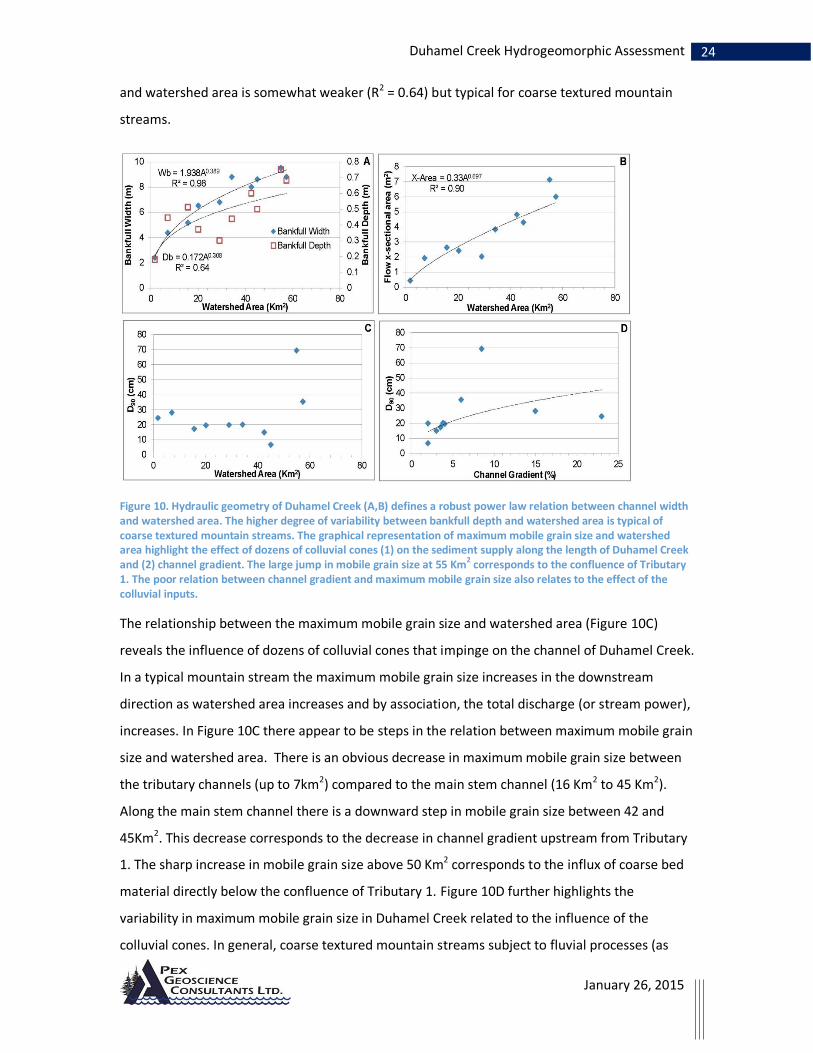
The channel of Duhamel Creek displays well defined downstream hydraulic geometry relations
between channel width and watershed area (R2 = 0.98). The relation between bankfull depth
Photo 14. Looking up at active debris flood channel of Tributary 1 at confluence with Duhamel Creek.
24 Duhamel Creek Hydrogeomorphic Assessment
January 26, 2015
and watershed area is somewhat weaker (R2 = 0.64) but typical for coarse textured mountain
streams.
Figure 10. Hydraulic geometry of Duhamel Creek (A,B) defines a robust power law relation between channel width and watershed area. The higher degree of variability between bankfull depth and watershed area is typical of coarse textured mountain streams. The graphical representation of maximum mobile grain size and watershed area highlight the effect of dozens of colluvial cones (1) on the sediment supply along the length of Duhamel Creek and (2) channel gradient. The large jump in mobile grain size at 55 Km2 corresponds to the confluence of Tributary 1. The poor relation between channel gradient and maximum mobile grain size also relates to the effect of the colluvial inputs.
The relationship between the maximum mobile grain size and watershed area (Figure 10C)
reveals the influence of dozens of colluvial cones that impinge on the channel of Duhamel Creek.
In a typical mountain stream the maximum mobile grain size increases in the downstream
direction as watershed area increases and by association, the total discharge (or stream power),
increases. In Figure 10C there appear to be steps in the relation between maximum mobile grain
size and watershed area. There is an obvious decrease in maximum mobile grain size between
the tributary channels (up to 7km2) compared to the main stem channel (16 Km2 to 45 Km2).
Along the main stem channel there is a downward step in mobile grain size between 42 and
45Km2. This decrease corresponds to the decrease in channel gradient upstream from Tributary
1. The sharp increase in mobile grain size above 50 Km2 corresponds to the influx of coarse bed
material directly below the confluence of Tributary 1. Figure 10D further highlights the
variability in maximum mobile grain size in Duhamel Creek related to the influence of the
colluvial cones. In general, coarse textured mountain streams subject to fluvial processes (as

25 Duhamel Creek Hydrogeomorphic Assessment
January 26, 2015
opposed to colluvial processes such as debris flows) display a decrease in maximum mobile grain
size with increasing channel gradient in response to increased turbulence and decreased flow
velocity. However, in Duhamel Creek Figure 10D reveals no clear trend of grain size with channel
gradient.
Despite the lack of a trend between maximum mobile grain size and watershed metrics there is
a general coarsening of the channel bed in the downstream direction (Figure 11). Grain size
distributions for 7 sites determined using the method of Wolman pebble counts are ordered
from the upstream-most site (14-03) to the most downstream site (14-21). This figure shows
that sites 14-19 and 14-21 (with curves furthest to the right) have the coarsest channel beds. It
is interesting to note that site 14-12, which is downstream from sites 14-03 and 14-07 has the
finest textured bed of all the sites. The fine textured bed at 14-12 reflects the fact that this site is
situated immediately below the beaver-dammed wetland reach directly upstream from the
confluence of Tributary 2. Sites 14-03 and 14-07 are located upstream from the wetlands and,
for this reason, have less fine grained material in their bedload.
Figure 11. Channel bed grain size distribution along Duhamel Creek. Sites are in order from upstream (14-03) to downstream (14-21). Graph shows that the channel bed is generally becoming coarser.

26 Duhamel Creek Hydrogeomorphic Assessment
January 26, 2015
6. Risk Analysis
Risk is assessed as the product of the probability of a hazardous event and the consequence of
the hazardous event on the element at risk. The likelihood of a hazardous event occurring is
assigned a quantitative probability or qualitative likelihood according to the following criteria
(Table 2).
Table 2. Quantitative and qualitative frequency definitions for a hazard adapted from LMH 61.
Quantitative frequency (annual probability)
Qualitative likelihood
Description
≥ 0.19 (1:5.26 yrs)
Very high An event will occur frequently within a human lifespan
0.05, <0.19 (1:5.26 to 1:20)
High
An event will occur several times within a human lifespan
0.02, <0.05 (1:20 to 1:50)
Moderate An event is possible within a human life span
0.005, <0.02 (1:50 to 1:200)
Low
There is a small likelihood of an event occurring within a human lifespan
≤0.005 (1:200 yrs)
Very Low There is a very remote likelihood of an event occurring within a human lifespan
Consequence is assessed qualitatively as the extent of impact to the element at risk. Given quantitative information about the vulnerability of the water intake to sedimentation or infrastructure damage it would be possible to assign a consequence rating such as shown in the example in Table 3.
Table 3. Example consequence assignment.
Consequence Water Quality
High On-going deleterious impacts to water quality causing water to be non-potable for several weeks or more annually.
Moderate Short term impacts to water quality requiring temporary measures (less than several weeks) to improve potability
Low No substantial change in management protocols for maintaining water quality
The risk is determined using a qualitative risk analysis matrix such as the one shown below in Table 4.
Table 4. A qualitative risk matrix adapted from Wise et al., 2004.
27 Duhamel Creek Hydrogeomorphic Assessment
January 26, 2015
Definition of Element at Risk
The Duhamel Creek risk assessment considers that (1) water quality at the intake and (2)
channel stability at the intake are elements at risk. Private land below the intake and Highway
3A on the fan are not considered elements at risk in this study as an assessment of risk to these
elements is beyond the terms of reference of this assessment.
Definition of Hazardous events in Duhamel Creek
The Duhamel Creek risk analysis considers two hazardous events; (1) a debris flood in Reach 2 of
Duhamel Creek and (2) a flood capable of substantially increasing sedimentation at the intake
(i.e. above the normal range of variability). The analysis of the effects of forest harvesting on
these two hazardous events is based on published scientific studies and professional knowledge
of forest harvesting effects on the flood regime (i.e. flood frequency and magnitude) in
snowmelt environments.
Processes of Debris floods in Tributary 1 and Reach 2
Field observations indicate that Tributary 1 and Reach 2 of Duhamel Creek are subject to debris
floods. Debris floods are hyperconcentrated flows that form a transition between purely water
floods and debris flows. Debris floods can contain approximately 20% sediment by volume and
can be triggered by a variety of processes including landslides and debris flows in steep
headwater reaches or evolve from purely flood flows through entrainment of debris.
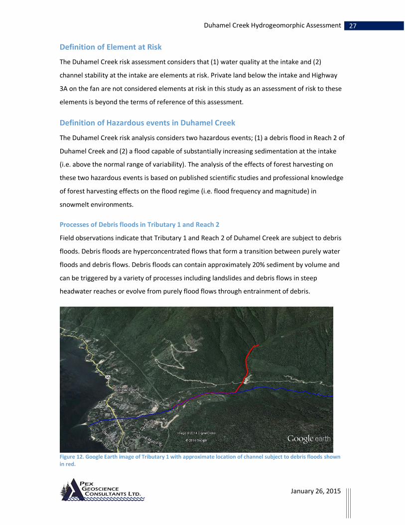
Figure 12. Google Earth image of Tributary 1 with approximate location of channel subject to debris floods shown in red.

28 Duhamel Creek Hydrogeomorphic Assessment
January 26, 2015
The moderate gradient (7-12%) and coarse textured bed of Duhanmel Creek below the
confluence of Tributary 1 suggests that debris floods that initiate in Tributary 1 (probably
initiating as debris flows or slush avalanches) continue for at least some distance downstream
once they enter Duhamel Creek. The red-highlighted channel in Figure 12 is an estimation of the
portion of Duhamel Creek impacted by debris floods originating in Tributary 1. The portion of
the Duhamel channel highlighted in red corresponds to Reach 2 and is confined on one or both
sides by boulder levee’s from past debris flood events.
A preliminary investigation of the hydroclimate conditions that trigger debris floods in Tributary
1 suggests that flood magnitude as well as flood duration are important factors. Hydrometric
data from Environment Canada for Five-Mile Creek indicate that the 1983 and 2012 floods were
similar magnitude however they differed substantially in flood duration. The 1983 flood, which
likely triggered the last debris flood in Tributary 1 recorded 7 consecutive days of discharge with
flood magnitude exceeding a 1:20 year flood while the 2012 flood was similarly elevated for only
1 day. Consequently in Tributary 1 the 2012 flood only resulted in overbank flooding and
localized scour of the channel banks and forest floor.
Floods capable of substantially increasing sedimentation at the intake
Dozens of snow avalanche/debris flow tributaries along the length of Duhamel Creek convey
sediment from steep headwater reaches to the main stem of Duhamel Creek on an annual basis.
Above Reach 2 much of this sediment (coarser than about 2mm) is deposited and stored in low
gradient wetland ‘settling ponds’ located along Duhamel Creek. Cumulatively, these wetland
segments store many thousands or possibly 100’s of thousands of cubic meters of fine grained
sediment.

29 Duhamel Creek Hydrogeomorphic Assessment
January 26, 2015
Photo 15. Typical wetland segment with sand, gravel and small cobble bed.
Because of the occurrence of numerous wetland segments along the length of Duhamel Creek,
only exceptional flood events such as the 2012 event (estimated as a 1:32 year flood in Duhamel
Creek) are capable of substantially increasing the rate of transport of the fine grained sediment.
Floods of this magnitude are also capable of breaking apart woody debris jams that are currently
storing large volumes of fine textured sediment along the length of Duhamel Creek.
Assessment of Consequence
Due to a limited knowledge of the vulnerability of the community waterworks to sedimentation
and channel instability the assessment undertaken here assumes that the consequence of a
hazardous event (debris flood and sediment-mobilizing flood) is ‘high’ – that is, that the
occurrence of these hazardous events will always cause damage to private land and waterworks
structure or cause long term impacts to water quality at the intakes.
Risk Assessment
The influence of forest harvesting on frequency of debris floods in Tributary 1.
Current Conditions
The naturally occurring hazard of a debris flood in Tributary 1 is assessed as ‘moderate’
according to Table 2. Floods with a sufficient magnitude and duration to initiate a debris flood
have a likelihood of occurrence of between 1:20 and 1:50. Combined with the high consequence

30 Duhamel Creek Hydrogeomorphic Assessment
January 26, 2015
of debris floods on the waterworks, the natural risk (without forest development) to the
waterworks from debris floods in Duhamel Creek is ‘high’.
Only a small area accounting for roughly 4 hectares of logging has occurred in Tributary 1 (Figure
2). The single cut block which was logged in the 1970’s or early 1980’s is partially regenerated
with an average stand height of 15 meters and a 40% crown closure. This existing block
represents an ECA of about 0.3% of the watershed area of Tributary 1. The existing level of
harvest represents no change in the existing hazard of a debris flood in Tributary 1.
Consequently there is no change in the existing ‘high’ risk to the waterworks from the current
level of forest harvesting in Duhamel Creek.
Proposed Harvesting (CP – 53)
CP 53 does not affect Tributary 1 and therefore represents no change in the existing hazard of
debris floods in Tributary 1 or risk of debris floods on the waterworks in Duhamel Creek.
The influence of forest harvesting on the frequency of sediment mobilizing floods
Current Conditions
Forest harvesting in snowmelt regions causes increases in snow accumulation and increases in
snowmelt rates relative to the forested condition (Buttle et al., 2005; Winkler et al., 2005; Ellis et
al., 2010)). Changes in snow accumulation and melt at the stand level can result in changes in
the flood regime at the watershed scale. Recent studies have shown that the influence of forest
harvesting on processes of snow accumulation and melt vary considerably with elevation and
aspect (Winkler et al., 2005; Jost et al., 2007; Ellis et al., 2010). These stand level studies reveal
that changes in hydrology at the stand level are linked directly to changes in net radiation at the
snowpack following harvesting. The greatest changes in net radiation following harvesting occur
on south and southwest aspect slopes and flat areas and are the result of large increases in
direct shortwave (solar) radiation (Ellis et al., 2010). The smallest increases in net radiation
following logging occur on north aspect slopes which are naturally shaded from the sun. West
aspect slopes appear to respond similarly to south aspect slopes in terms of changes in net
radiation following harvesting (Jost et al., 2007) however there are no studies to indicate how
east-aspect slopes respond to harvesting.
Interpreting the outcomes of stand level studies in terms of the potential watershed-scale
response is challenging. The results of stand level studies suggest that logging, when

31 Duhamel Creek Hydrogeomorphic Assessment
January 26, 2015
concentrated on north aspect slopes is likely to have a smaller influence on changes in the
magnitude and frequency of floods than when concentrated on south aspect slopes. However,
this outcome likely applies only to floods stemming from solar-radiation driven snowmelt that
occur early in the freshet period. Applying these stand level study outcomes to Duhamel Creek is
further complicated by the fact that slope aspects are primarily east - west rather than north -
south.
The current equivalent clear-cut area in Duhamel Creek is estimated at just over 9%. The
majority of this harvesting is situated below 1600 meters on slopes with east and northeast
aspects. Given the limited state of knowledge with respect to the potential for changes in the
frequency of large floods in steep east-west aspect watersheds a conservative assessment of
hazard is warranted. The outcomes of a hydrological modeling study undertaken in near-by
Redfish Creek for the ‘Current’ harvesting scenario (ECA = 9%) provides some indication of the
potential for changes in the flood regime in Duhamel Creek associated with the current
conditions. It is important to note that these two watersheds differ in that Redfish Creek has
relatively equal amounts of east, west and south aspect slopes and the harvesting scenarios
comprise openings that are distributed evenly around the basin (Schnorbus and Alila, 2004).
The results of the Redfish study shows that the current (9%) level of harvest results in no
substantial change in the frequency of large flood events. This study also shows that when
harvesting is evenly distributed across aspects in the lower one-third of the watershed, harvest
levels less than roughly 20% have no substantial influence on the flood regime. Similar results
were established in an earlier modeling exercise (Whitaker et al., 2001). This preliminary study
also found that cutblocks located in the lower 20% of the watershed had no obvious effects on
flood peaks. These modeling outcomes agree with an empirical study of the snowline retreat in
Redfish Creek which determined that snow has mostly melted from slopes in the lower third of
the watershed when peak flows occur in Redfish Creek (Gluns, 2001). Based on these studies the
current level of harvest in Duhamel Creek, the majority of which is situated on slopes mostly
below 1350 meters (corresponding to the lower 34% of the watershed area, Figure 13), is
unlikely to change the existing frequency of large flood events (i.e. 1:20 year or greater) or the
existing risk of sedimentation events at the intake.

32 Duhamel Creek Hydrogeomorphic Assessment
January 26, 2015
Figure 13. Duhamel hypsometric curve. 1350m elevation corresponds to the lower 1/3 (33%) of the watershed.
Proposed Harvesting (CP-53)
Three additional blocks are proposed as part of CP 53. These blocks, which have a cumulative
area of slightly less than 45 hectares, will bring the total ECA up to 579 hectares or 10.4% of the
watershed area above the uppermost intake. All three of the proposed blocks are situated in
the lower third of the watershed below 1350 meters. The results of the Redfish Creek studies
mentioned above (Whitaker et al., 2002, Schnorbus and Alila, 2004) suggests that the proposed
harvesting will have no detectable influence on the frequency distribution of floods and
therefore no change in risk of sedimentation events at the intake.
7. Summary and Recommendations for Forest Management
Summary
Sediment Delivery
Duhamel Creek is a very active fluvial system situated in steep V-shaped valley that receives
sediment and debris from a multitude of steep snow avalanche/debris flow tributaries located
along its length. The colluvial cones at the base of these avalanche gullies constrict the valley
bottom of Duhamel Creek forming low gradient wetland reaches upstream and steeper cascade
segments in the constricted segments. The low gradient wetlands trap and store many
thousands of cubic meters of sediment larger than about sand size in all but the largest flood
events.
Three road-related landslides have entered Duhamel Creek over the last 17 years. In all cases
the slides were caused by concentration and diversion of surface and subsurface runoff along
roads and trails. Sediment from the 1997 debris flow is still evident in Duhamel Creek for
33 Duhamel Creek Hydrogeomorphic Assessment
January 26, 2015
approximately 200 meters downstream from the tributary confluence. Vegetation established
on the slide deposits has stopped surface erosion from contributing fine sediment to the
channel.
Peak flows and channel forming floods
Duhamel Creek displays a well-developed downstream hydraulic geometry indicating its
morphology is a function of the contemporary flow regime. In most years peak flows in Duhamel
Creek are driven by snowmelt from upper elevation slopes. Exceptional floods can occur
following several days of very warm weather (i.e., temperatures of 25oC in Nelson) and/or large
rainfall on snowmelt events. The last channel forming flood event appears to have occurred
roughly 30 years ago (likely 1983). During this prolonged runoff event, which was triggered by
several consecutive days of warm spring temperatures, a debris flood initiated in Tributary 1
that traveled for a considerable distance down Duhamel Creek.
The current level of forest harvesting (9.6%) is assessed as having a low likelihood of increasing
the frequency of debris floods that could pose a risk to the integrity of water intakes or
increasing the frequency of flood events that create a risk of sedimentation at the intakes.
Likewise, proposed harvesting of CP 53 which brings the ECA to 10.4% is also assessed as having
a low likelihood of increasing the frequency of these hazardous events and therefore will not
increase the risk of these hazardous events on the intake.
Riparian function
Large woody debris recruited from the adjacent riparian stand plays an important role in
Duhamel Creek with respect to channel bed structure and aquatic habitat. Riparian function
along the entire length of Duhamel Creek from Six-Mile Lakes to the fan has experienced
extensive disturbance from early 1900’s logging activities. Although the majority of Duhamel
Creek currently displays stable, vegetated channel banks the majority of the woody debris in the
stream channel is very old, rotten and broken and has cut ends indicating it was deposited in the
channels during the early logging activities. Much of this old LWD is distributed along the
channel in very large woody debris jams that are partially functioning to retain fine textured
sediment or as accumulations of broken woody debris pieces along the upper channel banks.
Over the next few decades it is likely that greater volumes of fine sediment will be release from
behind these decomposing jams as they continue to break apart during flood event. The existing

34 Duhamel Creek Hydrogeomorphic Assessment
January 26, 2015
riparian stand, which comprises mature cedar and hemlock stands with basal diameters
exceeding 50 cm, is just starting to contribute woody debris to the stream channel.
Recommendations
Level of Harvest and harvest distribution
Hydrological modeling undertaken in Redfish Creek suggests that harvest levels below
approximately 20% when situated across aspects in the lower third of the watershed will not
result in detectable changes in the frequency distribution of floods (i.e. have a low likelihood for
increasing the existing frequency of the hazardous event). Currently the majority of blocks in
Duhamel Creek are situated on a single aspect (E - NE). Concentrating harvesting on a single
aspect is more likely to increase synchronization of runoff from a watershed compared to
distributing blocks across aspects. A recent study by Green and Alila, 2012 found that the effects
of harvesting on the flood regime are increased where harvesting functions to increase the
synchronization of runoff from slopes. To maintain a low likelihood of altering the frequency of
larger floods it is recommended that harvest levels in Duhamel Creek be limited to less than 20%
and any future blocks should be planned so as to balance the cut across aspects on slopes below
1350m elevation.
If future harvesting is concentrated on western slopes over a broader elevation range rather
than distributed across aspects below 1350m changes in the frequency of flooding may occur at
lower levels of harvesting. Although there are currently no studies that can be used to establish
definitively the potential hydrological impacts of concentrating harvesting on a single (east)
aspect slope the outcomes of modeling studies in Redfish Creek suggest that harvesting of
roughly 20% of the watershed with 13% situated in central 2/3 elevations between the H60 and
H40 (Schnorbus and Alila, 2004) has the potential to increase the magnitude of floods by
approximately 4% over a range of return periods. As with Green and Alila (2012) this study
determined that increases in runoff synchronization between various elevation bands largely
drive the magnitude of change in peak flows. If future harvesting in Duhamel were to be
concentrated on a single aspect and include slopes between 1350 meters and 1700 meters
rather than a distributed across aspects it is likely that the increases in peak flows could be
substantially larger than those reported in the modeling studies because of the greater increase
in runoff synchronization. The effect of an increase of just 8% in peak flow magnitude (i.e.
double the increase reported for a distributed cut) has the effect of increasing the frequency of

35 Duhamel Creek Hydrogeomorphic Assessment
January 26, 2015
the hazardous event (20 year return period flood) by over 2 times (20 year to about 7.5 year RI)
(see black arrow in Figure 13). This increases the probability of a damaging flood from moderate
to high (Table 2).
Figure 14. Hypothetical change in frequency if harvesting of 20% of the watershed area is concentrated on a single aspect slope. The blue diamonds show the ranked distribution of floods from the actual 19 years of flow data from Duhamel Creek. The red squares show the estimated flood frequency distribution using the Log Pearson III function which is calculated using the 19 years of gauging in Duhamel Creek. The green triangles show the estimated ranked distribution of floods given an 8% increase in flood magnitude across the full range of return periods.
Harvesting on active debris flow and snow avalanche fans/cones
Harvesting on the fans and cones of active debris flow/debris flood tributaries (such as Tributary
1) should be undertaken with exceptional care as harvesting in these areas can increase channel
instability (See BC FLNRO, LMH 56). Clear-cut harvesting on debris flow and fluvial fans reduces
the natural erosion protection afforded by the root networks of coniferous trees. Proposed
harvesting in the vicinity of fans should include an assessment by a qualified professional to
delineate the potential extent of the fan/cone landform, an assessment of the frequency of
debris flood events, and prescriptions to maintain a sufficient density of mature coniferous
stems to maintain forest floor integrity over the period of the regenerating stand.
To limit the potential for increasing the frequency of debris floods harvesting in Tributary 1
should be limited to less than 5% of the watershed area of Tributary 1 and should be limited to
south aspect slopes or low elevation slopes (below 1100m). Similar limitations are also
recommended for the debris flow tributary directly south of Tributary 1 which shares the same
fan and appears to carry debris flows with a similar frequency.

36 Duhamel Creek Hydrogeomorphic Assessment
January 26, 2015
Road construction and deactivation
Several slides have occurred in Duhamel Creek as a result of concentrated and diverted runoff
along roads and trails. Roads and trails on or above unstable or potentially unstable slopes must
be designed and deactivated by a Qualified Registered Professional experienced in terrain
stability mapping and assessment and resource road design (QRP) to avoid concentrating and
diverting surface and subsurface runoff. Drainage structures are to be sized to accommodate
increased surface flows following harvesting. Projected climate change scenarios for the West
Kootenay region suggests that fall, winter and spring rain-on-snow events could become more
frequent (Appendix 3). Roads and trails on low elevation slopes, especially those situated in or
below cutblocks could experience a higher frequency of high intensity runoff events in future
decades compared to the recent past.
Riparian Management to maintain ecosystem function
Riparian vegetation plays an important role in Duhamel Creek with respect to channel stability
and protection to the channel bank and adjacent floodplain during overbank floods. In addition
riparian vegetation along reaches 3 to 6 provides valuable terrestrial and aquatic habitat for
beaver, ungulates, raptors, waterfowl and many wetland species. Riparian management
strategies to maintain channel and riparian ecosystem integrity along the main stem (S2)
channel in Duhamel Creek are provided in draft form in Volume 2 of the Integrated Riparian
Assessment document Detailed Riparian Management Strategies (Apex, 2013, Draft document).
Additional riparian management strategies to maintain physical ecosystem function along S3 to
S6 streams in Duhamel Creek are also contained in the draft Detailed Riparian Management
Strategies document.

37 Duhamel Creek Hydrogeomorphic Assessment
January 26, 2015
8. Closure and Limitations
The information in this hydrological assessment report is for the sole use of Kalensikoff Lumber
Company Ltd of Thrums, BC and is intended to provide guidance for forest management in
Duhamel Creek. The recommendations in this report are based on field observation of active
hydrologic and geomorphologic processes in the watershed and on historical data collected
from various sources. In addition, assessment of hazard presented in this report considers the
results of numerous recent studies from BC and North America that identify the effects of
harvesting on hydrologic response of interior snowmelt dominated mountainous watersheds.
The hazard assessment and recommendations provided here are precautionary in nature due to
the limited availability of hydrological studies relevant to Duhamel Creek. A more accurate
assessment of the hydrological effects of logging in Duhamel Creek would be achieved by
undertaking a modeling exercise to better quantify the effects of canopy removal in a watershed
with steep east – west aspect slopes.
Fluvial geomorphology data collected during this assessment quantify the existing channel
conditions. This data can be used to compare against channel condition during future channel
assessments to determine if there have been changes.
______________________________________ Kim Green, P.Geo, PhD Apex Geoscience Consultants Ltd. Nelson, B.C.

38 Duhamel Creek Hydrogeomorphic Assessment
January 26, 2015
9. Literature Cited
Apex, 2004. Duhamel Creek Hydro-geomorphic Assessment and Risk Analysis. Prepared for Kalesnikoff Lumber Co. Ltd., Thrums B.C.
Buttle, J.M., C.J. Oswald, and D.T. Woods. 2005. Hydrologic recovery of snow accumulation and melt following harvesting in northeastern Ontario. In Proceedings of the 62nd Annual Eastern Snow Conference, June 7–10, 2005, Waterloo, Ont., pp. 83–91.
Ellis, C.R., Pomeroy, J.W., Essery, R.L.H., and Link, T.E., 2010. Effects of needle-leaf forest cover on radiation and snowmelt dynamics in the Canadian Rocky Mountains, Canadian Journal of Forest Research, 41, 608–620, doi:10.1139/X10-227.
Gluns, D. R. (2001), Snowline pattern during the melt season: Evaluation of the H60 concept, in
Watershed Assessment in the Southern Interior of British Columbia, Working Pap.
57/2001, edited by D. A. A. Toews and S. Chatwin, pp. 68 – 80, Res. Branch, British
Columbia Minist. of For., Victoria, British Columbia, Canada.
Green, K. C., and Y. Alila (2012), A paradigm shift in understanding and quantifying the effects of forest harvesting on floods in snow environments, Water Resour. Res., 48, W10503, doi:10.1029/2012WR012449
Jost, G., Weiler, M., Gluns, D.R., and Alila, Y., 2007. The influence of forest and topography on snow accumulation and melt at the watershed-scale. Journal of Hydrology 347, 101-115. doi:10.1016/j.jhydrol.2007.09.006
Schnorbus, M., and Y. Alila (2004), Forest harvesting impacts on the peak flow regime in the Columbia Mountains of southeastern British Columbia: An investigation using long-term numerical modeling, Water Resour. Res., 40, W05205,doi:10.1029/2003WR002918
Whitaker, A., Y. Alila, J. Beckers, and D. Toews, 2002. Evaluating peak flow sensitivity to clear-cutting in different elevation bands of a snowmelt-dominated mountainous catchment, Water Resour. Res., 38(9), 1172, doi:10.1029/2001WR000514.
Wilford, D.J., Sakals, ME., Grainger WW., Millard., TH, and TR Giles., 2009. Managing forested watersheds for hydrogeomorphic risk on fans. B.C., Min.For. Range., For. Sci. Prog. Victoria BD., Land Manag., Handb. 61. www.for.gov.bc.ca/hfd/pubs/Docs/Lmh/Lmh61.htm
Winkler RD, Spittlehouse DL, and DL, Golding, 2005. Measured differences in snow accumulation and melt among clearcut, juvenile, and mature forests in southern British Columbia. Hydrological Processes 19: 51–62.
Wise, MP., Moore, GD., and D.F. VanDine (editors), 2004. Landslide risk case studies in forest development planning and operations, B.C., Min, For., Res., Br., Victoria, B.C., Land Manag. Handb. 56. www.for.gov.bc.ca/hfd/pubs/Docs/Lmh/Lmh56.htm

39 Duhamel Creek Hydrogeomorphic Assessment
January 26, 2015
Appendix 1 Water License information
Downloaded from http://a100.gov.bc.ca/pub/wtrwhse/water_licences.input (September 2014)
Licence No
WR Map/ Purpose Quantity Units Licensee Priority Date
Issue Date
C028761 5230C HH (PD27725)
Domestic 1.514 MD WORKING PROJECTS INC 18990619
724 2ND STREET NELSON BC V1L2L9
" " Irrigation 12951.54 MY WORKING PROJECTS INC 18990619
724 2ND STREET NELSON BC V1L2L9
C028762 5230B X (PD27704)
Domestic 2.273 MD KOHOUT JERRY GEORGE & CAROLYN ROSE KELLY
18990619
2728 HWY 3A NELSON BC V1L6L6
" " Irrigation 419.383 MY KOHOUT JERRY GEORGE & CAROLYN ROSE KELLY
18990619
2728 HWY 3A NELSON BC V1L6L6
" 5230B Z4 (PD27714)
Domestic 2.273 MD KOHOUT JERRY GEORGE & CAROLYN ROSE KELLY
18990619
2728 HWY 3A NELSON BC V1L6L6
" " Irrigation 419.383 MY KOHOUT JERRY GEORGE & CAROLYN ROSE KELLY
18990619
2728 HWY 3A NELSON BC V1L6L6
C029513 5230B A5 (PD27709)
Domestic 2.273 MD HOWARD ALLAN C & DOREEN A 18990619
2813 HWY 3A NELSON BC V1L6M1
" 5230B X3 (PD27705)
Domestic 2.273 MD HOWARD ALLAN C & DOREEN A 18990619
2813 HWY 3A NELSON BC V1L6M1
C031153 5230C Z (PD27728)
Domestic 1.818 MD WHITEHEAD WATERWORKS DISTRICT
19030512
BOX 845 NELSON BC V1L6A5
" " Irrigation Local Auth
5920.704 MY WHITEHEAD WATERWORKS DISTRICT
19030512
BOX 845 NELSON BC V1L6A5
C031341 5230C AA (PD27733)
Domestic 1.137 MD HARRISON DOUGLAS W & TETZ BRENDA L
18990619
3129 HEDDLE ROAD NELSON BC V1L6M2
" " Irrigation 3873.127 MY HARRISON DOUGLAS W & TETZ BRENDA L
18990619
3129 HEDDLE ROAD NELSON BC V1L6M2
C032639 5230B L5 (PD27717)
Domestic 2.273 MD KELLY CAROLYN R 19631009
2737 LOWER SIX MILE ROAD NELSON BC V1L6L5
C041300 5230B R5 (PD27716)
Irrigation 937.445 MY PRIVE MADELEINE 18990619
2727 LOWER SIX MILE RD NELSON BC V1L6L5
" 5230B X (PD27704)
Irrigation 937.445 MY PRIVE MADELEINE 18990619
2727 LOWER SIX MILE RD NELSON BC V1L6L5
C045010 5230C Z (PD27728)
Domestic 2.273 MD WHITEHEAD WATERWORKS DISTRICT
19730518
BOX 845 NELSON BC V1L6A5

40 Duhamel Creek Hydrogeomorphic Assessment
January 26, 2015
Licence No
WR Map/ Purpose Quantity Units Licensee Priority Date
Issue Date
C046225 5230C AA (PD27733)
Irrigation 5402.642 MY HEDDLE MARILYN H 19030331
108 2828 YEW ST VANCOUVER BC V6K4W5
C046438 5230C AA (PD27733)
Domestic 2.273 MD MCGRATH DAVID C & VICKY M 19050530
C/O WILLIAM MCGRATH 5815 PARKVIEW DR VERMILION AB T9X1V9
C052965 5230C CC (PD27729)
Irrigation Local Auth
1110.132 MY WHITEHEAD WATERWORKS DISTRICT
19260929
BOX 845 NELSON BC V1L6A5
C052966 5230C CC (PD27729)
Irrigation Local Auth
407.048 MY WHITEHEAD WATERWORKS DISTRICT
19260929
BOX 845 NELSON BC V1L6A5
C052968 5230C CC (PD27729)
Domestic 2.273 MD WHITEHEAD WATERWORKS DISTRICT
19341102
BOX 845 NELSON BC V1L6A5
C052969 5230C CC (PD27729)
Domestic 2.273 MD WHITEHEAD WATERWORKS DISTRICT
19341102
BOX 845 NELSON BC V1L6A5
C052971 5230C CC (PD27729)
Irrigation Local Auth
12088.1 MY WHITEHEAD WATERWORKS DISTRICT
18990619
BOX 845 NELSON BC V1L6A5
C052972 5230C CC (PD27729)
Irrigation Local Auth
616.74 MY WHITEHEAD WATERWORKS DISTRICT
19260929
BOX 845 NELSON BC V1L6A5
C052973 5230C CC (PD27729)
Irrigation Local Auth
2343.612 MY WHITEHEAD WATERWORKS DISTRICT
19380510
BOX 845 NELSON BC V1L6A5
C052974 5230C CC (PD27729)
Irrigation Local Auth
530.396 MY WHITEHEAD WATERWORKS DISTRICT
19260929
BOX 845 NELSON BC V1L6A5
C053147 5230C CC (PD27729)
Irrigation Local Auth
1554.185 MY WHITEHEAD WATERWORKS DISTRICT
18990619
BOX 845 NELSON BC V1L6A5
C053148 5230C CC (PD27729)
Irrigation Local Auth
1578.854 MY WHITEHEAD WATERWORKS DISTRICT
18990619
BOX 845 NELSON BC V1L6A5
C053149 5230C CC (PD27729)
Irrigation Local Auth
1233.48 MY WHITEHEAD WATERWORKS DISTRICT
18990619
BOX 845 NELSON BC V1L6A5
C053150 5230C CC (PD27729)
Irrigation Local Auth
1788.546 MY WHITEHEAD WATERWORKS DISTRICT
18990619
BOX 845 NELSON BC V1L6A5
C053151 5230C CC (PD27729)
Irrigation Local Auth
1591.189 MY WHITEHEAD WATERWORKS DISTRICT
18990619
BOX 845 NELSON BC V1L6A5
C053488 5230C R4 (PD27732)
Domestic 2.273 MD JONES GLEN V & MARIAN 18990619
2899 DUHAMEL ROAD NELSON BC V1L6L9
" " Irrigation 42555.06 MY JONES GLEN V & MARIAN 18990619
2899 DUHAMEL ROAD NELSON BC V1L6L9
C053524 5230C W (PD27726)
Irrigation Local Auth
3293.392 MY WHITEHEAD WATERWORKS DISTRICT
19090222

41 Duhamel Creek Hydrogeomorphic Assessment
January 26, 2015
Licence No
WR Map/ Purpose Quantity Units Licensee Priority Date
Issue Date
BOX 845 NELSON BC V1L6A5
C053525 5230C T4 (PD62414)
Irrigation Local Auth
1467.841 MY WHITEHEAD WATERWORKS DISTRICT
19090222
BOX 845 NELSON BC V1L6A5
C053526 5230C T4 (PD62414)
Irrigation Local Auth
1332.158 MY WHITEHEAD WATERWORKS DISTRICT
19090222
BOX 845 NELSON BC V1L6A5
C054698 5230C AA (PD27733)
Domestic 2.273 MD BOYER DWAIN & SHEILA 19790418
3196 HEDDLE RD NELSON BC V1L6M2
C054699 5230C AA (PD27733)
Domestic 2.273 MD BROCK RAY L 19790621
3185 HEDDLE RD NELSON BC V1L6M2
C054700 5230C AA (PD27733)
Domestic 2.273 MD DREHER BRADLEY RICHARD 19790621
3195 HEDDLE ROAD NELSON BC V1L6M2
C055296 5230C CC (PD27729)
Irrigation Local Auth
12334.8 MY WHITEHEAD WATERWORKS DISTRICT
19770804
BOX 845 NELSON BC V1L6A5
C055661 5230C CC (PD27729)
Waterworks Local Auth
33186.46 MY WHITEHEAD WATERWORKS DISTRICT
19800121
BOX 845 NELSON BC V1L6A5
C055662 5230C T4 (PD62414)
Domestic 2.273 MD WHITEHEAD WATERWORKS DISTRICT
19790801
BOX 845 NELSON BC V1L6A5
C056180 5230C T4 (PD62414)
Domestic 2.273 MD WHITEHEAD WATERWORKS DISTRICT
19790801
BOX 845 NELSON BC V1L6A5
C056568 5230C AA (PD27733)
Domestic 2.273 MD WOOLLS GARY N 19800611
518 SILICA ST NELSON BC V1L4M9
C056954 5230C AA (PD27733)
Domestic 2.273 MD INGRAHAM DAVID BRUCE 19030331
3170 HEDDLE ROAD NELSON BC V1L6M2
C057553 5230C AA (PD27733)
Domestic 2.273 MD NESBITT MICHAEL C & MARY L 19810205
3149 HEDDLE RD NELSON BC V1L6M2
C057557 5230C AA (PD27733)
Domestic 2.273 MD FLEET RICHARD & LANDRY STEPHANIE
19810710
2988 HEDDLE RD NELSON BC V1L6Z8
C057558 5230C AA (PD27733)
Domestic 2.273 MD PHILLIPS LORI K & KEITH D 19810710
2994 HEDDLE RD NELSON BC V1L6Z8
C057559 5230C AA (PD27733)
Domestic 2.273 MD MISAN DALE S & LORRI L 19810710
3018 HEDDLE RD NELSON BC V1L6Z8
C057560 5230C AA (PD27733)
Domestic 2.273 MD BACHYNSKI ROBERT S & SHANNON L
19810710
6212 SILVER RIDGE DR NW CALGARY AB T3B3S7
C057807 5230C HH (PD27725)
Domestic 2.273 MD ZAITSOFF ARNOLD G 18990619

42 Duhamel Creek Hydrogeomorphic Assessment
January 26, 2015
Licence No
WR Map/ Purpose Quantity Units Licensee Priority Date
Issue Date
2821 GREENWOOD ROAD NELSON BC V1L6L3
C058284 5230C AA (PD27733)
Domestic 2.273 MD COBURN NEIL & ALISON K 19810202
3186 HEDDLE RD NELSON BC V1L6M2
C059980 5230C HH (PD27725)
Domestic 2.273 MD NICHOLAS LINCOLN T & VALDA M 19820531
2747 GREENWOOD RD NELSON BC V1L6L2
C062535 5230C CC (PD27729)
Domestic 2.273 MD STEIN JUERGEN 19810914
2961 SIX MILE LAKES ROAD NELSON BC V1L6W3
C062547 5230C CC (PD27729)
Domestic 2.273 MD GIBSON VALERIE J 19840507
2919 SIX MILE LAKES ROAD NELSON BC V1L6W3
C072691 5230C CC (PD27729)
Domestic 2.273 MD GRAYCHICK SCOTT P 19860612
504 ANDERSON ST NELSON BC V1L3Y4
C100405 5230C AA (PD27733)
Domestic 2.273 MD MCGRATH DAVID C & VICKY M 19871029
19941114
C/O WILLIAM MCGRATH 5815 PARKVIEW DR VERMILION AB T9X1V9
C100426 5230C AA (PD27733)
Domestic 2.273 MD WILKINSON TANDI L 19890905
19940704
3210 HEDDLE RD NELSON BC V1L6M2
C102516 5230C CC (PD27729)
Domestic 2.273 MD HARLOW L DANIEL & DEIDRE I 19910711
19941114
2951 SIX MILE LAKES RD NELSON BC V1L6W3
C104353 5230C AA (PD27733)
Domestic 1.137 MD WHITE ERIC R & BOWERS VIVIEN E 18990619
19920529
3093 HEDDLE RD NELSON BC V1L6M2
" " Irrigation 2911.013 MY WHITE ERIC R & BOWERS VIVIEN E 18990619
19920529
3093 HEDDLE RD NELSON BC V1L6M2
C104354 5230C AA (PD27733)
Irrigation 912.775 MY UPPER CRAIG M 18990619
19920529
3111 HEDDLE RD NELSON BC V1L6M2
C104355 5230C AA (PD27733)
Irrigation 1184.141 MY WOOLLS GARY N 18990619
19920529
518 SILICA ST NELSON BC V1L4M9
C104359 5230C AA (PD27733)
Domestic 2.273 MD NEWELL THOMAS H 19030331
19920529
3224 HEDDLE RD NELSON BC V1L6M2
" " Res. Lawn/Garden
925.11 MY NEWELL THOMAS H 19030331
19920529
3224 HEDDLE RD NELSON BC V1L6M2
C104800 5230C HH (PD27725)
Domestic 2.273 MD JOHNSON DANIEL L & SHERYL K 19920527
19950728
2852 HARLOW RD NELSON BC V1L6L3
C106051 5230C CC (PD27729)
Res. Lawn/Garde
1233.48 MY SUGGITT HOLLY KATHLEEN 19051116
19930726

43 Duhamel Creek Hydrogeomorphic Assessment
January 26, 2015
Licence No
WR Map/ Purpose Quantity Units Licensee Priority Date
Issue Date
n
6102 WINDSOR STREET VANCOUVER BC V5W3J3
C106755 5230B C6 (PD67902)
Domestic 2.273 MD OLSSON CARL H & NIKKI L 19930621
19951027
2805 HWY 3A NELSON BC V1L6M1
C107644 5230C AA (PD27733)
Domestic 2.273 MD ROBINSON DAVID S 19050530
19940803
3063 MILLER RD NELSON BC V1L6Z6
C107646 5230C AA (PD27733)
Res. Lawn/Garden
1233.48 MY ENGSTAD PHILIP C & CAROLLE D 19050530
19940803
3140 KENIRIS RD NELSON BC V1L6Z8
C107647 5230C AA (PD27733)
Res. Lawn/Garden
1233.48 MY MOONEY KIMBERLY E 19050530
19940803
3150 KENIRIS RD NELSON BC V1L6Z8
C107649 5230C AA (PD27733)
Res. Lawn/Garden
1233.48 MY KRISTENSEN HANS ELMEGAARD & MURPHY COLLE
19050530
19940803
JOHANNES VERHULSTSTRAAT 1 1071NC AMSTERDAM NETHERLANDS
C109542 5230C HH (PD27725)
Domestic 2.273 MD VILLALUZ CATHERINE J & SCHELLENBERG PAUL
19831115
19950728
31741 TOWNSHIPLINE RD ABBOTSFORD BC V4X1W4
C111034 5230C HH (PD27725)
Domestic 2.273 MD FISCHER CATHERINE A 19960515
20040315
2755 GREENWOOD RD NELSON BC V1L6L2
C111044 5230C T4 (PD62414)
Processing 4.546 MD RENNIE JOHN ET AL 19090222
19960823
PO BOX 3155 STN MAIN CASTLEGAR BC V1N3H5
C111645 5230C AA (PD27733)
Domestic 2.273 MD SUTHERLAND HUNT ADAMS & TYRRELL MARGERY
19601124
19980908
3114 HEDDLE ROAD NELSON BC V1L6M2
C111749 5230C AA (PD27733)
Domestic 2.273 MD LEONG ROSE M 19050530
19961127
3134 HEDDLE RD NELSON BC V1L6M2
" " Irrigation 11101.32 MY LEONG ROSE M 19050530
19961127
3134 HEDDLE RD NELSON BC V1L6M2
C111750 5230C AA (PD27733)
Res. Lawn/Garden
1850.22 MY SUTHERLAND HUNT ADAMS & TYRRELL MARGERY
19050530
19961127
3114 HEDDLE ROAD NELSON BC V1L6M2
C111752 5230C AA (PD27733)
Res. Lawn/Garden
11829.07 MY STRATA CORPORATION NES190 19941213
19961127
STRATA CORP NES 190 3180 THE MIDDLE RD NELSON, BC V1L6M3
" " Waterworks (Other)
27.277 MD STRATA CORPORATION NES190 19941213
19961127
STRATA CORP NES 190 3180 THE MIDDLE RD NELSON, BC V1L6M3

44 Duhamel Creek Hydrogeomorphic Assessment
January 26, 2015
Licence No
WR Map/ Purpose Quantity Units Licensee Priority Date
Issue Date
C111831 5230C F5 (PD73375)
Domestic 2.273 MD WATT GORDON A & YVONNE 19051116
19971210
2910 SIX MILE ROAD NELSON BC V1L6W3
" " Irrigation 10262.55 MY WATT GORDON A & YVONNE 19051116
19971210
2910 SIX MILE ROAD NELSON BC V1L6W3
C111832 5230C C5 (PD73372)
Domestic 2.273 MD COLBECK JOHN D & SCHUTTER SNOWFLOWER
19051116
19971210
2990 SIX MILE LAKES RD NELSON BC V1L6W3
C111834 5230C E5 (PD73374)
Domestic 2.273 MD JACOBSON HELGA & HYDE NAIDA D
19051116
19971210
2873 DUHAMEL ROAD NELSON BC V1L6L9
C111950 5230C AA (PD27733)
Domestic 2.273 MD FLETT STEPHEN J & JANICE 18990619
19970201
3087 HEDDLE RD NELSON BC V1L6M2
" " Irrigation 1480.176 MY FLETT STEPHEN J & JANICE 18990619
19970201
3087 HEDDLE RD NELSON BC V1L6M2
C112068 5230C AA (PD27733)
Domestic 2.273 MD WALL EDWIN P & SWENSON JULIE K
19050530
19970312
3048 HEDDLE RD NELSON BC V1L6Z8
C112243 5230C HH (PD27725)
Domestic 2.273 MD MELATINI JOSEPH C 19721201
19970526
BOX 877 NELSON BC V1L6A5
C112969 5230C AA (PD27733)
Res. Lawn/Garden
1233.48 MY GIBBON JOHN A 19980209
19981005
3120 KENIRIS RD NELSON BC V1L6Z8
C113063 5230C T4 (PD62414)
Domestic 2.273 MD FLETTE MARK L & COLLEEN A 19980309
20040304
C/O 10618 81 AVE GRANDE PRAIRIE AB T8W2H2
C113714 5230C AA (PD27733)
Domestic 2.273 MD TURNER IRIS A 19050530
19990202
829 NELSON AVENUE NELSON BC V1L2N8
" " Irrigation 34081.05 MY TURNER IRIS A 19050530
19990202
829 NELSON AVENUE NELSON BC V1L2N8
C113971 5230C AA (PD27733)
Domestic 4.546 MD TIMMERMANS LAURIE A 19050530
19991122
3067 MILLER RD NELSON BC V1L5P4
" " Irrigation 1899.559 MY TIMMERMANS LAURIE A 19050530
19991122
3067 MILLER RD NELSON BC V1L5P4
C113972 5230C AA (PD27733)
Domestic 2.273 MD GRANT RICHARD A & GAY H 19050530
19991122
3065 MILLER RD NELSON BC V1L6Z8
" " Res. Lawn/Garden
567.401 MY GRANT RICHARD A & GAY H 19050530
19991122
3065 MILLER RD NELSON BC

45 Duhamel Creek Hydrogeomorphic Assessment
January 26, 2015
Licence No
WR Map/ Purpose Quantity Units Licensee Priority Date
Issue Date
V1L6Z8
C114053 5230C AA (PD27733)
Domestic 2.273 MD SAUTER ULRICH 18990619
19990831
3075 HEDDLE RD NELSON BC V1L6M2
" " Irrigation 2725.991 MY SAUTER ULRICH 18990619
19990831
3075 HEDDLE RD NELSON BC V1L6M2
C114054 5230C AA (PD27733)
Res. Lawn/Garden
740.088 MY YAKIMOV MARGARET 18990619
19990831
3071 HEDDLE ROAD NELSON BC V1L6M2
C114055 5230C AA (PD27733)
Res. Lawn/Garden
838.766 MY VAN NEST KLEIN ALISON J 18990619
19990831
3067 HEDDLE RD NELSON BC V1L6M2
C114899 5230C AA (PD27733)
Irrigation 4317.18 MY UPPER CRAIG M 18990619
20000412
3111 HEDDLE RD NELSON BC V1L6M2
C114950 5230C AA (PD27733)
Res. Lawn/Garden
1270.484 MY MANSON VICTOR N & KATHLEEN N 18990619
20000928
3065 HEDDLE RD NELSON BC V1L6M2
C114951 5230C AA (PD27733)
Res. Lawn/Garden
1433.304 MY PISANO ANTONIO & BERGMAN JODI M
18990619
20000928
3021 HEDDLE ROAD NELSON BC V1L6Z8
C114982 5230C AA (PD27733)
Domestic 2.273 MD HANLEY WILLIAM DAVID & FOSTER PATRICIA A
18990619
20010118
3181 HEDDLE ROAD NELSON BC V1L6M3
C114983 5230C AA (PD27733)
Domestic 2.273 MD FURROW EDWARD THOMAS & SETTER SANDRA JAN
18990619
20010118
3179 HEDDLE ROAD NELSON BC V1L6M2
C114984 5230C AA (PD27733)
Domestic 2.273 MD FARAGUNA ALLAN M & MELISSA A 18990619
20010118
3169 HEDDLE ROAD NELSON BC V1L6M2
C115039 5230C AA (PD27733)
Domestic 2.273 MD MANSON VICTOR N & KATHLEEN N 19781220
20000929
3065 HEDDLE RD NELSON BC V1L6M2
C115040 5230C AA (PD27733)
Domestic 2.273 MD PISANO ANTONIO & BERGMAN JODI M
19781220
20000928
3021 HEDDLE ROAD NELSON BC V1L6Z8
C115757 5230C AA (PD27733)
Domestic 2.273 MD UPPER CRAIG M 19800611
20010327
3111 HEDDLE RD NELSON BC V1L6M2
C118015 5230C R4 (PD27732)
Domestic 2.273 MD JONES MICHAEL L & BERNICE M 20030210
20040308
2905 DUHAMEL RD NELSON BC V1L6L5
C119652 5230C AA (PD27733)
Domestic 2.273 MD DOWDEN CHERYL L 19050530
20041101
3053 KENIRIS RD NELSON BC
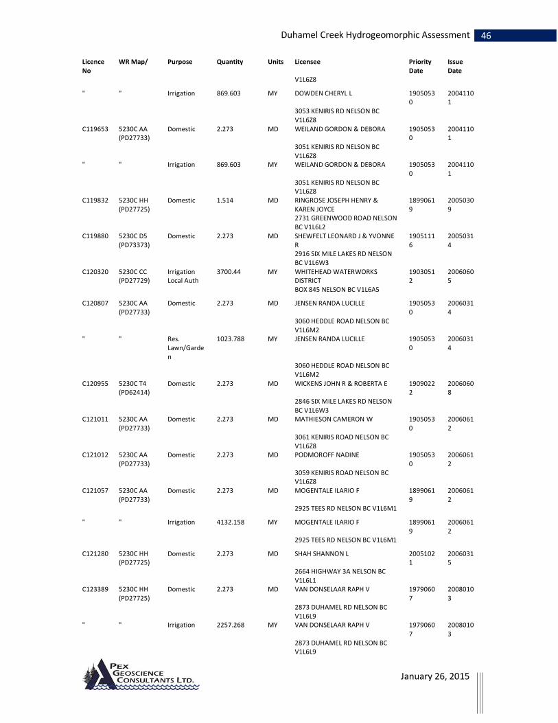
46 Duhamel Creek Hydrogeomorphic Assessment
January 26, 2015
Licence No
WR Map/ Purpose Quantity Units Licensee Priority Date
Issue Date
V1L6Z8
" " Irrigation 869.603 MY DOWDEN CHERYL L 19050530
20041101
3053 KENIRIS RD NELSON BC V1L6Z8
C119653 5230C AA (PD27733)
Domestic 2.273 MD WEILAND GORDON & DEBORA 19050530
20041101
3051 KENIRIS RD NELSON BC V1L6Z8
" " Irrigation 869.603 MY WEILAND GORDON & DEBORA 19050530
20041101
3051 KENIRIS RD NELSON BC V1L6Z8
C119832 5230C HH (PD27725)
Domestic 1.514 MD RINGROSE JOSEPH HENRY & KAREN JOYCE
18990619
20050309
2731 GREENWOOD ROAD NELSON BC V1L6L2
C119880 5230C D5 (PD73373)
Domestic 2.273 MD SHEWFELT LEONARD J & YVONNE R
19051116
20050314
2916 SIX MILE LAKES RD NELSON BC V1L6W3
C120320 5230C CC (PD27729)
Irrigation Local Auth
3700.44 MY WHITEHEAD WATERWORKS DISTRICT
19030512
20060605
BOX 845 NELSON BC V1L6A5
C120807 5230C AA (PD27733)
Domestic 2.273 MD JENSEN RANDA LUCILLE 19050530
20060314
3060 HEDDLE ROAD NELSON BC V1L6M2
" " Res. Lawn/Garden
1023.788 MY JENSEN RANDA LUCILLE 19050530
20060314
3060 HEDDLE ROAD NELSON BC V1L6M2
C120955 5230C T4 (PD62414)
Domestic 2.273 MD WICKENS JOHN R & ROBERTA E 19090222
20060608
2846 SIX MILE LAKES RD NELSON BC V1L6W3
C121011 5230C AA (PD27733)
Domestic 2.273 MD MATHIESON CAMERON W 19050530
20060612
3061 KENIRIS ROAD NELSON BC V1L6Z8
C121012 5230C AA (PD27733)
Domestic 2.273 MD PODMOROFF NADINE 19050530
20060612
3059 KENIRIS ROAD NELSON BC V1L6Z8
C121057 5230C AA (PD27733)
Domestic 2.273 MD MOGENTALE ILARIO F 18990619
20060612
2925 TEES RD NELSON BC V1L6M1
" " Irrigation 4132.158 MY MOGENTALE ILARIO F 18990619
20060612
2925 TEES RD NELSON BC V1L6M1
C121280 5230C HH (PD27725)
Domestic 2.273 MD SHAH SHANNON L 20051021
20060315
2664 HIGHWAY 3A NELSON BC V1L6L1
C123389 5230C HH (PD27725)
Domestic 2.273 MD VAN DONSELAAR RAPH V 19790607
20080103
2873 DUHAMEL RD NELSON BC V1L6L9
" " Irrigation 2257.268 MY VAN DONSELAAR RAPH V 19790607
20080103
2873 DUHAMEL RD NELSON BC V1L6L9

47 Duhamel Creek Hydrogeomorphic Assessment
January 26, 2015
Licence No
WR Map/ Purpose Quantity Units Licensee Priority Date
Issue Date
C123390 5230C HH (PD27725)
Domestic 2.273 MD KIRBY MICHAEL RICHARD & NADINE EILEEN
19790607
20080103
2869 DUHAMEL ROAD NELSON BC V1L6L9
C124478 5230C AA (PD27733)
Domestic 2.273 MD LAFLEUR WALTER & SCHLEUSS CAROLA
19030331
20090316
3164 HEDDLE ROAD NELSON BC V1L6M2
C125532 5230C AA (PD27733)
Domestic 2.273 MD GREEN PATRICK GEORGE 19030331
20130606
3166 HEDDLE ROAD NELSON BC V1L6M2
" " Irrigation 2466.96 MY GREEN PATRICK GEORGE 19030331
20130606
3166 HEDDLE ROAD NELSON BC V1L6M2
C127332 5230C AA (PD27733)
Res. Lawn/Garden
1233.48 MY FARAGHER ELDON THOMAS 19050530
20120201
3141 KENIRIS RD NELSON BC V1L6Z8
C130199 PD185627 - 5230C
Waterworks (Other)
56.31 MD 0911214 B.C. LTD. 20130215
20130425
615 SILICA STREET NELSON BC V1L4N2
C130259 5230C HH (PD27725)
Domestic 2.273 MD LATHAM DAVID B 20100210
20130503
2930 COLORADO AVE D20 SANTA MONICA CA 90404 USA
C130260 5230C AA (PD27733)
Domestic 4.546 MD ABRAHAM MARIANNE G 19030331
20130501
3178 HEDDLE ROAD NELSON BC V1L6M2
" " Irrigation 2047.58 MY ABRAHAM MARIANNE G 19030331
20130501
3178 HEDDLE ROAD NELSON BC V1L6M2
F017965 5230B H4 (PD27712)
Domestic 2.273 MD HOWE SUSAN MAY 19580909
1 2727 LOWER SIX MILE ROA NELSON BC V1L6L5
F017981 5230B H4 (PD27712)
Domestic 4.546 MD RINGROSE JOSEPH HENRY & KAREN JOYCE
18990619
2731 GREENWOOD ROAD NELSON BC V1L6L2
" 5230B X3 (PD27705)
Domestic 4.546 MD RINGROSE JOSEPH HENRY & KAREN JOYCE
18990619
2731 GREENWOOD ROAD NELSON BC V1L6L2
F017982 5230B H4 (PD27712)
Domestic 6.819 MD MCGUIRE DANIEL JAMES 18990619
25-3397 HASTINGS STREET PORT COQUITLAM BC V3B4M8
" 5230B X3 (PD27705)
Domestic 6.819 MD MCGUIRE DANIEL JAMES 18990619
25-3397 HASTINGS STREET PORT COQUITLAM BC V3B4M8
F017983 5230B U4 (PD27711)
Domestic 2.273 MD WEST KATHERINE W 18990619
2785 HWY 3A NELSON BC V1L6L6
" 5230B X3 (PD27705)
Domestic 2.273 MD WEST KATHERINE W 18990619
2785 HWY 3A NELSON BC V1L6L6

48 Duhamel Creek Hydrogeomorphic Assessment
January 26, 2015
Licence No
WR Map/ Purpose Quantity Units Licensee Priority Date
Issue Date
F017984 5230B T4 (PD27710)
Domestic 2.273 MD LEHNERT CHRISTOPHER CALE & BLASCHEK JULI
18990619
2795 3A HIGHWAY NELSON BC V1L6L6
" 5230B X3 (PD27705)
Domestic 2.273 MD LEHNERT CHRISTOPHER CALE & BLASCHEK JULI
18990619
2795 3A HIGHWAY NELSON BC V1L6L6
F018229 5230C HH (PD27725)
Domestic 22.73 MD WORKING PROJECTS INC 19600527
724 2ND STREET NELSON BC V1L2L9
F018372 5230C HH (PD27725)
Domestic 2.273 MD BRIONNE THIERRY D 18990619
2790 WAITE RD NELSON BC V1L6K9
" " Irrigation 629.075 MY BRIONNE THIERRY D 18990619
2790 WAITE RD NELSON BC V1L6K9
F018373 5230C HH (PD27725)
Domestic 2.273 MD WHITEHEAD WATERWORKS DISTRICT
18990619
BOX 845 NELSON BC V1L6A5
" " Irrigation Local Auth
740.088 MY WHITEHEAD WATERWORKS DISTRICT
18990619
BOX 845 NELSON BC V1L6A5
F020664 5230B B5 (PD27713)
Domestic 2.273 MD ROBINSON PETER 19650527
2746 HWY 3A NELSON BC V1L6L6
" " Irrigation 1356.828 MY ROBINSON PETER 19650527
2746 HWY 3A NELSON BC V1L6L6
" 5230B X (PD27704)
Domestic 2.273 MD ROBINSON PETER 19650527
2746 HWY 3A NELSON BC V1L6L6
" " Irrigation 1356.828 MY ROBINSON PETER 19650527
2746 HWY 3A NELSON BC V1L6L6
F059193 5230C HH (PD27725)
Domestic 2.273 MD SKELSTAD HOLDINGS LTD INC 558846
18990619
2723 GREENWOOD RD NELSON BC V1L6L1
Total number of Licences and/or Applications found is 121

49 Duhamel Creek Hydrogeomorphic Assessment
January 26, 2015

50 Duhamel Creek Hydrogeomorphic Assessment
January 26, 2015
Appendix 2. Background literature for new hydrological recovery curve All studies are from snowmelt dominated regions.
Winkler et al. 2005 (3 year study at two sites)
Site 1
Mayson Lake – 4 sites at 1250m elevation all within 1km.
Mature Forest – 23 m 100 yr, multi-layer spruce, subalpine fir, pine, 54% crown closure and 4400 stems/ha
Juvenile stand – 15 year, pine (spruce, fir) average height of 4.5m 28% cc and 2600 st/ha.
Juvenile thinned – 15 yr, pine, avg height 6.4m, 21% cc and 1000 st/ha
Clearcut – pine less than 1m
Accumulation
Study determined that clearcuts accumulated between 37 to 75% more snow than the forest
stand and 11 to 40% more snow than the juvenile stands. The juvenile stands accumulated on
average 27% more snow than the forest stand (measured during the peak accumulation around
April 1st of each year). Results indicate that process of snow accumulation are beginning to
recover in the 4.5 to 6.4 m juvenile stands.
Melt rate
Study determined that melt rate varies considerably from year to year (this is probably because
melt rate is directly dependent on amount of solar radiation (temperatures) which vary from
year to year). On average melt rate in the clearcut is 2.4 times that of the mature forest. The
ratios of juvenile stand to clearcut melt rates were 0.8 to 0.9. In the juvenile stands, melt rates
were reduced by less than 0.1 cm day-1 in the juvenile-thinned stand and by 0.17 cm day-1 in the
juvenile unthinned stand (10% and 17% respectively), relative to the clearcuts. Winkler et al.,
(2005) conclude that “These results indicate that juvenile stands, such as those included in this
investigation, have a small effect on snowmelt rates.”
Additional information from snowmelt lysimeters in the clearcut and juvenile stands indicated
that melt rate early in the snowmelt period was actually higher in the juvenile thinned stand

51 Duhamel Creek Hydrogeomorphic Assessment
January 26, 2015
than in the clearcut. On average for the 3 years snowmelt ‘recovery’ is estimated as 13% and
23% in the juvenile-thinned and juvenile pine stands respectively.
Site 2
Upper Penticton Creek – 5 sites at 1600 to 1700 m
Mature Pine approx 18m stand with 40% cc and 4000 st/ha
Mature mixed spruce, subalpine fir, pine, approx 19m stand with 44% cc and 3800 st/ha.
2 -clear cut stands adjacent to these mature stands
4 meter juvenile stand mixed spruce, fir, pine with 3400 st/ha and 0%cc
Snow Accumulation
At Upper Penticton Creek, April 1st SWE in both mature stands was significantly different from
that in adjacent clearcuts in all years. Differences in April 1st SWE varied from 27 to 35% higher
in the clearcut than in the mature spruce-fir stand (Figure 4.2). but only 6 to 19% relative to the
mature pine stand. SWE in the juvenile stand at Upper Penticton Creek was also significantly
larger (26 to 42%) than that in the spruce-fir stand, but not larger than that in the clearcut. Since
April 1st SWE in the juvenile stand was equal to or slightly greater than in the clearcut,
depending on the year, these data suggested that there has been no reduction in peak snow
accumulation as a result of forest regrowth in this juvenile stand.
Melt rate
At Upper Penticton Creek, the average snowmelt rate in the clearcut was 38% higher than in
the pine stand and 62% higher than in the spruce-fir stand . Melt rates in the juvenile spruce-fir
stand at Upper Penticton Creek were greater than those in the mature spruce-fir stand in all
years, by 0.26 cm d-1 on average, but were not different from those measured in the clearcut,
except in 1996 when they were 0.06 cm d-1 higher.
Buttle et al. 2005.
NE Ontario ten sites within 22 km on flat terrain. Snowmelt dominated (no rain) 1yr study
Mature black spruce approx 7m with 73% cc and 5400 st/ha (s8)
Mature balsam fir, black & white spruce 16m with 80% cc and 1529 st/ha (s9)
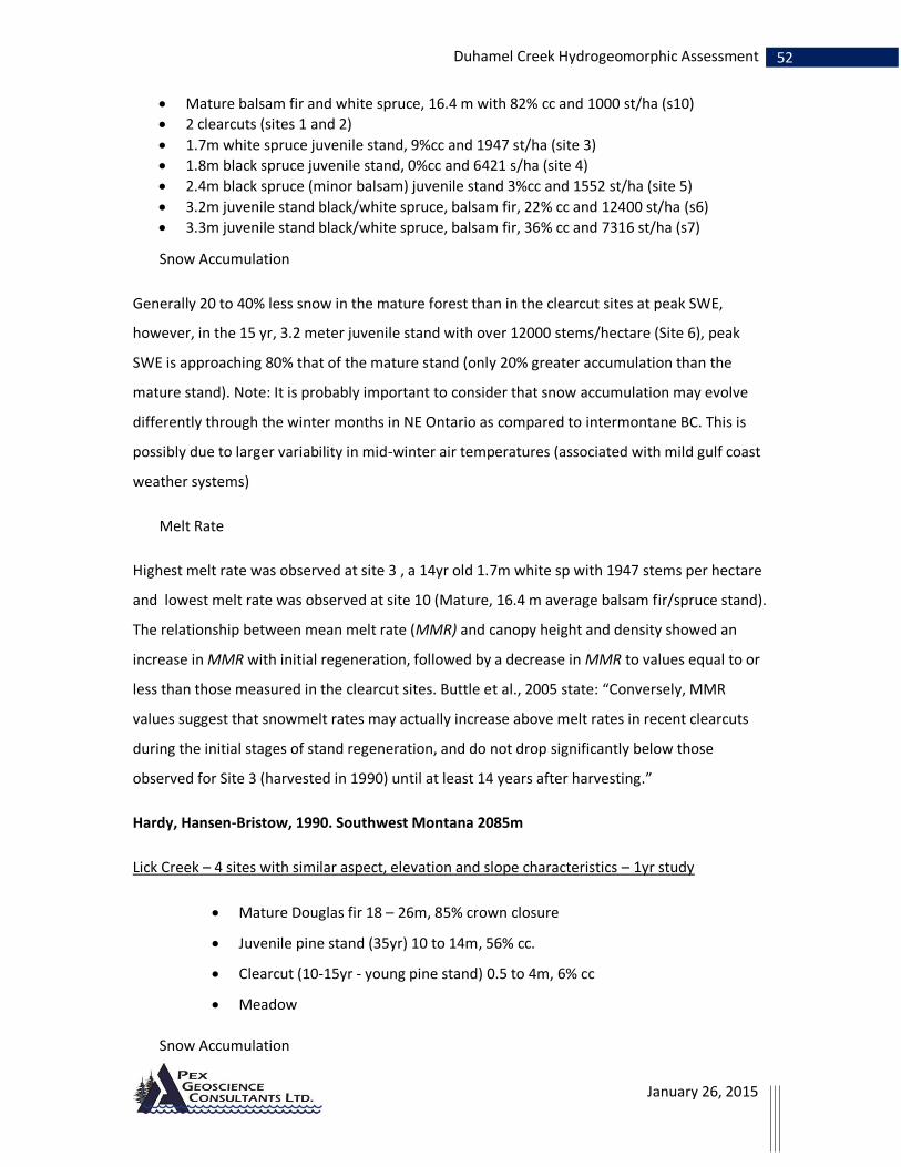
52 Duhamel Creek Hydrogeomorphic Assessment
January 26, 2015
Mature balsam fir and white spruce, 16.4 m with 82% cc and 1000 st/ha (s10)
2 clearcuts (sites 1 and 2)
1.7m white spruce juvenile stand, 9%cc and 1947 st/ha (site 3)
1.8m black spruce juvenile stand, 0%cc and 6421 s/ha (site 4)
2.4m black spruce (minor balsam) juvenile stand 3%cc and 1552 st/ha (site 5)
3.2m juvenile stand black/white spruce, balsam fir, 22% cc and 12400 st/ha (s6)
3.3m juvenile stand black/white spruce, balsam fir, 36% cc and 7316 st/ha (s7)
Snow Accumulation
Generally 20 to 40% less snow in the mature forest than in the clearcut sites at peak SWE,
however, in the 15 yr, 3.2 meter juvenile stand with over 12000 stems/hectare (Site 6), peak
SWE is approaching 80% that of the mature stand (only 20% greater accumulation than the
mature stand). Note: It is probably important to consider that snow accumulation may evolve
differently through the winter months in NE Ontario as compared to intermontane BC. This is
possibly due to larger variability in mid-winter air temperatures (associated with mild gulf coast
weather systems)
Melt Rate
Highest melt rate was observed at site 3 , a 14yr old 1.7m white sp with 1947 stems per hectare
and lowest melt rate was observed at site 10 (Mature, 16.4 m average balsam fir/spruce stand).
The relationship between mean melt rate (MMR) and canopy height and density showed an
increase in MMR with initial regeneration, followed by a decrease in MMR to values equal to or
less than those measured in the clearcut sites. Buttle et al., 2005 state: “Conversely, MMR
values suggest that snowmelt rates may actually increase above melt rates in recent clearcuts
during the initial stages of stand regeneration, and do not drop significantly below those
observed for Site 3 (harvested in 1990) until at least 14 years after harvesting.”
Hardy, Hansen-Bristow, 1990. Southwest Montana 2085m
Lick Creek – 4 sites with similar aspect, elevation and slope characteristics – 1yr study
Mature Douglas fir 18 – 26m, 85% crown closure
Juvenile pine stand (35yr) 10 to 14m, 56% cc.
Clearcut (10-15yr - young pine stand) 0.5 to 4m, 6% cc
Meadow
Snow Accumulation

53 Duhamel Creek Hydrogeomorphic Assessment
January 26, 2015
Of the four sites the meadow accumulated the most snow and the mature forest accumulated
the least. There is no significant difference in snow accumulation between the meadow and the
young pine (clearcut) stand. The juvenile stand had roughly 12% less SWE at max SWE than the
meadow and the mature stand accumulated roughly 26% less SWE than the meadow. They
suggest that there is very little change in peak SWE relative to the meadow in stands with
canopy closure between 0 and 55%.
Melt Rate
Melt rate was highest in the meadow early in the melt season. The young and juvenile stands
prolonged the melt but the average melt rate in the young (clearcut) was not significantly
different than the meadow. The avg. melt rate in the juvenile stand was roughly 38% faster than
the forest. They suggest that there is a gradual change in melt rate until the canopy density
reaches 70 to 75% of the mature stand.
Bewley et al., 2010 - plots on level ground at 990 and 1220 m
Baker Creek west of Quesnel
All plots on level ground (avg 3o gradient) at either 990 or 1220 m Baker Creek west of Quesnel
2 Juvenile pine stands (25-50yr), 10-15m, 1700 – 2900 st/ha (green/red attack)
1 Juvenile pine (10-25yr), 1-5m, 2000 st/ha.
2 Clearcuts
Snow Accumulation
No significant difference in total SWE accumulation between sites at 990m elevation. Sites at
1220 meters showed some differences with the clearcut accumulating more SWE (175mm) than
the forest (~157mm) or approximately 12% more SWE.
Melt Rate
The avg melt rate in the clearcut was significantly higher than the melt rate in the forest at 990
metres but not significantly higher than the melt rate in the (1-5m) regen stand at 990m. The
average melt rate in the clearcut is higher than that of the forest at 1220 meters but the
difference is not as great as at the lower elevations.

54 Duhamel Creek Hydrogeomorphic Assessment
January 26, 2015
Ellis et al., 2010 – Plots on north versus south aspect in Marmot Creek Alberta
This study did not include an investigation of recovery in juvenile stands but does highlight the
differences in snow accumulation and melt dynamics between north-aspect, south-aspect and
flat ground clearcut/forest pairs. This investigation found that slope aspect plays a key role in
determining differences in accumulation and melt dynamics. It follows that recovery of snow
accumulation and melt processes will vary considerably depending on the slope aspect/gradient.
Summary of Snow Accumulation and Melt data from snowmelt dominated regions
Much more research is needed to fully understand the combined effects of watershed
physiography and stand composition on the recovery of snow accumulation and melt in the
Kootenay region. Most of the studies summarized above suggest that maximum snow
accumulation begins to decrease in the young blocks (~15 yrs) relative to the clearcut but that
there is no significant decrease in the rate of melt in these young stands relative to the
clearcuts. Most studies found that more snow accumulates in the young regenerating stands
relative to the forest and the melt rate varies from slightly slower to slightly faster than the
clearcut. In terms of ‘hydrological recovery’ these young stands (that ranged in height from 1 to
6.4m depending on the study) are not showing significant recovery relative to the unharvested
stands. An exception to this was observed by Buttle et al. (2005) that documented a much lower
melt rate in the 3.3 meter regen stand that had a stem density of over 12000 st/ha.
Most studies agree that recovery of melt rate is dependent on an increase in crown closure
(crown density). Hardy and Hansen-Bristow report recovery of melt rate relative to the forest of
roughly 40% in a 35yr 10-14m (12m avg) juvenile stand. Canopy density of this juvenile stand
had recovered to approximately 65% of the unharvested forest.
Conclusions interpreted from these studies:
Up to approximately 6 meters and less than 30% crown closure hydrological recovery is
essentially 0%. Beyond 7 meters hydrological recovery increases gradually and depends on stem
density. Once stand height exceeds roughly 12 meters and crown closure exceeds roughly 60%
of the unharvested forest the stand is somewhere around 40% recovered. The rate of recovery
likely increases slightly beyond this point as crown closure increases in the maturing stand. Once
crown closure reaches roughly 75 to 80% or more of the unharvested stand hydrological

55 Duhamel Creek Hydrogeomorphic Assessment
January 26, 2015
recovery begins to approach 100%. Hardy and Hansen-Bristow suggest that complete
hydrological recovery does not occur in the mixed species stands of southwestern Montana until
upwards of 80 years. Regenerating stands of between 10 and 20 years old in central BC and
northern Ontario show very minimal to no recovery, which is consistent with the Montana
findings.
A conservative hydrological recovery curve for flat ground blocks based on the summarized
studies and adapted for southeastern BC might take the form of the following curve:
Height m % recov.
0 0 1 0 2 0 3 -5 4 -7 5 -5 6 0 7 5 10 20 13 40 15 60 18 80 20 90 Additional Notes:
While this graph shows hydrological recovery by height in meters - it is probably more
accurate to represent height as a percentage of the height of the unharvested stand
rather than an absolute value.
Crown closure (or canopy density) is an important factor in hydrological recovery. Studies
suggest that crown closure must reach upwards of 30% (absolute) or 50% of the
unharvested stand before recovery of melt rate begins. Regenerating stand with low
basal area relative to the forest will take longer to recover. Stands with higher basal area
will probably recover faster.
This curve is likely to be substantially different for blocks with north, south, east and west
aspects. Much more research is necessary to understand the effect of slope aspect on
recovery
This conservative hypothetical curve dips into the negative recovery in the earliest stage of
stand regeneration due to the increase in longwave radiation emitted to the snowpack
associated with exposed stems of the new trees. The curve as drawn is predicated on the

56 Duhamel Creek Hydrogeomorphic Assessment
January 26, 2015
recovery of canopy density as well as crown height. Lower canopy density (relative to the forest)
will shift the curve to the right (slower recovery) and substantially higher canopy density (at
least 2 times) may shift the curve to the left.
Literature cited:
Bewley, D., Alila, Y and A. Varhola, 2010. Variability of snow water equivalent and snow energetics across a large catchment subject to Mountain Pine Beetle infestation and rapid salvage logging. Journal of Hydrology, 388: 464-479.
Buttle, J.M., C.J. Oswald, and D.T. Woods. 2005. Hydrologic recovery of snow accumulation and melt following harvesting in northeastern Ontario. In Proceedings of the 62nd Annual Eastern Snow Conference, June 7–10, 2005, Waterloo, Ont., pp. 83–91.
Ellis, C.R., Pomeroy, J.W., Essery, R.L.H., and Link, T.E., 2010. Effects of needle-leaf forest cover on radiation and snowmelt dynamics in the Canadian Rocky Mountains, Canadian Journal of Forest Research, 41, 608–620, doi:10.1139/X10-227.
Hardy, J.P. and K.J. Hansen-Bristow, 1990. Temporal accumulation and ablation patterns in forests representing various stages of growth. In: Proceedings of the 58th Annual Western Snow Conference, April 1990, Sacramento, California.
Winkler RD, Spittlehouse DL, and DL, Golding, 2005. Measured differences in snow accumulation and melt among clearcut, juvenile, and mature forests in southern British Columbia. Hydrological Processes 19: 51–62.
57 Duhamel Creek Hydrogeomorphic Assessment
January 26, 2015
Appendix 3 - Climate Change, Flood Frequency in Duhamel Creek and implications for Forest Harvesting.
A statistical test for a trend over time in the Duhamel peak flow time series showed that for the
20 years of gauging there are no significant trends with time. An analysis of three near-by long-
term hydrometric stations (Kaslo River, Five-Mile Creek and Anderson Creek) was undertaken to
determine if there were any consistent trends in the regional historical hydrometric data that
can be used to determine possible future changes to the frequency of flood events in Duhamel
Creek. The analysis determined that the historical discharge data for the three near-by streams
display no consistent trends over time or changes in the mean or variability of annual peak
discharge over the period of gauging (31 years to 56 years).
Recent publications by the Pacific Climate Impacts Consortium at the University of Victoria
report the results of projected changes in a number of hydroclimate variables within the
southern BC Columbia Basin based on the application of the Variable Infiltration Capacity Model.
(Hamlet et al., 2012). The PCIC study found that;
“Of all the metrics evaluated, hydrologic extremes, and particularly high flow extremes,
showed the greatest inconsistencies between modeling approaches. Substantial differences
were also found in the percent changes in cool and warm‐season streamflow, and changes
in the timing of peak flows...”
The PCIC modeling study projects that by 2050 in the Southern Kootenay region, summer
months will experience higher temperatures on average while winter months will experience
increased precipitation on average. The PCIC group suggests that for alpine-dominated
watershed such as Duhamel Creek increased precipitation could result in increased winter snow
packs, while increased spring and summer temperatures could result in a shift to earlier peak
flows. However, it is not clear how these changes will affect the magnitude or frequency of
larger-than-average (i.e. extreme) flood events. It is possible that there will be an increase in the
number of rain-on-snow peak events compared to solar radiation driven peaks particularly
during the fall, late winter and early spring months.

58 Duhamel Creek Hydrogeomorphic Assessment
January 26, 2015
The historical hydrometric data analysis from the Kalso River, which, like Duhamel is primarily
high elevation alpine-dominated, determined that both the mean and variability of the annual
maximum peak flows have decreased in the last 25 years compared to the first 25 years of
gauging. In the Kalso River the decrease in the mean and variability of the annual maximum
flood time series over the last 50 years means that peak flows overall have decreased and the
cumulative frequency curve has become flatter. This observed change in the frequency
distribution of floods runs somewhat contrary to those based on projections of the climate
models which suggest that peak flow variability should increase (the frequency curve should get
steeper) with increasing spring temperatures and increasing winter precipitation (Pike et al.,
2010).
The following excerpt is from APEGBC document Professional Practice Guidelines – Legislated
Flood Assessments in a Changing Climate in BC (APEGBC, 2012).
“Projections of future climate or runoff are best assessed in terms of the mean and range of
outputs from an ensemble of model runs. Such results must be obtained from climatologists
who specialize in model analysis, from the sources listed in section 3.6.2 or from specialized
consultants. In the absence of applicable hydroclimate model results, magnitude-frequency
analyses based on recent experience (approximately 30 years) may remain valid for short-
term (<30 years) projections, provided no trend is evident in the historical sequence of flood
flows.”
The following excerpt is from the Columbia Basin Trust website (Water and Climate Change in
the Canadian Columbia Basin, CBT website publication download October 2014)
“…cold winter temperatures will protect mountain snowpack from warming and capture water
from wetter winters. Some high-elevation areas may even see increasing snowpack due to cold
winter temperatures and increasing precipitation. “
For the purpose of the Duhamel Creek Hydrogeomorphic Risk analysis the projected change in
climate is deemed unlikely to have a substantial influence on the existing flood frequency curve
for Duhamel Creek and therefore will not influence the outcomes of the risk analysis. However,
the projected increase in frequency of rain-on-snow events during fall, winter and early spring
months could result in increased hillslope runoff on the lower elevation slopes of Duhamel
Creek.

59 Duhamel Creek Hydrogeomorphic Assessment
January 26, 2015
Some selected literature concerning climate change projections in the Columbia Basin:
Hamlet, A., M. Schnorbus, A. Werner, M. Stumbaugh, and I. Tohver. (2012). A Climate Change Scenario Intercomparison Study for the Canadian Columbia River Basin. Prepared for the Columbia Basin Trust
Murdock, T.Q. and A.T. Werner, 2011: Canadian Columbia Basin Climate Trends and Projections: 2007- 2010 Update. Pacific Climate Impacts Consortium, University of Victoria, Victoria, BC, 43 pp.
Murdock, T.Q., S.R. Sobie, 2013: Climate Extremes in the Canadian Columbia Basin: A Preliminary Assessment. Pacific Climate Impacts Consortium, University of Victoria, Victoria, BC, 52 pp.
Pike, R. G., K. E. R. Bennett, T.E., A. T. S. Werner, D.L., R. D. M. Moore, T.Q., J. S. Beckers, B.D.,, K. D. F. Bladon, V.N., and D. A. T. Campbell, P.J., 2010: Climate Change Effects on Watershed Processes in British Columbia, Chapter 19. Compendium of forest hydrology and geomorphology in British Columbia, R. G. Pike, T. E. Redding, R. D. Moore, R. D. Winkler, and K. D. Bladon, Eds., BC Ministry of Forests and Range with FORREX Forum for Research and Extension in Natural Resources, 699-747.

60 Duhamel Creek Hydrogeomorphic Assessment Appendix 4. Field form data from 2013 and 2014 surveys
January 26, 2015
Survey
Site
Site
ID Time
Wb(m
)
Dbf(
m)
D90(cm)
1
D90(cm)
2
D90(cm)
3
D90(cm)
4
D90(cm)
5 Avg S%
Morph
ology Description
Lwd Functi
on
Lwd (#/1
0m) Riparian
1
Site#0
1
Aug 6, 2014, 9:57
AM 6.1 0.39 32 22 27 25 25 26 27 Ca(b)
Confined boulder bedrock cascade.
Bottom edge of woody debris deposit from snow avalanches. Most recent woody deposit is several years old but
also there is wood from old deposits. Width and depth here is appx avg flood. D90s from 3/4 yr old flood/
slush avalanche.
// Margin
s 10
Cleared by avalanches to about 3 m. Above is maple and sapling
hemlock
2 Site#02
Aug 6, 2014,
10:28 AM 0 0 0 0 0 0 0
0 Brk Top of wood deposit
-None
Selected- 0 N/A
3 Site#03
Aug 6, 2014,
12:24 PM 4.6 0.34 4.5 4.5 4 4.2 5 4.4 2.5
Plane Bed
Angular cv from valley side. Material in bed >48mm is mossy and angular. No function lwd here. Banks are veg
with willow and grasses and moss. Wolman done here.
-None
Selected- 0
Mixed age hemlock to 40 cm
4 Site#04 N/A 0 0 12 13 14 16 13 14 2
Plane Bed
Deposit of SWD along channel margins from 5yr flood deposit appx
-None Selected- 0 N/A
5 Site#05
Aug 6, 2014, 1:05 PM 0 0 2.1 2.3 1.2 2 1.5 1.8 0.5 FRp Pools above old broken beaver dam
-None Selected- 0 N/A
6 Site#06
Aug 6, 2014,
1:36 PM 5.2 0.55 9 16 14 12 13 13 4 FSp
Channel confined both sides. Cv from deposits both sides is in channel
mossy and angular. Forming stepped morph. Partly 0.5
Mixed age hemlock
and cedar. Some starting to go down across channel. Still list
if v old wd from logging along margins.
7 Site#07
Aug 6, 2014, 1:48 PM 5.1 0.47 19 20 27 24 19 22 3 Sp
Confined as at last Stn. Lots of mossy cv in channel. Some steps forming. V
old lwd along margins here from 20+ yr flood. Also branches from more e Recent 2 to 5 yr flood. Wolman done here
// Margins 1 As at last
5.15 0.51
17 3.5
9 Site#09
Aug 6,
2014, 2:38 PM 0 0 0 0 0 0 0
0
-None Selected- Beaver pond
-None Selected- 0 N/A
10 Site#10
Aug 6,
2014, 3:02 PM 6.8 0.3 19 22 17 19 22 20 2 FRp
Below bridge cobble load. Channel is
unconfined over 30 m wide floodplain. Cobbles from debris flow channel. Recent flood deposit branches.
-None Selected- 0 Willow
11 Site#11
Aug 6, 2014, 3:16 0 0 6 5 7 7 10 7 0 Rp
Unconfined channel near toe of old debris flow deposit .
-None Selected- 0 N/A

January 26, 2015
61 Duhamel Creek Hydrogeomorphic Assessment
PM
12 Site#12
Aug 6, 2014,
3:29 PM 6.5 0.37 20 19 22 20 17 20 4 Mixed
Above debris flow trib. Below beaver dams. Wolman done. Channel is
colluvial angular boulders with sand gravel matrix. Dark mossy cv.
-None
Selected- 0 Willow
13 Site#13
Aug 7,
2014, 9:36 AM 2.4 0.18
23 21 28 26 25 23 Cv
Debris flow trib. Some recent flood
activity within past 10 yrs. bed material is boulders to 25 cm. broken wd in channel under recent deposit.
Boulder levees on fan are pre this stand so 100 to 200 yrs. cedar to 80 cm on levees. Partly 0 N/A
14
Site#1
4
Aug 7, 2014, 10:07
AM 12.7 0.8 19 23 24 25 23 23 14 Ca(b)
Cv boulder cascade. Confined both banks by cv deposits and some brk. Sand gravel matrix to bed. Cv blocks
mossy and immobile.
// Margin
s 1
Mixed age cd hem to 60cm. V old broken wd // to banks. Some
smaller wd starting to enter from riparian. Lots of broken wood
along channel.
15 Site#15
Aug 7,
2014, 10:28 AM 6.1 0.76 17 19 20 21 19 19 5 Mixed
Cv cascade to sp. starting to see steps forming with small boulders.
Channel confined both sides. Sand gravel matrix. Cv boulders to 1 m. Wolman done here.
// Margins 1
Avalanche cone on r bank. Mixed cd hm to 60 cm on left.
16 Site#16
Aug 7, 2014,
10:59 AM 9.3 0.54 5 4 5 7 8 5.8 11 Ca(b)
Cv boulder cascade with sand gravel
matrix. Confined both sides by cv deposits. Cv boulders mossy. Branches against wd jam from recent
flood 2/3 years. Lwd jam here is 2 to 4 decades old. Partly 1
Mixed cedar hem to 1 m. Some across
channel. V old broken lwd // to banks.
17 Site#17
Aug 7,
2014, 11:24 AM 0 0 0 0 0 0 0
45 Cv Last large flood about 40+_ 20 years. But not debris flow. Partly 0 Mixed cedar hemlock
18 Site#18
Aug 7, 2014,
11:59 AM 4.1 0.44 26 27 25 22 27 25 14 Ca(b)
Last flood 2 yrs ago. Scoured forest floor and sand to cobble material deposited overbank. Last debris flow
about 20 years ago now has sapling hemlock to 3 m height on levee. Also boulder deposits from 10 to 20 years
with moss and hebaceous. Banks are scoured to eroded from recent flood. Partly 1
Mixed cedar hem to 50 cm. some wood suspended across
channel recently 40 yrs.
19 Site#19
Aug 7,
2014, 12:14 PM 4.6 0.45 31 30 30 32 31 31 16 Ca(b) Boulder cascade.
// Margins 0.5 N/A
4.35
0.445
28 15

January 26, 2015
62 Duhamel Creek Hydrogeomorphic Assessment
20 Site#20
Aug 7, 2014,
1:12 PM 0 0 0 0 0 0 0
0 Sp Wolman done here
-None
Selected- 0 N/A
21 Site#21
Aug 7,
2014, 2:22 PM 9.8 0.64 52 50 60 60 52 55 6 Sp
Boulder step pool to cascade. Confined on l by bedrock. Entrenched on r by old levee by 1 m. Partly 0.5
Cedar hemlock to 40
cm. banks are vertical and veg with moss. Recently scoured.
Banks are boulder deposits. Cedar to 30 cm growing in deposits.
22
Site#2
2
Aug 7, 2014, 3:26
PM 8.8 0.68 38 39 30 36 34 35 6 Sp
Boulder step. Banks are boulder deposits vegetated with willow.
Channel entrenched 1 to 2'meters.
-None Select
ed- 0 N/A
23
Site#2
3 N/A 0 0 0 0 0 0 0
0 Sp Same as last
-None Select
ed- 0 N/A
marked as 021
Site#26 N/A 0 0 0 0 0 0 0
0 Sp
Upstream in cobble boulder step. Boulders are sub angular and dark. Sand in matrix of channel
-None Selected- 0 N/A
marked as
022
Site#2
7 N/A 0 0 0 0 0 0 0
0
-None Select
ed-
Cv slope on east side supplying angular cobbles and boulders to
channel
-None Select
ed- 0 N/A
October 17, 2013 survey data
Survey
site
Time
Wb(m
)
Dbf(
m)
D90(cm)
1
D90(cm)
2
D90(cm)
3
D90(cm)
4
D90(cm)
5
Ave
rge S%
Morph
ology Description
Lwd Functi
on
Lwd
Density (#/1
0m) Riparian
001
N/A 0.00 0 0 0 0 0 0
0
-None Select
ed- N/A
-None Select
ed- 0 N/A
002
N/A 9.00 0.75 60 65 58 75 85 69 11 Sp
Boulder step pool to cascade. Banks overhanging and veg with cedar hem.
Evidence of recent overbank flood. Sand deposits downstream from large step boulders.
-None Selected- 0 N/A
003
N/A 0.00 0 0 0 0 0 0
8 Sp As at site 2
-None Selected- 0 N/A
004
N/A 0.00 0 0 0 0 0 0
0
-None Selected- Pictures up and down stream
-None Selected- 0 N/A
005
N/A 9.50 0.9 0 0 0 0 0
7 Sp
Old flood deposit along margin appx 10 years. Broken lwd. Bed load
moved appx 20 m downstream.
-None Select
ed- 0 N/A

January 26, 2015
63 Duhamel Creek Hydrogeomorphic Assessment
006
N/A 0.00 0 0 0 0 0 0
0 Ca(b)
Bank slough and avulsion of channel.
Trib enters from west here. Boulder step to cascade morph.
-None
Selected- 0 N/A
007
N/A 10.00 0.6 65 70 75 60 80 70 8 Ca(b)
Above debris flow trib. Channel is still
bimodal with sand but much less cobbles. Now bed has mossy boulders. Picture taken looking
upstream from high bank. Upstream from 07. Pic of empty lwd jam due to lack of cobbles.
-None Selected- 0 N/A
Average 9.50 0.75 69 8.50
008
N/A 8.80 0.8 70 0 0 0 0
6 Sp
Mossy boulder step pool to cascade.
Stone lines very mossy. Bank scour less apparent but still present.
-None
Selected- 0 N/A
009
N/A 0.00 0 0 0 0 0 0
0
-None
Selected-
Old very large LWD jam. Possibly old bridge site.
-None
Selected- 0 N/A
010
N/A 0.00 0 0 0 0 0 0.4
4
-None
Selected-
20 m long sand wedge above old LWD jam. Cobbles are mossy but gravel to 2 cm is bright. Appx. Recent
erosion to 50 cm of lateral deposit of sand and organic.
-None
Selected- 0 N/A
011
N/A 0.00 0 0 0 0 0 8
1 Rp Broken beaver dam at outlet of wetland.
-None
Selected- 0 N/A
012
N/A 0.00 0 7 5 6 7 8 6.6 0 Rp
Upper end of wetland. Beaver dams
recently broken .. Maybe 2 yrs ago. Channel bed has lots of moss.
-None
Selected- 0 N/A
013
Oct 17,
2013, 2:01 PM 8.60 0.5 5 0 0 0 0
2 Plane Bed
Banks veg with mixed age cedar hemlock. Vertical and mossy. No obvious scour here.
-None Selected- 0 N/A
014
N/A 0.00 0 0 0 0 0 0
20 Cv Fan of debris flow trib. Over 100 m in length
-None Selected- 0 N/A
015
N/A 7.50 0.6 0.5 0 0 0 0
6 Sp
Looking downstream at old LWD jam
and upstream at step pool channel with stonelines of angular boulders. Channel is entrenched/confined by
bedrock and fan on west. Channel has sand matrix around cv boulders.
-None
Selected- 0 N/A
016
N/A 0.00 0 0 0 0 0 0
0 Sp
Old debris jam. Channel has avulsed and has multi thread morphology over
40 m wide valley flat. Bed contains quite a lot of angular cobbles as well as subrounded mossy cobbles and
boulders. Sand accumulated behind part func lwd. Partly 0 N/A

January 26, 2015
64 Duhamel Creek Hydrogeomorphic Assessment
017
N/A 0.00 0 0 0 0 0 0
0 Rp Upstream from 16. Pics up and down. Up is cobble riffle channel
-None
Selected- 0 N/A
018
N/A 10.10 0.6 10 0 0 0 0
0.5 Rp
Meandering riffle pool with sand and
gravel unconfined over appx. 50 m flat. Banks veg with willows and grass.
-None
Selected- 0 N/A
019
N/A 0.00 0 0 0 0 0 10
2 Rp
Still riffle pool with sand and gravel. Elevated sand bar picture. Grasses and shrubs established suggest it is
from 10 yr appx flood. Banks vertical and mossy.
-None
Selected- 0 N/A
020
N/A 8.00 0 0 0 0 0 20
4 Rp
Lwd jam in riffle pool multi branch reach. With cobble sand wedge upstream.
-None Selected- 0 N/A
021
8.00 0.6
15
3
022
18-Oct-13
Survey site
Site ID Time
Wb(m)
Dbf(m)
D90(
cm)1
D90(
cm)2
D90(
cm)3
D90(
cm)4
D90(
cm)5
S%
Morphology Description
Lwd
Function
Lwd Density
(#/10m) Riparian
023 Site#25 N/A 0 0 0 0 0 0 5
0.5 Rp
Low gradient sand wetland. Channel
is mostly gravel and sand. Evidence of large flood appx 2 yrs is seen as scour along banks. Otherwise banks
are overhanging with willows and grasses. Bedrock on both sides of wetland.
-None Selected- 0 N/A
024 Suthld42 N/A 8.2 0.5 15 0 0 0 0
3 Sp
Top of wetland reach into bedrock
confined step pool with large cv. Sand and cobble bars along margins are recent appx 2 yrs.
-None Selected- 0 N/A
025 Suthld42 N/A 0 0 0 0 0 0 0
0 Rp
Above sp reach. Gradient drops due to v old wd pile 50 yrs or more. Channel now meandering rp with
mossy bed. Picture of recent avalanche wood in channel.
-None
Selected- 0 N/A
026 Suthld42 N/A 0 0 0 0 0 0 0
0 Rp
Channel becomes multi branched over 50 m wide flat due to old wd piles. Pictures taken in panorama.
-None Selected- 0 N/A
027 Suthld42 N/A 0 0 0 0 0 0 0
0
-None Selected-
Old slide appx 20 to 30 yrs. woody
debris and culvert from slide appx 10 to 20 m downstream also cobble boulder bar deposit.
-None Selected- 0 N/A

January 26, 2015
65 Duhamel Creek Hydrogeomorphic Assessment
028
Suthld
42 N/A 8.4 0.4 25 0 0 0 0
5 Ca(b)
Lots of mossy cv creating cascade channel with sand matrix. This stn is appx 40 m downstream from recent
avalanch path appx 20 yrs. cv cone of avalanche with lots of blocky cv. This is source of cv in channel... Long term
process.
-None Select
ed- 0 N/A
8.3 0.45 20
4
029 Suthld42 N/A 0 0 0 0 0 0 10
4 Ca(b)
Just downstram from recent
avalanche path. Lwd jam with 12 m long sand and gravel wedge. Lots of mossy cv in channel.
-None Selected- 0 N/A
030 Suthld42 N/A 9.4 0.3 0 0 0 0 15
2 Rp Just below 2012 slide
-None Selected- 0 N/A
031
Suthld
42 N/A 0 0 0 0 0 0 0
0
-None Select
ed- 2012 slide site
-None Select
ed- 0 N/A
032 Suthld42 N/A 0 0 0 0 0 0 0
0
-None
Selected- Apex of slide deposit
-None
Selected- 0 N/A
033 Suthld42 N/A 9.1 0.45 20 0 0 0 0.15
4 Ca(b)
Channel directly above slide. Channel has abundant mossy angular
boulders. Banks veg with red ozier dogwood.
-None
Selected- 0 N/A
034 Suthld42 N/A 9.4 0.4 20 0 0 0 0
3 Ca(b)
Cascade with cv boulders up to 1 m. Mossy and dark.
-None
Selected- 0 N/A
035 Suthld42 N/A 0 0 0 0 0 0 0
0
-None Selected- Recent scour along west bank.
-None Selected- 0 N/A
036
Suthld
42 N/A 0 0 0 0 0 0 0
0
-None Select
ed-
Very large old avalanche deopsit with
lots of cv woody debris and sand.
-None Select
ed- 0 N/A
037 Suthld42 N/A 0 0 0 0 0 0 0
12 Ca(b)
Looking upstream at cv cascade reach just below avalanche track.
-None
Selected- 0 N/A
8.775
0.4375 20
3.75