invisible to the naked eye · invisible to the naked eye john snow cleanliness .and an early...
TRANSCRIPT

Invisible to the Naked Eye
John Snow
Cleanliness . . . and an early application of medicine and medical skill . . . were supposed to be specifics against the contagion. And to a certain extent there is some truth in these views; and i t is thus that God enforces on us, by his great and invariable laws of health, the necessity of attention to these sanitary measures. But, pushing that truth too fix, men began to map out the geographical bound- aries of the malady. . . . Then the selfishness of our nature, leaving the poor in their disease or in their danger to pay the penalty of their localities, was heard to congratulate itself on the comparative safety of its better situations. . . . And then it was . . . that the cholera at one leap passed from the squalid abodes of poverty into the houses which were re.joicing in their comforts, and the streets which were high and clean.
-Rev. Henry Venn Elliott, "Two Sermons on the Hundred and First and Sixty-Second Psalms as
Applicable to the Harvest, the Cholera, and the War"
SNOW AND THE MEDICAL MODEL
PHYSICIAN BENJAMIN WARD RICHARDSON, describing public reaction to the St. James epidemic, remarks, "[Sluch a panic possibly never existed in London since the days of the great plague. People fled from their homes as from instant death, leaving behind them, in their haste, all that they valued most" (mi ) . John Snow's analysis of this epidemic and recommendation to remove

56 Mapping Disease in the Metropole
the Broad Street pump handle are always prominently featured in medical histories of the period. Histories of medical maps hold up Snow's map of the Broad Street epidemic as the most important development in medical map- ping of its era. Despite the dominant sanitary paradigm, Snow positioned himself against the sanitarians. In 1855, he gave evidence before the Select Committee, expressing his conviction that "he was no defender of nuisances, but . . . a bad smell cannot, simply because it is a bad smell, give rise to a spe- cific disease" and that specific diseases were the result of specific disease agents (Richardson xxix).
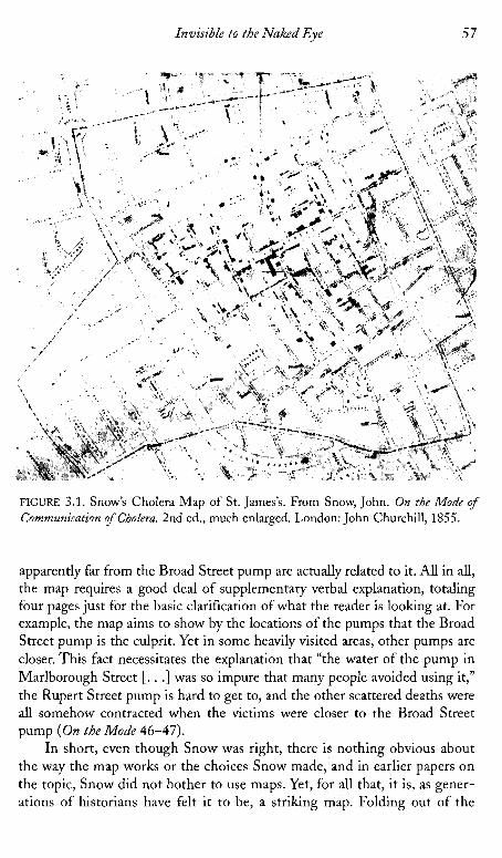
Snow's famous second edition of On the Mode o f Communication o f Cholera begins with an argument for human transmission of the disease and a history of its movement across Asia and Europe from the Ganges. A substan- tial portion tracing epidemics in several other areas of London and the United Kingdom generally consists of verbal mapping, with place names and dates, but does not include cartographic representation. The first map is of the St. James outbreak (see fig. 3.1). This is of course the primary topic of the paper and the most impressive to the public not only because of the concentration of deaths there, but because of the fame of the parish as the location of court and metonym for aristocratic wealth of the metropolis, as we will see in chap- ter 4. Interestingly, it contains no dates, although using dates to show spread was a widespread practice in epidemic mapping. (Snow includes dates and numbers of deaths in a separate table.) Snow states that most deaths took place very close to the pump, but then mentions some which took place fur- ther away, in consequence of exposure to the pump water, or those deaths which resulted from exposure in Broad Street, but took place in the country as a result of householders fleeing the city. Snow does not choose to show a larger map with lines connecting such victims to Broad Street, which would provide more complete evidence but lessen the visual impact of the map. He defines the "cholera field" in the following way:
The dotted line on the map surrounds the sub-districts of Golden Square, St. James's, and Benvick Street, St James's, together with the adjoining por- tion of the subdistrict of St. Anne, Soho, extending from Wardour Street to Dean St., and a small part of the sub-district of St James's Square enclosed by Marylebone Street, Titchfield Street, Great Windmill Street and Brewer Street. All the deaths from cholera which were registered in the six weeks from 19th August to 30th September within this locality, as well as those persons removed into Middlesex Hospital, are shown in the map by a black line in the situation of the house in which it occurred or in which the fatal attack was contracted. (46)
Additionally, Snow shows the locations of all pumps and adds explana- tions for why some pumps were less used than others, and why some deaths
Invisible to the Naked Eye 57
FIGURE 3.1. Snow's Cholera Map of St. James's. From Snow, John. On the Mode of Communiration ofCholera. 2nd ed., much enlarged. London: John Churchill, 1855.
apparently far from the Broad Street pump are actually related to it. All in all, the map requires a good deal of supplementary verbal explanation, totaling four pages just for the basic clarification of what the reader is looking at. For example, the map aims to show by the locations of the pumps that the Broad Street pump is the culprit. Yet in some heavily visited areas, other pumps are closer. This fact necessitates the explanation that "the water of the pump in Marlborough Street [. . .] was so impure that many people avoided using it," the Rupert Street pump is hard to get to, and the other scattered deaths were all somehow contracted when the victims were closer to the Broad Street pump ( O n the Mode 46-47).
In short, even though Snow was right, there is nothing obvious about the way the map works or the choices Snow made, and in earlier papers on the topic, Snow did not bother to use maps. Yet, for all that, it is, as gener- ations of historians have felt it to be, a striking map. Folding out of the

5 8 Mapping Disease in the Metropole
report at a scale of thirty inches to the mile, the map marks death houses with coffin shaped black bars. Where there are several, the results, in a sim- ple black and white line map, are eye catching. And certainly there is a grouping around the Broad Street pump. Still, had a map reader been moti- vated to find fault, there would be plenty here to undercut Snow's thesis- it is in the text that the objections the map might raise are nullified. I t is too often forgotten that this argument was initially widely refuted-by the investigators reporting to the Privy Council, for example-and that Snow did not use the map to convince the guardians to remove the pump handle, but created it long after the fact. Nor did he use it to discover the relation- ship between water and cholera, a theory he had been working on for some time and had already published in 1849.
W h a t the map does do, and what all disease maps of this period do to some extent, is to redefine a space, usually an urban space, by the relation- ship of a certain human experience-vulnerability to disease-in relation to some hidden or at least nonobvious feature of the landscape. In this way, maps were very like anatomy "atlases" or pathology texts-they laid bare the invisible relationships between seemingly different things that only the doc- tor/scientists gaze could discern. In Snow's case, it was water and its flow and the human activities around water that defined a "field" or disease com- munity. The community is demarcated by what we might phrase as the "fur- thest reach of the disease within a convenient representational arean-in other words, it does not include the cases in the country or in hospitals in another parish. Snow is concerned with origin, and the map is created to argue for that origin. Further, it does not extend to other communities in London that suffered in the 1854-1855 epidemic. Snow maps only the deaths he feels he can trace to the pump. his is essential for his argument, and may also rhetorically play to the perceptions of the residents who, as we shall see, distinguished their epidemic from that of the rabble elsewhere, though Snow pays extensive attention to other areas of London in his text. Unlike many sanitary maps, wherein communities were defined instrumen- tally by boundaries of parish authority, Snow's map of the St. James's epi- demic spills considerably over into St. Anne's Soho. Parish boundaries become less important than the itineraries-the "practice of spacev-that link the residents of an area in their use of a common water source. I n turn, the anachronic nature of the map freezes that human activity and figures it as a passive spatial relationship.
The next portion of the report doubles back to 1832 as Snow draws larger connections between water quality and disease. H e uses tables to show parish variations in mortality and connect them to water supply, first in 1832 and then in 1849 (which also correlates to house values): "A glance at the table shows that in every district to which the supply of Southwark and Vauxhall,

Invisible to the Naked Eye 5 9
or the Lambeth Water Company extends, the cholera was more fatal than in any other district whatever" ( O n the Mode 64). H e continues this examination through the most recent epidemic, using more than fourteen tables, mostly from William Farr's evidence, to illustrate various points about population, water purity, season, and so forth.
These tables are extensively discussed, and are themselves far more telling than the map which illustrates them and which Snow does not discuss at all. The map is quite beautiful, though, in three flat colors printed over a black and white map of Southwest London from west to east including Putney to the Isle of Dogs to the north, and to the south of the Thames covering Wim- bledon on the west to Sydenham on the east (see fig. 3.2). The colors include red or pink for areas served by the Lambeth Water Company, blue for South- wark and Vauxhall, and purple where the pipes are mingled. The map, obvi- ously a regular commercial map which he has had printed over, contains a good deal of extraneous information (railway lines and such). I t shows deaths with small square or rectangular spots, and makes no attempt to correlate
FIGURE 3.2. Snow's Water Map. From Snow, John. On the Mode of Communication of Cholera. 2nd ed., much enlarged. London: John Churchill, 1855.

60 Mapping Disease in the Metropole
them to structures such as pumps and so forth. This map is much less fre- quently mentioned by cartographic historians than the Broad Street map.
However, the second map is rhetorically interesting, and was fascinating to its contemporary audience, in that it shows an even less obviously visible relationship between disease and population than the first, more local map. Although Snow's maps were not important in discovering the causal relation- ships they illustrate, they were certainly important in allowing readers- guided by the expert testimony in the text-to conceptualize such relation- ships in a new way, having to do with the actions of humans in relation to the environment. Despite the startling argument which it illustrated, the map had the virtue of a certain familiarity-because sanitary theories determined moist areas to be miasmatic, the riverbanks had long been viewed with suspicion- so that there was already a context for understanding. the Thames as a threat. - Judging from the strong response to this paper, after earlier papers by Snow arguing the same theory had gone unanswered, and judging from the univer- sal use of maps in those reports either attempting to support or refute Snow, the maps had a strong suasive impact.
The water company map does offer a new definition of a human com- munity, much like the Broad Street map, a definition based on multiple fac- tors-location relative to the Thames, to particular piping, and so on, but, perhaps most importantly, as a group of consumers. United both by their access to a geographical resource and by their consumption of a certain con- sumer good, this community achieves a certain political and legal status through this definition. (The 1867 epidemic sparked parliamentary investi- gations into the water companies and epidemiological analyses of their prod- uct and its sources.) And of course, it also shows the connectedness of a large and widely dispersed group of people through their interactions with the environment. All of these allow different ways of imagining community, and encourage them-by grounding the stakes in something as fundamental as the body and survival itself. Perhaps most importantly, as we saw in chapter 2, medical maps provided doctors with a way to talk about populations in a way legitimated by that medical vision Foucault so compellingly described in Birth of the Clinic. Early on, sanitarians and public health legislators slighted doctors, in part because the doctor was perceived to have to do only with individuals and their treatment-inevitably a private affair. Epidemics, for doctors, it was thought, were just large numbers of individual cases. Medical mapping allowed doctors to talk about populations, not in the borrowed terms of sanitarians, who were concerned with what the untrained eye could easily see (or the nose could smell), but in terms uniquely their own, show- ing relationships not readily visible to the lay observer. I t provided doctors with a way of staking out p b l i c health as a medical rather than simply a management issue.

Invisible to the Naked Eye 6 1
John Snow represents a new kind of medical mapmaker, one who departed decisively from the sanitary model of miasmatic spread, and who used maps to advance a more subtle argument, based on a more clearly med- ical understanding of the body-that is, an understanding of the body based on beliefs about causation which were derived from a surgical model, allow- ing for specific disease agents. In researching his theory about the waterborne nature of the cholera, Snow himself examined many maps. Snow's several papers before the Broad Street outbreak, arguing the same theory, that is fecal-oral communication especially through contaminated water, referred to maps and reports published elsewhere, and an extensive correspondence with local medics in other cities, although, as I have said, these papers were not illustrated with maps of their own. He refers especially to the literature sur- rounding cholera in India. In 1849 for example, he speaks of his conviction of human carriage derived from the Indian literature from 1817 onward (S), and argues for the fecal-oral route, noting, "iMany of the patients attributed their illness to the water" which smelled bad (Snow, On the Mode 8-9). He also was careful to examine all the available maps on the cholera in England, including Shapter's. Like Acland, he was interested in tracing an historical and geo- graphical relationship which required the comparison of multiple documents, although, unlike Acland, his argument is not best served by encoding that longer history in the map, as he wishes to draw attention to the geography of a very particular epidemic.
Although Shapter does not show pump locations, the proximity of the concentration of deaths, and especially earlier deaths, near the river in Shap- ter's map may have been useful to Snow-although the population is also con- centrated in that same area, making the map a good candidate to support either sanitarian arguments against crowding or statistical arguments about proportional per capita distribution. Shapter does include a great deal of information in his text about the locations and availability of water sources as part of his sanitary argument. Snow corresponded with Shapter, and refers to maps of sewer locations with which Shapter provided him (Snow, On the Mode 98). He observes that Shapter mentions that in 1832, most town dwellers used river water whereas in the following epidemic, the town was well sewered and well supplied with water, and only twenty died there, the victims mostly having come from elsewhere. By the third epidemic, only one death took place in Exeter. Snow also refers to studying a map of HuU, "furnished me in 1849 by Dr. Horner of Hull" (On the Mode 101). He often mentions other works which we know contained maps, even if he does not refer specif- ically to the maps themselves; he mentions consulting various local sanitary reports, for example on Birmingham, most of.which were supplemented with maps (On the Mode), as this practice of including them in local sanitary reports became widespread from the late 1840s on. In short, Snow was working
62 Mapping Disease in the Metropole
within a context of a genre defined in part by the sanitary map and his dis- cussion shows that he is using these maps as a research tool to support and supplement his own analysis.
What Snow does not show is as important as what he does. He does not show dates, lines of spread, the locations of nuisances, drains, or sewers, as many before him had done. He also does not show geological features such as elevation or soil type, which he could certainly have done on the second map, although he mentions with interest the work of the American John Lea, who had attempted such a correlation. He ignores all of these common devices because they are not germane to the argument he wants to make-as we shall see, a response to his argument is the General Board Report, which does dis- play some of these sanitary features. In the light of such comments as Robin- son's-"Although Snow did not know what caused the cholera, the structure of the distribution of deaths as revealed by the mapping convinced him that water from a particular well was the local source" (Early Thematic Mapping 172-73)-it is important to remind ourselves that Snow's map worked as well as it did because it was a highly selective illustration of a hypothesis, not a research tool in the first instance: he had worked out his theory well in advance of the creation of this map.' But the rhetoric of this map is based on the truth claims of cartography in this period, and it is quite possible that the map came to seem less and less refutable, less and less an argument and more a representation of reality, as it became detached from the immediate context of 1855. What is important here is that for the first time, the map is clearly and consciously used to advance an argument, not with a belief that the map will transparently show the truth, but with the conviction that the truth is more persuasive represented cartographically than otherwise, and the rhetoric of the map is carefully controlled to heighten the effect of Snow's argument.
These maps offer little sense of lived space, a task which is taken up by their accompanying narrative. Shapter and Snow, for example, both provide ample explanation of why people used one water source rather than another, and how apparently anomalous deaths were to be reconciled with the existing narrative. This provides something of the sense of perceived and lived space the map lacks. We learn of the practices and preferences of the people within that environment: how the brewers were untouched because they drank only beer, how one lady sent her servants well out of their way because she pre- ferred the taste of the pump at Broad Street. But visual representations of data tended toward abstraction and homogenization, organizing their reader-cue- ing strategies by assigning equivalent values to apparently equivalent spaces and simplifying out data that complicated those representations.
In this same period, we see the increasing homogenization of vel'bal case studies and the introduction of standardized charts which simplified the col- lection and analysis of data, but tended also to structure the encounter of the

Invisible to the Naked Eye 63
patient and healthcare worker in terms of general norms rather than individ- ual experiences. Although both patients' case charts and maps emerge from the increasing importance of statistics and the Euclidean vision they depend on, it is probably not too much to hypothesize that the spatialization of indi- vidual experience in a chart may have been facilitated by a medical and social imaginary nurtured on the more intuitive visual representation of geographi- cal space and connection of individual bodies' health to that spatialized visual display. The details of lived experience and personal character that would have been so important to diagnosis a few decades earlier are now relegated to the status of secondary information. They come into the narrative primarily to explain the incursion of lived space's irrationality, which the map's implicit reliance on conceived space makes it incapable of representing-for example, the map's use of proximity to the well to mark the well's dangerousness fails confronted with some individuals' apparently irrational use of a well which is not the closest one to them. Narrative becomes a vehicle for the explanation of individual abnormality; the norm can be represented visually.
In short, although cholera maps of the time actually tell or prove very lit- tle without the accompanying text, the mere existence of the map itself could have a powerful legitimating effect. As we saw earlier, maps evoked potent claims to transparency and truth-even when the truth had to be carefully defined verball; to be visible. And, increasingly in this period, social truths were that which could be represented primarily visually, giving narrative the role of supplementing and explaining that truth.' And those who refuted Snow had to have recourse to the medium of the map to do so.
Several responses were published. The Royal College of Physicians, represented by Baly and Gull, considered Snow's theory and rejected it in their detailed analysis of the epidemic. However, their report was drawn up, apparently, before Snow's 1855 map was in print. The General Board of Health published what was probably the weightiest early response to the outbreak-and to Snow (General Board of Health, Medical Council). Their report reveals a complex local dialogue on the etiology of the disease, in which local residents drew on local history and maps and urban legend to respond to the outbreak and also to sanitary improvements which had been . underway at the time of the epidemic, as well as internecine battles between medical researchers:
We found two opinions, amongst others, prevalent throughout the neigh- bourhood; one, that the disturbance of the old burying ground was the chief cause of the outbreak of Cholera, the ravages of which, many of the inhabi- tants maintained, followed the line of the new sewer, the other, that a pump in Broad Street was at the bottom of the mischief. Neither of these causes, we believe, affords a satisfactory reason for the outbreak; both, we suspect, have been prominently put forth by interested persons, who were desirous of

64 Mapping Disease in the Metropole
diverting the current of popular indignation from their own particular nui- sances. For example, we found the owner of the monster slaughter-house in Marshd Street, and who also has an interest in the tripe-boiling establish- ment adjoining, to be one of the loudest and most eager in declaiming against the sewers . . . [but this is not borne out]. . . . As to lthe pump] . . . we are bound to say that there are some cases of disease and death which we find ourselves unable to explain upon any other hypothesis. (Fraser, Hughes, and 1,udlow 150-153)
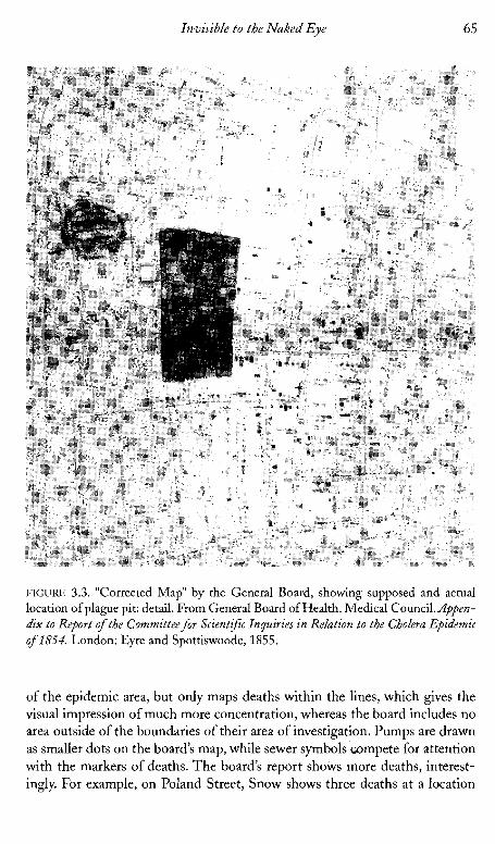
"The old burying ground" referred to a plague pit on the estate grounds on which St. James's rested-the burial ground dating back, then, to the sixteenth century. The notion that it was directly under Broad Street was based on the Commissioners of Sewers' map, a map subsequently revised by comparison to a supposedly more accurate map from the Craven estate which showed the true location of the burial ground at some distance from that spot. The author lumps in the supporters of Snow's theory with "interested persons" like the slaughterhouse owner, yet, finally, must admit that there are deaths that can- not be accounted for in other ways. A "corrected" map attached elsewhere in the report is not specifically referred to but reflects this narrative (see fig. 3.3). The map is responsive to Snow's argument and to the other rumors, showing the old sewers, the new sewer, the location of the Lord Craven estate and the "erroneous" location of the plague pit shown in the map of the Commission- ers of Sewers-which indicates that someone had gone early on to look at the Commissioner of Sewers' map in order to support the plague pit claim. The spot map is detailed, at eighty-eight feet to one inch, and shows all deaths by small rectangles, with differently oriented rectangles to show whether the vic- tim was a resident of the area or not. They also mark pumps, side entrances, ventilators, and sewer grates, distinguishing between trapped and untrapped.
Snow's pamphlet was finished on December 11, 1854, and published in 1855 (On the Mode). He refers to Scot's 1824 report, Baly, of Baly and Gull's Royal College of Physicians Report (1854), and several reports from local san- itary authorities and from India (with maps). Tt seems likely that Snow's map was completed before the General Board's. I t is likely that the authors of the board's report would have seen Snow's map before it went to press in any case, as Snow had been courteously helped with access to all information on cholera mortality at the General Registrar's Office as it came in. The General Board's map, constructed by Fraser, Ludlow, and Hughes, follows the basic plan of Snow's, though it is larger and shows more detail, including house numbers. It also covers somewhat less area, not going much east of Regent Street, whereas Snow includes material to Bond Street on the southeast portion of the map. The General Board uses the Commissioners of Sewers' map and updates it by consulting the Craven estate archives to show a "more accurateJJ location of the plague pit. Snow also includes a great deal of material outside
Invisible to the Naked Eye 65
FIGURE 3.3. "Corrected Map" by the General Board, showing supposed and actual location of plague pit: detail. From General Board of Health. Medical Council. Appen- dix to Report of the Committee for Scientz$c Inguiries in Relation to the Cholera Epidemic of 1854. London: Eyre and Spottiswoode, 1855.
of the epidemic area, but only maps deaths within the lines, which gives the visual impression of much more concentration, whereas the board includes no area outside of the boundaries of their area of investigation. Pumps are drawn as smaller dots on the board's map, while sewer symbols compete for attention with the markers of deaths. The board's report shows more deaths, interest- ingly. For example, on Poland Street, Snow shows three deaths at a location

66 Mapping Disense in the Metropole
where the board shows four: two residents and two nonresidents. The board also shows the locations of cow sheds and so on to bolster a sanitary argument.
Despite the fact that this is as often called the Golden Square outbreak as the Broad Street outbreak, there were very few deaths anywhere near Golden Square, and the Golden Square registration district suffered propor- tionately with the adjacent Berwick Street registration district. Snow does map two deaths right across the street from Golden Square, but in the greater detail of the board map-three times the size of the Snow map-we see one death there, oriented toward upper John Street (that is around the corner from rather than facing Golden Square), and that is within a building marked "Homeopathic Hospital." The impact of the many deaths at 38 Broad Street on Snow's map is somewhat lessened by seeing on the board map that this is a factory employing many hands and not a private house. However, finally it is clear in both maps that Broad Street and areas surrounding its intersection with Cambridge Street and Little Windmill Street are clearly the epicenter of the outbreak. Despite the board's concession that the pump was clearly some- how involved, however, the report finally concludes in favor of a sanitarian argument, referring to the upcoming debate on a bill which they hope will consolidate power of sanitary authorities and give them power to act. I t was, perhaps, not the best time to advance an argument which might appear to detract from the sanitary model.
In the same report, Robert Dundas Thomson attempts to refute both Snow's theory and his opponents under the existing elevation theory of William Farr, a theory which connected low elevation with mortality, and was consistent with the "heavier air" concept of miasma:
The Facts connected with the occurrence of cholera on river margins have been elaborately urged by Dr. Snow in favour of the Indian theory, while the same circumstances have been most ingeniously applied by another theorist to the use of autumnal stores of unsound flour. The law of elevation, how- ever, established by Dr. Farr, takes cognizance of such facts and affords a general view of the subject. (R. D. Thomson 185)
Wha t is interesting here is that both Snow and his unknown opponent are attempting to explain the epidemic according to an interrelationship of envi- ronment and behaviors, whereas Farr reads the disease as the results of geo- - graphic laws on passive human bodies. However, all three seek a primarily spatial explanation for the epidemic.
This spatialization of epidemiological research in Britain was not now restricted to the surface topography of land and built environment, but already assumed a palimpsestic historical organization of space which we have seen in the local inhabitants' recourse to maps of the old plague burial ground and in Acland's map of the same period. Seeking an explanation in history and the

Invisi6Ze to the Naked Eye 67
historical uses of space, residents of St. James's use a geological model that assumes that strata of the ground under their feet contain both evidence and potentially active residue of past uses of the environment. The appendix, how- ever, also has recourse to a model of a palimpsest of microspaces within macrospaces, containing a street-by-street and house-by-house mapping of the microorganisms found in the water of every place where cholera occurred (with hand colored pictures) and narratives (by Hassall). Attentive to Snow's theory, the report also summarizes microorganic content by water company. The enclosed map (fig. 3.3, described above) of the St. James's epidemic is accompanied by charts which map the houses in order, so that the report maps space at the level of the community, the historical use of the land during an earlier epidemic (the plague), the microlevel, and the structural level of indi- vidual houses-a mapping which mediates between several conceptions of meaningful space, from that of legal units of property and historical use of ter- rain to the more slippery one of water content (see fig. 3.4).
The mapping of water flora and fauna, of course, captures only the ephemeral presence of particular organisms at a particular time in a single droplet, yet it implies a tentative belief in a constant presence of harmful or harmless organisms in a particular location; the attribution of different flora to different water companies poses a more trenchant critique. Snow's appeal to a narrative of progress and melioration is opposed by a complex counter- narrative, one also conscious of an appeal to progress but simultaneously sus- picious of it-what if laying down the new sewers is not an improvement over the past, but instead invokes that past? The past is contained in the present land, like the fossils which were then unsettling traditional views of the earth's age-still dangerous, still active, that past can erupt into the present, the plague unleashed through misguided attempts at improvement. This narrative of an eternally present threat of return-a mythic, cyclical narrative of monu- mental time as opposed to historical time-is the dark underside of the linear narrative of progress which both sanitary and medical science offered.
Sharon Marcus identifies the legend of the haunted London lodging house as a particularly mid-nineteenth-century narrative: "[G]hosts repre- sented a drag on modernity, an exception in a regime defined by new tech- nologies of visualization and surveillance designed to abolish all hidden dan- gers, including specters" (117), and here we see something of the same gesture in the notion of an underground haunted by a barbaric disease out of the dis- - tant past.' The urban space conceived by social practitioners was a forward looking one-thoroughly modern and anticipating the modernist, it was envi- sioned in opposition to a past which seemed aligned with barbarism and which marked the city from below, complicating its potential transparency and cleanliness. The valuable part of the past was its monumentality, its evo- cation of national history, but its dark side was the material trace of barbarity

Mapping Disease in the Metropole
FIGURE 3.4. Water Content Mapping, Example from General Board Report: detail. From General Board of Health. Medical Council. Appendix to Report of the Committee for Scientific Inquiries in Relation to the Cholera Epidemic of 1854. London: Eyre and Spottiswoode, 1855.
within the structure of the city itself. The perceived space of the city was marked by this ambivalence-pride in its historic identity as met'ropole, and fascinated fear of its historic reputation as site of disease, plague, and crime.
Snow found an ally in Henry Whitehead, the curate of .St. Luke's, Berwick, who would later be asked to join the vestry committee and would
Invisible to the Naked Eye 69
publish an arduously researched corroboration of Snow's theory. He wrote his own pamphlet on the epidemic, The Cholera in Berwick Street, in 1854. The pamphlet begins with a map of the parish as a frontispiece, and he begins his article with a verbal mapping which he enhances by a diagram published in the margin: "If a person were to start travelling from the western end of Broad Street . . . and [walk along a specified route], he would pass . . . forty-five houses, of which only six escaped without a death" (1). Not having satisfied himselfwith a catalogue of streets, he continues, "[Aln easy way suggests itself to his [the author's] mind by which he may enable anyone to ascertain for himself, almost by a glance at a map of London, the streets and parts of'streets throughout which the disease may be said to have performed literally a house to house visitation," and he commences to describe an irregular triangle com- prising a number of streets, which he also has printed, set into the left margin of the page and displacing the print around it (2, emphasis in original).
Whitehead uses his clerical relationship with the residents to recheck Snow's information, beginning by eliciting details of residents' practices of the region in this triangular area. Unlike Snow's vision, which begins with an abstract sense of the area defined by the outbreak and then focuses in more narrowly to identify individual deaths and illnesses, Whitehead's is a clergy- man's vision-one based on intimate knowledge of the area and the resi- dents-which begins at the level of the street and the telling metaphor of "house to house visitation." This was a method beloved of sanitary inspec- tors-Fraser, Hughes, and Ludlow of the general board visit eight hundred houses in their follow-up to Snow's article-but also of philanthropic visitors of all kinds. Only after that peripatetic mapping does Whitehead imagine the bird's-eye view inherent in a cartogram as the most effective way to commu- nicate with readers who do not know the area, to make visible at a glance the larger relations of deaths to spatial location. Whitehead presents himself as originally skeptical of Snow, having been won over by painstaking correlation of Snow's data; this evidently repositions Whitehead spatially as well, causing him to envision the area scientifically, as an abstract mapping of mortality, as well as a series of well-known streets, houses, and individuals.
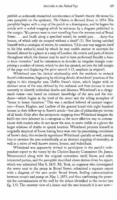
Whitehead was apparently invited to participate in the parish's inde- pendent report to the vestry by the Cholera Inquiry Committee (St. James, Westminster) along with the original committee itself, Snow, and other interested parties, and the pamphlet described above derives from his report, which was submitted May 8, 1855. Mr. York, an engineer who investigated the sewer next to the pump in Broad Street, submitted a separate report with a diagram of the area under Broad Street, finding communication between cesspit and pump on May 1,1855, and thus ccmfirming the poten- tial for contamination of the well by the infant identified as the vector (see fig. 3.5). The cutaway view of a house and the area beneath it is not new-

FIGURE 3.5. Well Diagram in General Board Report. From General Board of Health. Medical Coun- cil. Appendix to Report of the Committee for Scient$ic Inyuiries in Relation to the Cholera Epidemic of 1854. London: Eyre and Spottiswoode, 1855.

Invisible to the Naked Eye
many sanitary illustrations drew cross sections of buildings, showing the cel- lars or sewers below-but these earlier illustrations were fanciful illustra- tions of general truths (Gavin's lodging house) rather than scientific docu- ments of specific conditions.
The combination of Snow's mapping and Mr. York's drawing of the prox- imity of the well and cesspit revealed hidden features of the built environment which were dangerous to health and which could only be revealed by experts, medical or structural. Whitehead could verify Snow's thesis with his house- to-house data checking, but neither he nor any other layperson would have developed Snow's hypothesis, an educated guess, indeed, based on'a detailed professional knowledge, not only of the body and theories of its functioning, but of earlier professional publications on the cholera. Whitehead carefully notes his relationship to the limitations of the different kinds of knowledge:
The subject of defective drainage ought perhaps not to be handled by any but practical men. As there is little need however of a special or technical education to render one sensible of greviously offensive stench, I may at least venture upon the assertion that many of the house drains in Broad St. are in a condition peremptorily demanding the attention of gentlemen profession- ally acquainted with such matters. (in Report on the Cholera Outbreak in the parish of St.Jamesj, 151)
A decade earlier, of course, under Chadwick, there would have been no need to defend the validity, and in fact, priority of such common sense perceptions. Snow's report inaugurated a new era and new standard of evidence or, more accurately, introduced the public to the emerging standards of the medical professional with surgical training in morbid anatomy and tissue theory.
The Report on the Cholera Outbreak in the Parish ofst. James? compiled by the vestry committee contains a map, explained on the frontispage:
This Map is the same as that which illustrated the Report of Messrs. Fraser, Ludlow and Hughes [that is, in the general board report's appendix to the report to the general board] on the Cholera outbreak in this district. It is founded on the Map published in Mr. Cooper's Report to the Commission- ers of Sewers; but St. Anne's Court and the neighbourhood have been added to it, and the fatal attack which occurred in the district throughout the whole epidemic have been inserted in their respective localities where they could be accurately determined.
In the text, the authors note that the Commissioners of Sewers' map was created in response to their investigation of the epidmic in September 1854; the vestry also consults the Craven estate archives: T h e map is reproduced faithfully and then given two additions: 1851 sewers are picked out in pale
72 Mapping Disease in the Metropole
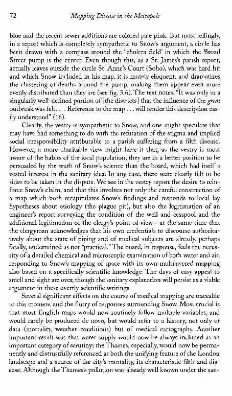
blue and the recent sewer additions are colored pale pink. But most tellingly, in a report which is completely sympathetic to Snow's argument, a circle has been drawn with a compass around the "cholera field' in which the Broad Street pump is the center. Even though this, as a St. James's parish report, actually leaves outside the circle St. Anne's Court (Soho), which was hard hit and which Snow included in his map, it is mutely eloquent, and dramatizes the clustering of deaths around the pump, making them appear even more evenly distributed than they are (see fig. 3.6). The text notes, "It was only in a singularly well-defined portion of [the districts] that the influence of the great outbreakwas felt. . . . Reference to the map . . .will render this description eas- ily understood" (16).
Clearly, the vestry is sympathetic to Snow, and one might speculate that may have had something to do with the refutation of the stigma and implied social irresponsibility attributable to a parish suffering from a filth disease. However, a more charitable view might have it that, as the vestry is most aware of the habits of the local population, they are in a better position to be persuaded by the truth of Snow's science than the board, which had itself a vested interest in the sanitary idea. In any case, there were clearly felt to be sides to be taken in the dispute. We see in the vestry report the desire to rein- force Snow's claim, and that this involves not only the careful construction of a map which both recapitulates Snow's findings and responds to local lay hypotheses about etiology (the plague pit), but also the legitimation of an engineer's report surveying the condition of the well and cesspool and the additional legitimation of the clergy's point of view-at the same time that the clergyman acknowledges that his own credentials to discourse authorita- tively about the state of piping and of medical subjects are already, perhaps fatally, undermined as not "practical." The board, in response, feels the neces- sity of a detailed chemical and microscopic examination of both water and air, responding to Snow's mapping of space with its own multilayered mapping also based on a specifically scientific knowledge. The days of easy appeal to smell and sight are over, though the sanitary explanation will persist as a viable argument in these overtly scientific writings.
Several significant effects on the course of medical mapping are traceable to this moment and the flurry of responses surrounding Snow. Most crucial is that most English maps would now routinely follow multiple variables, and would rarely be produced de novo, but would refer to a history, not only of data (mortality, weather conditions) but of medical cartography. Another important result was that water supply would now be always included as an important category of scrutiny; the Thames, especially, would now be perma- nently and distrustfully referenced as both the unifying feature of the London landscape and a source of the city's mortality, its characteristic filth and dis- ease. Although the Thames's pollution was already well known under the san-
74 Mapping Disease in the Metropole
Southwark and Vauxhall Company's water from Battersea was "the filthiest stuff ever drunk by a civilized community" (5).
The demonization of the Thames, which corresponded well to sanitari- ans' long-standing observations that the low-lying, damp areas near the river were insalubrious, enabled a certain shorthand. London had always been mapped with the Thames as its most significant geographical, mercantile, and visual feature, and the riverbanks had for many years been associated with miasma and pollution. As early as 1852, the Report on the Mortality of Cholera in England: 1848-1849 contains an innovative schematic map of London sub- districts, simplifying actual topography in favor of an abstract overview (see fig. 3.7). The Thames is shown as a straight line, and the positions of subdis- t r ic t~ are shown relative to each other in the simplest sense, by placing text about mortality ratios next to each other in rough relationship to the place to which the text refers. Topography disappears in favor of an absolute distinc- tion between north and south of the river, as all parishes south of the river appear at the same level, despite the fact that there is a significant difference in placement. (Of course, this map is intended to be read in relation to the many other maps contained in the report.)
Cartographic historians have said that there is a trend toward increasing sophistication in mapping in this period, which, as I have said earlier, does not bear up under scrutiny. But what cartographic historians interested in topo- graphically realistic maps have missed is the increasing trend in some areas of thematic cartography toward schematization and abstraction, ofwhich this is an excellent example. (One might think today of the London tube map, an excellent intuitive guide to transport, but one that distorts the actual terrain of the city to an unrecognizable extent in the interests of its primary purpose.) The use of abstract maps, which we also saw earlier in Oxford, assumes a reader who can supply the missing information, and also supply a sophisti- cated reading schema which will sort necessary from unnecessary information, and information based on typical "realist" cartographic protocols (a northeast line still means northeast) from those for which realist demands may be dis- carded (a line that is twice as long as another may not accurately represent ratios of space). I t also-and this is crucial-implies a space susceptible to abstraction. If Britain is a space of palimpsest, implying layers of history-con- taining spaces which encode different levels of progress in a kind of layered narrative, it is also a space susceptible to perfection, perfection being the reconstruction of space in the image of a more perfect and pellucid abstrac- tion. I n the abstract maps, one sees through the irrelevant presence of a cer- tain topography-a hill, a crowded street-to the essential truths of space and spatial relations between essential features. Now attention focused on. the actual flow of water and its relation to the city. London could be easily con- ceived as a totality, a single connected body, relative to its great river.

-a -- " . 4 , L " X * l i , m - 1 . " s I , ,"
"3 " P 1, " .. 1 * . . , , A * P ~ ~ ~ = E
" '1 1x1" * t ,XI l
F'1 C" & s: * > '3 L L
b w l ) 2:': WR==-I Y I": Mslow: *WW 75 w-db
76 Mapping Disease in the Metropole
Earlier sanitary mapping, under Chadwick, tended to define communities in terms of a responsibility to cleanliness and to controlling the dirty and vicious tendencies of the lower classes-a maternal combination of housekeep- ing, punishments, and exhortations against bad behavior. The citizen's respon- sibility was to directly and visually monitor the community, and attempt to redeem the childlike, "barbaric" underclass, presumed directly responsible for lack of cleanliness. With the emergence of the medical model in the late 1850s, however, we see an increasing emphasis on the role of hidden relations that can only be interpreted by medics, surveyors, and engineers. The citizens delegate individual authority to these experts, who then represent that authority and intervene in the physical infrastructure of the urban body in the interest of the community. Social mapping begins to split off-poverty and crime are still in the domain of the interested (and increasingly feminine) individual volunteer who maternally attempts to modify behavior, such as the Bible ladies and Octavia Hills. Sanitary mapping, however, concerns itself with an environment which is seen as deterministically related to disease, even though the choice of living in that environment is still seen as a culpable decision-a perversion of the natural desire for cleanliness. Such maps served to construct a vision of the city and its populations as a totality or organism which could be understood spatially and treated to achieve compliance with an ideal of urban transparency and conformity between geographic factors and human behavior. Abstract mapping reduced the community to its essential (and largely nonhuman) ele- ments and posited a utopian abstract space in which only ideally functional ele- ments had meaning and thus were visible. It posited the possibility of a space with all "noise," all irrelevant and therefore destructive distractions eliminated.
If barbarism is a feature of landscape, often below the surface in its sew- erage, its cesspools and wells, its soil quality and the level of the water table, it is a history which can be fixed, purged. Barbarism can also result from the imposition of the perils of modernity on what was formerly a perfectly civi- lized, but is now an inadequate infrastructure-that is, if the massing of bod- ies in the modern city is a species of barbarity, improving water supply and sewerage, as well as housing, can create conditions in which civilizing, cleans- ing, and separating those massed bodies becomes possible. Matching land- scape, both natural and built, to properly socialized bodies engaging in prop- erly socialized behaviors is a matter of eliminating these layers of dissonance and reinscribing all within a single layer of time-modernity. However, in order to do this, all those layers must be mapped to identify the points of dis- sension. Thus we see micromappings of districts-not only street by street, but house by house and finally down to the level of microfauna in some cases. For example, as we have seen, the Broad Street epidemic which proved so fruitful for Snow's investigations provoked many other mappings, including one that mapped the microorganisms present in the water house by house.

Invisible t o the Naked Eye
Thus the city and its maps function as palimpsests, showing levels of space and discrepancies between times-the time of modernity and the bar- baric relics of the past which infect the modern body (largely, though not entirely through the bodies of the backwards, barbaric working classes and - - Irish underclass). Abstract maps are both a means of achieving a more per- fectly modern space and its ideal representation (see Pike). Old Father Thames and his filthy water, representing sewage, the eruption of the grotesque lower bodily strata into the civilized realm of the modern self, become both a problem to be resolved in the name of the modern city and the characteristic sign of the unregenerate city itself.
As we have seen, medical mapping allowed medics to cultivate a unique professional voice in public affairs. It also envisioned (and thus, in part, cre- ated) a larger spatial entity as vitally connected and participating in the same structure, as in Snow's water maps of London and those which followed. If one portion of that structure was unhealthy, it could affect the entire organ- ism through its circulatory mechanisms. Unlike, say, Gavin's report, which emphasized the obscurity and isolation of Bethnal Green even while it ges- tured toward the compromised health of the urban whole, Snow's work vitally connects the visually and imaginatively isolated outbreak in St. James's with the entire urban epidemic, and with portions of the city located far from each other, through its water conduits. The city itself, then, could be seen anatomically as an organism, with circulatory systems vulnerable to contam- ination which extended throughout the entire urban body rather than mias- matically within a small radius; invisible underground conduits would carry infection even to apparently "clean and sweet" areas-a point reinforced by the irony that most residents drank from the Broad Street pump because the water tasted better than that of surrounding pumps. As Snow pointed out, decaying organic matter actually aerated the water; it was precisely that which made the water dangerous which made it seem most pure to the inex- pert senses.
Further, Snow's work located the evil below the surface, within the "body" of the city and requiring a physician's analysis and a quasi-surgical interven- tion; the city itself came to be seen as a problematic organism, related both to its geography (poor drainage, water sources) and the activity of its population (drinking from particular sources, disposal of waste), which itself was in part determined by geography (people have to have water; they get it where they can). No longer could the city be seen as a basically healthy organism con- taining some specific problem locations, requiring local cosmetic intervention. The years of attention to morbid anatomy and increasing importance of sur- geons as a professional group since the 1830s almost. certainly had a part in this shift from surface to depth, as it did in the shift from a sanitary to a med- ical model, as did the departure of Chadwick and the ascendancy of Farr.

78 Mapping Disease in the Metropole
The maps also, in their anatomical rhetoric, treat the city as analogous to a body. This is particularly true of the larger scale maps, such as Snow's sec- ond one. The city, a fusion of human bodies and geographic setting, "sickens" with contamination. The human bodies, invisible on the map of homogenous space that is the city, are represented by the personification of the city itself as population. The mapmakers and readers are obsessed with visibility and truth; the idea that the maps will make "visible at a glance" the problems and relationships under study is pervasive. Some such wording almost always accompanies the mapmaking enterprise. After all, the map purports merely to represent what is there-a material reality. Yes at the same time, thematic maps, especially medical ones, attempt to uncover hidden relationships, and as we have seen, often are not clear at all without the doctor's accompanying text. Here too, there is a truth claim: the doctor will make visible the invisi- ble, but the untrained eye will still require a legend to see the reality so clearly on display.
Instead of the individual parishes which middle-class people must care for, as in Gavin's work, we see a large interconnected city wherein disease in - one portion threatens the life of all; furthermore, remedies must be applied to the invisible underground structure of the city through its circulatory mecha- nisms-its sewers and cesspits, its water conduits-rather than the removal of obvious superficial nuisances like dungheaps. The poverty of the dwellers of Golden Square is not seen as an important factor (in fact, Snow deemphasizes the fact that the outbreak is in a slum, concentrating on promoting an image of the neighborhood as habited by respectable artisans, probably in order to discourage recourse to sanitary e ~ ~ l a n a t i o n s ) . ~ Conceiving a geographical con- struct as a community and in turn as a body enabled these medics and social experts to bring the city conceptually into the domain of the social. One understanding of the city-as a region filled with private properties-was powerful in militating against centralized governmental intervention in sani- tation and housing. If the city, however, were not merely a dwelling place of inappropriate bodies, but identical with them, then the city itself entered the legitimate domain of social intervention, which ultimately authorized not only sanitary, educational, and housing programs directed by government, but eventually allowed them to be government supported as well.
Benjamin Ward Richardson supposes that Snow's work did not circulate widely, but certainly Snow was widely respected and published in reputable journals at this point, and had reprinted and circulated many of his works in tract form; he was also widely cited, though he does correspond with various journals to correct others' lack of acknowledgment of his priority5 In short, the medical community was certainly aware of Snow's theories fairly early on, even though it took a long while for them to be completely accepted. Signif- icantly, William Farr of the General Registrar's Office took a keen interest in

Invisible to the Naked Eye 79
Snow's work and data, though he initially opposed his conclusions. In the 1860s, Farr himself proclaimed Snow correct (though he had agreed with some of Snow's conclusions as early as 1852), but even then, most doctors did not subscribe to the belief in a specific disease agent, although the interaction of environmental effects and contaminated water were believed to be delete- rious. As late as 1867, D. K. Whittaker says that cholera "germs" (here used in the sense of "cause," not the later meaning of a specific unicellular disease agent) are commonly held to be contained in the excreta of cholera sufferers- a theory he attributes to Orton, not Snow-but also says "it is usual to hold that in their recent state they do not propagate the disease,'that they have first to go through a process of fermentation"(25), a theory also championed by William Farr. In any case, by the 1860s, Snow is rarely not mentioned, and the first map, at least, was widely perused and imitated.
William Farr's Report on the Cholera Epidemic of1866 in England (1868) unreservedly acknowledges Snow to have been correct, referring to Snow's papers extending back to 1849, to the General Board's report of 1855, and to the subsequent committee report by Snow, Whitehead et al. published in 1855 (St. James). The whole report is geared toward examining the condition of the water, and two choropleth maps show mortality and correlate with water supply. The water companies came under public investigation for their role in providing unsafe water in the 1866 epidemic. (Their claims to have provided only filtered water became laughable in the face of consumers' evi- dence that live eels had emerged from some pumps [Appendix to Report From Select Committees on East London Water Bills, 355-571). The water companies' desperate counter that the liveliness of the eels proved the salubrity of the water was not persuasive.)6 By this time, maps had become the unquestioned and privileged tool for epidemiological study, and indeed, for all statistical research on the social body. Farr writes, with some satisfaction, that, "personal inspection, the use of maps, such information as we had the means of getting from the registrars, the health officers and other persons, enabled us week by week to track the epidemic through this vast metropolis" (Report on the Cholera 98)'-a metropolis at last, for a select few, visible at a glance.

Invisible to the Naked Eye 73
FIGURE 3.6. St. James's Vestry map, excluding St. Anne's: detail. From Report on the Cholera Outbreak in the Parish of St. JarnesS, Westminster, During the Autumn of 1854. Presented to the Vestry by the Cholera Inquiry Committee, July 1855. London: J. Churchill, 1855.
itarians, it was part of a general campaign against dirt and damp encompass- ing all waterside areas. Snow's figures could not be ignored, however, even by them, and now it was the drinking of dirty water that came to mind, the inva- sion of the body by the city's wastes. John Simon, in his General Board of Health report, Report on the Last Two Cholera Epidemics ofLondon, as A'ected by the Consumption of Impure Water, bases his extended map of the metropoli- tan water companies on the same scheme as Snow's and admits that the