investigations and management of new jersey’s freshwater ... · freshwater fishes for both...
TRANSCRIPT

Investigations and Management
of New Jersey’s Freshwater
Fisheries Resources
2012
State of New Jersey
Division of Fish and Wildlife
Bureau of Freshwater Fisheries


This grant was paid for by fishing license sales and
matching Dingell-Johnson/Wallop-Breaux funds
available through the Federal Sportfish Restoration Act.
Investigations and Management
of New Jersey’s Freshwater
Fisheries Resources
2012
Including
Sport Fish Restoration Grant F-48-R
Job Performance Reports Segment 25
(January 1, 2012 – October 31, 2012)
and
Final Reports
March 2012
New Jersey Department of Environmental Protection
Division of Fish and Wildlife
Bureau of Freshwater Fisheries
Research and Management Unit


State of New Jersey
Chris Christie
Governor
Kim Guadagno
Lt. Governor
New Jersey
Department of Environmental Protection
Bob Martin
Commissioner
Rich Boornazian
Assistant Commissioner
Natural and Historic Resources
Division of Fish and Wildlife
Dave Chanda
Director
Larry Herrighty
Assistant Director


Investigations and Management
of New Jersey’s Freshwater
Fisheries Resources
2012
BUREAU OF FRESHWATER FISHERIES
Report Prepared By:
Shawn Crouse Pat Hamilton Christopher Smith
Mark Boriek Lisa Barno
With the assistance of:
Scott Collenburg, Tom Peck, Ross Shramko,
Stephanie George, Luke Diglio, Brian Neilan,
Jamie Darrow, and Bill King
New Jersey’s Freshwater Research and Management activities are funded
entirely by New Jersey’s licensed anglers. These activities benefit the state’s
8 million residents by protecting and assessing
New Jersey’s vital freshwater resources.
Clean water for fish means clean water for us and generations to come

i
Table of Contents
Introduction 1
Bureau of Freshwater Fisheries 2
Research and Management Unit 3
Funding 5
2012 Field Sampling Locations
List of Field Sampling Locations by Funding and Project 7
Map of Field Sampling Locations 15
Federal Funded Project Summaries (Grant F-48-R)
Project I: Investigations and Management of Anadromous Fisheries
Job 5 American Shad Restoration in the RaritanRiver 16
Project II: Investigations and Management of Coldwater Fisheries
Job 7 Inventory of Trout Production Streams 17
Job 11 Assessment and Restoration of Wild Brook Trout 17
Project III: Investigations and Management of Warm and
Coolwater Fisheries
Job 1 Inventory of Lakes, Ponds, and Rivers 18
Job 2 Assessment and Management of Aquatic Invasive Fishes
and Plants 19
Project IV: Assessments of Biological Integrity and Recreational
Use of New Jersey’s Inland Waters
Job 1 Assessment and Classification of New Jersey’s Fresh Waters 22
Job 2 Mapping of the State’s Aquatic Resources 24
Job 3 Angler Attitude, Preference and Use Survey 25
Job 5 Management of Diseases and Fish Health in Wild Populations
(and FW-69-R-16, Job F-1 Diagnosis of Diseases in Fish) 25
Hunter and Angler Funded Project Summaries
Freshwater Permits 28
Information and Education 29
Native Fishes 32
Trout Stocking Program - Allocations 33
Species Management
Brook Trout 34
Lake Trout 36
Trout 37
Largemouth and Smallmouth Bass 39
General Warmwater Assessment of Lakes and Ponds 40
Fish Salvages 41
Habitat Restoration and Technical Assistance 42

ii
Data
Stream Electrofishing Survey Data 45
Dissolved Oxygen and Temperature Data 92
Literature Cited 112
Appendices
A Field Sampling Protocols –Lake Profiles and Wadeable Streams
B Habitat Assessments – High Gradient Streams (w/regional modifications)
Low Gradient Streams (w/regional modifications)
C Checklist of Freshwater Fish Species
D Federal Grant F-48-R-Performance Reports (Segment 25) & Final Reports
(will be made available at www.njfishandwildlife.com/fshresmgt.htm)

1
INTRODUCTION
In 2012, the Bureau of Freshwater Fisheries Research and Management Unit conducted
fisheries surveys at 80 different waterbodies throughout the state, demonstrating the
diversity of the state’s aquatic resources by covering a variety of project objectives.
Largemouth and smallmouth bass, panfish, and/or lake trout were targeted at 21 lakes to
gather data to better manage our fisheries. These and other ongoing efforts are geared
towards maintaining and enhancing NJ’s trophy warm, cool, and coldwater fisheries
found in nearly every corner of the state. The success of these fisheries, coupled with an
aggressive three season trout stocking program, makes New Jersey’s fishing slogan, “It’s
Never Been Better” more true than ever before.
Of the 46 stream surveys, 26 were conducted as part of continuing efforts to assess and/or
classify New Jersey’s fresh waters. These assessments use important stream health
indicators such as brook, brown, and rainbow trout to identify high water quality and
critical habitat areas. The state’s stream classification system is the cornerstone in
protecting our critical watersheds. This data is also useful in documenting changes in the
state’s trout producing waters and provides information on the current distribution of
brook trout, New Jersey’s only native trout species. This species demands the best of the
best with regards to habitat and water quality and is a true beacon to the current condition
of our northern waters. The decline of brook trout due to land use changes has been
documented throughout its entire native range.
As the emphasis on invasive species management continues to grow, the Bureau
continued efforts to control exotic species such as Asian swamp eels, snakeheads, and
even invasive plants such as water chestnut. Bureau personnel visited five waterbodies to
document and/or remove invasive aquatic species.
Every fisheries survey provides insight to the current distribution of our native fishes.
Although most native fishes are not sought after by anglers, they are useful indicators of
stream health and contribute greatly to our biodiversity. They are particularly valuable as
indicator species in our southern waters, where trout are not naturally found. Of the
state’s 60 native fishes, several such as bridle, ironcolor, and comely shiners and black-
banded and banded sunfish are of particular interest as their numbers appear to have
dramatically declined over the years. Efforts are underway to resample areas once
inhabited by rare species and to assess their statewide status and distribution.
Work critical to managing important anadromous species such as American shad,
blueback herring, and alewife also continues. The final federal aid report was completed
for a project in which a recovering population of American shad was monitored,
intermittently from 1996 to 2012, via passage through the Raritan River’s Island Farm
Weir. Recent action was taken to improve fish passage on the Raritan River, as two of
the lowermost fish passage impediments were removed, the Calco Dam (summer of
2011) and the Robert Street Dam (summer of 2012). The Nevius Street Dam is
scheduled for removal in 2013.
Full-time Freshwater Fisheries personnel are complemented by a dedicated and talented
seasonal staff, which provide incredible insight and enthusiasm necessary to raise fish

2
within our hatcheries and conduct fisheries inventories across the State, not to mention
the countless tasks that ultimately maintain and enhance New Jersey’s fisheries resources.
Bureau of Freshwater Fisheries
The mission of the Bureau of Freshwater Fisheries (BFF) is to protect and manage the
state’s freshwater fish resources to maximize their long-term biological, recreational, and
economic value for all New Jerseyans. Our goals are:
1) To maintain New Jersey’s rich variety of freshwater fish species at stable
healthy levels and enhance the many habitats on which they depend;
2) To educate New Jerseyans on the values and needs of our freshwater fish
resources and to foster a positive human/wildlife co-existence;
3) To maximize the recreational and commercial use of New Jersey’s
freshwater fishes for both present and future generations.
The Bureau of Freshwater Fisheries is responsible for the propagation, protection, and
management of the State’s freshwater fisheries resources as well as promoting its
recreational use. In addition to raising and distributing over 3.5 million fish annually, the
Bureau conducts research and management surveys, classifies the state’s waterways,
provides technical input on a variety of watershed and habitat based issues, facilitates
habitat restoration projects, serves as a liaison to a variety of sportsmen groups, and
provides information to the general public, in a variety of forums, concerning the status
of the State’s fishery resources. The Bureau also administers approximately 600 permits
annually to provide for the effective management and protection of the State’s aquatic
resources.
Organizationally, the Bureau is divided into two units; the Fish Culture Unit, responsible
for the raising of 19 species of fish and the stocking of over 300 waterbodies each year,
and the Research and Management Unit, responsible for the protection and management
of the aquatic resources throughout the State.
The Fish Culture Unit is comprised of the Pequest Trout Hatchery and the Charles O.
Hayford Hatchery in Hackettstown. The Pequest Trout Hatchery raises and stocks over
725,000 brook, brown, and rainbow trout each year during the spring, fall, and winter
trout stocking programs. Pequest also provides brown trout for the Division’s elusive Sea
Run Brown Trout program in the Manasquan River. The Hackettstown Hatchery raises
15 species of freshwater fish with over 1,500,000 million released each year throughout
the state. The hatchery also supplies county Mosquito Control Commissions, under the
direction of the State Mosquito Control Commission, with sunfish, killifish, and
Gambusia to assist with the Commission’s efforts for effective mosquito control. The
Hackettstown Hatchery celebrated its 100th anniversary with an Open House on June 2
and 3rd. This was the first time in almost thirty years the hatchery was opened to the
public. Over 15,000 attended the two day event making it one of the largest Division
events. Both the Pequest and Hackettstown hatcheries are in operation 24 hours a day, 7
days a week.

3
Research and Management Unit
The Research and Management Unit has personnel in two regionally placed offices;
Lebanon Field Office (Hunterdon) and the Southern Regional Office (Camden). This
unit oversees the management and protection of the State’s over 27,000 miles of streams
and over 400 public lakes. The biologists also carry out a number of freshwater research
projects each year.
The Research and Management Unit conducts fishery surveys, classifies the state’s
waterways, provides technical input on a variety of watershed and habitat based issues,
facilitates habitat restoration projects, serves as liaisons to a variety of sportsmen groups,
and provides information to the general public, in a variety of forums, concerning the
status of the State’s fishery resources. The Research and Management Unit also
administers permits for fish stocking, water lowering, commercial harvests, and scientific
collecting to further provide for the effective management and protection of the State’s
aquatic resources.
For management purposes, the State is divided into six regional watershed management
areas (Figure 1). Due to current staffing shortages vacant management regions have been
subdivided and reassigned to remaining biologists. In addition to regional
responsibilities, each biologist also has a specific area of expertise and oversees related
research and management programs. The Bureau also has a fish pathologist.
Northwest Region:
(Upper Delaware, Central Delaware, & Wallkill Drainages)
Patricia Hamilton – Coldwater Research & Management
Federal Aid Coordinator
Northeast Region:
(Passaic, Hackensack, & Hudson and Upper Atlantic Drainages)
Mark Boriek – Anadromous Fish Management
Raritan Region:
(Raritan, Arthurkill, Raritan Bay, Shrewsbury, & Navesink)
Shawn Crouse – Native Fishes and Index of Biotic Integrity
Southern Region:
(Lower Delaware & Lower Atlantic Coastal Drainages)
Chris Smith – Warmwater Research & Management
Anadromous Fish Management
Delaware River Region: - Delaware River Mainstem
VACANT
Fish Pathologist
Jan Lovy Ph.D.

4
Figure 1. Fisheries Management Regions.

5
FUNDING
The Division’s Bureau of Freshwater Fisheries is funded entirely by New Jersey
sportsmen, through the sale of fishing licenses and permits and through a Federal excise
tax on the manufacturing of hunting and fishing related equipment. This includes both
the Bureau’s fish culture operations and research and management activities. This “user-
pays” system has made great strides in financing the management of New Jersey’s fish
and wildlife resources, not only to the benefit of licensed hunters and anglers but to every
one of the state’s over 8 million residents. Wildlife associated recreation also generates
$2.2 billion dollars into the state’s economy each year, with an estimated 300,000
freshwater anglers generating $138 million dollars alone.
Licenses, stamps, and permits
The sale of freshwater fishing licenses and trout stamps generates over $5 million dollars
to the Division each year. Of this, 2.5 million is allocated to the Bureau of Freshwater
Fisheries to operate its two state-of-the-art fish culture facilities, the Pequest Trout
Hatchery and the Hackettstown Hatchery, and to support the state’s freshwater research
and management efforts. The remaining funds are used to fund other activities within the
Division such as Information and Education, Lands Management, and Law Enforcement,
as well as Administrative staff.
Sport Fish Restoration Program
Federal excise tax money is distributed through the Sport Fish Restoration Fund
administered by the United States Fish and Wildlife Service. The Sport Fish Restoration
Program, established from an amendment to the Dingell-Johnson Act of 1950, provides
funding for the management, conservation and restoration of fishery resources. The
Sport Fish Restoration program is funded by revenues collected by the manufacturers of
fishing rods, reels, creels, and lures, who pay an excise tax on these items to the U.S.
Treasury.
For Federal Fiscal Year 2011, New Jersey was allocated $1,148,183 for Freshwater Fish
Restoration. Of this amount, $900,000 is allocated to support fish culture operations for
put and take, and delayed take fisheries programs (Grant F-50-D) and $248,183 is
available for research and management programs (Grant F-48-R). Unfortunately, due to
critical staffing shortages, the Research and Management Unit is unable to use a
significant portion of available Federal Aid. As a result, several jobs within the grant
have been discontinued and are currently classified as inactive. The list of active and
inactive jobs funded through Grant F-48-R is found in Table 1.
The grant cycle for Research and Management runs from November 1 to October 31 of
the following year. The program is a cost-reimbursement program, where the state
covers the full amount of the approved project then applies for reimbursement for up to
75% of project expenses.
This report includes activities funded by both the dedicated monies of Hunters and
Anglers funds and the Sport Fish Restoration Program. This report contains a site list of
field surveys conducted in 2011 (Table 2) and a location map (Figure 2).

6
Table 1.
Active Jobs under Federal Aid Grant F-48-R-25 (January 1, 2012 – October 31, 2012)
Project I Investigations and Management of Anadromous Fisheries
Job I-5 American Shad Restoration in the Raritan River
Project II Investigations and Management of Coldwater Fisheries
Job II-7 Inventory of Trout Production Streams
Job II-11 Assessment and Restoration of Wild Brook Trout
Project III Investigations and Management of Warm and Coolwater Fisheries
Job III-1 Inventory of New Jersey Lakes
Job III-2 Assessment and Management of Aquatic Invasive Fishes and Plants
Project IV Assessments of Biological Integrity and Recreational Use of New Jersey’s
Inland Waters
Job IV-1 Assessment and Classification of New Jersey’s Fresh Waters
Job IV-2 Mapping of the State’s Aquatic Resources
Job IV-3 Angler Attitude, Preference, and Use Survey
Job IV-5 Management of Diseases and Fish Health in Wild Populations
Inactive Jobs under Federal Aid Grant F-48-R-25 (January 1, 2012 – October 31, 2012)
Project I Investigations and Management of Anadromous Fisheries
Job I-1 Delaware River American Shad Population Estimate
Job I-2 Delaware River Juvenile American Shad Outmigration
Job I-7 Inventory and Status of Anadromous Clupeid Spawning Migrations in New
Jersey Freshwaters
Job I-9 Delaware River Creel Survey
Project II Investigations and Management of Coldwater Fisheries
Job II-10 Evaluation of Landlocked Salmon Introductions
Project IV Assessments of the Biological Integrity and Recreational Use of New
Jersey’s Inland Waters
Job IV-4 Index of Biotic Integrity for New Jersey's Piedmont Province

7
Table 2. 2012 Field Sampling Locations
Bureau of Freshwater
Fisheries Research and
Management Unit 2012
Field Sampling Activities
Ass
essm
en
t a
nd
Cla
ssif
ica
tio
n
Bro
ok
Tro
ut
Ass
essm
en
t
Inv
ento
ry o
f T
rou
t
Pro
du
ctio
n S
trea
ms
An
ad
rom
ou
s
La
ke
Inv
ento
ry
Inv
asi
ve
Sp
ecie
s
Info
rma
tio
n a
nd
Ed
uca
tio
n
Na
tiv
e F
ish
es
Ra
rita
n R
iver
S/B
r
Hea
dw
ate
r S
tud
y
Sp
ecie
s M
an
ag
emen
t
Tem
per
atu
re
an
d/o
r D
O M
on
ito
rin
g
RB
A S
trea
m S
am
pli
ng
Pro
toco
l A
pp
lied
*
Pa
ge
# R
esu
lts
Funding Source FEDERAL JOB # HUNTERS AND ANGLERS FUND
IV-1 II-11 II-7 I III-1 III-2
Southern Region (Lower Delaware River and Lower Atlantic Coastal)
Bostwick Lake (Cumberland) ● – 39
Cohansey River (Camden) ● – 39
Cooper River Lake (Camden) ● – 21, D
Daretown Lake (Cumberland) ● – 39
Davis Millpond (Cumberland) ● – 39
Glenn Lake (Gloucester) ● – 39
Grenloch Lake (Gloucester) ● – 39
Heritage Park Pond (Atlantic) ● – 39
Hilliards Creek (aka Millard Creek UNT)
(Gibbsboro, Camden) ● No 20, D
Lake Audrey (Cumberland) ● – 39
Maple Lake (Atlantic) ● – 39
Mary Elmer Lake (Cumberland) ● – 39
Patriot Lake (Atlantic) ● – 39

8
Bureau of Freshwater
Fisheries Research and
Management Unit 2012
Field Sampling Activities
Ass
essm
en
t a
nd
Cla
ssif
ica
tio
n
Bro
ok
Tro
ut
Ass
essm
en
t
Inv
ento
ry o
f T
rou
t
Pro
du
ctio
n S
trea
ms
An
ad
rom
ou
s
La
ke
Inv
ento
ry
Inv
asi
ve
Sp
ecie
s
Info
rma
tio
n a
nd
Ed
uca
tio
n
Na
tiv
e F
ish
es
Ra
rita
n R
iver
S/B
r
Hea
dw
ate
r S
tud
y
Sp
ecie
s M
an
ag
emen
t
Tem
per
atu
re
an
d/o
r D
O M
on
ito
rin
g
RB
A S
trea
m S
am
pli
ng
Pro
toco
l A
pp
lied
*
Pa
ge
# R
esu
lts
Funding Source FEDERAL JOB # HUNTERS AND ANGLERS FUND
IV-1 II-11 II-7 I III-1 III-2
Southern Region (Lower Delaware River and Lower Atlantic Coastal) (cont.)
Silver Lake (Gibbsboro, Camden) ● – 20, D
South Vineland Park Pond (Cumberland) ▲ ● ▲ – 93, D
Stewart Lake (Gloucester) ● – 21, D
Parvin Lake (Cumberland) ● – 39
Northwest Region (Upper Delaware River, Central Delaware River, and Wallkill)
Big Flat Brook
-Between Rt. 206 and Rt. 560 bridge ▲ ▲ ▲ ● Yes 48
-Blewett Tract ▲ ▲ ▲ ● Yes 46
-Upstream of Blewett Tract ▲ ▲ ▲ ● Yes 47
Cranberry Lake (Sussex) ▲ ● – 94, D
Flat Brook ▲ ▲ ▲ ● Yes 49
Franklin Pond (Sussex) ▲ ● – 40
Gardner’s Pond (Sussex) ▲ ● – 95, D
Hakihokake Creek (trib.) (Wydner) ▲ ▲ ● ▲ Yes 50, D

9
Bureau of Freshwater
Fisheries Research and
Management Unit 2012
Field Sampling Activities
Ass
essm
en
t a
nd
Cla
ssif
ica
tio
n
Bro
ok
Tro
ut
Ass
essm
en
t
Inv
ento
ry o
f T
rou
t
Pro
du
ctio
n S
trea
ms
An
ad
rom
ou
s
La
ke
Inv
ento
ry
Inv
asi
ve
Sp
ecie
s
Info
rma
tio
n a
nd
Ed
uca
tio
n
Na
tiv
e F
ish
es
Ra
rita
n R
iver
S/B
r
Hea
dw
ate
r S
tud
y
Sp
ecie
s M
an
ag
emen
t
Tem
per
atu
re
an
d/o
r D
O M
on
ito
rin
g
RB
A S
trea
m S
am
pli
ng
Pro
toco
l A
pp
lied
*
Pa
ge
# R
esu
lts
Funding Source FEDERAL JOB # HUNTERS AND ANGLERS FUND
IV-1 II-11 II-7 I III-1 III-2
Northwest Region (Upper Delaware River, Central Delaware River, and Wallkill) (cont.)
Iliff Lake (Sussex) ▲ ● – 96, D
Lake Aeroflex (Sussex) ▲ ● – 97, D
Lake Hopatcong (Morris/Sussex) ▲ ● – 98, D
Lake Marcia (Sussex) ▲ ● – 99, D
Lake Rutherford (Sussex) ▲ ● – 100, D
Mountain Lake (Warren) ▲ ● – 101, D
Furnace Lake (Warren) ▲ ● – 102, D
Stony Lake (Sussex) ▲ ● – 103, D
Swartswood Lake (Sussex) ▲ ● – 104, D

10
Bureau of Freshwater
Fisheries Research and
Management Unit 2012
Field Sampling Activities
Ass
essm
en
t a
nd
Cla
ssif
ica
tio
n
Bro
ok
Tro
ut
Ass
essm
en
t
Inv
ento
ry o
f T
rou
t
Pro
du
ctio
n S
trea
ms
An
ad
rom
ou
s
La
ke
Inv
ento
ry
Inv
asi
ve
Sp
ecie
s
Info
rma
tio
n a
nd
Ed
uca
tio
n
Na
tiv
e F
ish
es
Ra
rita
n R
iver
S/B
r
Hea
dw
ate
r S
tud
y
Sp
ecie
s M
an
ag
emen
t
Tem
per
atu
re
an
d/o
r D
O M
on
ito
rin
g
RB
A S
trea
m S
am
pli
ng
Pro
toco
l A
pp
lied
*
Pa
ge
# R
esu
lts
Funding Source FEDERAL JOB # HUNTERS AND ANGLERS FUND
IV-1 II-11 II-7 I III-1 III-2
Northeast Region (Passaic, Hackensack, and Hudson) and Upper Atlantic
Apshawa Brook ● ▲ No 51, D
Bear Swamp Brook
-Lower site ▲ ▲ ● No 52
-Upper site ▲ ▲ ● No 53
Canistear Reservoir (Passaic) ▲ ● – 108, D
Clinton Reservoir (Passaic) ▲ ● – 109, D
Den Brook ● ▲ No 54, D
Green Pond Brook ▲ ▲ ● ▲ Yes 55, D
Greenwood Lake (Passaic) ▲ ● ▲ – 21 32 D
Macopin River (trib.) (Unnamed Trib 1) ● ▲ No 56, D
Mill Brook ● ▲ No 57, D
Mill Brook (trib.) (Unnamed Trib 1) ● ▲ No 58, D
Oak Ridge Reservoir (Passaic) ▲ ● – 110, D

11
Bureau of Freshwater
Fisheries Research and
Management Unit 2012
Field Sampling Activities
Ass
essm
en
t a
nd
Cla
ssif
ica
tio
n
Bro
ok
Tro
ut
Ass
essm
en
t
Inv
ento
ry o
f T
rou
t
Pro
du
ctio
n S
trea
ms
An
ad
rom
ou
s
La
ke
Inv
ento
ry
Inv
asi
ve
Sp
ecie
s
Info
rma
tio
n a
nd
Ed
uca
tio
n
Na
tiv
e F
ish
es
Ra
rita
n R
iver
S/B
r
Hea
dw
ate
r S
tud
y
Sp
ecie
s M
an
ag
emen
t
Tem
per
atu
re
an
d/o
r D
O M
on
ito
rin
g
RB
A S
trea
m S
am
pli
ng
Pro
toco
l A
pp
lied
*
Pa
ge
# R
esu
lts
Funding Source FEDERAL JOB # HUNTERS AND ANGLERS FUND
IV-1 II-11 II-7 I III-1 III-2
Northeast Region (Passaic, Hackensack, and Hudson) and Upper Atlantic (cont.)
Passaic River
-Site 1-below confl. w/ Indian Grove Bk ● ▲ No 59, D
-Site 2-Tempe Wick Road, Mendham ● ▲ No 60, D
-Site 3-Franklin Road cul-de-sac ● ▲ No 61, D
Passaic River (trib.) (UNT #1) ● ▲ No 62, D
Passaic River (trib.) (UNT #2) ● ▲ No 63, D
Passaic River (trib.) (UNT #3) ● ▲ No 64, D
Pequannock River (trib.) (UNT #1) ● ▲ No 65, D
Pequannock River (trib.) (UNT #2) ● ▲ No 66, D
Pequannock River (trib.) (UNT #3) ● ▲ No 67, D
Pequannock River (trib.) (UNT #4) ● ▲ No 68, D
Splitrock Reservoir (Morris) ▲ ● – 111, D
Wanaque River ● ▲ ▲ Yes 69, D

12
Bureau of Freshwater
Fisheries Research and
Management Unit 2012
Field Sampling Activities
Ass
essm
en
t a
nd
Cla
ssif
ica
tio
n
Bro
ok
Tro
ut
Ass
essm
en
t
Inv
ento
ry o
f T
rou
t
Pro
du
ctio
n S
trea
ms
An
ad
rom
ou
s
La
ke
Inv
ento
ry
Inv
asi
ve
Sp
ecie
s
Info
rma
tio
n a
nd
Ed
uca
tio
n
Na
tiv
e F
ish
es
Ra
rita
n R
iver
S/B
r
Hea
dw
ate
r S
tud
y
Sp
ecie
s M
an
ag
emen
t
Tem
per
atu
re
an
d/o
r D
O M
on
ito
rin
g
RB
A S
trea
m S
am
pli
ng
Pro
toco
l A
pp
lied
*
Pa
ge
# R
esu
lts
Funding Source FEDERAL JOB # HUNTERS AND ANGLERS FUND
IV-1 II-11 II-7 I III-1 III-2
Northeast Region (Passaic, Hackensack, and Hudson) and Upper Atlantic (cont.)
West Brook ▲ ● ▲ Yes 70, D
West Brook (trib.) (UNT #1) ● ▲ No 71, D
West Brook (trib.) (UNT #2) ● ▲ No 72, D
West Brook (trib.) (UNT #3) ● ▲ No 73, D
Raritan Region (Raritan, Arthur Kill, Raritan Bay, Shrewsbury, and Navesink)
Beaver Brook (Cokesbury) ▲ ● ▲ Yes 74, D
Best Lake (Somerset) ▲ ● – 40
Electric Brook
-East Spring Road ▲ ▲ ● Yes 75
-Scenic Falls Road ▲ ▲ ● Yes 76
Grover’s Mill Pond (Mercer) ● ▲ – 32, 40
Lake Manalapan (Middlesex) ▲ ▲ ● ● – 41 105
D
Nelson Lake (Middlesex) ▲ ● – 41

13
Bureau of Freshwater
Fisheries Research and
Management Unit 2012
Field Sampling Activities
Ass
essm
en
t a
nd
Cla
ssif
ica
tio
n
Bro
ok
Tro
ut
Ass
essm
en
t
Inv
ento
ry o
f T
rou
t
Pro
du
ctio
n S
trea
ms
An
ad
rom
ou
s
La
ke
Inv
ento
ry
Inv
asi
ve
Sp
ecie
s
Info
rma
tio
n a
nd
Ed
uca
tio
n
Na
tiv
e F
ish
es
Ra
rita
n R
iver
S/B
r
Hea
dw
ate
r S
tud
y
Sp
ecie
s M
an
ag
emen
t
Tem
per
atu
re
an
d/o
r D
O M
on
ito
rin
g
RB
A S
trea
m S
am
pli
ng
Pro
toco
l A
pp
lied
*
Pa
ge
# R
esu
lts
Funding Source FEDERAL JOB # HUNTERS AND ANGLERS FUND
IV-1 II-11 II-7 I III-1 III-2
Raritan Region (Raritan, Arthur Kill, Raritan Bay, Shrewsbury, and Navesink) (cont.)
Rahway River ● ▲ No 31
Rahway River Park Lake ● ▲ – 31
Raritan River, Farm Island Weir ● ▲ – 16, D
Raritan River, S/Br.
-Svea Drive (Vasa Park) ▲ ▲ ▲ ● Yes 34, 77
-River Road, immediately above
YMCA dam ▲ ▲ ▲ ● Yes 34, 78
-River Road, immediately below
YMCA dam ▲ ▲ ▲ ● Yes 79
-Stephens Mill Road ▲ ▲ ▲ ● Yes 80
-River Road, Califon ● ▲ ▲ Yes 81, D
Raritan River, S/Br. (trib.) (Diglio Ditch) ▲ ▲ ● Yes 34, 82
Raritan River, S/Br. (trib.) (Dog Lady) ▲ ▲ ● Yes 83
Raritan River, S/Br. (trib.) (Drakestown) ▲ ▲ ● Yes 34, 84
Raritan River, S/Br. (trib.)
(N of Drakestown) ▲ ▲ ● Yes 34, 85

14
Bureau of Freshwater
Fisheries Research and
Management Unit 2012
Field Sampling Activities
Ass
essm
en
t a
nd
Cla
ssif
ica
tio
n
Bro
ok
Tro
ut
Ass
essm
en
t
Inv
ento
ry o
f T
rou
t
Pro
du
ctio
n S
trea
ms
An
ad
rom
ou
s
La
ke
Inv
ento
ry
Inv
asi
ve
Sp
ecie
s
Info
rma
tio
n a
nd
Ed
uca
tio
n
Na
tiv
e F
ish
es
Ra
rita
n R
iver
S/B
r
Hea
dw
ate
r S
tud
y
Sp
ecie
s M
an
ag
emen
t
Tem
per
atu
re
an
d/o
r D
O M
on
ito
rin
g
RB
A S
trea
m S
am
pli
ng
Pro
toco
l A
pp
lied
*
Pa
ge
# R
esu
lts
Funding Source FEDERAL JOB # HUNTERS AND ANGLERS FUND
IV-1 II-11 II-7 I III-1 III-2
Raritan Region (Raritan, Arthur Kill, Raritan Bay, Shrewsbury, and Navesink) (cont.)
Raritan River, S/Br. (trib.) (Red House) ▲ ▲ ● Yes 86
Raritan River, S/Br. (trib.) (Rickie Lake) ▲ ▲ ● Yes 87
Raritan River, S/Br. (trib.)
(SW of Budd Lake) ▲ ▲ ● Yes 34, 88
Raritan River, S/Br. (trib.) (Warmwater) ▲ ▲ ● Yes 34, 89
Round Valley Reservoir (Hunterdon) ▲ ▲ ● ● – 36 106
D
Spruce Run Reservoir (Hunterdon) ▲ ● – 107, D
Sun Valley Brook ▲ ▲ ● Yes 34, 90
Turkey Brook ▲ ▲ ● Yes 91
Watchung Lake (Somerset) ▲ ● – 41
● Funding source or reason of data collection ▲ Data are applicable to additional projects * The Bureau of Freshwater Fisheries strives to use established sampling protocols for all field sampling efforts. However, certain sampling
objectives adherence to established sampling protocols would be prohibitive to accomplishing project goals. In these instances non-standardized
surveys are performed and are identified in appropriate areas within this document.

15
Figure 2.
2012 FIELD SAMPLING SITES
DIVISION OF FISH AND WILDLIFE
BUREAU OF FRESHWATER FISHERIES
n = 90

16
American shad caught on film
passing the Island Farm Weir.
FEDERAL FUNDED PROJECT SUMMARIES
American Shad Restoration in the Raritan River (Job I-5)
The Raritan River historically supported a spawning run of American shad. In the early
1980’s, adult male and gravid female Delaware River American shad were stocked in an
attempt to reestablish a spawning run. Subsequent to that, the Island Farm Weir (a dam
the confluence of the Millstone and Raritan Rivers) was constructed by the Elizabethtown
Water Company to improve the ability of a major water purveyor to collect water for
potable water use. The weir was completed in October 1995 and the adjacent vertical slot
fish ladder, with an underground viewing chamber, opened on April 9, 1996.
Monitoring the passage of fish through the ladder
commenced on April 22, 1996 using a high resolution,
black & white video camera, time lapse VCR, and
infrared lighting system powered by two deep cycle
12-volt batteries. For the last two years, a new digital
recorder (instead of the antiquated VHS recorder) was
used to record. The operation of the camera is labor
intensive, requiring visits to the ladder to replace
batteries and tapes / SD cards. The video tapes / SD
cards were viewed (also labor intensive) at a later date
at the Lebanon Field Office and individual fish passage
data were recorded. Fish passage was routinely
monitored during the spring (typically mid-March to mid-June) from 1996 through 2003,
and in 2005, 2011, and 2012. Other parameters that were monitored included water
temperature and water flow (cubic feet per second or cfs). In 2012, the final year of this
Job, monitoring began on March 26 and continued through June 30 (97 days). During
this time, a total of 5,133 fish migrated through the ladder, 465 of which were American
shad.
All 11 years of data have been reviewed. At project completion, a total of 866 days were
recorded, with a total of 684 days deemed viewable, due primarily to river conditions. A
total of 63,829 fish migrated through the ladder, 3,752 of which were American shad.
American Shad passed through the fish ladder in the most abundance between April 15th
and May 29th. The highest abundance of American Shad travelled through the fish ladder
in 2002 with 989 individuals. They tended to travel through the ladder at water
temperatures between 10°C and 25°C and favored water flow rates between 250 and
1500 cfs. Possible reasons for this could be that with higher flow rates, turbidity was
greater, making it more difficult to view the videos for those days. Also, at higher flow
rates, the shad could swim over the weir, thus avoiding the ladder all together. The final
report, which is a summary of the research efforts, was completed in 2012 (Appendix D).
Action recently taken to improve fish passage on the Raritan River includes the removal
of two of the lowermost impediments. The only dam downstream of the Island Farm
Weir, the Calco dam, was removed during the summer of 2011. Upstream, the Robert
Street Dam, in the town of Raritan, was removed during the summer of 2012. The
Nevius Street Dam, also in Raritan, is scheduled for removal in 2013. All of the above

17
Wild brown trout from
Hakihokake Creek tributary.
Wild brook trout.
dam removals are part of a settlement through NJDEP’s Natural Resource Damages
funds.
Inventory of Trout Production Streams (Job II-7)
Wild, self-sustaining populations of brook, brown, rainbow, and lake trout are found in
New Jersey. Waters used by trout for spawning and nursery areas are classified as trout
production under the state's Surface Water Quality Standards. Wild trout are important
indicators of healthy ecosystems, requiring superior water quality and pristine habitat.
Despite the protection that state regulatory programs afford trout production waters,
ongoing changes in land use have impacted these coldwater fisheries populations. To
assess the current status of designated trout production waters a monitoring schedule has
been established to re-inventory trout production streams
that have not been surveyed recently (typically within the 20
years). The data collected is evaluated to determine if
population changes have occurred and to develop
management strategies to protect this fragile resource.
In 2012, only two surveys were specifically conducted under
Job II-11 due to other Bureau priorities (Appendix D).
Trout reproduction was confirmed in two streams, Green
Pond Brook and Hakihokake Creek (trib.) (Wydner). In
addition to field surveys, an analysis of two data sets
(historical survey data and more recently collected data) is
underway to determine if trout population changes have
occurred and if they can be attributed to changes in land
use or other factors.
Assessment and Restoration of Wild Brook Trout (Job II-11)
Anthropogenic landscape changes and past management practices have negatively
impacted New Jersey’s freshwater resources. In particular, resulting land use changes
have taken their toll on brook trout, New Jersey’s only native salmonid. Of the four
species of trout occurring within New Jersey,
brook trout are the least tolerant of habitat
degradation. Habitat alteration and fragmentation,
diminished water quality, and non-native
salmonids have contributed to the decline of wild
brook trout in New Jersey. Wild populations of
brook trout persist in less than half their original
range in New Jersey, and in some watersheds the
status of brook trout is unknown. They have been
extirpated from 96 sub-watersheds within the state.
NJ Division of Fish and Wildlife (DFW) actively participates in the Eastern Brook Trout
Joint Venture, a unique partnership initiated in 2004 to unify range-wide efforts to
protect, restore, and enhance aquatic habitat of brook trout in the eastern U.S. Through
this partnership, a comprehensive assessment of the current status and resulting

18
Electrofishing boat.
conservation plan was developed to help ensure the long-term viability of wild brook
trout, not only in New Jersey but also across their entire native range.
In watersheds where the status of wild brook trout is unknown (Eastern Brook Trout Joint
Venture’s range-wide assessment) or poorly documented, streams are surveyed using
established protocols (Appendix A). Physicochemical parameters measured include
water temperature, dissolved oxygen, pH, alkalinity, conductivity, specific conductance,
stream width, stream and depth, and substrate type. The EPA Rapid Bioassessment
sampling habitat assessment protocol is also used to assess in-stream habitat and riparian
conditions (Barbour et al. 1999) with regional modifications (Appendix B). The
information collected is entered into FishTrack, (Fish and Wildlife’s freshwater fish
computerized database) and provided to the Eastern Brook Trout Joint Venture (EBTJV)
partnership for range-wide mapping and planning purposes. NJDFW staff actively
participates in EBTJV’s planning activities. The information collected is also used to
identify and prioritize NJ watersheds and streams for wild brook trout restoration.
Appropriate projects will be initiated through partnerships with stakeholder groups
(landowners and conservation organizations such as watershed associations and Trout
Unlimited).
In 2012, 20 surveys were specifically conducted under Job II-11 to document the
occurrence of wild brook trout (Appendix D). These surveys did not document young-of-
the-year brook trout populations in any stream segments. In addition, 26 surveys
conducted under a variety of other jobs and/or funding sources (Table 2) found wild
brook trout present at 10 locations.
Inventory of Lakes, Ponds, and Rivers (Job III-1)
Successful management of New Jersey’s warm and cool water fisheries resource is based
upon specific knowledge of their physical, chemical, biological, and use characteristics.
Such knowledge may serve to direct immediate management recommendations or be
used as a base upon which to recognize future changes requiring remedial management
efforts.
The Inventory of New Jersey Lakes Project
collects physical, chemical and biological
data upon which to base fisheries
management recommendations. These
parameters are analyzed for each lake
utilizing standard sampling techniques.
Physical parameters include morphometry,
bathymetry, access, watershed, and aquatic
vegetation characteristics. Chemical
parameters include general water chemistry
and sediment nutrient characteristics. Biological parameters include fish species
composition, abundance (catch-per-unit-effort), length frequency distribution, and
calculated indices of population structure and dynamics such as proportional stock
density (PSD), relative weight (Wr), age and growth.

19
The results of individual surveys are prepared as fisheries management plans. Reports
include current status of the lake, fishery resource and recommendations for
improvements. These reports are summarized and published for dissemination to the
angling public. This year there were no lake inventory reports completed.
Assessment and Management of Aquatic Invasive Fishes and Plants (Job III-2)
New Jersey is host to over 85 freshwater fish species and of these, nearly 60 are native.
Native fishes contribute to the biological integrity of aquatic communities and may also
be economically, recreationally, and culturally important. Introductions of invasive, non-
native fish and aquatic plants are a growing concern of natural resource managers in New
Jersey and elsewhere because of their potential to dominate and destroy aquatic
ecosystems causing irreversible economic and cultural damage.
Early detection and response to emerging threats posed by invasive fishes and
macrophytes is critical in preventing their establishment and spread to other waters. A
coordinated and proactive approach to invasive species management that includes public
awareness, monitoring, control efforts, and regulatory components helps to maintain and
protect aquatic ecosystems from potentially damaging effects of invasive species.
Several non-native fishes considered invasive by other states have been recently
documented in New Jersey, including northern snakehead, Asian swamp eel, flathead
catfish, and bighead carp. In 2010, New Jersey’s freshwater fishing regulations were
amended to include a list of the following potentially dangerous fish species: Asian
swamp eel, Monopterus albus, bighead carp, Hypophthalmichthys nobolis, brook
stickleback, Culaea inconstans, flathead catfish, Pylodictis olivaris, grass carp (diploid),
Ctenopharyngodon idella, green sunfish, Lepomis cyanellus, snakeheads, Channa spp.,
oriental weatherfish, Misgurnus anguillicaudatus, silver carp, Hypophthalmichthys
molitrix, and warmouth, Lepomis gulosus. These fish have the potential to become a
significant threat to indigenous animals, the environment, or public safety. Possession
and/or release of live potentially dangerous fish species is prohibited and when these
species are encountered while angling they must be destroyed.
Freshwater anglers are also encouraged to report sightings of invasive non-native fish and
aquatic plants (such as water chestnut) to NJDFW and to submit specimens or photos for
verification. The Division’s Bureau of Freshwater Fisheries staff investigates reported
sightings of suspicious fish and aquatic plants. Sightings are confirmed through photos,
samples, or site visits. Sites where invasive fish species have been previously
documented are periodically monitored and invasive fish species captured are not
returned to the water. The Bureau works in educating the public on the identification and
issues surrounding invasive species through the Divisions’ Freshwater Fishing Digest and
website.
Invasive Fish Species Management – Asian Swamp Eel
Swamp eels were first introduced to the United States in Hawaii some time around 1990.
It was first identified as being present in the continental United States in 1994 based on
specimens collected in ponds at the Chattahoochee Nature Center, located north of
Atlanta, Georgia. They were first found in Florida in 1997. Three populations are

20
Asian swamp eel.
Northern snakehead.
known. The Asian swamp eel was first collected by the NJ Division of Fish and Wildlife
Biologists in June 2008. Based on the size range of those individuals collected, the
swamp eels were present prior to 2008 and had successfully reproduced in Silver Lake.
In 2012 the Bureau of Freshwater Fisheries sampled,
via backpack electrofishing, Silver Lake and Hilliards
Creek (aka Millard Creek unnamed tributary) for the
presence of Asian swamp eels. Silver Lake was
sampled three times for a total run time of 2.06 hours.
The CPUE for 2012 was 44 fish per hour, which was
higher than the 2011 CPUE of 39 fish per hour.
There was a total of 91 swamp eels collected in 2012.
Hilliards Creek was sampled once upstream and
downstream of Silver Lake. One swamp eel was
collected at each location on July 13th.
The Bureau of Freshwater Fisheries collected and removed 1018 Asian swamp eels from
Silver Lake from 2008 to 2012. In addition to Silver Lake, the Asian swamp eel has also
been found in the waters directly upstream and downstream of Silver Lake in Hilliards
Creek. Locations sampled were the vicinity of Alton Ave. (upstream) and Foster Ave
(downstream).
Monitoring and control of the Asian Swamp eel has been limited to backpack
electrofishing removal methods. Additional methods of removal are still being
investigated to determine the feasibility of a large scale eradication project. The
complexity of the habitat and physiological adaptability of the Asian Swamp eel
significantly hinders a successful eradication.
Monitoring efforts at Silver Lake and Hilliards Creek should continue on a weekly basis
during the warmer months of May to October when the swamp eels appear to be more
active. Additional locations downstream and upstream of Silver Lake should be sampled
to ascertain if the distribution has expanded. Other sampling methods such as eel pots or
minnow traps should be experimented with.
Invasive Fish Species Management – Snakehead
Extensive sampling of New Jersey waters began in 2010 to identify the distribution of the
northern snakehead in tributaries of the Delaware River. Sampling efforts were
concentrated in the tributaries directly across the
river from the Schuylkill River, however, were
expanded after snakeheads were confirmed by
anglers in the Rancocas Creek. The northern
snakehead has a strong foothold in the tidal section
of the lower Delaware River from Raccoon Creek
to Bordentown.
In 2012 reports of snakehead catches by anglers
started around mid-April and continued through
September. Most calls were received during May,

21
June, and July during the spawning season. Two locations were sampled during 2012
however no snakeheads were observed or collected (Table 3). The snakehead population
appears to be growing and expanding its distribution rapidly. Due to the extensive
favorable habitat and sheer size of the Delaware River, eradication of the species does not
appear to be feasible.
All locations that have been previously confirmed for the presence of invasive species
will continue to be monitored in the future. Sampling for northern snakeheads should
begin earlier in the season before spawning activity begins. Locations which have been
determined to be spawning locations should be targeted utilizing boat electrofishing
equipment. Other gear types including trap nets and seines should be considered for
assisting in the capture of northern snakeheads where appropriate. Boat electrofishing
equipment has proven to be rather inefficient for snakeheads. High conductivity within
the Delaware River and tributaries appears to have a negative effect on electrofishing
efficiency. Targeting sampling locations earlier in the spring when salinity and
conductivity is lower would most likely increase catch rates of snakeheads.
Table 3. NJ DFW 2012 Field Sampling efforts for Snakeheads
Waterbody Location Snakeheads
Cooper River Lake Cherry Hill, NJ – Perimeter of Lake 0
Stewart Lake Woodbury, NJ – Perimeter of Lake 0
Invasive Plant Species Management – Water Chestnut
Water chestnut, a non-native aquatic plant species that can rapidly colonize a waterbody
once it is established, is becoming increasingly prevalent in New Jersey’s waters. Early
detection is the key to water chestnut control, since smaller populations are easier to
eliminate than larger ones. It also costs less to control a small infestation because plants
can be individually hand-pulled. A large population requires the use of mechanical
harvesters or application of aquatic herbicides to achieve control. It can be difficult and
costly to eradicate water chestnut given this plant’s hardiness (seed pods remain viable
for 10+ years) and abundance. Water chestnut is now found in approximately 20
waterbodies in 10 counties. Most new sightings are brought out our attention by anglers,
who typically mention that they were made aware of the problem via recent invasive
species articles in the Freshwater Fisheries Digest.
In early September, an angler called in to report that they had seen water chestnut in the
upper part of Greenwood Lake. The angler removed a couple of plants and took a photo,
which was then provided to the Bureau. It was determined that the angler was in New
York state waters when the discovery was made. In order to assess whether any water
chestnut was in the New Jersey portion of the lake two seasonal workers were sent out on
September 6. They made a full inspection of the eastern and northern shores of the lake
and found the plant growing in the uppermost (northern) end of the lake. At first only
small groups of plants 5-10 were discovered but soon larger infestations were found. An
effort was made to remove all of the plants, but they were discovered to be too abundant.
Approximately 3 to 4 cubic yards of plants were removed from the lake. GPS points
were taken of all plants found. At the time of the removal the plants fruits/seeds

22
Water chestnut seed pods: immature (left) and mature (right).
Double backpack electrofishing crew.
appeared fully developed, but not yet fully ripened. They were green in color as opposed
to the dark black color the mature fruit exhibits. On September 10, workers returned to
investigate the remaining unviewed areas of the lake. No plants were found in New
Jersey waters and no new areas of colonization were observed in New York waters
beyond what was found in the first search.
The Division of Fish and Wildlife’s Bureau of Land Management continued herbicide
treatments in 2012 Baldwin Lake and Amwell Lake, both located on Wildlife
Management Areas. The Division remains optimistic that herbicide treatments may
control water chestnut in targeted waters.
Assessment and Classification of New Jersey’s Fresh Waters (Job IV-1)
Trout are useful bioindicators of stream health as excellent water quality and habitat are
necessary for their survival and successful reproduction. In 1968, the Bureau of
Freshwater Fisheries initiated the process of identifying and classifying New Jersey
waters according to their suitability to support trout. Five years later, a classification
system for New Jersey waters was developed. The Bureau’s classification system,
although already in use by various programs within the Department, was formally
recognized in 1981 under the State’s newly adopted Surface Water Quality Standards.
Today, waters of the state are classified according to their suitability to support trout.
Lakes are classified on their ability to support trout year round, whereas streams are
classified on the occurrence of natural
reproduction and the presence or absence of
trout and/or trout associated species (Hamilton
and Barno 2006). Ultimately, the more
suitable a waterway is to supporting trout the
higher the classification and the more
protection it will receive. The Department’s
Land Use Regulation Program, through
Stream Encroachment, Freshwater Wetlands,
and the more recently developed storm water
rules acknowledge the fragile nature of these
ecosystems and provide additional protective
measures.

23
Assessment and Classification of New Jersey’s Fresh Waters - Streams
During the summer months a 150 meter section of stream is electrofished (single-pass)
using one or more backpack electrofishing unit or a generator positioned on land or in a
barge, with 2-3 hand-held anodes. All fish are captured and enumerated by species (total
length measurements taken on all salmonids). Physicochemical parameters measured
include water temperature, dissolved oxygen, pH, alkalinity, conductivity, specific
conductance, and stream width, depth, and substrate type. The EPA Rapid Bioassessment
habitat assessment protocol is used to assess in-stream habitat and riparian conditions
(Barbour et al. 1999) with regional modifications (Appendix B).
Although a vast amount of work has been accomplished in classifying New Jersey
waters, waters continue to be classified and reclassified according to their trout
supporting capabilities, when justified by additional field investigation data collected by
the Bureau. The official surface water classification of waters is changed by NJDEP’s
Bureau of Freshwater and Biological Monitoring through an established rule making
process.
In 2012, two electrofishing surveys were conducted strictly for classification purposes by
the Bureau under Job IV-1, however data from 12 additional stream electrofishing
surveys were conducted under a variety of other jobs and/or funding sources including,
but not limited to, this Grant and the New Jersey Hunter and Angler Fund (Table 2).
Data support the upgrade of two trout maintenance sections to trout production and one
default non-trout stream segment was confirmed as non-trout. Five electrofishing
surveys conducted in 2011 confirm existing surface water classifications, therefore no
action is required. A complete list of streams sampled in 2012 and resulting SWQS
classification implications can be found in Appendix D.
Assessment and Classification of New Jersey’s Fresh Waters - Lakes and Reservoirs
As part of the continued assessment of New Jersey waters dissolved oxygen and
temperature profiles are performed to determine a lakes ability to support trout
throughout the harsh summer months. During the summer most New Jersey lakes deeper
than 3 m (10 ft) thermally stratify. The epilimnion (surface waters) become too warm to
support coldwater fishes (trout), and the metalimnion and hypolimnion (middle and
bottom waters), while often cold enough for trout, often have dissolved oxygen levels too
low to support trout (and other fish species). Only deep lakes (generally at least 15 m (50
ft) deep), that are not overly eutrophic, maintain sufficient levels of dissolved oxygen in
some portion of the strata below the epilimnion during the summer and early fall. A
water temperature and dissolved oxygen profile is conducted in the deepest part of a lake
using a YSI meter with cable marked in one-foot increments. Measurements are
generally taken at 5 to 10 foot intervals, but more frequently (1-ft increments) when
marked changes are observed (typically in the metalimnion). A secchi disk (also marked
in one-foot increments) is used to measure water transparency. The criteria used to
determine trout-supporting water is water temperature < 21ºC (69.8ºF) and dissolved
oxygen > 4 mg/L (Appendix A).
Nineteen dissolved oxygen and temperature profiles were conducted, under variety of
other jobs and/or funding sources, on lakes throughout the State, in accordance with

24
surface water classification protocols. Review of profile data did not warrant any
changes to the SWQS, however it confirmed trout supporting water at seven of the
sixteen trout maintenance lakes (Appendix D).
Thirty-one lakes and reservoirs in New Jersey are classified as trout maintenance. A
project was initiated (in 2012) to assess the current support trout capabilities of trout
maintenance lakes during the critical summer months. Sixteen waters were surveyed (see
below). Lakes and reservoirs are classified as trout maintenance using data from
temperature/dissolved oxygen profiles conducted during the late summer (for
classification methodology see section entitled Assessment and Classification of New
Jersey’s Fresh Waters (Job IV-1). The presence and amount of trout supporting water
can vary from year to year, depending on air temperature and rainfall. Shallow lakes,
particularly those less than 50 feet deep, often have little or no trout supporting water
during the summer due to anoxic conditions in their colder bottom waters and warm
surface waters. Many of these trout maintenance lakes and reservoirs waters do not have
recent profile data, which limits Fish and Wildlife’s ability to effectively manage these
waters for existing or potential trout fisheries and trout stocking programs.
In 2012, 16 of 31 lakes and reservoirs classified as trout maintenance were assessed:
Morris County: Splitrock Reservoir
Hunterdon County: Spruce Run Reservoir
Passaic County: Clinton Reservoir, Oak Ridge Reservoir
Sussex County: Canistear Reservoir, Cranberry Lake, Gardner’s Lake, Lake
Aeroflex, Lake Hopatcong, Lake Iliff, Lake Marcia, Lake Rutherford, Stony
Lake, Swartswood Lake
Warren County: Furnace Lake, Mountain Lake
Of these 16 waters, 7 had a layer of trout supporting water when surveyed. Those lakes
which had a layer of trout supporting water (and the approximate “thickness” of the
layer) were: Clinton Reservoir (3 ft), Furnace Lake (2 ft), Gardner’s Lake (2 ft), Iliff
Lake (2 ft), Lake Aeroflex (17 ft), Mountain Lake (5 ft), and Lake Rutherford (4 ft).
Mapping of the State’s Aquatic Resources (Job IV-2)
The identification of high quality resources is the initial step in protecting the state’s
natural resources. Environmental regulations play an integral role in balancing the needs
of the natural environment with those of society. As NJ Fish and Wildlife furthers its
efforts in identifying high quality aquatic resources, the need to incorporate this
information into GIS layers to be utilized by other facets of the Department is long
overdue. GIS layers will serve to document important migratory pathways, spawning
areas, high quality resources, species distribution, and a form a basis for potential listing
for threatened and endangered species status. These data layers will also serve a dual
purpose in providing a basis for publications to promote angling opportunities within the
state.
In 2012 the Bureau of Freshwater Fisheries continued to evaluate the GIS Anadromous
Layer that the Stockton Coastal Resources Center prepared for the Division. A number
of errors have been identified in the maps that have been supplied to the Division which

25
stem from the use of information acquired from the FishTrack database. Sampling
records for “landlocked” alewives created false positives in a number of the drainages in
North Jersey. During the next round of changes these inaccuracies will need to be
rectified. A critical component to mapping the state’s freshwater resources is the
Division’s FishTrack database. The database houses the results of over fifty years of
freshwater fisheries research and management field activities. QA/QC of this expansive
dataset is a huge undertaking. The addition of a GIS staff person to the Bureau in 2010
has greatly increased progress in the QA/QC undertaking. A completed Anadromous
GIS layer will be finalized and available in 2013.
Angler Attitude, Preference, and Use Survey (Job IV-3)
The objective of this job is to gather pertinent information related to trout angler attitudes
and preferences on trout stocking programs and their use of the state’s freshwater
fisheries resources. In 2012, NJ Division of Fish & Wildlife Staff developed survey
questions to obtain trout angler attitudes and preferences on key components of our trout
stocking programs. Responsive Management of Harrisonburg, VA conducted the
telephone portion of the trout angler survey analyzed the responses using their statistical
software and prepared and submitted a report entitled New Jersey Trout Anglers’
Opinions on Stocking and Other Trout Regulations. In addition to the telephone survey,
the questions developed by Division Staff will also be used to gather angler feedback
from an online/internet survey as well.
In October 2012, 1,311 licensed anglers who purchased a trout stamp in both
2011 and 2012 participated in the telephone survey to assess trout fishing participation
and satisfaction. The survey covered topics including, but not limited to, what type of
gear and bait trout anglers prefer to use, how often and how many trout are kept per trip,
usage and preference of trout conservation areas, participation and satisfaction of our fall
and winter trout stocking programs, along with species preference and creel limits for our
fall trout program. Responses to this survey along with angler feedback obtained from
meetings, forums and all other feedback we receive will be used towards possible future
regulation changes and overall future structure of our trout stocking programs. Complete
survey results can be found in the attached report, New Jersey Trout Anglers’ Opinions
on Stocking and Other Trout Regulations (Appendix D), prepared by Responsive
Management in 2012.
Management of Diseases and Fish Health in Wild Populations (Job IV-5) and
Diagnosis of Diseases in Fish (FW-69-R16 Job F-1)
In recent years several fish pathogens have spread through several regions of the United
States and Canada causing fish kills that have alarmed fisheries agencies and anglers. In
response to growing concern over the health of fishes in the wild, regional guidelines
have been developed for northeast state fisheries management agencies that set forth
essential requirements for the prevention and control of fish pathogens (Northeast Black
Bass Technical Committee Report in 2006 and the Northeast Fish Health Committee
Guidelines for Fish Importation in 2008). A full-time Fish Pathologist was hired filling a
six year vacancy in 2012, which is paramount to the protection of the state’s aquatic
resources. The pathologist leads investigational efforts of suspected disease outbreaks,
performs proactive monitoring, and aids in administering regulatory programs geared to
the protection of both cultured and wild populations.

26
Hatchery health inspections were completed on the three trout species reared at the
Pequest trout hatchery and the warm/coolwater species raised at the Hackettstown
hatchery; all fish examined were free from the diseases of concern. An elevated level of
mortality occurred in intensively-reared muskellunge raised in Hackettstown this past
year. Current research is focusing on identifying the cause of mortality and ways in
which this may be avoided in future years.
Annual Fish Health History forms were sent to 57 commercial hatcheries throughout the
United States. Fish Health forms, and related pathogen test results were submitted for
review by 21 private culture facilities. Nineteen hatcheries (1 in-state and 18 out-of state)
were approved to sell fish in New Jersey for stocking purposes.
A full-time fish pathologist, Dr. Jan Lovy, was hired in June 2012. New Jersey has been
without a state fish pathologist for over six years. Having a full-time pathologist will
greatly improve the ability of the Division to respond to fish kills, and better document
the role of fish pathogens in these occurrences, as well as the monitoring of disease
outbreaks and treatments at the Division two fish culture facilities.
In addition to activities related to regulatory compliance, field investigations are also
conducted in response to reports of fish kills, distressed fish, or unknown fish parasites.
These reports are investigated to document if the problem is fish pathogen related or the
result of environmental conditions (low dissolved oxygen, elevated water temperatures,
pollution etc.) At times, several factors may play a role. Five field investigations were
conducted by Bureau of Freshwater Fisheries staff.
Private Pond (Warren County)
In early October an investigation of a private koi (carp) pond in Warren County with
elevated mortality revealed that fish were dying from polycystic kidney disease, a
disease that leads to large cysts in the kidney tissue. The condition is commonly
reported world-wide, although the cause of the disease is currently unknown and in
this case no pathogens were identified.
Game Creek (Salem County)
A fish kill was reported and investigated on August 15, 2012 at Game Creek. There
were no fish observed. Temperature, pH, and oxygen were collected in three separate
locations. Temperature ranged from 26.5 – 27.4 C, pH ranged 7.05 – 7.20, dissolved
oxygen 4.40 – 6.15. The fish kill was witnessed and reported by multiple anglers
however no fish were observed by Division staff. The fish kill was reported to have
affected largemouth bass, some as large as four pounds and bluegill.
Memorial Lake (Salem)
A fish kill was reported on May 15, 2012 at Memorial Lake in Woodstown, Salem
County. The report was received from the Salem County Health Department. The
kill was investigated on May 16th. Approximately 50 dead carp and two catfish were
observed. It is believed that the kill was caused by a bacterial infection in the fish.
Fish had been dead for too long to collect a sample for testing.

27
Palantine Lake (Salem)
Another report of dead bluegills was reported on May 7, 2012 at Palatine Lake, Salem
County which is located just downstream from Elmer Lake. Only one dead bluegill
was observed on during the on-site inspection on May 8th. The fish may have been
washed downstream from Elmer. No further reports were received.

28
HUNTERS AND ANGLERS FUNDED PROJECTS AND ACTIVITIES
FRESHWATER PERMITS
The Bureau of Freshwater Fisheries reviews and issues approximately 600 permits each
year to provide for the effective management and protection of the State’s aquatic resources
(Table 4). These permits encompass eleven specific permits which include commercial
harvest of aquatic species, water level management (for the protection of aquatic species),
the introduction of aquatic species into waters of the state as well as the collecting of
aquatic species for scientific purposes and special use permits. These permits and their
review and approval not only include protection for freshwater fish, but also protection for
other aquatic species such as frogs and turtles during critical spawning and hibernating
periods. In addition to permits directly issued by the Bureau, the BFF also reviews Aquatic
Use Permit Applications issued by the Department’s Pesticide Control Program for the use
of copper in waters known to be stocked or inhabited with trout. Trout are particularly
sensitive to copper which is a basic agent for algal control treatments throughout the state.
Each year increasing staff time is spent reviewing and approving these permits due to
staffing reductions, increased complexity in the management of the state’s water resources,
and the variety of interests of user groups. In 2012, the Bureau addressed this growing
demand by creating a webpage on the Division’s website, dedicated to freshwater permits.
The webpage elaborates information for applicants, identifying common mistakes on
applications, outlines proper procedures and provides access to the most current application
forms. These efforts should improve the quality of application submittals, encourage early
coordination in application and project planning, thus avoiding delays via a more efficient
review. Approximately 25% of applications received are determined to lack basic/critical
data and/or proper signatures and must be returned to applicants.
Table 4. Permits issued by the BFF in 2012
Permit Type Number Issued in 2012
Baitfish - Commercial 14
Fish Stocking 254
Gill Net – Staked - Commercial 1
Gill Net – Drifting - Commercial 0
Green Frog/ Bullfrog - Commercial 2
Haul Seine - Commercial 1
Miniature Fyke/pot 1
Scientific Collecting 48
Snapping Turtle - Commercial 113
Special Use Limited License 42
Water Lowering 154
Total 630

29
Freshwater Permits - Tournament Report Summary
The popularity of recreational and tournament bass fishing was elevated to a new level
during the 1960’s. In an effort to unite bass anglers nationwide Ray Scott created the Bass
Anglers Sportsmen Society (B.A.S.S). The goal of BASS was to emphasize conservation,
education, and sportsmanship.
Since 1996 the Division of Fish and Wildlife has required a permit to hold fishing
tournaments on Wildlife Management Area Lakes. Permits are necessary to regulate the
number of tournaments held on WMA Lakes, due to an increasing demand on our public
waterbodies. The Divisional collects valuable information from tournament reports to
supplement existing fisheries data.
In 2012, the Bureau of Freshwater Fisheries issued 190 fishing tournament permits at 18
Wildlife Management Area locations throughout New Jersey. Thirty-seven organizations
were involved in fishing these tournaments. The three most popular areas among
tournament anglers were Salem Canal, Lake Assunpink, and Union Lake. This was the
first year that permits were issued for Salem Canal. A new boat ramp was constructed on
Fish and Wildlife property and allowed us the opportunity to collected valuable data from
the catch reports. The largest bass of the year was caught at Lake Assunpink on July 5th
and weighed 6.66 lbs. Catch and Release only tournaments were again allowed on Lake
Audrey, only three permits were issued compared to five in 2011.
INFORMATION AND EDUCATION
In addition to a multitude of research and management activities, the Bureau of Freshwater
Fisheries actively participates in a number of Information and Education activities each
year. Several such as two annual Fisheries Forums, a Public Trout Meeting, and biennial
Public Hearing are directly tied to research and management activities and promulgation of
rules governing the state’s freshwater aquatic resources. In addition, Bureau staff actively
participates in the preparation of the Freshwater Fishing Digest. The Freshwater issue of
the Digest is perhaps the most widely distributed publication throughout the Department.
Information and Education – Professional Meetings/Conferences
New Jersey participates in a number of regional initiatives geared towards the protection of
the nation’s freshwater fisheries resources. As such, state fisheries biologists participate in
a number of regional panels and workshops to share information and experiences with
biologists in other states on a variety of topics in the realm of fisheries management.
In 2012, Research and Management staff attended the following meetings and workshop:
East Coast Trout Management & Culture Workshop and an Eastern Brook Trout Joint
Venture meeting (a Fish Habitat Partnership operating under the National Fish Habitat
Action Plan).

30
Information and Education – Public Presentations
Each year state fisheries biologists attend meetings of a variety of organizations which may
include angling clubs, watershed groups, local planning boards, and sportsmen shows. In
2012, presentations on the fisheries resources within the state were presented to:
- Coldwater Conservation Camp electrofishing demonstration
- Freshwater Fisheries Forum (North)
- Freshwater Fisheries Forum (South)
- Garden State Outdoor Sportmen’s Show
- Meadowlands Environment Center, Lyndhurst
- Outdoor Writer’s Workshop
- Round Valley Trout Association
- Union County BioBlitz
- Upper Deerfield Environmental Commission
- World Fishing & Outdoor Expo (Suffern, NY)
Information and Education – Public Events
Every year the Division holds an annual Open House at the Pequest Trout Hatchery and
Natural Resource Education Center, prior to the opening of trout season. Each year
thousands of people of all ages come to the hatchery to see the trout that are raised, and
participate in many activities including kids fishing, shooting sports, fisherman’s flea
market, and much more. Staff assist in a number of facets including assisting at the Fishing
Education Pond, providing demonstrations on the stripping an fertilization of eggs,
providing fish for the kiddy pool, and answering questions from the general public.
The New Jersey WILD Outdoor Expo is an event celebrating the state's bountiful natural
resources and rich outdoor heritage. The event was held on September 15 and 16 in 2012,
from 10 a.m. to 5 p.m. daily at the Colliers Mills Wildlife Management Area in Jackson
Township, Ocean County. The 2013 dates are expected to be September 14 and 15. The
Expo is an annual event which is free of charge and takes place rain or shine.
The WILD Outdoor Expo is hosted by the NJDEP Division of Fish and Wildlife, Division
of Parks and Forestry, the Green Acres Program and the Conserve Wildlife Foundation of
New Jersey. The event also has several sponsors, and exhibitors and vendors from the field
of outdoor recreation will be on site. Food vendors will also participate; you are welcome
to bring and enjoy your own in the picnic tent.
The Expo helps people connect with the natural world by providing a unique blend of
conservation information, education and hands-on opportunities to learn outdoor skills and
activities. Numerous environmental and conservation exhibits, demonstrations and
seminars are planned for the weekend. Visitors can learn about, and try, a wide array of
activities including fishing, hiking, shooting sports, kayaking, camping skills, rock
climbing, wildlife watching and much more.
Fisheries biologists also attended the 9th annual Teen Anglers NJDFW Day at the Pequest
Trout Hatchery.

31
Staff participated in the Union County’s Annual BioBlitz. The goal of the Bio-Blitz was
to quantify species diversity within the public park system and to educate the public. This
year the event was held at Rahway River Park on June 9. Fish were collected at multiple
sites along the Rahway River and Rahway River Park Lake. The team used a variety of
sampling methods including electro-shocking and seining. The fish diversity is moderate,
consisting of 16 species (Table 5), with the American eel the most prevalent. All but 5
species are native to New Jersey waters. Non-native species include green sunfish,
bluegill, largemouth bass, common carp, and western mosquitofish. The warmwater fish
assemblage encountered provides recreational opportunities for both the novice naturalist
and the expert angler including largemouth bass, a variety of sunfish species, and common
carp. The fish team also conducted one waterfront public presentation, consisting of a fish
collection demonstration by means of the use of a backpack electrofishing unit and a
twenty-foot seine. The presentation also touched upon the job of a fisheries biologist, a
summary of fishes encountered, and field identification.
Table 5. Fish species encountered during the Union County 2012 BioBlitz.
Common Name
Historical
Presence Rahway River
Rahway River
Park Lake
American eel native x
common carp non-native x x
golden shiner native x
spottail shiner native x
white sucker native x
yellow bullhead native x
banded killifish native x
mummichog native x
western mosquitofish non-native x x
white perch native x
redbreast sunfish native x x
green sunfish non-native x x
pumpkinseed native x x
bluegill non-native x x
largemouth bass non-native x
tessellated darter native x
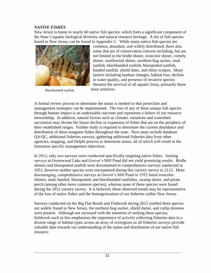
32
Blackbanded sunfish.
NATIVE FISHES
New Jersey is home to nearly 60 native fish species, which form a significant component of
the State’s aquatic biological diversity and natural resource heritage. A list of fish species
found in New Jersey can be found in Appendix C. While many native fish species are
common, abundant, and widely distributed, there also
some that are of conservation concern including, but are
not limited to the bridle shiner, ironcolor shiner, comely
shiner, swallowtail shiner, northern hog sucker, mud
sunfish, blackbanded sunfish, bluespotted sunfish,
banded sunfish, shield dater, and slimy sculpin. Many
factors including landuse changes, habitat loss, decline
in water quality, and presence of invasive species
threaten the survival of all aquatic biota, primarily those
most sensitive.
A formal review process to determine the status is needed so that protection and
management strategies can be implemented. The loss of any of these unique fish species
through human impact is an undesirable outcome and represents a failure of our resource
stewardship. In addition, natural factors such as climatic variations and watershed
succession may dictate the future decline or expansion of fishes that are on the periphery of
their established ranges. Further study is required to determine the current abundance and
distribution of these nongame fishes throughout the state. Next steps include database
QA/QC, additional fisheries surveys, gathering additional fisheries data from other
agencies, mapping, and Delphi process to determine status, all of which will result in the
formation specific management objectives.
In 2012, only two surveys were conducted specifically targeting native fishes. Seining
surveys at Greenwood Lake and Grover’s Mill Pond did not yield promising results. Bridle
shiners and bluespotted sunfish were documented in comprehensive surveys conducted in
1951, however neither species were encountered during this cursory survey in 2112. More
discouraging, comprehensive surveys at Grover’s Mill Pond in 1952 listed ironcolor
shiners, mud, banded, bluespotted, and blackbanded sunfishes, swamp darter, and pirate
perch (among other more common species), whereas none of these species were found
during the 2012 cursory survey. It is believed, these observed trends may be representative
of the loss of native fishes and the homogenization of our fisheries within New Jersey.
Surveys conducted on the Big Flat Brook and Flatbrook during 2012 yielded three species
not widely found in New Jersey, the northern hog sucker, shield darter, and cutlip minnow
were present. Although not surveyed with the intention of seeking these species,
fieldwork such as this emphasizes the importance of actively collecting fisheries data in a
diverse range of habitat types across an array of ecoregions as all fisheries surveys provide
valuable data towards our understanding of the status and distribution of our native fish
resource.

33
TROUT STOCKING PROGRAM: ALLOCATIONS
Annually, the Division of Fish & Wildlife’s Freshwater Fisheries Research and
Management Unit determines which waterbodies and how many trout per waterbody will
be stocked statewide. The allocation methodology uses a combination of biological,
physical, and social factors to equitably allocate trout over a 10-week period to all trout-
stocked waters. A computerized database containing different variables for each stream,
lake, and pond is used in conjunction with a formula to calculate individual weekly
allotments of trout. The database is annually reviewed and updated by biologists.
There were no changes to the Trout Formula methodology used to determine spring trout
allocations for 2012. We are continuing to use a spring baseline of 570,000 trout to
determine individual weekly allocations. A summary of trout stocked during 2012, by
season and species is found in Table 6.
Table 6. 2012 Trout stocking summary by season/program.
Spring 2012 Trout Stocking Summary
Species Type Avg. Length Lbs. # Fish
Rainbow Trout Production 11.2" 100,725 199,192
Broodstock 16.3" & 23.5 5,529 1,788
Brook Trout Production 11.1" 134,264 256,607
Broodstock 16.7" 5,982 2,410
Brown Trout Production 10.9" 86,558 157,895
Broodstock 16.5" & 21.9 7,938 2,370
Totals 340,996 620,262
Fall 2012 Trout Stocking Summary
Species Type Avg. Length Lbs. # Fish
Rainbow Trout Production 14.4" 13,826 9,190
Broodstock 22.0" 3,242 640
Brook Trout Production 14.8" 14,884 9,210
Brown Trout Production 13.7" 4,038 3,185
Totals 35,990 22,225
2012 Sea Run Brown Trout (Manasquan River)
Species Type Avg. Length Lbs. # Fish
Brown Trout surplus 8.2" 3,600 15,840
Winter 2012 Trout Stocked Lakes Program Summary
Species Type Avg. Length Lbs. # Fish
Rainbow Trout broodstock 15.0" 7,014 5,010
New waterbodies added to the trout stocking program in 2012 include Brookaloo Swamp
(name change only), Ponderlodge Pond, and South Vineland Park Pond. Giampetro Park
Pond will be stocked fewer times (pre-season only as opposed to pre-season and 3 in-
season stockings) due to the proximity of the recently added South Vineland Park Pond.
Waterbodies dropped in 2012 include Clarks Pond, Mullica Hill Pond, Riverview Beach
Pond, and Trout Brook (Hope). Stream mileage was updated in the trout formula for the

34
Wild brook trout marked with
Visual Implant Elastomer (VIE).
D&R Canal (Mercer Co.), Honey Run, Manasquan River, Rockaway Creek, Rockaway
River, Saddle River (below Annendale Road), and Stony Brook. The following lakes were
not stocked in 2012 due to ongoing construction projects Prospertown Lake, Blue
Mountain Lake, Blair Lake, Diamond Mill Pond, and Pohatcong Lake. Grenloch Lake was
not stocked due to a diesel spill that ran into the lake.
SPECIES MANAGEMENT
Species Management – Brook Trout
The Bureau of Freshwater Fisheries worked closely with Montclair State University
Department of Biology and Molecular Biology doctoral candidate Luke Diglio, as part of a
dissertation proposal, titled The Impact of Dam Removal Upon Population Dynamics of
Native Relict Brook Trout (Salvelinus fontinalis) and Exotic Brown Trout (Salmo trutta) in
the Headwaters of a Northern New Jersey Stream System. This study will provide not only
valuable information in regards to the status and distribution of brook trout and update New
Jersey’s Surface Water Quality Standards, but also a better understanding of this unique
brook trout metapopulation(s) and it’s interaction with brown trout once the dam is
removed, allowing for protection and enhancement of this and other similar fisheries.
An important component of is the Raritan River S/Br
Headwater Study. A series of electrofishing surveys
were conducted at many sites on the Raritan River
South Branch and on 10 of its tributaries in Morris
County during the summers of 2009 through 2012.
Brook trout were marked during the summers of 2010
and 2011 from 6 different streams with unique locations
and color combinations of Visible Implant Elastomers
(VIEs) as part of a mark / recapture study of brook trout
metapopulation dynamics (Table 7). During the
summer of 2010, 427 trout were marked. When
resampled the following winter, 346 trout were
captured, consisting of 48 previously marked fish (11%), found in their original stream,
while 5 marked fish (1%) were found in waters other than their original streams. During
the spring of 2011, 263 trout were collected, consisting of 28 marked fish, found in their
original stream, and 0 marked fish, found elsewhere. During the summer of 2011, 576
trout were captured, however only 1 marked trout was captured. Of the 501 trout, 337 were
marked with new color combinations to be recaptured in subsequent sampling events.
When resampled the following winter, 436 trout were captured, consisting of 57 previously
marked fish, found in their original stream, while 6 marked fish were found in waters other
than their original streams. Brook trout were marked (n=336) during the 2011 summer and
data collection efforts were replicated, starting the 2011 winter through the 2012 summer
Recapture results were nearly identical to those during the previous cycle. Upon
conclusion of the project, 195 of the 763 marked fish were recaptured. Of those, 173 were
found in the same waterbody and 22 were found in adjacent waterbodies (21 moved
between mainstem and the tributaries and 1 between tributaries). Initial findings indicate
high fidelity of brook trout to the same stream throughout sampling period (89%), however
some movement was documented (11%). This study provides information on

35
Table 7. Data for brook trout marked and recaptured during various seasons for Raritan River
S/Br Headwater Study using Visible Implant Elastomers (VIE).
Rar
itan
Riv
er
S/B
r
R.R
. S
/Br
(tri
b)
(SW
of
Bu
dd
Lak
e)
R.R
. S
/Br
(tri
b)
(N o
f
Dra
kes
tow
n)
R.R
. S
/Br
(tri
b)
(Dra
kes
tow
n)
R.R
. S
/Br
(tri
b)
(Dig
lio
Dit
ch)
Su
n V
alle
y
Bro
ok
R.R
. S
/Br
(tri
b)
(war
mw
ater
)
To
tal
Summer 2010 marked 84 100 100 100 35 6 0 427
Summer 2010 VIE color red yellow green yellow red green NA
Summer 2010 VIE location right right left left left right NA
*2 trout marked with green-left were found in the Raritan River S/Br during the 2010 marking period.
Winter recapture (all) 40 78 43 164 16 5 0 346
Winter recap. w/mark
from original stream
9
(11%)
10
(10%)
8
(8%)
14
(14%)
7
(20%) 0 0
48
(11%)
Winter recap. w/mark
from another stream
1 RL (3%)
1 YL (1%) 0 0
2 RR
(2%)
1 RR
(1%) 0 0
5
(1%)
Spring 2011 recap. (all) 18 67 52 116 4 6 0 263
Spring recap. w/mark
from original stream
2
(2%)
12
(12%)
7
(7%)
6
(6%)
1
(3%) 0 0
28
(7%)
Spring recap. w/mark
from another stream 0 0 0 0 0 0 0 0
Summer 2011 recapture (all) 3 178 105 180 31 4 0 501
Summer recap. w/mark
from original stream 0 0 0 0 0
1
(17%) 0
1
(0.2%)
Summer recap. w/mark
from another stream 0 0 0 0 0 0 0 0
Summer 2011 marked 3 100 100 100 30 3 0 336
Summer 2011 VIE color white blue purple blue white purple NA
Summer 2011 VIE location left left right right right left NA
Winter 2011 recapture (all) 34 112 56 204 29 1 0 436
Winter recap. w/mark
from original stream
1 WL (33%)
1 RR (1%)
14
(14%)
14
(14%)
21
(21%)
6
(20%) 0 0
56 (17%)
57 (2%)
Winter recap. w/mark
from another stream
1 PL (33%)
2 PR (2%)
2 BR (2%)
1 BL (2%)
0 0 0 0 0 0 6
(2%)
Spring 2012 recap. (all) 91 76 46 276 8 6 0 503
Spring recap. w/mark
from original stream 1 RR (1%)
4
(4%)
10
(10%)
7
(7%)
2
(7%) 0 0
24
(7%)
Spring recap. w/mark
from another stream
4PR (4%)
1PL (33%)
3WR 10%)
2BR (2%)
0 0 0 0 0 0 9
(3%)
Summer 2012 recapture (all) 17 57 66 385 12 4 2 543
Summer recap. w/mark
from original stream 0 1 (1%) 7 (7%) 7 (7%) 0 0 0
15
(4%)
Summer recap. w/mark
from another stream
1 WR
(3%) 0 0
1 PR
(1%) 0 0 0
2
(0.6%)

36
Largest lake trout (24.5 lbs.) captured in
Round Valley Reservoir in 2012.
metapopulation dynamics, specifically whether each population functions independently or
if there is a greater likelihood of gene flow between populations. The presence of a failing
dam on the South Branch, which will likely be removed, presents an interesting component
to the study. Wild brook trout are found both above and below the dam, whereas wild
brown trout are primarily found below dam.
Species Management – Lake Trout
Lake trout (Salvelinus namaycush) fisheries exist in two waterbodies within New Jersey,
Round Valley Reservoir and Merrill Creek Reservoir. Surplus lake trout have been stocked
into Monksville Reservoir since at least 2004, however it does not seem to have developed
into a significant fishery.
The lake trout population in Round Valley Reservoir is surveyed each fall by the Division
of Fish and Wildlife to evaluate the status of this trophy trout fishery. Lake trout reared at
the Hackettstown Hatchery were stocked in this deep reservoir (maximum depth 160 feet)
from 1977 until 1995. In 1985, evidence that natural reproduction was occurring within the
reservoir was documented. By 1995, it was determined that the population was capable of
maintaining itself by natural reproduction, thus stocking was discontinued. Gillnet surveys
are conducted every fall, when mature lake trout seek out suitable spawning habitat along
the boulders lining the reservoir’s dams. Eight experimental gillnets, each having three
different small mesh size openings, are used to capture a range of lake trout from juveniles
to sub-adults (yielded 85 lake trout in 2012). Eight large-mesh gillnets (6” stretch mesh)
are set near the reservoir’s north and south dams to capture mature adult lake trout as they
begin congregating to spawn over the rocky substrate (yielded 91 lake trout in 2012).
Length and weight information is collected to assess physical condition of the fish using
relative weight analysis. In addition, sex, finclips, and sexual development information are
also recorded.
Data indicate a stunted lake trout population with
an abundance of small fish (22 under 1 lb., 53
from 1 to 2 lbs., 75 from 2 and 3 lbs., 22 from 3
to just over 4 lbs., 3 from 9 to 12 lbs., and the
largest at 24.5 lbs. (38.8 inches)). The total
number of lake trout captured was 176. Data
will be analyzed and compared to previous years.
In an effort to further liberalize the take of lake
trout, a new regulation was adopted by the Fish
and Game Council and went go into effect in
2012. This regulation allows the harvest of 6
lake trout from 15 inches to less than 24 inches
and one additional lake trout 24 inches or
greater.
Lake trout have been stocked annually at Merrill Creek Reservoir since 1988, when it
first filled with water following construction. The reservoir’s fishery is managed by the
Merrill Creek Owners Group in cooperation with Fish and Wildlife. Fisheries surveys are
conducted annually at this 650-acre reservoir by the owner’s consultant to monitor lake

37
Largest lake trout (11.4 lbs.) captured
in Merrill Creek Reservoir in 2012.
trout and other fish species inhabiting the reservoir. This year's annual survey of the
Merrill Creek Reservoir lake trout fishery was completed in early December. Gill nets
were used to capture lake trout of varying size and age. A total of 35 lake trout were
captured and ranged from 10.8 – 30.7 inches, with the largest weighing 11.4 pounds. This
data, along with survey data from recent years,
provide mounting evidence that lake trout are
successfully reproducing in the reservoir and indicate
that stocking may no longer be necessary in order to
maintain this fishery. Therefore, the number of lake
trout stocked in 2012 was reduced by 60%, and
stocking of this species will be discontinued in the
future. The reservoir’s fishery and natural
reproduction of lake trout will continue to be
monitored to assess the status of the fishery.
Species Management – Trout
Temperature data loggers were installed at three locations in the Big Flat Brook/Flat
Brook special regulation area to monitor and record summer water temperature, at half-
hour intervals, over a 45-day period (July 26 – September 8). The daily maximum water
temperatures exceeded the desirable limit for trout (21°C (69.8°F)) on 13 – 23 days
(depending on location). This temperature data will complement electrofishing data and
angler survey information to not only assess the current fishing regulations, but also will
aid managers and stakeholders in determining if regulation changes would benefit the
fishery.
Angler logbooks were developed, assembled, and distributed to anglers who frequently
fish the Year Round Trout Conservation Areas on the Musconetcong River and S/Br.
Raritan River, and the special regulation area on the Big Flat Brook. Anglers recorded
pertinent information related to their fishing trip (start and stop times, fishing location,
number of fish caught, fish harvested, etc.) in the logbooks and returned them at the end of
the calendar year (or sooner if done fishing for the year). The data from returned logbooks
will be compiled and analyzed early in 2013. Results will be used to make fisheries
management decisions related to trout stocking and fishing regulations in these special
regulation areas.
Opening day angler counts and creel surveys are conducted annually, utilizing a network
of Wildlife Conservation Corps (WCC) volunteers, assigned to various trout stocked
waters. The surveys have two main objectives: (1) to record angler turnout on specific
waterbodies and (2) to determine angler success. A complete list of angler turnout and
catch data at the 25 lakes and ponds and 9 rivers and streams is found in Table 8.
The Bureau utilized the opening day angler counts and creek survey, to institute a pilot
project, in which eight waterbodies were stocked during the pre-season with 50% of both
brook and rainbow trout, rather than the traditional 100% brook trout, to evaluate species

38
Table 8: Opening Day angler counts and total trout caught on all waterbodies surveyed
from 8:00am to 12:00pm, sorted by total number of trout caught.
County Waterbody
Bonus
Broodstock
Stocked in
2012
Highest # of
anglers in
any given
hour
Total # of
Trout
Caught
Warren
Musconetcong River
(Stephens State Park)
74 390
Cape May Ponderlodge X 150 134
Hunterdon Manny's Pond X 102 115
Union Seeley's Pond X 67 91
Cumberland Shaws Mill Pond 86 73
Hunterdon Mountain Farm Pond 31 73
Hunterdon Musconetcong R. Point Mtn. 19 72
Passaic Barbour's Pond X 107 65
Middlesex Farrington Lake 34 64
Burlington Crystal Lake X 116 55
Union Rahway River 70 54
Sussex Lake Ocquittunk 62 52
Cumberland Cohansey River 17 52
Bergen Dahnert's Lake 74 47
Cumberland South Vineland Park Pond X 43 41
Hunterdon Amwell Lake 36 41
Essex Verona Park Lake X 182 40
Cape May Tuckahoe Lake 32 38
Monmouth Echo Lake X 91 35
Monmouth Englishtown Mill Pond 32 27
Morris India Brook 20 26
Camden Gloucester City Pond 22 26
Hunterdon S/Br. Raritan River - Gorge 34 24
Middlesex Roosevelt Park Pond 64 22
Atlantic Birch Grove Park Pond 110 16
Cumberland Giampietro Park Pond 44 14
Cumberland Mary Elmer Lake 32 10
Morris Burnham Park Pond 37 10
Monmouth Holmdel Park Pond X 47 9
Middlesex Lake Papaianni 27 8
Union Green Brook 12 6
Passaic Clinton Reservoir 47 1
Warren Trout Brook - Hackettstown 0 0
Sussex Flatbrook 48 not
recorded
Note: Not all anglers that were counted were interviewed.

39
“cooperation” during the initial opening of the 2012 trout season. Assuming angler
identification was accurate, the survey indicates anglers were more successful catching
rainbow trout overall (257 rainbow trout compared to 102 brook trout) and on all
waterbodies, except Amwell Lake (Table 9). The Bureau has intentions of expanding this
pilot project to help guide its stocking program.
Table 9. Eight waterbodies stocked with 50% rainbow and 50% brook trout and results.
8 Waterbodies Anglers Rainbow
Trout
Brook
Trout
Total
Caught
Trout
caught per
angler
Rainbow
to Brook
ratio
Dahnert's Lake 62 39 6 45 0.73 6.5
Roosevelt Park Pond 43 11 4 15 0.35 2.8
Verona Park Pond 160 31 16 47 0.29 1.9
Amwell Lake 26 15 23 38 1.46 0.7
Barbour’s Pond 98 52 0 52 0.53 52 to0
Burnham Park Pond 20 13 1 14 0.70 13.0
Lake Ocquittunk 30 31 20 51 1.70 1.6
Seeley's Pond 47 45 22 67 1.43 2.0
Totals 486 237 92 329 0.68 2.6
Species Management – Largemouth and Smallmouth Bass
Increasing angler demand for quality largemouth bass fisheries and the recent confirmation
of largemouth bass virus in New Jersey has elevated the need to establish more active bass
management techniques. Fourteen waterbodies were sampled for large and smallmouth
bass in 2012 (Table 10). Several waters, including Lakes Audrey, Parvin Lake, and Salem
Canal are sampled regularly, with recent management plans. Others such as Grenloch Lake
and Bostwick Lake have not been sampled for over ten years.
Supplemental stockings of largemouth bass in Union Lake have
helped to reverse the effects of largemouth bass virus. Stocking
smallmouth bass in Union Lake and Lake Audrey have provided
South Jersey anglers with new fishing opportunities that were once
only available in North Jersey. Though sampling efforts on the
Delaware River and its tributaries were focused on invasive species,
valuable bass data was collected while electrofishing. Extensive
submerged aquatic vegetation throughout the lower tidal Delaware
has increased habitat for both largemouth and smallmouth bass.
Both species were well represented and were in good condition.
A number of waters were stocked with largemouth and smallmouth bass in 2012.
Waterbodies that were sampled in recent years, those that had dam replacements and those
that have been affected by largemouth bass virus were stocked with 2” fingerlings raised at
Hackettstown Hatchery. Lakes with developing smallmouth bass populations were also
stocked including Lake Audrey and Spruce Run Reservoir.

40
Table 10. List of waters sampled in central and southern New Jersey for
largemouth and smallmouth bass.
2012 Waters Sampled for Bass County Sampling Method
Bostwick Lake Cumberland Electrofishing Boat
Cohansey River Cumberland Electrofishing Boat
Daretown Lake Cumberland 20’ Seine
Davis Millpond Cumberland Electrofishing Boat
Glenn Lake Gloucester 20’ Seine
Grenloch Lake Gloucester Electrofishing Boat
Grenloch Lake Gloucester 20’ Seine
Heritage Park Pond Atlantic 20’ Seine
Lake Audrey Cumberland Electrofishing Boat
Lake Audrey Cumberland 20’ Seine
Maple Lake Atlantic Electrofishing Boat
Mary Elmer Lake Cumberland 20’ Seine
Patriot Lake Atlantic 20’ Seine
Parvin Lake Cumberland Electrofishing Boat
General Warmwater Assessment of Lakes and Ponds
The Bureau conducts abbreviated fisheries surveys on lakes and ponds throughout the State
to assess their status. This becomes more necessary following an event that may have
impacted the fishery such as the draining of a lake or in response to a report of poor angling
conditions. Six field investigations were conducted by Bureau of Freshwater Fisheries
staff.
Best Lake (Somerset)
Shoreline seining was conducted at this 6-acre lake to assess the existing fish population,
several years after the lake was drained in 2008 for a dam repair. At that time, a fish
habitat project was implemented and warmwater fish were stocked in 2009 and 2010.
Seining data indicate extensive sunfish (primarily bluegill) reproduction is taking place as
hundreds of young-of-the-year were collected with nearly every seine haul. Few
largemouth bass were encountered, so 50 averaging 4.5 inches were stocked by the
Hackettstown Fish Hatchery in an attempt to balance the fishery. Unfortunately, green
sunfish and mosquitofish were also abundant. It is recommended that additional surveys
are conducted to monitor the fish population.
Franklin Pond (Sussex)
Shoreline seining was conducted at Franklin Pond to assess warmwater fish reproduction.
Although sunfishes (primarily bluegill) were abundant, largemouth bass (young-of-the-
year) were scarce. Stocking recommendations were submitted to the Hackettstown Fish
Hatchery.
Grover’s Mill Pond (Mercer)
Shoreline seining was conducted at this 28-acre lake to assess the existing fish population,
several years after the lake was partially lowered in 2008 for dredging. An assortment of
warmwater species were stocked in 2009 to bolster the fish population. Seining data

41
indicate adequate sunfish (primarily bluegill), largemouth bass, and black crappie
reproduction is taking place. Unfortunately, many of the native species once found in this
waterbody are no longer present.
Manalapan Lake (Middlesex)
Shoreline seining was conducted at this 40-acre lake to assess the existing fish population.
Within the last few years the Township of Monroe and Middlesex County have
demonstrated interest to improve the fishery and angler access of this waterbody and the
Division of Fish and Wildlife supports recent actions they have taken. Seining data
indicate adequate sunfish (primarily bluegill) and largemouth bass reproduction is taking
place. This information will be useful when determining next steps in the management of
this waterbody. An assortment of fish (325 crappie, 100 adult bluegill and 300 yoy, 17
brown bullhead, 35 yellow bullhead, 15 largemouth bass, 5 chain pickerel, 25 shiners) were
salvaged from Brainerd Lake (Middlesex) due to a dam failure and relocated to Manalapan
Lake to bolster the fish population.
Nelson Lake (Middlesex)
Shoreline seining was conducted at this 15-acre lake to assess the existing fish population,
several years after the lake was drained in 2010 for a dam repair. An assortment of
warmwater fish were stocked in 2011. Seining data indicate adequate sunfish (primarily
bluegill) reproduction is taking place, however no young-of-the-year largemouth bass were
encountered, however this does not warrant concern, as the largemouth bass stocked in
2011 were only 1.5 to 2 inches and would not be of age to have experienced a spawing
season. To bolster the bass population, 375 largemouths, averaging 4.5 inches, were
stocked by the Hackettstown Fish Hatchery. Unfortunately, mosquitofish were present. It
is recommended that additional surveys are conducted to monitor the fish population.
Watchung Lake (Somerset)
Shoreline seining was conducted at this 15-acre lake to assess the existing fish population.
Fish salvaged from the Best Lake, which is in very close proximity, were relocated into
Watchung Lake in 2008. Seining data indicate sunfish (primarily bluegill) reproduction is
taking place, however surprizingly no largemouth bass were encountered. As a result, 300
largemouth bass, averaging 4.5 inches, were stocked by the Hackettstown Fish Hatchery in
an attempt to balance the fishery. Unfortunately, green sunfish were present. It is
recommended that additional surveys are conducted to monitor the fish population.
FISH SALVAGES
Permitted fish salvages are necessary under a variety of circumstances, such as substantial
water lowering events related to projects such as the dredging of a lake or a the repair of a
dam. These salvages are typically conducted by trained private aquatic consultants and are
conducted under controlled circumstances, during the more favorable conditions
encountered in the fall and can be a relatively simple exercise. On the other hand, every
year, as the result of a catastrophic dam failure or merely a minor leak, compounded with
increased water temperatures and diminished oxygen levels during the summer, countless
fish are threatened with demise. During emergency situations on State owned property
such as Wildlife Management Areas or those managed by the Division of Parks and
Forestry, the Bureau of Freshwater Fisheries may mobilize to conduct fish salvages to

42
rescue fish and relocate them to suitable waters. In 2012, the Bureau conducted one fish
salvage:
Brainerd Lake (Middlesex)
An emergency fish salvage was conducted on August 24 due to a breach in the Brainerd
Lake dam. Fishes relocated to Manalapan Lake include 325 crappie, 100 adult bluegill and
300 young-of-the-year bluegill, 17 brown bullheads, 35 yellow bullheads, 15 largemouth
bass, 5 chain pickerel, and 25 golden shiners. It is assumed that a number of fish escaped
downstream into Cranbury Brook.
HABITAT RESTORATION and TECHNICAL ASSISTANCE
In order to protect New Jersey’s critical aquatic resources fisheries biologists provide input
on a number of land use projects each year. Coordinated through the Division’s Bureau of
Environmental Review, this input is directed towards minimizing land use change impacts
on state’s fisheries resources. This is typically accomplished through the use of timing
restrictions during critical fish spawning periods, protection of riparian buffers, and project
modification, assuring best use practices are implemented at all times. However, at times a
more in depth review and comments are necessary on specific projects.
In 2012, staff also provided technical assistance related to stream restoration and dam
removal projects, as described below.
Mason’s Run (Camden County)
Mason’s Run supports the southernmost reproducing brook trout population in New Jersey.
The Pine Hill Golf Course was constructed in the late 90’s, in which parts of the course
actual traverse this unique South Jersey resource. During construction in 1999, a large
sedimentation event impacted the stream and trout population. Sediment was removed by
Jim Gracie of Brightwater Environmental Consulting and the stream and trout population
rebounded. In recent years, sedimentation from road run off, golf course input and unstable
upstream habitat created heavy deposition of sediment in Mason’s Runs. These issues and
others were discussed at the Pine Hill Conservation Team annual meetings and a consultant
was hired to draft a proposed restoration project which could be implemented in
2012/2013.
In 2012, a large sedimentation event was discovered at
Mason’s Run, on August 6th by a member of the
Conservation Team and active Trout Unlimited member
Brian Burns. The course staff indicated that on July 20th a
lightning strike caused a failure of the irrigation system
which in turn caused an undetermined amount of water and
sand to enter the stream. This catastrophic event threatened
this already impacted trout stream.
A sight visit by the members of the conservation group
determined that approximately 150 meters of stream were
affect by heavy sediment deposits. NJDEP Compliance and
Enforcement, Trent Todash was on site on 8/15 to determine

43
if any enforcement action was required, no action was taken. Stream restoration experts
were consulted and indicated that immediate removal of the sediment is recommended.
Volunteers, conservation group representatives, golf course staff and Division employees
spent 14 days in the stream to remove the sediment via filling sand bags. Approximately
1465 sandbags were removed from the stream. The sand bags weighed approximately 50
pounds each and 36 tons total.
Further investigations by staff and trout unlimited member indicate that the brook trout
were able to successfully spawn this year. Components of the proposed restoration project
will be implemented in the future to address sedimentation issues.
Big Flatbrook (Sussex County)
Under the direction of Fish and Wildlife, a large woody debris jam on the Big Flat Brook,
in the Flatbrook-Roy WMA, was removed by a private contractor. Numerous trees had
lodged in a bend of the stream in 2011 (during hurricane Irene and tropical storm Lee)
causing much of the flow to be diverted into the adjacent wooded floodplain. Many of the
trees (30 estimated, 1-2 feet in diameter, with root-wads attached) were wedged across the
stream, with smaller woody debris lodged in-between. Biologists were present to supervise
this project and ensure that fish and wildlife resources were adequately protected. Fish
inhabiting side channels that would be dewatered were captured by electrofishing and were
relocated to the mainstem downstream of the log jam. A large snapping turtle was
relocated and a beaver and opossum moved out on their own accord. A beaver dam across
this prime trout stream would have had serious consequences for the trout, in terms of
thermal warming during the summer (from water impounded behind a beaver dam). This
one-day project was performed by a private contractor and funded by the Fred Burroughs
North Jersey Chapter of Trout Unlimited.
Impeded flow of the Big Flatbrook during woody debris removal (left) and restored flow via the main
channel following debris removal after (right).

44
Lower Muscontecong River Restoration Partnership
The Bureau actively participates in this Partnership, comprised of state and federal agencies
(NJDEP, NRCS, NOAA, USFWS, NPS), and nonprofit organizations (Musconetcong
Watershed Association, Trout Unlimited, American Rivers, and North Jersey RC&D).
This group works with willing dam owners and obtains grants for dam removals to improve
the health of the river and restore pathways for migratory fishes. In 2012 the Partnership
began focusing on the removal of the Hughsville and Warren Glen dams and the Army
Corps of Engineers continued to pursue removal of the Bloomsbury dam.

45
2012
SUMMARY
STREAM SURVEY DATA
This section of the report includes stream survey data completed by the Bureau of Freshwater
Fisheries in 2012. All surveys, unless specifically noted otherwise, are sampled in accordance to
the Bureau’s established stream sampling protocol which is consistent with EPA’s Rapid
Bioassement Protocol for Wadeable Streams. The Bureau’s wadeable stream survey protocol
can be found in Appendix A. The Bureau also assesses in-stream and riparian conditions by
performing a Habitat Assessment at the time of each survey. This assessment is consistent with
the EPA Rapid Bioassessment sampling habitat assessment protocol with regional modifications
(Appendix B). Basic water quality parameters are also measured.
Surveys are listed alphabetically by stream name within identified watershed areas. Each survey
is identified by the specific project by which it was funded. It is important to note, however, the
use of established stream sampling protocols permits data to be used beyond the specific project
for which they were collected. Data provided for the purposes of this report is only a summary
of the individual stream survey data collected by the DFW’s Bureau of Freshwater Fisheries.
All stream data collected under the Bureau’s standardized sampling protocol is entered into the
Division’s FishTrack database.

46
Surveys in the Upper Delaware River Basin
BIG FLAT BROOK
Summary
This survey is one of four conducted in 2012 on the 4.1 mile special regulation area on the Big
Flat Brook/Flat Brook (fly fishing only for all or most of the year). The survey station is located
a short distance upstream from its confluence with the Little Flat Brook and is also upstream of
the stream section known as the Blewett Tract. Two backpacks were used to electrofish this
stream reach. Trout and other fish species commonly found with trout were present (14 species
total). The seven brook trout encountered were all wild, naturally reproduced fish while the lone
rainbow trout was a stocked fish of hatchery origin (wild vs. hatchery based upon fin erosion and
wear). Although this stream section is classified as trout production, no young-of-the-year trout
were found and limited numbers of older trout were present despite the presence of optimal
physical habitat.
Recommendation: The data from the four electrofishing surveys, along with continuous water
temperature and angler survey data, will be used to assess the fishery and the special fishing
regulations to determine if regulation changes are warranted.
Project: Species Management Drainage: Flat Brook
Location: Blewett tract - upstream from (Sta #1) County: Sussex
Date: July 30, 2012 Municipality: Sandyston Twp.
Water Chemistry & Habitat
Water temperature 19.1°C
Dissolved oxygen 9.79 mg/L
pH 7.32
Alkalinity 24.5 mg/L as CaCO3
Specific conductance 91.9 S/cm
Sample length 150 m
Habitat assessment score 184 (optimal)
Fish species Number
sea lamprey 12
American eel 8
cutlip minnow 3
common shiner 30
blacknose dace 12
longnose dace 6
creek chub 12
fallfish 1
white sucker 4
redfin pickerel 3
rainbow trout (older than y-o-y) 1 (284 mm)
brook trout (older than y-o-y) 7 (156-294 mm)
pumpkinseed 1
tessellated darter 9

47
BIG FLAT BROOK
Summary
This survey is one of four conducted in 2012 on the 4.1 mile special regulation area on the Big
Flat Brook/Flat Brook (fly fishing only for all or most of the year). The survey station is located
a short distance upstream from its confluence with the Little Flat Brook and is also upstream of
the stream section known as the Blewett Tract. Two backpacks were used to electrofish this
stream reach. Trout and other fish species commonly found with trout were present (16 species
total). The three brook trout encountered were all wild, naturally reproduced fish (based upon
fin erosion and wear). Two species not widely found in New Jersey (northern hog sucker and
shield darter) were present. Although this stream section is classified as trout production, no
young-of-the-year trout were found and limited numbers of older trout were present despite the
presence of optimal physical habitat.
Recommendation: The data from the four electrofishing surveys, along with continuous water
temperature and angler survey data, will be used to assess the fishery and the special fishing
regulations to determine if regulation changes are warranted.
Project: Species Management Drainage: Flat Brook
Location: Upstream from Blewett tract (Sta #2) County: Sussex
Date: July 30, 2012 Municipality: Sandyston Twp.
Water Chemistry & Habitat
Water temperature 20.8°C
Dissolved oxygen 9.05 mg/L
pH 7.21
Alkalinity 23.5 mg/L as CaCO3
Specific conductance 91.9 S/cm
Sample length 150 m
Habitat assessment score 190 (optimal)
Fish species Number
sea lamprey 4
American eel 10
cutlip minnow 3
common shiner 24
blacknose dace 38
longnose dace 11
creek chub 1
fallfish 1
white sucker 15
northern hog sucker 5
margined madtom 1
redfin pickerel 3
brook trout (older than y-o-y) 3 (159-252 mm)
slimy sculpin 1
tessellated darter 16
shield darter 1

48
BIG FLAT BROOK
Summary
This survey is one of four conducted in 2012 on the 4.1 mile special regulation area on the Big
Flat Brook/Flat Brook (fly fishing only for all or most of the year). The survey station is located
in the upper end of this special regulation area. Two backpacks and a two-electrode stream rig
were used to electrofish the stream reach. Trout and other fish species commonly found with
trout were present (15 species total). The three trout (one rainbow and two brown) were stocked
fish of hatchery origin (wild vs. hatchery based upon fin erosion and wear). In addition to the
ubiquitous white sucker, the uncommon northern hog sucker was also present. Although
classified as trout production, this stream section yielded no young-of-the-year trout and a
limited number of older trout despite the presence of optimal physical habitat. The size of the
pools (deep and wide) hampered sampling efficiency.
Recommendation: The data from the four electrofishing surveys, along with continuous water
temperature and angler survey data, will be used to assess the fishery and the special fishing
regulations to determine if regulation changes are warranted.
Project: Species Management Drainage: Flat Brook
Location: Between Rt. 206 and Rt. 560 bridges County: Sussex
Date: July 31, 2012 Municipality: Sandyston Twp.
Water Chemistry & Habitat
Water temperature 19.9°C
Dissolved oxygen 9.24 mg/L
pH 7.62
Alkalinity 26.0 mg/L as CaCO3
Specific conductance 91.1 S/cm
Sample length 150 m
Habitat assessment score 174 (optimal)
Fish species Number
sea lamprey 1
American eel 54
cutlip minnow 11
common shiner 16
blacknose dace 197
longnose dace 42
creek chub 12
white sucker 28
northern hog sucker 2
rainbow trout (older than y-o-y) 1 (266 mm)
brown trout (older than y-o-y) 2 (242-288 mm)
slimy sculpin 37
pumpkinseed 5
largemouth bass 14
tessellated darter 16

49
FLAT BROOK
Summary
This survey is one of four conducted in 2012 on the 4.1 mile special regulation area on the Big
Flat Brook/Flat Brook (fly fishing only for all or most of the year). The survey station is located
in the lower end of this special regulation area. Two backpacks and a two-electrode stream rig
were used to electrofish the stream reach. Trout and other fish species commonly found with
trout were present (14 species total). Six trout representing three species were present and two of
the fish (the brook trout and a 114 mm brown trout) appeared to be of wild origin (based upon
fin erosion and wear). A limited number of trout were present, despite the presence of optimal
physical habitat. The width of the stream may have affected sampling efficiency.
Recommendation: The data from the four electrofishing surveys, along with continuous water
temperature and angler survey data, will be used to assess the fishery and the special fishing
regulations to determine if regulation changes are warranted.
Project: Species Management Drainage: Flat Brook
Location: Upstream from Roy Bridge County: Sussex
Date: July 31, 2012 Municipality: Sandyston Twp.
Water Chemistry & Habitat
Water temperature 18.8°C
Dissolved oxygen 10.03 mg/L
pH 7.66
Alkalinity 72.0 mg/L as CaCO3
Specific conductance 216.2 S/cm
Sample length 150 m
Habitat assessment score 170 (optimal)
Fish species Number
American eel 43
cutlip minnow 12
blacknose dace 57
longnose dace 35
creek chub 9
white sucker 27
redfin pickerel 1
rainbow trout (older than y-o-y) 2 (308-314 mm)
brown trout (older than y-o-y) 2 (284-296 mm)
brown trout (y-o-y) 1 (114 mm)
brook trout (older than y-o-y) 1 (180 mm)
slimy sculpin 13
pumpkinseed 74
tessellated darter 36
shield darter 1

50
HAKIHOKAKE CREEK (trib.) (Wydner)
Summary
A reproducing wild brown trout population, previously documented in 1990, was thriving in this
spring feed tributary which flows through farmland. Over a 150 m stream reach 178 brown trout
(110 young-of-the-year, 68 older than y-o-y) were encountered. The abundance of slimy sculpin
(102) reflects clean water and cold year-round temperatures. This is a very productive, small
trout stream due in large part to cold summer water temperatures and the high alkalinity. This
tributary is also stocked with trout in the spring (as part of the mainstem Hakihokake Creek) at
several locations downstream of the survey location. Given the presence of wild brown trout, it
may not be necessary to stock trout in this tributary to maintain a desirable trout fishery.
Recommendation: Additional assessments of both fish assemblages and angler usage at
locations downstream of the 2012 survey location would aid managers in determining if trout
stocking should be discontinued. Continue to monitor this stream in accordance with the
established schedule (every 20 years).
Project: Trout Production Inventory Drainage: Lockatong
Location: Rte 614, House #241 near pond by house off County: Hunterdon
dirt lane with culvert. Sampled between two
culverts.
Date: July 26, 2012 Municipality: Holland Twp.
Water Chemistry & Habitat
Water temperature 15.8°C
Dissolved oxygen 10.47 mg/L
pH 6.89
Alkalinity 155 mg/L as CaCO3
Specific conductance 304.2 S/cm
Sample length 150 m
Habitat assessment score 157 (suboptimal)
Fish species Number
American eel 2
blacknose dace 28
creek chub 1
brown trout (y-o-y) 110 (61-115 mm)
brown trout (older than y-o-y) 68 (126-296 mm)
slimy sculpin 102

51
Surveys in the Passaic River Basin
APSHAWA BROOK
Summary
This previously unsampled trout production catchment was investigated to determine the
presence of brook trout for the EBTJV. No trout were collected in the 50 meter stretch. Low
water and minimal flow were documented.
Recommendation: No need to sample again.
Project: Brook Trout Assessment Drainage: Pequannock River
Location: At Mt. Springs Road, West Bridge Crossing County: Passaic
Date: July 18, 2012 Municipality: West Milford
Water Chemistry & Habitat
Water temperature 23.4°C
Dissolved oxygen 6.08 mg/L
pH 7.42
Alkalinity 90.0 mg/L as CaCO3
Specific conductance 444.1 S/cm
Sample length 50 m
Habitat assessment score -
Fish species Number
creek chub 27
chain pickerel 1
pumpkinseed sunfish 1
NON-STANDARDIZED SURVEY

52
BEAR SWAMP BROOK
Summary
Conducted electrofishing on a 50 meter stretch of Bear Swamp Brook, upstream of Bear Swamp
Lake in the Ramapo Reservation, Bergen County. A natural gas pipeline is slated to cross the
brook at this point. The sampling was conducted to determine the presence, or absence, of native
brook trout which inhabit this brook below Bear Swamp Lake. Two mudminnows and no brook
trout were collected.
Recommendation: No need to sample again.
Project: Stream Encroachment Review Drainage: Ramapo River
Location: Above Bear Swamp Lake; Ramapo Valley County: Bergen
Reservation (Lower Site)
Date: September 20, 2012 Municipality: Mahwah Twp.
Water Chemistry & Habitat
Water temperature 13.5°C
Dissolved oxygen 9.11 mg/L
pH 7.01
Alkalinity -
Specific conductance 89.1 S/cm
Sample length 50 m
Habitat assessment score -
Fish species Number
eastern mudminnow 2
NON-STANDARDIZED SURVEY

53
BEAR SWAMP BROOK
Summary
Conducted electrofishing on a 50 meter stretch of Bear Swamp Brook, upstream of Bear Swamp
Lake in the Ramapo Reservation, Bergen County. A natural gas pipeline is slated to cross the
brook at this point. The sampling was conducted to determine the presence, or absence, of native
brook trout which inhabit this brook below Bear Swamp Lake. Two mudminnows and no brook
trout were collected.
Recommendation: No need to sample again.
Project: Stream Encroachment Review Drainage: Ramapo River
Location: Above Bear Swamp Lake; Ramapo Valley County: Bergen
Reservation (Upper Site)
Date: September 20, 2012 Municipality: Mahwah Twp.
Water Chemistry & Habitat
Water temperature 14.1°C
Dissolved oxygen 9.28 mg/L
pH 6.81
Alkalinity -
Specific conductance 91.2 S/cm
Sample length 50 m
Habitat assessment score -
Fish species Number
eastern mudminnow 2
NON-STANDARDIZED SURVEY

54
DEN BROOK
Summary
This previously unsampled trout production catchment was investigated to determine the
presence of brook trout for the EBTJV. No trout were collected in the 50 meter stretch.
Recommendation: No need to sample again.
Project: Brook Trout Assessment Drainage: Passaic River
Location: Below Radtke Road County: Morris
Date: August 2, 2012 Municipality: Randolph
Water Chemistry & Habitat
Water temperature 20.3°C
Dissolved oxygen 7.30 mg/L
pH 7.04
Alkalinity 20.0 mg/L as CaCO3
Specific conductance 520.4 S/cm
Sample length 50 m
Habitat assessment score -
Fish species Number
blacknose dace 7
creek chub 33
NON-STANDARDIZED SURVEY

55
GREEN POND BROOK
Summary
Classified as trout production, this brook was first sampled by the USF&WS in 1987. At that
time a reproducing brook trout population was present (3 young-of-the-year (yoy) and 7 older
fish) along with rainbow trout (1), eastern mud minnow (14), and chain pickerel (2) were
collected over 183 m. In 2012 a total of 14 brook trout were collected (12 yoy and 7 older fish)
and no other fish were collected. Five additional yoy brook trout were observed but eluded
capture. The largest brook trout captured was only 106 mm and the absence of larger adult
brook trout in the survey is cause for concern. Perhaps older year classes of brook trout are
prevalent upstream and downstream of the survey location. A perched culvert downstream is
likely a barrier to upstream fish passage and the gorge upstream may also affect the movement of
fish in this stream.
Recommendation: Continue to monitor the stream in accordance with the established schedule
(a minimum of once every 20 years). The perched culvert should be removed or replaced with a
structure that does not obstruct fish passage and fragment the stream. This possibility should be
further explored with the property owner.
Project: Trout Production Inventory Drainage: Rockaway River
Location: At Picatinny Arsenal, 122 slug butt area County: Morris
Date: August 30, 2012 Municipality: Picatinny Arsenal
Water Chemistry & Habitat
Water temperature 19.5°C
Dissolved oxygen 8.03 mg/L
pH 6.99
Alkalinity -
Specific conductance 51.7 S/cm
Sample length 150 m
Habitat assessment score 139 (suboptimal)
Fish species Number
brook trout (y-o-y)
brook trout
12 (67-88 mm)
2 (102-106 mm)

56
MACOPIN RIVER (trib.) (Unnamed Tributary #1)
Summary
This previously unsampled trout production catchment was investigated to determine the
presence of brook trout for the EBTJV. This stream was not electrofished due to low dissolved
oxygen. The habitat was very swampy and the water was turbid and had no observable flow.
Recommendation: No need to sample again.
Project: Brook Trout Assessment Drainage: Pequannock River
Location: Echo Lake Road Bridge Crossing @ County: Passaic
Macopin Road Intersection
Date: July 18, 2012 Municipality: West Milford
Water Chemistry & Habitat
Water temperature 20.2°C
Dissolved oxygen 1.23 mg/L
pH 6.73
Alkalinity -
Specific conductance 1651 S/cm
Sample length 0
Habitat assessment score -
Fish species Number
No fish collected
NON-STANDARDIZED SURVEY

57
MILL BROOK
Summary
This previously un-sampled trout production catchment was investigated to determine the
presence of brook trout for the EBTJV. No trout were collected in the 50 meter stretch.
Recommendation: No need to sample again.
Project: Brook Trout Assessment Drainage: Passaic River
Location: Morris County Community College County: Morris
Date: August 2, 2012 Municipality: Randolph
Water Chemistry & Habitat
Water temperature 20.6°C
Dissolved oxygen 6.66 mg/L
pH 6.72
Alkalinity 35.0 mg/L as CaCO3
Specific conductance 532.1 S/cm
Sample length 50 m
Habitat assessment score -
Fish species Number
blacknose dace 4
creek chub 4
white sucker 1
largemouth bass 1
NON-STANDARDIZED SURVEY

58
MILL BROOK (trib.) (Unnamed tributary #1)
Summary
This previously unsampled trout production catchment was investigated to determine the
presence of brook trout for the EBTJV. One adult brown trout was collected in the 50 meter
stretch. Mill Brook is classified as trout production for brown & brook trout
Recommendation: No need to sample again.
Project: Brook Trout Assessment Drainage: Passaic River
Location: Upstream of Wilkshire Road County: Morris
Date: August 2, 2012 Municipality: Randolph
Water Chemistry & Habitat
Water temperature 21.4°C
Dissolved oxygen 7.14 mg/L
pH 7.14
Alkalinity NA
Specific conductance 272.8 S/cm
Sample length 50 m
Habitat assessment score -
Fish species Number
blacknose dace 24
brown trout (older than y-o-y) 1 (241 mm)
NON-STANDARDIZED SURVEY

59
PASSAIC RIVER (Site #1)
Summary
This previously unsampled trout production catchment was investigated to determine the
presence of brook trout for the EBTJV. Eleven brown trout, including seven young-of-the-year
(yoy), and six rainbow trout, including 5 yoy, were collected in the 50 meter stretch. The
presence of native brown & rainbow trout is consistent with previous sampling conducted above
and below this site.
Recommendation: No need to sample again.
Project: Brook Trout Assessment Drainage: Passaic River
Location: Below confluence with Indian Grove Brook County: Morris
Date: July 25, 2012 Municipality: Basking Ridge
Water Chemistry & Habitat
Water temperature 20.5°C
Dissolved oxygen 8.80 mg/L
pH 7.22
Alkalinity 57.0 mg/L as CaCO3
Specific conductance 245.2 S/cm
Sample length 50 m
Habitat assessment score -
Fish species Number
common shiner 2
spottail shiner 1
blacknose dace 6
longnose dace 3
creek chub 6
white sucker 5
rainbow trout (y-o-y) 5 (59-72mm)
rainbow trout (older than y-o-y) 1 (292mm)
brown trout (y-o-y) 7 (54-89mm)
brown trout (older than y-o-y) 4 (184-271mm)
tessellated darter 7
NON-STANDARDIZED SURVEY

60
PASSAIC RIVER (Site #2)
Summary
This previously unsampled trout production catchment was investigated to determine the
presence of brook trout for the EBTJV. No fish were collected in the 30 meter stretch. Only
crayfish were observed.
Recommendation: No need to sample again.
Project: Brook Trout Assessment Drainage: Passaic River
Location: 54 Tempe Wick Road County: Morris
Date: July 25, 2012 Municipality: Mendham
Water Chemistry & Habitat
Water temperature 21.7°C
Dissolved oxygen 6.79 mg/L
pH 6.88
Alkalinity 62.0 mg/L as CaCO3
Specific conductance 360.3 S/cm
Sample length 30 m
Habitat assessment score -
Fish species Number
No fish found
NON- STANDARDIZED SURVEY

61
PASSAIC RIVER (Site #3)
Summary
This previously unsampled trout production catchment was investigated to determine the
presence of brook trout for the EBTJV. No trout were encountered in the 50 meter stretch. Low
water and minimal flow were observed.
Recommendation: No need to sample again.
Project: Brook Trout Assessment Drainage: Passaic River
Location: Franklin Road cul-de-sac County: Morris
Date: July 25, 2012 Municipality: Mendham
Water Chemistry & Habitat
Water temperature 19.6°C
Dissolved oxygen 8.07 mg/L
pH 7.3
Alkalinity 100.0 mg/L as CaCO3
Specific conductance 534.0 S/cm
Sample length 50 m
Habitat assessment score -
Fish species Number
blacknose dace 27
creek chub 49
white sucker 1
NON-STANDARDIZED SURVEY

62
Passaic River (trib.) (UNT #1)
Summary
This previously un-sampled trout production catchment was investigated to determine the
presence of brook trout for the EBTJV. No trout were collected in the 50 meter stretch. Low
water and minimal flow were observed.
Recommendation: No need to sample again.
Project: Brook Trout Assessment Drainage: Passaic River
Location: 63 Tempe Wick Rd and Corey Ln. Intersection County: Morris
Date: July 26, 2012 Municipality: Mendham
Water Chemistry & Habitat
Water temperature 19.3°C
Dissolved oxygen 6.97 mg/L
pH 7.01
Alkalinity NA
Specific conductance 148.3 S/cm
Sample length 50 m
Habitat assessment score -
Fish species Number
blacknose dace 11
creek chub 19
NON-STANDARDIZED SURVEY

63
PASSAIC RIVER (trib.) (UNT #2)
Summary
This previously unsampled trout production catchment was investigated to determine the
presence of brook trout for the EBTJV. No trout were collected in the 50 meter stretch. Low
water and minimal flow were observed
Recommendation: No need to sample again.
Project: Brook Trout Assessment Drainage: Passaic River
Location: Redman Farm Rd. Bridge County: Morris
Date: July 26, 2012 Municipality: Mendham
Water Chemistry & Habitat
Water temperature 20.4°C
Dissolved oxygen 7.16 mg/L
pH 6.82
Alkalinity 40.0 mg/L as CaCO3
Specific conductance 180.8 S/cm
Sample length 50 m
Habitat assessment score -
Fish species Number
blacknose dace 33
creek chub 10
largemouth bass 8
NON-STANDARDIZED SURVEY

64
PASSAIC RIVER (trib.) (UNT #3)
Summary
This previously unsampled trout production catchment was investigated to determine the
presence of brook trout for the EBTJV. No trout were collected in the 50 meter stretch. Low
water and minimal flow were observed.
Recommendation: No need to sample again.
Project: Brook Trout Assessment Drainage: Passaic River
Location: 26 Corey Lane County: Morris
Date: July 26, 2012 Municipality: Mendham
Water Chemistry & Habitat
Water temperature 19.7°C
Dissolved oxygen 7.34 mg/L
pH 7.18
Alkalinity 36.0 mg/L as CaCO3
Specific conductance 114.2 S/cm
Sample length 50 m
Habitat assessment score -
Fish species Number
brown bullhead 16
hybrid sunfish 1
green sunfish 1
bluegill sunfish 8
NON-STANDARDIZED SURVEY

65
PEQUANNOCK RIVER (trib.) (UNT #1)
Summary
Very little water was present. Sampled a single pool below a culvert, where no fish were
encountered.
Recommendation: No need to sample again.
Project: Brook Trout Assessment Drainage: Pequannock River
Location: New City Road @ County: Passaic
Eastern Bridge Crossing
Date: July 18, 2012 Municipality: West Milford
Water Chemistry & Habitat
Water temperature 22.6°C
Dissolved oxygen 7.22 mg/L
pH 7.07
Alkalinity 172.0 mg/L as CaCO3
Specific conductance 686 S/cm
Sample length NA
Habitat assessment score -
Fish species Number
No fish observed 0
NON-STANDARDIZED SURVEY

66
PEQUANNOCK RIVER (trib.) (UNT #2)
Summary
This previously unsampled trout production catchment was investigated to determine the
presence of brook trout for the EBTJV. No water was present, therefore no trout were
documented in this tributary.
Recommendation: No need to sample again.
Project: Brook Trout Assessment Drainage: Pequannock River
Location: New City Road @ County: Passaic
Western Bridge Crossing
Date: July 18, 2012 Municipality: West Milford
Water Chemistry & Habitat
Water temperature NA
Dissolved oxygen NA
pH NA
Alkalinity NA
Specific conductance NA
Sample length NA
Habitat assessment score NA
Fish species Number
No fish observed 0
NON-STANDARDIZED SURVEY

67
PEQUANNOCK RIVER (trib.) (UNT #3)
Summary
This previously unsampled trout production catchment was investigated to determine the
presence of brook trout for the EBTJV. No water was present, therefore no brook or brown trout
were documented in this tributary.
Recommendation: No need to sample again.
Project: Brook Trout Assessment Drainage: Pequannock River
Location: Camp Vacama @ Western Bridge Crossing County: Passaic
Date: July 18, 2012 Municipality: West Milford
Water Chemistry & Habitat
Water temperature NA
Dissolved oxygen NA
pH NA
Alkalinity NA
Specific conductance NA
Sample length NA
Habitat assessment score NA
Fish species Number
No fish observed 0
NON-STANDARDIZED SURVEY

68
PEQUANNOCK RIVER (trib.) (UNT #4)
Summary
This previously unsampled trout production catchment was investigated to determine the
presence of brook trout for the EBTJV. No water was present, therefore no brook or brown trout
were documented in this tributary.
Recommendation: No need to sample again.
Project: Brook Trout Assessment Drainage: Pequannock River
Location: Off trail at end of Ashbrook Road cul-de-sac County: Passaic
Date: July 18, 2012 Municipality: West Milford
Water Chemistry & Habitat
Water temperature NA
Dissolved oxygen NA
pH NA
Alkalinity NA
Specific conductance NA
Sample length NA
Habitat assessment score NA
Fish species Number
No fish observed 0
NON-STANDARDIZED SURVEY

69
WANAQUE RIVER
Summary
This trout maintenance classified section was sampled at the suggestion of an angler who
believed that trout might reproduce there, however no trout were collected.
Recommendation: No need to sample again.
Project: Classification Drainage: Wanaque River
Location: At Paterson Hamburg Turnpike; County: Passaic
Pompton Lakes
Date: August 23, 2012 Municipality: Pompton Lakes Twp.
Water Chemistry & Habitat
Water temperature 21.6°C
Dissolved oxygen 8.04 mg/L
pH 7.42
Alkalinity 43.5 mg/L as CaCO3
Specific conductance 296.4 S/cm
Sample length 187 m
Habitat assessment score 153 (suboptimal)
Fish species Number
spottail shiner 3
blacknose dace 10
creek chub 12
white sucker 6
pumpkinseed
4
NON-STANDARDIZED SURVEY

70
WEST BROOK
Summary
This catchment was not previously sampled, but is classified as trout production. It was
investigated to determine the presence of brook trout for the EBTJV. Twenty-four rainbow trout,
including 18 young-of-the-year were collected. The presence of native rainbow trout is
consistent with previous sampling conducted above and below this site.
Recommendation: No need to sample again.
Project: Brook Trout Assessment Drainage: Wanaque
Location: At Jehova Witness’, West Brook Road County: Passaic
Date: August 15, 2012 Municipality: West Milford Twp.
Water Chemistry & Habitat
Water temperature 20.7°C
Dissolved oxygen 8.0 mg/L
pH 7.80
Alkalinity 49.3
Specific conductance 290.9 S/cm
Sample length 150 m
Habitat assessment score 160 (optimal)
Fish species Number
blacknose dace 13
creek chub 12
rainbow trout (y-o-y) 18 (58-81mm)
rainbow trout (older than y-oy) 6 (176-242)
pumpkinseed sunfish 4
largemouth bass 2

71
WEST BROOK (trib.) (UNT #1)
Summary
This previously unsampled trout production catchment was investigated to determine the
presence of brook trout for the EBTJV. No rainbow trout were present. Low water and minimal
flow were documented.
Recommendation: No need to sample again.
Project: Brook Trout Assessment Drainage: Wanaque
Location: At 93 Morestown Rd., West Milford County: Passaic
Date: August 15, 2012 Municipality: West Milford Twp.
Water Chemistry & Habitat
Water temperature 21.1°C
Dissolved oxygen 6.25 mg/L
pH 7.65
Alkalinity 62.0 mg/L as CaCO3
Specific conductance 277.0 S/cm
Sample length 150 m
Habitat assessment score 63 (marginal)
Fish species Number
creek chub 146
pumpkinseed 2
NON-STANDARDIZED SURVEY

72
WEST BROOK (trib.) (UNT #2)
Summary
This previously unsampled trout production catchment was investigated to determine the
presence of brook trout for the EBTJV. One adult rainbow trout was collected. Two additional,
similarly sized rainbow trout were observed in the isolated pools, but evaded capture. The
brook’s flow appeared to be mainly underground. The presence of native rainbow trout is
consistent with previous sampling conducted below this site.
Recommendation: No need to sample again.
Project: Brook Trout Assessment Drainage: Wanaque
Location: Camp Wyanockie below dam of County: Passaic
Boy Scout Lake
Date: August 16, 2012 Municipality: West Milford Twp.
Water Chemistry & Habitat
Water temperature 20.2°C
Dissolved oxygen 6.86 mg/L
pH 6.96
Alkalinity NA
Specific conductance 70.6 S/cm
Sample length 150 m
Habitat assessment score 133 (suboptimal)
Fish species Number
chain pickerel 1
rainbow trout 1 (231mm)
NON-STANDARDIZED SURVEY

73
WEST BROOK (trib.) (UNT #3)
Summary
This previously unsampled trout production catchment was investigated to determine the
presence of brook trout for the EBTJV. Very little water present and no fish were collected.
Recommendation: No need to sample again.
Project: Brook Trout Assessment Drainage: Wanaque
Location: Above Boy Scout lake, Camp Wyanockie, County: Passaic
Snake Den Rd.
Date: August 16, 2012 Municipality: West Milford Twp.
Water Chemistry & Habitat
Water temperature 19.9°C
Dissolved oxygen 3.88 mg/L
pH 6.45
Alkalinity 23.5 mg/L as CaCO3
Specific conductance 91.6 S/cm
Sample length 75 m
Habitat assessment score 116 (suboptimal)
Fish species Number
NO FISH COLLECTED -
NON-STANDARDIZED SURVEY

74
Surveys in the Raritan River Basin BEAVER BROOK
Summary
Electrofished this tributary to the Raritan River, S/Br. in an attempt to fill a data gap for the
Eastern Brook Trout Joint Venture by finding brook trout. Brown trout reproduction is well
documented in the lower end of this stream and it was thought that brook trout may be relegated
its headwaters. Many wild brown trout were encountered, the largest of which measured 326
mm (12.8 in.), however no brook trout were found. With the exception of sediment deposition,
in-stream habitat was relatively good, consisting of optimal cover and riparian buffer width.
Recommendation: Although no additional surveys are needed at this time, additional efforts
higher up in the watershed may be necessary to determine if brook trout are present in this
catchment.
Project: Brook Trout Assessment Drainage: Raritan River, S/Br.
Location: David Post Rd. – approx. 900m downstream County: Hunterdon
of Cokesbury Rd. bridge.
Date: July 25, 2012 Municipality: Clinton Twp.
Water Chemistry & Habitat
Water temperature 18.7°C
Dissolved oxygen 6.64 mg/L
pH 6.93
Alkalinity 47.0 mg/L as CaCO3
Specific conductance 203.8 S/cm
Sample length 150 m
Habitat assessment score 158 (sub-optimal)
Fish species Number
American eel 7
blacknose dace 58
creek chub 40
white sucker 7
brown trout (y-o-y) 25 (59-85mm)
brown trout (older than y-o-y) 24 (129-326mm)
tessellated darter 22

75
ELECTRIC BROOK
Summary
Electrofished this small tributary to the Raritan River, S/Br. as part of the Raritan River S/Br
Headwater Study. This stream is located upstream of the George Lake impoundment. Classified
as trout production, brook trout were previously found both above and below the dam, while the
downstream section was dominated by brown trout. This data set confirms the preexisting trout
composition persists.
Recommendation: No additional surveys needed at this time.
Water Chemistry & Habitat
Water temperature 18.5°C
Dissolved oxygen 8.82 mg/L
pH 7.47
Alkalinity 50.0 mg/L as CaCO3
Specific conductance 382.1 S/cm
Sample length 150 m
Habitat assessment score -
Fish species Number
blacknose dace 67
creek chub 49
white sucker 39
brook trout (y-o-y) 5 (66-84mm)
brook trout (older than y-o-y) 17 (111-245mm)
pumpkinseed sunfish 17
tessellated darter 41
Project: Raritan River S/Br Headwater Study Drainage: Raritan River, S/Br
Location: East Spring Road. 30m upstream of bridge County: Morris
Date: August 17, 2012 Municipality: Washington Twp.

76
ELECTRIC BROOK
Summary
Electrofished this small tributary to the Raritan River, S/Br. as part of the Raritan River S/Br
Headwater Study. This stream is located downstream of the George Lake impoundment.
Classified as trout production, brook trout were previously found both above and below the dam,
while the downstream section was dominated by brown trout. This data set confirms the
preexisting trout composition persists.
Recommendation: No additional surveys needed at this time.
Project: Raritan River S/Br Headwater Study Drainage: Raritan River, S/Br
Location: Scenic Falls Rd. End survey at falls btw County: Morris
Houses #16&18
Date: August 17, 2012 Municipality: Washington Twp.
Water Chemistry & Habitat
Water temperature 20.2°C
Dissolved oxygen 8.38 mg/L
pH 7.72
Alkalinity 40.0 mg/L as CaCO3
Specific conductance 240.6 S/cm
Sample length 150 m
Habitat assessment score -
Fish species Number
blacknose dace 39
creek chub 1
brown trout (y-o-y) 44 (52-86mm)
brown trout (older than y-o-y) 8 (158-250mm )
brook trout (older than y-o-y) 1 (199mm)

77
SOUTH BRANCH RARITAN RIVER
Summary
Electrofished this section of the river as part of the Raritan River S/Br Headwater Study.
Classified as non-trout, by default, this stream was first sampled in 2010, where fish assemblage
data confirmed the presence of young-of-the-year (yoy) brook trout. Subsequently, the Division
recommended that the section of the Raritan River S/Br from its confluence with Raritan River
S/Br (trib) (SW of Budd Lake) to its confluence with Sun Valley Brook be specifically listed in
the state Surface Water Quality Standards as trout production. One of the five brook trout
encountered was previously marked with Visible Implant Elastomer (VIE), indicating it was
originally captured in Raritan River S/Br (trib) (Diglio Ditch). An additional 12 brook trout (89
– 233 m) were encountered beyond the 150 m sample reach within the South Branch. One
presumably wild brown trout (321 mm) was found in the South Branch during the continuous 1.5
mile electrofishing recapture effort. This is 1 of approximately 5 or 6 brown trout encountered
during seven electrofishing events since 2010 in this 1.5 mile section.
Recommendation: No additional surveys needed at this time, however this impounded section of
the river is expected to change chemically, physically, and biologically if/when the dam is
removed, therefore additional electrofishing surveys should be conducted at that time to
document changes in the fish assemblage.
Water Chemistry & Habitat
Water temperature 19.4°C
Dissolved oxygen 9.14 mg/L
pH 7.43
Alkalinity 39.0 mg/L as CaCO3
Specific conductance 320.8 S/cm
Sample length 150 m
Habitat assessment score -
Fish species Number
blacknose dace 102
longnose dace 40
creek chub 28
white sucker 30
margined madtom 6
brook trout (older than y-o-y) 5 (172-206mm)
pumpkinseed 14
tessellated darter 51
Project: Raritan River S/Br Headwater Study Drainage: Raritan River, S/Br
Location: Svea Dr., end at the confluence with County: Morris
Raritan River S/Br (trib) (Diglio Ditch)
Date: August 22, 2012 Municipality: Mt. Olive Twp.

78
SOUTH BRANCH RARITAN RIVER
Summary
Electrofished this section of the river as part of the Raritan River S/Br Headwater Study. This
survey started at the YMCA camp dam. Classified as non-trout, by default, this stream was first
sampled in 2010, where fish assemblage data confirmed the non-trout status. Incidence of
Occurrence calculations revealed a score of 11.9 (Non-Trout). Consistent with previous sampling
efforts, no marked trout were encountered during this survey.
Recommendation: No additional surveys needed at this time, however this impounded section of
the river is expected to change chemically, physically, and biologically if/when the dam is
removed, therefore additional electrofishing surveys should be conducted at that time to
document changes in the fish assemblage.
Water Chemistry & Habitat
Water temperature 17.0°C
Dissolved oxygen 9.14 mg/L
pH 8.10
Alkalinity 36.5 mg/L as CaCO3
Specific conductance 316.8 S/cm
Sample length 150 m
Habitat assessment score -
Fish species Number
blacknose dace 2
creek chub 23
white sucker 39
yellow bullhead 1
eastern mudminnow 2
banded killifish 1
white perch 2
pumpkinseed sunfish 33
bluegill sunfish 1
largemouth bass 10
tessellated darter 97
Project: Raritan River S/Br Headwater Study Drainage: Raritan River, S/Br
Location: River Rd. upstream of County: Morris
Flanders-Drakestown Rd - Start at YMCA dam
Date: August 22, 2012 Municipality: Mt. Olive Twp.

79
SOUTH BRANCH RARITAN RIVER
Summary
This fisheries survey was the second of two sites electrofished downstream of the YMCA camp
dam located along River Road, just upstream of Stephens Mill Road. This survey was conducted
as part of the Raritan River S/Br Headwater Study and ended at the base of The YMCA dam.
This section of the river is currently classified as trout maintenance, however one yoy brown
trout was collected. In addition, twelve adult brown trout, which were assumed to be wild based
on their appearance and the known brown trout reproduction that is documented downstream.
Three rainbow trout suspected to have originated from the Pequest Trout Hatchery (as indicated
by substantial fin erosion) ranging from 244 to 318mm. Habitat through this reach previously
scored sub-optimal and appears to be significantly impacted by sediment deposition.
Recommendation: The presence of 1 yoy brown trout during this survey and 32 at a nearby
downstream location, indicates consideration to upgrade this stream segment’s classification
from trout maintenance to trout production.
Water Chemistry & Habitat
Water temperature 20.9°C
Dissolved oxygen 8.74 mg/L
pH 7.62
Alkalinity 36.0 mg/L as CaCO3
Specific conductance 276.9 S/cm
Sample length 150 m
Habitat assessment score -
Fish species Number
American eel 7
blacknose dace 147
longnose dace 61
creek chub 18
white sucker 40
brown bullhead 2
margined madtom 3
rainbow trout (older than y-o-y) 3 (244-318mm)
brown trout (y-o-y) 1 (79mm)
brown trout (older than y-o-y) 12 (168-424mm)
brook trout (older than y-o-y) 1 (198mm)
pumpkinseed 3
black crappie 1
tessellated darter 58
Project: Raritan River S/Br Headwater Study Drainage: Raritan River, S/Br
Location: Flanders Drakestown Rd; ended at base County: Morris
of Mount Olive Complex (YMCA) dam
Date: August 1, 2012 Municipality: Mt. Olive Twp.

80
SOUTH BRANCH RARITAN RIVER
Summary
This fisheries survey was the first of two sites electrofished downstream of the YMCA camp
dam located along River Road, just upstream of Stephens Mill Road. This section of the river is
currently classified as trout maintenance. This survey was conducted one half mile downstream
of the Mt. Olive Complex dam as part of the Raritan River S/Br Headwater Study and began at
the remains of breached dam. In addition to a typical cool/coldwater fishery, brown trout
reproduction was noted as thirty-two young-of-the-year (yoy) were found (64-95mm). Eight of
the nine larger brown trout (168-300mm) appeared to be of wild origin were collected along with
one rainbow trout suspected to have originated from the Pequest Trout Hatchery (as indicated by
substantial fin erosion) were collected. During a previous survey, habitat through this reach
scored at the high end of sub-optimal.
Recommendation: The presence of 32 yoy brown trout during this survey deserves consideration
to upgrade its classification from trout maintenance to trout production.
Project: Raritan River S/Br Headwater Study Drainage: Raritan River, S/Br
Location: Stephens Mill Rd – upstream – start at old County: Morris
dam and end at outcrop falls – Park near house
#60.
Date: August 1, 2012 Municipality: Mt. Olive Twp.
Water Chemistry & Habitat
Water temperature 21.0°C
Dissolved oxygen 8.45 mg/L
pH 7.47
Alkalinity 37.0 mg/L as CaCO3
Specific conductance 284.2 S/cm
Sample length 150 m
Habitat assessment score -
Fish species Number
blacknose dace 44
longnose dace 33
creek chub 9
fallfish 1
white sucker 13
yellow bullhead 1
rainbow trout (older than y-o-y) 1 (280mm)
brown trout (y-o-y) 32 (64-95mm)
brown trout (older than y-o-y) 9 (168-300mm)
slimy sculpin 1
white perch 2
pumpkinseed sunfish 5
bluegill sunfish 4
largemouth bass 1
tessellated darter 6

81
SOUTH BRANCH RARITAN RIVER
Summary
This section of the river is currently classified as trout maintenance. The survey was conducted
approximately 0.8 miles downstream of the Middle Valley section of trout production water
which extends from the confluence with Turkey Brook downstream to the Route 512 bridge in
Califon. The survey was also conducted approximately 0.9 miles upstream of the recently
recommended section from the Hoffman’s Crossing bridge downstream to, but not including
Lake Solitude. Species richness was relatively high with 15 cold and coolwater species
represented. Two young-of-the-year (yoy) brown trout were documented as well as eight larger
fish, half of which appeared to be of hatchery origin due to significant fin erosion. Two yoy
brook trout along with three larger specimens of apparent wild origin were also captured.
Finally, a rainbow trout measuring 177 mm (7 in) was encountered, also appearing to be of wild
origin. A possible source is a known wild rainbow population in Hickory Run, a tributary,
approximately 0.4 miles away.
Recommendation: The presence of yoy brook and brown trout deserves consideration to upgrade
its classification from trout maintenance to trout production.
Project: Classification Drainage: Raritan River, S/Br
Location: River Rd., Califon County: Hunterdon
(locally referred to as “Brown’s Corner”)
Date: August 29, 2012 Municipality: Califon Borough
Water Chemistry & Habitat
Water temperature 20.0°C
Dissolved oxygen 7.99 mg/L
pH 7.68
Alkalinity 39.5 mg/L as CaCO3
Specific conductance 330.0 S/cm
Sample length 150 m
Habitat assessment score -
Fish species Number
American brook lamprey 1
American eel 11
blacknose dace 98
longnose dace 92
creek chub 1
white sucker 108
margined madtom 35
rainbow trout (older than y-o-y) 1 (177mm)
brown trout (y-o-y) 2 (102-106mm)
brown trout (older than y-o-y) 8 (185-342mm)
brook trout (y-o-y) 2 (93-94mm)
brook trout (older than y-o-y) 3 (117-181mm)
rock bass 2
Lepomis sp. hybrid 2
redbreast sunfish 14
green sunfish 4
smallmouth bass 71
tessellated darter 165

82
SOUTH BRANCH RARITAN RIVER (trib.) (Diglio Ditch)
Summary
Electrofished this tributary to the Raritan River, S/Br. as part of the Raritan River S/Br
Headwater Study. This stream is located upstream of the impounded section of the South Branch
of the Raritan River above the YMCA camp dam. Classified as Non-Trout, by default, this
stream was first sampled in 2010, where a reproducing population of brook trout were
encountered. Subsequently, the Division recommended that Raritan River S/Br (trib) (Diglio
Ditch) be specifically listed in the state Surface Water Quality Standards as Trout Production.
The 5 brook trout were not previously marked with Visible Implant Elastomer (VIE). An
additional 7 brook trout (83 - 187 mm) were encountered immediately upstream, within the 400
m recapture reach.
Recommendation: No additional surveys needed at this time.
Project: Raritan River S/Br Headwater Study Drainage: Raritan River, S/Br
Location: Svea Drive, through field to Raritan River County: Morris
S/Br. Then left downstream to confluence.
Trib. flows in from west. Start 25 m upstream
from S/Br confluence
Date: August 15, 2012 Municipality: Mt. Olive Twp.
Water Chemistry & Habitat
Water temperature 17.7°C
Dissolved oxygen 8.66 mg/L
pH 7.49
Alkalinity 33.0 mg/L as CaCO3
Specific conductance 376.9 S/cm
Sample length 150 m
Habitat assessment score -
Fish species Number
blacknose dace 17
creek chub 18
eastern mudminnow 4
brook trout (y-o-y) 1 (79mm)
brook trout (older than y-o-y) 4 (99-117mm)

83
SOUTH BRANCH RARITAN RIVER (trib.) (Dog Lady)
Summary
Electrofished this small unnamed tributary to the Raritan River, S/Br. as part of the Raritan River
S/Br Headwater Study. This stream is located downstream of the impounded section of the
South Branch of the Raritan River above the YMCA camp dam. Classified as Trout-Production,
by default, this stream was first sampled in 2010, where 18 brook trout, including young-of-the-
year (yoy) were encountered. Subsequently, the Division recommended that Raritan River S/Br
(trib) (Dog Lady) be specifically listed in the state Surface Water Quality Standards as Trout
Production. The 2012 survey revealed a shift in the trout species since 2010, as brown trout (4)
showed up and fewer brook trout (8) were found.
Recommendation: No additional surveys needed at this time.
Project: Raritan River S/Br Headwater Study Drainage: Raritan River, S/Br
Location: River Rd., behind house #148. County: Morris
46 m upstream of Raritan S/Br confluence
Date: August 13, 2012 Municipality: Mt. Olive Twp.
Water Chemistry & Habitat
Water temperature 18.1°C
Dissolved oxygen 7.16 mg/L
pH 6.95
Alkalinity 36.0 mg/L as CaCO3
Specific conductance 113.1 S/cm
Sample length 150 m
Habitat assessment score -
Fish species Number
blacknose dace 99
creek chub 14
brown trout (y-o-y) 4 (62-86mm)
brook trout (y-o-y) 7 (69-85mm)
brook trout (older than y-o-y) 1 (150mm)
slimy sculpin 1

84
SOUTH BRANCH RARITAN RIVER (trib.)(Drakestown)
Summary
Electrofished this tributary to the Raritan River, S/Br. as part of the Raritan River S/Br
Headwater Study. This stream is located upstream of the impounded section of the South Branch
of the Raritan River above the YMCA camp dam. Classified as Non-Trout, by default, this
stream was first sampled in 2010, where a reproducing population of brook trout were
encountered. Subsequently, the Division recommended that Raritan River S/Br (trib)
(Drakestown) be specifically listed in the state Surface Water Quality Standards as Trout
Production. 163 brook trout were encountered within the 150 m sample reach. An additional
222 brook trout were encountered within the larger 400 m recapture reach, 7 of the 385 total
were marked during the summer of 2011 in the same tributary. One brook trout was marked in a
nearby tributary (N. of Drakestown) during the previous summer.
Recommendation: No additional surveys needed at this time, however this impounded section of
the river is expected to change chemically, physically, and biologically if/when the dam is
removed, therefore additional electrofishing surveys should be conducted at that time to
document changes in the fish assemblage.
Project: Raritan River S/Br Headwater Study Drainage: Raritan River, S/Br
Location: Joy Drive, 25 m upstream from County: Morris
confluence with S/Br. Raritan
Date: August 21, 2012 Municipality: Mt. Olive
Water Chemistry & Habitat
Water temperature 16.6°C
Dissolved oxygen 9.13 mg/L
pH 7.36
Alkalinity 31.5 mg/L as CaCO3
Specific conductance 235.9 S/cm
Sample length 150 m
Habitat assessment score -
Fish species Number
blacknose dace 85
longnose dace 9
creek chub 20
white sucker 4
mudminnow 10
brook trout (y-o-y) 104 (52-86mm)
brook trout (older than y-o-y) 59 (92-224mm)
pumpkinseed sunfish 5
tessellated darter 1

85
SOUTH BRANCH RARITAN RIVER (trib.) (North of Drakestown)
Summary
Electrofished this tributary to the Raritan River, S/Br. as part of the Raritan River S/Br
Headwater Study. This stream is located upstream of the impounded section of the South Branch
of the Raritan River above the YMCA camp dam. Classified as Non-Trout, by default, this
stream was first sampled in 2010, where a reproducing population of brook trout were
encountered. Subsequently, the Division recommended that Raritan River S/Br (trib) (N. of
Drakestown) be specifically listed in the state Surface Water Quality Standards as Trout
Production. 26 brook trout were encountered within the 150 m sample reach. An additional 40
brook trout were encountered within the larger 400 m recapture reach, 7 of the 66 total were
marked during the summer of 2011 in the same tributary.
Recommendation: No additional surveys needed at this time.
Project: Raritan River S/Br Headwater Study Drainage: Raritan River, S/Br
Location: Joy Drive County: Morris
25 m upstream of confluence with S/Br
Date: August 20, 2012 Municipality: Mt. Olive Twp.
Water Chemistry & Habitat
Water temperature 14.4°C
Dissolved oxygen 10.04 mg/L
pH 6.98
Alkalinity 33.0 mg/L as CaCO3
Specific conductance 520.3 S/cm
Sample length 150 m
Habitat assessment score -
Fish species Number
blacknose dace 19
creek chub 7
brook trout (y-o-y) 12 (66-99mm)
brook trout (older than y-o-y) 14 (134-221mm)

86
SOUTH BRANCH RARITAN RIVER (trib.) (Red House)
Summary
Electrofished this small unnamed tributary to the Raritan River, S/Br. as part of the Raritan River
S/Br Headwater Study. This stream is located downstream of the impounded section of the
South Branch of the Raritan River above the YMCA camp dam. Classified as Trout-Production,
by default, this stream was first sampled in 2010, where 3 brook trout (including 2 young-of-the-
year (yoy)) and 1 brown trout, were encountered. Subsequently, the Division recommended that
Raritan River S/Br (trib) (Red House) be specifically listed in the state Surface Water Quality
Standards as Trout Production. No fish were encountered during the 2012 survey, however
many brown trout yoy were captured in this stream just downstream of the 150 m survey
boundaries.
Recommendation: No additional surveys needed at this time.
Project: Raritan River S/Br Headwater Study Drainage: Raritan River, S/Br
Location: River Rd., behind house #93. County: Morris
64 m upstream of S/Br. Confluence
Date: August 13, 2012 Municipality: Mt. Olive Twp.
Water Chemistry & Habitat
Water temperature 19.3°C
Dissolved oxygen 8.16 mg/L
pH 7.35
Alkalinity 39.5 mg/L as CaCO3
Specific conductance 201.1 S/cm
Sample length 150 m
Habitat assessment score -
Fish species Number
No fish found in survey area

87
SOUTH BRANCH RARITAN RIVER (trib.) (Rickie Lake)
Summary
Electrofished this small unnamed tributary to the Raritan River, S/Br. as part of the Raritan River
S/Br Headwater Study. This stream is located downstream of the impounded section of the
South Branch of the Raritan River above the YMCA camp dam. Classified as Trout-Production,
by default, this stream was first sampled in 2010, where 24 brook trout, all but 2 being young-of-
the-year (yoy) were encountered. Subsequently, the Division recommended that Raritan River
S/Br (trib) (Rickie Lake) be specifically listed in the state Surface Water Quality Standards as
Trout Production. The 2012 survey revealed a shift in the trout species since 2010, as brown
trout (1) showed up and fewer brook trout (10) were found.
Recommendation: No additional surveys needed at this time.
Project: Raritan River S/Br Headwater Study Drainage: Raritan River, S/Br
Location: River Rd., behind house #11. County: Morris
33 m upstream of S/Br. Confluence
Date: August 13, 2012 Municipality: Mt. Olive Twp.
Water Chemistry & Habitat
Water temperature 19.2°C
Dissolved oxygen 7.33 mg/L
pH 7.07
Alkalinity 29.5 mg/L as CaCO3
Specific conductance 161.3 S/cm
Sample length 150 m
Habitat assessment score -
Fish species Number
blacknose dace 77
creek chub 1
brown trout (y-o-y) 1 (82mm)
brook trout (y-o-y) 9 (64-81mm)
brook trout (older than y-o-y) 1 (177mm)

88
SOUTH BRANCH RARITAN RIVER (trib.) (SW of Budd Lake)
Summary
Electrofished this tributary to the Raritan River, S/Br. as part of the Raritan River S/Br
Headwater Study. This stream is located upstream of the impounded section of the South Branch
of the Raritan River above the YMCA camp dam. Classified as Non-Trout, by default, this
stream was first sampled in 2010, where a reproducing population of brook trout were
encountered. Subsequently, the Division recommended that Raritan River S/Br (trib) (SW of
Budd Lake) be specifically listed in the state Surface Water Quality Standards as Trout
Production. The 20 brook trout were not previously marked with Visible Implant Elastomer
(VIE). An additional 37 brook trout were encountered immediately upstream, within the 400 m
recapture reach, one of which was marked during the summer of 2011 in the same tributary.
Recommendation: No additional surveys needed at this time.
Project: Raritan River S/Br Headwater Study Drainage: Raritan River, S/Br
Location: Joy Drive County: Morris
25 m upstream of confluence with S/Br
Date: August 20, 2012 Municipality: Mt. Olive Twp.
Water Chemistry & Habitat
Water temperature 16.9°C
Dissolved oxygen 9.09 mg/L
pH 6.65
Alkalinity 33.0 mg/L as CaCO3
Specific conductance 466.5 S/cm
Sample length 150 m
Habitat assessment score -
Fish species Number
blacknose dace 95
creek chub 17
brook trout (y-o-y) 1 (98mm)
brook trout (older than y-o-y) 19 (111-299mm)

89
SOUTH BRANCH RARITAN RIVER (trib.) (Warmwater)
Summary
Electrofished this small unnamed tributary to the Raritan River, S/Br. as part of the Raritan River
S/Br Headwater Study. This stream is located upstream of the impounded section of the South
Branch of the Raritan River above the YMCA camp dam. Classified as Non-Trout, by default,
this classification was confirmed in recent years. No brook trout were found within the 150 m
sample reach, however two (137 & 167 mm) were encountered immediately upstream, within the
400 m recapture reach. Neither fish was previously marked with Visible Implant Elastomer
(VIE).
Recommendation: Due to the presence of 2 brook trout encountered on August 14, this stream
holds potential for being upgraded to Trout Maintenance status, however because the only trout
were found outside of the standardized 150 m survey distance no recommendation for upgrade
can be made at this time. Future sampling is recommended, especially because there is interest
in possibly removing the dams along two small onstream impoundments along this watercourse.
Project: Raritan River S/Br Headwater Study Drainage: Raritan River, S/Br
Location: River Rd., pull off of intersection with County: Morris
Flanders-Drakestown Rd., 25 m upstream of
Confluence with Raritan S/Br; 1st trib above
YMCA dam.
Date: August 14, 2012 Municipality: Mt. Olive Twp.
Water Chemistry & Habitat
Water temperature 18.6°C
Dissolved oxygen 8.88 mg/L
pH 7.36
Alkalinity 33.0 mg/L as CaCO3
Specific conductance 168.8 S/cm
Sample length 150 m
Habitat assessment score -
Fish species Number
blacknose dace 53
longnose dace 2
creek chub 63
white sucker 2
eastern mudminnow 1
tessellated darter 1

90
SUN VALLEY BROOK
Summary
Electrofished this tributary to the Raritan River, S/Br. as part of the Raritan River S/Br
Headwater Study. This stream is located upstream of the impounded section of the South Branch
of the Raritan River above the YMCA camp dam. Classified as Trout Production, this stream is
of particular interest due to the relatively few number to brook trout that are consistently caught
during electrofishing surveys. No brook trout were found within the 150 m sample reach,
however four (94 - 208 mm) were encountered immediately upstream, within the 400 m
recapture reach.
Recommendation: Due to the small number to of trout encountered, this stream should be
monitored over time.
Project: Raritan River S/Br Headwater Study Drainage: Raritan River, S/Br
Location: Wolfe Rd. - 28 m upstream of County: Morris
confluence with S/Br
Date: August 15, 2012 Municipality: Mt. Olive Twp.
Water Chemistry & Habitat
Water temperature 19.1°C
Dissolved oxygen 8.51 mg/L
pH 7.40
Alkalinity 39.0 mg/L as CaCO3
Specific conductance 364.0 S/cm
Sample length 150 m
Habitat assessment score -
Fish species Number
blacknose dace 31
longnose dace 5
creek chub 21
white sucker 2
pumpkinseed sunfish 4

91
TURKEY BROOK
Summary
Electrofished this tributary to the Raritan River, S/Br. as part of the Raritan River S/Br
Headwater Study. This stream enters the South Branch nearly 1 mile downstream of the
impounded YMCA camp dam. Classified as Trout Production, confluence of this stream is the
uppermost boundary of TP water on the South Branch. No slimy sculpin have been found in any
waters upstream of this location in the watershed.
Recommendation: Although no additional surveys needed at this time, the ratio of brook trout to
brown trout along this stream continuum should be monitored.
Project: Raritan River S/Br Headwater Study Drainage: Raritan River, S/Br
Location: Stephens Mill Rd. County: Morris
25 m upstream of S/Br confluence
Date: August 15, 2012 Municipality: Mt. Olive Twp.
Water Chemistry & Habitat
Water temperature 18.0°C
Dissolved oxygen 8.97 mg/L
pH 7.82
Alkalinity 24.0 mg/L as CaCO3
Specific conductance 302.8 S/cm
Sample length 150 m
Habitat assessment score -
Fish species Number
blacknose dace 40
longnose dace 14
creek chub 3
brown trout (y-o-y) 85 (50-90mm)
brown trout (older than y-o-y) 6 (134-300mm)
brook trout (y-o-y) 2 (80-81mm)
brook trout (older than y-o-y) 1 (169mm)
slimy sculpin 66
tessellated darter 3

92
2012
DISSOLVED OXYGEN/
TEMPERATURE PROFILE
DATA
Dissolved oxygen/temperature profiles are performed to determine a lakes ability to
support trout throughout the harsh summer months. During the summer most New Jersey
lakes deeper than 3 m (10 ft) thermally stratify. The epilimnion (surface waters) become
too warm to support coldwater fishes (trout), and the metalimnion and hypolimnion
(middle and bottom waters), while often cold enough for trout, often have dissolved
oxygen levels too low to support trout (and other fish species). Only deep lakes
(generally at least 15 m (50 ft) deep), that are not overly eutrophic, maintain sufficient
levels of dissolved oxygen in some portion of the strata below the epilimnion during the
summer and early fall. A water temperature-dissolved oxygen profile is conducted in the
deepest part of a lake using a YSI meter with cable marked in one-foot increments.
Measurements are generally taken at 5 to 10 foot intervals, but more frequently (1-ft
increments) when marked changes are observed (typically in the metalimnion). A secchi
disk (also marked in one-foot increments) is used to measure water transparency. The
criteria used to determine trout-supporting water is water temperature < 21ºC (69.8ºF)
and dissolved oxygen > 4 mg/L (Appendix A).

93
Results of a temperature-dissolved oxygen profile conducted on South Vineland Park Pond in 2012 to
determine its fish supporting capabilities. Shading depicts depths having trout supporting water
(temperature < 21ºC and dissolved oxygen > 4 mg/L).
Waterbody South Vineland Park Pond
Basin Maurice, Salem, & Cohansey
Drainage Maurice River
County Cumberland
Survey date 8/1/12
Secchi Disk na
Depth from
surface (ft)
Water temp.
(°C)
Dissolved oxygen
(mg/L)
0 28.5 6.96
1 28.5 6.56
2 28.5 6.53
3 28.5 6.42
4 28.5 6.85
5 28.4 6.97
6 28.4 1.09
7 28.4 6.63
8 28.4 7.07
9 28.4 7.01
10 28.4 6.05
11 28.4 6.07
12 28.1 6.09
13 27.3 6.18
14 24.8 4.45
15 21.8 4.66
16 19.5 3.66
17 18.4 3.07
18 16.7 1.30
19 15.8 .85
20 14.5 .45
21 13.8 .32
22 13.1 .27
23 12.2 .14
24 11.3 .09
25 10.6 .07
26 10.2 .14
27 10.0 .07
28 9.5 .10
29 9.4 .06
30 9.3 .08
31 9.2 .04
32 9.2 .04

94
Results of a temperature-dissolved oxygen profile conducted on Cranberry Lake in 2012 to determine its
trout supporting status for the purpose of classification. Shading depicts depths having trout supporting
water (temperature < 21ºC and dissolved oxygen > 4 mg/L).
Waterbody Cranberry Lake
Basin Upper Delaware
Drainage Musconetcong River
County Sussex
Survey date 7/26//12
Secchi Disk 6 ft.
Depth from
surface (ft)
Water temp.
(°C)
Dissolved oxygen
(mg/L)
0 26.5 8.36
1 26.5 8.35
2 26.5 8.26
3 26.5 8.24
4 26.5 8.20
5 26.5 8.30
6 26.5 8.19
7 26.5 8.22
8 26.5 8.11
9 26.4 8.10
10 26.3 7.50
11 26.2 7.53
12 26.0 6.01
13 25.4 2.4
14 24.9 0.1
15 24.6 0.02

95
Results of a temperature-dissolved oxygen profile conducted on Gardners Pond in 2012 to determine its
trout supporting status for the purpose of classification. Shading depicts depths having trout supporting
water (temperature < 21ºC and dissolved oxygen > 4 mg/L).
Waterbody Gardners Pond
Basin Upper Delaware
Drainage Pequest River
County Sussex
Survey date 8/31/12
Secchi Disk 10.5 ft.
Depth from
surface (ft)
Water temp.
(°C)
Dissolved oxygen
(mg/L)
0 24.7 5.56
2 24.7 5.51
4 24.6 5.36
6 24.5 5.30
8 24.4 4.75
10 24.2 4.39
12 23.2 5.46
14 21.1 13.10
16 18.0 9.46
18 16.4 1.98
20 13.5 0.00
22 11.0 0.00
24 9.5 0.00
26 8.6 0.00
28 7.7 0.00
30 7.4 0.00
32 7.2 0.00
34 7.1 0.00
36 6.9 0.00
38 6.8 0.00
40 7.1 0.00
41 7.1 0.00

96
Results of a temperature-dissolved oxygen profile conducted on Iliff Lake in 2012 to determine its trout
supporting status for the purpose of classification. Shading depicts depths having trout supporting water
(temperature < 21ºC and dissolved oxygen > 4 mg/L).
Waterbody Iliff Lake
Basin Upper Delaware
Drainage Pequest River
County Sussex
Survey date 8/6/07
Secchi Disk 17 ft.
Depth from
surface (ft)
Water temp.
(°C)
Dissolved oxygen
(mg/L)
0 28.0 5.83
2 24.4 5.79
4 27.2 5.15
5 27.1 6.04
6 26.9 5.46
7 26.7 4.38
8 26.5 4.34
9 25.9 3.59
10 25.5 4.19
11 24.5 4.65
12 23.2 4.56
13 21.9 4.81
14 20.8 4.61
15 19.3 4.23
16 18.1 3.41
17 16.5 2.83
18 14.9 2.01
20
22
24
26
28
30
32
33
12.3
10.6
9.5
8.5
8.0
8.0
8.0
8.0
0
0
0
0
0
0
0
0

97
Results of a temperature-dissolved oxygen profile conducted on Lake Aeroflex in 2012 to determine its
trout supporting status for the purpose of classification. Shading depicts depths having trout supporting
water (temperature < 21ºC and dissolved oxygen > 4 mg/L).
Waterbody Lake Aeroflex
Basin Upper Delaware
Drainage Pequest River
County Sussex
Survey date 8/7/12
Secchi Disk 12 ft.
Depth from
surface (ft)
Water temp.
(°C)
Dissolved oxygen
(mg/L)
0 27.7 7.76
5 27.2 7.49
10 27.1 7.71
12 26.9 6.56
14 24.9 10.63
16 22.3 14.13
18 18.7 16.95
20 15.7 17.82
22 13.0 17.52
24 10.8 16.03
26 9.5 16.13
28 8.5 15.64
30 7.7 14.90
32 6.8 11.65
34 6.1 4.96
36 5.8 3.70
38 5.5 3.70
40 5.3 3.62
45 5.2 2.79
50 5.2 0.02
55 5.1 0
60 5.1 0
65 5.1 0
70 5.1 0
75 5.1 0
80 5.1 0
85 5.1 0
90 5.1 0
95 5.1 0
100 5.2 0
102 5.2 0

98
Results of a temperature-dissolved oxygen profile conducted on Lake Hopatcong in 2012 to determine its
trout supporting status for the purpose of classification. Shading depicts depths having trout supporting
water (temperature < 21ºC and dissolved oxygen > 4 mg/L).
Waterbody Lake Hopatcong
Basin Upper Delaware
Drainage Musconetcong River
County Morris/Sussex
Survey date 8/2/12
Secchi Disk 6 ft.
Depth from
surface (ft)
Water temp.
(°C)
Dissolved oxygen
(mg/L)
0 26.5 9.63
1 26.6 9.81
2 26.5 9.76
3 26.2 10.03
4 26.1 10.07
5 25.8 10.13
6 25.7 10.10
7 25.4 9.91
8 25.3 9.32
9 25.3 9.27
10 25.3 9.32
11 25.2 9.38
12 25.2 9.43
13 25.2 9.03
14 25.1 8.91
15 25.0 8.04
16 24.8 6.13
17 24.7 5.77
18 24.7 4.86
19 24.5 5.21
20 23.8 2.76
21 22.8 1.22
23 19.8 0.53
25 18.0 0
27 15.9 0
29 14.6 0
31 13.6 0
33 13.2 0
35 12.7 0
37 12.4 0
39 12.1 0
41 11.9 0
43 11.8 0
45 11.7 0
47 11.7 0
49 11.6 0
51 11.9 0

99
Results of a temperature-dissolved oxygen profile conducted on Lake Marcia in 2012 to determine its
trout supporting status for the purpose of classification. Shading depicts depths having trout supporting
water (temperature < 21ºC and dissolved oxygen > 4 mg/L).
Waterbody Lake Marcia
Basin Upper Delaware
Drainage Shimers Brook
County Sussex
Survey date 8/28/12
Secchi Disk 7 ft.
Depth from
surface (ft)
Water temp.
(°C)
Dissolved oxygen
(mg/L)
0 24.9 9.08
1 24.8 9.22
2 24.6 9.41
3 24.5 9.30
4 24.4 9.24
5 24.3 9.33
6 24.2 9.30
7 24.1 9.17
8 24.0 8.98
9 23.9 8.65
10 23.7 8.18
11 23.7 8.31
12 23.6 8.20
13 23.2 6.92
14 22.2 4.10
15 21.0 2.64
16 20.0 1.68
17 18.5 0.00
18 16.6 0.00
19 15.4 0.00
20 14.3 0.00

100
Results of a temperature-dissolved oxygen profile conducted on Lake Rutherford in 2012 to determine its
trout supporting status for the purpose of classification. Shading depicts depths having trout supporting
water (temperature < 21ºC and dissolved oxygen > 4 mg/L).
Waterbody Lake Rutherford
Basin Wallkill, Pochuck, Papakating
Drainage Papakating Creek
County Sussex
Survey date 8/28/12
Secchi Disk 21 ft.
Depth from
surface (ft)
Water temp.
(°C)
Dissolved oxygen
(mg/L)
0 24.1 8.35
5 24.1 8.13
10 24.1 8.24
12 24.0 8.31
14 24.0 8.31
16 23.9 8.18
18 22.5 8.12
20 19.0 10.27
21 17.5 9.8
22 16.3 6.8
23 15.4 5.6
24 14.5 2.69
25 13.9 2.26
27 13.0 1.83
30 11.5 0.00
35 9.8 0.00
37 10.6 0.00

101
Results of a temperature-dissolved oxygen profile conducted on Mountain Lake in 2012 to determine its
trout supporting status for the purpose of classification. Shading depicts depths having trout supporting
water (temperature < 21ºC and dissolved oxygen > 4 mg/L).
Waterbody Mountain Lake
Basin Upper Delaware
Drainage Pequest River
County Warren
Survey date 8/8/12
Secchi Disk 9 ft.
Depth from
surface (ft)
Water temp.
(°C)
Dissolved oxygen
(mg/L)
0 29.0 8.41
5 27.7 8.24
10 27.3 8.12
12 26.2 10.10
14 23.6 14.48
15 22.0 15.40
16 20.0 14.64
17 18.5 10.51
18 16.4 9.79
19 15.3 8.77
20 14.3 4.85
21 13.3 0.35
22 12.0 0
24 10.5 0
26 9.3 0
28 8.7 0
30 8.1 0
32
35
37
7.8
7.7
7.6
0
0
0

102
Results of a temperature-dissolved oxygen profile conducted on Furnace Lake in 2012 to determine its
trout supporting status for the purpose of classification. Shading depicts depths having trout supporting
water (temperature < 21ºC and dissolved oxygen > 4 mg/L).
Waterbody Furnace Lake
Basin Upper Delaware
Drainage Pequest River
County Warren
Survey date 8/8/12
Secchi Disk 7.5 ft.
Depth from
surface (ft)
Water temp.
(°C)
Dissolved oxygen
(mg/L)
0 28.5 8.53
5 26.8 7.68
10 24.2 7.82
12 21.8 8.67
13 20.5 8.73
14 19.3 9.85
15 17.6 3.83
16 15.5 0
18 13.0 0
20 11.4 0
22 10.7 0
24 10.2 0
26 10.0 0
28 9.8 0
30 9.4 0
31 9.4 0

103
Results of a temperature-dissolved oxygen profile conducted on Stony Lake in 2012 to determine its trout
supporting status for the purpose of classification. Shading depicts depths having trout supporting water
(temperature < 21ºC and dissolved oxygen > 4 mg/L).
Waterbody Stony Lake
Basin Upper Delaware
Drainage Flat Brook
County Sussex
Survey date 8/28/12
Secchi Disk 7 ft.
Depth from
surface (ft)
Water temp.
(°C)
Dissolved oxygen
(mg/L)
0 26.8 5.57
1 25.4 4.80
2 24.6 4.55
3 24.3 4.26
4 24.0 3.88
5 23.6 1.41
6 23.0 1.70
7 22.5 1.02
8 21.9 0.00
9 20.6 0.42
10 19.1 0.00
11 17.6 0.00
12 16.0 0.00
13 14.7 0.00
14 14.7 0.00

104
Results of a temperature-dissolved oxygen profile conducted on Swartswood Lake in 2012 to determine
its trout supporting status for the purpose of classification. Shading depicts depths having trout supporting
water (temperature < 21ºC and dissolved oxygen > 4 mg/L).
Waterbody Swartswood Lake
Basin Upper Delaware
Drainage Paulinskill River
County Sussex
Survey date 8/2/12
Secchi Disk 7 ft.
Depth from
surface (ft)
Water
temp. (°C)
Dissolved
oxygen (mg/L)
Depth from
surface (ft)
Water
temp. (°C)
Dissolved
oxygen (mg/L)
0 27.8 8.58 22 16.6 0
1 27.1 8.20 23 16.1 0
2 26.6 8.49 24 15.3 0
3 26.3 8.40 25 14.3 0
4 26.2 7.86 26 12.3 0
5 26.1 7.63 27 11.7 0
6 26.1 7.68 28 11.3 0
7 26.0 8.26 29 11.2 0
8 26.0 8.05 30 11.2 0
9 25.9 7.66 31 11.1 0
10 25.6 5.49 32 11.1 0
11 25.2 4.99 33 11.0 0
12 25.2 4.80 34 11.0 0
13 25.1 4.72 35 11.0 0
14 25.0 4.13 36 10.9 0
15 24.9 3.55 37 10.8 0
16 24.7 3.12 38 10.7 0
17 24.4 2.92 39 10.7 0
18 23.9 2.24 40 10.9 0
19 22.3 0 41 11.1 0
20 21.0 0 41.5 11.0 0
21 18.0 0

105
Results of a temperature-dissolved oxygen profile conducted on Lake Manalapan in 2012 to determine its
trout supporting status for the purpose of classification. Shading depicts depths having trout supporting
water (temperature < 21ºC and dissolved oxygen > 4 mg/L).
Waterbody Lake Manalapan
Basin Raritan
Drainage South River
County Middlesex
Survey date 8/8/12
Secchi Disk -
Depth from
surface (ft)
Water temp.
(°C)
Dissolved oxygen
(mg/L)
0 29.3 8.86
1 27.6 8.80
2 27.2 9.40
3 24.7 6.47
4 24.5 4.62
5 24.2 3.79
6 23.9 1.98
7 23.3 0.00
8 22.5 0.00
9 21.8 0.00
10 22 0.27

106
Results of a temperature-dissolved oxygen profile conducted on Round Valley Reservoir in 2012 to
determine its trout supporting status for the purpose of classification. Shading depicts depths having
trout supporting water (temperature < 21ºC and dissolved oxygen > 4 mg/L).
Waterbody Round Valley Reservoir
Basin Raritan River
Drainage Raritan River South Branch
County Hunterdon
Survey date 07/27/12
Secchi Disk 36 ft.
Depth from
surface (ft)
Water temp.
(°C)
Dissolved
oxygen (mg/L)
Depth from
surface (ft)
Water temp.
(°C)
Dissolved
oxygen (mg/L) 0 25.4 7.87 50 11.4 12.67
2 25.4 7.88 55 10.8 11.84
4 25.4 7.94 60 10.1 11.51
6 25.3 7.99 70 9.7 10.49
8 25.3 8.18 75 9.3 10.47
10 25.3 8.20 80 9.2 9.22
12 25.3 8.13 85 9.0 9.22
14 25.2 8.13 90 8.9 8.58
16 25.2 8.18 95 8.8 8.50
18 25.1 7.99 100 8.8 8.16
20 25.1 8.10 105 8.7 8.14
22 25.0 8.14 110 8.7 8.06
24 24.8 8.59 115 8.6 7.89
26 24.3 9.04 120 8.6 7.65
28 23.5 9.91 125 8.6 7.62
30 21.5 11.53 130 8.6 7.59
32 19.0 12.63 135 8.6 7.16
34 17.1 12.85 140 8.5 6.99
36 16.2 12.91 145 8.5 6.39
38 14.9 13.06 150 8.5 6.19
40 14.6 13.15 155 8.5 0.41
42 14.0 12.91 160 8.5 0.41
44 13.6 12.88 165 8.5 0.45
46 13.1 12.87 167 8.5 0.45
48 12.4 12.77

107
Results of a temperature-dissolved oxygen profile conducted on Spruce Run Reservoir in 2012 to
determine its trout supporting status for the purpose of classification. Shading depicts depths having trout
supporting water (temperature < 21ºC and dissolved oxygen > 4 mg/L).
Waterbody Spruce Run Reservoir
Basin Raritan River
Drainage Raritan River S/Br
County Hunterdon
Survey date 07/27/12
Secchi Disk 6 ft.
Depth from
surface (ft)
Water temp.
(°C)
Dissolved oxygen
(mg/L)
0 27.2 8.14
1 27.1 8.12
2 27.1 8.12
3 27.1 8.23
4 27.1 8.27
5 27.1 8.30
6 27.1 8.26
7 27.1 8.28
8 27.1 8.28
9 27.1 8.39
10 27.1 8.56
11 27.1 8.64
12 27.1 8.57
13 27.1 8.43
14 27.0 8.17
15 25.8 5.73
16 23.6 1.99
17
18
19
20
25
30
35
40
45
50
55
60
65
68
21.4
18.8
16.6
15.1
13.0
11.8
11.3
11.0
10.8
10.7
10.6
10.6
10.6
10.6
0
0
0
0
0
0
0
0
0
0
0
0
0
0

108
Results of a temperature-dissolved oxygen profile conducted on Canistear Reservoir in 2012 to determine
its trout supporting status for the purpose of classification. Shading depicts depths having trout supporting
water (temperature < 21ºC and dissolved oxygen > 4 mg/L).
Waterbody Canistear Reservoir
Basin Passaic
Drainage Pequannock River
County Sussex
Survey date 8/3/12
Secchi Disk 6 ft.
Depth from
surface (ft)
Water temp.
(°C)
Dissolved oxygen
(mg/L)
0 27.4 9.29
2 26.5 9.50
4 26.4 9.48
6 26.1 9.16
8 24.9 8.18
10 24.4 8.29
11 24.1 7.89
12 23.6 6.50
13 23.1 5.74
14 22.6 5.26
15 21.9 4.42
16 20.8 3.44
17 19.9 2.31
18 18.3 0.0
19 16.3 0.0
21 14.4 0.0
23 13.4 0.0
25 12.9 0.0
27 12.7 0.0
29 12.6 0.0
31 12.4 0.0
33 12.4 0.0
35 12.3 0.0
37 12.1 0.0
39 11.6 0.0

109
Results of a temperature-dissolved oxygen profile conducted on Clinton Reservoir in 2012 to determine its
trout supporting status for the purpose of classification. Shading depicts depths having trout supporting
water (temperature < 21ºC and dissolved oxygen > 4 mg/L).
Waterbody Clinton Reservoir
Basin Passaic
Drainage Pequannock River
County Passaic
Survey date 8/3/12
Secchi Disk 9 ft.
Depth from
surface (ft)
Water temp.
(°C)
Dissolved oxygen
(mg/L)
0 27.0 8.90
2 26.8 8.73
4 26.2 8.83
6 26.1 8.80
8 25.9 8.83
10 25.5 8.92
12 25.2 9.06
13 25.0 8.48
14 24.2 8.07
15 23.1 7.26
16 21.6 6.14
17 19.9 4.98
18 18.7 4.90
19 17.7 4.40
20 16.8 3.84
22 14.1 3.02
24 13.2 3.05
26 12.3 2.89
28 11.7 2.62
30 11.3 2.08
32 10.9 1.53
34 10.6 0.66
36 10.4 0.50
38 10.1 0.00
40 9.9 0.00
41 9.9 0.00

110
Results of a temperature-dissolved oxygen profile conducted on Oak Ridge Reservoir in 2012 to
determine its trout supporting status for the purpose of classification. Shading depicts depths having trout
supporting water (temperature < 21ºC and dissolved oxygen > 4 mg/L).
Waterbody Oak Ridge Reservoir
Basin Passaic
Drainage Pequannock River
County Passaic
Survey date 8/13/12
Secchi Disk 8.5 ft.
Depth from
surface (ft)
Water temp.
(°C)
Dissolved oxygen
(mg/L)
0 26.4 7.83
5 26.2 7.94
10 26.2 7.65
12 26.1 7.88
14 26.0 7.72
15 25.9 7.49
16 25.9 7.71
17 25.0 7.11
18 23.8 5.91
19 23.4 5.12
20 22.7 5.01
21 22.2 4.65
22 21.6 4.76
23 21.3 4.50
24 20.9 3.80
25 20.4 2.56
30 18.6 0.90
35 16.2 0.22
40 13.9 0.00
45 12.6 0.00
50 11.6 0.00
52 11.2 0.00

111
Results of a temperature-dissolved oxygen profile conducted on Splitrock Reservoir in 2012 to determine
its trout supporting status for the purpose of classification. Shading depicts depths having trout supporting
water (temperature < 21ºC and dissolved oxygen > 4 mg/L).
Waterbody Splitrock Reservoir
Basin Passaic
Drainage Rockaway River
County Morris
Survey date 8/31/12
Secchi Disk 10 ft.
Depth from
surface (ft)
Water temp.
(°C)
Dissolved oxygen
(mg/L)
0 25.4 7.98
1 25.3 7.98
3 24.9 8.06
5 24.6 8.15
7 24.6 8.14
9 24.5 8.02
11 24.4 8.01
13 24.4 7.75
15 23.8 3.02
17 22.8 1.90
19 22.2 1.16
21 18.5 1.00
23 16.1 0.14
25 14.0 0
27 12.9 0

112
LITERATURE CITED
Barbour, M. T., J. Gerritsen, B. D. Snyder and J. B. Stribling 1999. Rapid bioassessment
protocols for use in streams and wadeable rivers: periphyton, benthic macroinvertebrates, and
fish, 2nd edition. EPA 841-B-99-002. U. S. Environmental Protection Agency, Office of Water,
Washington, D.C.
Hamilton, P. L. and L. M. Barno. 2006. New Jersey Coldwater Fisheries Management
Plan. New Jersey Division of Fish and Wildlife, Trenton, New Jersey.

Appendix A A – 1
Field Sampling Protocol
APPENDIX A
Field Sampling Protocols
Lakes – Dissolved Oxygen and Temperature Profiles
Most New Jersey lakes deeper than 3 m (10 ft) thermally stratify during the summer. The
epilimnion (surface waters) becomes too warm to support coldwater fishes (trout), and the
metalimnion and hypolimnion (middle and bottom waters), while often cold enough for trout,
often have dissolved oxygen levels too low to support trout (and other fish species). Only deep
lakes (generally at least 15 m (50 ft) deep), that are not overly eutrophic, maintain sufficient
levels of dissolved oxygen in some portion of the strata below the epilimnion during the summer
and early fall. New Jersey lakes are characteristically shallow and therefore most are too warm
to support trout through the critical summer months. They are however quite suitable for a
multitude of other cool and warmwater species. The criteria used to determine a lake’s trout-
supporting capabilities is water temperature < 21ºC (69.8ºF) and dissolved oxygen > 4 mg/L
(Hamilton and Barno 2006).
Dissolved oxygen and temperature profiles are performed during mid–August at the deepest
point of the impoundment using a YSI oxygen meter with cable marked in one-foot increments.
Measurements are generally taken at 5 to 10 foot intervals, but more frequently (1-ft increments)
when marked changes are observed (typically in the metalimnion). A secchi disk (also marked
in one-foot increments) is used to measure water transparency.
For QA/QC purposes oxygen meters are re-verified on a monthly basis against a Winkler
Titration of deionized water samples. The re-verification procedure is also repeated after any
atypical field readings to verify the meter is functioning properly. Meters are field calibrated
prior to each use according to the manufacturer specifications.
Wadeable Streams - Electrofishing
As with lakes the summer months are a critical time period for
trout survival due to elevated temperatures, lower dissolved
oxygen concentrations, and reduced flows. Streams are
sampled from June through mid September of each year using
electrofishing gear. Electrofishing provides for the safe,
effective sampling of resident fishes with limited associated
mortality. Prior to 1980, A.C. electrofishing equipment was
used to sample stream fish populations. This sampling gear
consisted of two or three paddle-type electrodes powered by a
gas generator and operated by a four to six person crew (two
or three electrode-bearers, one or two netters, and one
generator operator). With technological advances in
electrofishing gear, D.C. electrofishing equipment, powered

Appendix A A – 2
Field Sampling Protocol
by battery or generator, has been used almost exclusively since 1980. A battery-powered D.C.
backpack unit, having one paddle-type electrode and used by an operator and one or two netters,
has been in used since 1980 to sample small streams. On larger streams a gas generator is used
in conjunction with a conversion box (to convert A.C. to D.C.), two or three electrodes, and a
five to seven person field crew.
The standard sampling distance, which has been used during and since the original stream
surveys, is 182.9 meters (600 feet). This length was occasionally shortened when trout
reproduction was found or when conditions such as an abundance of warmwater species or
physical stream conditions indicated that trout would not be found. Occasionally a prospective
stream or site would not be sampled based upon a visual, water temperature, or pH check that
indicated conditions unsuitable for trout. Lack of water, excessive turbidity, temperatures in
excess of 24°C, and extremely low pH values (4.0 or less) would result in sampling site
rejection. Since 2001, in an effort to standardize data collection efforts across various research
and field inventories a distance of 150 meters was established and is used on streams when
young-of-the-year trout are encountered. Since the development of the Incidence of Occurrence
was based on a sampling distance of 182 meters (600 feet) this distance is still used for
classifying streams when young of the year trout are not encountered.
Sampling methods follow those outlined by Kurtenbach (Kurtenbach, 1994) and as defined in the
EPA manual “Rapid Bioassessment Protocols for Use in Wadeable Streams and Rivers”
(Barbour 1999) and are consistent, for comparative purposes, with data collection efforts for
other projects. All sites are sampled under typical stream flows during the months of June
through September. Electrofishing gear is used to provide pulsed direct current to collect fishes.
Settings on each of the stream units vary depending on the conductivity and flow conditions at
each site, output usually ranges from 3 to 4 amperes. A typical backpack field crew consists of
three persons, one to wear the backpack and netters. Stream widths exceeding the capabilities of
one backpack unit are either sampled with two backpack teams traveling in tandem or with a
two-paddle streamside generator. The type of unit selected is based upon stream width, depth,
and contour of the stream environment. One up-stream pass is made through the sample stretch.
The sample stretch length is 150 meters for streams having naturally reproducing trout
populations and 182 meters (600 feet) for trout maintenance or non trout waters. Sampling time
averages approximately 2.5 hours per site.
All fish encountered are collected without bias to species or size. Fishes with lengths greater
than 20 mm are identified to the species level,
counted, and examined for disease or anomalies.
Anomalies such as visible lesions, tumors,
skeletal anomalies, and fin damage may be an
indication of impaired conditions. Any obvious
injuries due to electrofishing are noted, but not
considered anomalies. Total length measurements
are taken on all trout and other game species.
Retained specimens are preserved in 10%
formalin solution in the field. Specimens are then

Appendix A A – 3
Field Sampling Protocol
transferred to a 70% ethanol solution for long-term preservation 2-3 weeks after initial
collection.
In addition to fish collection, basic physical and chemical parameters of the stream environment
are also measured and recorded on the Bureau's Stream Survey Data Sheet. All physical and
chemical data are collected one-time-only, thus no long-term data is collected. Physical
parameters included stream depth, stream width, substrate type, and shade index. YSI Model 85
and YSI Model 60 meters are used to determine chemical parameters such as dissolved oxygen,
temperature, salinity, conductivity, and pH. For QA/QC purposes oxygen meters are re-verified
on a monthly basis against a Winkler Titration of deionized water samples. The re-verification
procedure is also repeated after any atypical field readings to verify the meter is functioning
properly. Meters are field calibrated prior to each use according to the manufacturer
specifications. Alkalinity and specific conductance data have been collected since 2002. In-
house laboratory staff determine alkalinity via titration. The reference temperature and
temperature coefficient for specific conductance are 25C and 1.91% respectively.
A stream habitat assessment is also conducted at each site, in accordance with criteria established
by the EPA (EPA 1999). The habitat assessment is intended to evaluate various aspects of the
aquatic habitat, surrounding terrestrial environment, and potential anthropogenic factors that may
impact the aquatic biota of the stream. Habitat Assessments have been designed for two stream
types - high gradient (riffle/run prevalent) and low gradient (glide/pool prevalent) streams. High
Gradient Habitat Assessments are conducted on most streams north of the Fall line, in the
Piedmont, Highlands, and Appalachian Valley and Ridge physiographic provinces. Natural high-
gradient streams have substrates composed primarily of coarse sediment particles (i.e. gravel or
larger) or frequent coarse particulate aggregations along stream reaches. Low gradient habitat
assessments are conducted on streams in the Coastal Plain and in other moderate to low gradient
landscapes. Natural low gradient streams have substrates of fine sediment or infrequent
aggregations of more coarse (gravel of larger) sediment particles along stream reaches. Data are
recorded on the Bureau's High Gradient Habitat Assessment Data Sheet and Low Gradient
Habitat Assessment Data Sheet (Appendix B).
For the habitat assessment, ten specific physical parameters are assessed. For a low gradient
stream the parameters are: epifaunal substrate, pool substrate, pool variability, sediment
deposition, channel flow status, channel alteration, channel sinuosity, bank stability, vegetative
protection, and riparian vegetative zone width. The assessment for a high gradient stream
substitutes pool substrate, pool variability, and channel sinuosity with embeddedness,
velocity/depth regime, and frequency of riffles or bends. The first five parameters of each
assessment are assessed within the stretch of the stream electrofished. Assessments of the five
remaining variables are based upon a larger stream reach that extends 150 meters upstream and
downstream of the electrofished stretch. Each assessment variable is divided into four condition
categories: optimal, sub-optimal, marginal, and poor, each with established criteria. Twenty
points are allotted for each of the ten variables resulting in a maximum score of 200. The left
and right banks of a stream, determined by facing downstream, are assessed separately for bank
stability, vegetative protection, and riparian vegetative zone width. Biologists from the Bureau
of Freshwater Fisheries have received habitat assessment training from EPA staff.

Appendix A A – 4
Field Sampling Protocol
PAGE INTENTIONALLY LEFT BLANK

Appendix B B – 1
Habitat Assessment Datasheet
APPENDIX B

Appendix B B – 2
Habitat Assessment Datasheet

Appendix B B – 3
Habitat Assessment Datasheet

Appendix B B – 4
Habitat Assessment Datasheet

Appendix C C – 1
List of NJ Freshwater Fishes
APPENDIX C
New Jersey Division of Fish & Wildlife
List of New Jersey Freshwater Fishes (Revised 2005)
Scientific
Name Common Name
Trophic
Guild Tolerance
Historical
Presence
Petromyzontidae:
Lampetra appendix American brook lamprey NF IS N
Petromyzon marinus sea lamprey PF MT N
Acipenseridae:
Acipenser oxyrhynchus Atlantic sturgeon BI IS N
Acipenser brevirostrum shortnose sturgeon BI IS N
Lepisosteidae:
Lepisosteus osseus longnose gar P M EX
Amiidae:
Amia calva bowfin P TS US
Anguillidae:
Anguilla rostrata American eel P TS N
Clupeidae:
Alosa aestivalis blueback herring PL MT N
Alosa mediocris hickory shad I/P US N
Alosa pseudoharengus alewife PL MT N
Alosa sapidissima American shad PL MT N
Drosoma cepedianum gizzard shad G TS N
Salmonidae:
Oncorhynchus mykiss rainbow trout I/P IS NN
Salmo trutta brown trout I/P IS E
Salvelinus fontinalis brook trout I/P IS N
Salvelinus namaycush lake trout P IS NN
Osmeridae:
Osmerus mordax rainbow smelt I IS N
Umbridae:
Umbra pygmaea eastern mudminnow I TS N
Esocidae:
Esox americanus redfin pickerel P MT N
Esox lucius northern pike P IS NN
Esox niger chain pickerel P MT N
Esox masquinongy muskellunge P IS NN

Appendix C C – 2
List of NJ Freshwater Fishes
Scientific Name Common
Name Trophic
Guild Tolerance
Historical
Presence
Cyprinidae:
Carassius auratus goldfish G TS E
Cyprinus carpio common carp G TS E
Carpiodes cyprinus quillback BI TS N
Exoglossum maxillingua cutlip minnow BI IS N
Hybognathus regius eastern silvery minnow H MT N
Notemigonus crysoleucas golden shiner G TS N
Notropis amoenus comely shiner I TS N
Cyprinella analostana satinfin shiner I TS N
Cyprinella spiloptera spotfin shiner I TS N
Notropis bifrenatus bridle shiner I IS N
Notropis chalybaeus ironcolor shiner I IS N
Luxilis cornutus common shiner I MT N
Notropis husdonius spottail shiner I MT N
Notropis procne swallowtail shiner I MT N
Pimephales promelas fathead minnow G TS NN
Pimephales notatus bluntnose minnow G TS NN
Rhinichthys atratulus blacknose dace BI TS N
Rhinichthys cataractae longnose dace BI MT N
Semotilus atromaculatus creek chub I TS N
Semotilus corporalis fallfish I MT N
Ctenopharyngodon idella grass carp H MT E
Catostomidae:
Catostomus commersoni white sucker BI TS N
Erimyzon oblongus creek chubsucker BI MT N
Hypentelium nigricans northern hog sucker BI IS N
Ictaluridae:
Ameiurus catus white catfish I/P MT N
Ameiurus melas black bullhead BI MT NN
Ameiurus natalis yellow bullhead BI MT US
Ameiurus nebulosus brown bullhead BI TS N
Ictalurus punctatus channel catfish I/P MT NN
Noturus gyrinus tadpole madtom BI MT N
Noturus insignis margined madtom BI IS N
Aphredoderidae:
Aphredoderus sayanus pirate perch I MT N
Cyprinodontidae:
Fundulus diaphanus banded killifish I TS N
Fundulus heteroclitus mummichog I TS N
Poeciliidae:
Gambusia holbrooki eastern mosquitofish I TS N
Gambusia affinis mosquitofish I TS NN

Appendix C C – 3
List of NJ Freshwater Fishes
Scientific Name Common
Name Trophic
Guild Tolerance
Historical
Presence
Gasterosteidae:
Apletes quadracus fourspine stickleback I MT N
Gasterosteus aculeatus threespoine stickleback I MT N
Pungitius pungitius ninespine stickleback I MT N
Moronidae:
Morone americana white perch I/P MT N
Morone saxatilis striped bass P MT N
Centrarchidae:
Acantharchus pomotis mud sunfish I MT N
Ambloplites rupestris rock bass I/P MT NN
Enneacanthus chaetodon blackbanded sunfish I IS N
Enneacanthus gloriosus bluespotted sunfish I IS N
Enneacanthus obesus banded sunfish I IS N
Lepomis cyanellus green sunfish I/P TS NN
Lepomis gibbosus pumpkinseed I MT N
Lepomis macrochirus bluegill I TS NN
Lepomis auritus redbreast sunfish I MT N
Lepomis gulosus warmouth I/P TS NN
Micropterus dolomieu smallmouth bass I/P MT NN
Micropterus salmoides largemouth bass P MT NN
Pomoxis annularis white crappie I/P TS NN
Pomoxis nigromaculatus black crappie I/P MT NN
Percidae:
Etheostoma fusiforme swamp darter BI IS N
Etheostoma olmstedi tessellated darter BI MT N
Perca flavescens yellow perch I/P MT N
Percina peltata shield darter BI IS N
Sander vitreus walleye P IS NN
Cottidae:
Cottus cognatus slimy sculpin BI IS N
Cobitidae:
Misgurnus anguillicaudatus oriental weatherfish G TS E
Soleidae:
Trinectes maculatus hogchoker G IS N

Appendix C C – 4
List of NJ Freshwater Fishes
Key:
Abbreviation Term Definition
Trophic Guild
BI Benthic
Insectivore
Specialist feeder that primarily consumes insects taken from the bottom
substrate.
H Herbivore A species that consumes plant and algae materials.
I Insectivore A species that consumes primarily insects.
NF Nonparasitic
Filterer
A species that feeds by filtering algae and other microorganisms found in
detritus.
G Generalist A species that consumes a wide variety of food types from a wide variety of
habitats.
P Piscivore A species that primarily consumes fish.
PF Parasitic
Filterer
A species that feeds by attaching to and rasping a hole in the side of a large
fish.
PL Planktivore A species that consumes small organisms (algae and animals) that float in the
water column.
Historical Presence
E Exotic A non-native species introduced from a foreign country.
EX Extirpated A native species no longer present, either as a result of natural causes or
because of eradication by humans.
N Native In the U.S., a species historically occurring in a geographic range previous to
the arrival of the first European settlers.
NN Non-Native
A species found outside of their historical range. The occurrence of a non-
native species may be a result of intentional stocking (sportfish or biological
control), unintentional stocking (escape), or a response to habitat/climatic
changes.
Tolerance
IS Intolerant
Species
A species most sensitive to environmental degradation. These species have
historical distributions significantly greater than presently occurring
populations.
TS Tolerant
Species
A species least sensitive to environmental degradation. These species can
withstand stressful environmental conditions and often become a dominant
member in the fish assemblage.
Miscellaneous
US Uncertain
Status
An assignment in which there is not enough data or no general consensus to make
a confident classification at this point in
time.