investigation report template, version 3.6 · web viewon 1 december 2013, an...
TRANSCRIPT
ATSB Transport Safety ReportAviation Occurrence InvestigationAO-2013-216Final – 25 May 2015
Released in accordance with section 25 of the Transport Safety Investigation Act 2003
Publishing information
Published by: Australian Transport Safety BureauPostal address: PO Box 967, Civic Square ACT 2608Office: 62 Northbourne Avenue Canberra, Australian Capital Territory 2601Telephone: 1800 020 616, from overseas +61 2 6257 4150 (24 hours)
Accident and incident notification: 1800 011 034 (24 hours)Facsimile: 02 6247 3117, from overseas +61 2 6247 3117Email: [email protected]: www.atsb.gov.au
© Commonwealth of Australia 2015
Ownership of intellectual property rights in this publicationUnless otherwise noted, copyright (and any other intellectual property rights, if any) in this publication is owned by the Commonwealth of Australia.
Creative Commons licenceWith the exception of the Coat of Arms, ATSB logo, and photos and graphics in which a third party holds copyright, this publication is licensed under a Creative Commons Attribution 3.0 Australia licence.
Creative Commons Attribution 3.0 Australia Licence is a standard form license agreement that allows you to copy, distribute, transmit and adapt this publication provided that you attribute the work.
The ATSB’s preference is that you attribute this publication (and any material sourced from it) using the following wording: Source: Australian Transport Safety Bureau
Copyright in material obtained from other agencies, private individuals or organisations, belongs to those agencies, individuals or organisations. Where you want to use their material you will need to contact them directly.
AddendumPage Change Date
Controlled flight into terrain involving Aérospatiale AS350B2 VH-HRQ240 km west of Davis Base, Antarctica, 1 December 2013
Safety summary
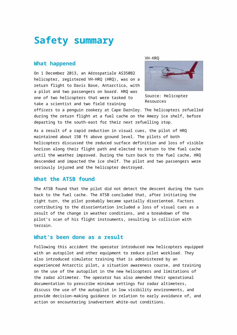
What happenedOn 1 December 2013, an Aérospatiale AS350B2 helicopter, registered VH-HRQ (HRQ), was on a return flight to Davis Base, Antarctica, with a pilot and two passengers on board. HRQ was one of two helicopters that were tasked to take a scientist and two field training officers to a penguin rookery at Cape Darnley. The helicopters refuelled during the return flight at a fuel cache on the Amery ice shelf, before departing to the south-east for their next refuelling stop.
As a result of a rapid reduction in visual cues, the pilot of HRQ maintained about 150 ft above ground level. The pilots of both helicopters discussed the reduced surface definition and loss of visible horizon along their flight path and elected to return to the fuel cache until the weather improved. During the turn back to the fuel cache, HRQ descended and impacted the ice shelf. The pilot and two passengers were seriously injured and the helicopter destroyed.
What the ATSB foundThe ATSB found that the pilot did not detect the descent during the turn back to the fuel cache. The ATSB concluded that, after initiating the right turn, the pilot probably became spatially disoriented. Factors contributing to the disorientation included a loss of visual cues as a result of the change in weather conditions, and a breakdown of the pilot’s scan of his flight instruments, resulting in collision with terrain.
What's been done as a resultFollowing this accident the operator introduced new helicopters equipped with an autopilot and other equipment to reduce pilot workload. They also introduced simulator training that is administered by an experienced Antarctic pilot, a situation awareness course, and training on the use of the autopilot in the new helicopters and limitations of the radar altimeter. The operator has also amended their operational documentation to prescribe minimum settings for radar altimeters, discuss the use of the autopilot in low visibility environments, and provide decision-making guidance in relation to early avoidance of, and action on encountering inadvertent white-out conditions.
Safety messageThis accident provides a timely reminder to flight crews of the importance of monitoring the flight instruments when encountering areas of reduced visual cues. The risks associated with flight in these conditions have been highlighted on the ATSB website as a SafetyWatch priority, along with a number of strategies to help manage the risk and links to relevant safety resources.
Source: Helicopter Resources
VH-HRQ
Contents
The occurrence.................................................................................................................1Flight to Cape Darnley 1Return flight to Davis 2
Context.............................................................................................................................. 6Pilot information 6
Qualifications and experience 6Recent history 6
Aircraft information 6General information 6Maintenance History 6Avionics 7Examination of the wreckage 7
Meteorological information 7Organisational and management 8
Contractual arrangements 8Pilot’s Operations Safety Manual 8Safety management 8
Additional information 9Spatial disorientation 9Previous accidents in low visibility conditions 10
Safety analysis................................................................................................................12Introduction 12Forecast weather 12Spatial disorientation 12Hazard identification 13
Findings........................................................................................................................... 14Contributing factors 14Other findings 14
Safety issues and actions..............................................................................................15Proactive safety action 15
General details................................................................................................................16Occurrence details 16Aircraft details 16
Sources and submissions..............................................................................................17Sources of information 17References 17Submissions 17
Australian Transport Safety Bureau..............................................................................18Purpose of safety investigations 18Developing safety action 18

› 1 ‹
ATSB – AO-2013-216
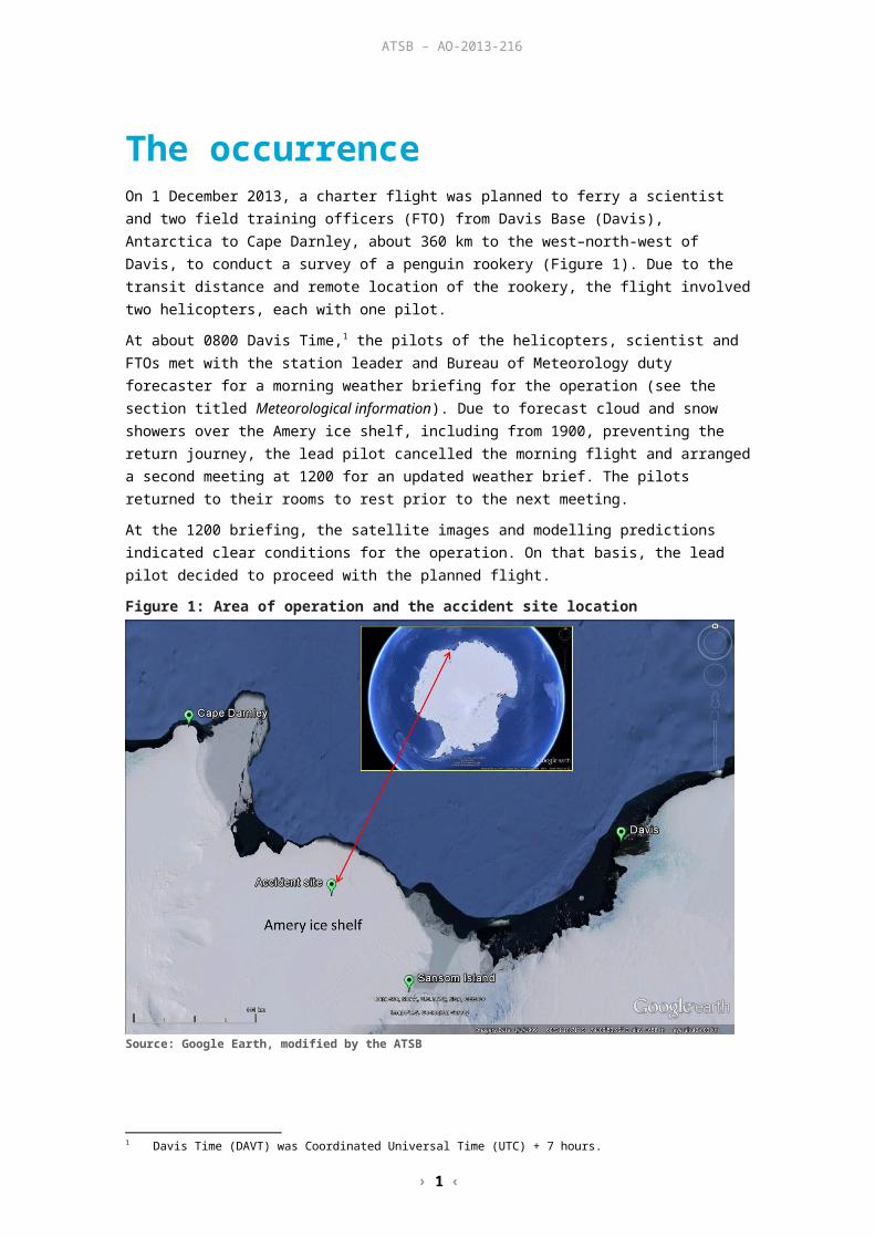
The occurrenceOn 1 December 2013, a charter flight was planned to ferry a scientist and two field training officers (FTO) from Davis Base (Davis), Antarctica to Cape Darnley, about 360 km to the west–north-west of Davis, to conduct a survey of a penguin rookery (Figure 1). Due to the transit distance and remote location of the rookery, the flight involved two helicopters, each with one pilot.
At about 0800 Davis Time,1 the pilots of the helicopters, scientist and FTOs met with the station leader and Bureau of Meteorology duty forecaster for a morning weather briefing for the operation (see the section titled Meteorological information). Due to forecast cloud and snow showers over the Amery ice shelf, including from 1900, preventing the return journey, the lead pilot cancelled the morning flight and arranged a second meeting at 1200 for an updated weather brief. The pilots returned to their rooms to rest prior to the next meeting.
At the 1200 briefing, the satellite images and modelling predictions indicated clear conditions for the operation. On that basis, the lead pilot decided to proceed with the planned flight.
Figure 1: Area of operation and the accident site location
Source: Google Earth, modified by the ATSB
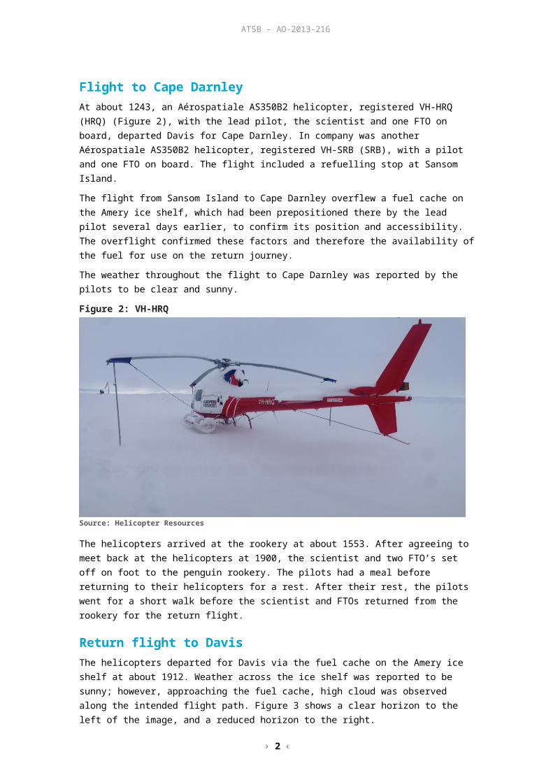
Flight to Cape DarnleyAt about 1243, an Aérospatiale AS350B2 helicopter, registered VH-HRQ (HRQ) (Figure 2), with the lead pilot, the scientist and one FTO on board, departed Davis for Cape Darnley. In company was another Aérospatiale AS350B2 helicopter, registered VH-SRB (SRB), with a pilot and one FTO on board. The flight included a refuelling stop at Sansom Island.
The flight from Sansom Island to Cape Darnley overflew a fuel cache on the Amery ice shelf, which had been prepositioned there by the lead pilot several days earlier, to confirm its position and accessibility. The overflight confirmed these factors and therefore the availability of the fuel for use on the return journey.
1 Davis Time (DAVT) was Coordinated Universal Time (UTC) + 7 hours.

› 2 ‹
ATSB – AO-2013-216
The weather throughout the flight to Cape Darnley was reported by the pilots to be clear and sunny.
Figure 2: VH-HRQ
Source: Helicopter Resources
The helicopters arrived at the rookery at about 1553. After agreeing to meet back at the helicopters at 1900, the scientist and two FTO’s set off on foot to the penguin rookery. The pilots had a meal before returning to their helicopters for a rest. After their rest, the pilots went for a short walk before the scientist and FTOs returned from the rookery for the return flight.
Return flight to DavisThe helicopters departed for Davis via the fuel cache on the Amery ice shelf at about 1912. Weather across the ice shelf was reported to be sunny; however, approaching the fuel cache, high cloud was observed along the intended flight path. Figure 3 shows a clear horizon to the left of the image, and a reduced horizon to the right.
Figure 3: En route to the fuel cache
Source: One of the occupants of the helicopters
› 3 ‹
ATSB – AO-2013-216
On descent to the fuel cache, the pilot of HRQ set the decision height selector on the helicopter’s radar altimeter (RADALT)2 to activate the associated warning light and aural alarm at 120 ft above ground level (AGL) during the approach. The helicopters arrived at the fuel cache at about 2014 (Figure 4).
Figure 4: VH-SRB landing at the fuel cache
Source: One of the occupants of the helicopters
While refuelling, the occupants of the helicopters noted that the cloud height had reduced, although a definite horizon remained visible. After a discussion about the weather, the pilots decided to continue the flight and loaded the empty fuel drums into SRB.
The helicopters departed the fuel cache at 2036 for their next refuelling stop at Sansom Island with the pilot of HRQ in the lead.
Both pilots recalled that, about 7 km south-east of the fuel cache, and as the pilot of HRQ approached about 150 ft AGL, there was a rapid reduction in surface definition and visible horizon along the planned flight path. The occupants of both helicopters commented on how rapidly the visibility changed from being clear to no visible horizon, and on the reduction to no surface definition along the flight path. Recorded altitude data3 for HRQ and SRB indicated that the pilot of HRQ maintained about 150 ft AGL and, due to the reducing visibility, the pilot of SRB, who was at about 250 ft AGL and 1 km behind HRQ, radioed the pilot of HRQ and requested him to slow down. The pilot of HRQ complied and, after a brief discussion over the radio, the pilots elected to return to the fuel cache until the weather improved.
The pilots reported that there was a visible horizon and sunshine on the ice shelf to the right of their intended flight path and elected to turn in that direction. While turning to the right at about 15° angle of bank and with degraded visual cues, the pilot of HRQ did not notice that the helicopter had commenced a descent until hearing the RADALT aural alarm. The pilot reported scanning the RADALT in response and noting the height reducing through about 100 ft before impacting the ground very shortly after.
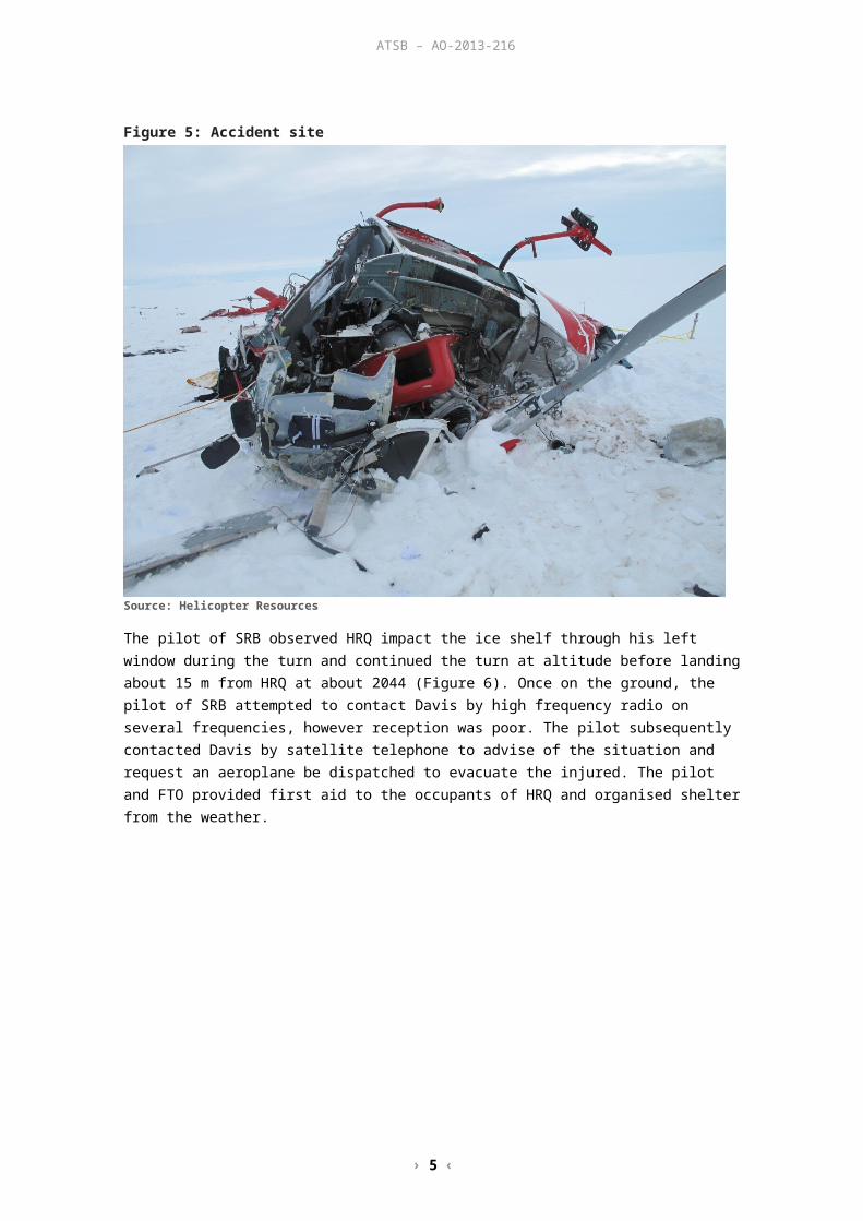
The impact was in a southerly direction, about 9 km south-east of the fuel cache. The pilot, scientist and FTO in HRQ were seriously injured and the helicopter destroyed (Figure 5).
2 Also known as radio altimeter, a RADALT is an on board system that provides an accurate indication of height above ground level.
3 Latitude, longitude, altitude and time data was recorded every few minutes as part of a satellite tracking system.
› 4 ‹
ATSB – AO-2013-216
Figure 5: Accident site
Source: Helicopter Resources
The pilot of SRB observed HRQ impact the ice shelf through his left window during the turn and continued the turn at altitude before landing about 15 m from HRQ at about 2044 (Figure 6). Once on the ground, the pilot of SRB attempted to contact Davis by high frequency radio on several frequencies, however reception was poor. The pilot subsequently contacted Davis by satellite telephone to advise of the situation and request an aeroplane be dispatched to evacuate the injured. The pilot and FTO provided first aid to the occupants of HRQ and organised shelter from the weather.

› 5 ‹
ATSB – AO-2013-216
Figure 6: Aerial view of the accident site
Source: Helicopter Resources, modified by the ATSB
Due to the deteriorating weather and the surrounding crevasse region, aeroplane support from Davis was unable to land at the accident site. The aeroplane remained in the area for about 30 minutes, and a doctor on board was able to communicate with the pilot and FTO, and provide clinical advice. The occupants of both helicopters remained on-site overnight.
The following day, the pilot of SRB flew two of the injured from HRQ to Sansom Island, where they were transferred to an aeroplane for the flight to Davis. A doctor who flew to Sansom Island in the aeroplane accompanied the pilot of SRB back to the accident site to evacuate the remaining patient.
As a result of their injuries, the occupants of HRQ were transferred to Hobart, Tasmania for hospitalisation.
› 6 ‹
ATSB – AO-2013-216
ContextPilot informationQualifications and experienceThe pilot held a Commercial Pilot (Helicopter) Licence and night visual flight rules (VFR)4 rating and was endorsed on the Aérospatiale AS350. The pilot also held a valid Class 1 Aviation Medical Certificate.
The pilot indicated that, prior to the accident flight, he had accrued a total of 4,680 hours helicopter flight time, of which 827 hours were in AS350 helicopters and just over 8 hours was on instruments. The pilot’s most recent check flights were carried out in preparation for the deployment to Antarctica. The first was on 6 September 2013 and involved seven night circuits in a no moon, dark night environment. The second was on 11 October 2013 and involved about 1 hour of instrument flight time and 12 night circuits. On each check flight, the pilot was confirmed to be at a satisfactory standard.
The pilot was on his second deployment to the Antarctic with the operator. Their first deployment was as a line pilot and this second deployment was as the senior pilot. Earlier in their career, the pilot flew in Canada in a snow and ice environment.
Recent historyIn the week prior to the accident, the pilot flew about 8 hours in HRQ. This included a 4 hour flight on 26 November 2013 to position fuel drums on the Amery ice shelf. On 1 December 2013, the pilot conducted three flights totalling 3.8 hours prior to the accident.
The pilot reported that on the evening of 30 November 2013 they retired to their accommodation at about 2030, were asleep by about 2130 and awoke at 0600 the following morning. That afforded the pilot about an 8.5-hour sleep opportunity. The pilot reported that this was a standard sleep routine and that he was well rested with no health issues prior to the flight.
The pilot was on a 3-month deployment to the Antarctic, and was scheduled to return home about 2 weeks after the accident. The pilot had accumulated about 24 hours flying during the deployment.
Aircraft informationGeneral informationHRQ was an Aérospatiale AS350B2 and was manufactured in France in 1981 (serial number 1429). It was first registered in Australia on 4 June 2001 and had accumulated about 6,159 hours total time in service at the time of the accident. The helicopter had been appropriately modified to incorporate a single Honeywell LTS101-700D-2 turboshaft engine under a supplemental type certificate.
In the charter role, HRQ had seating for a pilot and five passengers. It was certified for day and night charter operations under the day/night VFR.
Maintenance HistoryExamination of the helicopter’s maintenance records indicated that it was maintained to a night VFR standard in accordance with the operator’s system of maintenance. It had a current Certificate of Registration, Certificate of Airworthiness and maintenance release. At the time of the accident, all of the required maintenance had been completed on the helicopter.
4 Visual flight rules (VFR) are a set of regulations that allow a pilot to only operate an aircraft in weather conditions generally clear enough to allow the pilot to see where the aircraft is going.
› 7 ‹
ATSB – AO-2013-216
AvionicsThe helicopter had the required instruments and systems to meet the night VFR standard. This did not include the installation of an autopilot or automatic stabilisation system, nor were such systems required by Civil Aviation Order (CAO) 20.18 for flight under the night VFR. Similarly, a ground proximity warning system was not fitted to the helicopter.
The helicopter’s RADALT indicated its height above ground level (AGL) up to a maximum indicated altitude of 2,500 ft. RADALT accuracy is affected by the parent aircraft’s pitch (nose-up or –down) and bank angles. In general, if an aircraft’s angle of bank exceeds about 30° and/or the pitch angle exceeds about 20°, the indicator would display a ‘slant’ or angular height above the ground that was greater than the actual height AGL. In the case of the reported 15° angle of bank right turn by the pilot of HRQ, the activation of the RADALT aural alert would have reflected an accurate height AGL.
Examination of the wreckageDue to the remote location and operational nature of the accident, and the availability and consistency of the relevant information from other sources, the helicopter wreckage was not examined by the ATSB.
Meteorological informationThe pilots were given about 4 weeks’ notice of a request to take the scientist to survey a penguin rookery at Cape Darnley and the job was discussed by the crew during their travel by ship to Antarctica. In the weeks leading up to the planned survey, the crew monitored the weather for a period of suitable weather. With a suitable period identified, a departure date was set.
During the 0800 weather briefing for the flight, the pilots, scientist, field training officers and station leader were briefed on the expected weather by the Bureau of Meteorology (BoM) duty forecaster. This included a review of meteorological observations, forecasts and analyses as well as satellite images of cloud formations and weather predictions that were based on several meteorological models. The weather was clear at Davis; however, high relative humidity was indicated for the second half of the flight over the Amery ice shelf and the forecast predicted cloud with isolated snow showers. This included a bank of cloud over the ice shelf from 1900.
At the 1200 briefing, satellite imagery and BoM modelling indicated that the intended flight path would be clear of cloud, and was tending to stay clear. The forecast indicated that significant low cloud was expected to move down from the north and east, over the eastern ice shelf and at Davis after about 2200. This was after the pilots’ intended arrival time back at Davis.
The crew reported that throughout the flight to the penguin rookery, the weather appeared similar to that forecast for the day.
As the BoM duty forecaster became aware of weather changes, these were passed to the Davis communications officer, who in-turn would pass the details to the pilots. At about 1730, based on the latest satellite imagery, the BoM duty forecaster advised the Davis communications officer that low cloud had moved over the intended flight path in the northern part of the Amery ice shelf. Subsequently, at about 1805 the local area forecast for Davis indicated increased cloud and reductions in surface and horizon definition from 1800 to 2200. The pilot of HRQ reported that this information was passed to them via satellite phone during the flight to the fuel cache on the Amery ice shelf.
At about the time of the accident, the sun was to the north and about 19° above the horizon.5
5 Astronomical information was obtained from Geoscience Australia at www.ga.gov.au/geodesy/astro.

› 8 ‹
ATSB – AO-2013-216
Organisational and management Contractual arrangementsThe helicopter operator owned a number of helicopters that were routinely contracted throughout Australia, Antarctica and various overseas locations. In Antarctica, the helicopter operator was contracted to provide helicopter support to the Australian Antarctic Division,6 based at Davis. Specifically the operator provided the helicopters, pilots and maintenance personnel in support of division tasks, surveys and so on.
Pilot’s Operations Safety ManualPilot checking and trainingThe required flight crew ground and flying training prior to departure for Antarctica was listed in the operator’s Pilot’s Operations Safety Manual ANTARCTIC AND SUB-ANTARCTIC OPERATIONS. Amongst other training, this included night VFR training sufficient to obtain that rating. Pilots were also trained in basic instrument flight training during their night training as required by the chief pilot. This involved practicing departures, approaches and landings to minimal ground lighting in a dark night environment.
One of the operator’s check and training pilots and Antarctic aviation experts advised that the night training was designed to simulate the low definition that would be experienced in the Antarctic.
Briefing Notes – Operations in AntarcticaThe Pilot’s Operations Safety Manual also provided briefing notes on operations in Antarctica that were to be covered in all prospective Antarctic pilots’ training. The Field Operations section of the notes was relevant to the return flight to Cape Darnley and included specific guidance on the hazards associated with white-out (see the section titled Additional information) and operations in drift and blowing snow and crevassed areas.
Repeat entries in the briefing notes stipulated that Antarctic operations were always carried out under the VFR. Consistent with this requirement, the operator required its pilots to never lose visual contact with the surface when below 2,000 ft.
Separately, the Pilot’s Operations Safety Manual defined safety and survival equipment that was to be carried on all flights. HRQ and SRB were each carrying that equipment, which was used in support of the period spent at the accident site before evacuation.
Single helicopter operations in the Antarctic
Information on shore-based operations in the Antarctic was detailed in the operators Pilot’s Operations Safety Manual, ANTARCTIC AND SUB-ANTARCTIC OPERATIONS. The manual stated that flight operations were to normally to be undertaken by two helicopters in company for search and rescue (SAR) purposes. Operations by a single helicopter were not to occur unless, among other requirements, another serviceable helicopter and crew was available for an immediate SAR response. In such cases, each helicopter was to be within 1 hour’s flying time of each other.
Safety managementAt the time of the accident the regulatory requirement for operators to have a safety management system (SMS) did not apply to the type of operations undertaken by the operator. However they had developed an SMS on their own initiative, which was broadly based on the framework described in the International Civil Aviation Organization (ICAO) Safety Management Manual.7 This included the need for, and maintenance of a formal hazard identification process and
6 An agency of the Department of Sustainability, Environment, Water, Population and Communities.7 ICAO Doc 9859 AN/474 Third Edition 2013.

› 9 ‹
ATSB – AO-2013-216
associated risk assessment. The format and content of the operator’s SMS, including for hazard identification and risk assessment, was described in the company’s Safety Manual.
In respect of its operations in Antarctic conditions, the operator had identified a medium level risk associated with ‘…collision with [the] ice surface due lack of surface reference, poor visibility or lack of horizon reference, dome effect’. Risk controls were listed in response to white-out, including that pilots landing in such conditions shall use a visual ground reference (such as fuel drums) but not use their RADALT as a sole means of determining height.
More specifically, the SMS highlighted a number of commercial operations that the operator felt were more inherently dangerous than normal and would therefore not be undertaken. In addition, flight in icing conditions, which were defined by the operator as ‘In visible moisture below + 4 °C (rain or cloud)…’, were prohibited. The operator cautioned that these conditions were often encountered near the coast in Antarctica.
The operator also listed a number of operations that were considered their most hazardous. These included approaches to land in Antarctica in white-out conditions or when there was poor surface definition. Risk treatments were promulgated for operations in these conditions and the importance of visual reference with the surface to determine height was reiterated. The avoidance of unnecessary risk was also discussed, as well as the maintenance of safety margins associated with various hazards such as weather and the application of escape routes.
Additional informationSpatial disorientationOverviewSpatial disorientation (SD) occurs when a pilot does not correctly sense the position, motion and attitude of an aircraft relative to the surface of the Earth. It is often simply described as the inability to determine ‘which way is up’, although the effects of disorientation can be considerably more subtle than that description.
Spatial disorientation is likely to happen in conditions in which visual cues are poor or absent, such as in adverse weather, at night, or in flat-light or white-out conditions.8 In the case of the pilot of HRQ, the pilot’s normal scan of their instruments and therefore sense of their position relative to the ground, or height, was compromised by their focus during the turn on visual features to the right of the helicopter.
Flat-light conditionsFlat-light, which is also known as sector or partial white-out, describes an optical illusion that can occur in good visibility with no snow falling and the accompanying ground surface covered in unbroken snow. An overcast sky diffuses the available light, and the horizon is indistinguishable due to the cloud and snow-covered surface blending in the diffused light. In these conditions, the pilot’s depth-of-field is greatly affected due to the lack of surface definition.
The lack of a horizon and surface contrast in flat-light conditions makes the aircrafts attitude, altitude and distance and closure rates to objects very difficult to assess during visual flight. Indeed, the associated optical illusion can give the pilot a sense of climbing or descending, when they are actually in level flight. 9
Flat-light conditions can also occur in dust, sand, mudflats and glassy water environments.
8 More information about spatial disorientation can be found in the ATSB aviation research and analysis report B2007/0063, and ATSB investigation AO-2011-102, available from the ATSB website at www.atsb.gov.au.
9 www.faasafety.gov/gslac/ALC/libview_normal.aspx?id=6844.
› 10 ‹
ATSB – AO-2013-216
White-out conditionsWhite-out occurs when the environment is engulfed in blowing snow, creating a uniform white glow. In this environment, the definition between the sky and ground cannot be discerned. The uniform white light conditions result in no contrast or shadows and make it impossible to determine orientation and depth-of-field. This milk-bowl effect has also been experienced by operators in desert environments due to the featureless terrain and in sand storms. White-out conditions can also be considered similar to flight in dark night conditions due to the lack of visual cues available to the pilot for maintaining visual flight. However, unlike nightfall, the onset of white-out conditions can be quite rapid. Reports from passengers described the rapid on-set of weather in the area as being consistent with the ‘milk-bowl’ effect, which resulted in degraded visual cues.
With the onset of white-out conditions, a transition from visual flight to instrument flight is required. The use of the aircraft’s flight instruments is essential to maintain the aircraft attitude and avoid SD.
Previous accidents in low visibility conditionsHU369HS accident, 1 January 198210
On 1 January 1982, a Hughes 369HS helicopter, registered VH-PMY, in formation with another company helicopter, departed Casey station, Antarctica, to collect a glaciology party from the Vanderford glacier. Three unsuccessful attempts were made throughout the day, including as a result of the need to return to base due to degraded visual cues. On the fourth attempt, the party set off a flare, which was observed by the helicopter crew.
On the approach to the campsite in poor visibility, the pilot misidentified the orange flare for a tent. After correctly identifying the flare, the pilot noted the helicopter’s airspeed increasing and initiated a climb. The helicopter’s left skid impacted terrain and was torn from the helicopter, requiring the pilot to discontinue the landing and return to Casey station.
The engineering team at Casey were able to prop the helicopter upright for a successful landing with no injuries. VH-PMY was operated by the same operator as VH-HRQ.
Three AS350B2 accidents, 10 September 199911
On 10 September 1999, there were three helicopter accidents in the same area of the United States in relatively quick succession. Each was investigated by the United States National Transportation Safety Board (NTSB).
In the first accident, a Eurocopter AS350B2 helicopter, registered N6007S, was returning to Juneau, Alaska, following a sightseeing flight. While in a gradual descent over a large, featureless and snow-covered ice field, a localized snow shower momentarily reduced the pilot’s forward visibility. The helicopter struck the ice field, slid about 150 ft and nosed over. Varying degrees of injury were sustained by the passengers and crew. The NTSB found that the pilot continued flight into instrument meteorological conditions in flat-light and white-out conditions and snow, over snow-covered terrain.
The second accident occurred when another AS350B2, registered N6052C, was dispatched to search for the now overdue N6007S. N6052C also struck a snow-covered ice field, sliding about 75 ft and rolling over to the right. The pilot believed that seconds prior to the impact he was at least 500 ft above the surface.
A third AS350B2, registered N6099Y, which was initially dispatched to assist N6007S, responded to the second accident involving N6052C. However, due to poor weather, the pilot of N6099Y returned to the airport for fuel and wait for the weather to improve. Upon returning to N6052C and recovering the crew, the search resumed for N6007S. N6007S was located and, while on a slow approach to the accident site, the helicopter impacted terrain; sliding about 50 ft, nosing over and
10 ATSB investigation number 198202437.11 Available on the United States National Transportation Safety Board website at www.ntsb.gov.

› 11 ‹
ATSB – AO-2013-216
rolling over. Minor injuries were sustained by all on board. The pilot stated that just before impact, he too was sure that his aircraft was at least 500 ft above ground level.
The NTSB found that in the second and third accidents at Juneau, ground clearance was not maintained in flat-light conditions over snow-covered terrain. The NTSB also found that self-induced pressure to continue the search contributed to the accidents.
AS350BA accident, 17 August 200512
On 17 August 2005, a Eurocopter AS350BA helicopter, registered ZK-HGI, departed a helipad near the Franz Josef Glacier township, New Zealand, with a pilot and seven passengers on board. The flight was for sightseeing and a snow experience at a snow field above Franz Josef Glacier. Marker poles with flags were located at the landing site to assist with ground reference for landing; however, these had been covered by a recent snowfall. On approach, the helicopter’s skid-landing gear contacted the surface while drifting to the right and the helicopter rolled onto its right side. The pilot and passengers were not injured.
The New Zealand Transport Accident Investigation Commission found that the pilot encountered white-out conditions moments before landing. This resulted in loss of surface definition, and the inability of the pilot to detect the right drift when the skids contacted the surface.
AS350B2 accident, 1 June 201213
On 1 June 2012 a Eurocopter AS350B2 helicopter, registered C-FBHN, departed Terrace Airport in British Columbia, Canada for a local mountain training flight, with two pilots and one aircraft maintenance engineer on board. The helicopter struck the snow-covered side of a mountain ravine in daylight conditions. The aircraft was destroyed, and there were no survivors. The Transportation Safety Board of Canada found that few visual references would have been available to the pilot to aid depth perception. Flat-light most likely occurred due to an overcast sky resulting in flat-light with little or no horizon.
12 Available on the New Zealand Transport Accident Investigation Commission website at www.taic.org.nz. 13 Available on the Transportation Safety Board of Canada website at www.bst-tsb.gc.ca.

› 12 ‹
ATSB – AO-2013-216
Safety analysisIntroductionThe right turn by the pilot of HRQ about 7 km south-east of the Amery ice shelf fuel cache was consistent with avoiding the hazards associated with the option of a landing straight ahead in conditions of rapidly decreasing surface definition and diminished visual horizon, and the pilot’s desire to remain visual. This desire reflected the pilot’s qualifications and the helicopter’s certification and equipment standard for flight under the visual flight rules. It was also in accord with the operator’s requirement for its Antarctic operations to be carried out under those rules, and with visual contact with the surface when below 2,000 ft.
Forecast weatherThe weather for the return flight was forecast to be clear, which was consistent with the observed weather to the north throughout the day. A cloud bank did move to the south earlier than predicted and across the flight path to Sansom Island, but this was discussed by the pilots at the Amery ice shelf fuel cache and a conscious decision made to continue the flight.
Shortly after the departure from the fuel cache and in good visual conditions, there was a reported rapid reduction in visual cues that compelled the pilot of HRQ to level off at 150 ft RADALT. This was probably explained by the combined effect of the movement of the cloud bank to the south and the sun’s location to the north, creating flat-light conditions towards the south-east. Concurrently, the visibility and surface definition to the north-west of the cloud bank was considered by the pilots to be good, most likely due to the sunlight not being diffused in that area by the cloud bank.
The flat-light conditions resulted in poor surface definition and the lack of a horizon to the front of HRQ and affected the pilot’s depth-of-field, precipitating the pilot’s decision to turn right in an effort to maintain visual flight. During the turn, the associated difficulty in assessing the helicopter’s attitude and altitude, and the distance and closure rates to objects increased the importance of the pilot scanning their aircraft instruments. As the commencement of the turn was at about 150 ft above ground level, the recovery time available was minimised, should an unintended descent commence.
Spatial disorientationOne of the most likely times for disorientation is when flying in reduced visibility. Disorientation often occurs in areas of reduced visual cues due to a pilot’s natural tendency to attempt to continue previously visual flight, as vision provides for up to 80 per cent of human orientation (AVMED 2012).
Due to the lack of external visual cues to the south-east, and with a good horizon to the right and behind the helicopter, the pilot’s attention was diverted away from the flight instruments, and drawn to the increased visual environment during the right turn. This focus distracted them from their normal scan of the flight instruments, which provides confirmation of the helicopter’s speed and height.
Maintaining a set altitude during the turn would have been difficult due to a lack of localised (or proximal) cues to provide a depth-of-field. Given the lack of such cues, the breakdown in the pilot’s normal scan of the instruments increased the risk that a deviation from the planned altitude would go unnoticed.
The helicopter was fitted with a radar altimeter (RADALT), which was capable of providing an aural warning and caution light, indicating that the aircraft had passed through a pre-selected altitude above terrain. The pilot had pre-set the altitude decision height selector to 120 ft during

› 13 ‹
ATSB – AO-2013-216
the approach to the fuel cache, and the setting remained unaltered for the departure. While the pilot recalled hearing the aural warning prior to the impact, it was not in sufficient time to perform a recovery manoeuvre.
Hazard identificationThe operator had recognised the hazards associated with flight in Antarctic conditions and had implemented turn-backs/night training to addresses the associated risk. This training was conducted using flight instruments to maintain height in the turn.
On the accident flight, a timely decision by the pilot to reference both the flight instruments and the clear horizon to the right, rather than flying by visual reference only, would most likely have provided the additional safety margin necessary to maintain terrain clearance during the return to the landing site.
SurvivalDue to the flight time and remote nature of the journey to the penguin rookery, the flight involved two helicopters. This provided for an immediate search and rescue response as detailed in the operators Pilot’s Operations Safety Manual.
The three occupants of HRQ were severely injured during the impact sequence, with one person trapped in the wreckage. The occupants of SRB were able to render first aid to the injured within minutes of the accident and organise shelter. In addition, the occupants of SRB maintained a communication link with Davis Base and the doctor on board the support aeroplane, ensuring an appropriate medical response. Subsequently the crew of SRB assisted with the recovery of the survivors to Davis.
The availability of, and assistance provided by the crew of SRB to the injured increased their chances of survival.

› 14 ‹
ATSB – AO-2013-216
FindingsFrom the evidence available, the following findings are made with respect to the collision with terrain that occurred about 240 km west of Davis Base, Antarctica, on 1 December 2013 involving an Aérospatiale AS350B2 helicopter, registered VH-HRQ. These findings should not be read as apportioning blame or liability to any particular organisation or individual.
Contributing factors Soon after departure, and while cruising at 150 ft above ground level, the pilot encountered a
rapid reduction in visual cues along the intended flight path, which led to spatial disorientation and subsequent collision with terrain.
The difficulty in the flat-light conditions of assessing the helicopter’s attitude and altitude and distance and closure rates to objects increased the importance of the pilot scanning their aircraft instruments during the attempted right turn.
The pilot’s focus on attaining the still-visual environment to the right of track distracted them from their normal instrument scan and, in the absence of localised (or proximal) cues to provide depth-of-field, increased the risk that any altitude deviation would go unnoticed.
During the right turn from an entry height of 150 ft above ground level, the helicopter started descending and the pilot did not monitor the flight instruments in time to detect and correct the descent.
Other findings The attempted right turn was consistent with avoiding a landing straight ahead in conditions of
rapidly decreasing surface definition and diminished visual horizon, and the pilot’s desire to remain visual.
The pilot’s desire to remain visual reflected their qualifications and the helicopter’s certification and equipment standard, and was in accordance with the operator’s requirement for its Antarctic operations when below 2,000 ft.
The presence of the second helicopter provided for a rapid medical response and assisted with the recovery of the survivors, increasing their chances of survival.

› 15 ‹
ATSB – AO-2013-216
Safety issues and actionsThe ATSB did not identify any organisational or systemic issues that might adversely affect the future safety of aviation operations. However, whether or not the ATSB identifies any safety issues in the course of an investigation, relevant organisations may proactively initiate safety action in order to reduce their safety risk. The ATSB has been advised of the following proactive safety action in response to this occurrence.
Proactive safety action The operator has advised of the following safety action in response to this occurrence:
New helicopters with additional equipment, including an autopilot, and the associated training have been introduced. This helicopter/equipment combination is intended to reduce pilot workload and create a safer work environment.
Simulator training will be carried out under the supervision of an experienced Antarctic pilot. Night flying training has been amended to include the use of the autopilot and the limitations of
the radar altimeter. The Pilot’s Operations Safety Manual has been amended to include:
- prescribed minimum settings for radar altimeters- the use of the autopilot for maintaining height in turns and exiting low visibility situations- decision-making guidance in relation to the early avoidance of, and action if inadvertent
white-out is encountered. A situation awareness course has been developed for the operator’s pilots.
Additional safety actionAlthough not in response to this accident, on 17 March 2015 an amendment to Civil Aviation Order 20.18 was registered. This amendment will require a helicopter operating under the visual flight rules at night to have an autopilot or stability augmentation system, or to include a two-pilot crew where orientation cannot be maintained ‘by the use of visual external surface cues as a result of lights on the ground or celestial illumination’.
The change to the required aircraft equipment, effective 1 January 2016, recognises that control of a helicopter that is operating under the visual flight rules at night is significantly more difficult when there are limited external visual cues.

› 16 ‹
ATSB – AO-2013-216
General detailsOccurrence details
Date and time: 1 December 2013 – 2043 DAVT
Occurrence category: Accident
Primary occurrence type: Collision with terrain
Location: 240 km west of Davis Base, Antarctica
Latitude: 69° 01.40’ S Longitude: 72° 11.80’ E
Aircraft detailsManufacturer and model: Aérospatiale AS350B2
Year of manufacture: 1981
Registration: VH-HRQ
Operator: Helicopter Resources
Serial number: 1429
Total Time In Service 6,159 hours
Type of operation: Charter
Persons on board: Crew – 1 Passengers – 2
Injuries: Crew – 1 (Serious) Passengers – 2 (Serious)
Damage: Destroyed
› 17 ‹
ATSB – AO-2013-216
Sources and submissionsSources of informationThe sources of information during the investigation included the:
pilot and passengers of VH-HRQ operator of VH-HRQ pilot of VH-SRB Australian Antarctic Division Bureau of Meteorology.
ReferencesAviation Medicine for ADF Aircrew, 3rd Edition 2012, Revised and Edited by Dr Gordon G. Cable, RAAF Institute of Aviation Medicine (AVMED).
SubmissionsUnder Part 4, Division 2 (Investigation Reports), Section 26 of the Transport Safety Investigation Act 2003 (the Act), the ATSB may provide a draft report, on a confidential basis, to any person whom the ATSB considers appropriate. Section 26 (1) (a) of the Act allows a person receiving a draft report to make submissions to the ATSB about the draft report.
A draft of this report was provided to the pilots of VH-HRQ and VH-SRB, the operator of VH-HRQ, the Bureau of Meteorology, the Civil Aviation Safety Authority (CASA) and the Bureau d'Enquêtes et d'Analyses pour la Sécurité de l'Aviation Civile (French BEA).
Submissions were received from the helicopter operator, the pilot of VH-SRB, the Bureau of Meteorology and CASA. The submissions were reviewed and where considered appropriate, the text of the report was amended accordingly.

› 18 ‹
ATSB – AO-2013-216
Australian Transport Safety BureauThe Australian Transport Safety Bureau (ATSB) is an independent Commonwealth Government statutory agency. The ATSB is governed by a Commission and is entirely separate from transport regulators, policy makers and service providers. The ATSB’s function is to improve safety and public confidence in the aviation, marine and rail modes of transport through excellence in: independent investigation of transport accidents and other safety occurrences; safety data recording, analysis and research; fostering safety awareness, knowledge and action.
The ATSB is responsible for investigating accidents and other transport safety matters involving civil aviation, marine and rail operations in Australia that fall within Commonwealth jurisdiction, as well as participating in overseas investigations involving Australian registered aircraft and ships. A primary concern is the safety of commercial transport, with particular regard to fare-paying passenger operations.
The ATSB performs its functions in accordance with the provisions of the Transport Safety Investigation Act 2003 and Regulations and, where applicable, relevant international agreements.
Purpose of safety investigationsThe object of a safety investigation is to identify and reduce safety-related risk. ATSB investigations determine and communicate the factors related to the transport safety matter being investigated.
It is not a function of the ATSB to apportion blame or determine liability. At the same time, an investigation report must include factual material of sufficient weight to support the analysis and findings. At all times the ATSB endeavours to balance the use of material that could imply adverse comment with the need to properly explain what happened, and why, in a fair and unbiased manner.
Developing safety actionCentral to the ATSB’s investigation of transport safety matters is the early identification of safety issues in the transport environment. The ATSB prefers to encourage the relevant organisation(s) to initiate proactive safety action that addresses safety issues. Nevertheless, the ATSB may use its power to make a formal safety recommendation either during or at the end of an investigation, depending on the level of risk associated with a safety issue and the extent of corrective action undertaken by the relevant organisation.
When safety recommendations are issued, they focus on clearly describing the safety issue of concern, rather than providing instructions or opinions on a preferred method of corrective action. As with equivalent overseas organisations, the ATSB has no power to enforce the implementation of its recommendations. It is a matter for the body to which an ATSB recommendation is directed to assess the costs and benefits of any particular means of addressing a safety issue.
When the ATSB issues a safety recommendation to a person, organisation or agency, they must provide a written response within 90 days. That response must indicate whether they accept the recommendation, any reasons for not accepting part or all of the recommendation, and details of any proposed safety action to give effect to the recommendation.
The ATSB can also issue safety advisory notices suggesting that an organisation or an industry sector consider a safety issue and take action where it believes it appropriate. There is no requirement for a formal response to an advisory notice, although the ATSB will publish any response it receives.