investigation of abandoned ww ii wrecks in · pdf fileinvestigation of abandoned ww ii wrecks...
TRANSCRIPT

Investigation of Abandoned WW II Wrecks in Palau
Tomo Ishimura1
Abstract Over forty Japanese vessels were sunken in the water of Palau during WWII. Some wrecks sunk
in the shallow water at a depth of 20 meters or less and were salvaged. Other wrecks at 30
meters depth or more still remain and are legally protected by the authority of Palau Government
but are seriously threatened by illegal treasure hunters. Initial efforts to identify human remains of
Japanese soldiers were made in 2005. As part of an archaeology advisory team for the
Japanese Government I carried out underwater surveys of sunken WWII vessels in Palau. In
2010 and 2011, I conducted investigations of the WWII vessels again, together with on-shore
research on sites and features associated with the Japanese occupation period, funded by the
Takanashi Foundation for Arts and Archaeology (Japan).
The research revealed that the most of the vessels sunken in Palau were not genuine
military vessels of Japanese Imperial Navy or Army but converted vessels originally built for
non-combat purposes. These vessels were slow in speed and not well-equipped for combat
activity. Most of them were destroyed by American aerial bombing on March 30th 1944. The
evening before (March 29th) the main force of the Japanese Combined Fleet, including its
flagship Musashi, retreated from Palau. It is clear that the vessels left in Palau were abandoned
as a “third wheel” of the Combined Fleet. These abandoned-converted vessels include cargo
carriers, tankers, whaling boats and fishing boats. This implies that Japanese troops were
experiencing a difficult and desperate campaign at that time.
Introduction
Over forty WWII Japanese vessels have been identified in the waters of the
Republic of Palau (see Figures 1, Figure 2, Table 1). Most of them were
destroyed on March 30th – 31st 1944 by the United States of America’s (USA)
attack - Operation Desecrate One. This battle was a historical turning point for
Japanese occupation in Micronesia because the Combined Fleet of the
Japanese Imperial Navy lost their bases in the region, which further impacted on
defeats in the Battle of the Mariana Islands on June 19th – 20th 1944 and the
1 Nara National Research Institute for Cultural Properties, Japan

Battle of Layte on October 23rd – 25th 1944. Therefore the shipwrecks of Palau
offer important evidence for understanding the historical significance of the battle
in Palau. The main aim of my research is to uncover the real situation of the
battle in Palau and document the extent of this underwater cultural heritage
(UCH) in Palau for their future protection and management.
Figure 1. Map around Palau (created by author).
Figure 2. Map of Palau and distribution of Japanese WW II wrecks, insert is map
of shipwrecks in Palau harbour (created by author).
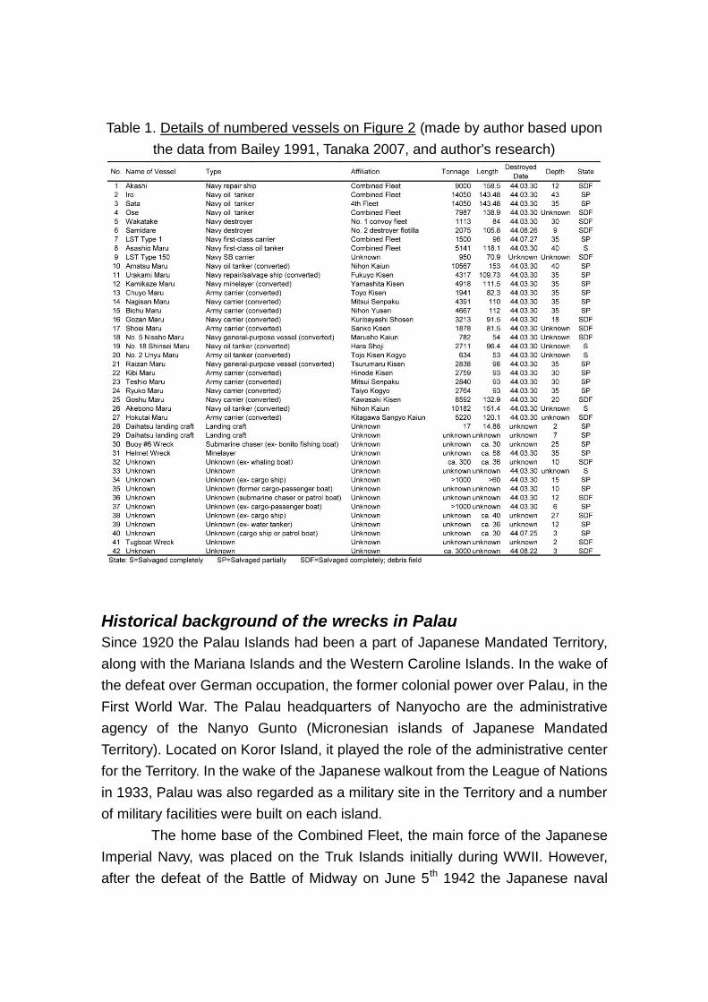
Table 1. Details of numbered vessels on Figure 2 (made by author based upon
the data from Bailey 1991, Tanaka 2007, and author's research)
Historical background of the wrecks in Palau
Since 1920 the Palau Islands had been a part of Japanese Mandated Territory,
along with the Mariana Islands and the Western Caroline Islands. In the wake of
the defeat over German occupation, the former colonial power over Palau, in the
First World War. The Palau headquarters of Nanyocho are the administrative
agency of the Nanyo Gunto (Micronesian islands of Japanese Mandated
Territory). Located on Koror Island, it played the role of the administrative center
for the Territory. In the wake of the Japanese walkout from the League of Nations
in 1933, Palau was also regarded as a military site in the Territory and a number
of military facilities were built on each island.
The home base of the Combined Fleet, the main force of the Japanese
Imperial Navy, was placed on the Truk Islands initially during WWII. However,
after the defeat of the Battle of Midway on June 5th 1942 the Japanese naval
power in the Pacific region declined. The 58th Task Force of the USA conducted
the Operation Hailstone which included air strikes on the Truk Islands on
February 17th – 18th 1944, and the Japanese forces lost two light cruisers (Agano
and Naka) and many other vessels. A week earlier the flagship Musashi, and
other major vessels of the Combined Fleet, had already retreated to Palau on
the 10th of February in anticipation of the attack by the USA forces.
The Combined Fleet regrouped their fleet in Palau. On February 29th a
scout plane of the Japanese Navy sighted a USA task force approaching to the
Caroline Islands. Shigeru Fukudome, the Chief of Staff of the Combine Fleet,
considered that the U.S. forces would initiate a landing operation to Palau so he
decided to withdraw major-force vessels of the Combined Fleet to the
Philippines to set them apart for later use (Yoshimura 1976). In the late afternoon
on February 29th the flagship Musashi, the light cruiser Taiyo, the destroyers
Urakaze and Isokaze, and the other main vessels of the Combined Fleet set off
from Palau Harbor. The rest of the vessels, such as the repair ship Akashi, the oil
tankers Iro and Sata, and a number of cargo ships, were left behind.
A two-day USA air strike named Operation Desecrate One initiated On
February 30th. The remaining vessels were completely destroyed and sunk in
the waters of Palau. Most of the wrecks of Palau are derived as a result of this
one battle.
Investigations of shipwrecks
I carried out underwater archaeological survey at six selected sites in 2010 and
2011 (Ishimura 2010a; Ishimura 2010b). Short summaries of the results are
shown as follows:
Iro
Location: West Urukthapel Anchorage
Depth: The ship is resting upright at 40 meters. The deck is at 28 meters and the
top of the forward tower is at 8 meters.
Orientation (from stern to bow): Southwest
General Information:
Type: Shiretoko Class Combined Fleet Tanker
Length: 143.25 meters

Beam: 17.68 meters
Tonnage: 14,050 tons
Speed: 12 knots
Built: 1922 by Osaka Tekkosho
Destroyed on March 30th, 1944
Brief description:
The Iro was a fleet oiler and supply ship. On March 22nd 1944 on her way from
the Philippines to Palau a torpedo launched from the submarine USS Tunny
hitting her bow forward of the bulkheads. On March 30th 1944 she came under
fire and was bombed during the Operation Desecrate One.
Heavy structural and fire damage to the ship’s engine room, boat deck,
and stack appears to have resulted from the bomb(s). A survivor of the Iro attack
witnessed a direct hit to the stroke engine room where approximately 30
engineers were killed (interviewed by author). An anchor chain extends from the
hawsehole on the starboard side to the floor of the lagoon below. Following the
anchor chain down along the side of the ship one can see the damage caused to
the bow by torpedo. On top of the bow is a large gun mounted on a circular
platform. The gun barrel diameter is 7 inches (17.8 centimeters) and the length is
4.26 meters. A gun identical to the one on the bow is mounted on a platform on
the stern with its barrel pointing about 20 degrees towards the starboard. The
survivor of Iro related that only one of the guns was able to fire against the aerial
attack, due to lack of ammunition (interviewed by author).
In reaction to the information provided by the survivor in 2005 the team
of the Japan Ministry of Health, Labour and Welfare carried out an investigation
in search of the human remains of Japanese soldiers at the Iro, especially in and
around the engine room, however, they were not able to find any (Ishimura
2005).
Akashi
Location: North Urukthapel Anchorage
Depth: Only debris are scattered at a depth of 12 meters.
Orientation (from stern to bow): North
General Information:
Type: Combined Fleet Repair Ship
Length: 158.5 meters
Beam: 20.2 meters
Tonnage: 9,000 tons
Speed: 19.5 knots
Built: 1937-39 by Sasebo Kaigun Kosho
Destroyed on March 30th, 1944
Brief description:
The Akashi was the first Japanese Imperial Navy vessel to be designed as a
repair ship. The ship was equipped with three large cranes and 144 German
machine tools. She was stationed at Truk, where she had been engaged in
making repairs on numerous vessels, anchored in the lagoon that had been
damaged by USA submarines or air attacks at various island bases. After being
damaged by carrier-based aircraft during the two-day Operation Hailstone air
strikes on Truk on February 17th and 18th 1944, the Akashi managed to make her
escape and limp to Palau. The Akashi could only manage about 12 knots with
the damage she had sustained.
When the USA planes initiated their attacks on the 30th March 1944 the
Akashi was anchored offshore of the northern part of Urukthapel Island in Palau
Harbor. The captain decided early to move the ship closer to shore into shallow
water for more protection against the bombs and torpedoes of the attacking
aircrafts (Bailey 1991:123). Even after the war, much of her upper foreship
superstructure and masts were above water. It is said that the Akashi was
scuttled to be a “grounding repair ship” in order to continue her duty even though
the ship was totally crippled. The Akashi was completely dismantled by a
salvage company in 1954 from which a total of 4,500 tons of scrap iron was
recovered.
At a depth of 12 meters many artifacts can be found lying on the sandy
seabed amongst the debris field; some completely exposed and others with just
pieces showing above the sand. The debris field spans around 150 meters in a
north-south direction and 20 meters in an east-west direction, displaying the
shape of the foregone vessel. A bomb crater can be seen alongside the debris
field. Artifacts that have been found and identified include compressed gas
cylinders, fire bricks, shoe soles, tires, beer bottles, ceramics and canteens.

Amatsu Maru
Location: West Malakal Anchorage
Depth: The ship is resting upright at 40 meters. The deck is at 30 meters.
Orientation (from stern to bow): Northeast
General Information:
Type: Tanker (converted)
Length: 153 meters
Beam: 20 meters
Tonnage: 10,567 tons
Speed: 15 knots
Built: 1943 by Mitsubishi
Owned by Nihon Kaiun
Destroyed on March 30th, 1944
Brief description:
The Amatsu Maru was originally built for the private company Nihon Kaiun in
1943 as a part of the War Standard Construction Program. She was one of 15
vessels of her class that were built as Standard Type 1 TL 10,000-ton steam
tanker. She was assigned to the Combined Fleet in January 1944. She is the
largest shipwreck in Micronesia and the deepest Japanese wreck in Palau. She
was hit directly by several 1000 pound (lb.) bombs. USA Navy archives of aerial
photos taken during the attack clearly show heavy smoke rising from the engine
compartment (Bailey 1991:79), but the remains exhibit little hull damage.
The bridge was constructed of three decks. The upper-most was the
navigational deck and some instruments can still be found there. The wooden
walls and floor structures were destroyed by fire or have deteriorated over time.
At the stern the twisted remains of a circular gun platform can be seen. The gun
was a 12 cm Armstrong-type rapid firing gun but nothing remains of it.
The Amatsu Maru was salvaged partially after the war. The Fujita
Salvage Company originally sought to raise the ship but later decided to
dismantle it instead. During an attempt to cut through the plates, it is believed the
flame of a torch hit trapped gases and set off an explosion that killed two men.
Then they abandoned the salvage attempt, believing the accident to be an omen
of foreboding (Tanaka 2007:51).
Chuyo Maru
Location: West Malakal Anchorage
Depth: The ship is resting upright at 40 meters. The deck is at 30 meters and top
of the forward tower is at 12 meters.
Orientation (from stern to bow): Southeast
General Information:
Type: Cargo ship (converted)
Length: 89 meters
Beam: 12.4 meters
Tonnage: 1,941 tons
Speed: 10 knots
Built: 1943 by Namura Zosenjo
Owned by Toyo Kisen Kaisha
Destroyed on March 30th, 1944
Brief description:
The Chuyo Maru was built as a coastal freighter of the Amakasu No. 1 or Goei
Maru class. The ship was completed for the private company Toyo Kisen Kaisha
in 1943 and converted into an Army cargo ship soon after. The ship was reported
to be initially attacked shortly after 1300 hour (h) on March 30th by a 500 lb.
bomb, and on the following day an air attack hit the ship on the port side
amidship with a single 500 lb. bomb. The ship was reported afterwards to have
major fires aboard and then sank at 2000h on April 1st.
The bridge structures were burned during the bombing and have since
disintegrated, however, remains of the brass compass and ship’s telegraph can
still be seen. The engine room and boiler room is raised above the main boat
deck. Two separate sections of engine room hatches, with a cylindrical steam
condenser apparatus between them, can be found above the engine room. A
gun stands on a platform on the aft section of the boat deck. The gun is a
1.86-ton, 12 cm dual purpose “Short Gun”. This type of gun was typically placed
on ships of under 5,000 tons for anti-submarine and anti-aircraft use.
Although the exact location of this wreck was recorded, the wreck was
not considered worth salvaging after the war. She was forgotten until April 1989
when wreck hunters Francis Toribiong and Klaus Lindemann rediscovered her.
The ship’s identity was possible by the discovery of associated ceramics found
aboard the wreck bearing the logo of the ship’s commercial owner Toyo Kisen
Kaisha (Bailey 1991:131). In May 2006 an English man illegally looted some
artifacts from the Chuyo Maru and other shipwrecks in Palau and faced two
months in jail and a fine of $ 40,000(USA) (Tanaka 2007:67).
Helmet Wreck
Location: Malakal Harbor
Depth: The ship is resting upright, at the base of a hill, with bow lower than the
stern. The bow is in 35 meters and the stern is in 15 meters.
Orientation (from stern to bow): Southwest
General Information:
Type: Cargo ship (probably converted to a minelayer)
Length: 58 meters
Beam: 9.4 meters
Tonnage: Unknown (less than 1,000 tons)
Speed: Unknown
Built: Unknown
Owned by Unknown
Destroyed on March 30th, 1944
Brief description:
The Helmet Wreck, formerly known as the Depth Charge Wreck, is a rare
example of an intact shipwreck in Palau. Wreck hunter Dan E. Bailey discovered
the ship on January 18th 1990. The true name of this ship is unknown and she
was not documented in any of the navy archives. Potentially the ship was
confiscated in Southeast Asia during the war (Tanaka 2007:89).
On the aft starboard side of the ship a massive explosion tore open the
hull revealing the ribs of the ship and scattering drum-like depth charges onto
the sea floor. The exposed main-cargo-hold reveals stacks of depth charges
neatly arranged on the port side and, due to a massive explosion, scattered
around on the starboard side. Under the port upper deck stacks of helmets can
be found, now cemented together by decades of underwater corrosion. In the
starboard side of another cargo hold are stored two “Lewis-type” machine guns.
These apparently were the guns that would normally be mounted on the bases
positioned on each side of the bridge. These machine guns were not prepared
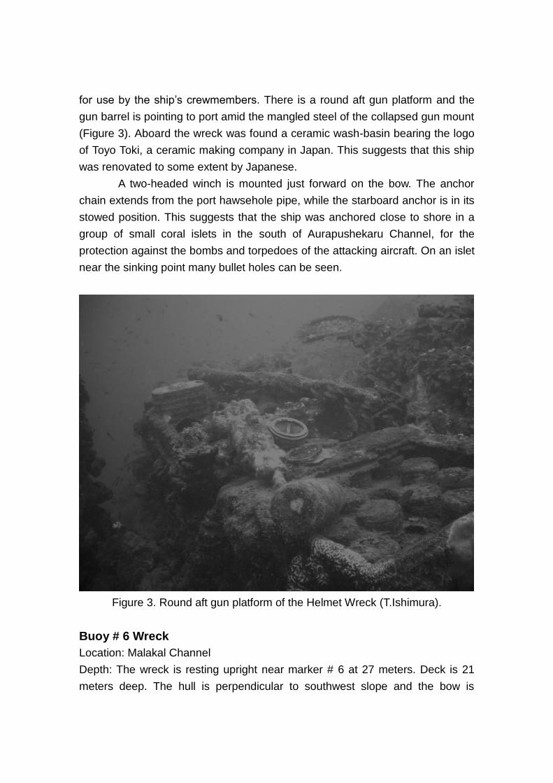
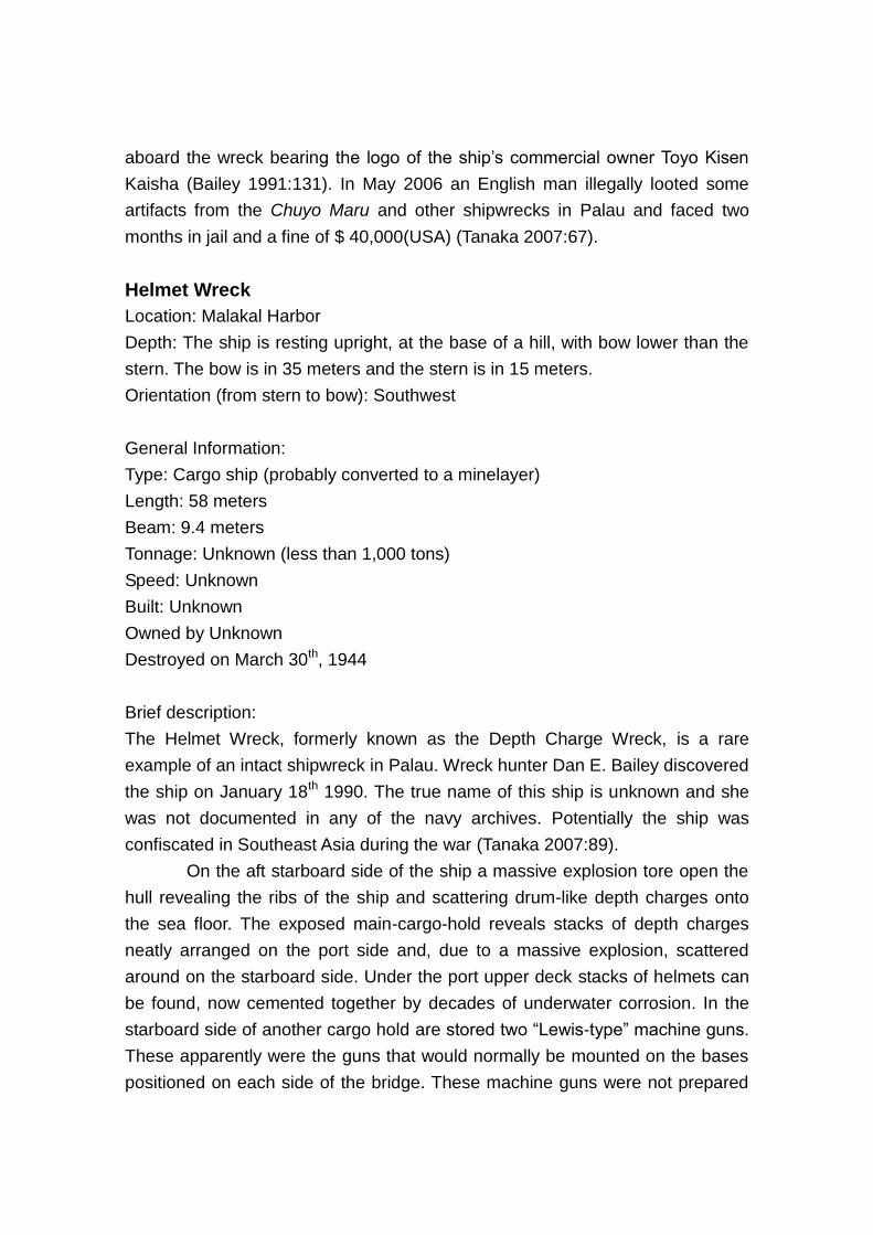
for use by the ship’s crewmembers. There is a round aft gun platform and the
gun barrel is pointing to port amid the mangled steel of the collapsed gun mount
(Figure 3). Aboard the wreck was found a ceramic wash-basin bearing the logo
of Toyo Toki, a ceramic making company in Japan. This suggests that this ship
was renovated to some extent by Japanese.
A two-headed winch is mounted just forward on the bow. The anchor
chain extends from the port hawsehole pipe, while the starboard anchor is in its
stowed position. This suggests that the ship was anchored close to shore in a
group of small coral islets in the south of Aurapushekaru Channel, for the
protection against the bombs and torpedoes of the attacking aircraft. On an islet
near the sinking point many bullet holes can be seen.
Figure 3. Round aft gun platform of the Helmet Wreck (T.Ishimura).
Buoy # 6 Wreck
Location: Malakal Channel
Depth: The wreck is resting upright near marker # 6 at 27 meters. Deck is 21
meters deep. The hull is perpendicular to southwest slope and the bow is
pointing to the northeast.
Orientation (from stern to bow): Northeast
General Information:
Type: Bonito fishing boat (probably converted to a submarine chaser)
Length: 30 meters
Tonnage: Unknown
Speed: Unknown
Built: Unknown
Owned by Unknown
Destroyed on March 30th, 1944
Brief description:
This small vessel known as Buoy #6 wreck was a bonito fishing boat converted
to a submarine chaser. The original name of this ship is unknown, and she is not
documented in any of the navy archives.
A pair of outlet conduits can be seen on the portside, which is a feature
of bonito fishing boats. A circular gun platform is mounted on the bow but the gun
is missing. Two sections of superstructure can be seen amidships.
A survivor of Iro related that he was rescued by a group of bonito fishing
boats from Yaizu, Shizuoka Prefecture in Japan (Tanaka 2007:87). It is a known
fact that, not only, commercial vessels but also many fishing boats were used for
military purposes during the War. The ship of Bouy # 6 may have been a
member of such a group.
Interpretations and discussion
The research on the wrecks revealed that most of the vessels sunken in Palau
were not main-force vessels of Japanese forces but auxiliary vessels and
converted vessels originally built for non-combat purposes. The Iro was not an
original military vessel but an oil tanker and was not suited for direct combat. In
addition, the ship was old and slow in speed. The Akashi was heavily damaged
by the attack in Truk and hardly managed to escape with the other vessels of the
fleet. The other vessels were not genuine military vessels but former commercial
vessels such as cargo ships and bonito fishing boats. Some of them have not
been documented in military records. This implies that the number of military
vessels were so insufficient that commercial vessels were used for military
purpose in the later part of the War.
These vessels were also “slow boats”. They were too slow to catch up
with other members of the fleet such as battleships, cruisers and destroyers.
They were left behind as a “third wheel” of the Combined Fleet.
Moreover, the vessels were not well-equipped for combat activity. Most
of them had only one or two gun turrets to fight against enemy aircrafts. Lack of
ammunition forced them to be engaged more difficult battles. Nonetheless, much
of the vessels anchored in the harbor and continued intercepting against
aircrafts until they sunk. Due to these factors it is considered that this was a
suicidal mission, as is the case with the “banzai” and “kamikaze” suicide
bombing attacks in battles on Peleliu and other islands in the Pacific region.
The evidence provided here demonstrates the difficulties and the
desperate campaign of the Japanese forces in the later part of the WWII. Studies
on shipwrecks and other war-associated sites will provide further evidence that
are thus far not known to exist in documents.
Underwater investigations on wrecks also indicate the importance of
documentation by underwater archaeological methods and implementation of
proper conservation management for the UCH in Palau. The vessels and
artifacts have deteriorated due to the combined causes of bombing, aging and
salvaging activities, therefore it is necessary to record the current state of
conservation of these properties. The Akashi site also needs to be protected, for
a number of artifacts are distributed in the debris field even though the vessel
itself has been removed. The Palauan government has designated the WWII
wrecks as cultural properties and protects them by law (UNESCO 2010:77);
however, some of them are still under threat by illegal treasure hunters, like the
case of the Chuyo Maru. Such looting activity is impermissible and must cease,
since it harms not only the cultural property of Palau but also the dignity of the
dead in the wrecks and the sentiments of the bereaved families in Japan.
Bibliography
Bailey, D. E.,
1991
WW II Wrecks of Palau, North Valley Diver Publications,
California.
Fish ’n Fins,
n.d.
D-log Palau (CD-ROM). Koror: Fish ’n Fins.
Ishimura, T.,
2005
“WW II archaeology and recovery of the remains: a case in
Palau”, paper presented at Inter-Congress in 2005, World
Archaeology Congress, World Archaeology Congress,
Osaka.
Ishimura, T.,
2010a
“Research on the WW II sites and the cultural heritages of
the Japanese Mandate Territory period in Palau”, in Bulletin
of Nara National Research Institute for Cultural Properties
2010, pp. 12-13. (in Japanese)
Ishimura, T.,
2010b
“Memories and sites of the war in Palau: archaeology and
recovery of Japanese soldier remains”, in Kindai Koko 66,
pp. 1-3. (in Japanese)
Tanaka, M.,
2007
Palau: Underwater Spirits of the War Dead, Namiki Shobo,
Tokyo.. (in Japanese)
UNESCO,
2010
Underwater Cultural Heritage in Oceania (edited by Ulrike
Guérin, Barbara Egger and Vidha Penalva). Paris:
UNESCO.
Yoshimura, A.,
1976
Navy Otsu Incident. Tokyo: Bungei Shunju. (in Japanese)