introduction - web viewthe norbe tool has different levels of authorisations for access to, and...
TRANSCRIPT

Neutral or Beneficial Effect on Water Quality
Assessment Tool
CONSULTANTS AND CONSULTANT ADMINISTRATORS
User Guide
2015
1

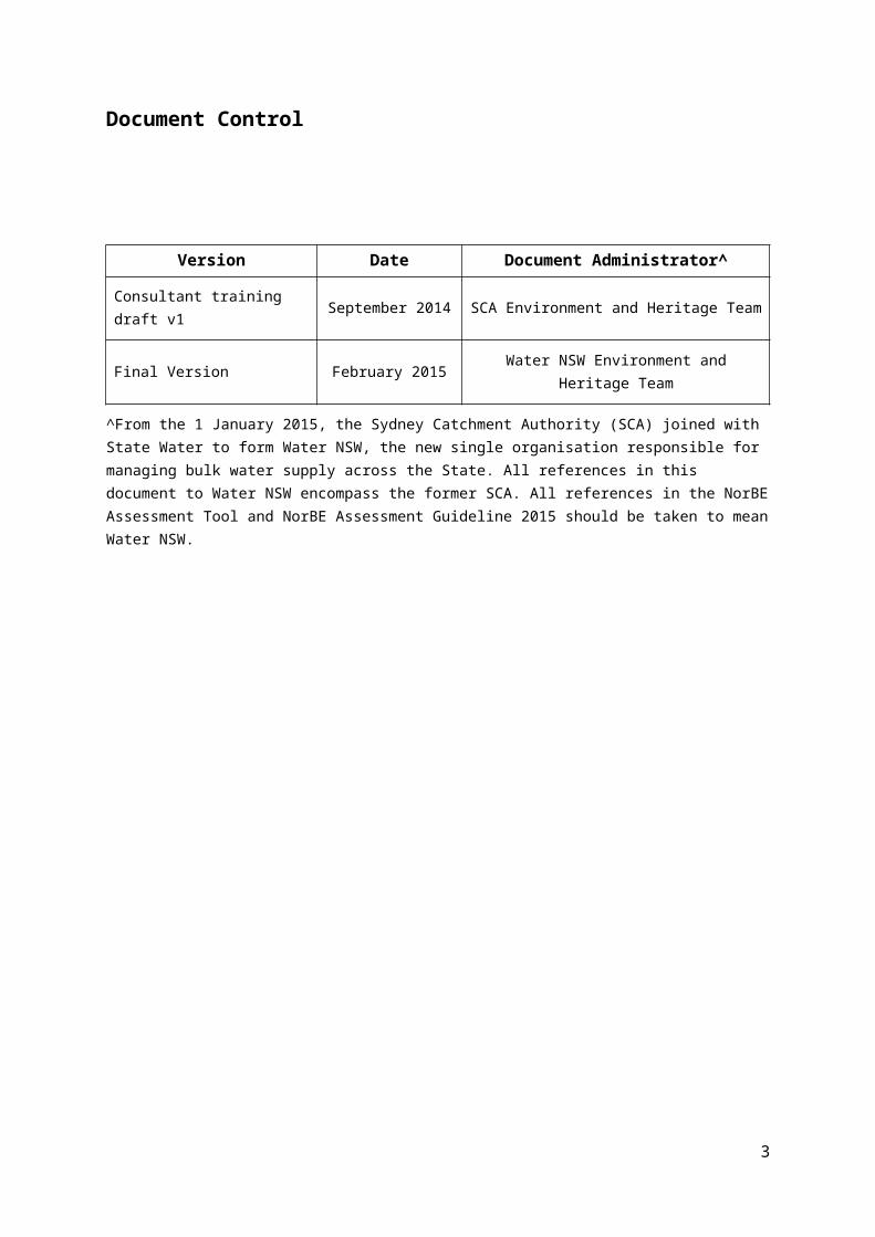
Document Control
Version Date Document Administrator^
Consultant training draft v1 September 2014 SCA Environment and Heritage Team
Final Version February 2015 Water NSW Environment and Heritage Team
^From the 1 January 2015, the Sydney Catchment Authority (SCA) joined with State Water to form Water NSW, the new single organisation responsible for managing bulk water supply across the State. All references in this document to Water NSW encompass the former SCA. All references in the NorBE Assessment Tool and NorBE Assessment Guideline 2015 should be taken to mean Water NSW.
2
Contents1. Introduction.................................................................................................................................... 5
1.1. About the NorBE Tool and User Guide.......................................................................................5
1.2. Why do a NorBE Assessment?...................................................................................................5
1.3. How the NorBE Assessment Process Works..............................................................................6
1.4. User Hints and Tips.................................................................................................................... 7
2. Getting Started............................................................................................................................... 8
2.1. Web Address.............................................................................................................................. 8
2.2. LogIn Screen.............................................................................................................................. 8
2.3. Registration/New User................................................................................................................9
2.4. Password.................................................................................................................................. 10
3. User Authorisations......................................................................................................................10
3.1. Consultant Administrators.........................................................................................................10
3.2. Consultants............................................................................................................................... 11
3.3. Approving New Users (Consultant Administrator).....................................................................11
4. Assessments Page......................................................................................................................12
4.1. In progress................................................................................................................................ 13
4.2. Lodged...................................................................................................................................... 13
4.3. Rework/Reassess..................................................................................................................... 13
4.4. My details.................................................................................................................................. 14
5. Creating a new assessment.........................................................................................................14
5.1. General..................................................................................................................................... 14
5.2. Lots........................................................................................................................................... 14
5.3. Mapping Viewer........................................................................................................................15
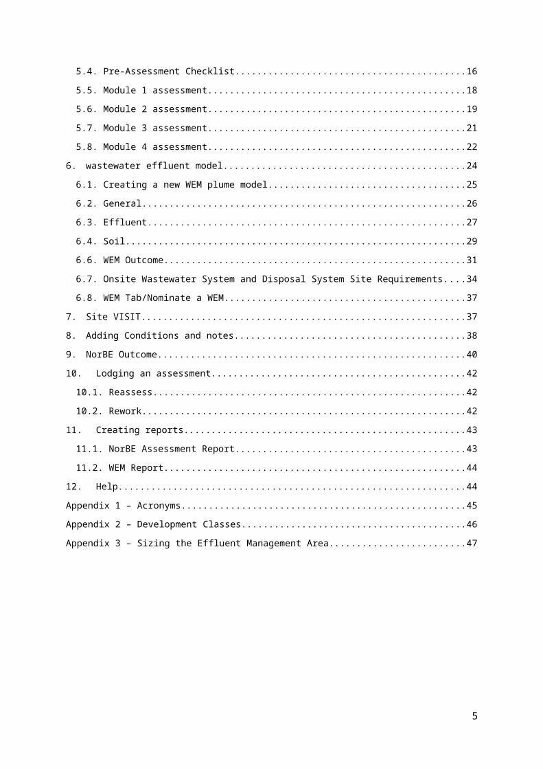
5.4. Pre-Assessment Checklist........................................................................................................16
5.5. Module 1 assessment...............................................................................................................18
5.6. Module 2 assessment...............................................................................................................19
5.7. Module 3 assessment...............................................................................................................21
5.8. Module 4 assessment...............................................................................................................22
6. wastewater effluent model...........................................................................................................24
6.1. Creating a new WEM plume model...........................................................................................25
6.2. General..................................................................................................................................... 26
6.3. Effluent...................................................................................................................................... 27
6.4. Soil............................................................................................................................................ 29
3

6.6. WEM Outcome......................................................................................................................... 31
6.7. Onsite Wastewater System and Disposal System Site Requirements......................................34
6.8. WEM Tab/Nominate a WEM.....................................................................................................37
7. Site VISIT..................................................................................................................................... 37
8. Adding Conditions and notes.......................................................................................................38
9. NorBE Outcome........................................................................................................................... 40
10. Lodging an assessment...........................................................................................................42
10.1. Reassess................................................................................................................................ 42
10.2. Rework.................................................................................................................................... 42
11. Creating reports....................................................................................................................... 43
11.1. NorBE Assessment Report.....................................................................................................43
11.2. WEM Report........................................................................................................................... 44
12. Help......................................................................................................................................... 44
Appendix 1 – Acronyms....................................................................................................................... 45
Appendix 2 – Development Classes....................................................................................................46
Appendix 3 – Sizing the Effluent Management Area............................................................................47
4
1. INTRODUCTION
1.1. ABOUT THE NorBE TOOL AND USER GUIDE
This user guide is designed to help you use the neutral or beneficial effect (NorBE)
assessment tool developed by Water NSW, formally the Sydney Catchment Authority (SCA).
It will take you through the assessment tool step by step, and includes information to help
you understand how:
- the NorBE assessment process works
- to get registered and log in
- to create, complete and save a NorBE assessment
- to run a wastewater effluent model (WEM) for development proposals in unsewered
areas
- to determine whether NorBE has been satisfied or not for your proposed
development, and if your development will need to be referred to Water NSW for
concurrence
- to produce a variety of reports for individual assessments.
The NorBE tool has been designed so that it will calculate some parameters automatically
requiring the minimal amount of your input, and prompts you when the proposal requires
referral to Water NSW for concurrence. The detailed decision making process that
underlines the tool is documented in the ‘Neutral or Beneficial Effect on Water Quality
Assessment Guideline 2015’. The guideline also provides relevant definitions and detailed
supporting information.
The NorBE tool has different levels of authorisations for access to, and use of, the tool by
consultants. Councils also have access to the tool.
The tool will not make information from your assessment available to other consultancies or
other third parties. Water NSW will be able to view council’s and consultant’s assessments
but will not be able to edit or modify them.
1.2. WHY DO A NorBE ASSESSMENT?
The tool is consistent with the requirements of State Environmental Planning Policy (Sydney
Drinking Water Catchment) 2011 (the SEPP) that became operational on 1 March 2011. The
SEPP requires all development in the catchment that requires consent to have a neutral or
beneficial effect on water quality and as such, requires a NorBE assessment to be
5
undertaken. The tool is also consistent with the Clause 64 Notice, dated February 2015,
issued to catchment councils by Water NSW. The Notice specifies the circumstances in
which Water NSW’s concurrence may be assumed.
Using the NorBE tool means you will be able to undertake a full NorBE assessment and
submit this to the relevant council, who will then review and ‘certify’ that the information is
correct and consistent with the development application documentation and site constraints.
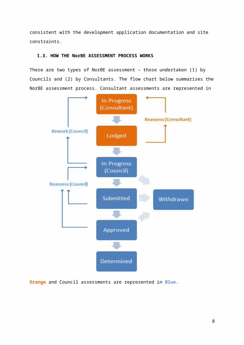
1.3. HOW THE NorBE ASSESSMENT PROCESS WORKS
There are two types of NorBE assessment – those undertaken (1) by Councils and (2) by
Consultants. The flow chart below summarises the NorBE assessment process. Consultant
assessments are represented in Orange and Council assessments are represented in Blue.
6
Consultants are able to reassess their own assessments that have been lodged until a
council opens the lodged assessment. Council can also send back Consultant assessments
for reworking.
1.4. USER HINTS AND TIPS
Hints and tips to make using the NorBE Assessment tool easier.
Step-by-step instructions to complete a section of the NorBE assessment process
are enclosed by a box in this user guide.
A link to this user guide is available on each screen of the NorBE tool.
Clicking Next when you’ve completed a screen will automatically save the
information you have provided up to that point and move you along to the next tab. If
you click Close before completing a screen or click on another tab, any information
you have entered on that screen will be lost.
All questions must be answered before progressing to the next screen. If you are
unsure hover over the icon for further information.
A dialog box such as the one below will appear if NorBE will not be satisfied or Water
NSW (the former SCA) concurrence is required.
Use the Filter function on the Assessments Screen to search for a specific
assessment. Assessments can be filtered by information in any of the columns on
this screen including: reference number, date created and the person who created
the assessment. Using the filter function will only filter assessments that are in that
tab.
Use the Sort function by clicking on a column heading in the Assessments Screen to
sort the assessments by that column.
When creating a wastewater effluent model (WEM) use the Enlarge Map button to
view the map on a larger screen. Click close or escape to return to the previous
screen.
7
A Note must be added to the dialog box when sending an assessment back for
reassessment.
When closing an assessment from the Lodged tab you’ll automatically be taken back
to the In Progress screen.
For technical help with the tool please email [email protected].
For general enquiries regarding NorBE assessments for DAs please contact an
officer from Water NSW’s Planning and Assessments team on 02 4724 2400.
2. GETTING STARTED
2.1. WEB ADDRESS- To access the NorBE tool go to: https://norbe.sca.nsw.gov.au
2.2. LOGIN SCREEN
- Click the Login button to log in and enter your password.
- Checking the Remember me box will enable windows to automatically remember
your password.
- If you have forgotten your password, click the Forgot Password? button and re-
submit your email address using the Send verification email button. Open the
verification email and follow instructions for resetting your password.
- You can also contact Water NSW for assistance using the Help Desk email link on
the Login Screen.
8

Log In Screen
Email Verification Screen:
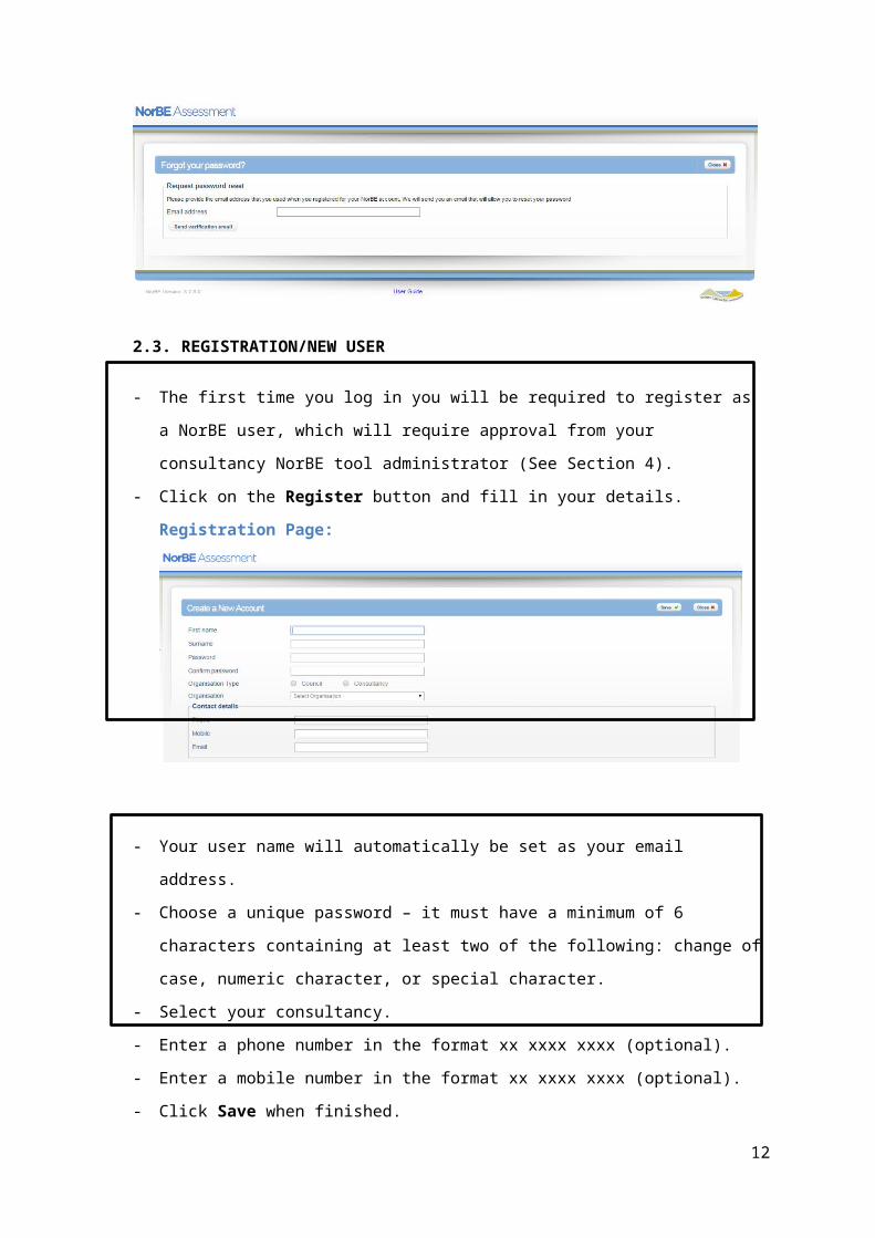
2.3. REGISTRATION/NEW USER
- The first time you log in you will be required to register as a NorBE user, which will
require approval from your consultancy NorBE tool administrator (See Section 4).
- Click on the Register button and fill in your details.
Registration Page:
9

- Your user name will automatically be set as your email address.
- Choose a unique password – it must have a minimum of 6 characters containing at
least two of the following: change of case, numeric character, or special character.
- Select your consultancy.
- Enter a phone number in the format xx xxxx xxxx (optional).
- Enter a mobile number in the format xx xxxx xxxx (optional).
- Click Save when finished.
When you submit your registration an email will be sent to your consultancy’s NorBE tool
administrator who will either approve or decline your request for access. You will be notified
by email of the result of your request. If your consultancy does not already have an
administrator, you will need to contact Water NSW to organise access to the tool.
Your NorBE tool administrator can assist you with queries regarding your user details and
level of authorisation within the tool (See Section 4).
2.4. PASSWORD
2.4.1. CHANGE PASSWORD
- To change your password click Change Password from the My Details tab.
- You will need your existing password to do so.
3. USER AUTHORISATIONS
There are two levels of authorisations for consultants to access and use the NorBE tool.
These are Consultant Administrator and Consultant. These levels of authorisation are
outlined below:
3.1. CONSULTANT ADMINISTRATORS
- Can view and update all assessments within their consultancy.
- Can copy and delete any assessment within their consultancy.
- Can only create, update or delete notes they have created.
- Can lodge any assessment created by their consultancy.
- Can reassess any assessment lodged by a consultant.
- Can approve/decline users within their consultancy.
10

3.2. CONSULTANTS
- Can view and update all assessments within their consultancy.
- Can copy and delete any assessment within their consultancy.
- Can only create, update or delete notes they have created.
- Can lodge any assessment created by their consultancy.
- Can reassess any assessment lodged by a consultant.
3.3. APPROVING NEW USERS (CONSULTANT ADMINISTRATOR)
Consultant Administrators have access to a User tab from the Assessments Screen that
will allow them to view details of all NorBE users within their consultancy. When a new
consultant user registers as a NorBE user, the Consultant Administrator will receive an email
notification prompting them to approve the new user. The new consultant user will also
receive an email once the Consultant Administrator either approves or rejects their request.
The list of users will show the users’ display name, role and status. Clicking on a user name
in the list will show more of that user’s details.
Consultant Administrator – Update User’s Details:
It is also possible for Consultant Administrators to Deactivate an account from the Users
menu. Once an account has been deactivated it is not possible to reactivate the account.
Consultant Administrators can still view and edit the deactivated user’s assessments for
lodging.
4. ASSESSMENTS PAGE
Once you log in you will be taken to the Assessments screen. Two categories of
Development Applications (DAs) are available for viewing from the Assessments screen.
These are: In Progress (the default screen) and Lodged. These can be viewed by clicking
on the relevant tab in the menu on the left hand side of the screen.
11
There is also a series of tabs along the top of the screen, Assessments, and My Details.
Consultant Administrators will also have access to a User tab from here that will allow them
to view all NorBE users within their consultancy (see Section 3).
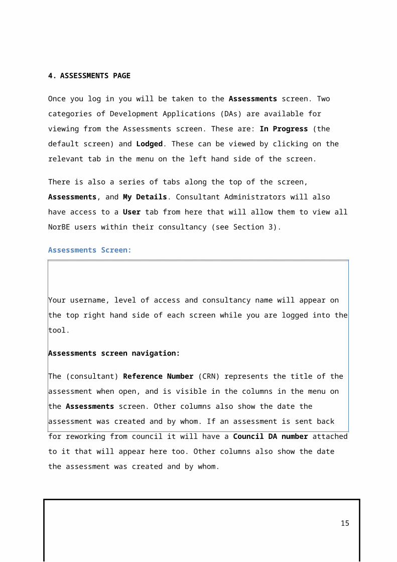
Assessments Screen:
Your username, level of access and consultancy name will appear on the top right hand side
of each screen while you are logged into the tool.
Assessments screen navigation:
The (consultant) Reference Number (CRN) represents the title of the assessment when
open, and is visible in the columns in the menu on the Assessments screen. Other columns
also show the date the assessment was created and by whom. If an assessment is sent
back for reworking from council it will have a Council DA number attached to it that will
appear here too. Other columns also show the date the assessment was created and by
whom.
- To start new assessments click the New button in the bottom right hand corner of the
screen (for further details on creating a new assessment see Section 5).
- To open an existing assessment either select the assessment using the radio button
next to the DA number for that assessment and click Open, or click on the relevant
DA number. - To copy an assessment click the radio button next to the DA number and click Copy.
- To delete an assessment click the radio button next to the DA number and click
Delete.
- To Filter the list of assessments on the Assessment screen, type the DA number in
the Filter by box at the top right of the screen. Information from any column can be
used to filter assessments.
- To Sort the list of assessments on the Assessments screen, click on any column
heading.
4.1. IN PROGRESS
12
Once you have created a new assessment or if you are returning to continue an assessment
it will sit in the In Progress screen. Click on the relevant reference number or alternatively
you can select the assessment using the radio button and click the Open button.
4.2. LODGED
Once an assessment is lodged by a Consultant it will appear in the Lodged screen for
further assessment by council. Once an assessment has been lodged it cannot be deleted
but can still be copied. Once a council opens your lodged assessment, it will disappear from
the Lodged screen and you will no longer be able to view it.
4.3. REWORK/REASSESS
An assessment lodged by a Consultant is ‘read-only’ for council users and cannot be edited
or updated. It will therefore be sent back by council for reworking if further amendments are
required, and will re-appear in the In Progress screen. It will now also have a Council DA number attached to it. You will receive an email notification if your assessment is sent back
by council for reworking.
Similarly a Consultant or Consultant Administrator is able to return an assessment to the In Progress screen if amendments need to be made by using the Reassess button from the
lodged state (but only before Council opens the assessment).
4.4. MY DETAILS
- To enter or edit your personal details, including your name and contact details, click
on the My Details tab. Click on the Save button to save any changes you make.
5. CREATING A NEW ASSESSMENT
5.1. GENERAL
- To create a new assessment click New on the Assessments screen.
- Under the General tab you will need to enter a Consultant Reference Number
(maximum 40 characters, no restriction on type of character) and a Modification Number if relevant to the application.
- Select the Council to which the assessment will be submitted.
13
- Click Next to save the assessment to the In Progress list of DAs, and click Next to
move to the Lots screen.
- Click Close to return to the Assessments screen.
General Tab:
The Consultant Reference Number will then appear as the screen title in the blue banner.
5.2. LOTS
- Enter the Lot, Section and DP information and click Add Lot. If there is no Section
number then leave this field blank.
- This information then appears in the reference list.
- If more than one lot is involved in the DA you can enter the Lot, Section and DP
information, clicking on the Add Lot button each time until the list is complete.
- To remove a lot from the list click the radio button next to the lot you want to remove and
click the Remove button.
- If you are dealing with a Strata Plan then only put in the Plan number.
- When all relevant lots are added click Next to be taken to the Pre-Assessment tab.
- See Section 5.3 on how to use the mapping viewer.
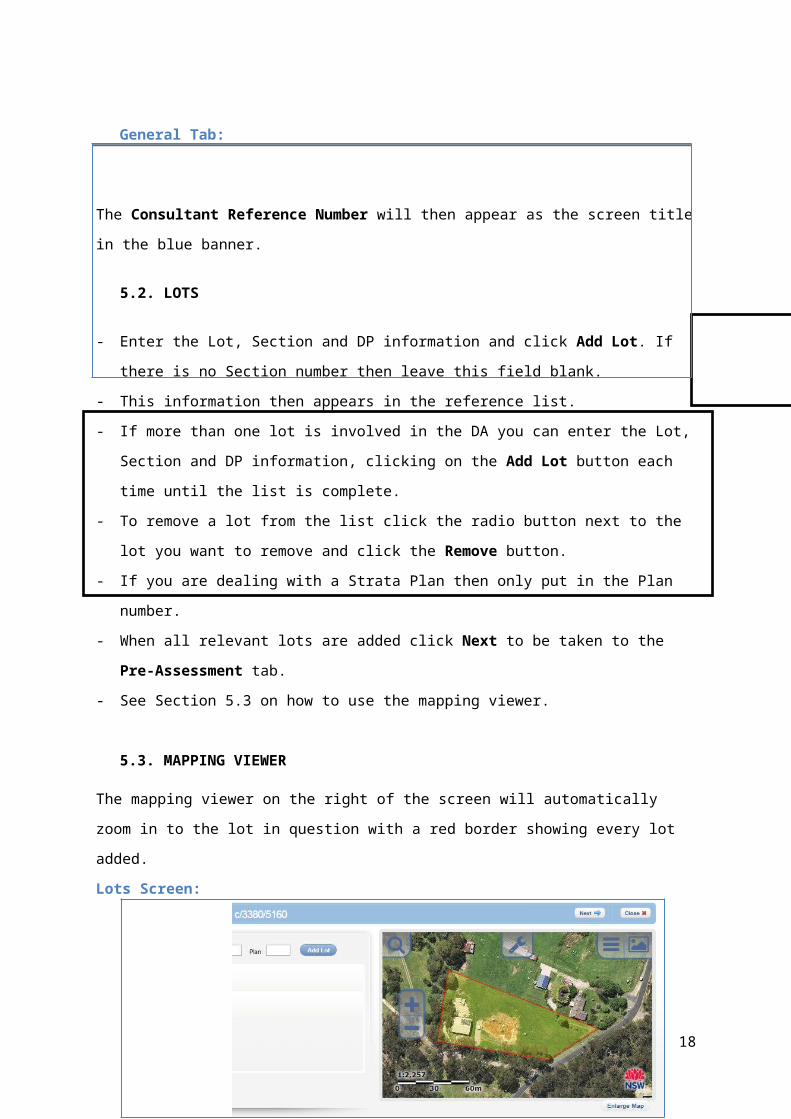
5.3. MAPPING VIEWER
The mapping viewer on the right of the screen will automatically zoom in to the lot in
question with a red border showing every lot added.
Lots Screen:
14
- Click Enlarge Map to enlarge the map to fill the whole screen. Click Escape or the Close
button to return to the previous screen.
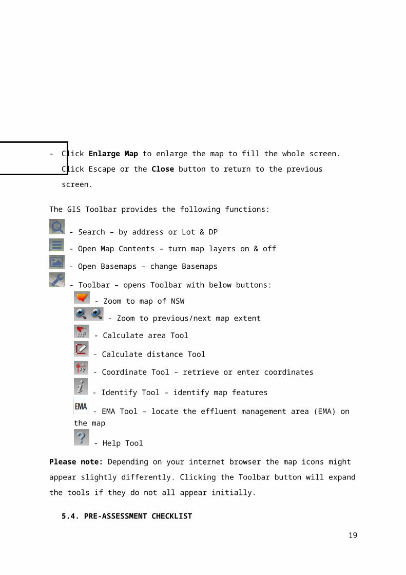
The GIS Toolbar provides the following functions:
- Search – by address or Lot & DP
- Open Map Contents – turn map layers on & off
- Open Basemaps – change Basemaps
- Toolbar – opens Toolbar with below buttons:
- Zoom to map of NSW
- Zoom to previous/next map extent
- Calculate area Tool
- Calculate distance Tool
- Coordinate Tool – retrieve or enter coordinates
- Identify Tool – identify map features
- EMA Tool – locate the effluent management area (EMA) on the map
- Help Tool
Please note: Depending on your internet browser the map icons might appear slightly
differently. Clicking the Toolbar button will expand the tools if they do not all appear initially.
5.4. PRE-ASSESSMENT CHECKLIST
The Pre-Assessment checklist is the beginning of the NorBE assessment decision making
process. The Pre-Assessment questions that must be answered for every NorBE
assessment are on this screen. Entering all the relevant information into the Pre-Assessment
checklist will help determine:
if you need to continue to use the NorBE tool for a Module 1, Module 2, Module 3 or
Module 4 assessment
whether information may be missing from the application
whether the application will be referred to Water NSW for concurrence.
To complete the Pre-Assessment checklist complete the following steps:
15

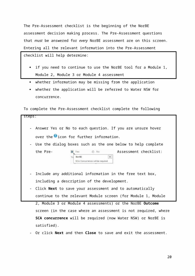
- Answer Yes or No to each question. If you are unsure hover over the icon for
further information.
- Use the dialog boxes such as the one below to help complete the Pre-Assessment
checklist:
- Include any additional information in the free text box, including a description of the
development.
- Click Next to save your assessment and to automatically continue to the relevant
Module screen (for Module 1, Module 2, Module 3 or Module 4 assessments) or the
NorBE Outcome screen (in the case where an assessment is not required, where
SCA concurrence will be required (now Water NSW) or NorBE is satisfied).
- Or click Next and then Close to save and exit the assessment.
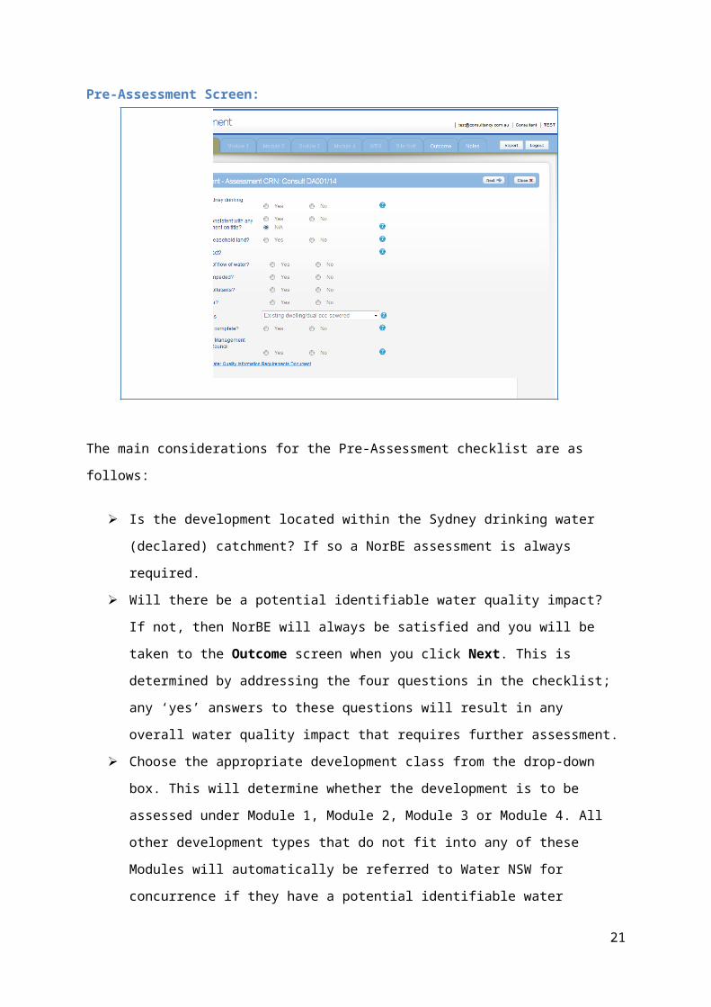
Pre-Assessment Screen:
The main
considerations for the Pre-Assessment checklist are as follows:
Is the development located within the Sydney drinking water (declared) catchment? If
so a NorBE assessment is always required.
Will there be a potential identifiable water quality impact? If not, then NorBE will
always be satisfied and you will be taken to the Outcome screen when you click
Next. This is determined by addressing the four questions in the checklist; any ‘yes’
16

answers to these questions will result in any overall water quality impact that requires
further assessment.
Choose the appropriate development class from the drop-down box. This will
determine whether the development is to be assessed under Module 1, Module 2,
Module 3 or Module 4. All other development types that do not fit into any of these
Modules will automatically be referred to Water NSW for concurrence if they have a
potential identifiable water quality impact. For further information on development
classes and Modules in the NorBE tool, please refer to the ‘NorBE Assessment
Guideline 2015’. A more detailed description of the development types and which
modules they correspond to is provided in Appendix 2.
The Pre-Assessment cannot continue if all the documentation is not complete. It is
essential that all documentation is available to be reviewed.
It is also important that the documentation provided with the DA is also consistent
with Water NSW’s and the council requirements for water cycle management studies
(WCMS). A link to the document detailing the requirements is available from the Pre-Assessment screen.
5.5. MODULE 1 ASSESSMENT
After completing the Pre-Assessment checklist, the NorBE tool will automatically take you to
the Module 1 screen for development classes in that module. As a rule Module 1
developments are urban dwellings or small urban subdivisions (less than four lots).
To complete a Module 1 assessment, work through the following steps:
- Enter a value greater than 0 for the Impervious area and Construction area (both
in square metres and as a whole number). The size of the area will help determine
whether Water NSW concurrence is required or what conditions will be placed on the
development.
- Click the radio button to select whether an adequate SSSQM certificate has been
provided (at present this is not required and the question is defaulted to ‘N/A’), the
development site slope is lesser or greater than 20%, whether it’s within 1% of AEP
flood level or flood prone land, and whether there are any other site constraints.
- If appropriate management measures have been proposed to address any other site
constraints tick the box (otherwise NorBE will not be satisfied).
- Click Next to be taken to the Outcome tab once you have answered all Module 1
questions (see Section 9 for further detail on the Outcome tab).
17
- Click the Report button to download an assessment report in PDF format in a
separate window, which will provide all details entered for the assessment. This can
be downloaded at any stage during the assessment. You can either save this
electronically or print a hard copy see Section 11 for more details).
Module 1 Screen:
18
The main considerations when completing a Module 1 assessment are as follows:
A value of greater than zero must be entered for the impervious and construction
areas otherwise an error message will be displayed. Water NSW concurrence will be
required if the impervious or construction areas are 2,500 m2 or greater.
Water NSW strongly discourages development on sites with slopes greater than 20%
and a condition will automatically be set for developments that have slopes greater
than 20%.
If there are other site constraints NorBE will not be satisfied unless appropriate
management measures have been proposed.
Use site plans and aerial photography, and confirm information in the DA through a
site inspection (see Section 7).
5.6. MODULE 2 ASSESSMENT
After completing the Pre-Assessment checklist, the NorBE tool will automatically take you to
the Module 2 screen for development classes in that module. As a rule Module 2
developments are rural dwellings and small rural subdivisions (less than 4 lots).
To complete a Module 2 assessment, complete the following steps:
- Choose the Development site slope from the drop-down list.
- Enter a value greater than 0 for the Construction area (in square metres and as a
whole number). The size of the area will determine whether Water NSW concurrence
is required or what condition will be places on the development.
- Choose a radio button option (Yes or No or N/A) to each question.
19
- Ensure that you address any issues if the following dialog box appears, this usually
occurs when secondary questions appear where a site issue has been identified.
- Once you’ve answered all Module 2 questions click Next. This will usually take you to
the wastewater effluent model (WEM) tab (see Section 6 for further detail on the
WEM); otherwise the tool will take you directly to the Outcome tab (see Section 9 for
further detail on the Outcome tab).
- Click the Report button to download an assessment report in PDF format in a
separate window, which will provide all details entered for the assessment. This can
be downloaded at any stage during the assessment. You can either save this
electronically or print a hard copy (see Section 11 for more detail).
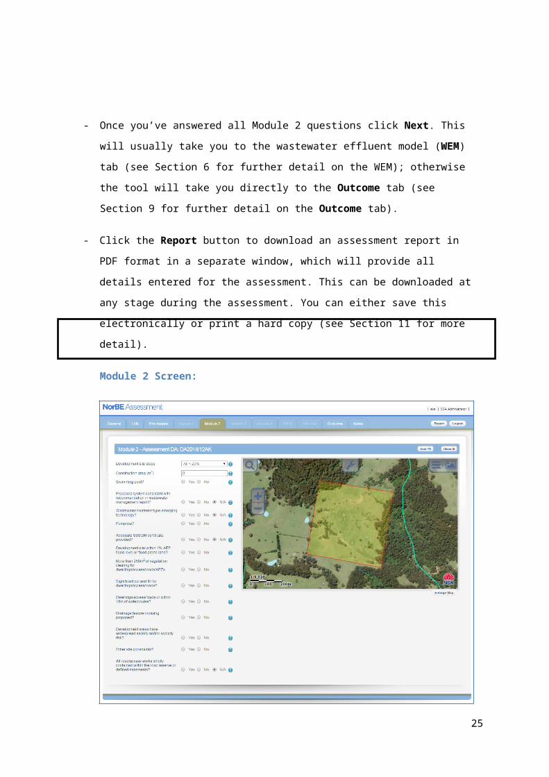
Module 2 Screen:
The main considerations when completing a Module 2 assessment are as follows:
20
Water NSW strongly discourages development on sites with slopes greater than 20%
and a condition will automatically be set for developments that have slopes greater
than 20%.
Water NSW concurrence will be required if the construction area is greater than
2,500 m2.
Water NSW does not support pump-out systems unless it is proposed in an area that
is likely to be sewered in the near future. In the event that there is no other viable on-
site wastewater system and/or council DCP allows for pump-outs, contact Water
NSW for advice.
If there are other site constraints NorBE will not be satisfied unless appropriate
management measures have been proposed. Use site plans and aerial photography,
and confirm information through a site inspection (see Section 7).
5.7. MODULE 3 ASSESSMENT
After completing the Pre-Assessment checklist, the NorBE tool will automatically take you to
the Module 3 screen for development classes in that module. As a rule Module 3
developments are large urban subdivisions (4 lots or more).
To complete a Module 3 assessment, complete the following steps:
- Chose the Development Site Slope from the drop down list.
- Select a radio button option (Yes or No or N/A) to each question, including whether
the development site is within 1% AEP flood level or flood prone land.
- Select a radio button option (Yes or No or N/A) to each question within the Sewerage
Risks, Stormwater Modelling Analysis and Site Observation sections.
- You will be required to use the MUSIC software to assess stormwater impacts and
management measures unless the proposed impervious area is less than 2,500 m2,
then you may use the SSSQM Model instead (refer to Water NSW’s ‘Using MUSIC in
Sydney’s Drinking Water Catchment’ guide (published by the former SCA)).
- Ensure that you address any issues if the following dialog box appears:
- Click Next to be taken to the Outcome tab once you’ve answered all Module 3
questions (see Section 9 for further detail on the Outcome tab).
- Click the Report button to download an assessment report in PDF format in a
separate window, which will provide all details entered for the assessment. This can
21
be downloaded at any stage during the assessment. You can either save this
electronically or print a hard copy.
Module 3 Screen:
The main considerations when completing a Module 3 assessment are as follows:
Water NSW strongly discourages developments on sites with slopes greater than
20%.
If there are other site constraints NorBE will not be satisfied unless appropriate
management measures have been proposed. Use site plans and aerial photography,
and confirm through a site inspection (see Section 7).
Ensure you complete a site inspection before finalising the assessment to confirm the
desk top assessment accurately reflects the site.
The capacity of council’s sewerage system infrastructure has to be considered for
large subdivisions.
A Module 3 assessment will always need to be referred to Water NSW for
concurrence.
5.8. MODULE 4 ASSESSMENT
22
After completing the Pre-Assessment checklist, the NorBE tool will automatically take you to
the Module 4 screen for development classes in that module. Module 4 developments are
large rural subdivisions (4 lots or more).
To complete a Module 4 assessment, complete the following steps:
- Choose the Development site slope from the drop down list.
- Select a radio button option (Yes or No or N/A) to each question, including whether
the development site is within 1% AEP flood level or flood prone land.
- Select a radio button option (Yes or No or N/A) to each question within the
Stormwater Modelling Analysis Section.
- You will be required to use the MUSIC software to assess stormwater impacts and
management measures unless the proposed impervious area is less than 2,500 m2,
then you may use the SSSQM Model instead (refer to the guide ‘Using MUSIC in
Sydney’s Drinking Water Catchment’ published by the former SCA).
- Ensure that you address any issues if the following dialog box appears:
- Once you’ve answered all Module 4 questions click Next. If necessary this will take
you to the wastewater effluent model (WEM) tab (see Section 6 for further detail on
the WEM), or otherwise will take you to the Outcome tab (see Section 9 for further
detail on the Outcome tab).
- Click the Report button to download an assessment report in PDF format in a
separate window, which will provide all details entered for the assessment. This can
be downloaded at any stage during the assessment. You can either save this
electronically or print a hard copy.
Module 4 Screen:
23
The main considerations when completing a Module 4 assessment are as follows:
Water NSW strongly discourages development on sites with slopes greater than
20%.
The development must be consistent with the guide ‘Using MUSIC in Sydney’s
Drinking Water Catchment’, published by the former SCA.
Ensure you complete a site inspection before finalising the assessment to confirm the
desk top assessment accurately reflects the site.
If there are other site constraints NorBE will not be satisfied unless appropriate
management measures have been proposed. Use site plans and aerial photography,
and confirm through a site inspection (see Section 7).
The WEM will need to be used to ensure that all lots can appropriately manage on-
site wastewater taking into consideration site constraints.
A Module 4 assessment will always need to be referred to Water NSW for
concurrence.
6. WASTEWATER EFFLUENT MODEL
One of the key features of the NorBE tool is the wastewater effluent model (WEM).
The WEM models the predicted extent of an effluent plume from an on-site effluent disposal
system and allows a visual interpretation and assessment of the potential impact of a
development on water quality. Specifically, the WEM models the direction and distance that
three contaminants (faecal coliforms, nitrogen and phosphorus) will travel within the soil sub-
24
surface beyond the edge of the effluent management area (EMA) to the point where
contaminant concentrations reach a pre-determined threshold level. The resulting output is
three different plumes displayed visually on the map.
The model is run over a 25 year time period at 2.5 metre increments over a maximum
distance of 250 metres. In addition, the model is a ‘stochastic’ model, which means that it is
not run just once, but 100 times to enable the model outcomes to be reviewed in terms of
confidence limits rather than absolute values. The outcome values (ie the plume distances
you see visually displayed on the map) represent the 95%ile.
The WEM also contains a front end design component that ensures that effluent disposal
areas meet the minimum area requirements of AS/NZS 1547:2012.
Site conditions and constraints will affect what on-site wastewater system and effluent
disposal system will be appropriate. See tables in Section 6.7 that outline the site limitations
associated with on-site wastewater and effluent disposal systems to help you determine
whether a system is appropriate for the specific site conditions. If an inappropriate system is
selected for the site conditions, the tool will notify the user of this and they cannot proceed
with running a model. Discussions will need to take place with the proponent to consider a
more suitable system or location. These tables should be referred to when considering the
proposed development and when undertaking a site inspection to confirm site conditions and
constraints.
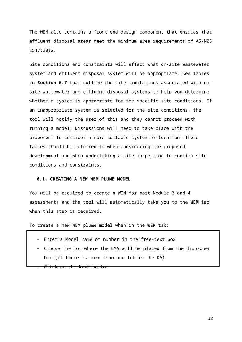
6.1. CREATING A NEW WEM PLUME MODEL
You will be required to create a WEM for most Module 2 and 4 assessments and the tool will
automatically take you to the WEM tab when this step is required.
To create a new WEM plume model when in the WEM tab:
- Enter a Model name or number in the free-text box.
- Choose the lot where the EMA will be placed from the drop-down box (if there is
more than one lot in the DA).
- Click on the Next button.
25
Create a New WEM Plume Model Screen:
Also note that for rural subdivisions, more than one WEM will need to be created to ensure
that on-site wastewater disposal can meet NorBE within each of the proposed lots (or groups
of lots where the soils and site constraints are similar), and to identify where a restriction to
the title may require for on-site treatment and/or disposal system type or location of the
system.
You will then be required to enter data into four screens that require input and appear as
tabs across the top of the screen.
6.2. GENERAL
The first screen is the General tab, which is the default screen for the model. This displays
the Model name, any Model description you enter, the Date saved and the chosen lot
over an aerial photo. It also allows you to locate the EMA. The process on locating the EMA
and how to move an EMA is also explained on the screen.
- To choose a site on the lot to place the EMA, click on the EMA icon from the tool bar
and place the marker on the lot in the desired location.
The location of the marker will represent the midpoint of the downslope edge of the EMA (ie
the middle of the lowest boundary of the EMA). Once the EMA is located, GIS information for
this specific location is called up and the General screen will expand to display this
information, including slope, easting and northing from the GIS.
PLEASE NOTE: If a slope value of greater than 20% is displayed, this will not be suitable for
an EMA. While you can continue with the assessment in such instances, you will not be able
to run the model unless you confirm, based on the site inspection, that the slope is in fact
suitable for the chosen system(s) (this will be located on the WEM Outcome Tab).
The tool then requires you to choose the distance of the EMA to any drainage depressions,
watercourses and groundwater bores from the drop down boxes – use the distance
26
measuring tool in the toolbar if you are unsure. The distance represents the overland flow
path.
PLEASE NOTE: If you select an ‘EMA distance to’ range below the minimum threshold for
that feature, then the NorBE tool WEM Outcome will be ‘Not Satisfied’ and you cannot run
the WEM Model, and the NorBE Outcome will also be ‘Not Satisfied’ for this model if
nominated as the final model considered in the assessment.
Locate your EMA:
6.3. EFFLUENT
Once you have located the EMA and completed the General screen, click the Next button
and the NorBE tool will take you to the Effluent screen (the next ‘tab’ along). On the
Effluent screen, you need to enter information about:
- the development, including Development type, Number of bedrooms and Water
supply type in order to calculate the design wastewater load
PLEASE NOTE: while you will be asked to enter in the proposed wastewater load, it
is the calculated design wastewater load that will be used for modelling purposes,
although both volumes will appear on the WEM report.
- the Treatment system (choose from a drop-down box)
- whether the system will be used continuously (defaulted to ‘Yes’)
27

- the Effluent disposal system (choose from a drop-down box that automatically
corresponds to the treatment system selected) proposed size of the EMA and
proposed number of trenches (where relevant)
- the EMA site Vegetation for nutrient uptake
- other site information such as whether the site is subject to severe frosts (defaulted
to ‘No’).
PLEASE NOTE: Lot size will sometimes be automatically displayed from the GIS, however
if this comes up as zero, you should manually enter in the lot size – use the ‘Area tool’ from
the toolbar to measure the lot size.
It is important to note that the WEM will not run when the proposed EMA:
is less than the minimum required EMA consistent with AS/NZS 1547:2012
exceeds the practicable maximum EMA (see Table 6.3.1)
a trench length exceeds the maximum allowable length of 20 metres.
Refer to Appendix 3 for further detail on sizing the EMA for irrigation and other systems.
The NorBE tool will generate a message (either on the Effluent tab or the WEM Outcome
tab) notifying the user when the above situations occur and the user will be required to
change the proposed area or system type, otherwise the WEM will not be allowed to run.
This check is done immediately for the trench length, and at the WEM Outcome tab for the
minimum and maximum EMA.
WEM Effluent Tab:
Table 6.3.1 – Maximum Allowable EMA Areas
28

Disposal System Type Maximum Allowable EMA Area (m2)Absorption trench 150Absorption bed 200ETA bed 250Sand mound 250Amended soil mound 250Surface irrigation 1500Sub-surface irrigation 1500
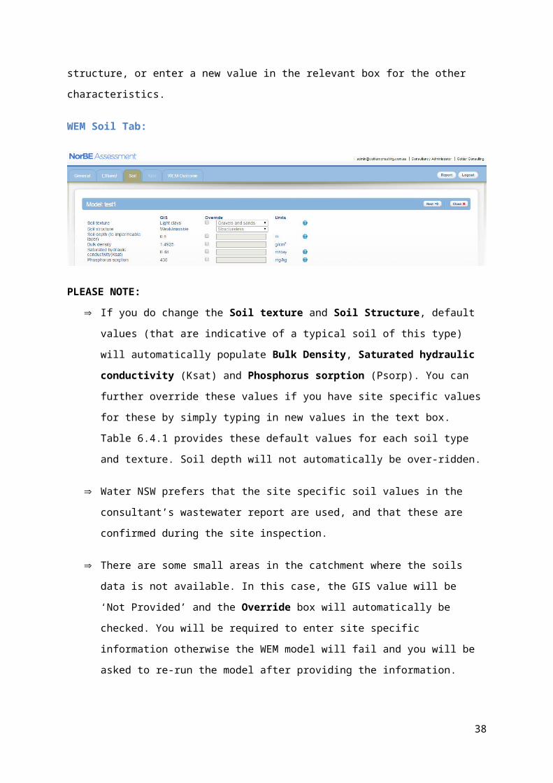
6.4. SOIL
Once you have completed the Effluent screen, click on the Next button. The NorBE tool will
take you to the Soil screen (the next ‘tab’ along). The Soil screen displays the
characteristics of the soil at your chosen EMA location, derived from GIS values based on
the soil facets layer developed by the former SCA and DLWC. You can either use these
values or override them if site specific information is available in your consultant’s report –
tick the Override box and type in the value in the corresponding text box. If you do choose
to override the GIS value, you will need to either choose a value from the drop-down box for
soil texture and structure, or enter a new value in the relevant box for the other
characteristics.
WEM Soil Tab:
PLEASE NOTE: If you do change the Soil texture and Soil Structure, default values (that are
indicative of a typical soil of this type) will automatically populate Bulk Density,
Saturated hydraulic conductivity (Ksat) and Phosphorus sorption (Psorp). You
can further override these values if you have site specific values for these by simply
typing in new values in the text box. Table 6.4.1 provides these default values for
each soil type and texture. Soil depth will not automatically be over-ridden.
29
Water NSW prefers that the site specific soil values in the consultant’s wastewater
report are used, and that these are confirmed during the site inspection.
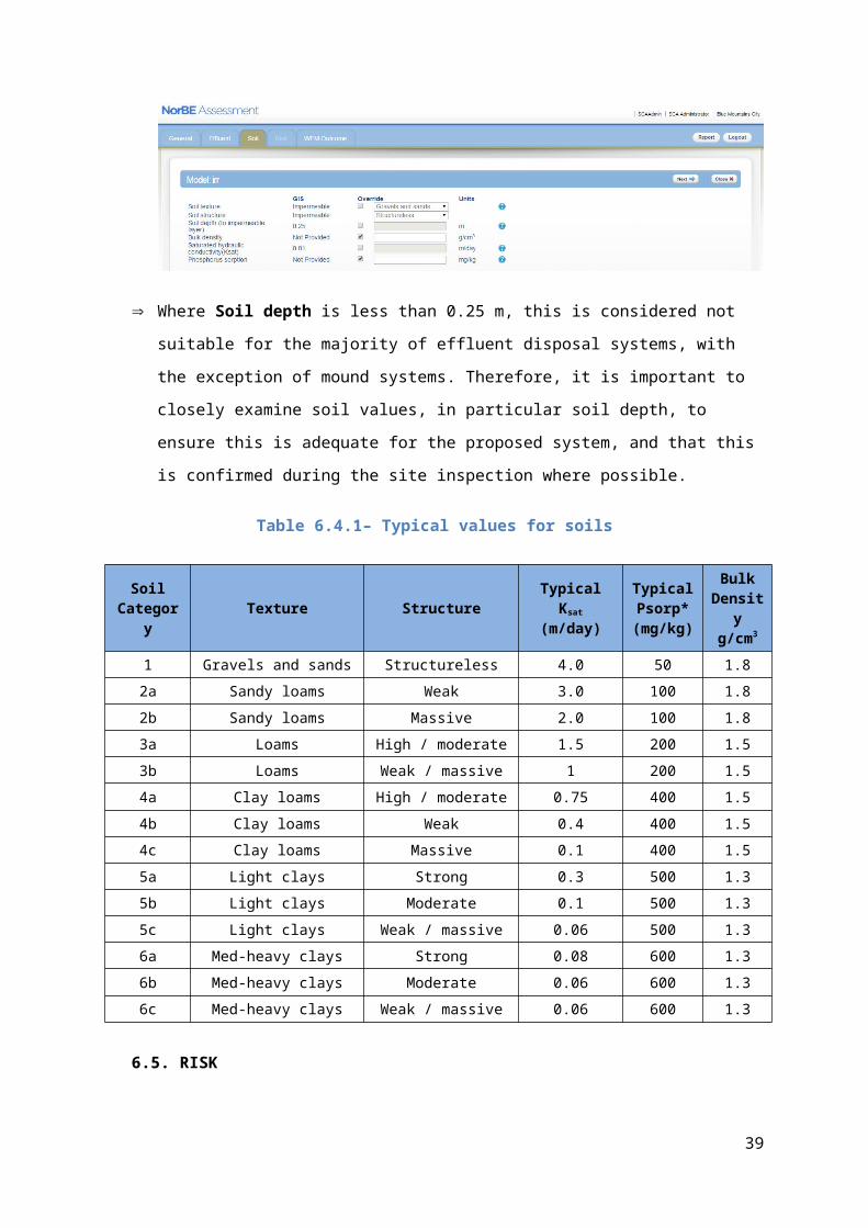
There are some small areas in the catchment where the soils data is not available. In
this case, the GIS value will be ‘Not Provided’ and the Override box will
automatically be checked. You will be required to enter site specific information
otherwise the WEM model will fail and you will be asked to re-run the model after
providing the information.
Where Soil depth is less than 0.25 m, this is considered not suitable for the majority
of effluent disposal systems, with the exception of mound systems. Therefore, it is
important to closely examine soil values, in particular soil depth, to ensure this is
adequate for the proposed system, and that this is confirmed during the site
inspection where possible.
Table 6.4.1– Typical values for soils
Soil Category Texture Structure Typical Ksat
(m/day)Typical Psorp* (mg/kg)
Bulk Density g/cm3
1 Gravels and sands Structureless 4.0 50 1.82a Sandy loams Weak 3.0 100 1.82b Sandy loams Massive 2.0 100 1.83a Loams High / moderate 1.5 200 1.53b Loams Weak / massive 1 200 1.54a Clay loams High / moderate 0.75 400 1.54b Clay loams Weak 0.4 400 1.54c Clay loams Massive 0.1 400 1.55a Light clays Strong 0.3 500 1.35b Light clays Moderate 0.1 500 1.35c Light clays Weak / massive 0.06 500 1.36a Med-heavy clays Strong 0.08 600 1.36b Med-heavy clays Moderate 0.06 600 1.36c Med-heavy clays Weak / massive 0.06 600 1.3
30

6.5. RISK
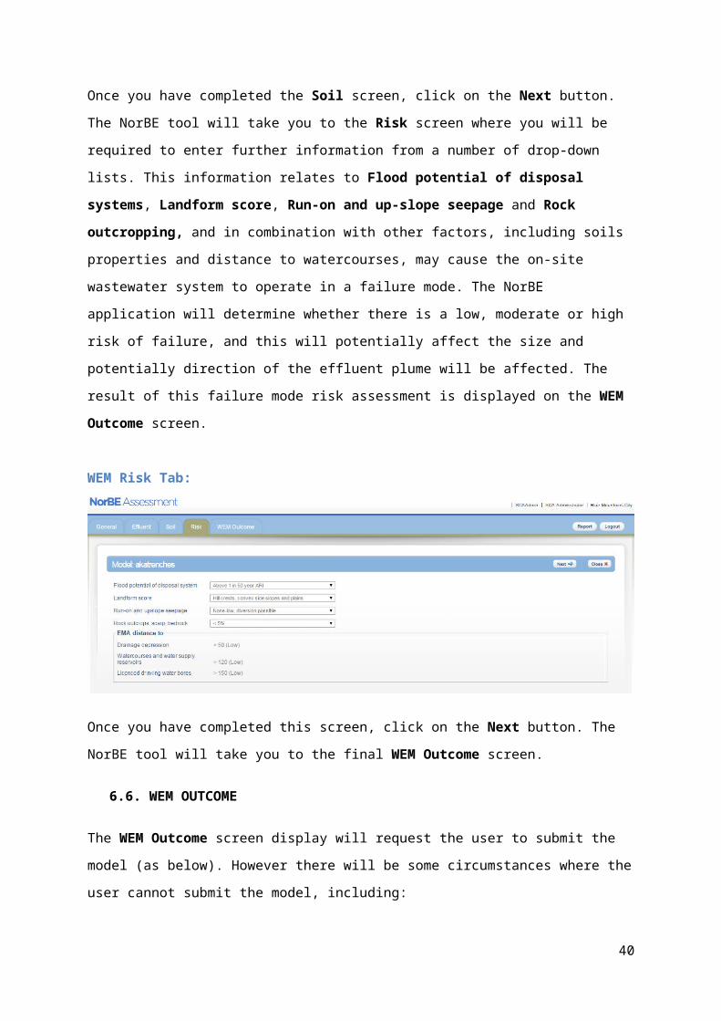
Once you have completed the Soil screen, click on the Next button. The NorBE tool will take
you to the Risk screen where you will be required to enter further information from a number
of drop-down lists. This information relates to Flood potential of disposal systems,
Landform score, Run-on and up-slope seepage and Rock outcropping, and in
combination with other factors, including soils properties and distance to watercourses, may
cause the on-site wastewater system to operate in a failure mode. The NorBE application
will determine whether there is a low, moderate or high risk of failure, and this will potentially
affect the size and potentially direction of the effluent plume will be affected. The result of
this failure mode risk assessment is displayed on the WEM Outcome screen.
WEM Risk Tab:
Once you have completed this screen, click on the Next button. The NorBE tool will take you
to the final WEM Outcome screen.
6.6. WEM OUTCOME
The WEM Outcome screen display will request the user to submit the model (as below).
However there will be some circumstances where the user cannot submit the model,
including:
- the wastewater system is not compatible with various site constraints including soils,
slope, lot size, rainfall, occurrence of severe frost, or intermittent use of the system
and a WEM Outcome of ‘Not Satisfied’ is generated
- where a slope is not compatible with the chosen system. The user can run a model if
they confirm that the site slope is suitable based on a site inspection (a check box is
provided in this case)
31
- where a disposal system requires more detailed design for the soil type. A message
will be provided to remind the user of this requirement
- where the EMA does not meet the minimum or maximum requirements.
In the event that the model runs and a plume greater than 250 m is generated, a message
will be appear stating this fact, and the plume will be displayed to the 250 m maximum. It is
likely that NorBE will not be satisfied.
When the WEM model is submitted, the run will take approximately five minutes, depending
on whether there are other WEMs that may be waiting to run. The WEM Outcome screen
now displays the date and the time the model was submitted to be run.
WEM Model has been submitted:
You will receive an email once the model is run, providing details of the NorBE and WEM
assessment name and number and a link to the assessment. You can then view the WEM
output (the plume). You will also receive an email in the event that a model fails.
PLEASE NOTE:
While the model is running, the NorBE application can still be used to assess other
DAs or to create and run new WEM models.
If you have not already closed the WEM Outcome screen prior to receiving the email
notification, you will need to refresh your screen (press F5) to view the plume.
32
If you do not have your email opened and want to check whether the model has been
completed, you can just refresh the screen or go to the WEM tab (a completed model
will be indicated by a green tick).
The below screenshot shows examples of where the wastewater disposal system limitation
checks have failed:
System not suitable due to lot size, severe frost area and soil depth
System not suitable due to slope (slope override button display) and high rainfall** high rainfall restrictions only relevant for surface irrigation
33
Once model has been run, you will then need to check whether the plume intersects a lot
boundary or comes within relevant buffers to drainage depressions, watercourses,
groundwater bores etc. A series of questions records this information, which will determine
the WEM Outcome and therefore whether NorBE is satisfied for wastewater or not. You will
need to click the Review button after answering these questions, which will generate the
final WEM Outcome and lock the WEM. Before you review the WEM model, make sure you
have visited the site so you can confirm the location of watercourses, drainage depressions
and bores.
The WEM Outcome screen will display the WEM Outcome, risk profile, initial slope,
proposed and minimum area of the EMA, disposal system type, and the date the model was
submitted. The user can also make a copy of the model from this page.
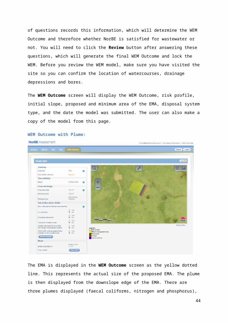
WEM Outcome with Plume:
34

The EMA is displayed in the WEM Outcome screen as the yellow dotted line. This
represents the actual size of the proposed EMA. The plume is then displayed from the
downslope edge of the EMA. There are three plumes displayed (faecal coliforms, nitrogen
and phosphorus), which are translucent and overlayed on top of one another. The legend is
located under the GIS tool display.
If you click on the Report button, you will download a WEM assessment report, in PDF
format in a separate window, which provides all details entered for the model.
6.7. ONSITE WASTEWATER SYSTEM AND DISPOSAL SYSTEM SITE REQUIREMENTS
Consistent with the Standard AS/NZS 1547: 2012, the following limitations are placed on the
use of certain effluent disposal systems.
Table 6.7.1 - General Limitations for Wastewater and Disposal Systems
System/Disposal Method Limitations Implications for designWastewater systemsAWTS Intermittent loads System not suitable
Effluent disposal systemETA Slope > 20% System not suitable
35

Soil depth < 0.75 m System not suitable
Sand Mound Slope > 15% System not suitableAmended Soil Mound Slope > 7% System not suitable
Absorption trenches Slope > 20% Soil depth < 0.75 m
System not suitableSystem not suitable
Absorption beds Slope >20% Soil depth <0.75 m
System not suitableSystem not suitable
Surface Irrigation Lot size < 2000 m2
Slope > 7% Annual Rainfall > 1200 mm Severe Frosts Soil depth <0.25 m
System not suitableSystem not suitableSystem not suitableSystem not suitableSystem not suitable
Sub-surface irrigation Slope > 20% Soil depth <0.25 m
System not suitableSystem not suitable
Please note: where system is not suitable, a message will appear in the WEM to indicate
this and the assessment cannot continue. On such occasions, a suitable design will need to
be negotiated with the proponent, otherwise councils will need to refuse consent on water
quality grounds and a note will need to be added to the NorBE assessment to that affect.
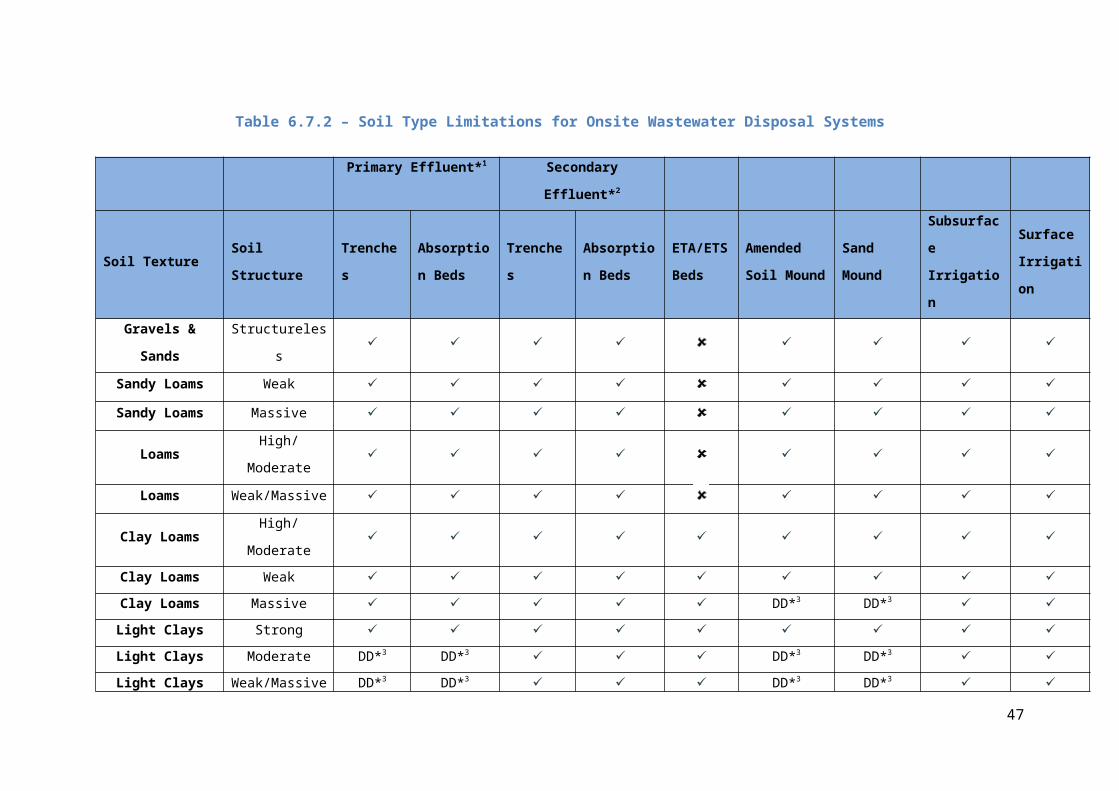
Table 6.7.2 below also lists on-site wastewater disposal system limitations associated with
soil type consistent with AS1547:2012.
36
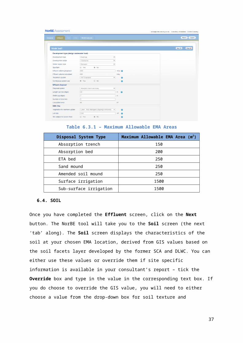
Table 6.7.2 – Soil Type Limitations for Onsite Wastewater Disposal Systems
Primary Effluent*1 Secondary Effluent*2
Soil Texture Soil Structure TrenchesAbsorption Beds
TrenchesAbsorption Beds
ETA/ETS Beds
Amended Soil Mound
Sand Mound
Subsurface Irrigation
Surface Irrigation
Gravels & Sands Structureless ✓ ✓ ✓ ✓ ✓ ✓ ✓ ✓Sandy Loams Weak ✓ ✓ ✓ ✓ ✓ ✓ ✓ ✓Sandy Loams Massive ✓ ✓ ✓ ✓ ✓ ✓ ✓ ✓
Loams High/Moderate ✓ ✓ ✓ ✓ ✓ ✓ ✓ ✓Loams Weak/Massive ✓ ✓ ✓ ✓ ✓ ✓ ✓ ✓
Clay Loams High/Moderate ✓ ✓ ✓ ✓ ✓ ✓ ✓ ✓ ✓Clay Loams Weak ✓ ✓ ✓ ✓ ✓ ✓ ✓ ✓ ✓Clay Loams Massive ✓ ✓ ✓ ✓ ✓ DD*3 DD*3 ✓ ✓Light Clays Strong ✓ ✓ ✓ ✓ ✓ ✓ ✓ ✓ ✓Light Clays Moderate DD*3 DD*3 ✓ ✓ ✓ DD*3 DD*3 ✓ ✓Light Clays Weak/Massive DD*3 DD*3 ✓ ✓ ✓ DD*3 DD*3 ✓ ✓
Med-heavy Clays Strong DD*3 DD*3 DD*3 DD*3 ✓ DD*3 DD*3 ✓ ✓Med-heavy Clays Moderate DD*3 DD*3 DD*3 DD*3 ✓ DD*3 DD*3 ✓ ✓Med-heavy Clays Weak/Massive DD*3 DD*3 DD*3 DD*3 ✓ DD*3 DD*3 ✓ ✓
Notes*1. Septic tank, Dry Composting Toilet, Wet Composting Toilet, Greywater Systems
*2. AWTS, Sand Filter
*3. DD = Detailed design required. Special design criteria need to be applied, including soil modifications and soil permeability testing.
✓ Allowable system
System not preferred and therefore cannot be modelled in the WEM
37
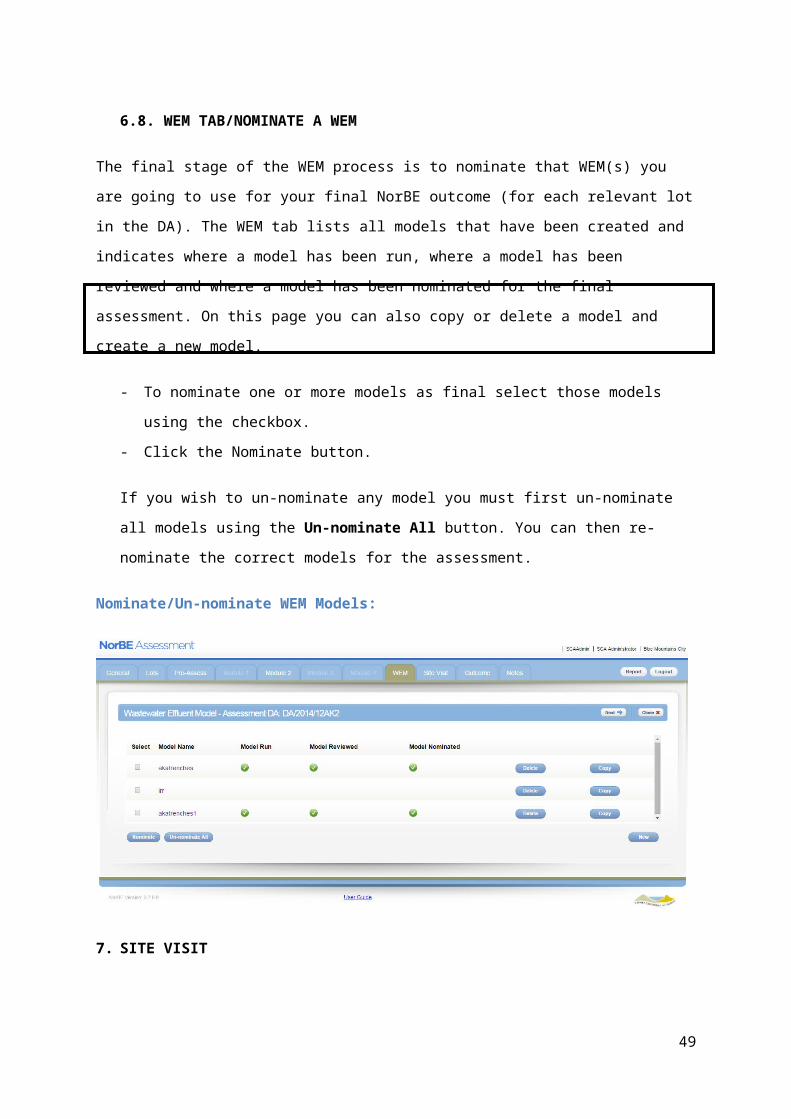
6.8. WEM TAB/NOMINATE A WEM
The final stage of the WEM process is to nominate that WEM(s) you are going to use for
your final NorBE outcome (for each relevant lot in the DA). The WEM tab lists all models that
have been created and indicates where a model has been run, where a model has been
reviewed and where a model has been nominated for the final assessment. On this page
you can also copy or delete a model and create a new model.
- To nominate one or more models as final select those models using the checkbox.
- Click the Nominate button.
If you wish to un-nominate any model you must first un-nominate all models using the
Un-nominate All button. You can then re-nominate the correct models for the
assessment.
Nominate/Un-nominate WEM Models:
7. SITE VISIT
An essential component of the NorBE assessment is to undertake a site visit to confirm the
accuracy of the desk top assessment and to identify any other site specific information and
constraints that may not have been evident in the application. It is mandatory for consultants
to undertake a site visit for all Module 2, Module 3 and Module 4 developments and it is
highly recommended for Module 1 developments.
Prior to visiting the site, it is recommended that you print out a copy of the NorBE
assessment report and, where relevant, a WEM report, which contains screen shot of the
38
relevant WEM model run. All relevant documentation for the DA, including plans and maps
should also be taken on the site visit. The site visit will be required before completing the final
Review of the WEM Model.
One of the last steps of the NorBE assessment will be completing the Site Visit tab by
undertaking the following steps:
- Enter the relevant information, including date of the site visit and the inspector’s
name, both of which are compulsory.
- Confirm that the site visit matches the desk top assessment.
Also confirm whether:
- Lot boundary and infrastructure setback requirements are met.
- Soil in field/Water NSW GIS is consistent with the wastewater report.
Site Visit Screen:
PLEASE NOTE: If any other aspect of the desktop assessment does not match the site visit
observations, then those aspects will need to be re-visited in the NorBE assessment
otherwise the NorBE outcome will be set at ‘Not Satisfied’.
8. ADDING CONDITIONS AND NOTES
The NorBE tool allows you to add in a Master note and Specific notes at any stage of the
assessment until it has been submitted for approval. This can be done by clicking on the
Notes tab along the top right hand side of the Assessment Screen.
How to add a Master note:
A Master note can be added by typing the note in the free text box and then clicking on the
Save button.
39
To Edit or Delete a master note, change or delete the text in the text box and click the Save
button again.
Notes Screen:
Master notes can be viewed from the Assessments Screen by hovering over the speech
bubble next to a DA in the list.
Viewing a Master Note on the Assessments Screen:
How to add a Specific note:
A Specific note can be added by clicking the New button at the bottom right of the page.
Enter the note into the text box that appears and click Save.
40
To Edit a specific note, click on the note to open up the text box, edit the text and click on
the Save button again.
To Delete a specific note, click on the note to open up the text box and then click the Delete
button.
More than one specific note can be added and will appear as a list in this Section.
It should be noted that only the user who created a note can edit or delete it.
The NorBE tool also sets conditions automatically for matters not relating to on-site
wastewater systems, depending on what information is entered into the assessment for the
Module screens. These conditions are listed in the Specific notes Section of the Notes
screen with a green tick next to them. To view the text for a condition, click on the condition.
PLEASE NOTE: Conditions are not automatically set within the WEM tabs due to the
complex nature of the model. Water NSW has conditions for each type of wastewater
system and disposal field that has been provided to councils. These conditions are also
provided (and updated) on the Water NSW’s website.
Both Notes and Conditions will be detailed in the NorBE Assessment Report (see Section
11).
Automatic Conditions:
9. NORBE OUTCOME
Once you have answered all relevant questions and completed a WEM and site visit (where
appropriate) clicking the Next button will take you to the NorBE Outcome tab. The NorBE
41

tool will generate a NorBE outcome based on the information you entered during the
assessment.
NorBE Outcome Tab:
The Outcome tab will show the NorBE status, which will be either Consultant In Progress or Lodged once an assessment has been lodged. The System outcome can either be
‘TBA’ (to be advised), Satisfied, Not Satisfied or SCA concurrence required (now Water
NSW).
Please note: regardless of the System outcome, a Module 3 or 4 assessment must be
referred to Water NSW for concurrence.
Provision is made in the tool for a User outcome to be recorded. Where a user outcome is
different to the system outcome a note must be entered to explain the discrepancy in the
outcome (a text box will appear automatically). The User outcome will override the System outcome in the event that they are different.
User Outcome Override:
42

10. LODGING AN ASSESSMENT
When the assessment is finished and a System outcome (other than TBA) has been
generated, the assessment can be Lodged to Council by clicking the Lodge button. This will
move your assessment to the Lodged screen on the Assessments Page. Once a council
opens your lodged assessment, it will disappear from the Lodged screen and you will no
longer be able to view it.
- To lodge an assessment, click the Lodge button.
- Once an assessment has been lodged it is possible to recall it for further assessment
by clicking the Reassess button on the Outcome screen.
10.1. REASSESS
If the assessment requires reassessment once it has been lodged, and before the council
has assigned a DA number and moved the assessment to their In Progress state, the
consultant can use the Reassess button to send it back to the In Progress state.
10.2. REWORK
It is also possible for a Council user to return a consultant’s lodged assessment. You will
receive an email if this happens and the assessment will appear back in your In Progress
tab with a Council reference number attached to it. A Note will have been attached to the
assessment explaining why it has been returned for further assessment. This can be found
in the Notes tab.
43
11. CREATING REPORTS
11.1. NorBE ASSESSMENT REPORT
When completing a Module 1, Module 2, Module 3 or Module 4 assessment, it is possible at
any stage of the assessment to download an assessment summary by clicking the Report button at the top right of the screen. The report opens in a new window and can be printed
or saved electronically.
This report acts as a summary of everything that is entered into that specific assessment at
the time the report is generated. It will include the details of all WEMs completed as well as
the site inspection questions.
An excerpt from a NorBE assessment summary report is shown below:
NorBE Summary Report:
44

11.2. WEM REPORT
It is possible to download a WEM summary report at any stage during the WEM by clicking
the Report button at the top right of the screen. The report opens in a new window and can
be printed or saved electronically.
This report acts as a summary of all information that is entered into that specific WEM at the
time the report is generated and can be included in the Council Development Application
assessment. The report also includes a map of the WEM Outcome plume and all the
relevant lot(s).
12. HELP
- Contact details
For technical help with the tool please email [email protected]
For general enquiries regarding NorBE assessments for DAs please contact an officer from
Water NSW’s Planning and Assessments team on 02 4724 2400.
45

APPENDIX 1 – ACRONYMS
AEP Annual exceedance probability
DA Development application
DLWC (former) Department of Land and Water Conservation
EMA Effluent management area
GIS Geographical information systems
Ksat Saturated hydraulic conductivity or soil permeability
NorBE Neutral or beneficial effect (on water quality)
Psorp Phosphorus sorption
SCA Sydney Catchment Authority
SEPP State Environmental Planning Policy (Sydney Drinking Water Catchment) 2011
SIX Spatial Information eXchange
SSSQM Small scale stormwater quality model
WCMS Water cycle management study
WEM Wastewater effluent model
46
APPENDIX 2 – DEVELOPMENT CLASSES
Development Class Description Module
Grouping
B Existing dwelling / dual occupancy sewered 1
C New dwelling / dual occupancy sewered 1
DDu
Building/farm building with no on-site wastewater proposalBuilding/farm building with wastewater
12
E Bed and breakfast sewered 1
I Bed and breakfast unsewered 2
Fs Swimming pool / spa pools only, sewered area 1
FU Swimming pool / spa pools only, unsewered area 2
G Existing dwelling / dual occupancy < 8 bedrooms unsewered 2
Gs New dwelling / dual occupancy < 8 bedrooms unsewered 2
GL Existing/new dwelling/dual occupancy ≥ 8 bedrooms unsewered 5
K Greywater systems in unsewered areas only 2
LS1 ≤3 multi-dwelling housing, sewered 1
LS3 ≥4 multi-dwelling housing, sewered 3
LU Multi-dwelling housing, unsewered 5
MS1 Subdivision, sewered <4 lots 1
MS3 Subdivision, sewered ≥4 lots 3
NUS Subdivision, unsewered <4 lots 2
NUL Subdivision, unsewered ≥4 lots 4
ORS Retail premises/office premises, sewered 1
ORU Retail premises/office premises, unsewered 2
OI Industrial 5
P Tourist / recreation / religious / education establishment or facility 5
Q Intensive livestock 5
R Intensive plant growing 5
S Designated development 5
T Other development – eg offensive or hazardous industry or storage establishment development, service stations
5
Us Earthworks / farm dams <2,500 m2 total disturbed area 1
Ul Earthworks / farm dams ≥2,500 m2 total disturbed area 5
VS Car parks <2,500 m2 1
VL Car parks >2,500 m2 5
WS Demolitions <2,500 m2 1
WL Demolitions >2,500 m2 5
Y Sewerage systems that have an intended processing capacity of 5
47

more than 20 persons equivalent capacity or 6 kL per day
Z Other development 5
APPENDIX 3 – SIZING THE EFFLUENT MANAGEMENT AREA
The WEM requires the EMA to be sized consistent with SCA requirements for minimum area, which incorporates methods described in AS/NZS 1547:2012. These requirements have been incorporated into the WEM. The following equations and values are used in the WEM to automatically calculate the minimum area.
Note: The WEM uses the proposed EMA to run the model, not the calculated minimum area. However, where the proposed EMA is smaller than the calculated minimum area, the WEM will not run and a message will be displayed stating that the proposed EMA must be equal to or greater than the minimum area.
For Non-irrigation Systems:
The minimum area is calculated using hydraulic sizing only.
The hydraulic sizing is calculated using the following equation:
where: AD = total minimum effluent management area (m2)Q = daily hydraulic flow from on-site wastewater treatment system (L/d)DLR = design hydraulic loading rate to soil (mm/d or L/m2/d)
DLR is a value that varies primarily with soil type, quality of effluent being applied and the disposal method. Values for DLR are provided in Table A1.
For Irrigation Systems:
The minimum area is calculated using the hydraulic sizing and nutrient sizing (for both nitrogen and phosphorus). The minimum area is taken to be the largest minimum area of the three areas calculated individually for the required hydraulic sizing, nitrogen sizing and phosphorus sizing.
Consistent with the sizing for non-irrigation systems, the hydraulic sizing for irrigation systems is calculated using the following equation:
where: AD = total minimum effluent management area (m2)Q = daily hydraulic flow from the on-site wastewater treatment system (L/d)DLR = design hydraulic loading rate to soil (mm/d or L/m2/d)
48
Values for DLR are provided in Table A1.
The minimum area is also calculated on the basis of an annual nutrient application budget and soil sorption processes.
The nutrient sizing (for both phosphorus and nitrogen) is calculated using the following equation, specifically developed by Daniel Martens as part of the WEM development:
where: AD = total minimum effluent management area (m2)CX = nutrient concentration from on-site wastewater treatment system (mg/L)Q = daily hydraulic flow from onsite wastewater treatment system (L/d)UR = plant nutrient uptake rate (kg/ha/year)d = design soil depth (m)np = soil porosityGS = soil specific gravity (typically 2.65 g/cm3)Xsorption = nutrient sorption with soil (mg/kg)
Values for plant nutrient uptake rate (UR) are provided in Table A2.
Values for nutrient concentration from on-site wastewater treatment system (CX) are provided in Table A3.
Soil porosity (np) can also be calculated as (1- soil bulk density/soil specific gravity)
Note: in the case of nitrogen, Xsorption is assumed to be 0, therefore the equation becomes:
49
Table A1 – Design Loading Rates for Hydraulic Loading Sizing
Primary Effluent Secondary Effluent
Soil Texture Soil Structure TrenchesAbsorption Beds
TrenchesAbsorption Beds
ETA/ETS Beds
Amended Soil Mound
Sand Mound
Subsurface Irrigation
Surface Irrigation
Gravels & Sands Structureless 20 20 50 50 NP 32 32 5 5
Sandy Loams Weak 20 20 50 50 NP 32 32 5 5
Sandy Loams Massive 15 15 50 50 NP 24 24 5 5
Loams High/Moderate 15 15 50 50 NP 24 24 4 4
Loams Weak/Massive 10 10 30 30 NP 16 16 4 4
Clay Loams High/Moderate 10 10 30 30 12 16 16 3.6 3.6
Clay Loams Weak 6 6 20 20 8 8 8 3.6 3.6
Clay Loams Massive 4 4 10 10 5 5 5 3.6 3.6
Light Clays Strong 5 5 12 12 8 8 8 2.9 2.9
Light Clays Moderate 4 4 10 10 5 5 5 2.9 2.9
Light Clays Weak/Massive 4 4 8 8 5 5 5 2.9 2.9
Med-heavy Clays Strong 5 5 10 10 5 6 6 2.1 2.1
Med-heavy Clays Moderate 4 4 8 8 5 5 5 2.1 2.1
Med-heavy Clays Weak/Massive 4 4 8 8 5 5 5 2.1 2.1
50

Table A2 – Plant Nutrient Uptake Rates for Effluent Disposal
Crop Total Nitrogen(kg/ha/year)
Total Phosphorus(kg/ha/year)
Good quality woodland 90 25
Poor quality woodland 65 20
Lawn – fully managed (clippings removed) 240 30
Lawn – unmanaged 120 12
Improved pasture 280 24
Perennial pasture 99 11
Shrubs and some trees – fully managed 150 16
Shrubs and some trees - unmanaged 75 8
Table A3 – On-site Wastewater Treatment System Effluent Quality
Treatment System Total Nitrogen(mg/L)
Total Phosporus(mg/L)
Faecal ColiformsCFU/100ml)
Septic Tank 160 21 1.0E+07
Dry composting toilet 6000 1500 1.0E+05
Wet composting toilet 35 10 5.0E+03
Sand filter – single pass (includes septic tank pre-treatment)
35 10 5.0E+03
Sand filter – recirculating (includes septic tank pre-treatment)
25 10 5.0E+03
Amended soil mound (includes septic tank pre-treatment)
15 1 1.0E+03
AWTS – Standard 30 12 1.0E+02
Sand Mound (includes septic tank pre-treatment)
35 10 5.0E+03
Greywater systems 10 20 5.0E+02
51