introduction to weather - atmospheric sciences
TRANSCRIPT

3
3
INTRODUCTION to
WEATHER

4
4
Section A. Introduction
1. Weather and climate: Weather is the short-term variations of atmosphere. Meteorology is the scientific study of weather. Climate is the long-term averages and extremes of the weather; and climatology is the scientific study of climate.
2. Local weather/climate is determined by latitude, geographical features, altitude, near the ocean or not, vegetation cover, cloud coverage, pressure patterns, prevailing wind, and storm tracks.
3. Climate system: Our earth and atmosphere system includes the atmosphere (air), lithosphere (soil, mountains), hydrosphere (water, oceans), cryosphere (ice, snow), and biosphere (the living).
4. Why do we have the weather and climate on earth?
Because of the solar (short-wave) radiation from the sun, that drives the atmospheric and oceanic motions. The dangerous solar radiation (such as gamma waves, x-rays, and ultraviolet radiation) is absorbed by ionized nitrogen and oxygen in thermosphere and ozone in the stratosphere. Most solar energy concentrates in the visible light range. Once the earth and atmosphere system receives energy (radiation) from the sun, it emits long-wave (infrared, terrestrial) radiation back to the space.
Part of long-wave radiation from the earth's surface is absorbed and re-emitted by the atmospheric greenhouse gases, this counter-radiation helps keep the earth’s surface warm, so that he globally averaged surface temperature is at about 15oC. This warming of the earth's surface by the greenhouse gases is called the (atmospheric) greenhouse effect. The surface temperature over moon and Mars is very cold, because they do not have any air to have the (atmospheric) greenhouse effect. On the other hand, the Venus is very warm, because it has a runaway greenhouse effect due to the thick cloud of carbon dioxide in the atmosphere.
The earth receives short-wave (solar) radiation from the sun during daytime, and the earth emits long-wave radiation day and night. Overall, our earth and atmosphere system maintains a radiation balance over a year. Due to the tilt of the axis of earth's axis (by 23.5o) and the revolution of the earth around the sun, the summer hemisphere is warmer than winter hemisphere, although the earth is farthest away from the sun in July. Furthermore, the tropics receive more short-wave radiation than higher latitudes. In order to reach the global radiational balance, the excess radiational energy has to be transferred from the tropics to the higher latitudes. This energy transfer is accomplished by the atmospheric circulation (i.e., weather) and oceanic circulation.
Four seasons of the earth.

5
5
5. Atmosphere is relatively thin but extremely important, because it (a) contains gases necessary for respiration and photosynthesis; (b) shields living organisms from exposure to hazardous ultraviolet and intense shortwave radiation; and (c) produces (atmospheric) greenhouse effect.
6. Atmosphere is composed of gases (Nitrogen 78.084%, Oxygen 20.947%, Argon 0.934%, Carbon Dioxide 0.033% and other minute gases), suspended solids and liquid particles, and water vapor (up to 4% in volume). 7. Atmospheric pressure always decreases with heigh t due to the decreased number of molecules (i.e., density) with height. However, air temperature changes with height differently. Because of the different characteristics of the temperature change with height, we can identify four layers of the atmosphere: troposphere, stratosphere, mesosphere, and thermosphere.
Vertical pressure change with height. Standardi zed vertical temperature profile.

6
6
Section B. Scales of Motion 1. Time and length scales for atmospheric motions:
Name of Scale Time scale Length Scale Examples
Planetary scale weeks to years 10,000 to 40,000 km Global 3-cell circulation, (Global-scale) ITCZ, Rossby waves, jet stream
Synoptic-scale days to a week 200 to 5,000 km Cyclones, anticyclones, Hurricanes
Mesoscale minutes to a day 2 to 200 km Land/sea breezes, thunderstorms, mountain/valley breezes, (tornadoes)
Microscale seconds to minutes < 2 km Turbulence, evaporation,
convection, vortices
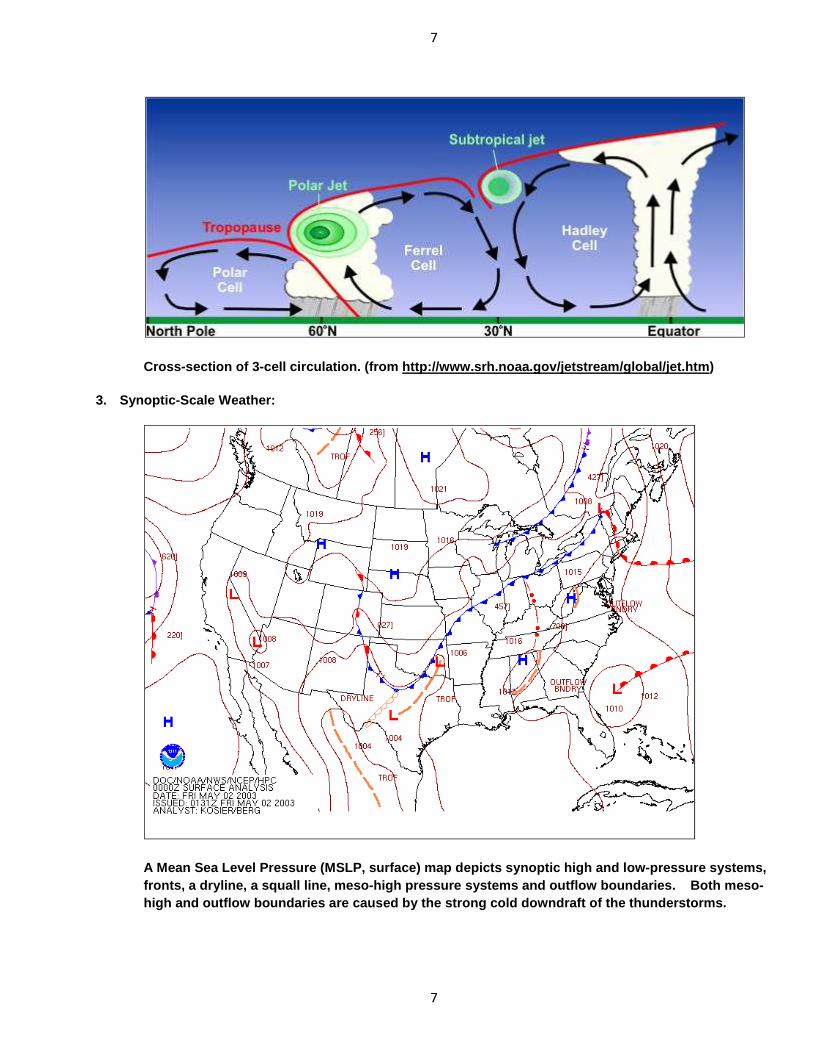
2. Three-cell global circulation model:
Global 3-cell circulation.
7
7
Cross-section of 3-cell circulation. (from http://w ww.srh.noaa.gov/jetstream/global/jet.htm )
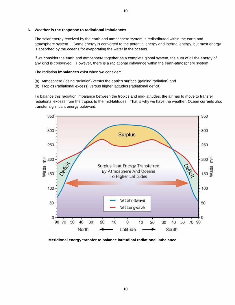
3. Synoptic-Scale Weather:
A Mean Sea Level Pressure (MSLP, surface) map depic ts synoptic high and low-pressure systems, fronts, a dryline, a squall line, meso-high pressur e systems and outflow boundaries. Both meso-high and outflow boundaries are caused by the stron g cold downdraft of the thunderstorms.

8
8
Section C. Radiation
1. Solar shortwave radiation:
The sun provides all the energy the earth needs. The sun emits radiation from short waves to long waves, but most energy is concentrated in the visible wavelengths. Therefore, sometimes the radiation from the sun is called “shortwave radiation”. The shortwave radiation from the sun is subject to processes of reflection, absorption, scattering and refraction within the earth-atmosphere system.
Solar radiation spectrum.
2. Longwave (terrestrial, infrared) radiation:
All the objects within the earth-atmosphere system emit longwave radiation, whose magnitude depends on the absolute temperature of the object. The higher the temperature is, the greater the radiation is (refer to Planck’s law and Stefan-Boltzmann's law). Also the higher the temperature is, the shorter the wavelength of the maximum radiation intensity is (refer to Wien’s displacement law). That is why the radiation from the sun is called shortwave radiation, since the solar surface temperature is about 6,000oC; while the radiation from the earth's surface, clouds, and the atmosphere is called longwave radiation, since their temperatures are much lower compared to the temperature of the sun.
Earth’s radiation spectrum.

9
9
3. (Atmospheric) Greenhouse Effect .
The atmosphere is relatively transparent to the incoming solar (shortwave) radiation. It means that the atmosphere does not absorb too much radiation from the sun except the ozone in the stratosphere. The atmosphere, however, has gases that are absorptive to the longwave radiation. These gases (carbon dioxide, water vapor, oxygen, methane, and ozone) can absorb the longwave radiation from the earth's surface, then re-emit the longwave radiation to all the directions, some of the emission is directed toward back to the earth's surface (it is called backward radiation) to keep the earth's surface warm. This absorption and re-emission of longwave radiation by the greenhouse gases (i.e., CO2, H2O, O3, ..) to keep the earth warm is called the (atmospheric) greenhouse effect .
(Atmospheric) greenhouse effect.
4. Global warming (due to the enhanced greenhouse e ffect): The increased concentration of greenhouse gases (such as carbon dioxide, methane, ozone, and nitrous oxide) in the atmosphere partially contributes to the increase of global surface temperatures.
5. Global radiative equilibrium:
The energy is conserved (balanced) in the global earth-atmosphere system annually.
Earth-atmosphere (shortwave and longwave) radiation budget in w/m 2.
10
10
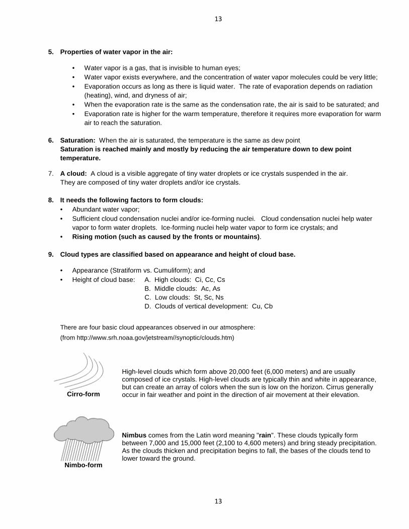
6. Weather is the response to radiational imbalance s.
The solar energy received by the earth and atmosphere system is redistributed within the earth and atmosphere system. Some energy is converted to the potential energy and internal energy, but most energy is absorbed by the oceans for evaporating the water in the oceans.
If we consider the earth and atmosphere together as a complete global system, the sum of all the energy of any kind is conserved. However, there is a radiational imbalance within the earth-atmosphere system.
The radiation imbalances exist when we consider:
(a) Atmosphere (losing radiation) versus the earth's surface (gaining radiation) and (b) Tropics (radiational excess) versus higher latitudes (radiational deficit). To balance this radiation imbalance between the tropics and mid-latitudes, the air has to move to transfer radiational excess from the tropics to the mid-latitudes. That is why we have the weather. Ocean currents also transfer significant energy poleward.
Meridional energy transfer to balance latitudinal r adiational imbalance.

11
11
Section D. Temperature
1. Temperature: Temperature is defined as a measure of translational molecular kinetic energy; or the degree of hotness or coldness as measured on some definite scale by means of any of various types of thermometers.
2. Surface air temperature should be measured inside a ventilated (louvered) instrument shelter (i.e., Stevenson shelter) or a radiation-shielded chamber at 1.5 meters (5 feet) above the grassy ground.
3. Variations of temperature are due to:
• Radiational processes (season, day, cloud cover, surface, ..); • Thermal advection (air mass controls, air movement, …); • Latitude; • Altitude; and • Location (such as city vs. suburb, close to oceans or not, ...).
4. The vertical thermal (temperature) structure of atmosphere: Thermosphere : 80 km and above (ionosphere or exosphere , temperature increases with height) Mesopause Mesosphere : 50 to 80 km (Temperature decreases with height) Stratopause Stratosphere : 15 to 50 km (Ozonosphere , temperature increases with height)
Tropopause Troposphere : Surface to 15 km (Temperature generally decreases with height,
all the weather occurs here .)
Vertical layers and temperature profile of atmosphe re.

12
12
Section E. Moisture
1. Phases of water: gas, liquid and solid. 2. Processes of a phase-change substance:
Sublimation, deposition, condensation, evaporation, freezing, and melting.
3. Latent heat and sensible heat: Latent heat is involved when there is a phase change of a substance, such as water. Water can exist in three different states (i.e., gas, liquid and solid) in the natural environment. The latent heat is released when the water vapor condenses to the water (or sublimes to the ice), and the energy is needed when the water evaporates to the water vapor (or ice sublimes to the water vapor). The freezing of water releases the latent heat, and the melting of ice requires the energy.
On the other hand, sensible heat is a form of energy that can be monitored and sensed. The sensible heat transfer is due to the temperature differences and/or by the wind (namely advection and convection). The air is a poor conductor of heat, so conduction is not effective in transferring sensible heat. The heart is transferred move effectively by advection by the horizontal motion of air and convection by the vertical motion of air. Convection transfers heat from the low-level troposphere to high-level troposphere.
4. Hydrological (water) cycle : It is continuous changes and movements of moisture within the earth- atmosphere system. The most important processes involved in the hydrological cycle are evaporation, transpiration, condensation, precipitation, and runoff.
A hydrological (water) cycle. (from http://www.srh.weather.gov/srh/jetstream/atmos/hydro_cycle.htm)
13
13
5. Properties of water vapor in the air:
• Water vapor is a gas, that is invisible to human eyes; • Water vapor exists everywhere, and the concentration of water vapor molecules could be very little; • Evaporation occurs as long as there is liquid water. The rate of evaporation depends on radiation
(heating), wind, and dryness of air; • When the evaporation rate is the same as the condensation rate, the air is said to be saturated; and • Evaporation rate is higher for the warm temperature, therefore it requires more evaporation for warm
air to reach the saturation.
6. Saturation: When the air is saturated, the temperature is the same as dew point. Saturation is reached mainly and mostly by reducing the air temperature down to dew point temperature.
7. A cloud: A cloud is a visible aggregate of tiny water droplets or ice crystals suspended in the air. They are composed of tiny water droplets and/or ice crystals.
8. It needs the following factors to form clouds:
• Abundant water vapor; • Sufficient cloud condensation nuclei and/or ice-forming nuclei. Cloud condensation nuclei help water
vapor to form water droplets. Ice-forming nuclei help water vapor to form ice crystals; and • Rising motion (such as caused by the fronts or moun tains) .
9. Cloud types are classified based on appearance and height of cloud base.
• Appearance (Stratiform vs. Cumuliform); and • Height of cloud base: A. High clouds: Ci, Cc, Cs B. Middle clouds: Ac, As C. Low clouds: St, Sc, Ns D. Clouds of vertical development: Cu, Cb
There are four basic cloud appearances observed in our atmosphere:
(from http://www.srh.noaa.gov/jetstream//synoptic/clouds.htm)
Cirro-form
High-level clouds which form above 20,000 feet (6,000 meters) and are usually composed of ice crystals. High-level clouds are typically thin and white in appearance, but can create an array of colors when the sun is low on the horizon. Cirrus generally occur in fair weather and point in the direction of air movement at their elevation.
Nimbo-form
Nimbus comes from the Latin word meaning "rain ". These clouds typically form between 7,000 and 15,000 feet (2,100 to 4,600 meters) and bring steady precipitation. As the clouds thicken and precipitation begins to fall, the bases of the clouds tend to lower toward the ground.

14
14
Cumulo-form
Clouds look like white fluffy cotton balls or heaps and show the vertical motion or thermal uplift of air taking place in the atmosphere. The level at which condensation and cloud formation begins is indicated by a flat cloud base, and its height will depend upon the humidity of the rising air. The more humid the air, the lower the cloud base. The tops of these clouds can reach over 60,000 feet (18,000 meters).
Strato-form
"Stratus" is Latin for layer or blanket. The clouds consist of a feature-less low layer that can cover the entire sky like a blanket, bringing generally gray and dull weather. The cloud bases are usually only a few hundred feet above the ground. Over hills and mountains they can reach ground level when they may be called fog. Also, as fog "lifts" off the ground due to daytime heating, the fog forms a layer of low stratus clouds.
Based on the height of cloud base and appearance of a cloud, we define ten (10) basic cloud types:
• High clouds: Ci (cirrus), Cc (cirrocumulus), Cs (cirrostratus)
• Middle clouds: Ac (altocumulus), As (altostratus)
• Low clouds: St (stratus), Sc (stratocumulus), Ns (nimbostratus)
• Clouds of vertical development: Cu (cumulus), Cb (cumulonimbus)
An illustration of 10 (ten) cloud types.

15
15
A. High Clouds
Cirrus (Ci) Cirrocumulus (Cc) Cirrostratus (Cs)
B. Middle Clouds
Altocumulus (Ac) Altostratus (As)
C. Low Clouds
Stratocumulus (Sc) Stratus (St) Nimbostratus (Ns)
D. Clouds of Vertical Development
Fair weather Cumulus (Cu) Cumulus Congestus Cumulonimbus (Cb)

16
16
10. Type of low-level (near or on the ground) cond ensation:
• Fog : It is a cloud at or near the earth's surface; it is a visibility-restricting suspension of tiny water droplets or ice crystals in an air layer next to the earth's surface. The visibility is restricted to 1 km or less by fog; if the visibility is more than 1 km, the suspension is called mist (wet haze). The types of fog include radiation fog (ground fog), advection fog, upslope fog, prefrontal fog, steam fog (sea smoke), ice fog, etc.
• Dew: Water vapor condenses onto grass and other objects near the ground due to the fall of temperature to the dew point, which is > 0oC.
• Frost: It is a deposit of ice on objects generally crystalline in appearance. Frost
is produced by the sublimation (deposition) of water vapor in the air. The water vapor sublimes onto grass and other objects near the ground to form frost due to the rapid fall of temperature to the frost point, which is < 0oC.
o Hoarfrost (White frost): It is a deposit of ice, which generally assumes
the forms of scales, needles, feathers or fans. It forms on objects the surface of which is sufficiently cooled, generally by nocturnal radiation cooling or advection cooling, to bring about the sublimation (deposition) of the water vapor contained in the ambient air.
o Black frost (Freeze): In a very dry weather, the air temperature may become quite cold and drop below freezing point without ever reaching the frost point, and no visible frost forms. It could still cause a significant damage to the plants and crop.
o • White dew: If the temperature falls below freezing after dew has formed, the frozen dew is then
called white dew.
• Rime: It is a deposit of ice generally formed by the freezing of supercooled fog or cloud droplets on objects, the surface temperature of which is below or slightly above 0oC.
(a) Soft rime: Fragile rime consisting mainly of thin needles or scales of ice. (b) Hard rime: Granular rime, usually white, adorned with crystalline branches of grains of ice more or less separated by entrapped air. (c) Clear ice: Smoothed compact rime, usually transparent, fairly amorphous, with a ragged surface, and morphologically resembling glaze.
** Note: Rime is denser and harder than hoar frost, but lighter, softer and less transparent than glaze.
• Glaze: It is a smooth compact deposit of ice, generally transparent, formed by the freezing of supercooled drizzle droplets or raindrops (i.e., freezing rain) on objects the surface temperature of which is below or slightly above 0oC.

17
17
• Ground ice: It is the water from a precipitation of non-supercooled drizzle droplets or raindrops later freezes on the ground. It can also be the snow on the ground freezes again after having completely or partly melted. Snow on the ground can be made compact and hard by traffic to form ground ice.
• (Dry) Haze: It is a suspension in the air of extremely small, dry particles invisible to the naked eye
and sufficiently numerous to give the air an opalescent appearance. It produces a bluish color when viewed against a dark background; a yellowish tint when viewed against a light-colored background. The relative humidity of the haze is generally low.
• Mist (Wet haze): Water vapor condenses on the very small particles and become larger wet
particles but still smaller than those in the fog. All the visible lights are scattered away evenly causing the haze layer to appear white. The visibility in the mist is 1 km or more.
10. Forms of precipitation:
• Drizzle : Small raindrops from 0.2 to 0.5 mm in diameter that drift very slowly toward the ground. • Rain : Raindrop diameters are between 0.5 mm to 5 mm and may approach 5 mm • Freezing rain (freezing drizzle): It forms a coating of ice that sometimes grows thick and heavy.
Air near the surface is sub-freezing (< 0oC).
• Snow : Precipitation composed of white or translucent ice crystals, chiefly in complex branched hexagonal form and often agglomerated into snowflakes.
• Ice pellets (sleet ): Frozen raindrops. Sleet bounces when it strikes the ground and freezing rain does not.
• Hail : Precipitation in the form of irregular lump of ice, always produced by convective clouds, such as cumulonimbus.
• Graupel (snow pellet ): Precipitation consisting of white, opaque, approximately round ice particles having a snow-like structure, and about 2 to 5 mm in diameter.

18
18
11. Winter precipitation types and their environmen ts (from http://www.srh.noaa.gov/jetstream//synoptic/precip.htm)
The vertical distribution of temperature will often determine the type of precipitation (rain vs. snow vs. sleet vs. freezing rain) that occurs at the surface during the wintertime. More often than not, the temperature does not decrease with height but increases, many times by several degrees, before decreasing. This increase, then decrease is called and inversion. In winter, an inversion can be critical in determining the type or types of weather.
In the image (left) the green dashed line is the temperature in respect to elevation. The surface temperature is 25°F (-4°C) and increases with height before decreasing. However, since the temperature remains below freezing any precipitation that falls will remain as snow.
In this image the surface temperature is higher, 27°F (-3°C). Also as elevation increases, the temperature increases to a point where some of the atmosphere is above freezing before the temperature lowers again below freezing. As snow falls into the layer of air where the temperature is above freezing, the snow flakes partially melt. As the precipitation reenters the air that is below freezing, the precipitation will re-freeze into ice pellets that bounce off the ground, commonly called sleet. The most likely place for freezing rain and sleet is to the north of warm fronts. The cause of the wintertime mess is a layer of air above freezing aloft.
Freezing rain will occur if the warm layer in the atmosphere is deep with only a shallow layer of below freezing air at the surface. The precipitation can begin as either rain and/or snow but becomes all rain in the warm layer. The rain falls back into the air that is below freezing but since the depth is shallow, the rain does not have time to freeze into sleet. Upon hitting the ground or objects such as bridges and vehicles, the rain freezes on contact. Some of the most disastrous winter weather storms are due primarily to freezing rain.

Section F. Stability
1. Key concepts:
• Warm air is lighter than cold air at the same pressure. • Moist air is lighter than dry air at the same pressure.
2. How does the temperature and dew point of an air pa rcel change while it ascends or
The rate at which the parcel cools with unsaturated air (air with relative humidity <100%) is is called the dry adiabatic lapse ratetemperature will decrease 5.4°F.
At the same time the dew point of the per kilometer ), therefore the saturation may be reached due to the lifting down to the dew point.
The level at which the air parcel becomes saturated is called thethis level, the air is saturated (moist) and the cooling of the air parcel due to the rising sadiabatic lapse rate ( ~ 6oC per kilometer
The reverse situation will occur when the air parcel lapse rate (10oC per 1 km of sinking), and the dew point will be increasesinking.
3. Expansional cooling (adiabatic cooling) occurs when air parcel ascends. Compressional heating (adiabatic heating) occurs wh en air parcel descends.
4. How to get the air to rise?
• Free convection: Heating near the ground• Forced convection: (1) Orographic lifting;
19
19
m air is lighter than cold air at the same pressure. Moist air is lighter than dry air at the same pressure.
How does the temperature and dew point of an air pa rcel change while it ascends or
The rate at which the parcel cools with increasing elevation is called the "lapse rateunsaturated air (air with relative humidity <100%) is about 10°C per kilometer (i.e., 5.4°F
lapse rate . This means for each 1000 feet increase in elevation, the air temperature will decrease 5.4°F.
At the same time the dew point of the rising air parcel is also decreased at the smaller rate during ), therefore the saturation may be reached due to the lifting when the temperature is cooled
The level at which the air parcel becomes saturated is called the lifting condensation level (LCL)this level, the air is saturated (moist) and the cooling of the air parcel due to the rising s
per kilometer ).
The reverse situation will occur when the air parcel descends , that is, the air parcel will be C per 1 km of sinking), and the dew point will be increased at the rate of 2
Expansional cooling (adiabatic cooling) occurs when air parcel ascends. Compressional heating (adiabatic heating) occurs wh en air parcel descends.
near the ground. Forced convection: (1) Orographic lifting; (2) Frontal lifting; and/or (3) Surface convergence of air.
How does the temperature and dew point of an air pa rcel change while it ascends or descends?
lapse rate ". The lapse rate of 5.4°F per 1000 feet ). This
ncrease in elevation, the air
at the smaller rate during lifting (2oC when the temperature is cooled
lifting condensation level (LCL) . Above this level, the air is saturated (moist) and the cooling of the air parcel due to the rising should follow the moist
, that is, the air parcel will be heated at the dry d at the rate of 2oC per 1 km of
Compressional heating (adiabatic heating) occurs wh en air parcel descends.
(3) Surface convergence of air.

20
20
Section G. Pressure
1. Air pressure: It is the force (weight) per unit area exerted by the air from a specific point up to the top of atmosphere. Air pressure is the same at any point in all directions (i.e., up, down, or sideways).
2. Vertical variation of pressure: Air pressure decreases exponentially with increasing altitude, because of the declining air density, i.e., less weight of air aloft. 99% of atmosphere lies below 32 km (20 miles).
3. Horizontal variation of pressure: All the measured pressure at the surface station is adjusted to the mean sea level to eliminate the effect of altitude. This adjusted pressure is called mean sea level pressure (MSLP).
4. Why the pressure varies horizontally? Air pressure varies due to air density difference, and the air density difference may be caused by temperature difference, moisture difference, or both.
Usually, the cold and dry air masses are accompanied by higher surface pressure than warm and humid air masses. However, the subtropical highs at about 30o latitude are resulted in the descending motion and concentration of mass aloft, even though they are warm and humid.
5. Isobar: The line of equal (constant) pressure on the surface weather map.
6. Pressure gradient: The change of pressure over a (vertical or horizontal) distance.
7. Pressure tendency: The change of pressure with time (usually in the past three (3) hours).
8. A high-pressure system: The pressure at the center is relatively high compared with the pressure of surrounding areas.
9. A low-pressure system: The pressure at the center is relatively low compared with the pressure of
surrounding areas. 10. Ridge: The extended (elongated) area of a high pressure system.
11. Trough: The extended (elongated) area of la low pressure system.
21
21
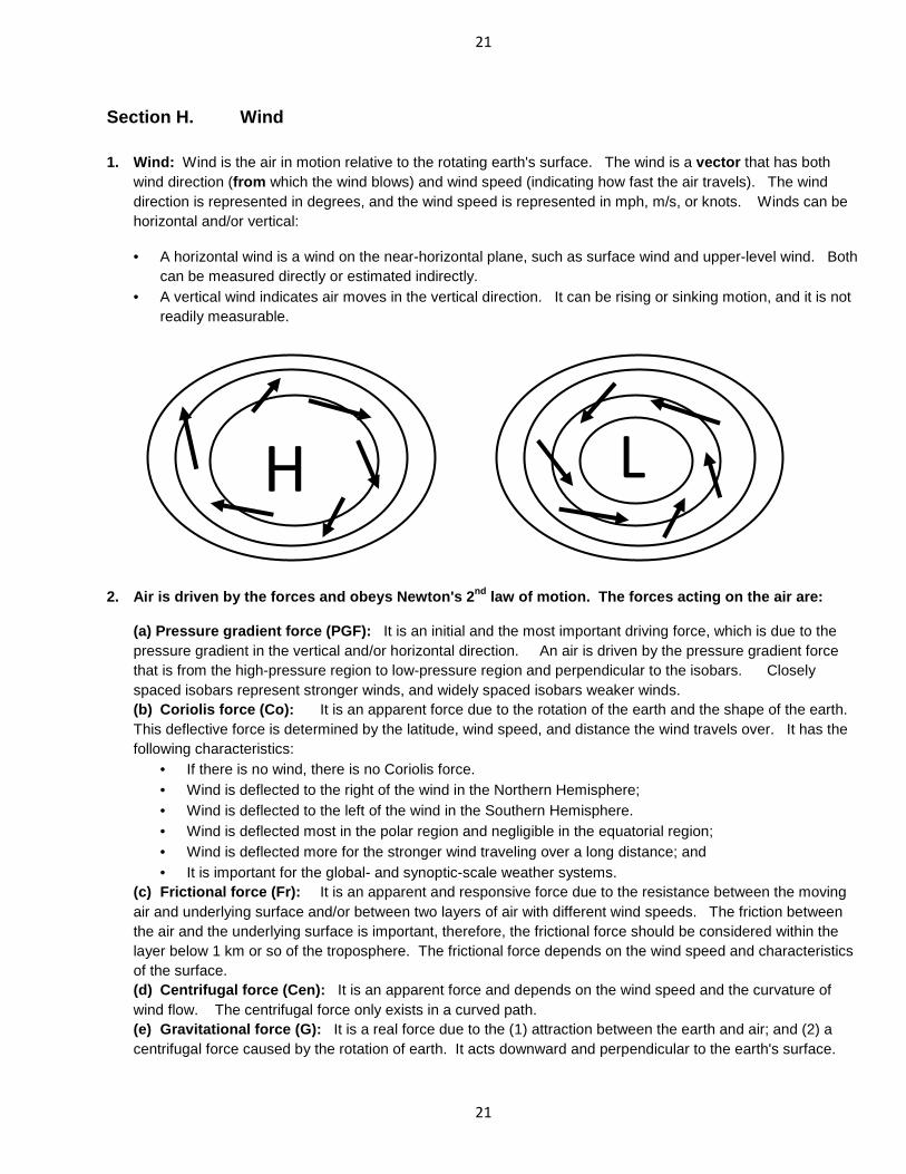
Section H. Wind 1. Wind: Wind is the air in motion relative to the rotating earth's surface. The wind is a vector that has both
wind direction (from which the wind blows) and wind speed (indicating how fast the air travels). The wind direction is represented in degrees, and the wind speed is represented in mph, m/s, or knots. Winds can be horizontal and/or vertical:
• A horizontal wind is a wind on the near-horizontal plane, such as surface wind and upper-level wind. Both can be measured directly or estimated indirectly.
• A vertical wind indicates air moves in the vertical direction. It can be rising or sinking motion, and it is not readily measurable.
2. Air is driven by the forces and obeys Newton's 2nd law of motion. The forces acting on the air are:
(a) Pressure gradient force (PGF): It is an initial and the most important driving force, which is due to the pressure gradient in the vertical and/or horizontal direction. An air is driven by the pressure gradient force that is from the high-pressure region to low-pressure region and perpendicular to the isobars. Closely spaced isobars represent stronger winds, and widely spaced isobars weaker winds. (b) Coriolis force (Co): It is an apparent force due to the rotation of the earth and the shape of the earth. This deflective force is determined by the latitude, wind speed, and distance the wind travels over. It has the following characteristics:
• If there is no wind, there is no Coriolis force. • Wind is deflected to the right of the wind in the Northern Hemisphere; • Wind is deflected to the left of the wind in the Southern Hemisphere. • Wind is deflected most in the polar region and negligible in the equatorial region; • Wind is deflected more for the stronger wind traveling over a long distance; and • It is important for the global- and synoptic-scale weather systems.
(c) Frictional force (Fr): It is an apparent and responsive force due to the resistance between the moving air and underlying surface and/or between two layers of air with different wind speeds. The friction between the air and the underlying surface is important, therefore, the frictional force should be considered within the layer below 1 km or so of the troposphere. The frictional force depends on the wind speed and characteristics of the surface. (d) Centrifugal force (Cen): It is an apparent force and depends on the wind speed and the curvature of wind flow. The centrifugal force only exists in a curved path. (e) Gravitational force (G): It is a real force due to the (1) attraction between the earth and air; and (2) a centrifugal force caused by the rotation of earth. It acts downward and perpendicular to the earth's surface.
H L

22
22
3. The continuous motion of the air occurs within the atmosphere due to the conservation of mass. The surface divergence near a surface high-pressure system is usually associated with the upper-level convergence, and the sinking motion in the middle level completes the circulation.
Similarly, the surface convergence near a surface low-pressure system is usually associated with the upper-level divergence, and the rising motion in the middle level completes the circulation.
An illustration of the vertical structure of a wint er storm. The bottom view depicts the surface features, and the top view shows upper level features of the system.
Sinking air above a surface high and rising air abo ve a surface low. (from http://www.srh.noaa.gov/jetstream//synoptic/wind.htm)

23
23
Section I. Air Mass
1. Air mass: An air mass is an immense body of air, usually 1,600 km or more across, and perhaps several km thick. It is characterized by the homogeneous (i.e., somewhat uniform) physical properties (in particular, temperature and moisture content) at any given altitude.
2. An ideal air mass source region has two essent ial characteristics:
(a) An extensive physically homogeneous surface; and (b) A sufficient stagnation of atmospheric circulation so that the air has time to acquire the temperature and
moisture properties of the underlying surface. Therefore, the major source regions of world air masses are not only homogeneous but are characterized by anticyclonic circulation (high-pressure systems).
3. Notable air mass source regions on the earth: (a) Snow-covered Arctic plains of North America, Europe, and Asia; (b) Subtropical and tropical oceans: (c) Sahara Desert of Africa; and (d) Continental interiors of North America, Europe, and Asia. 4. Bergeron classification of air masses: (a) Based on the source region: Polar (P): Tropical (T): Arctic (A): Arctic/Antarctic region. Tropical (T): Subtropics. Polar (P): High midlatitudes. Equatorial (E): Inner tropics. (b) Based on the moisture: continental (c) and maritime (m).
Global air masses. 5. Air masses that affect US are: In summer: mT, cT, mP, and cP. In winter: mT, cT, mP, cP, and cA.

24
24
Section J. Synoptic-Scale Weather 1. Cyclones (Lows): A cyclone is a low-pressure system whose pressure at the center is lower than that of the
surrounding air. • Warm-core lows: Tropical cyclones (deep in depth), thermal lows (shallow in depth) over the warm
continents. • Cold-core lows: Midlatitude cyclones, cut-off lows, polar lows. They are deep in depth.
2. Anticyclones (Highs): An anticyclone is a high-pressure system whose pressure at the center is greater
than that of the surrounding air. • Warm-core highs: Subtropical highs (such as Bermuda High), deep in depth. • Cold-core highs: Polar highs (i.e., thermal highs) over the cold continents, shallow in depth.
They usually have a polar vortex (a cold-core low) aloft.
3. Ridge and trough: A ridge is an extension of a high-pressure system; and a trough is an extension of a low-pressure system.
4. Front: A front is the transition zone between two distinctive air masses of different densities, which are mainly
determined by temperature and moisture content. There are four types of fronts: stationary front, warm front, cold front, and occluded front. Additionally, there are lines of discontinuity, such as drylines, squall lines, etc.
Types of instability lines.
1 -- Cold Front (in blue) 2 -- Warm Front (in red) 3 -- Stationary Front (in alternative blue and red) 4 -- Occluded Front (in purple) 5 -- Trough ("TROF") (in orange)
Also used to depict Outflow Boundary ("OUTFLOW BNDRY") (in orange) 6 -- Squall Line (in red) 7 -- Dryline (in orange) 8 -- Tropical Wave ("TRPCL WAVE") (in orange)

25
25
5. Norwegian Cyclone Model (from http://www.srh.noaa.gov/jetstream//synoptic/cyclone.htm) The Norwegian cyclone model, so named to honor the Norwegian meteorologists who first conceptualized the typical life cycle of cyclones in the 1910s and 1920s, presents the evolution of a cyclone . In this model, there will initially be a boundary, or front, separating warm air to the south from cold air to the north. The front is often stationary. (Left - Overhead view; Right - 3D view)
A wave on the front will form as an upper level disturbance embedded in the jet stream moves over the front. The front develops a "kink" where the wave is developing. Precipitation will begin to develop with the heaviest occurrence along the front (dark green).
As the wave intensifies, both cold and warm fronts become better organized.

26
26
The wave becomes a mature low pressure system, while the cold front, moving faster than the warm front, "catches up" with the warm front. As the cold front overtakes the warm front, an occluded front forms.
As the cold front continues advancing on the warm front, the occlusion increases and eventually cuts off the supply of warm moist air, causing the low pressure system to gradually dissipate.

27
27
Section K. Upper Air Flow
1. Upper air westerlies:
• Long waves (Rossby waves): Their wavelengths are more than 4,500 km or so, and they have zonal or meridional flow patterns.
• Short waves: Their wavelengths are less than 1,000 km or so. • Baroclinic waves: Most upper-level waves in the midlatitudes are baroclinic. • Blocking systems: They include cut-off lows and blocking (i.e., cut-off) highs. • Jet stream: A relatively narrow core of very strong westerly wind. The latitudinal temperature
contrast is responsible for the existence of the polar jet stream.
2. Jet stream:
A jet stream is a core (e.g., tunnel) of fast moving wind in the upper levels of the atmosphere just below the tropopause. Jet streams vary in height and can reach speeds of 275 mph. The winds blows from west to east in jet streams but the flow often shifts to the north and south. Jet streams follow the boundaries between hot and cold air. Since these hot and cold air boundaries are most pronounced in winter, jet streams are the strongest for both the northern and southern hemisphere winters.
The actual appearance of jet streams result from the complex interaction between many variables - such as the location of high and low pressure systems, warm and cold air, and seasonal changes. They meander around the globe, dipping and rising in altitude/latitude, splitting at times and forming eddies, and even disappearing altogether to appear somewhere else.
Jet streams also "follow the sun" in that as the sun's elevation increases each day in the spring, the jet streams shifts north moving into Canada by Summer. As Autumn approaches and the sun's elevation decreases, the jet stream moves south into the United States helping to bring cooler air to the country.
Artist's illustration of Jet stream. (from http://www.srh.noaa.gov/jetstream//global/jet.htm)

28
28
3. Types of jet stream:
• Subtropical jet stream: It is below the tropopause at around 20 to 30o latitudes, and it is relatively constant in position in a given season.
• Polar jet stream: It is just below the tropopause in the midlatitudes of 50-60o latitudes, and it varies in intensity and position from day to day. It is produced by the latitudinal temperature contrast, and it is closely related to the polar front and extratropical cyclones (low-pressure systems).
• Polar night jet stream: It occurs in the stratosphere in the high latitudes during the winter season.
Polar jet and subtropical jet. (from http://www.srh.noaa.gov/jetstream//global/jet.htm)
300 mb map at 12 UTC, 3/9/2010 depicting jet streams (from http://www.rap.ucar.edu/weather/upper/).
29
29
Section L. Hurricanes
1. What is the tropical cyclone?
It is a cyclone (i.e., low-pressure system) that develops over warm tropical waters, it can usually produce strong winds (in excess of 33 m/s, 65 knots, or 39 mph).
2. Why does the tropical cyclone form?
In order to reach a global radiational energy balance , the energy excess in the tropics has to be transferred to middle and high latitudes. Both atmospheric circulation (such as Hadley cell circulation, and high and low pressure systems) and oceanic circulation (such as surface ocean currents) transport energy from tropics to middle and high latitudes. Additional latitudinal energy transport is carried out by tropical cyclones, which process lots of energy and moisture, and they tend to move from low latitudes to high latitudes.
3. How does the tropical cyclone form?
• It usually starts as a slight disturbance in the easterly flow of the trade winds in the tropics. • It also requires warm sea surface temperatures of at least 27oC or 80oF. • It needs a strong low-level convergence to produce the vertical motion. The release of latent heat
energy as water vapor condenses fuels the development of the storm. • Upper level divergence assists in the pressure fall in the vertical column of the storm.
4. Where does the tropical cyclone form?
• The tropical cyclone generally forms within 5-20o (N or S) latitude over warm bodies of water and is steered by upper-level winds.
• Tropical cyclones do not occur over South Atlantic Ocean and Southeastern Pacific Ocean. • Strong tropical cyclones (i.e., the surface sustained wind speeds are greater than 74 mph)
are known by many local names: • Hurricanes in N. Atlantic, Gulf of Mexico, Caribbean Sea and eastern N. Pacific; • Typhoons in western N. Pacific and S. Pacific; • Cyclones in Indian Ocean; • Willy-Willys in Australia. • After initial development, the tropical cyclone may move away from warm tropical waters
onto land or into extratropical latitudes. • The tropical cyclone weakens rapidly after they move inland or over cold waters.
30
30
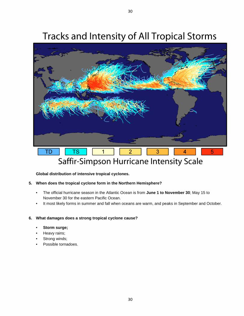
Global distribution of intensive tropical cyclones.
5. When does the tropical cyclone form in the North ern Hemisphere?
• The official hurricane season in the Atlantic Ocean is from June 1 to November 30 ; May 15 to November 30 for the eastern Pacific Ocean.
• It most likely forms in summer and fall when oceans are warm, and peaks in September and October.
6. What damages does a strong tropical cyclone caus e?
• Storm surge; • Heavy rains; • Strong winds; • Possible tornadoes.
31
31
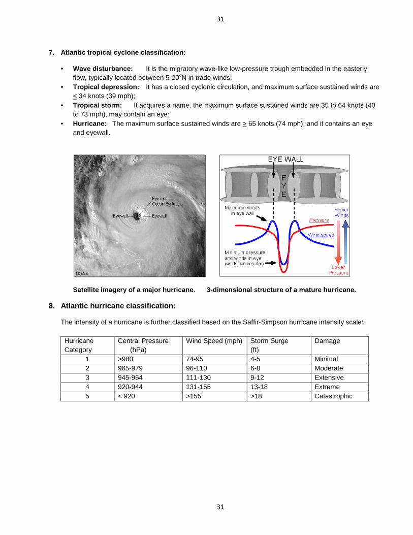
7. Atlantic tropical cyclone classification:
• Wave disturbance: It is the migratory wave-like low-pressure trough embedded in the easterly flow, typically located between 5-20oN in trade winds;
• Tropical depression: It has a closed cyclonic circulation, and maximum surface sustained winds are < 34 knots (39 mph);
• Tropical storm: It acquires a name, the maximum surface sustained winds are 35 to 64 knots (40 to 73 mph), may contain an eye;
• Hurricane: The maximum surface sustained winds are > 65 knots (74 mph), and it contains an eye and eyewall.
Satellite imagery of a major hurricane. 3-dimensi onal structure of a mature hurricane.
8. Atlantic hurricane classification:
The intensity of a hurricane is further classified based on the Saffir-Simpson hurricane intensity scale:
Hurricane Category
Central Pressure (hPa)
Wind Speed (mph) Storm Surge (ft)
Damage
1 >980 74-95 4-5 Minimal 2 965-979 96-110 6-8 Moderate 3 945-964 111-130 9-12 Extensive 4 920-944 131-155 13-18 Extreme 5 < 920 >155 >18 Catastrophic

32
32
9. What factors are responsible for hurricane form ation/intensification?
• Warm sea surface temperatures (i.e., SST > 27oC (80oF)): • Existence of the Coriolis force (i.e., outside the 5oS and 5oN latitude belt); • Low values of vertical shear in horizontal wind in lower atmosphere (i.e., < 15 knots in 1000 - 600 mb
layer); • Major changes in global circulation patterns may affect hurricane formation, such as El Nino, etc.
10. Why does a hurricane dissipate?
• Its energy source (i.e., moisture) is cut off when it makes a landfall; • Its boundary structure is destroyed due the increased surface friction when it makes a landfall; and/or • It moves over the cold water surface (i.e., northern ocean basin), so the energy and moisture transports
from the ocean is significantly reduced.
Atlantic Tropical Cyclone Names
2010 2011 2012 2013 2014 2015 Alex
Bonnie Colin
Danielle Earl
Fiona Gaston Hermine
Igor Julia Karl Lisa
Matthew Nicole Otto
Paula Richard Shary Tomas Virginie Walter
Arlene Bret
Cindy Don
Emily Franklin
Gert Harvey Irene Jose Katia Lee
Maria Nate
Ophelia Philippe
Rina Sean
Tammy Vince
Whitney
Alberto Beryl Chris Debby Ernesto Florence Gordon Helene Isaac Joyce Kirk
Leslie Michael Nadine Oscar Patty
Rafael Sandy Tony
Valerie William
Andrea Barry
Chantal Dorian
Erin Fernand Gabrielle Humberto
Ingrid Jerry Karen
Lorenzo Melissa Nestor Olga Pablo
Rebekah Sebastien
Tanya Van
Wendy
Arthur Bertha
Cristobal Dolly
Edouard Fay
Gonzalo Hanna Isaias
Josephine Kyle
Laura Marco Nana Omar
Paulette Rene Sally
Teddy Vicky
Wilfred
Ana Bill
Claudette Danny Erika Fred
Grace Henri Ida
Joaquin Kate Larry Mindy
Nicholas Odette Peter Rose Sam
Teresa Victor
Wanda
33
33
11. Tropical cyclone alerts in United States as iss ued by the National Hurricane Center (NHC) of Tropical Prediction Center (TPC) of NCEP (National Centers for Environmental Protection):
• Hurricane Advisory: Hurricane advisory is issued every 6 hours describing the storm, its position, anticipated movement, and prospective threat.
• Hurricane Watch: Hurricane watch is the first alert when a hurricane poses a possible, but as yet uncertain threat to a certain coastal area, or when a tropical storm threatens the watch area and has a 50-50 chance of intensifying into a hurricane.
• Hurricane Warning: Hurricane warning warns that within 24 hours or less, a specified coastal area may be subject to:
� Sustained winds of 33 m/s (65 knots) or higher; and/or � Dangerously high water and exceptionally high waves, even though winds may be expected to
be less than hurricanes.
12. What should you do when alerts are given out?
When a hurricane watch is issued for you region, you should be prepared by doing the following:
• Know the elevation of your property above mean sea level so you can relate high water forecasts to your area. Learn the high water (i.e., storm surge) history for your area.
• Have a safe evacuation route planned. • Keep flashlights, portable radio, emergency cooking facilities and extra medical supplies stocked. • Have plans for securing valuables, livestock, and pets. • Know how to reach emergency services (e.g., Red Cross). • Keep your car fueled.
In case of a hurricane warning:
• Leave low-lying areas immediately. • Moor small boats securely if possible, and leave. • Board, shutter or tape windows; brace doors. • Secure objects that may fly about in the wind. • Leave mobile homes for more substantial shelter. • Stay indoors away from doors and windows, unless asked to evacuate. • Listen for weather bulletins. If you are asked to evacuate. GO! It means your life is in danger. • Hurricanes also spawn tornadoes while they are making a landfall, so as a hurricane approaches
you should listen for tornado watches and warnings and be ready to take immediate shelter.