introduction to levelling
TRANSCRIPT

Introduction to Levelling
Prof.Prafulla Kumar Panda
Department of Civil Engg.
9438269572
Email:[email protected]

Structure of talk
• Objective of levelling
• Usages of levelling
• Bench mark, Datum, RL,MSL etc.
• Reading points on levelling
• Levelling instruments
• Types of levelling
• Methods for calculation of reduced level & booking
• Precision in levelling
• Source of errors in levelling

OBJECTIVE
• The aim of levelling is to determine the relative heights of different objects on or below the surface of the earth and to determine the undulation of the ground surface.

USES OF LEVELLING
• To prepare a contour map for fixing sites for reservoirs, dams & etc.
• To determine the altitude of different important points on a hill or to know the reduced levels of different points on or below earth surface.
• To prepare longitudinal section and cross sections of a project to determine volume of earth work.
• To prepare layout map.

DEFINITIONS • Levelling – the art of determining the relative
heights of different points on or below the surface of the earth.
• Datum – a standard position or level that measurements are taken from.
• Reduced level (RL) – vertical distance of a point above or below datum line. May be (+/-).

Cont...
• Benchmark (BM):
– An object whose elevation above mean sea level is known or assumed to be known.
– A bench mark must be an object that is dimensionally stable because it is the reference point for all of the elevations for a survey
– If the bench mark elevation is accidentally changed, all surveys that used it must be redone

Cont... – The object selected should:
• be reasonably permanent for as long as it will be needed, and not easily moved or otherwise destroyed; and
• be capable of being described in such a way that it can be easily relocated.
– A typical local bench mark might be an “X” chipped in a concrete curb or a bridge abutment, an iron pin driven firmly into the ground, or the rim of an electrical or sewer access hole.

Cont... – Types of benchmarks
• GTS
• Permanent
• Temporary
• Arbitrary
• Backside reading (BC)
– The first staff reading taken in any set up of the instrument after levelling has been perfectly done.
– Always taken on a point of known RL.

Cont...
• Foresight reading (FS):
– The last staff reading in any set up of the instrument.
• Intermediate sight reading (IS):
– Any other staff reading between BS and FS in the same set up of the instrument.
• Change point (CP):
– Indicate the shifting of the instrument.
– FS is taken from one setting and BS from the next setting.

Cont...
• Turning point:
– A temporary bench mark that is used to extend the survey a greater distance.
– Usually used wherever the starting station and ending station can not be seen from one instrument position.

Reading points in levelling
BS
Benchmark A
IS IS
FS BS
IS FS
level level
B C D E
Change point
HI HI

LEVELLING EQUIPMENTS
Level
Levelling
rod / staff Tripod

• The Automatic Level is an easy to use surveying Instrument
• Instrument needs only to be setup level within its circular level bubble
• Has a damping compensator which adjsuts line of colimation
• Generally accurate to +/- 2mm
Automatic Level
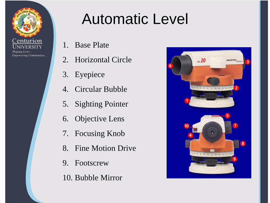
Automatic Level
1. Base Plate
2. Horizontal Circle
3. Eyepiece
4. Circular Bubble
5. Sighting Pointer
6. Objective Lens
7. Focusing Knob
8. Fine Motion Drive
9. Footscrew
10. Bubble Mirror

• Has a compensator similar to Automatic Level
• Radiates a Laser Beam 360 through line of collimation
• Laser is then picked by a receiver to indicate line of collimation
• Some lasers are self leveling
• Survey quality laser levels are designed with two features:
Visible or non-visible
Rotating or non-rotating
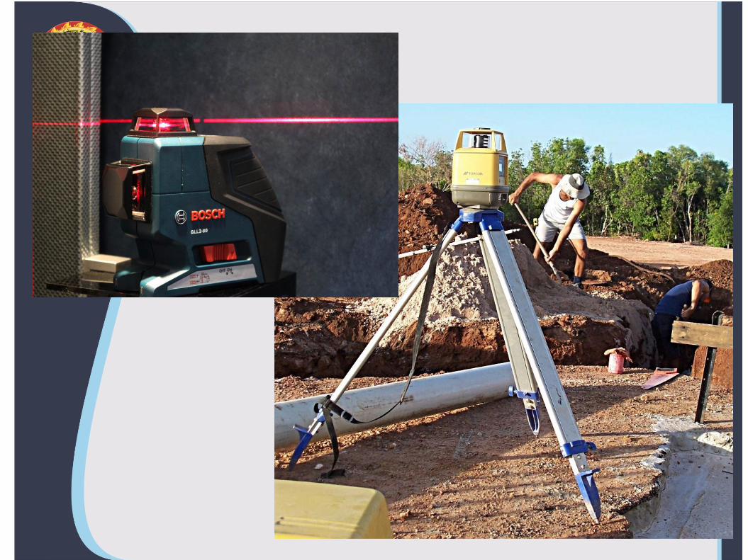
Laser Level

SETTING UP THE EQUIPMENT
1. Set up the tripod.
2. Attached the level to tripod.
3. Adjust the levelling head
4. Adjust the eye piece to sharp focus.
5. Record the staff reading.

Adjusting the levelling head

Focus view

Cont...

Cont...

Staff reading

Wrong way of holding staff

Correct way of holding staff

TYPES OF LEVELLING OPERATION
• Simple levelling:
– When the different of level between 2 points is determine by setting the instrument midway between the points.
A level B
Cont…
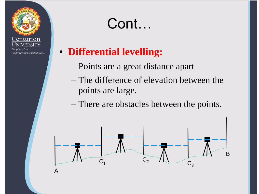
• Differential levelling:
– Points are a great distance apart
– The difference of elevation between the points are large.
– There are obstacles between the points.
A
C1 C2 C3
B

Cont…
• Fly levelling:
– When differential levelling is done in order to connect a benchmark to the starting point of the alignment of any project.
– Only BS & FS readings are taken at every set up.
– No distance are measured.
A
BM
B
C
D L1
L2
L3
L4
CP
CP CP
CP = change point
L1, L2… = position of level

Cont… • Profile levelling:
– Taking levels along a centre line of any alignment (road, railways…).
– BS, IS & FS readings are taken at regular intervals.
BS
Benchmark A
IS IS
FS BS
IS FS
level level
B C D E
Change point
HI HI

Cont… • Check levelling:
– Fly levelling done at end of days work to connect the finishing point with the starting point.
– To check accuracy of work.
Starting point
Finishing point
A
B C
D E
L
L L L
L
CP CP CP
CP
Profile levelling
Check levelling

METHODS FOR CALCULATION OF REDUCED LEVEL & BOOKING
• 2 systems of calculating reduced level
– Height of collimation system.
– Rise and fall system

Height of collimation method
• Also known as height of instrument.
• RLs of unknown points are to be determine by deducting the staff readings from RL of the height of instrument.
EXAMPLE
1
2
3
4
5
6
7
8
9
A
B
C
0.756 m
RL
20.00 m
1.321
1.782
1.671
1.231
1.012
-2.045 0.991
1.125 1.321
1.524
RL
19.617 Bridge

Recording field notes Staff BS IS FS HI RL Remarks
A 0.756 20.756 20.00 HI = RL + BS
1.321 19.435 RL = HI –
IS/FS
1.782 18.974
B 1.231 1.671 20.316 19.085 HI = RL + BS
1.012 19.304
-2.045 22.361
C 1.125 0.991 20.450 19.325
1.321 19.129
1.524 18.926
TOTA
L 3.112 4.186
(+)
(-)
(-) (-)
Arithmetical check: BS - FS = 3.112 – 4.186 = -1.074
: Last RL – 1st RL = 18.926 – 20.000 = -1.074

Rise & fall method
• The difference of level between 2 consecutive points is determined by comparing each forward staff reading with the staff reading at intermediate preceding point.
– Forward staff reading < immediate preceding staff = rise
– Forward staff reading > immediate preceding staff = fall
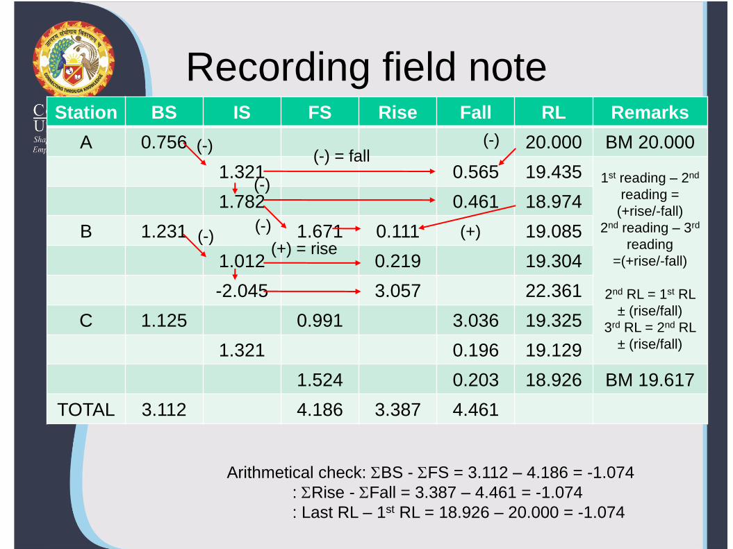
Recording field note Station BS IS FS Rise Fall RL Remarks
A 0.756 20.000 BM 20.000
1.321 0.565 19.435 1st reading – 2nd
reading =
(+rise/-fall)
2nd reading – 3rd
reading
=(+rise/-fall)
2nd RL = 1st RL
± (rise/fall)
3rd RL = 2nd RL
± (rise/fall)
1.782 0.461 18.974
B 1.231 1.671 0.111 19.085
1.012 0.219 19.304
-2.045 3.057 22.361
C 1.125 0.991 3.036 19.325
1.321 0.196 19.129
1.524 0.203 18.926 BM 19.617
TOTAL 3.112 4.186 3.387 4.461
Arithmetical check: BS - FS = 3.112 – 4.186 = -1.074
: Rise - Fall = 3.387 – 4.461 = -1.074
: Last RL – 1st RL = 18.926 – 20.000 = -1.074
(-) (-) = fall
(+) = rise (-)
(-)
(+)
(-)
(-)

Comparison of the 2 systems
Collimation system
Rapid & involve few calculation
No check on RL of intermediate points
Errors in intermediate RL cannot be detected
2 checks on the accuracy of RL calculation
Suitable for longitudinal levelling where there are a number of intermediate sights
Rise & fall system
Laborious & involve several calculations
There is a check on the RL of intermediate points
Errors in intermediate RLs can be detected as all the points are correlated
There are 3 checks on the accuracy of RL calculation
Suitable for fly levelling where there are no intermediate sights

Profile levelling
• Provide accurate topographical information along the proposed routes.
• Yields elevations at definite points along a reference line.

Profile levelling

Profile levelling - plot E
levation
Stations 0 1 2 3 4 5 6 7 8 9 10

PRECISION • Precision in leveling is increased by
– Repeating measurement,
– Making frequenties to established bench marks,
– Using high quality equipment,
– Keeping it in good adjustment, and
– Performing the measurements carefully
• On a simple construction survey, an allowable misclosure of C=0.02ft√n might be used, where n is the number of setups

Cont...
• Recommended the following formula to compute allowable misclosures:-
C = 0.0012 x √K or C = ±5 x √n
C = allowable loop or section
misclosure (mm)
m = constant
K = total length leveled (km)
n = number of level setup

SOURCE OF ERROR
• Instrumental error
• Natural error
• Personal error

Instrumental errors
• Line of sight
• Cross hair not exactly horizontal
• Rod not correct length
• Tripod legs loose

Natural errors
• Curvature of the earth
• Refraction
• Temperature variations
• Wind
• Settlement of the instrument
• Settlement of a turning point

Personal errors
• Bubble not centered
• Parallax
• Faulty rod readings
• Rod handling
• Target setting

PERMISSIBLE ERROR IN LEVELLING
• Precision of levelling is ascertain according to the error of closure.
• Permissible closing error is expressed as
E= closing error in metres
C = constant
D = distance in kilometres
DCE

Cont..
• Permissible errors for different types of levelling:
– Rough levelling
– Ordinary levelling
– Accurate levelling
– Precise levelling
DE 100.0
DE 025.0
DE 012.0
DE 006.0

MISTAKES
• Improper use of a long rod
• Holding the rod in different places for the plus and minus sights on a turning point
• Reading a foot too high
• Waving a flat bottom rod while holding on a flat surface
• Recording notes
• Touching tripod or instrument during reading process.

REDUCING ERRORS & ELIMINATING MISTAKES
• Checking the bubble before and after each reading
• Using a rod level
• Keeping the horizontal length of plus and minus sights equal
• Running lines forward and backward
• Making the usual field book arithmetic checks
