introduction to gis crp 514 – (101)
TRANSCRIPT
1
CITY & REGIONAL PLANNING DEPARTMENT
Introduction to GIS CRP 514 – (101)
Term Paper on Tracking the morphological change of a river extent
of Bangladesh using satellite images in ArcGIS
Submitted to Dr. Baqer Al-Ramadan
Submitted by Imran Reza
Student ID: 201003280
January 23, 2011

2
ABSTRACT
River shapes surrounding landscapes by continuous change in hydrodynamic and
subsequent morpho-dynamic processes. The part of the course of River Padma and
the Lower Meghna drained through the central part of Bangladesh has been taken as
the study area. In Chandpur the lower course of Meghna flows on a very gently
sloping area with low elevation which reduces rather stops the process of valley
incision (deepening) but lateral erosion process and valley widening continues. Such
processes develop wide floodplain over which the river Meghna gradually and
continuously changes its course that reshaped channel morphology and developed
several landforms. In this paper, an attempt has been made to consider such shifts and
to evaluate the micro level morphological changes that have taken place in last several
years. The changes have also been quantified and analyzed by the application of
different tools of GIS software. This study estimates the severity of the river shifting
process of this region and subsequent micro level morphological changes, which may
help in the holistic management plan to protect the river including the cultural
landscapes.

3
Table of Contents
Chapter 1 Introduction
1.1 General 4
1.2 Background of the study 5
1.3 The Padma and Lower Meghna River 6
1.4 Objectives of the study 9
Chapter 2 Literature Review
2.1 General 9
2.2 Channel Pattern 9
2.3 Factors influencing River geometry 12
2.4 Aggradations and Degradation of Channel 13
2.5 Selection of study area 14
2.6 Environmental condition of study area 14
2.6.1 Precipitation 15
2.6.2 Wind 15
2.6.3 Waves 16
2.6.4 Sediment transport processes 17
2.7 Hydro morphological studies of the rivers of Bangladesh 18
2.7.1 Hydro-morphological studies carried out in 18
Meghna River and Meghna Estuary
2.7.2 Hydro-morphological studies in the 20
river around the world
Chapter 3 Theory and Methodology 3.1 General 21
3.2 Data Collection 21
3.3 Methodology 22
Chapter 4 Results and Discussion 4.1 Results Discussion 25
Chapter 5 Conclusion 27
References 28

4
CHAPTER 1
Introduction 1.1 General A close relationship always exists between man and rivers since the beginning of
civilization, because water has always been an integral part of man’s development.
Most of the early civilizations were survived as well as developed near the river
valleys. The most ancient commercial places have been developed along river banks.
Bangladesh is a riverine country with hundreds of rivers overlaying its landscape.
Because of its inherent alluvium nature, the rivers of Bangladesh are morphologically
dynamic characterized by erosion and sedimentation, which results in changes in
hydraulic geometry; plan form and longitudinal profile of the rivers (Habibullah,
1987). Aggradations, degradation or change in plan forms; change in river bed and
meandering characteristics are most common features in the rivers of Bangladesh,
affecting the major rivers as well as the medium and the minor rivers. When bank
erosion of a river takes place the drainage capacity of the river and navigation is
hampered and consequently a large number of populations are directly or indirectly
affected. Erosion could be mitigated through local protective measures for the time
being but properly designed river control and training structures are required to reduce
the loss of lands. A detailed study of hydraulic geo morphology can help controlling
rivers in an effective manner.
This study demonstrates how GIS can be used for describing spatial and temporal
trends of physical river data, including geomorphic trends and features associated
with the local environmental condition of the study area. This study will aid in
understanding physical changes in channel form that are linked to essential habitat
features. Geomorphic trends are assessed through an examination of spatial physical
data in ArcMAP (v 9.3, a GIS application).
Coastal Zone accounts for about 23% of the land area of Bangladesh. Per capita land
availability is very low (Singh, 2000). Above this substantial amount of land is lost
due to erosion in coastal region. Although land is also accreted in some other
locations that land does not become useful and productive immediately. Inhabitants

5
living in areas subjected to erosion become landless. Their sufferings can be
minimized by identifying eroded zone and land accretion opportunities. Being a small
country, Bangladesh needs to extend land areas which can be done only by accretion
in coastal region. Therefore, the GIS technology to this fatal problem can be
effectively used to find out the land eroded or accreted along the river Bank.
1.2 Background of the Study
The Padma-Meghna estuary is a very dynamic estuarine system. Meghna Estuary
extends from Chandpur to the northern end of the Bay of Bengal which is a coastal
plain estuary on the coast of Bangladesh. The coast of Bangladesh is exposed to
extreme meteorological and hydrological conditions. Occasional cyclone surges in
combination with high tides always have devastating effects on the southern part of
Bangladesh, causing loss of human life, crops and livestock as well as the destruction
of property (MES, 2001). The lower Meghna River drains the flow from Ganges
Valley and the southern part of the Himalayas (Ganges River), the Tibet and the
north-eastern part of India (Brahmaputra River) and the north-eastern part of
Bangladesh (Lasarte et al., 1991). The discharge varies from 8,000 m3/s during dry
season to 1,20,000 m3/s during the wet season. The flow starts rising sharply in June,
it assumes peak flow sometime in July-September and assumes minimum values in
March-May. The total discharge of the lower Meghna River is diverted through the
Tutulia River, the Shahbazpur channel, the Hatia Sandwip cross sections and the
Sandwip channel. The main flow is emptied into the sea through the Shahbazpuar
channel and part of it is emptied through the south-central region in the Meghna
Estuary. The discharges of the Ganges and the Jamuna are collectively known as the
Padma River, these three major rivers dominate the river inflow in the Meghna
estuary study area. The Meghna Estuary lies between 90°20′0′′ to 92°0′0′′ Easting and
21°40′0′′ to 22°40′0′′ Northing (Figure 1.3.1).
Erosion and accretion rate is very high in Meghna Estuary system. The sediment
discharge from the Meghna River is the highest (Coleman, 1969) and water discharge
is the third highest of all river system in the world (Milliman, 1991). The river borne
sediment load of lower Meghna River amounts to more than a billion tons annually
and carried by the combined flows of the Meghna, Brahmaputra and Ganges to the

6
estuary of Bangladesh (Eysink, 1983 and Nishat and Alam, 1987) are deposited in the
coastal areas which is dominated by silt to fine sand (Hossain, 1992).
The important driving force for the flow in the Meghna Estuary are the bathymetry,
oceanographic conditions outside the estuary (tides), hydrology of the adjacent
watershed (river discharge) and meteorological condition (MES, 2001). Considering
bathymetrically, the estuary can be considered as a sudden dramatic widening of the
Meghna River, which is shallow and followed by a deep land, wide opening towards
the Bay of Bengal.
The knowledge about the physical processes and morpho-dynamic behaviour of the
lower Meghna Estuary system still creates complex pattern of sediment displacement
and erosion in the estuary. The river influence becomes progressively larger in an
upstream direction as friction drains tidal energy in the funnel shaped Meghna Estuary
(Akhter and Mahmud, 2007).
Considering the dynamic situations prevail in the Meghna Estuary a Morpho-dynamic
study has an utmost necessity to identify the morphological changes of the River.
1.3 The Padma and the Meghna River
Part of the Padma and the Meghna River one of the major rivers in Bangladesh,
specially famous for its great estuary that discharges the flows of the Ganges-Padma,
the Brahmaputra-Jamuna and the Meghna itself. The downstream of Surma River
from Ajmiriganj is often referred to as the Meghna. The matter would be simpler but
for the fact that from Madna downstream for about 26 km (in a straight line) one of
the two Channels of the Surma-Meghna is known as the Dhaleswari. The channel
from Ajmiriganj down to the confluence with the Dhanu is referred to as the Surma.
This confluence is five kilometers east of Kuliarchar and north of Bhairab Bazar.
Downstream from this point, the river is referred to as the Meghna (Figure 1.3.1).
The Meghna has two distinct parts.

7
The Upper Meghna: Down to Chandpur from Kuliarchar to Shatnol, Meghna is
hydrographically referred to as the Upper Meghna
The Lower Meghna: Sixteen kilometres from Shatnol, the combined flow of the
Ganges and Brahmaputra-Jamuna, known as the Padma, meets the Meghna at 11 km
wide confluence near Chandpur. From this point southwards the Meghna is marked as
the Lower Meghna, becoming one of the broadest rivers and largest estuaries in the
world. The Lower Meghna is at times treated as a separate river. The Meghna receives
the Old Brahmapurta on its right at Bhairab Bazar. A little above the confluence, the
Meghna has a railway bridge-'Bhairab Bridge'-and a road bridge-'Bangladesh-UK-
Friendship Bridge over it. The width of the river there is around 750m. Several small
channels branching off from the Meghna and meandering through the lowland
bordering the Tippera Surface receive the flow of a number of hilly streams and rejoin
the main river downstream.
Figure 1.3.1: Lower Meghna River from Chandpur to Swandip Channel

8
The most important of these offshoots is the Titas, which takes off south of Ghatalpar
and after meandering through two long-bends extending over 240 km rejoins the
Meghna through two channels in Nabinagar upazila. Other offshoots of the Meghna
are the Pagli, Kathalia, Dhonagoda, Matlab and Udhamdi. The Meghna and these
offshoots receive water of a number of hilly streams from the Tripura Hills. The
important hill streams are the Gumti, Kakrai, Kagni, Dakatia, Hawrah, Sonaiburi,
Harimangal, Pagli, Kurulia, Balujuri, Sonaichhari, Handachora, Jangalia and. All of
these are liable to flash floods. The Meghna receives Tippera Surface streams from
the east and flows from the enlarged Dhaleshwari from the west.
Figure 1.3.2: Satellite image of the Padma River and Meghna Estuary (Source: LANDSAT, 1977)
At the confluence, just north of Shatnol, the Meghna is about five kilometers wide
(Nath, 2004). Dhaleshwari comes down in a brown stream and meets the clear blue-
green Meghna. For many kilometers the waters do not seem to mix, for half the river
water remains brown and the other half blue-green.
Salient features of Padma and Lower Meghna River
Off take:
a) River : Meghna Upper
9
b) Location : Upazila (Sub-District)- Motlob
: District – Chandpur
Physical Description : Length- 180 km
: Width – 13000 meter
: Depth – 27.00 meter
: Catchments Area – 1595 sq. km
Flow :
a) Seasonal/Perennial : Perennial
b) Month without flow : N/A
c) Low flow (dry season) : February and March
Approx. flow : 10,500 m3/s
Depth : 20 meter
d) High flow (monsoon) : July and August
Approx. flow : 1,050,000 m3/s
Depth : 27 meter
Reference: (BWDB, 2002), Figure 1.3.1
1.4 Objectives of the Study:
The proposed study will be carried out with a view to attain the following objectives
• To identify the trend of Bank line shifting (Morphological change) of The Padma-
Meghna River System over the past 20 years by analyzing Satellite Image of the
respective 1989, 1999 and 2009 years in ArcGIS.
• To Identifying the possibility of development of new channels (bifurcation) in the
next 10 years by analyzing the past trends.
• To find out the development of new islands in the area.
10
CHAPTER 2
Literature Review
2.1 General
Rivers erode landmasses and carry the water sediment to the ocean. A well-controlled
system of physical and hydraulic features is maintained in water and sediment
transport processes. The inter relationship between the attributes and their details in
this organized system are highly complex and it is hard to visualize many of them
simultaneously. However these interrelationships from the typical characteristics of
rivers and some knowledge of the basic types of rivers are necessary before complex
relationships can be understood.
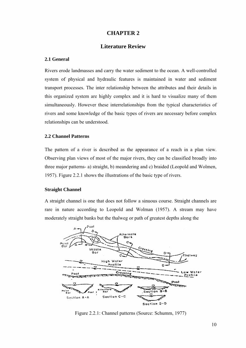
2.2 Channel Patterns
The pattern of a river is described as the appearance of a reach in a plan view.
Observing plan views of most of the major rivers, they can be classified broadly into
three major patterns- a) straight, b) meandering and c) braided (Leopold and Wolmen,
1957). Figure 2.2.1 shows the illustrations of the basic type of rivers.
Straight Channel
A straight channel is one that does not follow a sinuous course. Straight channels are
rare in nature according to Leopold and Wolman (1957). A stream may have
moderately straight banks but the thalweg or path of greatest depths along the
Figure 2.2.1: Channel patterns (Source: Schumm, 1977)
11
Channel is usually sinuous. Straight channels with prismatic cross-section are not
typical in nature. It is only feasible for artificial channel.
To differentiate between straight and meandering channels and sinuosity of a river,
the relation between thalweg and length to down valley distance is most frequently
used. Sinuosity varies from 1 to 3. Sinuosity of 1.5 is taken as the division between
meandering and straight channels by Leopold et al.(1964). A series of shallow
crossings and deep pools is formed along the channels in a straight channel with a
sinuous thalweg developed between alternate bars (Figure 2.2.1).
Depending on the regime of the river, the erodibility of the banks, a straight channel
can remain as such, if a river is dredged as a straight channel. Seldom only part of a
river is straight, typically as stretch of a few miles in between two meander bend.
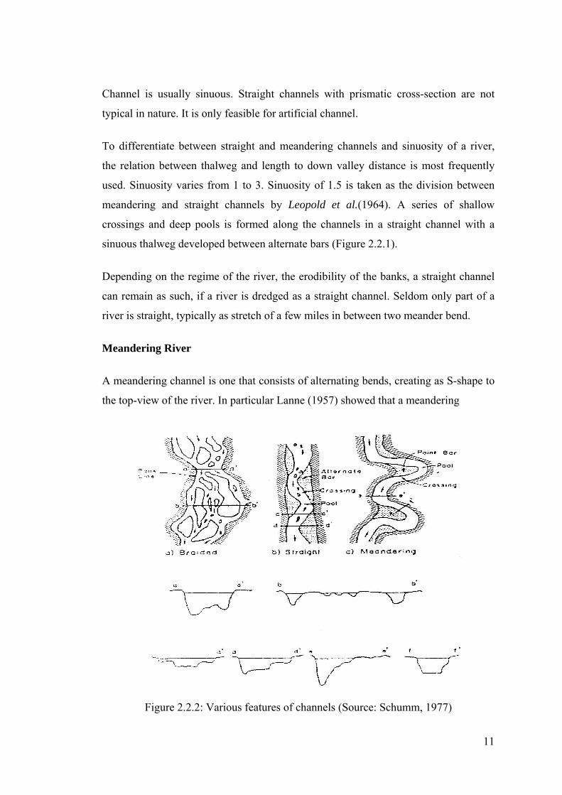
Meandering River
A meandering channel is one that consists of alternating bends, creating as S-shape to
the top-view of the river. In particular Lanne (1957) showed that a meandering
Figure 2.2.2: Various features of channels (Source: Schumm, 1977)

12
channel is one where channel alignment consists mainly of distinct bends, the shape
of which have not been established principally by the varying nature of the
topography through which the channel flows. The meandering river contains a
sequence of deep pools in the bends and shallow crossings in the short straight reach
connecting the bends. The thalweg flows from a pool through a crossing to the next
pool forming the typical S-curve of a single meander loop at higher stages. In the
severe case, the changing of the flow causes chute channels to develop across the
point bar at high stages.
Braided Channel
A braided river is one with generally wide and poorly delineated unstable banks, and
is depicted by a steep, shallow route with multiple channel divisions around alluvial
islands (Figure 2.2.2 (a)). Leopold and Wolmen (1957) studied braiding in a
laboratory flume. They deduced that braiding is one of many patterns that can
maintain quasi-equilibrium among the variables of discharge, sediment load and
transporting ability. The two primary reason that may be accountable for the braiding
is stated by Lane (1957) as: (1) Overloading, that is the channel may be full with more
sediment than it can transport consequently accumulating part of the load, deposition
occurs, the bed aggrades and the slope of the channel increases in an effort to
maintain a graded condition and (2) steep slopes, which generate high velocity,
multiple channels develop resulting the overall channel system to widen with rapidly
forming bars and islands. The multiple channels are generally unstable and change
position with both time and stage.
2.3 Factors influencing river geometry
Factors governing the geometry and roughness of an alluvial river are numerous and
interconnected. Their characteristic is such that it is difficult to single out and study
the function of a specific variable. Assessing the consequence of average velocity by
increasing channel depth will affect other correlated variables as well. Again, not only
will the velocity respond to change in depth, but also the form of bed roughness, the
position and shape of alternate, middle and point bars, the shape of cross-section, the

13
magnitude of sediment discharge and so on. Therefore, the study of the mechanics of
flow in alluvial channels and the response of channel geometry is incessant.
Variables influencing the geometry of alluvial rivers are numerous and some of the
important ones according to Simons (1971) are as follows:
V, D, S, ρ, μ, g, d, σ, ρs, SP, SR, fS, CT
Where,
V= Velocity
D= Depth
S= Slope
ρ = Density of water
μ = apparent dynamic viscosity of the water sediment mixture.
g = acceleration due to gravity
d = grain size of the bed materials
σ = measure of size distribution of bed materials
ρs = density of sediment
SP = shape factor of the reach of the stream
SR = shape factor of the cross-section of the stream
fS = seepage force in the bed of the streams
CT = concentration of the bed material discharge
Simons and Richardsen (1962) has described the role of the variables on resistance
and bed form. Simons (1971) also partially explained their significance on the channel
geometry.
2.4 Aggradation and Degradation of Channels
Aggradation (i.e. rising of the river bed by deposition) occurs in a river if the amount
of sediment coming into a given reach of a stream is greater than the amount of
sediment going out of the reach. Part of the sediment load must be deposited and
hence, the bed level must rise (Ranga Raju, 1980). In alluvial channels or streams bed
aggradation evolves primarily form the passage of flood events. The bed profile
consequently reduces the section factor of the channel. Sediment deposition along

14
streams or in reservoirs is a complex and troublesome process. It creates a variety of
problems such as, rising of river beds and increasing flood heights, meandering and
over flow along the banks, chocking up of navigation and irrigation canals and
depletion of the capacity of storage reservoir (Hossain, 1997).
Bed degradation (i.e. lowering of the bed by scouring) occurs when the amount of
sediment coming into a given reach of a river is less than the amount of sediment
going out of it (Ranga Raju, 1980). The excess sediment required to satisfy the
capacity of the river will come from erosion of the bed and there will be lowering of
the bed level, which will result in shifting of thalweg line of the river. If the banks are
erodible material can be picked up form the banks and widening of the river will also
result. Hence the whole process of aggradation and degradation of rivers have
potential effects on various hydraulic and geometric features of rivers such as cross-
sectional area, section factor, shifting of thalweg line etc.
2.5 Selection of study area
The study area has been selected from the confluence of the Bhrahmaputra and Padma
river to the lower end of Meghna river where the Meghna meets the bay of Bengal.
The study area is depicted in the following figure:
Figure 2.5: Study area selection

15
2.6 Environmental Condition of the Study area
The process of natural development of the selected islands of Meghna Estuary is
governed by the environmental conditions. Rainfall in the catchment is drained by
the rivers to the Bay of Bengal. Heavy monsoon rains causes high water levels in
the rivers that flood the land, while very high discharge brings enormous amounts
of sediments down the rivers to the estuary. The processes of accretion and erosion
are strongly influenced by the changes in the river flow, but also by waves. Winds
drive the circulation of water in the estuary while cyclones cause high storm
surges and (sometimes catastrophic) floods. Tide coming from the Indian Ocean
determines the variation in water levels and the flow in the estuary. Saline
seawater penetrates through the estuary up to Chandpur during the dry season,
while during monsoon the estuary is merely filled with fresh water. Changes in
salinity contribute to flocculation and deposition of silts in the estuary (Ali, 1996).
Knowledge of environmental conditions in the Meghna Estuary is therefore of
crucial importance for understanding the morphological processes. These
conditions are described in the following articles.
2.6.1 Precipitation
The climate of Bangladesh is tropical, with a hot, humid summer (March to June),
a rainy monsoon (June to September) with predominantly south-westerly monsoon
winds, and a dry, relatively cool winter (September to June) with predominantly
north-westerly monsoon winds. The catchment of Brahmaputra,
Jamuna-Meghna receives annually an average of 1,500 mm of rainfall, most of which
falls during the monsoon months but there are great variations in rainfall across the
basin. The average rainfall in the coastal area of Bangladesh is about 2000-3600
millimeters per year.
2.6.2 Wind
The wind regime along the Bay of Bengal shows a typically seasonal variation
between the dry season (November-March) and the monsoon season (June

16
September). During the dry season the prevailing winds are calm and offshore. The
prevailing winds during the monsoon season are from the S-SE direction, with an
average velocity of about 8-12 m/s. During severe storms and cyclones, very high
wind velocities can occur. The highest wind speed, reported during the April 1991
cyclone (CERP-II, 2000), is 62.5 m/s, corresponding to 225 km/h. Most cyclones
occur during April-May and October-November, which are the transitional periods
between the dry season and the monsoon season. The highest wind speed recorded in
the recently (November 7, 2007) occurred devastating cyclone SIDR was 250 km/h
that swept in from the Bay of Bengal.
Monthly average wind speed data as recorded at the study area of Lower Meghna
River, the coastal stations are presented in Table 2.5.1
Table 2.6.1 Average monthly wind speed in coastal stations (m/s)
Station Jan Feb Mar Apr Ma Jun Jul Aug Sep Oct Nov Dec Bhola 0.3 0.4 0.7 1.2 1.0 0.9 0.9 0.8 0.5 0.2 0.2 0.2 Sandwip 0.6 0.9 1.7 2.6 2.3 2.7 2.6 2.4 1.5 0.8 0.5 0.6
(Source: CERP II, 2000)
The tidal wave from the Indian Ocean travels through the deep Bay of Bengal and
approaches the coast of Bangladesh approximately from the south. It arrives at
Hiron Point and at Cox's Bazar at about the same time. The extensive shallow area
in front of the large delta causes some refraction. Also some reflection of the tidal
wave occurs contributing to a significant amplification of the tidal wave in Hatiya
and Sandwip Channels. North of Sandwip Island and Urir Char occurrence of tidal
bores has been observed (Akhter and Mahmud, 2007).
2.6.3 Waves
No wave heights have been recorded during severe storms until now. In the dry
season the waves are generally less than 0.6 m with peak periods of 3 - 4 seconds.
During the monsoon season wave heights exceed 2 m with periods greater than 6
seconds.

17
Table 2.6.2: Offshore Significant Wave Heights (m)
Return Period (years)
Wind Speed (m/s)
Wave Heights in different Water depth 20(m) 15(m) 10(m)
5 46.6 7.6 6.1 4.5 10 53.2 8.2 6.6 4.9 25 60.9 9.0 7.2 5.3 70 68.5 9.6 7.8 5.7 100 71.0 9.9 7.9 5.9
The maximum wave height is limited by the water depth. Depth of water is co-
related to the wave height. Water depth of 20m is representative for a deeper part of
the continental shelf. In the estuary, depths are generally lower than the other part.
The water depth in the estuary is less than 5-l0m when the cyclone surge is taken
into account. Waves higher than 0.6-0.8 times of the local water depth will break
due to insufficient water depth. Still, waves higher than 5m may be expected in the
outer part of the estuary during a cyclone (IWM, 2005).
2.6.4 Sediment transport processes
Sediment transport processes form a crucial control in the estuarine processes and
evolution of the Meghna Estuary. The estuary is the route by which sediments are
transported from the major rivers to the Gulf of Bengal. On their way down the river,
continuous deposition, re-erosion and transport alter the composition of sediments.
Much of the coarser sediments become trapped on the floodplains of the rivers, only
being released at times of flood (Alam et al.,1998). The finer fractions are transported
into the estuary. There, the estuarine processes act as a filter on the sediment input,
and mixing can take place with sediment brought in from the sea. Additionally,
chemical alterations can occur within the estuary that can cause the surface properties
of some of the constituent particles to alter, affecting their potential deposition.
2.6.5 River profiles, bank erosion and bed material
Materials comprising the beds of alluvial have an important influence on river
geometry. Bed slopes at the headwaters of rivers are steep and the bed material is
relatively course. In general, both the bed material size and river slope decrease in the
downstream direction. Tractive force is not sufficient to move the longer materials

18
down stream, but the smaller material is transported out to the point where hydraulic
sorting essentially paves the bed with coarse materials characteristic of a reach
eventually partially decomposed with time due to abrasion and weathering so that, in
general, a continuous supply of material capable of being transported is available
(Mukherjee, 1995).
The river boundary in a given reach is constantly changing with such interacting flow
variables as velocity, depth, slope, density and viscosity of the water-sediment
mixture, concentration of bed-load discharge, concentration of suspended load
discharge and characteristics of the bed material. River bank stability depends on
these interrelated stream variables as well as on channel geometry (Rahman, 1980).
Bank erosion and retrogression or retreat occurs in many ways, primarily as a result of
one or a combination of the following:
1. Removal of soil particles from the bank surface either continuously or
intermittently over a period of time;
2. Sequential failures of small segments of bank material
3. Failure of a single large segment of bank material
2.7 Hydro-morphological studies of the rivers of Bangladesh
In Bangladesh there have been many studies done on the hydro-morphological
aspects such as hydraulic geometry, erosion/deposition and bed level variations in
many rivers. Most of these studies were carried out in the major rivers like the
Ganges, the Brahmaputra, the Meghna and the Teesta River.
2.7.1 Hydro-morphological studies carried out in Meghna River and
Meghna Estuary
MES, 1999 studied that several interventions were proposed at different locations
of the Estuary in order to reduce the loss of valuable existing land and
infrastructure from erosion. The interventions proposed for erosion control were
made of permeable spurs and bottom screens.

19
The locations identified for interventions under this study include the northeast
coast of Bhola in the Lower Meghna (12 km coastline between the villages of
Ilisha in the north and Chowkighata in the south), the east coastline of Bhola
(about 50 km between the villages of Chowkighata in the north and Betua in the
south), the right bank of the Upper Tetulia River (between Ilisha and Dasmonia),
the Mehendigamj-Hizla-Bhedarganj (about 40 km on the right bank of the Lower
Meghna), the Lakshmipur-Ramgoti (about 40 km riverbank on the left bank of the
Lower Meghna between Haimchar and Char Bouy), the North Hatiya (about 12 km
shoreline), and the west coast of Sandwip island (about 15 km in length).
MES-022 studied the long-term hydraulic and morphological process in the Meghna
Estuary can be stirred by gravitational circulation due to salinity gradients in the
pre-and post monsoon period.
The study estimated the strength of the gravitational circulation for the Shabazpur
main channel of the Meghna Estuary. The gravitational circulation was estimated
based on LRP measurements of salinity collected during pre- monsoon over the
period 1983-1986.
MES, 2001 The Meghna Estuary Studies (MES I and MES II) were the supporting
studies under FAP 5B of the Flood Action Plan (FAP). The FAP was initiated after
the disastrous floods in Bangladesh in 1987 and 1988, and it was a co-coordinated
action to study the flood problems of Bangladesh.
The main goals of the MES were as follows:
To collectively gather hydrological and morphological data;
To increase knowledge of the hydraulic and morphological processes in the
Meghna Estuary system;
To develop appropriate techniques (or efficient land reclamation and effective
riverbank protection;
To provide a Master Plan and Development Plan for the estuarine area
20
To enhance the knowledge of the complex morphological process in the Meghna
Estuary, a morphological study was carried out within the framework of the
Meghna Estuary Studies in the period 1995 to 2001.
2.7.2 Hydro-morphological studies in the river around the world
Over the past decades several studies have been made to evaluate morphological
changes of the major rivers in and outside of Bangladesh. Although the list
provided is not exhaustive, yet it provides some information in this respect.
Ranga-Raju (1980) did a study on the practical computation of degradation and
aggradation on alluvial river based largely on the works carried out in India. He
presented semi-empirical methods for computation of bed and water surface
profiles for some of the commonly encountered cases of aggradation.
Jain (1989) proposed a guide for estimating river bed degradation. The rate and
extent river bed degradation resulting from sediment interruption were determined
by means of computer based numerical experiment. He presented the results in the
form of algebraic relations that can be easily applied by practicing Engineers to
estimate the temporal and optimal river bed degradation during the preliminary
phase of the engineering designs. The proposed relationship for the bed
degradation has been verified with the field data of Missouri river.
Ramez, P., Paquier, A. and Bonnet, F. (2002) carried out a study on Influence of
sediment transport on the computation of water in the river Rhone. The showed that
the increase of the head losses due to bed forms is interpreted in the U-curves (ratio of
Strickler coefficients versus ratio of bottom shear stresses) and of S-curves (Strickler
coefficient versus discharge). This effect is stronger at dominant discharge. It can lead
to a rise of water level much higher than the final topographical change. For the
presented example of a reach of River Rhône near Bourg lès Valence, this rise is
estimated over 1 m for the dominant discharge of about 1200 m3/s.

21
CHAPTER 3
Data Collection and Methodology
3.1 General
In Chapter-2 the different theories and terminologies that are used in this study have
been discussed. In this chapter, the detailed methodology of analysis for determining
morphological changes of the selected Padma and Lower Meghna River under this
study will be presented.
3.2 Data Collection
In this study, the hydraulic geomorphology of the Padma and lower Meghna River
will be investigated with the help of GIS technology. To identify the trend of Bank
line shifting (Morphological change) of The Padma-Meghna River System over the
past 20 years by analyzing Satellite Image of the respective 1989, 1999 and 2009
years in ArcGIS. The study would also determine the possible appearance of new
lands and loss of lands with the help of GIS maps drawn with geo reference scale.
Satellite raster images will be collected for selected 3 different years from the United
States Geological Survey (USGS) websites. The images were taken from LANDSAT-
II. The images used in this study are shown below:
Figure 3.2.1: Satellite map of 1989 of the study area

22
Figure 3.2.2: Satellite map of 1989 of the study area
Figure 3.2.3: Satellite map of 1989 of the study area
3.3 Methodology
The collected satellite images of the Padma and Lower Meghna River (for 3
different years) will be put in ArcMap and the geo-referencing will be done using
another map which is previously geo referenced. With the geo referenced point all
the maps will be converted to a common scale. Then all the maps will be
superimposed to observe the deviation of the bank line of the river in different
years.

23
Superimposition of the map of 1989 and 1999 in ArcMap will show the erosion
or deposition along the river bank and the net area will be calculated to find the
actual Erosion or Deposition. Eventually appearance of new lands will show up
for further use. Similarly all the maps of 1999 and 2009 will be superimposed all
together to get the net erosion or accretion from 1989 to 2009.
The pictorial depiction of the whole process are shown below:
Step-1: Geo-Referencing the Map of study area with another geo-referenced
map.
Figure 3.3.1 Map geo-referencing
Step 2: Digitizing the map
Figure 3.3.2 Map Digitization

24
Step 3: Overlapping the maps one over another
Figure 3.3.3 Map overlapped
The whole process will show the land area eroded or accreted within this 20 years
span thereby it would also show the shifting of bank line of the rivers. The islands
inside the rivers would also be calculated to carry further analysis.
25
Chapter 4
Results and Discussion
4.1 Results Discussion:
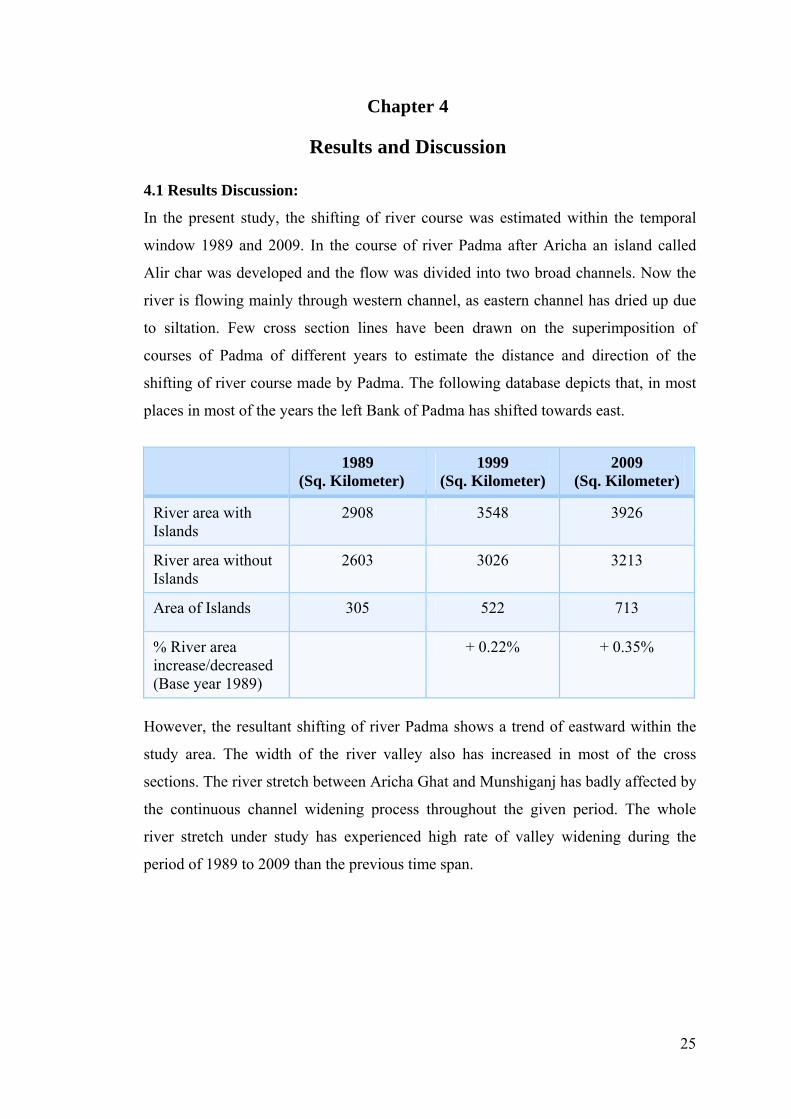
In the present study, the shifting of river course was estimated within the temporal
window 1989 and 2009. In the course of river Padma after Aricha an island called
Alir char was developed and the flow was divided into two broad channels. Now the
river is flowing mainly through western channel, as eastern channel has dried up due
to siltation. Few cross section lines have been drawn on the superimposition of
courses of Padma of different years to estimate the distance and direction of the
shifting of river course made by Padma. The following database depicts that, in most
places in most of the years the left Bank of Padma has shifted towards east.
1989 (Sq. Kilometer)
1999 (Sq. Kilometer)
2009 (Sq. Kilometer)
River area with Islands
2908 3548 3926
River area without Islands
2603 3026 3213
Area of Islands 305 522 713
% River area increase/decreased (Base year 1989)
+ 0.22% + 0.35%
However, the resultant shifting of river Padma shows a trend of eastward within the
study area. The width of the river valley also has increased in most of the cross
sections. The river stretch between Aricha Ghat and Munshiganj has badly affected by
the continuous channel widening process throughout the given period. The whole
river stretch under study has experienced high rate of valley widening during the
period of 1989 to 2009 than the previous time span.

26
Figure 4.1 Degraded area in Sq. Kilometer
Figure 4.2 Inside Island area in Sq. Kilometer

27
CHAPTER 5
Conclusion and Recommendation
The following conclusion can be drawn from the study carried out:
• All the Channel Morphometry Indices show a rising trend within the time span
considered in the study which actually indicates the severity of the changes in
river course and its morphology in coming future.
• Analyzing the data it was found that the river area was increased from 2908 sq
Kilometer to 3926 sq. kilometer in a span of 20 years from 1989 to 2009.
• The area of inward Islands also increased significantly which means that the
river system has lost the sediment carrying capacity over the years.
• The shifting process of river course and its subsequent erosion and accretion
processes cause the loss and newly formation of land simultaneously. But problem
is occurred when the amount of loss increases.
• The digitized files can be used as a useful tool for the water resources engineer
to find the optimum location for embankment for flood protection.
So the trend and severity of the change in channel morphology made by Padma and
Lower Meghna creates a vulnerable situation at present, which requires a good
management plan specially to protect the cultural landscapes.

28
References
1. Ali, A. (1996), “Vulnerability of Bangladesh to climate change and sea level rise through
tropical cyclones and storm surges”, Water Air and Soil Pollution, Vol. 92, Issue 1-2, pp.
171-179.
2. Alam, M. K. and Hosain, M. M. (1988), “Sediment transport in the River Jamuna”,
Journal of Institution of Engineers, Bangladesh, Vol. 16, Issue 1-2, pp. 17-26.
3. Bangladesh Water Development Board (2002), “Bangladesher Nod-Nodi”, BWDB, pp.
115-120.
4. Bangladesh Meteorological Department (1994), “Cyclone warning and flood forecasting
in collaboration with Bangladesh Meteorological Department (BMD)”, Yearly
preceeings, Vol. 1, Issue 1, pp. 29-32.
5. Coleman, J.M. (1969), “Brahmaputra River: Channel Process and sedimentation,
Sediment Geol”, Vol. 3, pp. 129-239.
6. Debnath, D. (2004), “A study on hydraulic geometry of selected minor rivers of north-
west Bangladesh”, M. Engg. Thesis, Dept. of Water Resources Engineering, BUET,
Dhaka.
7. Habibullah, M. (1987), “Computer Modeling of River Chanel Changes in Alluvial
Condition”, First Interim Report R 02/87, IFCDR, BUET, Dhaka.
8. Hossain, M. M. (1991), “Problems of erosion and deposition in the major Rivers of
Bangladesh”, Proc. Intern. Symp. On special problems of Alluvial Rivers including those
of International Rivers, Seoul, Korea, September 16-19, pp.247-255.
9. Hossain, M. M. (1992), “Total sediment load in the Lower Ganges and Jamuna”, Jr.
Institution of Engineers, Bangladesh, Vol. 20, Issue 1-2, pp. 1-8.
10. Hossain, T. B. (1997), “A study on Aggradation and Degradation of the Khowai River”,
M. Engg. Project, Dept. of the Water Resources Engineering, BUET, Dhaka.
11. Islam, M.R. (2004), “Where land meets the sea: A profile of coastal zone of Bangladesh”,
The university Press Ltd.

29
12. Jakobsen, F., Azam M. H. and Mahboob-ul-Kabir M. (2001), “Residual Flow in the
Meghna Estuary on the Coastline of Bangladesh”, Journal of Estuarine, Coastal and Shelf
Science, Vol 55, Issue 1, pp. 587-597.
13. Lasarte, A. E., Rasmussen, P. B. K. and Hassan, A. (1991), “Salinity intrusion in rivers in
Bangladesh”, Proceeding, International symposium on environmental hydraulics (Hong
Kong).
14. Majumdar, S.S, (2005)“Application of Remote sensing and GIS in identification of
morphological changes in the river Ganga”, An independent study paper submitted to the
civil engineering department of Jadavpur university of Kolkata, India.
15. Milliman, J.D. (1991), “Flux and fate of fluvial sediment and water in coastal seas”, In:
Mantoura, R.F.C., Martin, J.M. and Wollast, R., “Ocean Margin Processes in Global
Change”, John Willey and Sons Ltd., Chichester, pp. 69-89.
16. Murad S.W. and Rahman, M.Z. (2006), “Calculation of sediment transport rate for lower
Meghna River at Chandpur”.
17. Ranga Raju, K. G. (1980), “Aggradation and Degradation”, Proceedings of the
International Workshop on Alluvial River Problems held at Roorkee, India, March
18-20.
18. SWMC (2001), “Morphological Assessment of Rivers of Bangladesh”, Final Report.
19. WARPO (1997), “Sedimentation and Morphology Investigation”, Feasibility Study,
Draft Report submitted by FAP-6.
20. Yanapirut, N. (1985), “Channel Bed Degradation caused by Constriction”, AIT Thesis,
No. WM-85.