introduction of beacon control points using iot · introduction of beacon control points using iot...
TRANSCRIPT
Introduction of Beacon Control Points Using IoT
JungKyu Lee, Republic of Korea
Key words: Internet of Things(IoT), Cadastral Control Point, Beacon
SUMMARY
Currently in Korea, management of cadastral control points is entrusted by LX(Korea Land and
Geospatial Informatix Corporation), but the problems of points managements still occur because of
point loss for road pavement, a manpower shortage and so on. To solve these problems, LX
corporation is studying and developing cadastral control points system using Beacon.
A beacon is a Bluetooth 4.0-based low-power signal transceiver that detects and manages objects
and people within a 50-meter radius. Recently, various attempts have emerged according to the
developments in Internet of the Things(IoT). Among them, Beacon, wireless local area network
technology, is getting popular.
In cadastral surveying, the advantage of beacon control points is that it can be easily found through
a beep sound for control points within a certain distance of the mobile app. Therefore, it is effective
to find control points in areas covered with soil, leaves, snow or ice, and forest areas. It is also
possible to systematically manage digitized cadastral control points due to computerized surveys.
These beacons will bring innovation in surveying and will be the basis for digitized surveying in the
future world.
The purpose of this paper is to examine the problems of current control points and introduce the
beacon to be used as survey control points in Korea in the near future.
Introduction of Beacon Control Points Using IoT (9159)
JungKyu Lee (Republic of Korea)
FIG Working Week 2017
Surveying the world of tomorrow - From digitalisation to augmented reality
Helsinki, Finland, May 29–June 2, 2017

Introduction of Beacon Control Points Using IoT
JungKyu Lee, Republic of Korea
1. INTRODUCTION
1.1 Summary
In cadastral surveying, boundary surveying is an important measure to ensure the protection of the
land property rights of the people. For boundary surveying, the cadastral control point survey for
the installation of the control point is carried out first. The position of one parcel boundary point is
determined based on these control points. Therefore, accurate maintenance and management of
cadastral control points is essential.
Point name
Last year
cumulative
Installation performance
disposal
Sum
Management status
total New-
install
Re-install perfection disposal ETC
total 784,212 55,146 45,034 5,011 14,095 815,151 800,760 13,058 1,063
Cadastral
Triangulation
point
4828
74
71
4
12
4,887
4,607
170
110
Sub
Triangulation
point
33,329
2,798
2,108
112
1,114
34,323
33,744
209
100
Cadastral
Supplementary
point
746,055
52,274
42,855
4,895
12,969
775,941
762,409
12,679
853
(unit: Point)
Figure1 : Yearbook of Cadastre Statistics, 2015
In the table, the cadastral triangulation point is the point where the initial surveying is made from
the origin, and most of it is buried at the top of the mountain, so the frequency of loss or disposal is
relatively small. Cadastral sub-triangulation point is installed in the middle of the mountainside or
on the roof of the building. However, cadastral supplementary point is the point for boundary
surveying, because it is mainly installed around the city road, and the frequency of being lost by
various road works is quite high. In this paper, all of the control points I mentioned are related to
those Cadastral supplementary points.
Introduction of Beacon Control Points Using IoT (9159)
JungKyu Lee (Republic of Korea)
FIG Working Week 2017
Surveying the world of tomorrow - From digitalisation to augmented reality
Helsinki, Finland, May 29–June 2, 2017

Figure2 : Cadastral Triangulation point, SubTriangulation point in Korea
Figure3 : Cadastral Supplementary point in Korea
1.2 Problems of cadastral control point management
Currently, in Korea, the cadastral control point is entrusted and managed by LX(Korea Land and
Geospatial Informatix Corporation). However, considering the problem of management, when you
pave the road, you lose the control point. The investigation is not timely due to the lack of
manpower and equipment to investigate the control point. But the budget is scarce and this vicious
cycle repeats. Therefore, proper investigation and management are not being carried out. It can be
an important factor to increase the error in setting the land boundary due to the repeated practice of
the new installation and restoration of the control point. To solve these problems, we are studying
and developing a control point system using IoT.
2. MAIN SUBJECT
2.1 Concepts and Features of Internet (IoT)
The Internet of Things provides the Internet connectivity between various devices by utilizing
various network technologies (RFID, NFC, Beacon, WiFi, Bluetooth, ZigBee, GSM, GPRS, 3G and
LTE etc.) The term IoT was invented by Kevin Ashton of the 1999 MIT Auto-ID sensor. The term
"IoT" was proposed by the Internet connection of objects through RFID (Radio Frequency
Identification) technology.
Introduction of Beacon Control Points Using IoT (9159)
JungKyu Lee (Republic of Korea)
FIG Working Week 2017
Surveying the world of tomorrow - From digitalisation to augmented reality
Helsinki, Finland, May 29–June 2, 2017

In the International Telecommunication Union (ITU) standardization part, the report "The Internet
of Things" shows that "everything in the world". In other words, it is defined as information and
communication technology that allows people to communicate with each other and objects and
objects anytime and anywhere by connecting various devices to the network.
The Internet of things is the ultimate goal of ubiquitous computing. That is to say, it is possible to
freely access the network anytime and anywhere to operate not only personal communication but
also various devices located in a separate space, or to share information acquired through such
devices in real time. The Gartner Research Institute predicts that the Internet of things will spread in
earnest in 2020. Approximately 30 billion to 2 trillion digital devices are expected to participate
permanently or temporarily as network entities in the Internet of Things, according to the Gartner
Research Institute.
The Internet consists of four core concepts: Connect, Identify, Locate, and Inquire. First, all devices
are connected to the network. In other words, the Internet of Things requires a technology capable
of integrating various devices into a network away from existing human-centered networks. Second,
the Internet of things requires identification. Since a myriad of devices other than humans are
connected by a network, the Internet of Things needs the ability to identify each network entity.
Third, after the subject of the network is identified, the Internet must have the ability to know where
each subject is located. The three existing core concepts have already been technically completed.
Nonetheless, it takes time for the appearance of the Internet of things because of the final concept,
the implementation of Inquire. That is to say, there is a need for technologies that enable objects
(non-human) or devices to actively network and interact with other entities.
2.2 Beacon
A beacon was originally a device for receiving radio waves radiated from a ground wireless base
station, etc., in devices such as airplanes, ships, and automobiles, and acquiring various information
including positions. However, since 2013, the term "beacon" has been used in a narrow sense to
refer to short range data communication technology that detects smart devices within short distance
and provides various information and services based on Bluetooth low energy (BLE) technology.
The beacon itself serves as a reference point for locating information, and the actual information
transmission is based on a short distance communication technology such as Bluetooth or infrared.
Depending on the type of signal transmitted, a low frequency beacon, an LED beacon, a Wi-Fi
beacon, a Bluetooth beacon. Since the announcement of Apple's beacon technology, ‘iBeacon’ in
June 2013, Bluetooth low-energy (BLE) -based beacon technology is commonly referred to as a
beacon. This technology corresponds to a short-range wireless communication technology using a
Bluetooth 4.0-based protocol.
The beacon can operate with a small amount of packet transmission, does not require pairing to
connect the two devices, and communicates at low power, so it can recognize the location at a lower
cost than other short-range wireless communication technologies.
Introduction of Beacon Control Points Using IoT (9159)
JungKyu Lee (Republic of Korea)
FIG Working Week 2017
Surveying the world of tomorrow - From digitalisation to augmented reality
Helsinki, Finland, May 29–June 2, 2017

Near-field communication (NFC) can communicate only within a distance of less than 20 cm, while
beacons are non-contact, supporting up to 50 meters of distance. In addition, it is possible to locate
the device within the error range of 5cm. Since it is possible to provide both one-to-many and
many-to-many services, it can provide a variety of active services such as advertisement and
information transmission, home automation and payment.
This can be used to automatically give coupons or points to shop visitors according to whether they
are visiting the store or to provide an automatic explanation service for works currently watched by
visitors at exhibitions or museums. It is also possible to remotely grasp the state of crops and
machines by installing beacons with acceleration sensors or temperature / humidity sensors.
2.3 Domestic and overseas related industries
2.3.1. Domestic
(SKT) SK Telecom has developed the world's first IoT hybrid network (low power wireless internet
network), and 'Keyco' which is child and companion animal location tracker, 'Smart Talk' which
informs the car owner about real time vehicle information through shock sensor, IoT black box
Products.
(KT) KoreaTelecom has developed NB-IoT (low-power long-distance network) and has plan to
provide child safety, personal high-priced assets, and companion animal location service using
'Multi-use Position Tracker' which is a mobile terminal.
(Samsung) Samsung acquired SmartThings, an American IoT company, and has signed an MOU
with KEPCO(Korea Electric Power Corporation). And they will provide automatic electricity usage
control services using smart home appliances.
2.3.2. Oversea
(Google) Google is taking advantage of the Android platform, which takes up half of the mobile
market. IoT platform 'Android Things' and 'smart home' smartphone 'Google Home'.
(GE) In order to apply IoT to the industrial internet field, General Electronic has developed a cloud-
based predix platform to promote the IoT platform based on world-class technology in the
healthcare and medical devices as well as the precision aviation industry.
(IBM) Based on intelligent CEP / analysis platform and world-class artificial intelligence computer
Watson, we are building various IoT services around the world in connection with superior
technologies such as large data analysis and real-time data analysis and cloud. And plans to provide
intelligent services through the linkage of Siri and Watson.
2.4 Implementation and testing of IoT control point system
2.4.1. Exclusive beacon of LX
Introduction of Beacon Control Points Using IoT (9159)
JungKyu Lee (Republic of Korea)
FIG Working Week 2017
Surveying the world of tomorrow - From digitalisation to augmented reality
Helsinki, Finland, May 29–June 2, 2017

Figure4 : BLE Board product
• We designed a small beacon shape (hereinafter referred to as LXcon) that can be inserted into the
head of the control point because it is buried under the ground according to the characteristics of the
cadastral control point.
It transmits and receives BLE information by communicating with AP (Access Point). We have
developed a battery attachment unit that can accommodate several coin cells on the back side of the
PCB so that it can support more than double the lifetime of existing beacon from control through
firmware development.
• When existing beacons are buried in the ground, it is difficult to send out normal signals.
Therefore, a press antenna is implemented and mounted on the cover part to improve the Bluetooth
receiving distance performance.
• An antenna sample is prepared and tested. We concluded that maximum efficiency occurs when
the length of the antenna is extended by 3mm. We have also asked a certified signal testing and
certification company to compare the signal strength.
Introduction of Beacon Control Points Using IoT (9159)
JungKyu Lee (Republic of Korea)
FIG Working Week 2017
Surveying the world of tomorrow - From digitalisation to augmented reality
Helsinki, Finland, May 29–June 2, 2017
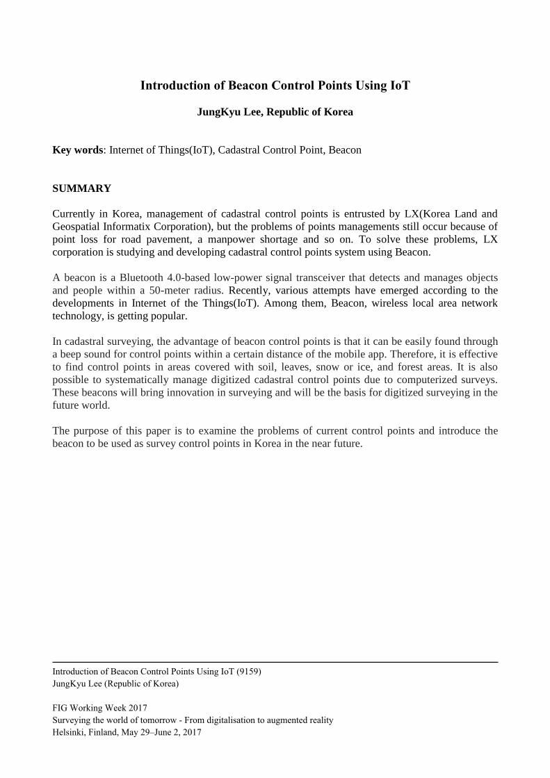
Figure5 : Work Flow Chart
2.4.2. Beacon control point production
• It is divided into for a paved road and for a non-paved. Each control point is made of Lego type so
that LXcon can be attached and detached.
• The center '+' mark of the control point body is positioned so that the observation value is not
changed during installation, and the module shape attached can support the center of the control
point in alphabet C shape.
• LXcon maintenance is easy because it is possible to remove the cover after installation.
In our work, beacon control points were divided into paved-road and non-paved road point. And we
have built the BLE module which is installed from Bluetooth 4.0. First, the beacon control point for
paved-road was constructed by fixing nail to the center of BODY, and BLE module was installed in
100mm diameter BODY. Module and cover can be removed.
Technical review and system design STEP 1
WORK FLOW
Production of LX beacon
(including reference point model)
STEP 2
S / W development STEP 3
Demonstration Area Testing and Testing STEP 4
Introduction of Beacon Control Points Using IoT (9159)
JungKyu Lee (Republic of Korea)
FIG Working Week 2017
Surveying the world of tomorrow - From digitalisation to augmented reality
Helsinki, Finland, May 29–June 2, 2017

Figure6 : Point for a paved-road
Figure7 : Point for a non paved-road
The point for non-paved road is shown in the following figure. The center + mark is fixed, the lid
can be fastened and removed, and the BLE module is replaceable.
Introduction of Beacon Control Points Using IoT (9159)
JungKyu Lee (Republic of Korea)
FIG Working Week 2017
Surveying the world of tomorrow - From digitalisation to augmented reality
Helsinki, Finland, May 29–June 2, 2017

Figure8 : Beacon Control Point Application
2.4.3. Beacon control point service system development
• It can be divided into four software blocks: a control point display and inquiry function, a control
point detail display function, a control point addition / correction / deletion management function,
and a BLE control point setting function of requirements of a beacon control point management
application.
• The beacon control point interworking interface is implemented through the Java web proxy
module without directly querying the service DB.
2.4.4. Develop application for inquiry
• The beacon control point application for inquiry was developed based on Android 4.3 or higher
and 8-inch tablet UI for inquire existing control points and managing and finding new beacon
control points.
• The total communication specification according to service request and response is seven, and can
be divided into application login, list request, detailed information request, information storage,
detailed information storage, beacon information storage, and control point information deletion.
Introduction of Beacon Control Points Using IoT (9159)
JungKyu Lee (Republic of Korea)
FIG Working Week 2017
Surveying the world of tomorrow - From digitalisation to augmented reality
Helsinki, Finland, May 29–June 2, 2017
• If the registered beacon control point exists around the user, the intelligent control point is
displayed in gray on the screen, orange when the intelligent control point is scanned, and blue in the
normal type.
• Clicking on the orange control point (scanned beacon control point) displays the RSSI (Receive
Signal Strength Indicator) while performing the scanning continuously.
The tag location recognition method using the RSSI value is one of the distance free methods with
relatively high positioning accuracy.
• The system implementation for recognizing the beacon control point of mobile device apps has
generated the beep sound for the nearest beacon control point.
• The distance is calculated according to the signal for the set geo-fencing event is processed. The
constraint condition of the recognition distance is given as 10m, 5m, 3m and the orientation is
indicated by scanning around the control point.
2.4.5. Burial and Testing in the Test Area
• In order to evaluate the performance of the cadastral control point survey system that reflects the
implemented beacon, the selected test areas are centered on urban and rural complexes,
compartmentalized districts or definite districts, Gyeonggi-do Bucheon-City, Sejong-City, and
Gimje-City.
• The installation target for the test was the Cadastral Supplementary point, and the prototype was
built with the help of the field staff in some areas of the site installation area.
Introduction of Beacon Control Points Using IoT (9159)
JungKyu Lee (Republic of Korea)
FIG Working Week 2017
Surveying the world of tomorrow - From digitalisation to augmented reality
Helsinki, Finland, May 29–June 2, 2017

Figure9 : Installing and Testing Beacon Control Points
• The test object was tested by using four types of BLE modules and control point shape, embedded
in parallel with the ground, and then tested in the form of forced interference through water, soil,
and hay.
• When commercial beacons were embedded, the signal was detected only within 3m. Especially,
the closer the control point to the ground, the shorter the signal distance. As a result, the prototype
test confirmed that the PCD integrated antenna reduces the radiation efficiency during landfilling.
2.4.6. Result
• Three LXcons with improved antennas and four other commercial beacons were assumed to have
interference conditions.
• In a normal buried condition, it has been confirmed that the improved LXcon with an antenna
greatly improves reception strength.
• In the pile of hay, there was no significant difference between the normal product and the control
group, but in the case of water, the signal intensity was reduced by half (average 10m) in addition to
the refraction phenomenon.
Introduction of Beacon Control Points Using IoT (9159)
JungKyu Lee (Republic of Korea)
FIG Working Week 2017
Surveying the world of tomorrow - From digitalisation to augmented reality
Helsinki, Finland, May 29–June 2, 2017

• If the beacon control point is buried in a farmland or forest area where the communication is
difficult to cover, such as dirt, leaves, or areas where there is a high possibility of being covered
with an interference material such as snow or ice, it may be effective.
• The prototype product and system implemented through the research have clearly detected the
function within the minimum distance of 5m from the control point and perform better than the
existing beacon.
Introduction of Beacon Control Points Using IoT (9159)
JungKyu Lee (Republic of Korea)
FIG Working Week 2017
Surveying the world of tomorrow - From digitalisation to augmented reality
Helsinki, Finland, May 29–June 2, 2017

Figure10 : Test Results
Figure11 : Test Results
Introduction of Beacon Control Points Using IoT (9159)
JungKyu Lee (Republic of Korea)
FIG Working Week 2017
Surveying the world of tomorrow - From digitalisation to augmented reality
Helsinki, Finland, May 29–June 2, 2017
2.5. Benefits of Beacon Control Points
In cadastral surveying, the advantage of a beacon control point is that it can be easily found through
a Beep sound for a control point within a certain distance of the mobile app. Therefore, it is
effective to find a control point in a forest or an area where there is a high possibility of covering
with soil, leaves, heavy snow or ice.
It is also possible to systematically manage digitized cadastral control points due to computerized
surveys. And if you use beacon technology, you can solve the problem of manpower because you
can reduce the number of current 2-person investigation to 1 person. And research results show that
it can shorten the investigation time and is excellent for budget reduction. Therefore, it will be able
to overcome the problem that can not be investigated periodically every year.
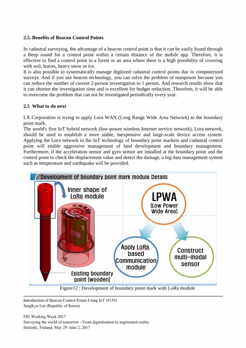
2.5 What to do next
LX Corporation is trying to apply Lora WAN (Long Range Wide Area Network) to the boundary
point mark.
The world's first IoT hybrid network (low-power wireless Internet service network), Lora network,
should be used to establish a more stable, inexpensive and large-scale device access system.
Applying the Lora network to the IoT technology of boundary point markers and cadastral control
point will enable aggressive management of land development and boundary management.
Furthermore, if the acceleration sensor and gyro sensor are installed at the boundary point and the
control point to check the displacement value and detect the damage, a big data management system
such as temperature and earthquake will be provided.
Figure12 : Development of boundary point mark with LoRa module
Introduction of Beacon Control Points Using IoT (9159)
JungKyu Lee (Republic of Korea)
FIG Working Week 2017
Surveying the world of tomorrow - From digitalisation to augmented reality
Helsinki, Finland, May 29–June 2, 2017
3. CONCLUSION
So far, we have studied the outline of cadastral survey, the problem of current control point, and the
beacon control point as a solution method.
• Developed a prototype system by designing a private beacon and designing the LX beacon
platform model accordingly, and solving the problem that the signal distance is significantly
reduced when the beacon is buried in the ground.
• LXcon improves battery performance compared to commercial beacons in service in Korea. It is
developed as a special type for buried control point and supports strength and waterproof function
enough to withstand depositing and can also be used for general purpose.
• In order to verify the feasibility of the technology through the development of the LXcon platform
prototype, the test area was selected and tested, and it was confirmed that it could help find the
control point difficult to see.
• We will provide other types of beacon services using LXcon as we have secured a technological
basis to quickly provide new public services using LXcon.
• Examining the cadastral control points using beacon technology can reduce the manpower
required for the current cadastral control point investigation and reduce the time required for field
investigators to find cadastral control points.
• Management of cadastral control points can also be computerized. If AP equipment is upgraded
and a system of constant power supply is provided, it is expected that remote monitoring of the
control point of the country will be possible.
• In order for the research method that uses the beacon control point to be put to practical use, it is
necessary to analyze the results by carrying out an empirical test on more control points in the
future, and to propose a systematic and specific improvement plan such as related laws, regulations
and fees.
• Due to the nature of prototypes rather than mass-produced products, it is difficult to carry out tests
on various field conditions. Therefore, it is necessary to verify the reliability of the pilot project and
to conduct research to smoothly process a large amount of IoT communication data.
• Research should be done to find alternative batteries (eg Flexible Battery) and to reduce the size.
In the case of apps, research on how to optimize distance calculation according to RSSI is needed.
• On the beacon control point side, due to the difficulty of commercialization due to the cost of
additional production, it is necessary to find a specialized beacon service model that can protect the
property rights of the public with LXcon as public goods.
This will bring innovation in surveying and will be the cornerstone of digitized surveying in the
future world.
Introduction of Beacon Control Points Using IoT (9159)
JungKyu Lee (Republic of Korea)
FIG Working Week 2017
Surveying the world of tomorrow - From digitalisation to augmented reality
Helsinki, Finland, May 29–June 2, 2017
REFERENCES
-Kim, ChangKi, 2015, A study on Introduction of IoT Technology for Efficient Cadastral Control
Point Management
-Yeon, SungHyun 2016, A study on validation of introduction of beacon control point, Journal of
the Geospatial Information, vol.11, pp.62-69.
- Ministry of Land, Infrastructure and Transport Korea 2015, Year Book of Cadastre Statistics
BIOGRAPHICAL NOTES
JungKyu Lee
Education background: Feb,2011, Bachelor degree, Geoinformatics engineering, Inha University.
Current position: Assistant Manager, H.Q of Daejeon Chungnam-do, Korea Land And Geospatial
Informatix Corporation.
Main task : Creation of railway protection zone using continuous cadastral map
CONTACTS
Asst Manager, JungKyu Lee
Business office of Geo-informatics, Korea Land and Geospatial Informatix Corporation,
12Munjeong-ro 48beon-gil, Seo-gu, Daejeon, Republic of Korea
Tel. + 82 42 479 2186
Fax + 82 42 479 2168
Email: [email protected]
Introduction of Beacon Control Points Using IoT (9159)
JungKyu Lee (Republic of Korea)
FIG Working Week 2017
Surveying the world of tomorrow - From digitalisation to augmented reality
Helsinki, Finland, May 29–June 2, 2017