introduction - nec.gov.bt€¦ · web viewthe world bank has classified ... such glofs occur when...
TRANSCRIPT

National Environment Commission
& Department of Agriculture,
Royal Government of Bhutan
NATIONAL ENVIRONMENT COMMISSION
NATIONAL INTEGRATED WATER RESOURCES MANAGEMENT PLAN 2016
Draft 2, 31 January 2016

National Environment Commission
FOREWORD by His Majesty or the Prime Minister
ACKNOWLEGEMENT
In compliance with the Water Act and the 11th FYP, the Water Resources Coordination Division (WRCD), National Environment Commission Secretariat is pleased to present the National Integrated Water Resources Management Plan. It is the result of concerted efforts by different parties. Without their contribution this document would not have materialized.
WRCD likes to thank particularly the Asian Development Bank and Japan Fund for Poverty Reduction for the financial and technical support extended to the Integrated Water Resources Management (IWRM) program being pursued in Bhutan. Special thanks go to the National Environment Commission for guidance and approval of the plan, and the Ministry of Finance for facilitating the technical assistance from the Asian Development Bank.
WRCD is greatly indebted to the Technical Advisory Committee that has been established for guiding the development of the IWRM program and elaboration of the National Integrated Water Resources Management Plan. The Technical Advisory Committee consisted of representatives from the following agencies: Map Production Division, National Land Commission; Department of Public Health, Ministry of Health; Renewable Natural Resources Engineering Division, Department of Agriculture, Ministry of Agriculture and Forestry; Watershed management Division, Ministry of Agriculture and Forestry; Gross National Happiness Commission; Water and Sanitation Division, Ministry of Works and Human Settlements; Department of Disaster Management, Ministry of Housing and Cultural Affairs; Department of Local Governance, Ministry of Housing and Cultural Affairs; Flood Engineering Management Division, Ministry of Works and Human Settlement; Climate Change Division, National Environment Committee; Bhutan Chamber of Commerce and Industries; Department of Hydropower and Power Systems; Department of Hydro-Met Services; Department of Geology and Mines, Ministry of Economic Affairs; Tarayana Foundation; Royal Society for the Protection of Nature.
WRCD is also grateful to the Technical Assistance team of EGIS in joint venture with the Royal Society for the Protection of Nature and the Bhutan Water Partnership, who has put a lot of effort into the realization of the NIWRMP.
DISCLAIMER
Boundaries shown on maps are not necessarily authoritative.
iDraft National IWRM plan 2016
National Environment Commission
Acronyms
ADB Asian Development BankAWDO Asian Water Development OutlookBCCI Bhutan Chamber of Commerce and IndustriesBhWP Bhutan Water PartnershipBNWRI Bhutan National Water Resources InventoryBTFEC Bhutan Trust Fund for Environmental ConservationCD Capacity DevelopmentCDTA Capacity Development Technical AssistanceCFO Chief Forestry OfficerCMIP5 Coupled Model Inter-comparison Project Phase 5DAHO District Animal Husbandry OfficerDAO District Agricultural OfficerDDM Department of Disaster ManagementDEC District Environment CommitteeDEO District Environment OfficerDES Department of Engineering ServicesDG Director GeneralDGM Department of Geology and MinesDHPS Department of Hydropower & Power SystemsDMF Design & Monitoring FrameworkDOA Department of AgricultureDOFPS Department of Forest & Park ServicesDOHS Department of Hydromet ServicesDWS Drinking Water SupplyESD Environment Service DivisionFAO Food & Agricultural Organization (of the United Nations)FEMD Flood Engineering Management Division (MOWHS)FGD Focus Group DiscussionGIS Geographical Information SystemGLOF Glacier Lake Outburst FloodGNHC Gross National Happiness CommissionGNHCS Gross National Happiness Commission SecretariatHP Hydropower PlantsIT Information TechnologyIWRM Integrated Water Resources ManagementJICA Japan International Cooperation AgencyKPI Key Performance IndicatorKRA Key Result AreaMASL Meter above sea levelMOAF Ministry of Agriculture & ForestryMOEA Ministry of Economic AffairsMOF Ministry of Finance
iiDraft National IWRM plan 2016

National Environment Commission
MOH Ministry of HealthMOHCA Ministry of Home & Cultural AffairsMOWHS Ministry of Works & Human SettlementsMPR Monthly Progress ReportNEC National Environment CommissionNECS National Environment Commission SecretariatNIIS National Irrigation Information SystemNIMP National Irrigation Master PlanNIWRMP National Integrated Water Resources Management PlanNLC National Land CommissionNWRB National Water Resource BoardODE Organizational Development ExercisePHED Public Health Engineering DivisionPPT Power Point (Presentation)RBC River Basin CommitteeRBMP River Basin Management PlanRCSC Royal Civil Service CommissionRGOB Royal Government of BhutanRNR Renewable Natural ResourcesRSPN Royal Society for Protection of Nature (Bhutan)TA Technical AssistanceTAC Technical Advisory Committee (advising WRCD, NECS)TNA Training Needs AssessmentTOR Terms of ReferenceUNESCO United Nations Educational, Scientific and Cultural OrganizationWMD Watershed Management Division (DOFPS, MOAF)WRCD Water Resources Coordination Division in NECSWUAs Water Users Associations
iiiDraft National IWRM plan 2016

National Environment Commission
GLOSSARY
Integrated Water Resources Management
(IWRM).
IWRM is defined as ‘a process which promotes the coordinated development and management of water, land and related resources in order to maximise economic and social welfare in an equitable manner without compromising the sustainability of vital ecosystems’.1
IWRM components The components of IWRM are as follows:
1. Managing water at the basin or watershed level
This includes integrating land and water, upstream and downstream, groundwater, surface water, and coastal resources.
2. Optimizing supply
This involves conducting assessments of surface and groundwater supplies, analysing water balances, adopting wastewater reuse, and evaluating the environmental impacts of distribution and use options.
3. Managing demand
This includes adopting cost recovery policies, utilizing water-efficient technologies, and establishing decentralized water management authorities.
4. Providing equitable access
This may include support for effective water users’ associations, involvement of marginalized groups, and consideration of gender issues.
5. Establishing policy
Examples are implementation of the polluter-pays principle, water quality norms and standards, and market-based regulatory mechanisms.
6. Intersectoral approach
Utilizing an intersectoral approach to decision-making, where authority for managing water resources is employed responsibly and stakeholders have a share in the process.
IWRM pillars The three IWRM pillars relate to: (i) enabling environment (suitable policies, strategies, and legislation); (ii) capable institutional framework; and (iii) management instruments.
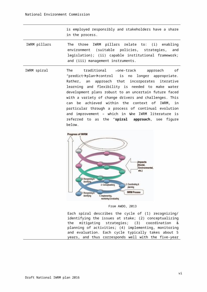
IWRM spiral The traditional one-track approach of “predictplancontrol” is no longer appropriate. Rather, an approach that incorporates iterative learning and flexibility is needed to make water development plans robust to an uncertain future faced with a variety of change drivers and challenges. This can be achieved within the context of IWRM, in particular through a process of continual evolution and improvement – which in the IWRM literature is referred to as the “spiral” approach, see figure below.
1 Global Water Partnership: http://www.gwp.org/The-Challenge/What-is-IWRM/
ivDraft National IWRM plan 2016

National Environment Commission
From AWDO, 2013
Each spiral describes the cycle of (1) recognizing/ identifying the issues at stake; (2) conceptualizing the mitigating strategies; (3) coordination & planning of activities; (4) implementing, monitoring and evaluation. Each cycle typically takes about 5 years, and thus corresponds well with the five-year planning practice of the GNHC in Bhutan. Conclusions from the evaluation of previous round of activities will lead to renewal or adjustment of plans in the next cycle.
River basin A river basin can defined as:2
The geographical area determined by the watershed limits of the system of waters, including surface and underground waters, flowing into a common terminus (cf. Helsinki Rules, International Law Association, 1966, article II).
Or:
A river basin is the portion of land drained by a river and its tributaries. It encompasses the entire land surface dissected and drained by many streams and creeks that flow downhill into one another, and eventually into the river and exiting the area at one point, see figure below.
2 https://docs.google.com/a/universitywatersectorpartnership.org
vDraft National IWRM plan 2016
National Environment Commission
Schematic presentation of a river basin
NB: A (drainage) basin is basically the same as catchment area or watershed. The distinction is mainly based on the scale of the area being referred to.
The Dublin principles for IWRM
IWRM strategies are based on the four principles formulated at a water conference in Dublin in 1992 (referred to as the Dublin Principles of IWRM) and presented to world leaders at the World Summit in Rio de Janeiro in 1992.
The four principles are: (i) water is finite and vulnerable resource; (ii) need for a participatory approach in water management; (iii) the role of women is stressed; (iv) water has social and economic value. Sometimes a fifth principle is added: (v) integration of the three E’s: economic efficiency – social equity – environmental sustainability.
Water security Defined as “the capacity of a population to safeguard sustainable access to adequate quantities of acceptable quality water for sustaining livelihoods, human well-being, and socio-economic development, for ensuring protection against water-borne pollution and water-related disasters, and for preserving ecosystems in a climate of peace and political stability.”3
Water availability The hydrologic capacity of a water source (surface water body, groundwater, municipal water) to sustain additional water demands after considering other current water uses and water conditions. (GEMI, 2012) 4
In the context of this NIWRMP the water availability in an area has been determined as runoff generated from rainfall within the concerned area augmented with the inflow from upstream areas.
Hydrological water balance
Any water entering a system (via precipitation), must be transferred into either evaporation, surface runoff (eventually reaching the channel and leaving in the form of river discharge), or stored in the ground. This equation requires the system to be closed (hydrological unit)5
3 UN-Water: http://www.unwater.org/topics/water-security/en4 http://www.iadclexicon.org/water-availability/ 5 https://en.wikipedia.org/wiki/Water_balance
viDraft National IWRM plan 2016
National Environment Commission
Water accounting The systematic study of the current status and future trends in water supply, demand, accessibility and use within a given spatial domain.6
6 http://www.slideshare.net/FAOoftheUN/i4-water-accountingtrainingsession
viiDraft National IWRM plan 2016

National Environment Commission
SUMMARY FOR THE EXECUTIVES1. Bhutan is faced with what could be dubbed as the ‘challenge at dual scale’.
At the larger scale of the river basins (and districts), there are no pressing water problems (yet). The challenge is about coordination and integration of plans for management of water. This is addressed in the Water Act and Regulations, along with the formation of River Basin Committees. The necessity to maintain sustainability of water utilization in future, has been elaborated further in the NIWRMP - specifying priority steps to be taken.
However, water-related problems are felt acutely at local level by dispersed communities living on the mountain slopes where they draw water from small (sometimes distant) sources and rivulets. Their problems cannot be attended at central or even basin level, and should be addressed at the level of villages and Gewogs.
2. Climate change is expected to result in higher temperatures and more (intensive) rainfall during the monsoon – when water is already plentiful. Extreme river discharges are expected to occur, calling for new design criteria for water works, and ‘room for the rivers’ so as to avoid flooding. Conversely, lean period flows are expected to be lower, with occasional spikes. Water retention at different altitudes in the terrain is opportune.
3. Water shortage as such has not been identified, but rather a problem with accessibility. Given the scattered habitation and the rugged mountain terrain, delivery of stable water supply is inherently costly.
4. Irrigation water demand is competing with water use for hydropower generation, not the other way round. It has been estimated that achieving full cereal self-sufficiency could substantially reduce the discharge of the main rivers in certain months of the year. The competition for water should be taken into account in the national policies towards food self-sufficiency and power generation, and taking ecological flows into account.
5. To support water management at smaller scale, it is essential to increase the number of weather and discharge monitoring stations and spreading them evenly throughout the country. In addition, Gewogs should document water resources and related issues in their areas for investigation and mitigation.
6. The Water Act and Water Regulation are sound and in harmony with other water-related legislation. There is however scope for fine-tuning.
7. Bhutan has five major and five minor hydrological basins. However, there are five management basins: (i) Amochhu; (ii) Wangchhu; (iii) Punatsangchhu; (iv) Mangdechhu; and (v) Drangmechhu. The River Basin Committees are designed along the ‘coordination model’, building as much as possible on existing institutions and keeping the regulatory and implementation mandates where they are already. The future will tell us how workable this is for the RBCs.
8. Planning, implementation and monitoring water security is built around the concept of the Bhutan Water Security Index comprised of five key dimensions: (i) Rural drinking water supply and sanitation; (ii) Economic water security; (iii) Urban drinking water supply, sanitation and drainage; (iv) Environmental water security; and (v) Resilience to disaster and climate change. The water security is expressed in an index figure and visualized in a spider web diagram of the five key dimensions. Agency coordination is structured along the key dimensions and indicators.
9. There is an acute need to strengthen the capacity of NECS for implementation of the Water Act and the NIWRMP. There is also an urgent need to strengthen the DOA for implementation of the National Irrigation Master Plan in the context of achieving food self-sufficiency. Lastly, DHMS should be strengthened and reoriented to become a broad service provider to other agencies in terms of weather forecasting and hydrological assessments.◊
viiiDraft National IWRM plan 2016
National Environment Commission
ixDraft National IWRM plan 2016

National Environment Commission
NATIONAL INTEGRATED WATER RESOURCES MANAGEMENT PLAN 2016
Contents1 INTRODUCTION.......................................................................................................................................... 1
1.1 BACKGROUND..........................................................................................................................................11.2 MAIN ISSUES TO BE ADDRESSED REGARDING IWRM........................................................................................11.3 OBJECTIVES OF THE NIWRMP....................................................................................................................21.4 STRUCTURE OF THE NIWRMP....................................................................................................................11.5 CONSULTATIONS DURING PREPARATION OF THE NIWRMP...............................................................................1
2 COUNTRY CONTEXT.................................................................................................................................... 3
2.1 LOCATION...............................................................................................................................................32.2 PHYSICAL FEATURES...................................................................................................................................32.3 SOCIETY AND CULTURE...............................................................................................................................42.4 ECONOMY...............................................................................................................................................52.5 GOVERNANCE SYSTEM...............................................................................................................................62.6 HYDROLOGICAL CONTEXT............................................................................................................................8
3 WATER-RELATED ISSUES........................................................................................................................... 13
3.1 INADEQUATE COORDINATION....................................................................................................................133.2 WATER AVAILABILITY IS STRONGLY SEASONAL...............................................................................................133.3 MULTI-PURPOSE RESERVOIRS....................................................................................................................143.4 WATER-SCARCE AREAS.............................................................................................................................153.5 WATER AVAILABILITY VERSUS ACCESSIBILITY.................................................................................................153.6 DEMAND MANAGEMENT..........................................................................................................................163.7 WATER AS COMMON POOL RESOURCE........................................................................................................173.8 AREAS PRONE TO MONSOON FLOODS..........................................................................................................173.9 GLACIAL LAKE OUTBURST FLOODS.............................................................................................................183.10 DRINKING WATER SUPPLY.........................................................................................................................183.11 AGRICULTURAL WATER USE.......................................................................................................................183.12 HYDROPOWER GENERATION......................................................................................................................193.13 COMPETITION FOR WATER........................................................................................................................223.14 IMPACT OF CLIMATE CHANGE....................................................................................................................233.15 WATER SOURCES DRYING-UP.....................................................................................................................263.16 POLLUTION AND WATER QUALITY...............................................................................................................283.17 LOSS OF AGRICULTURAL LAND....................................................................................................................283.18 LANDSLIDES...........................................................................................................................................283.19 OVER-GRAZING......................................................................................................................................293.20 FOREST FIRES.........................................................................................................................................293.21 SHIFTING CULTIVATION.............................................................................................................................29
4 GOVERNANCE FRAMEWORK..................................................................................................................... 30
4.1 EVOLUTION OF APPROACH TO WATER MANAGEMENT.....................................................................................304.2 OVERVIEW OF POLICIES AND LEGAL FRAMEWORK..........................................................................................31
xDraft National IWRM plan 2016
National Environment Commission
4.3 OVERVIEW OF THE NATIONAL PLANNING PROCESS AND ENTRY POINTS FOR IWRM..............................................354.4 WATER-RELATED PRIORITIES IN THE VISION, POLICY AND PLANNING.................................................................384.5 INSTITUTIONAL FRAMEWORK AND STAKEHOLDER ANALYSIS..............................................................................404.6 TECHNICAL TOOLS AND THEIR UTILIZATION...................................................................................................544.7 TRAINING NEEDS ASSESSMENT...................................................................................................................554.8 INSTITUTIONAL COORDINATION FRAMEWORK BASED ON THE BWSI..................................................................57
5 BHUTAN WATER SECURITY INDEX............................................................................................................. 58
5.1 CONCEPT...............................................................................................................................................585.2 DESCRIPTION.........................................................................................................................................585.3 STRUCTURE............................................................................................................................................585.4 COMPUTATION.......................................................................................................................................595.5 VISUALISATION.......................................................................................................................................605.6 NATIONAL AND BASIN-LEVEL SCORES OF THE BWSI.......................................................................................61
6 IWRM MANAGEMENT FRAMEWORK AT BASIN LEVEL................................................................................62
6.1 DELINEATION OF MANAGEMENT BASINS FOR IWRM.....................................................................................626.2 RIVER BASIN COMMITTEE AND ITS FUNCTIONS..............................................................................................636.3 RIVER BASIN MANAGEMENT PLANS.............................................................................................................67
7 PRIORITIES IN THE NATIONAL IWRM PROGRAM........................................................................................70
7.1 ADOPTION OF WATER SECURITY AS CONCEPT FOR COORDINATION IN IWRM PLANNING AND MONITORING..............707.2 DELINEATION OF AGENCY ROLES IN OPERATIONALIZING THE BWSI...................................................................707.3 DELINEATION OF RIVER BASINS FOR INTEGRATED WATER RESOURCES MANAGEMENT............................................707.4 RE-ALIGNMENT OF ADMINISTRATIVE BOUNDARIES ALONG HYDROLOGICAL UNITS.................................................717.5 RATIFICATION OF THE FRAMEWORK AND FUNCTIONS OF THE RBC....................................................................717.6 PREPARATION OF SUCCESSIVE RBMPS........................................................................................................717.7 STRENGTHENING THE CAPACITY OF NECS....................................................................................................717.8 STRENGTHENING THE CAPACITY OF THE DEPARTMENT OF AGRICULTURE............................................................737.9 STRENGTHENING THE WEATHER AND HYDROLOGICAL MONITORING AND FORECASTING CAPACITY............................747.10 TRAINING PLAN......................................................................................................................................757.11 FORMALISATION AND STRENGTHENING OF WATER USERS ASSOCIATIONS..........................................................797.12 IMPROVEMENT AND HARMONISATION OF THE LEGAL FRAMEWORK FOR IWRM..................................................83
SELECTED REFERENCES...................................................................................................................................... 85
APPENDICES TO THIS REPORT............................................................................................................................ 86
APPENDIX 1: AREAS IN BASINS AND DISTRICTS...........................................................................................................87APPENDIX 2: IWRM PLANNING AND COORDINATION FRAMEWORK BASED ON THE BWSI, AND RESPONSIBLE AGENCIES..........88
xiDraft National IWRM plan 2016
National Environment Commission
1 Introduction
1.1 BackgroundThe Kingdom of Bhutan is richly endowed with abundant water resources. However, owing to rugged topography and associated climatic variations, accessibility remains a major challenge with communities facing seasonal and local scarcity of water. Historically, water resources have been managed through community based traditional institutions focusing primarily on provision of water for drinking and irrigation. With the pursuit of economic development and increasing population, associated lifestyle changes and diversified utility of water has resulted in increasingly demand for water. Although the role of government in management of water has increased over the years, it is still constrained by weak coordination and regulatory mechanism characterized by government agencies pursuing their own sectorial objectives. Over the period of eleven five year plans, water for hydropower development, though non-consumptive, has received increasing focus with seemingly low priority on holistic balanced approach with respect to domestic water supply, irrigation, industrial and environmental water demand. With increasing consumptive demand, competition for water is emerging. The impact of climate change on water availability is a concern for drinking water supply, agricultural production and also for hydropower generation.
Recognizing that increasing pressure on the quality and quantity of water resources under rapid socio-economic development may further exacerbate with threats from changing climate, the Water Act of Bhutan 2011 was enacted to protect the environment and human health and to enhance the quality of lives through assured access to adequate, safe and affordable water. The Act identifies integrated water resources management (IWRM) as the approach in ensuring that the water resources are protected, conserved and/or managed in an economically efficient, socially equitable and environmentally sustainable manner. For this, the Act requires the National Environment Commission Secretariat (NECS) in consultation with competent authorities to 'prepare and periodically update a National Integrated Water Resources Management Plan for the conservation, development and management of water resources'. The Act requires the NEC and competent authorities to take account the approved plan in all water related decisions and that the plan be mainstreamed into national policies, plans and programmes.
In taking forward the Royal Government's drive for a more comprehensive management of the water resources, the NECS has initiated the preparation of the National Integrated Water Resource Management Plan (NIWRMP). This NIWRMP has been prepared under ADB-funded technical assistance titled 'Adapting to climate change through IWRM' under guidance of the NECS and the Technical Advisory Committee (TAC). The time horizon for this plan is the year 2030.
1.2 Main issues to be addressed regarding IWRMThe main issues to be addressed are summarised as follows:
• Agreement on common goals in water-related planning and management• Strong capacity and coordination of agencies involved in water management• Capturing the present status of water resources in terms of (i) water availability, demand and quality; (ii)
water-scarce and/or flood-prone areas; (iii) licensing of abstractions
1Draft National IWRM Plan 2016
National Environment Commission
• Assess the impact of main pressures on water management such as: climate change; change in land use; population growth, and economic development.
1.3 Objectives of the NIWRMPThe strategic purpose of the NIWRMP is twofold:
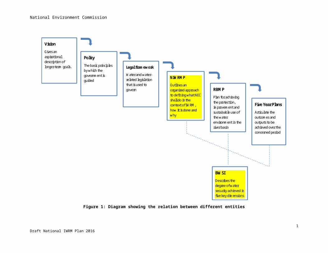
• To provide a bridge between the Vision, Policy statements and legal framework on the one hand and (Five Year) operational planning on the other hand, see figure 1 below.
• To outline priorities what NEC shall do during the plan period in the context of IWRM, how it is done and why.
The objectives of the NIWRMP are the following.
At strategic level:
• Identifying desirable and feasible goals/ Key Result Areas (what do we want to achieve), strategies (how do we achieve it) and actions (what needs to be done to achieve it) under the umbrella of water security
• Addressing organizational issues in the present and in future that may jeopardize achieving the goals (legal framework; staff strength and skills; instruments)
• Providing guidelines for gathering, analysing, synthesizing information for informed decision-making, including alternative choices regarding water management
And at operational level:
• A methodology for assessing the broad status of the water resources in the country (water availability, sectoral demand, water scarcity, flood risk) at basin and district level,
• An assessment of impact of climate change on the water resources
• A framework for improved planning, coordination, and monitoring by water-related agencies
• Guidelines for the preparation of river basin management plans
As specified in article 6 of the Water Act, this plan has been formulated as a framework document that will guide coordinated development, management, conservation and efficient use of water resources in the country.
In accordance with the directives of the TAC, efforts have been made to make the NIWRMP short and concise. In view of this, the plan avoids detailed descriptions, which are referenced and available in the form of appendices and separate output documents produced under the technical assistance project. Overall, the plan attempts to provide stakeholders with tools for the purpose of the development, management and conservation, water security and efficient use of water resources, rather than a plan that describes in detail what shall be done where and when, and at what cost. One can expect higher level of details in river basin management plans for which the NIWRMP serves as a guiding document.
2Draft National IWRM Plan 2016

National Environment Commission
Vision
Gives an aspirational description of longer-term goals.
Policy
The basic principles by which the government is guided
NIWRMP
Outlines an organized approach to defining what NEC shall do in the context of IWRM, how it is done and why
Legal framework
Water and water-related legislation that is used to govern
RBMP
Plan for achieving the protection, improvement and sustainable use of the water environment in the river basin
Five Year Plans
Articulate the outcomes and outputs to be achieved over the concerned period
BWSI
Describes the degree of water security achieved in five key dimensions
Figure 1: Diagram showing the relation between different entities
1Draft National IWRM Plan 2016

National Environment Commission
1.4 Structure of the NIWRMPAfter the general introduction in chapter 1, chapter 2 describes the country context of Bhutan, with the location in the eastern Himalaya mountain range; physical features; society and culture; economy; governance structure and the hydrological context.
Chapter 3 gives an overview of seemingly un-related issues. However, they all affect the water resources in their own way. Most of them are well known and have not been elaborated for the NIWRMP, such as drinking water supply; glacial lake outburst floods; and landslides. The current approach to these issues is sound and should be continued. Development of irrigated agriculture is addressed separately in the National Irrigation Master Plan, 2016. Other issues have been studied in depth for the NIWRMP, to mention a few: institutional coordination; water availability per district; identification of water-scarce and flood-prone areas. The details can be found in stand-alone supporting documents, the results are briefly summarised to supplement the understanding of the subjects
Chapter 4 provides an overview of the governance framework. It starts with a description of the evolution of approach to water management. Then follows an overview of IWRM pillar 1: policies and legal instruments related to water management and a description of the national planning process with entry points for IWRM. This is followed by a review of IWRM pillar 2: the institutional framework and stakeholder analysis; and IWRM pillar 3: tools used in IWRM. The chapter continues with a training need assessment, and ends with presenting a framework for inter-agency coordination.
Chapter 5 introduces the Bhutan Water Security Index; a system for monitoring the status of the water resources and their related services along five key dimensions.
Chapter 6 describes the IWRM management framework at basin level. It starts with delineation of the IWRM management basins. This is followed by a description of the River Basin Committees to be formed, along with their roles and responsibilities. The chapter ends with a description of the River Basin Plans to be prepared.
Finally chapter 7 gives the priorities in the NIWRMP that need to be pursued in order to be able to implement the Water Act and related policies successfully.
1.5 Consultations during preparation of the NIWRMPAs from an early stage in the preparation of the NIWRMP, a Technical Advisory Committee has been established with the purpose of stakeholder coordination with respect to IWRM, and to guide the elaboration of the NIWRMP7.
7 The Technical Advisory Committee consisted of representatives from the following agencies: Map Production Division, National Land Commission; Department of Public Health, Ministry of Health; Department of Hydropower and Power Systems; Renewable Natural Resources Engineering Division, Department of Agriculture, Ministry of Agriculture and Forestry; Department of Hydro-Met Services; Watershed Management Division, Ministry of Agriculture and Forestry; Gross National Happiness Commission; Water and Sanitation Division, Ministry of Works and Human Settlements; Department of Disaster Management, Ministry of Home and Cultural Affairs; Department of Local Governance, Ministry of Home and Cultural Affairs; Flood Engineering Management Division, Ministry of Works and Human Settlement; Climate Change Division, National Environment Committee; Bhutan Chamber of Commerce and Industries; Department of Geology and Mines, Ministry of Economic Affairs; Tarayana Foundation; and the Royal Society for Protection of Nature.
1Draft National IWRM Plan 2016
National Environment Commission
Various workshops have been held at national and regional level in order to get stakeholders inputs and feed-back. This has been incorporated in the NIWRMP.
Moreover, the draft NIWRMP was posted on the NEC website for public review for one month before finalisation.
2Draft National IWRM Plan 2016
National Environment Commission
2 Country context
This chapter describes some main characteristics of the country that are relevant for water management.
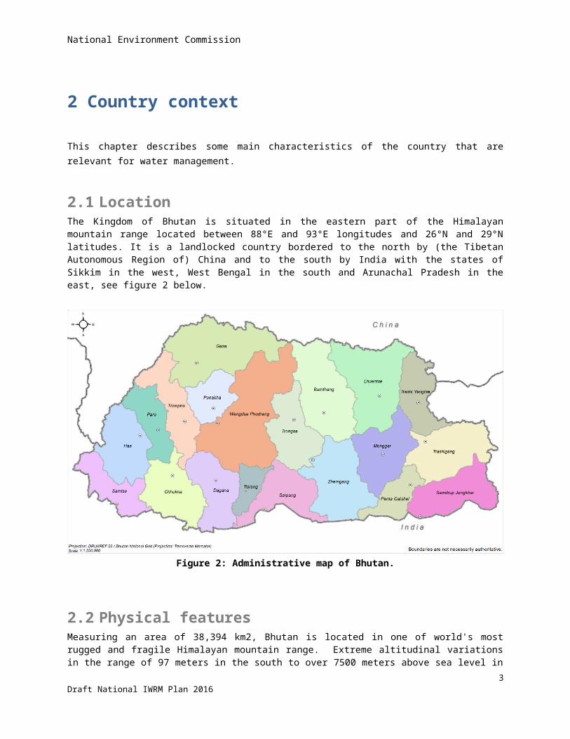
2.1 LocationThe Kingdom of Bhutan is situated in the eastern part of the Himalayan mountain range located between 88°E and 93°E longitudes and 26°N and 29°N latitudes. It is a landlocked country bordered to the north by (the Tibetan Autonomous Region of) China and to the south by India with the states of Sikkim in the west, West Bengal in the south and Arunachal Pradesh in the east, see figure 2 below.
Figure 2: Administrative map of Bhutan.
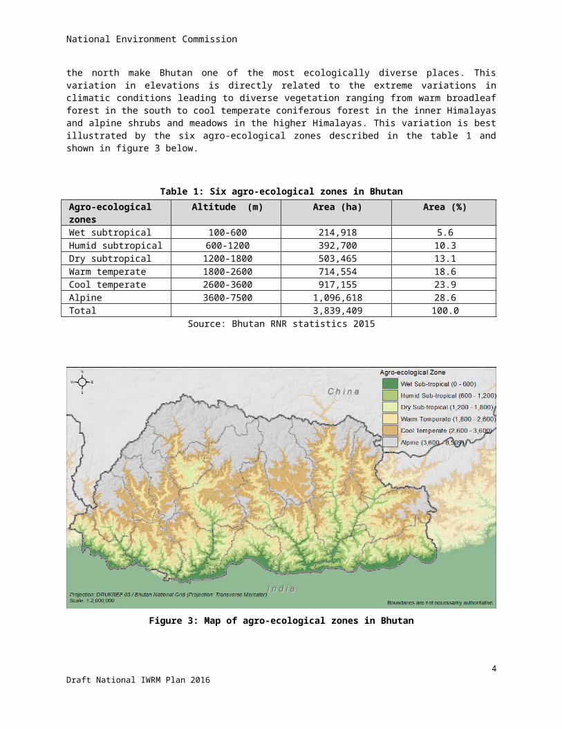
2.2 Physical featuresMeasuring an area of 38,394 km2, Bhutan is located in one of world's most rugged and fragile Himalayan mountain range. Extreme altitudinal variations in the range of 97 meters in the south to over 7500 meters above sea level in the north make Bhutan one of the most ecologically diverse places. This variation in elevations is directly related to the extreme variations in climatic conditions leading to diverse vegetation ranging from warm broadleaf forest in the south to cool temperate coniferous forest in the inner Himalayas and alpine shrubs and meadows in the higher Himalayas. This variation is best illustrated by the six agro-ecological zones described in the table 1 and shown in figure 3 below.
3Draft National IWRM Plan 2016

National Environment Commission
Table 1: Six agro-ecological zones in BhutanAgro-ecological zones Altitude (m) Area (ha) Area (%)Wet subtropical 100-600 214,918 5.6Humid subtropical 600-1200 392,700 10.3Dry subtropical 1200-1800 503,465 13.1Warm temperate 1800-2600 714,554 18.6Cool temperate 2600-3600 917,155 23.9Alpine 3600-7500 1,096,618 28.6Total 3,839,409 100.0
Source: Bhutan RNR statistics 2015
Figure 3: Map of agro-ecological zones in Bhutan
4Draft National IWRM Plan 2016
National Environment Commission
72% of Bhutan is covered with forest, about 7.5% is covered by snow and glaciers and almost 3% are arable land. The rest is covered by water bodies, shrubs, meadows and other land use types. The country is also known for its natural rich water resources with a network of east-west flowing tributaries and major north-south rivers flowing through deep gorges and narrow valleys and ultimately draining into the plains of India and discharging into the Brahmaputra river. Over 90% of the land area has slopes exceeding 25% which promotes runoff and erosion while making access to and management of water resources a costly affair.
2.3 Society and cultureBhutan is a place of social and cultural diversity with local dialects, social norms, local beliefs, and livelihood practices varying across the country. This may be attributed to the high mountains, deep gorges, and fast flowing rivers that have isolated communities. The limited communication and interaction with other communities have led to evolution of livelihoods practices, dialects, religious beliefs, traditions and culture that are unique to the ecological zones. The higher Himalayas are inhabited by nomads that are dependent on livestock and dairy products. Those living along the mountain slopes practice dryland agriculture depending primarily on wheat, barley, maize and horticulture. Some communities practice terraced rain-fed as well as irrigated paddy cultivation. The fertile valleys of inner Himalayas and southern foothills are inhabited by communities that are dependent on paddy and horticultural production. Such livelihood practices are still prevalent in the rural communities that make-up an estimated 69% of the country's population8. Day to day livelihood practices still revolve around subsistence farming and dependence on local natural resources and environmental services especially water supply and forest products.
Majority of the population practice Buddhism followed by smaller section of Hindus and Christians. Buddhist reverence for living beings and beliefs in local deities contribute immensely to preservation and protection of nature and natural resources. Both urban and rural communities pursue strong linkages with ancestral traditions, culture, and religious beliefs that promote respect for nature. Today, Bhutan strongly pursues preservation of these cultural heritages – in which water plays a major role.
Bhutan is a welfare state with free education, health services and agricultural subsidies. The population is expected to grow from 745,000 to some 886,500 by 20309.Though the average registered household size is about 4.6, most of the family members explore livelihood opportunities in urban areas. About 30% of the population resides in urban areas and is expected to reach 50% by 2020. Some 13% of the population lives in Thimphu town alone. Given the difficulties of farming on the mountain slopes, more of the educated younger generation migrate to urban areas in search of employment leaving behind the older members of the family. The resulting decline in agriculture work force has translated into rapid urbanization, unemployment and associated social issues. Half of the population is under 22 years old. The Child (under 5yrs old) Mortality Rate is 6.16%.
2.4 Economy Bhutan’s economy is based primarily on agriculture and forestry, providing livelihood for about 69% of its population. Agriculture mainly consists of subsistence farming and animal husbandry.
The country has embarked on increasing investments in hydropower development for export to India. With over 2000 MW of hydropower generation capacity and another few thousand megawatts of hydro-power under
8 According to National Statistical Bureau, Bhutan's population was 745,153 in 20149 Statistical yearbook of Bhutan, 2014
5Draft National IWRM Plan 2016
National Environment Commission
construction, the country's economy is commonly regarded as hydropower driven. High value low impact tourism is also a major source of foreign currency earnings. Industries are mainly small scale cottage based, but there are breweries, mines, and a chip board industry.
The GDP per capita in 2013 was Nu 142,983.67 (US dollars 2300)10. The average economic growth over the last five years (2009-2013) was 6.7%, but slowed down to 2.07% in the last year, mainly due to negative growth in manufacturing, services and construction. Conversely the positive growth in hotels & restaurants; electricity & water supply; trade; and business services accounted for the net growth of the GDP. (In dollars the GDP declined by 2.31% to USD 1,781.5 million, or USD 2,440 per capita.) The World Bank has classified Bhutan as a lower middle-income country. The share in GDP for key sub-sectors related to water is given in table 2 below.
Table 2: Share of sub-sectors in GDPSub-sector % share in GDP
Agriculture 9.18Livestock 4.11Forestry (& logging) 2.89Water supply 0.03Electricity 14.15Manufacturing 8.51
Source: National Accounts Statistics
Through the bilateral India-Bhutan hydropower cooperation agreement, most of the hydropower investments come from India made available in the mixed grant-loan mode11. With India, the country's foreign debt for hydropower has crossed the value of its GDP. Hydro-power-driven economic development, urbanization, and lack of investment in agriculture have made Bhutan dependent on cereal imports. Improving the food self-sufficiency through agricultural development and irrigation is a key objective of the Royal Government of Bhutan (RGOB) related to water.
2.5 Governance systemThe Governance of the kingdom of Bhutan is a Democratic Constitutional Monarchy as enshrined under Article 1(2) of the Constitution of the Kingdom of Bhutan. His Majesty the Druk Gyalpo is the Head of the State. The executive power is vested in the Lhengye Zhungtshog which consists of ministers headed by the Prime Minister. The legislative power is vested in the parliament which consists of the Druk Gyalpo, the National Council (upper house) and the National Assembly (lower house).
The Royal Government of Bhutan has 10 ministries which work in bringing the goal of Gross National Happiness closer to reality. The Ten Ministries are:
MOA : Ministry of Agriculture MOEA : Ministry of Economic Affairs MOE : Ministry of Education MOF : Ministry of Finance
10 National Accounts Statistics of 201411 Under the India Bhutan Hydropower cooperation arrangements, the grant loan proportion was 40% grant and 30% loan with 10% annual interest rate. The grant-local proportion has been revised to 30% grant and 70% loan at 10% annual interest rate.
6Draft National IWRM Plan 2016

National Environment Commission
MOFA : Ministry of Foreign Affairs MOH : Ministry of Health MOHCA : Ministry of Home and Cultural Affairs MOIC : Ministry of Information and Communications MOLHR : Ministry of Labour and Human Resources MOWHS : Ministry of Works and Human Settlement
Under the Cabinet there is –among other- the Gross National Happiness Commission for planning, and the National Environment Commission as a regulatory body. Both have their own Secretariat. The ministries have representation in the districts.
Bhutan is divided in 20 districts (Dzongkhag); Bumthang, Chukha, Dagana, Gasa, Ha, Lhuentse, Monggar, Paro, Pema Gatshel, Punakha, Samdrup Jongkhar, Samtse, Sarpang, Thimphu, Trashigang, Trashiyangtse, Trongsa, Tsirang, Wangdue Phodrang, and Zhemgang. The districts are sub-divided into Gewogs, the smallest administrative units of which there are in total 205.
A brief description of the role of functionaries of local government is given in table 3 below.
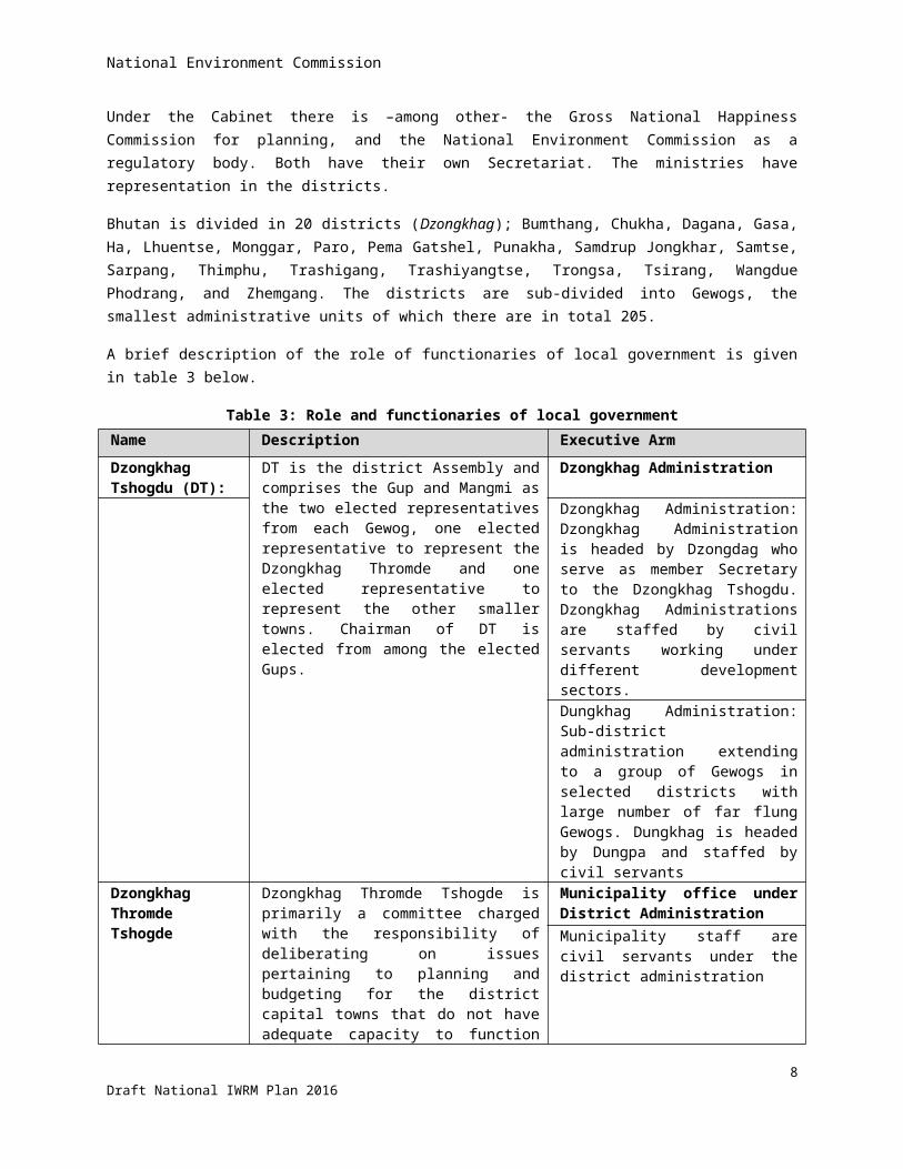
Table 3: Role and functionaries of local governmentName Description Executive Arm
Dzongkhag Tshogdu (DT):
DT is the district Assembly and comprises the Gup and Mangmi as the two elected representatives from each Gewog, one elected representative to represent the Dzongkhag Thromde and one elected representative to represent the other smaller towns. Chairman of DT is elected from among the elected Gups.
Dzongkhag Administration
Dzongkhag Administration: Dzongkhag Administration is headed by Dzongdag who serve as member Secretary to the Dzongkhag Tshogdu. Dzongkhag Administrations are staffed by civil servants working under different development sectors.
Dungkhag Administration: Sub-district administration extending to a group of Gewogs in selected districts with large number of far flung Gewogs. Dungkhag is headed by Dungpa and staffed by civil servants
Dzongkhag Thromde Tshogde
Dzongkhag Thromde Tshogde is primarily a committee charged with the responsibility of deliberating on issues pertaining to planning and budgeting for the district capital towns that do not have adequate capacity to function independently.
Municipality office under District Administration
Municipality staff are civil servants under the district administration
Gewog Tshogde Gewog Tshogde is Gewog Development Committee comprised of elected Gup as Chairman and members comprising of Mangmi and Tshogpa (representatives) elected by basic electoral constituencies called Chiwogs i.e., a cluster of villages.
Gewog Administration
Gewog Administration is headed by the elected Gup. The Gewog Administration is staffed by Gewog Administrative Officer.
7Draft National IWRM Plan 2016
National Environment Commission
Name Description Executive Arm
Gyelyong Thromde Tshogdu
Thromde Office
Gyelyong Thromde Tshogdu is the Executive Council for larger urban area (categorized as Class A Thromde) within a district. It is comprised of elected members of the constituencies and an overall elected Mayor known as Thrompon as the Chairman.
Thromde Office commonly termed as 'City Corporation' headed by the elected Mayor and supported by an Executive Secretary with full-fledged independent administrative and program operations. The Thromde Administration is staffed by civil servants and contract employees.
2.6 Hydrological context
Main and minor rivers
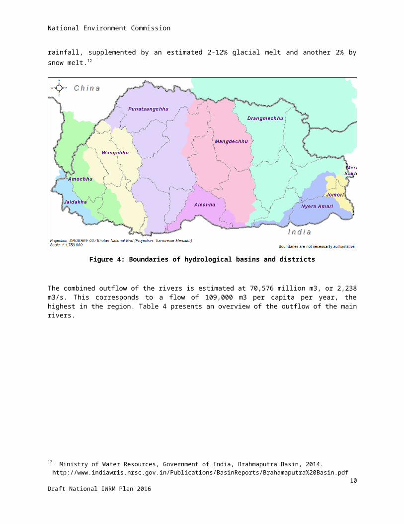
Bhutan has an extensive river system that is generally distinguished in main channels flowing north to south with tributaries flowing is east-westerly direction. They are Amochhu; Wangchhu; Punatsangchhu; and Manas. The latter covers about half the country and is made-up of Mangdechhu; and Drangmechhu that are converging just before crossing the Indian border as one channel. Therefore, Mangdechhu and Drangmechhu shall be considered as two separate basins, see figure 4 below. As can be seen, Amochhu and Drangmechhu originate in China.There are smaller rivers, to mention: Jaldakha, Aiechhu, Nyere-Amari, Jomari/Dhansari, and Merak-Sakteng. Most of the river discharge is fed by rainfall, supplemented by an estimated 2-12% glacial melt and another 2% by snow melt.12
12 Ministry of Water Resources, Government of India, Brahmaputra Basin, 2014. http://www.indiawris.nrsc.gov.in/Publications/BasinReports/Brahamaputra%20Basin.pdf
8Draft National IWRM Plan 2016
National Environment Commission
Figure 4: Boundaries of hydrological basins and districts
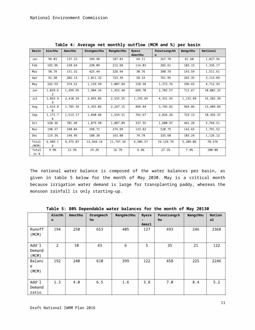
The combined outflow of the rivers is estimated at 70,576 million m3, or 2,238 m3/s. This corresponds to a flow of 109,000 m3 per capita per year, the highest in the region. Table 4 presents an overview of the outflow of the main rivers.
9Draft National IWRM Plan 2016
National Environment Commission
Table 4: Average net monthly outflow (MCM and %) per basinBasin Aiechhu Amochhu Drangmechhu Mangdechhu Nyera
AmachhuPunatsangchhu Wangchhu National
Jan 99.03 137.23 189.98 187.83 64.11 267.78 81.60 1,027.56
Feb 183.96 210.64 230.09 212.68 114.03 282.61 102.15 1,336.17
Mar 50.78 151.32 425.44 328.94 30.76 380.78 143.59 1,511.61
Apr 92.30 202.13 1,011.32 723.39 58.24 761.95 265.35 3,114.69
May 242.59 374.52 1,159.99 1,007.84 158.58 1,372.76 396.65 4,712.93
Jun 1,039.62 1,499.95 1,904.34 1,453.48 689.70 2,702.57 712.67 10,002.32
Jul 1,863.99 2,410.29 2,893.05 2,555.55 1,195.69 4,331.93 1,131.89 16,382.39
Aug 1,414.80 1,785.34 2,355.02 2,247.15 896.84 3,745.82 964.86 13,409.84
Sep 1,171.78 1,513.17 1,840.86 1,554.51 762.67 2,826.26 723.13 10,392.37
Oct 520.36 701.48 1,079.98 1,087.09 337.35 1,600.97 441.28 5,768.51
Nov 190.57 240.04 298.71 274.99 123.82 520.75 142.65 1,791.52
Dec 119.36 148.96 180.38 163.80 74.78 335.60 103.24 1,126.12
Total (MCM)
6,989.14 9,375.07 13,569.14 11,797.24 4,506.57 19,129.79 5,209.06 70,576
Total in %
9.9% 13.3% 19.2% 16.7% 6.4% 27.1% 7.4% 100.0%
The national water balance is composed of the water balances per basin, as given in table 5 below for the month of May 2030. May is a critical month because irrigation water demand is large for transplanting paddy, whereas the monsoon rainfall is only starting-up.
Table 5: 80% Dependable water balances for the month of May 20130Aiechhu Amochhu Drangmechhu Mangdechhu Nyere-
AmariPunatsangchhu Wangchhu National
Runoff (MCM)
194 250 653 405 127 493 246 2368
Add’l Demand(MCM)
2 10 43 6 5 35 21 122
Balance(MCM)
192 240 610 399 122 458 225 2246
Add’l Demand ratio (%)
1.3 4.0 6.5 1.6 3.8 7.0 8.4 5.2
As can be seen from table 5, the additional total water demand in 2030 takes only a few percent of the 80%-dependable amount of water available, with Wangchhu the highest at 8.4% during the month of May.
10Draft National IWRM Plan 2016
National Environment Commission
Glaciers, snow and ice
According to a recent Landsat satellite images and analysis13, Bhutan had 885 Clean Glaciers, and 50 Debris Covered Glaciers in 2010 covering an area of 642 and 16.1 km2 respectively. This is about 1.6% of Bhutan’s total land area as shown in figure 5 below. It has also been determined that the glaciers range from 7230 MASL to 4050 MASL with 361.6+9.3 km2 in the Punatsangchhu (466 glaciers); 32.8+0.7 km2 in the Wangchhu (58 glaciers); Mangdechhu with 179.7+3.05 km2 (287 glaciers); and 780.6+16.1 km2 in Drangmechhu (124 glaciers). The largest glacier in Bhutan with an area of 36 km2 is 090161E 28125N in the Punatsangchhu basin.
Figure 5: Map showing glaciers in Bhutan
Glaciers are good indicators of climate change as they react to temperature and precipitation changes and provide direct visual evidence (NSIDC). Glaciers change in terms of their thickness, area, and mouth which are directly proportional to the change in the atmosphere around them. Melting glaciers are also important sources of freshwater.
13 Bajracharya et al. 2014. The status and decadal change of glaciers in Bhutan from the 1980s to 2010 based on satellite data. Samjwal Ratna BAJRACHARYA, Sudan Bikash MAHARJAN, and Finu SHRESTHA. Annals of Glaciology 55(66) 2014 doi: 10.3189/2014AoG66A125.
11Draft National IWRM Plan 2016
National Environment Commission
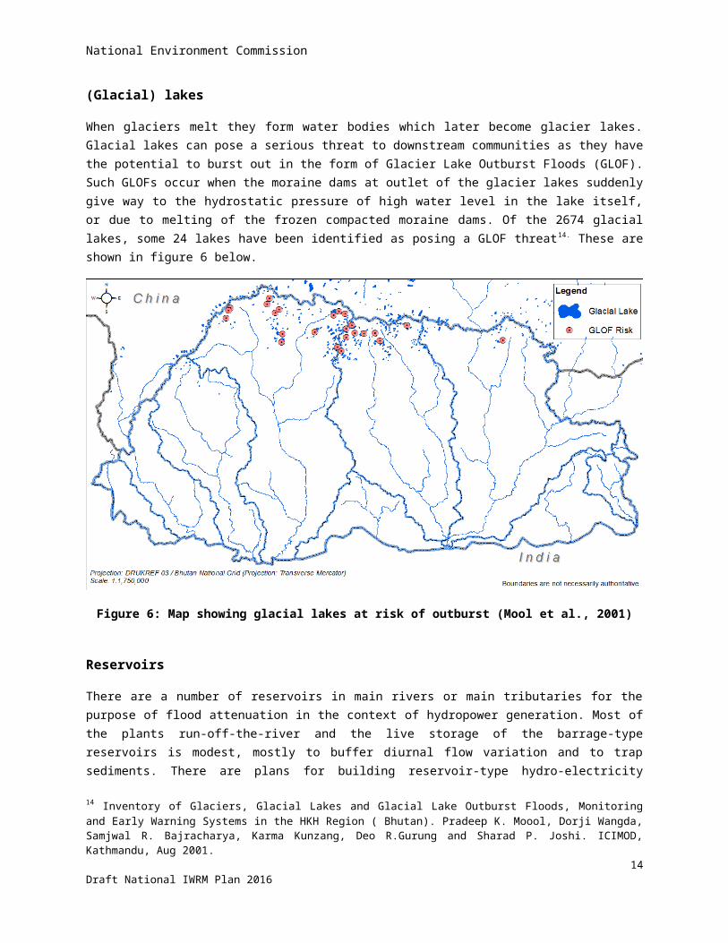
(Glacial) lakes
When glaciers melt they form water bodies which later become glacier lakes. Glacial lakes can pose a serious threat to downstream communities as they have the potential to burst out in the form of Glacier Lake Outburst Floods (GLOF). Such GLOFs occur when the moraine dams at outlet of the glacier lakes suddenly give way to the hydrostatic pressure of high water level in the lake itself, or due to melting of the frozen compacted moraine dams. Of the 2674 glacial lakes, some 24 lakes have been identified as posing a GLOF threat14. These are shown in figure 6 below.
Figure 6: Map showing glacial lakes at risk of outburst (Mool et al., 2001)
Reservoirs
There are a number of reservoirs in main rivers or main tributaries for the purpose of flood attenuation in the context of hydropower generation. Most of the plants run-off-the-river and the live storage of the barrage-type reservoirs is modest, mostly to buffer diurnal flow variation and to trap sediments. There are plans for building reservoir-type hydro-electricity stations in Amochhu, Bunakha and Sankosh. These reservoirs will be large in order to equalize the seasonal variations of the river discharge.
Groundwater
There is very little known about the groundwater in Bhutan. Given the steep terrain and deeply incised valleys, it is generally believed that there is no real groundwater aquifer to mention, although subsurface flow through recent deposits is believed to occur. The somewhat wider and flatter valleys of for example Paro, Punakha, Thimphu and
14 Inventory of Glaciers, Glacial Lakes and Glacial Lake Outburst Floods, Monitoring and Early Warning Systems in the HKH Region ( Bhutan). Pradeep K. Moool, Dorji Wangda, Samjwal R. Bajracharya, Karma Kunzang, Deo R.Gurung and Sharad P. Joshi. ICIMOD, Kathmandu, Aug 2001.
12Draft National IWRM Plan 2016
National Environment Commission
particularly Phuentsholing on the border of the plains in India may well have groundwater reserves that could be exploited. Indeed groundwater is being tapped in these areas in individual cases but the government is generally reluctant to develop the groundwater as a resource as long as the sustainability has not been shown.
Information management system
Relevant hydrological information has been put together in a database and GIS called Bhutan Water Security Information System. It is accessible online through the portal of NEC, and contains the following menu options: (i) Bhutan Water Security Index; (ii) Web-GIS; (iii) Water balances; (iii) Thematic maps.
13Draft National IWRM Plan 2016

National Environment Commission
3 Water-related issues
This chapter gives an overview of seemingly un-related issues. However, they all affect the water resources in their own way. The list is perhaps not exhaustive but supposedly covers the most important issues. Most of them are well known and have not been elaborated for the NIWRMP, such as drinking water supply; glacial lake outburst floods; and landslides. The current approach to these issues is sound and should be continued. Development of irrigated agriculture is addressed separately in the National Irrigation Master Plan, 2016. Other issues have been studied in depth for the NIWRMP, to mention a few: institutional coordination; water availability per district; identification of water-scarce and flood-prone areas. The details can be found in stand-alone supporting documents, the results are briefly summarised to supplement the understanding of the subjects.
3.1 Inadequate coordinationMany different agencies are involved in some way or another in the management of water resources. So far, the approach to management has largely been sector-based, but efforts for better coordination have been made. The Water Policy (2003) and Water Act (2011) and Regulations (2014) pave the way for adopting IWRM. The Water Act of 2011 is explicit in empowering the NEC as the apex body for all matters concerning the water resource of Bhutan. Hence, it has the responsibility of coordinating the efforts of competent authorities and line agencies in managing the water resources of the country.
However, even at the level of NECS, no defined mechanisms exist at present to coordinate and enhance cooperation with water-related agencies and other environmental organizations. The Water Resource Coordination Division (WRCD) of NECS that is charged with the responsibility of implementing the Water Act is presently understaffed with only three officers and a technician. Meanwhile, other water related agencies pursue their own priorities without relating to the other.
Efforts have been made by the government to foster this role through establishment of a water board comprised of director level officials from various agencies. However, the board does not meet regularly and it is not clear how it fits within the overall coordination role and mandated functions of NECS.
These aspects are addressed as priority in chapter 7.
3.2 Water availability is strongly seasonalThe weather in Bhutan is distinctly seasonal, with monsoon rains between April and October. Precipitation does occur in the other months of the year but is very little. Given the rugged terrain, there is a high proportion of runoff into small streams and rivulets. These discharge into tributaries and rivers that are characterised by steep gradients and narrow stream beds that have very little storage. As a result, surface water is quickly evacuated - even from the country. Whatever water is available during the lean winter season is the result of underground base flow – and this is limited. Water stored in lakes in the mountains is beyond reach.
As already stated, Bhutan has enormous amounts of water per capita but the figure is in fact strongly seasonal. It can be stabilised by retaining the water. That can be achieved by conservation of the watershed; maintaining
14Draft National IWRM Plan 2016
National Environment Commission
forest and/or ground cover to intercept rainfall, hold the water and promote infiltration. Erosion gullies, that make the water run down the slopes should be controlled. Water can also be held back artificially, as explained in the following paragraph.
3.3 Multi-purpose reservoirsApart from watershed conservation, water outflow can also be slowed-down artificially in the form of retention structures. Higher on the hill slopes, many small retention structures can store water for domestic use. Lower down the hill slopes, check dams may be somewhat larger and provide water for domestic use and irrigation and perhaps micro-hydropower generation. Large reservoirs could be built in the tributaries and/or main rivers, but there water is not scarce. Such reservoirs could level-out the strongly seasonal flow fluctuations for generation of hydropower, but would have little use for domestic use and agriculture15.
Various sites have been identified for small hydropower stations16, and other sites have later been identified for micro hydropower stations17.
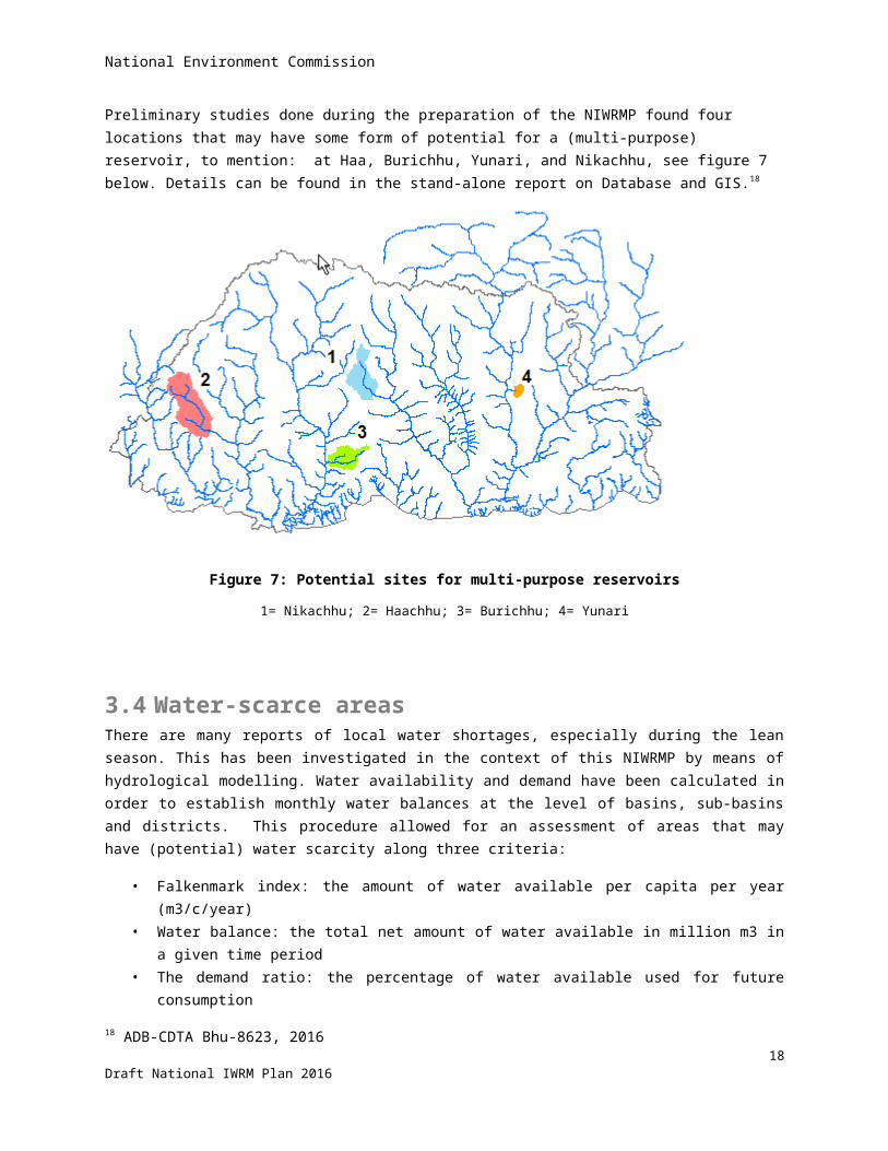
Preliminary studies done during the preparation of the NIWRMP found four locations that may have some form of potential for a (multi-purpose) reservoir, to mention: at Haa, Burichhu, Yunari, and Nikachhu, see figure 7 below. Details can be found in the stand-alone report on Database and GIS.18
Figure 7: Potential sites for multi-purpose reservoirs
1= Nikachhu; 2= Haachhu; 3= Burichhu; 4= Yunari
15 Unlike Nepal, Bhutan does not have a Terrai – large areas that could be irrigated with river water regulated by reservoirs.16 Power Systems Master Plan, MoEA, RGOB, 200317 Data collection survey on renewable energy in the Kingdom of Bhutan, JICA-DRE MoEA, 201318 ADB-CDTA Bhu-8623, 2016
15Draft National IWRM Plan 2016
National Environment Commission
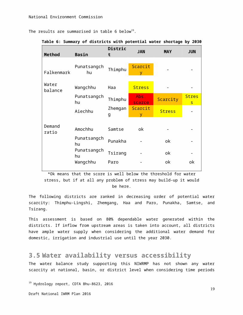
3.4 Water-scarce areasThere are many reports of local water shortages, especially during the lean season. This has been investigated in the context of this NIWRMP by means of hydrological modelling. Water availability and demand have been calculated in order to establish monthly water balances at the level of basins, sub-basins and districts. This procedure allowed for an assessment of areas that may have (potential) water scarcity along three criteria:
• Falkenmark index: the amount of water available per capita per year (m3/c/year)• Water balance: the total net amount of water available in million m3 in a given time period• The demand ratio: the percentage of water available used for future consumption
The results are summarised in table 6 below19.
Table 6: Summary of districts with potential water shortage by 2030
Method Basin District JAN MAY JUN Falkenmark Punatsangchhu Thimphu Scarcity - - Water balance Wangchhu Haa Stress - - Punatsangchhu Thimphu Abs. scarce Scarcity Stress Aiechhu Zhemgang Scarcity Stress - Demand ratio Amochhu Samtse ok - - Punatsangchhu Punakha - ok - Punatsangchhu Tsirang - ok - Wangchhu Paro - ok ok *Ok means that the score is well below the threshold for water stress, but if at all any problem of
stress may build-up it would be here.
The following districts are ranked in decreasing order of potential water scarcity: Thimphu-Lingshi, Zhemgang, Haa and Paro, Punakha, Samtse, and Tsirang.
This assessment is based on 80% dependable water generated within the districts. If inflow from upstream areas is taken into account, all districts have ample water supply when considering the additional water demand for domestic, irrigation and industrial use until the year 2030.
3.5 Water availability versus accessibilityThe water balance study supporting this NIWRMP has not shown any water scarcity at national, basin, or district level when considering time periods of one month. But this does not exclude the possibility that within the districts there can still be areas with temporary water shortage. For example, some housing blocks in Thimphu city located near the perennial Thimphu river have piped water supply that is operational only for a few hours every other day. This shows that the occupants of the housing block have limited access to water although the river is flowing past in their vicinity.
19 Hydrology report, CDTA Bhu-8623, 2016
16Draft National IWRM Plan 2016

National Environment Commission
Likewise there are many irrigated fields that (temporarily) lack water supply from the local source along the hill slope when large volumes run down the stream at some distance. This aspect is depicted in figure 8 below.
The examples show three aspects:
i. The hydrological modelling has limits with regards to zooming-in. District-level water balances are technically feasible, but they have little relevance at household or farm level.
ii. Water may be available but not accessible, without investment in equipment (storage reservoirs, pumps) and operation (diesel or electricity cost of pumping, maintenance). It is not a problem of water shortage, but a problem of water management. This aspect is compounded by the low-density of the population living highly dispersed on the hill slopes.
iii. Managing the water at micro scale cannot be done from the centre and can best be done at the local level. This is particularly the case in Bhutan because of its large local variations in elevation and aspect of the terrain.
Figure 8: Schematic presentation of water availability
3.6 Demand managementWhen confronted with (potential) water scarcity, one often looks at supply-side solutions like augmenting the water supply or accessibility in the form of putting-up retention reservoirs, tapping new (remote) water sources or groundwater, etc.
However, one may also try to contain or reduce the demand for water in order to reduce the water stress. Examples of demand management measures can be grouped in two categories.
Higher agricultural productivity17
Draft National IWRM Plan 2016

National Environment Commission
Timely land preparation (power tillers) and transplantation of paddy Different crops and varieties (short season, HYV, resistant to pest/ disease) System of Rice Intensification Drainage of excess (rain) water Reduce pre/ post-harvest losses Integrated Pest Management
Higher water use efficiency
Use of mulch or plastic sheet to reduce evaporation Better irrigation scheduling to prevent over-irrigation Better puddling of paddy fields to reduce seepage losses Piped/ lined supply channels to reduce conveyance losses Replace surface (basin or furrow) irrigation with sprinklers or drip systems Trashing/ mixing plant residues in soil to improve water-holding capacity Water pricing
3.7 Water as common pool resourceWater is used by everybody to meet personal ends, but it is also used in many ways for economic purposes, such as irrigation, hydropower generation, commercial car wash, chip-board industry, water bottling, etc. With everybody having access to water, this can lead to competition. As such, water is a common pool resource. Everyone who utilizes a common pool resource is inherently dependent on everyone else who has access to that same resource. Individuals tend to maximize their own returns rather than work towards collective outcomes – sometimes referred to as “tragedy of the commons”. However, properly designed collective action systems have successfully managed common pool resources for hundreds of years. Examples are: traditional rainwater harvesting structures in Rajasthan, or common grazing areas in dry parts of Africa. At local level in Bhutan, Water Users Associations can play an important role in managing water resources as a common pool resource.
3.8 Areas prone to monsoon floodsIn the context of this NIWRMP, it has been investigated which areas may be prone to monsoon flooding. The results are shown in figure 9 below20. The red areas are prone to flooding, and the figure gives the surface area in hectares.
20 The justification can be found in the stand-alone supporting document “Hydrological modeling and water resources assessment,Bhu-8623, 2016.
18Draft National IWRM Plan 2016
National Environment Commission
Figure 9: Map of areas prone to monsoon flooding
3.9 Glacial Lake Outburst FloodsGlacial lakes are classified according to the risk of outburst described in section 2.6. A zonation is done in downstream areas, distinguishing zones of high or low risk of flood damage in case of outburst. Settlements and economic development should stay out of harm’s way.
3.10 Drinking water supplyThe most important use of water resources is for drinking water, and it has been given the highest priority in the Water Act. Drinking water is usually tapped from wells and small rivulets on the hill slopes upstream of the dwelling areas. These sources are not always reliable and therefore alternative sources are often being sought at relatively great expense. Drinking water for larger cities is also abstracted from perennial streams where the supply is more secure throughout the year.
3.11 Agricultural water useAgriculture is the biggest consumer of water by way of irrigation. Most fields are fragmented and scattered along the hill slopes, where water is tapped from springs and rivulets. Local and/or temporary shortages of irrigation water occur frequently and tapping alternative sources is generally expensive because of the topography. There are some larger irrigation schemes in the southern foothills. The National Irrigation Master Plan has recently been elaborated in order to increase food production and self-sufficiency21. The impact of increase irrigation water demand is addressed in section 3.13.
21 National Irrigation Master Plan, ADB CDTA project Bhu-8623, 2016
19Draft National IWRM Plan 2016
National Environment Commission
3.12 Hydropower generation
Hydropower development plans
At present, Bhutan has only developed some 1,500 MW out of the economically feasible 24,000 MW of hydropower. The 10th FYP showed the intension of developing hydropower potential as given in figure 10 and table 7 and figure 11 below.
Figure 10: Map showing location of existing and planned hydropower stations
20Draft National IWRM Plan 2016
National Environment Commission
Table 7: Hydropower projects scheduled for construction in the 10th & 11th FYP periodsNr. Project name Capacity (MW) Construction period1 Punatsangchhu-1 1200 2008-20152 Mangdechhu 720 2009-20163 Punatsangchhu-2 1000 2009-20164 Bunakha reservoir 180 2010-20165 Wangchhu reservoir 900 2010-20176 Chamkharchhu-1 670 2011-20177 Kholongchhu 486 2011-20178 Amochhu reservoir 620 2012-20189 Kuri-Gongri 1800 2012-2019
10 Sankosh reservoir 4000 2011-2020
The planned hydropower development is graphically presented in figure 10 below.
2015
Punatsan
gchhu 1
Mangd
echhu
Punatsan
gchhu 2
Bunakha r
eservo
ir
Wan
gchhu re
servo
ir
Chamkh
archhu 1
Kholongchhu
Amochhu re
servo
ir
Kuri-Gongri
Sanko
sh re
servo
ir2020
0
2000
4000
6000
8000
10000
12000
14000
Planned hydropower development 2015-2020
MW
Figure 11: Planned hydropower development until 2020.
The 11th FYP became more modest and aims to triple the installed capacity to 4,500 MW by 2018.
Currently, construction of 1,020 MW Punatsangchhu I Hydroelectric Project, 1,000 MW Punatsangchhu II and 720 MW Mangdechhu Hydroelectric Projects are on-going. All three projects are scheduled to be completed by 2017-18. The other projects, to achieve 10,000 MW hydroelectricity generations by 2020, are planned to start construction during the current Plan period. The construction period ranges from 8-9 years. The pipeline projects are listed in table 8 below.
21Draft National IWRM Plan 2016

National Environment Commission
Table 8: Pipeline hydropower projects according to the 11th FYPNr. Project Capacity (MW/ GWh)1 Sankosh 2560/ 62162 Amochhu 540/ 18353 Kuri-Gongri 2640/ 100564 Chamkharchhu-1 770/ 32495 Bunakha 180/ 16696 Wangchhu 570/ 25267 Kolongchhu 600/ 2599
In addition, small hydro-projects shall deliver some 8,000 KW22.
The EIA reports related to planned hydropower plants refer to a bilateral agreement between RGOB and India signed in 2009, whereby India would buy 10,000 MW by the year 2020. Where most of the hydropower stations in Bhutan are run-off-the-river type, some of the planned stations are reservoir type so as to flatten the hydrograph and to make more efficient use of the generators. The changes in downstream water flows are not expected to have an impact on drinking water supply or irrigation. But large dams and reservoirs may cause loss of agricultural land due to inundation. Environmental Impact Assessments treat this aspect of loss of arable land as loss of income to farming families, for which compensation is proposed. Hence, the loss of farm land is not put in the context of RGOB’s policy objective of achieving food self-sufficiency.
Water use is non-consumptive
Hydropower makes use of a very large amount (and percentage) of the fresh water resources in Bhutan, but it is not consumptive use. Hence, the water use by hydropower does not appear in the water balances supporting this report.
Environmental impacts
The impact of hydropower on environment is addressed in all Environmental Impact Assessment reports that are prepared before construction of the plants. For the run-off-the-river systems the impacts are local and relate mainly to land acquisition and temporary disturbance caused by construction works. Remedial measures for negative impacts have been proposed, but their implementation is not closely monitored. Moreover, the cumulative impacts of hydropower plants are not being studied.
Environmental flow
The Water Act and Regulation prescribe that environmental flow shall be maintained in the river sections that are by-passed by the head and tail race tunnel of the hydropower plants. This environmental flow shall be 30% of the lean period flow – unless otherwise has been proposed and approved in the Environmental Impact Assessment or other study. Indeed the various EIAs apply different methodologies for assessing the environmental flow. Enforcement of environmental flows is weak. A project has recently started a study into environmental flow.
22 11th FYP
22Draft National IWRM Plan 2016
National Environment Commission
Debt servicing
Bhutan’s public and publicly guaranteed external debt stood at 99 percent of GDP by end-June 2015, two thirds of which are related to commercially profitable hydropower projects23. This debt will increase with further development of the hydropower sector. Only on the longer run, when these hydropower projects become operational and revenues are generated, Bhutan’s debt carrying capacity will improve.
Competition for land
Hydropower generation is often equated with big dams, and resettlement of communities. In Bhutan however, all the power plants are so-called run-off-the-river systems. They divert water locally from the river so no storage reservoir is involved (only a barrage) and no land is lost to inundation. Thus, run-off-the-river systems cause minimum environmental damage. The disadvantage is that power generation fluctuates with the strongly seasonal flow in the river.
There are plans to build hydropower stations in future (such as Amochhu, Bunakha, and Sankosh) that do involve storage reservoirs to optimize and stabilise the electricity production. In those cases land is lost to inundation, but nearly all of that is forest land. Settlements and agricultural fields are not located in the river gorges and are therefore not affected. (There may be few exceptions but affected people are relocated and compensated).
3.13 Competition for waterPotential competition between irrigation water demand and hydropower generation has been investigated.
Hydropower generation takes place in the main rivers or main tributaries. Water is only used to drive the turbines and then flows back to the river, so hydropower generation does not actually consume water. By contrast, irrigated agriculture does consume water (lost to evapotranspiration) that is generally tapped from the higher order tributaries – hence upstream of the hydropower plants. Therefore irrigation water demand affects hydropower, but not the other way round.
The self-sufficiency for paddy is presently in the order of 50%. The amount of water needed to achieve full paddy self-sufficiency has been estimated and compared with the amounts of water available in the basin. The figures are presented in table 9 below for the month of May – when irrigation water supply is critically high and monsoon rains are just starting-up. The percentage of water used in other months is (much) lower.
Table 9: Percentage of available water used to increase paddy production to full self-sufficiency by 2030 for the month of MayBasin Amochhu Wangchhu Punatsangchhu Mangdechhu Drangmechhu% water used 4% 16% 13% 3% 9%
Thus, the percentage of basin water used for self-sufficiency level paddy cultivation represents the reduction of water available for hydropower generation.
23 World Bank MPO-October 2015
23Draft National IWRM Plan 2016
National Environment Commission
One has to bear in mind the following aspects:
The peak hydropower production will unlikely be affected by increased paddy production because in the months of July-August rainfall will largely satisfy the crop water demand (hence little or no irrigation water demand), and there is already more discharge in the river than used by the hydropower plants.
Increased rainfall resulting from climate change may (partially) compensate for the reduction of water available for hydropower generation.
More-efficient irrigation methods will reduce the demand for irrigation water and leave more water for hydropower generation.
3.14 Impact of climate changeThe impact of climate change on future rainfall has been assessed during preparation of the NIWRMP24 and shows an increasing trend, as shown in figure 12 below for RCP 4.5 (reduction in emission)25
Figure 12: Long-term rainfall projections for Bhutan
24 CDTA report on Hydro-meteorological projections for Bhutan based on CMIP5 scenarios, Bhu-8623, 201625 Representative Concentration Pathways (RCPs), were developed by the IPCC and are identified by their total radiative forcing, measured in watts per square meter (W/m2) in year 2100 relative to 1750. Radiative forcing is defined as the difference of the solar energy absorbed by the Earth and the energy radiated back to space. Essentially, these scenarios describe the degree in which greenhouse gas emissions are actively mitigated, stabilized, or increased.
24Draft National IWRM Plan 2016
National Environment Commission
The spatial variation of rainfall is presented for RCP 4.5 in figure 13 below.
Figure 13: Projected change in precipitation for RCP 4.5
As can be seen, the precipitation is projected to increase, particularly in the south of the country and during the monsoon period – when water is already in ample supply. This will increase the runoff, as well as discharge and sediment load in the rivers during summer. The sediments will settle along the river when the flow rate reduces towards the lean season, which may increase the flood hazards during the next monsoon. Higher variability and uncertainty are also expected. There would be more chance of extremely high river discharge during the wet season, calling for new design procedures for water works. The traditional approach of design floods based on observed return-periods would grossly under-estimate the river discharge and levels, as shown in figure 14 below.
As can be seen, the flow for a return period of 50 years may increase by 2045 around 26% in Wangchhu; 7% in Punatsangchhu; and up to 38% in Mangdechhu and Drangmechhu.
25Draft National IWRM Plan 2016
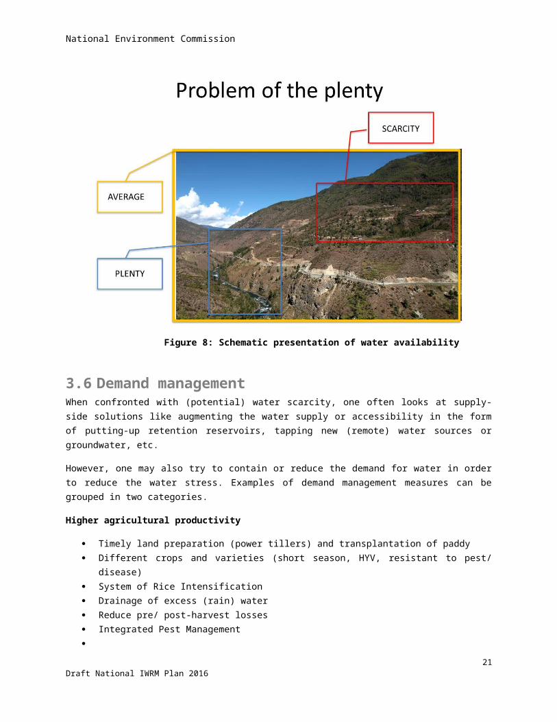
National Environment Commission
Wangchhu
Flow increase 50 year return period till 2045 = 26%Punatsangchhu
Flow increase 50 year return period till 2045 = 7%Mangdechhu
Flow increase 50 year return period till 2045 = 38%Drangmechhu
Flow increase 50 year return period till 2045 = 38%
Figure 14: Basin outflows and their return periods
26Draft National IWRM Plan 2016
National Environment Commission
Besides, a trend is expected towards lesser river flow in winter, but no change in minimum flows.
However, the climate change assessments are constrained by dearth of data with limited spatial representation and often covering less than the minimum requirement of thirty years of observations. Hence, the projections become less realistic when zooming-in into smaller areas such as districts and Gewogs.
The temperature is also expected to rise, and more so in the north of the country. This has an impact on river discharge by increased snow and glacial melt. The temperature and its change over time are presented for RCP 4.5 in figure 15 below. The increase in temperature will also increase forest and crop water demand by increased evapotranspiration.
Figure 15: Projected changes in temperature for RCP 4.5
3.15 Water sources drying-upThere are frequent reports of water sources drying-up. This appears to be at odd with predictions of increased rainfall caused by climate change. Studies have found that rainfall has in fact declined over the last two decades in a number of stations spread over the country – without discernible spatial trend, see figure 16 below 26. Plotting rainfall figures over longer time periods conceals this observation, and shows an increasing trend, as seen in figure 12 above. This shows how delicate it is to draw conclusions in relation to climate and climate change!
26 ADB-CDTA Bhu-8623 report: Hydrological modeling and water resources assessment, 2016
27Draft National IWRM Plan 2016
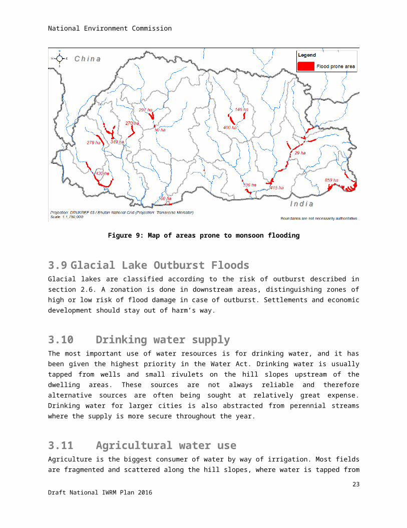
National Environment Commission
1995 2000 2005 2010 20150
2000
4000
6000
8000
Rainfall trend in Amochhu basin
Chukha Linear (Chukha)Samtse Linear (Samtse)
year
mm
1995 2000 2005 2010 20150
2000
4000
6000
8000
Rainfall trend in Wangchhu basin
Haa ChukhaLinear (Chukha) ParoThimphu
year
mm
1995 2000 2005 2010 20150
1000
2000
3000
4000
5000
Rainfall trend in Punatsangchhu basin
Dagana Linear (Dagana)Tsirang Linear (Tsirang)Gasa Linear (Gasa)
year
mm
1995 2000 2005 2010 20150
5001000150020002500
Rainfall trend in Mangdechhu basin
Bumthang Linear (Bumthang)Trongsa Linear (Trongsa)Zhemgang Linear (Zhemgang)
year
mm
1995 2000 2005 2010 20150
50010001500200025003000
Rainfall trend in Drangmechhu basin
T-Yangtse Linear (T-Yangtse)T'gang Linear (T'gang)Mongar Linear (Mongar)Pema-G Linear (Pema-G)
year
mm
Figure 16: Recent rainfall trends in different basins
28Draft National IWRM Plan 2016

National Environment Commission
3.16 Pollution and water qualityWater quality is believed to be generally very good in Bhutan, especially in upstream areas and away from population pressure. But there is increasing concern that population growth, burial customs, and fast urbanisation outpace the installation of sewerage treatment and solid waste collection, and is thus threatening the water quality.
Deforestation and land degradation from over-grazing tend to enhance soil erosion and increase the sediment load in the rivers during high waters. High sediment loads in the water are detrimental to the turbines in hydropower plants and pose a high demand on management.. Besides, many small piped water systems for domestic water supply get blocked by sediments during the monsoon period.
Water quality is being monitored, but measurements are ad-hoc. Water quality standards are not yet in place for ambient water or effluent water.
3.17 Loss of agricultural landAgricultural land has been under pressure with increasing population, economic development and urbanization. From the Statistical Yearbooks, it was reconstructed that the area of paddy land has decreased from 62,360 acres in 2006 to 48,361 acres in 2013, or 23%! The area planted to maize was reduced from 75,800 acres in 2005 to 58,338 acres in 2013, or 25%. The area under wheat reduced from 21,900 acres in 2005 to 5,560 acres in 2010, or 75 % decline!27 Such decrease in arable area puts food self-sufficiency in jeopardy.
3.18 LandslidesLandslides are a common feature in Bhutan, especially during the rainy season. The number of incidences has increased with the construction of (farm) roads due to steep cuts into the hill sides and weight of spoil on the downslopes. The areas that are most prone to rainfall induced failures are heavily fractured and weathered rocks of phyllites, slates and schists that contain high amounts of clay minerals that occur in the southern part of Lesser Himalayas28.
The Department of Geology and Mines has been involved in preparing hazard maps along some of the existing highways and important sites of new towns. The Department of Road has re-aligned some roads on the basis of these hazard maps, or applied environmental friendly road construction. This method applies flatter cuts into the hill sides (resulting in more-stable slopes), provides better drainage and removes spoil, but is very expensive.
Different geological settings cause different types of landslides calling for different mitigating measures, like avoidance; stabilization, prevention or no action (live with recurring maintenance from landslide). Some of the common strategies to stabilize, control or prevent landslides include (sub-) surface drainage, retaining walls, soil reinforced earth and bioengineering of the disturbed slopes.
27 From NIMP, Bhu-8623, 201628 Rapid classification of watersheds in the Wangchhu basin, SNV-WMD, DOFPS, MOAF, 2011
29Draft National IWRM Plan 2016

National Environment Commission
3.19 Over-grazing Most of the pasture grasses are perennial, with root rhizome growth in the top 6” to 9” layer of the soil. These grasses bind the soil particles and make a good ground cover by their spreading habit and thus reduce soil erosion from wind and water. There is little registered pasture land and cattle are allowed to graze freely in forest areas. Repeated browsing, nibbling, and uprooting of saplings and trampling of the soil hinders natural regeneration, especially when the same areas are grazed twice - by yak in winter and by cows during the summer.
3.20 Forest firesForest fire is one of the prominent causes of forest degradation in the country29 thus leading to more runoff. The forest department in the last four years (2010-2014) recorded, an average of 45 forest fire incidences damaging about 19,844 acres of forest annually. Helicopters can effectively be used for fire-fighting, if there are ponds throughout the country for refilling their water containers.
3.21 Shifting cultivationShifting cultivation is does occur in Bhutan, whereby forest land is cleared and temporarily used for cultivation. After a few years, the productivity comes down and farmers shift to another location. In this way, the cultivation rotates over a number of locations. If the rotation cycle is long enough, there is scope for regeneration of the forest on these lands. But, cultivation of the same land in quicker cycles is causing land degradation. The Social Forestry Division estimated that about 883 Km2 is utilized (nationally) for shifting cultivation, mostly on steep slopes.
29 Bhutan RNR statistics 2015
30Draft National IWRM Plan 2016

National Environment Commission
4 Governance framework
Following the water-related issues given in the previous chapter, this chapter describes how the approach to tackling water-related issues has changed over time, and what enabling environment is presently available. It continues with a description of the national planning process followed by a description of the institutional framework and stakeholder analysis. This chapter also looks at tools available for IWRM, a training needs assessment and finally describes an inter-agency coordination framework based on the Bhutan Water Security Index.
4.1 Evolution of approach to water managementApproaches to water resources management and corresponding institutional setup worldwide have evolved over many decades. Early water resource management, which continued up to the 1960s, addressed mainly single-purpose endeavors that pursued an engineering agenda (so-called “hydraulic” missions) linked primarily to dam-building and water engineering works (for flood control, drainage, irrigation and water supply). Technocratic solutions dominated this era of top-down water resource management, and water management entities were principally instruments of the national government.
Beginning in the 1970s, concern about environmental and social impacts, including worsening water quality, paved the way for multi-purpose water resource management that also saw the beginnings of a river basin approach (usually within an “integrated area” development context). Multi-stakeholder participation was introduced. Watershed protection gained prominence, and procedures for environmental impact assessment requirements expanded the scope of water development concerns to include social and ecological aspects. Nonetheless, river basin organizations still pursued mainly water-related concerns with a strong sectoral orientation (i.e., water treated as a separate sector).
In the 1990s, the shift to a sustainable development vision paved the way to adopt a comprehensive system of water resource management, one that emphasized coordinated development and the management of water, land and ecological resources. Importance was also put on holistic approaches that sought to integrate management of water resources within a broader socio-economic and institutional framework. During this period IWRM became the dominant paradigm. It considerably expanded management challenges, for it often requires balancing competing sector needs and establishing governance mechanisms for coordinating various entities involved in water management (and who are not used to such coordination, or resist coordination). The introduction of IWRM also came with sector-wide policy reforms and decentralization of governance, and along with these the challenges of effective coordination. A strong focus was given to the river basin as the logical (hydrological) unit for management, which remains to this day.
Over the past decade, the management scope for water resources has further expanded to include concerns over the impact of climate change. This was to be expected since climate is the main supply driver which ultimately determines how much water is available, and because managing extreme events associated with climate change (droughts and floods) is fundamental to water resource management. Apart from this development, there is increasing acknowledgment that, as with environment, water is not a sector. Rather, that water is part of a nexus involving in particular agriculture, ecology and energy. Drivers of change in the water sector often arise from
31Draft National IWRM Plan 2016
National Environment Commission
activities in these other sectors. This latest evolution of the water management paradigm has put coordination in an even more central role.
In Bhutan, the WRM institutional framework already adopts coordination—embodied in the mandate of the NEC--as the core management principle (in other words, Bhutan is on the “right” track). For the institutional design of IWRM in Bhutan, corresponding emphasis is on enhancing coordination at both the national and river basin level. The following definition of coordination is used to guide the IWRM mission in Bhutan: Coordination is a situation in which policies and programs of government and its agencies are characterized by minimal redundancy, incoherence and gaps.
In addition, the coordination model of WRM in Bhutan should be framed/designed more specifically to address effectiveness and efficiency aims: (i) effective in achieving what? and (ii) efficient in doing what?
4.2 Overview of policies and legal frameworkThe following paragraphs summarize the steps that RGOB has already taken towards adopting IWRM in the national policy documents and the national legal framework. Details are given in a separate document supporting this NIWRMP.
Overview of the Policies
Vision Statement 1999
In 1999 the Planning Commission issued the vision statement for 2020. Part-1 stated that the vast hydropower potential should be developed, yet it emphasized the need for environmental conservation, and warned that the progressive removal of vegetation cover, especially in critical watershed areas, was beginning to affect the hydrological balance, leading to the localized drying up of perennial streams and flash flooding.
It also mentioned the challenge to increase efficiency and to widen the opportunities of the decentralized administrative system. Hence, the people at the Gewog level should have more influence in decision-making that has a direct bearing on their lives and livelihoods and the future of their communities.
Greater priority also needed to be accorded to the development of the information systems required for informed decision making and development planning.
Part-2, which dealt more with goals, objectives, strategies and milestones, emphasized the need for sustainability. It stated that sustainability had many dimensions - social, financial, economic, cultural and environmental - and they were all of critical importance in Bhutan since they all impacted, directly and indirectly, on its sovereignty and security. It distinguished five thematic headings to steer the process of change: human development, culture and heritage, balanced and equitable development, governance, and environmental conservation. One of the milestones mentioned for planning (for 2007) was the preparation of watershed master plans: a prelude to the river basin management plans that are presently foreseen under the Water Act and Regulation
Bhutan Water Policy 2003
In April 2003 the Bhutan Water Partnership issued the Bhutan Water Policy (BWP). The Government approved the document in 2006. The BWP is a reflection of the Royal Government’s commitment to the conservation, development and management of the country’s water resources. It recognized that water is a precious natural
32Draft National IWRM Plan 2016
National Environment Commission
resource and a heritage important to all aspects of social, economic and environmental wellbeing. As a result, the policy recognized that every individual has the right to safe, affordable, and sufficient quantity of water for personal consumption and sanitation.
With regard to uses of water, the BWP stipulated three main principles:
Water is a common good. Its uses are open to all legitimate users under the provision of the water act.
The policy sets priority for all legitimate uses of water. First priority goes to drinking and sanitation, which are essential for human survival. Allocation of water for irrigation, hydropower generation, industrial uses, recreation and other uses are to be guided based on the national and local priorities.
The policy also recognized the importance of water for agriculture and food production. The policy thus emphasized that water allocation to the agriculture sector must be compatible with the objective of national food security.
The BWP adopted the principles of IWRM. It stated that water resources in the country would be managed based on natural river basin. Accordingly, the policy emphasized establishing institutions based on river basins.
Overview of the legal Framework
Water Act 2011 and Water Regulation 2014
The Water Act of Bhutan 2011 (Water Act) is an important milestone in the development of the legal framework regarding the water resources in Bhutan. It is the first act that addresses water resources in an integrated manner. Until then, management of water resources was fragmented, addressed in different laws, and only focused on the operational level.
The Water Act is also an important milestone in the implementation of the concept of IWRM in national legislation. It is also in line with the national concept of Gross National Happiness. Both concepts are expressed in the preamble of the Act and elaborated in broad terms in the various chapters. In brief, the Act has the objective to advance a coherent, integrated and open approach to the different aspects of water resources management in a sustainable way and with the river basin approach as leading principle. To achieve this goal, the Act provides for a number of organizational and substantive facilities. The first aspect concerns the formulation of the distribution of authorities and responsibilities between the various governmental bodies involved in water management. The second aspect is aimed at providing the competent authorities with strategic and operational legal instruments to enable them to perform their tasks properly.
Some notable characteristics of the Water Act are:
- The Act is a true management law. It is not primarily about the development of water infrastructure (including irrigation networks), but about creating conditions for a responsible and sustainable management of the water resources.
- The scope of the Act covers water management in all its aspects: surface water and groundwater, both in quantitative and in qualitative terms; it also concerns the infrastructure dimension: river basins, irrigation systems, dams, water supply systems, etc. In other words, it provides a coherent and integrated approach. The integrated approach is also manifested in the emphasis on the importance of the basin approach. Water systems (river basins and groundwater basins) with their functional relevant environment are the frame of reference.
33Draft National IWRM Plan 2016
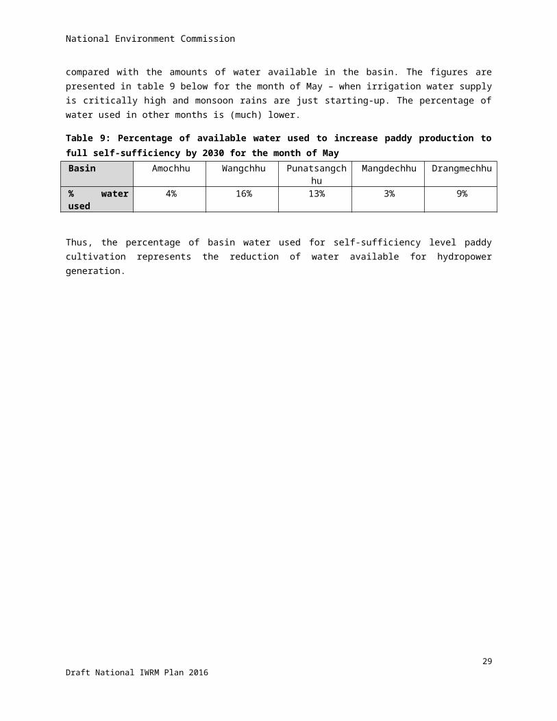
National Environment Commission
- Water management is based on a structural (long term) approach. For that reason a strategic plan must be drawn up for every river basin in which all relevant aspects should be considered and weighed in relation to each other. The river basin management plan is the reference for all types of operational activities.
- Local communities and other stakeholders involved in water management are given the opportunity to participate in all stages of the decision making process.
- Alongside the social function of water (expressed in the Act through the stipulation that every individual shall have access to safe, affordable and sufficient water for basic daily needs), the economic function of water is also underlined. Water use (abstraction/discharge) and water services are chargeable following the ‘user pays’ principle and the ‘polluter pays’ principle. This expresses the fact that water is a scarce commodity, which has to be paid for.
- The Water Act has a close relation with the National Environmental Protection Act 2007 ("NEP Act"). This act has a broad scope: the environment in all its dimensions, including water. The relation between the Water Act and the NEP Act has an institutional and a substantive dimension. The former concerns the regulation of the tasks and powers of the NEC, while the latter is related to the various rules about the protection of the environment.
- A final characteristic of the Water Act is its framework dimension. The topics covered by the Act are only provided for in broad terms. They need to be elaborated in one or more implementing government regulations. To ensure as much integration as possible, the government of Bhutan has decided to cover all issues in one integrated regulation, which was done through the Water Regulation 2014 (Water Regulation).
Addressing the different types of issues in the Water Act in one integrated regulation was a complex, challenging and time-consuming operation. Therefore, the preparation took quite some time but the Water Regulation came into effect in January 2015. However, not all issues are addressed in a sufficient manner. Based on the experiences in the practice, the Water Regulation will need to be updated.
Water Related Acts
As mentioned above, until the Water Act 2011 the management of water resources was fragmented, addressed in different laws, and only focused on the operational level. The most important acts that contain water related provisions are acts pertaining to land, forestry and nature conservation, mines and minerals management, electricity, waste, and environmental assessment and protection:
the Land Act 1979 and the Land Act 2007;
the Forest and Nature Conservation Act 1995, and Forest and Nature Conservation Rules 2006;
the Mines and Minerals management Act 1995;
the Electricity Act 2001;
the Waste Prevention and Management Act 2009.
the Environmental Assessment Act 2000;
the National Environmental Protection Act 2007
It is important that the Water Act and the water related acts (as well as their underlying implementing regulations) are sufficiently harmonized to avoid overlaps, contradictions or gaps. The Water Act addresses the relation with existing acts only in broad terms. Its Article 3 stipulates that: “This Act hereby repeals the provisions of any Acts/regulations and administrative instruments which are inconsistent with this Act”. To avoid misunderstandings and confusion in practice when inconsistencies arise, the above-mentioned existing water-related acts and
34Draft National IWRM Plan 2016
National Environment Commission
regulations need to be assessed, which has been done. The overall conclusion of the assessment is that the Water Act and the existing water related acts (and regulations) are harmonized. Most issues are addressed in the acts consistently, though in some cases there are inconsistencies that may cause confusion. More detailed information about the assessment can be found in a separate document supporting this NIWRMP.
Observations regarding the Legal Framework
The Water Act 2011 is the first act that addresses water resources in an integrated manner and is therefore an important milestone in the implementation of the IWRM concept in national legislation. All relevant issues are addressed in the Act and elaborated on in the Water Regulation 2014. Given the absence of experience with IWRM in practice, most issues are addressed conceptually in the new legal framework and have not yet been elaborated in sufficient detail to guide the full implementation of the new legislation in practice. This section provides some examples following a thematic approach. The ‘observations’ made in this section are not exhaustive. Furthermore, some of them, such as the institutional framework, are discussed in more detail in other sections of this NIWRMP.
Institutional Framework
A clear and transparent institutional framework, taking into account the river basin approach and the decentralization concept, is essential. The task division between the various competent authorities needs to be addressed in a clear manner to avoid misunderstandings about the question of who is responsible for what, and which is the competent authority to take decisions (such as issuing a license and imposing administrative sanctions). Unfortunately, this is not always done well enough. This is particularly the case for the NECS, the River Basin Committee (RBC), and the Water User Association (WUA). Furthermore, the decentralization approach needs further attention. The essence of this approach is: decentralize what is possible, centralize what is necessary. The ability of the NECS to hand over certain powers to the districts and the municipalities has so far been used in a limited way.
The issue of the institutional setup is elaborated in more detail in section 4.5 below.
Planning
A structured long-term approach through planning is a key element of IWRM. The two key planning instruments in the Water Act are the National Integrated Water Resources Management Plan (NIWRMP) and the River Basin Management Plan (RBMP). In principle, these instruments are well covered. However, the relation between the RBMP and the Watershed Management Plan needs further attention. A coordination mechanism to ensure that both plans are sufficiently harmonized is missing.
Regulatory framework
The Water Act and the Water Regulation, together with the Environmental Assessment Act set out a comprehensive and differentiated regulatory system for water abstraction and use. Some cases require applying first for an environmental clearance while others don’t and only necessitate a permit. The system will need to be tested in practice and if necessary adjustments made to it to facilitate its application.
Financing
Key points of the financing arrangement in the Water Act are the establishment of fees and charges based on the principles: user pays and polluter pays. Their elaboration in the Water Regulation is incomplete. The focus is on fees/charges in relation to the Environmental Assessment Act. Criteria regarding the amount of a fee or charge for surface or ground water use are not clearly set out.
35Draft National IWRM Plan 2016

National Environment Commission
Compensation is also an important element of the financing set up. In the event of governmental decisions causing damage those affected have a legal right to compensation. This issue is not consistently addressed in the legislation.
Dispute resolution
An overarching feature of the dispute resolution mechanisms in the Water Act is that it is a good example of the implementation of the decentralization approach. However, there remain issues to be addressed. Among other things, the current operational role of the NECS in this context needs attention. Whether this operational competence is consistent with the primary coordination task of the NECS should be reconsidered.
Enforcement
Enforcement is an important issue with a broad scope. One of its key element is supervising compliance with the law by monitoring and inspection, and based on that, the application of administrative and, or, criminal sanctions where necessary. The administrative sanctions are set out clearly. However, that is not the case for criminal sanctions.
4.3 Overview of the national planning process and entry points for IWRM
Since 1961 Bhutan’s development has been guided by a series of five-year plans (FYP), the preparation of which is directed by the Gross National Happiness Planning Commission, subject to the National Assembly's final approval. The current FYP is the eleventh in the series and covers the period 2013-2018. The planning/fiscal year begins in July.
The planning activities for the 11th FYP started in April 2012, during which central and local government plans were prepared by local government units and central agencies. Sectoral plans were prepared nationally by the line ministries, and harmonized with the development plans prepared by local governments. At the local level, stakeholders first identify which development activities are best suited for implementation at the level of the Gewog, at the level of the Dzongkhag, or that of the sector (national level).
This mode of decentralized planning, down to the level of the Gewog, was first introduced during the 9 th FYP. In the 10th FYP, planning processes continued to be further decentralized, giving greater autonomy for sectors and local governments to formulate strategies and to select priority programs (subject to budget resources available through their respective annual grants).
Beginning with the 10th 5-year plan, and continuing through the 11th FYP, a results-based planning framework was adopted that identifies clear outcomes and outputs to be achieved, see figure 17 below. Outcomes are defined as Key Results Areas (KRAs) at the national, sectoral, and Dzongkhag level, which are categorized under each of the four GNH pillars and were set after extensive stakeholder consultations spanning 2 years. At the national level, 16 KRAs have been identified. At the sector and Dzongkhag levels, there are more than 300 KRAs aligned with the 16 national KRAs. The performance of all government agencies towards the delivery of KRAs is measured through corresponding Key Performance Indicators (KPIs) consisting of baselines and targets.
36Draft National IWRM Plan 2016
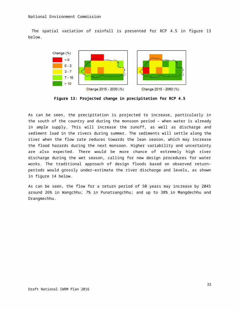
Sector Key Result Areas (SKRAs) supported by key performance indicators
Result-based programs ofsector agencies
Result-based programs at local government, organized by sector
IWRM entries IWRM entries
11th FYP Goal: Self-reliance and inclusive green socio-economic development
National Key Result Areas (NKRAs) supported by key performance indicators
National Environment Commission
The result based planning is essentially meant to ensure that sector and agency plans contribute to attainment of clearly stated results, the latter defined as outcomes of the specific development activities (program and project levels). The RBP framework was also meant to ensure that planning and budgeting processes are able to anticipate emerging challenges in the country’s socio-political and development context in the coming years.
Since the 10th 5-yr plan, the planning and budgeting timeframe for implementing programs and projects has been changed to 3 years, from the original 5 years in the previous FYPs. The FYPs continue to provide the medium-term outlook in identifying priorities and monitoring results, but these plans are operationalized through multi-year rolling plans of three years (1+2) which are rolled over from year to year based on annual work plans. This system allows for improved predictability and realism in the budgeting process.
A 1+2 rolling plan refers to a plan for the coming year, plus two years in advance. That is, central and local governments prepare annual plans with additional 2-year projections on program activities and budgetary targets.
Development plans at both national and local levels are consolidated under either infrastructure or non-infrastructure categories. The infrastructure items are required to be based on master plans that serve as road maps for infrastructure development, and which are then implemented on the basis of 3-year rolling plans.
Possible IWRM entry point: Prepare for the next FYP to systematically integrate IWRM in the medium-term development planning and resource allocation via the policy & planning guidelines that can be used as basis in the next (12th) FYP, possibly with initial focus on irrigation infrastructure if prioritized by the government.
37Draft National IWRM Plan 2016
Figure 17: Diagram of the national planning process under GNHC
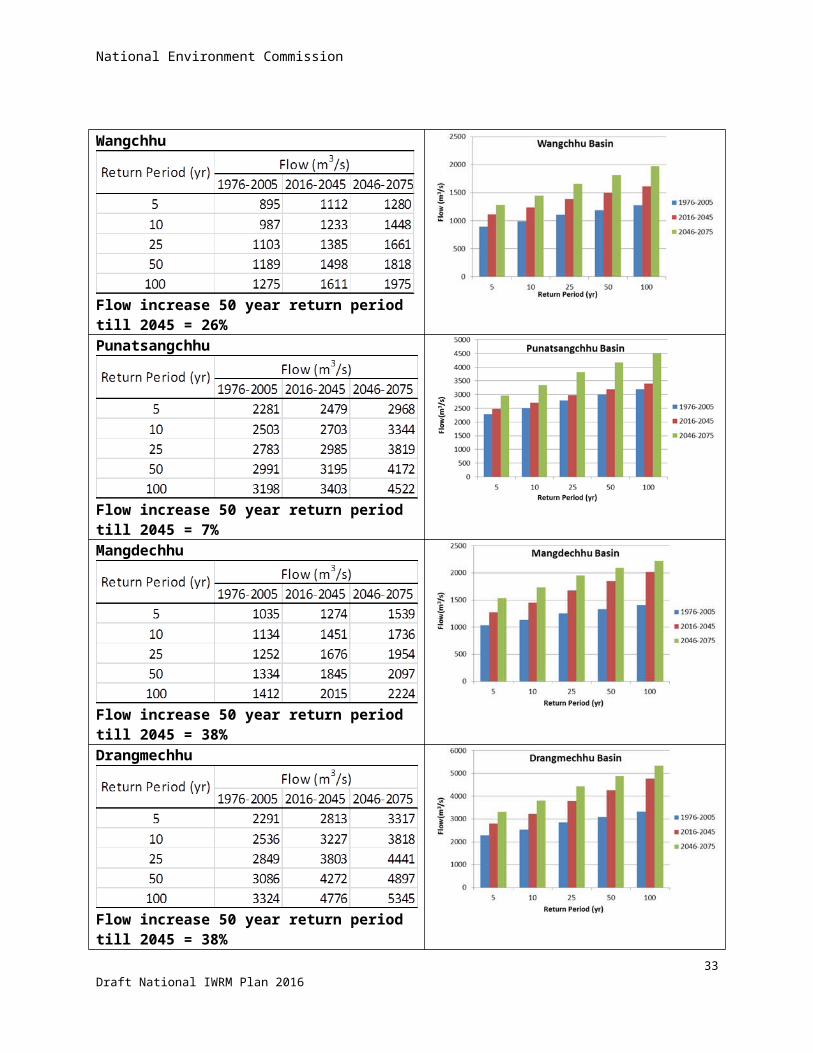
National Environment Commission
Possible IWRM entry point: Introduce KRAs for water security along the five dimensions of: rural water supply provision, urban water supply and water quality security, economic water security for agriculture and hydropower use, sustainable environmental flows, and climate change resilience.
Medium-term sector planning starts about midway through the current FYP guided by results of the mid-term review of the current plan implementation. After extensive consultations are held with stakeholders at local up to central levels, the identified development gaps and priorities (as “key interventions”) are sorted out according to how they should be pursued: as local activity at the Gewog or District level, or as part of a wider sector plan.
Guidelines for FYP planning are then drawn up by the GNH commission, wherein core sector objectives, priorities and strategies are set out. The guidelines serve as basis for the sector agencies to formulate their respective sector plans (and also for the local governments). Such plans are expected to clearly articulate expected results and ways to monitor progress of achievement (through sector KRAs and performance indicators).
The main sector interventions, KRAs and KPIs are compiled based on the extensive consultations conducted with stakeholders, and which are consolidated and presented formally to the GNH Commission prior to adoption and publication in the guidelines. Medium-term sectoral plans are developed based on the key interventions, key result areas and performance indicators that are specified in the planning guidelines.
Although sector agencies are given flexibility to modify the interventions in preparing their respective sector plans based on the GNHC guidelines, changes in KRAs and KPIs have to be cleared with the commission. Detailed specifications of each sector’s programs and projects are finalized after the resource allocations for all sectors are set by the commission based on the fiscal projection. Each sector plan’s specifications of programs and projects are accompanied by a “responsibility framework” that identifies the level of implementation (national or local) and the allocation of budget resources between the central sector agency and the local governments. The responsibility framework is issued by the GNH commission as an attachment to the planning guidelines.
Entry Point for IWRM. An envisioned entry point for IWRM mainstreaming in Bhutan’s development planning system is to influence the GNHC planning guidelines through adopting water security KRAs and KPIs derived from the national IWRM plan, which also serves to guide preparation of basin plans. And following our “strong coordination” model described above for IWRM, water concerns—that are spread out across various agencies—built into the national planning system will help ensure such coordination (including synergy among interventions).
Following our mainstreaming approach, strategic water security interventions, KRAs and designated competent authorities--derived from the national IWRM plan--will be coordinated by the WRCD and presented by the NEC Secretariat (through the NEC) to the GNHC, after which these proposed to be formally adopted and published in the medium-term planning guidelines. Specific plans at the national and local levels are to be developed based on the planning guidelines, and such plans will be reviewed by the GNHC Secretariat for conformity.
Detailed specifications of programs and projects are finalized after the resource allocations for all sectors are set by the national planning commission based on the budget projection. The plan specifications are to be accompanied by a “responsibility framework” that identifies the level of implementation (national or local) and the allocation of budget resources between the central sector agency and the local governments. The responsibility framework is issued by the GNHC as an attachment to the planning guidelines (and incorporated in the compact signed by the executing agencies and the government). Note that we are not expecting the RBOs be designated as separate implementing units because their role is principally to coordinate local plans.
In current 11th FYP for the renewable natural resources (RNR) sector, for instance, the water-related KRA is stated as “enhanced sustainable forest, land, water and biodiversity resource management” for which the identified key intervention is to “conduct inventory of important water catchment areas and effectively manage critical catchments.” For the next FYP, it is expected that additional water security KRAs and strategic interventions will be identified.
38Draft National IWRM Plan 2016

National Environment Commission
At the basin level, with the RBC providing coordination through the river basin management plan, water-related plans will be prepared by the Dzongkhag and Gewog administration units (through their respective development councils), and with reference to technical guidelines issued by the competent water-related agencies/authorities as designated by the NEC. Each local plan will identify which strategic element under the GNHC planning guidelines are to be implemented at the local level (and, following the budget system, to be funded through allocations from central agencies in the form of grants earmarked for those activities).
According to the 2014 Water Regulation, every Dzongkhag Administration will prepare an Integrated Water Use Management Plan for the Dzongkhag based on the NIWRMP for adoption by the Dzongkhag Tshogdu. Every Thromde Administration will develop a water management/safety plan based on demographic projections for at least the next ten years to ensure efficient water supply and effluent disposal, including drainage systems, in its jurisdiction.
4.4 Water-related priorities in the Vision, Policy and PlanningThe priorities given in the Vision and Policy statements, and formulated as Key Result Areas in the 11th FYP are summarized in table 10 below. For purposes of presenting the priorities so that these are aligned with the IWRM framework based on water security dimensions, as explained in chapter 5, the priorities are sorted along five key dimensions.
The water security framework adopted for Bhutan’s IWRM draws from ADB’s Asia Water Development Outlook (AWDO) indicator system for water security, which defines five key dimensions. The Asian Water Development Outlook was created through a collaboration between ADB and the Asia–Pacific Water Forum, in which Bhutan is a member, to highlight important water management issues. The five dimensions are as follows:
1. household water security (satisfy household water and sanitation needs in all communities)2. economic water security, in particular for irrigation and hydropower development (support productive
uses of water in agriculture, industry and energy)3. urban water security (develop vibrant, livable cities and towns)4. environmental water security (restore health of rivers and ecosystems)5. resilience to climate change and water-related disasters (build resilient communities that can adapt to
change)
Measuring the status of water security in these five dimensions captures the inherent tension among water uses that emerge as water resources come under increased competition among users. Indeed, managing these five key dimensions of water security, and their respective stakeholders, together constitute IWRM, and with climate change resilience taken into consideration.
39Draft National IWRM Plan 2016
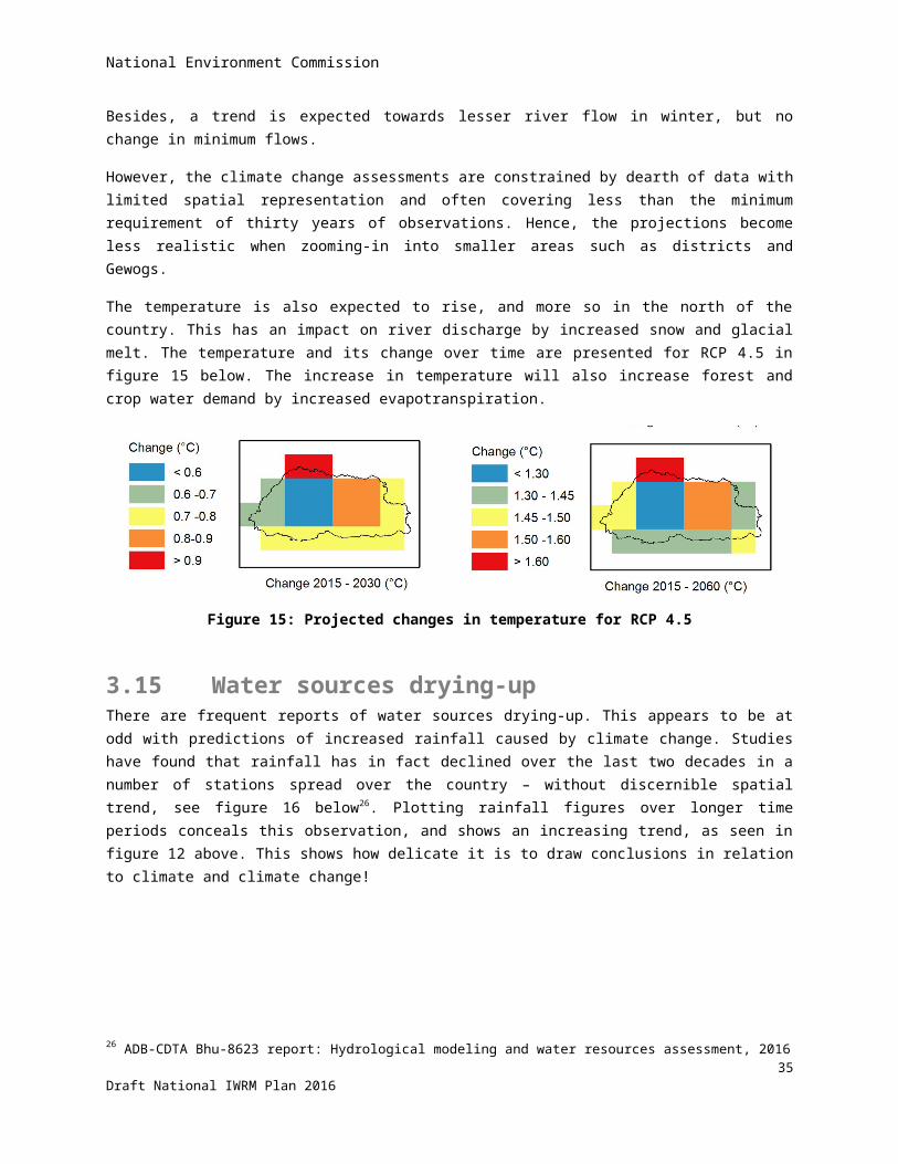
National Environment Commission
Table 9: Priorities in planningKD Source Domain Goal Indicator
1 Water vision goals Health Reduction in water-related diseases
-
Policy statements Drinking water & Sanitation
Universal access & water quality standards
Conservation of sources for drinking water supply
-
-
11th FYP Human settlement Improved quality of infrastructure facilities & services
Millennium Goals achieved
Incidence of communicable disease reduced
% of population with access to safe and reliable drinking water & sanitation
Improved sanitation facilities and hygienic use increased from 58% to >80%
Diarrhoea incidence per 10,000 under 5 children (2428)
2 Water vision goals: Agriculture Aquaculture Hydropower Industries Recreation
Increase food production/ irrigation
Develop fish farming Tap potential Adequate water allocation Develop water bodies
Policy statements Agriculture
Industries
Irrigation water supply as per national objectives (food security)
Minimize pollution from agro-chemicals
Production of ‘bottled water’/ clean water products promoted
All commercial abstractions to be licensed
Sustainable development of hot springs
11th FYP Energy Energy security enhanced Installed capacity of HPP toraise from 1,500 to 4,500 MW
Installed small HPP capacity 12,150 KW
3 Water vision Drinking water No explicit urban goals (other than drinking water supply & sewerage)
Water policy Drinking water No explicit urban plans (other than drinking water & sewerage)
40Draft National IWRM Plan 2016

National Environment Commission
KD Source Domain Goal Indicator
11th FYP Drinking water No explicit urban plans (other than drinking water & sewerage)
4 Water vision goals Environment Conservation of nature Water quality monitoring
Policy statements Industries
Environment
Proper waste water disposal
Preservation of river habitat
11th FYP Renewable Natural Resources
Enhance conservation of plant and animal genetic source
Increase number of protected RAMSAR sites from 0 to 5.
5 Water vision goals Resilience Forecast, prevent, mitigate disasters
Policy statements - No policy statement formulated
11th FYP Conservation & sustainable utilization of environment
Climate change induced GLOF risk mitigated
Maps of dangerous glacial lakes updated
4.5 Institutional framework and stakeholder analysis
The following paragraphs provide a stakeholder analysis of the institutional framework. It exists of an exhaustive descriptive outline of the institutional framework, followed by some observations.
Outline of the Institutional Framework
The following section identifies the key institutions in Bhutan’s evolving IWRM, and whose respective roles have been defined in Chapter 3 of the Water Act and (in a more detailed manner) in Chapter 2 of the Water Regulation. The Table briefly describes the primary mandate of each institution and also their specific IWRM roles with regard to (i) policy and planning, (ii) coordination and regulatory powers, (iii) water services delivery, and (iv) information management/reporting and capacity building. Training needs are identified in relation to these four categories of IWRM roles and functions.
1. Ministry of Agriculture and Forests (MoAF)
MoAF is the Competent Authority on irrigation, watershed and wetland management. It is responsible for development of irrigation systems and management of watersheds throughout the country. The Engineering Division of the ministry provides engineering services to local administrations for design and development of irrigations systems. The Watershed Management Division (under the Department of Forest and Park Services) is tasked to categorize watersheds, prepare management plans, and implement them in collaboration with stakeholders.
WRM policy and planning role: Coordination and Regulatory role:
41Draft National IWRM Plan 2016
National Environment Commission
Formulate, implement and periodically review a comprehensive National Irrigation Policy
Develop and implement watershed and wetland management plans
Identify watershed areas that require protection, conservation and management for sustainable supply of water;
Conduct feasibility studies on new irrigation systems
Ensure the protection, conservation and management of watersheds to sustain water supply and other environmental services
Promote payment for environmental services mechanism to support watershed management programs
In consultation with NECS, develop and issue quality standards for irrigation water discharge
Water service delivery role: Ensure that water abstraction for irrigation
is in line with NIWRMP Design irrigation water conveyance
infrastructure and implement these optimize water use efficiency
Ensure reliable and efficient water supply system for cropping intensification and diversification
Ensure that the concept of eco-efficient water infrastructure is followed while developing irrigation systems
Facilitate the formation and registration of an irrigation WUAs and monitor them
Information, reporting, research and capacity-building role:
Develop comprehensive inventory on irrigation systems in the country and update annually
Identify cost effective irrigation technologies and encourage adoption
Promote cropping patterns and land use management suitable to water availability conditions
Conduct seminars or training for members of the irrigation WUA on efficient water management
Explore alternative water resources like rain water harvesting and hydropower reservoirs
Involve Civil Society Organizations to educate, inform and train farmers on watershed management practices
Set up an irrigation water management unit under its existing Research and Development Centres
Conduct research on best practices in water management
Develop and implement an effective M&E and reporting system for irrigation systems
Submit annual report to the NECS on implementation and enforcement of Water Act and Regulation, including difficulties, issues and challenges met
2. Ministry of Economic Affairs (MoEA)
Through MoEA’s Department of Hydropower and Power Systems, it has the responsibility of promoting sustainable hydropower development for Bhutan. Its mission is to govern and facilitate integrated, regionally balanced and optimal use of water for development of hydropower with minimum environmental impacts; ensure that hydropower generates maximum revenue to the nation; ensure secure, reliable, and affordable electricity for the Bhutan; provide enabling environment for participation of the public and private sectors in development of hydropower resources; implement institutional reforms for efficient planning and management of the sector; and develop and enhance professionals for hydropower development and management. Through the Department of Hydro-Met Services, it provides weather, water, climate, and other related environmental services to
42Draft National IWRM Plan 2016
National Environment Commission
various sectors. It services provided by the agency include daily weather forecast, agro-meteorological information, warnings and alerts for extreme events such as GLOF, and hydro-meteorological data. The Department of Geology and Mines, through its Glaciology Division carries out monitoring of Glaciers and Glacial Lakes, update inventory of Glaciers and Glacial Lakes, conduct research on Glacial Lakes and propose remedial measures for GLOF risk reduction, implement mitigation measures and study impact of climate change on Glaciers and Glacial Lakes.
WRM policy and planning role: For the NIWRMP, monitor water flows and
sediments in river courses to control and mitigate adverse environmental impacts from the dam constructions, river diversions, mining and industrial activities
Assist in developing the NIWRMP and take measures to implement it in relation to hydropower activities and river ecology
Consider hydropower planning for multiple uses such as drinking water, irrigation and recreational purposes
Coordination and regulatory role: Coordinate river-related activities in
collaboration with the RBC Ensure the effective implementation of
guidelines on safety measures to be taken while planning, designing and implementing hydropower dam construction
Ensure minimum environmental flow to be maintained in rivers while planning hydropower projects
Water service delivery role:None
Information, reporting, research and capacity-building role:
Monitor water flows and sediments in river courses
Collect, analyse and disseminate data on water resources pertaining to planning and implementation of hydropower projects
Conduct studies on glacial dynamics for GLOFs
Submit annual report to the NECS on implementation and enforcement of Water Act and Regulation, including difficulties, issues and challenges met
3. Ministry of Education (MOE)
The MoE does not have direct water management and service delivery mandates specified in the Water Act and the Water Regulation. Its main role, as one of the competent authorities mentioned in the Water Act, is to promote awareness of water-related issues among the general public.
WRM policy and planning role:None
Coordination and regulatory role: Coordination information gathering for
educational and public awareness-raising purposes
Water service delivery role: None
Information, reporting, research and capacity-building role:
Collect information on water resources from other Competent Authorities and incorporate these into its education programs and curriculum
Conduct educational activities to sensitize and create awareness among
43Draft National IWRM Plan 2016

National Environment Commission
the general public on the importance of water resources management
Submit annual report to the NECS on implementation and enforcement of Water Act/Water Regulation, including difficulties, issues and challenges met
4. Ministry of Health (MoH)
Ministry of Health is responsible for the overall planning, implementation and management of infrastructure for drinking water supply and sewage management for all rural areas, which it undertakes in collaboration with local governments. It is also mandated to monitor quality of drinking water. MoH is mandated under the Water Act and the Water Regulation to mainstream water resources management in its policies, plans and programs. Although spring sources are to be given preference as a drinking water source, the ministry is mandated to explore alternative drinking water resources like rainwater harvesting and tapping of hydropower reservoirs.
WRM policy and planning role: Review existing status of drinking water
supply systems in rural areas Develop national master plan for rural
drinking water and wastewater management (with emphasis on spring sources)
Develop, issue and revise guidelines on water safety plans and “eco-efficient” water infrastructures
Coordination and regulatory role: Assist NECS in developing and revising
drinking water quality standards Designate focal persons to monitor
water quality standards in Thromde and rural areas.
Water service delivery role: Implement measures to ensure reliable and
efficient drinking water supply systems in rural areas
Identify and provide incentives or subsidies for water saving schemes or better wastewater management for rural areas
Information, reporting, research and capacity-building role:
Explore alternative drinking water resources like rain water harvesting and possible linkage to hydropower reservoirs
Maintain and periodically update records of physical, chemical and biological findings with respect to drinking water at the consumer level
Raise awareness of disinfectant mechanisms and on water borne diseases among water users
Develop training materials on water safety
Submit annual report to the NECS on implementation and enforcement of Water Act and Regulation, including difficulties, issues and challenges met
5. Ministry of Home and Cultural Affairs (MOHCA)
The Ministry of Home and Cultural Affairs, through its Department of Disaster Management, is involved in the water sector in terms of disaster mitigation and relief, especially in water-related disaster such as Glacial Lake Outburst Floods (GLOFs).
WRM policy and planning role: Develop system to inform the public in
times of water related natural disasters
Coordination and regulatory role: Coordinate on disaster preparedness and
mitigation measures to be taken
44Draft National IWRM Plan 2016
National Environment Commission
Make local governments accountable for the protection and promotion of local cultural practices that are environment friendly and that protect water bodies recognized as abodes of deities
Service delivery role: Inform the public in times of water-related
natural disasters
Information, reporting, research and capacity-building role:
Maintain registries on well-known therapeutically valued water bodies, and ensure their sustainable use
Discourage pollution of water bodies caused by disposing religious effigies, ritual cakes, cremation remnants, etc.
Submit annual report to the NECS on implementation and enforcement of Water Act and Regulation, including difficulties, issues and challenges met
6. Ministry of Works and Human Settlements (MoWHS)
MoWHS is responsible for the overall planning, implementation and management of infrastructure for drinking water supply and wastewater for the Thromde in collaboration with local governments. It assesses strengths and shortfalls for water supply maintenance, and identifies remedial measures. It is mandated to prepare its development plans in consultation with local governments. Like the Ministry of Health, it is mandated to mainstream water resources management into its policies, plans and programs.
WRM policy and planning role: Review existing status of drinking water
supply systems in Thromdes Develop a national master plan for the
drinking water and waste water management system for Thromdes
Develop, issue and revise guidelines on water safety plans and eco-efficient water infrastructures
Coordination and regulatory role: Ensure proper implementation of Water
Safety Plans through regular monitoring and evaluation
Water service delivery role: Implement measures to ensure reliable and
efficient drinking water supply systems in urban municipalities
Identify and provide incentives or subsidies for water saving schemes or better wastewater management
Information, reporting, research and capacity-building role:
Explore alternative drinking water resources like rain water harvesting and hydropower reservoirs
Conduct studies on, and encourage use of, environment friendly, cost effective and water efficient technologies
Provide training on water safety plans and eco-efficient water infrastructures
Submit annual report to the NECS on implementation and enforcement of Water Act and Regulation, including difficulties, issues and challenges met
7. National Environment Commission (NEC)
NEC was established in the early 1990s and acts as the highest authority and decision-making body on all matters relating to policies, plans and guidelines for managing environment and water resources. The commission derives its powers and functions from
45Draft National IWRM Plan 2016

National Environment Commission
the overarching National Environment Protection Act 2007, the Environmental Assessment Act 2000, Waste Prevention and Management Act 2009, the (latest) Water Act of 2011. Under the Water Act, NEC serves as the apex authority for the purpose of developing policies, plans, programs and monitoring water resource management in the country. The NEC members are appointed by the Cabinet and comprised primarily of high-level ministerial members representing the relevant government Ministries, representatives of the private sector, Civil Society Organizations (CSOs) and an advisor to the Commission. The Prime Minister serves as the Chairperson, and the Secretary of NECS serves as the Secretary. The MoAF Minister has been designated as the Minister in-charge for NECS and serves as the vice-chairperson of the Commission.
WRM policy and planning role: Implement the IWRM principles enshrined
in the Water Act Review and adopt the National Integrated
Water Resource Management Plan (NIWRMP) for its incorporation into national policies, plans and programs
Review and adopt guidelines for water resource management plans including River Basin Management Plans (RBMPs)
Form River Basin Committees for preparation of the River Basin Management Plans
Review and adopt the Water Regulation Protect and promote a safe and healthy
environment Prevent, control and abate environmental
harm, including pollution Ensure conservation and sustainable use of
natural resources Negotiate and enforce bilateral and
multilateral agreements related to water resources
Update water law and regulation
Coordination and regulatory role: Ensure effective enforcement of the
Water Regulation by Competent Authorities represented in the NEC
Institutionalize the environmental assessment process and environmental clearance system as an integral part of the water resource development planning process
Coordinate the activities of the various CAs through the NEC Secretariat
Water service delivery role:None
Information, research and capacity-building role:Carried out through the NEC Secretariat
8. National Environment Commission Secretariat (NECS)
The NECS carries out the day-to-day functions of the National Environment Commission. It assists the NEC in administering the provisions in the Water Act. Headed by a Secretary (who is also a member of the NEC), the NECS is comprised of five divisions: (i) Services division providing administrative and program services, (ii) Environmental Services Division primarily dealing with Environmental Clearances, (iii) Compliance Monitoring Division, (iv) Water Resources Coordination Division and (v) Climate Change Division. Each Division is headed by a Chief. District Environmental Officers (DEOs) who are administratively under the Dzongkhag administration units carry out the functions of NECS at the district level. They report directly to the district governor, although they are also answerable to the NECS. A Water Resource Coordination Division (WRCD) was set up in May 2010 in accordance with a Cabinet Directive upon recommendation of the NEC.
WRM policy and planning role: Prepare National Integrated Water
Coordination and regulatory role: Develop appropriate standards for water
46Draft National IWRM Plan 2016
National Environment Commission
Resource Management Plan Review and adopt River Basin Management
Plans and forward them to the Gross National Happiness Commission for mainstreaming into national plans
regulation In coordination with Competent
Authorities, review and revise the Water Regulation
With competent Authorities, enforce water quality standards
Coordinate among Competent Authorities to develop inventories on water resources, both on quality and quantity baseline data
Assess and issue environmental clearances for projects including water related projects and programs
Issue directives that are binding on all persons and competent authorities for purposes specified in the Water Act
Water service delivery role:None
Information, research and capacity-building role:
Monitor the state of water resources and compile, analyse and disseminate information
Collaborate with the MoAF, MoEA, and the River Basin Committees to develop and maintain inventories on river hydrology, aquatic habitat, river ecology and morphology to enable scientific determination of minimum environmental flow to be maintained by hydropower projects
Initiate and support research works on water related areas
Develop a reporting format to be used by Competent Authorities as general guidelines for reporting under this Regulation
Develop and maintain a National Registry on both drinking and irrigation water resources and river basin management
9. Gross National Happiness Commission (GNHC)
The erstwhile Planning Commission was renamed Gross National Happiness Commission (GNHC) by the first democratically elected government in 2008. GNHC is the apex body for setting the development priorities and plans for the country based in the four pillars of GNH. The Commission is comprised of high level ministerial members appointed by the Cabinet. The Secretary of the commission’s Secretariat serves as the member Secretary.
WRM policy and planning role: Review and endorse policies and guidelines
for national planning that incorporate all sector concerns including water
Review and endorse national vision documents (example Vision 2020) and Five Year Plans that contain water related targets.
Coordination role: Deliberate inter-ministerial coordination
issues during commission meetings Review progress reports consolidated
and submitted by GHNC Secretariat. Delegate day to day coordination
functions to the Secretariat
47Draft National IWRM Plan 2016
National Environment Commission
Water service delivery role:None
Information, research and capacity-building role:Carried out through the GNHC Secretariat
10. Gross National Happiness Commission Secretariat (GNHCS)
The GNHC Secretariat is the administrative and programs machinery serving to fulfil the functions and priorities of the GNHC. Planning officers across the country support the Secretariat with local and sectoral plans.
WRM policy and planning role: screen policies proposed by line agencies in
the government develop guidelines for national planning set sector KRAs and KPIs Review and endorse national vision
documents (example Vision 2020) and Five Year Plans that contain water related targets.
Coordination role: Consolidate plans and priorities with
clearly defined KRAs and KPIs at national, district and Gewog levels.
Screen and approve project proposals from sectoral agencies.
Monitor progress against plans through online Planning and Monitoring System (PLaMS).
Liaise with Prime Minister’s Office in defining targets for annual compacts with sectors.
Mobilize resource in collaboration with Ministry of Finance and facilitate fund flow.
Water service delivery role:None
Information, research and capacity-building role: Repository of information on on-going
and past plans of Gewog, Dzongkhag, Ministries and other governmental agencies.
Conduct research to facilitate development planning
Develop monitoring and reporting tools Build capacity of planning officers
11. Civil Society Organizations (CSOs)
The relevant CSOs are the Royal Society for the Protection of Nature (RSPN) which is hosting the Bhutan Water Partnership (BhWP), the World Wildlife Foundation (WWF), and the Tarayana Foundation. The RSPN and BhWP have been engaged in water for sustainable livelihoods program whereby they work with concerned agencies in the government to support small-scale rural water supply, sanitation, and irrigation development initiatives. Tarayana Foundation engages at the grassroots level in rural livelihoods enhancement program especially in far-flung areas. WWF Bhutan Program provides financial and technical support to the government and NGOs in ecosystem services assessment, watershed management, and river basin planning.
WRM policy and planning role: Provide resources and inputs to the
preparation of IWRM and RBM plans
Coordination role: Promote public-private partnership
activities to control water pollution and conserve water resources
Water service delivery role:None
Information, research and capacity-building role:
Raise public awareness on the importance of preventing water pollution and sustainable use of water
48Draft National IWRM Plan 2016
National Environment Commission
resources; Educate and raise public awareness on
the use of alternative technologies for efficient water resource management; and
Inform the public on misuse or abuse of water resources by commercial entities
Conduct research and produce policy papers
12. Dzongkhag Tshogdu (district development council)
Local administrations are important players in planning, implementing and operating water projects. Bhutan’s 20 administrative districts are headed by appointed governors and are further divided into 205 Gewogs. Under the Local Government Act 2009, the Dzongkhag Tshogdu (district development council) acts as the executive body of the district, although they are not empowered to pass laws. The district councils are composed of elected leaders from each Gewog. Thromdes (urban centres) are subdivisions of the Dzongkhags that are more densely populated (i.e., urban municipalities) and have their own councils with directly elected members. District and Thromde councils are tasked with balancing socio-economic development, promoting business, protecting consumers, coordinating government agency activities, reviewing Gewog regulations and ordinances, and representing the districts in national referenda. They enforce rules on health and public safety, and regulate environmental pollution. District councils bear the responsibility for their own finances.
WRM policy and planning role: Identify elements under the national water
sector plan that are to be implemented at the local level
Specify KRAs to be addressed in the area development priorities (from the stakeholder consultations).
Plan water facilities for drinking water supply and irrigation
Incorporate the National Irrigation Plan (NIP) into its local water resources management plan
Provide technical inputs during preliminary investigations and multi-disciplinary feasibility studies on drinking and irrigation water abstraction proposals
Carry out detailed surveys, designs, drawings, estimates and bill of quantities of feasible irrigation and drinking water systems
Ensure that Water Safety Plans are developed and implemented
Coordination and regulatory role: Coordinate/collaborate with the
Dzongkhag administration’s Water Management Committee in planning water projects
Facilitate outsourcing of drinking water and irrigation engineering services to private sector in the Dzongkhag
Water service delivery role: Mobilize funds and implement drinking
water and irrigation projects in accordance with the NIP (and NIP operation and maintenance manual)
Conduct tender and execute contracts for the construction of drinking water and
Information, reporting, research and capacity-building role:
Establish an effective monitoring and evaluation system for irrigation and drinking water supply system
Submit reports on the progress status of water supply systems to concerned
49Draft National IWRM Plan 2016
National Environment Commission
irrigation facilities Supervise construction works on drinking
and irrigation water facilities Ensure that the water supply systems are
maintained regularly within its jurisdiction
Competent Authorities Submit annual report to the NECS on
implementation and enforcement of Water Act and Regulation, including difficulties, issues and challenges met
13. Gewog Tshogde (Gewog development council)
Each Gewog is administered by a Gewog Tshogde (Block Council or Block Development Committee), which is subordinate to the Dzongkhag Tshogdu (district council). The Gewog council is composed of a Gup (headman), Mangmi (deputy), and between five to eight elected leaders (Tshogpas) from among the constituent villages. Block council representatives serve five-year terms. The Gewog Tshogde is empowered to regulate resources, manage public health and safety, and levy taxes on land, grazing, cattle, entertainment, and utilities. The Gewog administration administers its own budget under the supervision of the Ministry of Finance. It also has jurisdiction over roads, buildings (including architecture), recreational areas, utilities, agriculture, and the formulation of local five-year development plans. However, the Gewog administration is not empowered to pass laws. Gewogs are further subdivided into Chiwogs, which are the equivalent of municipalities or cluster of villages. There are generally 5-6 Chiwogs in each Gewog. The Gup and Tshogpas prepare proposals for rural infrastructure in the five-year development plans and they organize local projects. They also settle community disputes (including water-related disputes), and decide the use of community resources including land and water. A Gewog Administrative Officer (GAO) plays a key role in initiating and facilitating the annual Gewog-level planning process.
WRM policy and planning role: Encourage the adoption of appropriate
drinking and irrigation technologies and good water management practices
Assist communities in identifying and conducting feasibility studies on new drinking or irrigation water system or maintenance of the existing infrastructure
Work with competent authorities in planning drinking and irrigation water projects
Coordination and regulatory role: Facilitate formation of WUAs and assist
in their registration with the Gewog administration
Ensure all water sources for drinking and irrigation are registered with the Gewog administration
Provide liaising services between community and Dzongkhag Administration or Competent Authorities on planning, execution and monitoring of drinking and irrigation water systems
Coordinate skill development activities for the members of registered WUAs
issue permit for water abstractions and use of source within their jurisdiction not requiring an Environmental Clearance
Water service delivery role: Implement and monitor national drinking
water and irrigation policies, following procedural manuals issued by Competent Authorities
Ensure regular maintenance of water supply systems
Ensure effective implementation of the Water Safety Plan
Assist Competent Authorities in the day-to-day supervision of water infrastructure construction and maintenance works
Information, reporting research and capacity-building role:
Monitor and evaluate drinking and irrigation water programs;
Develop and maintain separate inventories on irrigation and drinking water systems
Compile and submit periodic progress reports to the Dzongkhag Administration on drinking water and irrigation facilities
Maintain records of WUAs and make these records available to relevant
50Draft National IWRM Plan 2016
National Environment Commission
Competent Authorities for technical or financial assistance
Cooperate and assist other Competent Authorities in research activities on drinking or irrigation water management systems in the Gewog
Submit annual report to the NECS on implementation and enforcement of Water Act and Regulation, including difficulties, issues and challenges met
14. Dzongkhag Water Management Committee
Under the Water Regulation, for the purpose of proper and effective protection and management of water resources at Dzongkhag level, the existing Dzongkhag Environment Committee (DEC) shall, with additional members as may be necessary, function as the district water management committee (DWMC).
WRM policy and planning role: Provide technical determination on the
issues of water volume, water sufficiency at source and the carrying capacity of infrastructure for proposed additional water users
Determine whether an existing water supply system is sufficient at source for the planning of new or expanded water uses/users
Provide technical advice to the Dzongkhag Administration for planning of drinking and irrigation water
Coordination and regulatory role: Coordinate with other competent
authorities in assisting WUAs to determine whether an existing water supply source/system is sufficient for proposed new or expanded water uses/users
Collaborate with other DWMCs in the basin, and issue recommendations to concerned Competent Authorities pertaining to inter-Dzongkhag plans and programs
Issue permit for surface water abstractions and use of a source within their jurisdiction not requiring an Environmental Clearance
Issue permit for groundwater abstractions (if necessary with technical assistance of NECS)
Water service delivery role: None
Information, reporting, research and capacity-building role:
Determine and issue technical opinion for local authorities and concerned parties on water-related issues
Submit annual report to the NECS on implementation and enforcement of Water Act and Regulation, including difficulties, issues and challenges met
15. River Basin Committees (RBCs)
The Water Act mandates that such committees shall be set up for the “purpose of proper management of water resources.” Functions described in the Act pertain to community participation, preparation of the RBM plan, monitoring and reporting to NEC, data management, and resolution of cross-sectoral and trans-boundary water management issues. However, the Act gives prerogative to NEC to direct RBCs to perform additional functions.
WRM policy and planning role: Coordination and regulatory role:
51Draft National IWRM Plan 2016
National Environment Commission
prepare River Basin Management Plans together with the NECS:o Consolidate water resources
management plans prepared at the district level, including those of sectoral agencies involved in water management, and ensure that these are reflected in the basin plan (i.e., checking that the plans do not draw more water than is available
o Ensure that the basin plan is consistent with the principles and objectives of the NIWRMP.
o water-related Key Result Areas (KRAs) and Key Performance Indicators (KPIs) incorporated in the GNHC’s medium term planning guidelines are reflected in the basin plan
Mobilize and allocate resources for basin wide program
Establish procedures/rules for hearing and resolving trans-boundary water allocation issues
Serve as forum through which issues/disputes related to water sharing and distribution among districts within the basin can be discussed and resolved in an informed and consultative manner
monitor and report to the Commission on the effectiveness of policies and action in achieving sustainable management of water resources in its area of operation
With NECS, develop guidelines for coordinate basin level registry of water user associations (WUAs)
Water service delivery role: Prioritize and allocate water resources for
various purposes
Information, reporting, research and capacity-building role: Collect, manage and share such data
as are necessary to properly manage the basin in coordination with the Commission - Establish baseline data on the
water security indicators for the basin, following the framework set up by the NEC and GNHC for a national water security indicator system
- Based on the basin plan implementation reports of the Dzongkhag and Thromde administrations, consolidate data to periodically update the water security indicators for the river basin, and report these to the NEC and GNHC, as well as to the basin consultative council.
- Facilitate the exchange of data and information among agencies operating in the river basin, and among the district and Gewog level administrations
Submit annual report to the NECS on implementation and enforcement of
52Draft National IWRM Plan 2016
National Environment Commission
Water Act and Regulation, including difficulties, issues and challenges met
16. Water Users Associations (WUAs)
Except in Thromdes, water users of a water facility are to be established. The term “water user” for the purpose of forming a WUA means a household using water from a registered facility or source. Any new water user duly admitted to an existing facility will automatically be a member of the WUA.
WRM policy and planning role: Formulate, adopt and enforce rules for the
use and management of drinking and/or irrigation water within the WUA
Protect and conserve the WUA water source
Ensure (enforce national policy) that every household belonging to the WUA has equitable and fair access to drinking and/or irrigation water supply and that no person is arbitrarily denied basic daily water needs
Determine and adopt water user fees that commensurate with the services rendered by its members
Exercise other powers and functions as may be delegated by a Competent Authority to the WUA
Coordination and regulatory role: administer/coordinate admission and
participation of water users in the WUAs Acknowledge customary practices When necessary, request Gewog
Administration for the determination of water availability to admit new water users to its Association, and if there is no such expertise at the Gewog level, it will request Dzongkhag Administration for technical assistance
Admit or decline the admission of new users to the WUA, depending on water availability at source and carrying capacity of the water services infrastructure
Issue letter of consent to temporary water users from the WUA’s water facility
Request intervention of Gewog Administration when there are undue developmental activities being sighted in and around its water source
Federate with other WUAs to improve water resource management
When necessary, invite district forest officer, health worker or engineers to attend WUA meetings for technical and other support
Water service delivery role: Mainly through water allocation and
resolution of water disputes Appoint one or more negotiators to settle
disputes amicably before considering to render decision by casting votes by its users
Decide on punitive actions for members failing to comply with the standing rules of the Association
Hear and decide on disputes between or amongst its members relating to water and infrastructure use
Allocate and maintain a water tap point, at a strategic location within a group of households, for fire emergency purposes
Take necessary measures for the efficient
Information, reporting, research and capacity-building role:
Keep records of irrigable land holdings of WUA members and means of water distribution
Maintain records of minutes of its meetings and decisions taken by the Association
Keep books of accounts on the money received and disbursement made by the Association
Exchange information with WUA federation
53Draft National IWRM Plan 2016
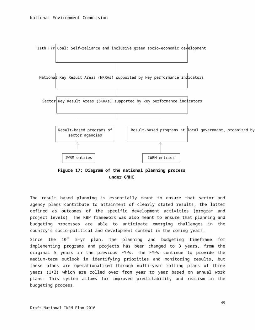
National Environment Commission
use of water Appoint water guard for irrigation and/or
drinking water protection
Observations with respect to the Institutional Framework
The outline in the table above of the role and functions of the various institutions on central, district and local level shows that a lot of institutions are involved in water management. Most of them have the feature that they only have tasks related to specific aspects of water resources. One of the main goals of the Water Act is to create the conditions for a shift from a fragmented approach to an integrated approach of the management of water resources. To ensure effective coordination between the involved institutions the Water Act establishes two coordinating apex bodies: the NEC (and its Secretariat) at a national level, and the RBC at a river basin level. The NEC(S) is an already existing body established in the early 1990s and legally embedded in the National Environment Protection Act 1997. The RBC is a totally new institution and not based on any experience with it in practice.
The institutional model regarding the management of water resources is a complex model. It is based on the idea that the water management tasks have to be carried out as far as possible by the existing government bodies and that the both apex bodies have the task to ensure that the line agencies carry out their water tasks in an integrated manner. An effective implementation of this institutional model requires that the role and the functions of all bodies are clearly set out in the legislation to avoid misunderstandings, duplications, or even contradictions. This section briefly analyses the question if this is the case. It discusses in broad terms the new established bodies: NEC(S), RBC, and WUA in relation to the existing government bodies.
The NECS
One of the main functions of the NECS is the preparation of the NIWRMP in consultation with the relevant stakeholders. This is a crucial coordination instrument at the national level. The same applies to the approval task of the RBMP prepared by the RBC. The approval power of the NECS is essential to ensure that a RBMP is in line with the NIWRMP. Both coordination instruments are undisputed. The NECS also has more operational tasks like monitoring the state of water resources; the development and maintenance of a National Registry on both drinking and irrigation water resources; the development and maintenance of inventories on river hydrology, aquatic habitat, river ecology and morphology; the competent authority for the issuing of a clearance certificate; and appeal body in water disputes. One can image that performing these tasks requires sufficient staff capacity, which is not case at the moment. But apart from that, it is questionable if all these operational tasks are typical coordination tasks that need to be carried out by the NECS. The Water Act creates the possibility for the NECS to hand-over one or more functions to other agencies. It should be considered to use this opportunity to ensure that the NECS can focus on the essential strategic coordination tasks.
The RBC
The RBC is a new institution with the purpose of proper management of water resources within the basin. Given the choice that water tasks have to be carried out as far as possible by existing government institutions, the RBC has mainly a coordination function. The most important coordination task is the preparation of a RBMP. Other more operational oriented coordination tasks are: promote community participation; monitor and report to the NEC, collect and manage data; and help resolve cross-sectoral and district trans-boundary issues. It is noted that
54Draft National IWRM Plan 2016
National Environment Commission
the RBC does not have regulatory tasks such as the issuing of permits, carrying out inspections, and imposing administrative sanctions. These are typical competences of the district agencies and the local agencies. Given the chosen coordination-model, the RBC functions should be limited to only coordination tasks and not be extended to also regulatory tasks.
The WUA
WUAs have existed since the 1980s when the irrigation systems were constructed (or rehabilitated) by the Department of Agriculture (DoA). As part of its irrigation development policy, the DoA required users of an irrigation system to form a water users association before the system is turned over to them. Most WUAs that have been formed to manage irrigation systems operate informally, and arrangements for cooperating on canal repairs and for contributing to a maintenance fund are governed by customary rules, rather than codified by-laws. That has now been done in the Water Act. The Water Act stipulates that (except in urban areas) users of a particular water source or a facility (such as for irrigation) are to be established as WUA for the promotion of
present and future water security interests. Such WUA has to register with the local administration. However the Water Regulation does not set out provisions that ensure a uniform system of registration. It should be considered to develop such a system.
4.6 Technical tools and their utilization
Modelling of climate change and hydrology
Climate change and hydrological modelling is done by NECS and by DHMS to a limited extent, and with externally funded inputs. The main application in DHMS in the past was for hydropower development, but weather forecasting has also been included. NECS is using the modelling results for a wider overview of water resources and their spatial distribution and water availability. Though encouraging results have been obtained, the modelling work is generally constrained by dearth of data. The weather and river discharge monitoring stations are un-evenly distributed over the country, and do not yet have a minimum required observation period of thirty years. Consequently, modelling results become increasingly unreliable when zooming-in into smaller areas – where most of the water related problems occur.
Database management and GIS
NECS has established a basic water-related database in 2014. The studies carried-out for this NIWRMP have generated much information that has been added to the database, which is accessible online through the web page of NECS.
WEAP
The Water Evaluation And Planning system (WEAP) is a computer-based tool that has been introduced in NECS during the preparatory studies for the NIWRMP. It serves the purpose of water accounting, showing how much water flows down the river after subtracting all the abstractions (and adding return flows) along the way. This tool is essential for studying what-if scenarios when assessing the downstream effects of new water abstraction applications.
55Draft National IWRM Plan 2016

National Environment Commission
4.7 Training needs assessment
A training needs assessment (TNA) has been carried-out in the context of this NIWRMP. The objective was to identify role-specific short-term and long-term training needs among various IWRM stakeholders identified, and to prepare a consolidated plan for training. The training plan is a priority recommended for implementation under the NIWRMP, which is given in the stand-alone report on Governance. A summary of the TNA is given below.
Roles of various IWRM stakeholders, presented earlier, were classified under four categories: (1) policy and planning, (2) coordination and regulation, (3) water services delivery, and (4) information sharing and capacity development, including research. Then an inventory of subject matter relevant to these roles was prepared. Ten subject matter headings were derived, under which a total of 58 specific topics were identified. An survey was carried out to gather baseline information on the current knowledge of stakeholders in relation to these IWRM-related topics, based on which a training plan has been prepared. The stakeholder-specific training needs were identified based on a matching of roles and subject matter pertinent to fulfilling those roles properly. In addition, needs were also identified against the capacity and institutional mechanisms deemed essential for institutionalizing a coordinated approach to IWRM.
IWRM Role Subject Matter Specific Topics
Role 1IWRM Policy and Planning
IWRM principles and practices
IWRM history/rationaleIWRM principles and practicesMulti-disciplinary, multi-stakeholder context of IWRMRiver basin as basic unit for IWRMConducting water resources inventoryIWRM planning and implementation steps
Climate change and hydrological assessments
Global climate change issuesInterpreting regional climate change projectionsManaging uncertainty in climate projectionsClimate change vulnerability and impact assessmentIdentifying and assessing disaster risksHydrological analysis Delineating watershed boundariesAssessing water availability in ungauged basinsStatistical methods in hydrologyWatershed and river modelling
River basin planning Conducting basin situation assessmentFormulating vision and objectivesDeveloping basin strategiesPreparing detailed basin implementation planIntegrating strategic components of a basin plan:• Water resource protection and conservation• Water uses and allocations• Water-related disaster risk management• Climate change adaptation tools and practices
IWRM Economics and Finance
Payment for ecosystem and water servicesEconomic principles in pricing of water Trading of water rights and permitsPolluters pay principle & pollution charge systemWater development cost recovery & financing schemes
Role 2 Administration and Institutional and organization management
56Draft National IWRM Plan 2016

National Environment Commission
IWRM Role Subject Matter Specific Topics
Coordination and Regulation
institutional coordination Decentralized and results-based planningBudgeting procedures and controlsOrganizational and coordination set-up for IWRMStakeholder perspectives and interests
Regulatory Enforcement National water policy and regulatory frameworkCompliance monitoring and enforcementEnvironmental impact assessment and safeguardsSocial impact assessment and safeguardsSetting minimum environmental flows
Socio-political considerations of IWRM
Negotiation and conflict managementTrans-boundary water issues (Bhutan-India) Socio-politics of water in BhutanRole of women in IWRMStakeholder mapping and analysis
Monitoring and assessment of water security
Monitoring and evaluation (M&E) frameworksResults-based M&EPerformance indicators and benchmarkingGeo-spatial data systems (GIS, remote sensing)Management information system and data portalsConcept of water security and its dimensionsMeasuring water security (e.g., AWDO indicators)Media outreach and public communication
Role 3Water utilization and services delivery
Water Utilization and Services Delivery
Assessing crop water requirementsAssessing hydropower generation potentialAssessing domestic water supply requirementsConducting engineering surveysDesigning irrigation and drainage structures On-farm water managementRain water harvesting techniquesProject cycle managementWater quality analysisContract management and procurement
Role 4Information management and Capacity Development
Information Building and Sharing, Reporting and Networking
Managing IWRM as a learning processInternational IWRM applications and support networksKnowledge networks (Internet resources)Geo-spatial data systems (GIS, remote sensing)Management information system and data portalsMedia outreach and public communication
4.8 Institutional coordination framework based on the BWSI
Recognizing that the boundaries of water resource management has greatly expanded to incorporate a variety of concerns ranging from hydrology to ecology, and more recently to include climate change, no agency can be expected to effectively manage water resources single-handedly. The management imperative has shifted more
57Draft National IWRM Plan 2016

National Environment Commission
toward better coordination rather than direct control by any one entity. Coordination entails managing water resources across disciplines and sectors, ensuring stakeholder participation in decision-making, and strengthening institutional coordination. The imperative is to ensure that water policies and programs—involving multiple actors and stakeholders--are characterized by minimal redundancy, incoherence, conflict and gaps.
The basis for designing a coordination mechanism between the water-related agencies is provided by the concept of water security, which is explained in detail in chapter 5. It captures the status of water resources and their related services in 5 key dimensions comprised of 57 parameters in total. The water security is expressed in one index figure ranging between 1 and 5. Some 22 different agencies have been identified for collection and submission of values for the parameters identified against each of them on an annual basis. It follows that the agencies are ‘bound together’ in this concept, although they remain sovereign within their own domain. NECS is custodian of the water security system, and hence the coordinator for inputs by the respective agencies. In essence, the water security dimensions and indicators provide the platform for assessing the contribution of the agencies towards each of the dimensions as well as the overall national water security. The computed scores presented in the graphical spider web diagram allow planners and decision makers to visualize sectors contributions to the water security index thereby providing them with the basis for prioritization.
The IWRM planning and coordination framework is given in full in appendix 2.
58Draft National IWRM Plan 2016
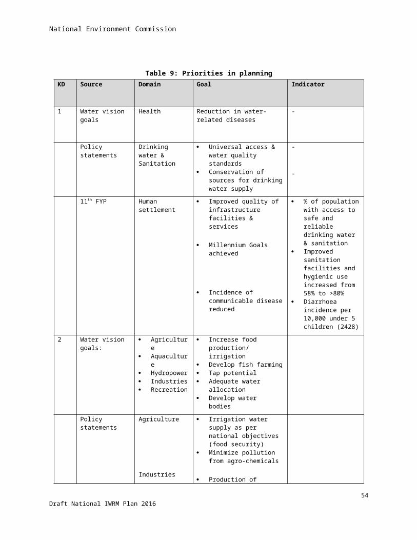
National Environment Commission
5 Bhutan Water Security Index
This chapter introduces the Bhutan Water Security Index that captures to what degree water resources and their related services are developed, measured over five key dimensions.
5.1 ConceptThe concept of water security index was introduced by Asian Development Bank (ADB) & Asian Water Development Outlook (AWDO) for Asia-Pacific water summit in 2007 in Japan. It meant to provide a broader perspective on water management than (traditional) sectoral approaches. It aimed at comparing the status of water management and its delivery services in a number of Asian countries.
It was revised in 2013 to include quantitative measurement, and to provide direction for governance, investments, capacity-building, monitoring/ reporting.
The concept was accepted for elaboration in Bhutan in a meeting of the Technical Advisory Committee in December 2014. The indicators were adapted to Bhutan conditions in a national IWRM workshop held in March 2015. The results of the workshop were endorsed by the TAC in May 2015. Slight modifications were approved by the TAC in November 2015 to make the BWSI more practical.
5.2 DescriptionADB vision of water security is as follows:
Societies can enjoy water security when they successfully manage their water resources and services to:
1. Satisfy household water and sanitation needs in all communities;
2. Support productive economies in agriculture, industry, and energy;
3. Develop vibrant, liveable cities and towns;
4. Restore healthy rivers and ecosystems; and
5. Build resilient communities that can adapt to change.
UN-water defines water security as “the capacity of a population to safeguard sustainable access to adequate quantities of acceptable quality water for sustaining livelihoods, human well-being, and socio-economic development, for ensuring protection against water-borne pollution and water-related disasters, and for preserving ecosystems in a climate of peace and political stability.”
5.3 Structure The water security index is composed of 5 key dimensions:
1. Rural drinking water supply, sanitation and hygiene
2. Economic water supply for agriculture, industries and hydropower
59Draft National IWRM Plan 2016
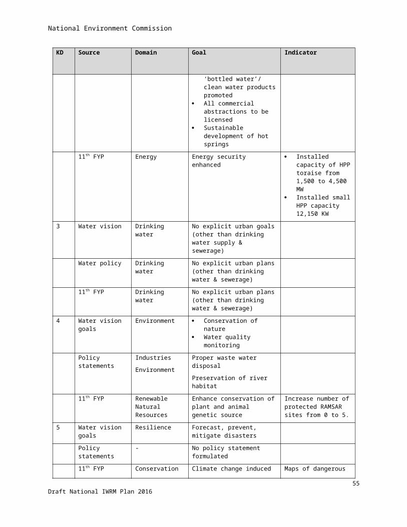
National Environment Commission
3. Urban water supply, sanitation and drainage
4. Environmental water security
5. Disaster and climate change resilience
Some key dimensions are directly calculated from a set of indicators. Other key dimensions are composed of sub-dimensions each containing a set of indicators. Indicators may contain more than one parameter, see table 11 below.
Table 10: Structure of the BWSIKey dimensions Sub-dimensions Parameters
1. Rural - 3
2. Economic 4 12
3. Urban - 5
4. Environment 4 12
5. Resilience 3 25
Total 5 11 57
5.4 ComputationA set of indicators has been developed for each of the five dimensions, which are designed to enable assessment of progress towards the goal of national water security. The indicators are then numerically aggregated into an index score for each dimension of water security. Water security in any given dimension is measured as an aggregate of the indicators for the component. The household water security index, for example, is an aggregation of three component indicators covering the extent of access to piped water supply, access to improved sanitation, and level of hygiene.
For each water security dimension, the resulting aggregated index is scaled from 1 to 530, where a score of 1 represents the lowest level of security, and 5 represents the highest level, as shown in table 12 below. By connecting the security index scores for each dimension, a pentagram can be derived—the size and shape of which is a good representation of the country’s water security, and which can be tracked over time in accordance with the evolving IWRM, and visualized as described in the next section.
30 NB: The values of the BWSI cannot be compared with those determined by AWDO because the calculation method is very different.
60Draft National IWRM Plan 2016

National Environment Commission
Table 11: Water security index stage and criteria (After AWDO, 2013)Index Stage Criteria
5 Model Sustainable financing for water security, environmental protection and management already established
4 Effective Water security is given high priority in the national agenda; appropriate public investment in water security; effective regulation and enforcement; public awareness and on-going behavioural changes apparent
3 Capable Increasing levels of investment and strength of regulation and enforcement; water security and environment recognized as priorities in the national development agenda; improving technical and financial capabilities in addressing water-related issues
2 Engaged Need to invest in water security recognized, including investment in capacity-building programs; on-going institutional development and strengthening; improving policy environment in which water-related issues are addressed
1 Hazardous Inadequate levels of investment in water-related infrastructure and poor quality regulation and enforcement result in hazardous levels of water security
5.5 VisualisationThe scores of the key dimensions of the water security index can be visualised in a spider web diagram as given in figure 18 below. The size and shape of the diagram are a good representation of the country’s water security, and can be tracked over time in accordance with the evolving IWRM spiral.
Figure 18: Visualisation of the score of the BWSI sub-dimensions.To be replaced with graph showing actual values
61Draft National IWRM Plan 2016
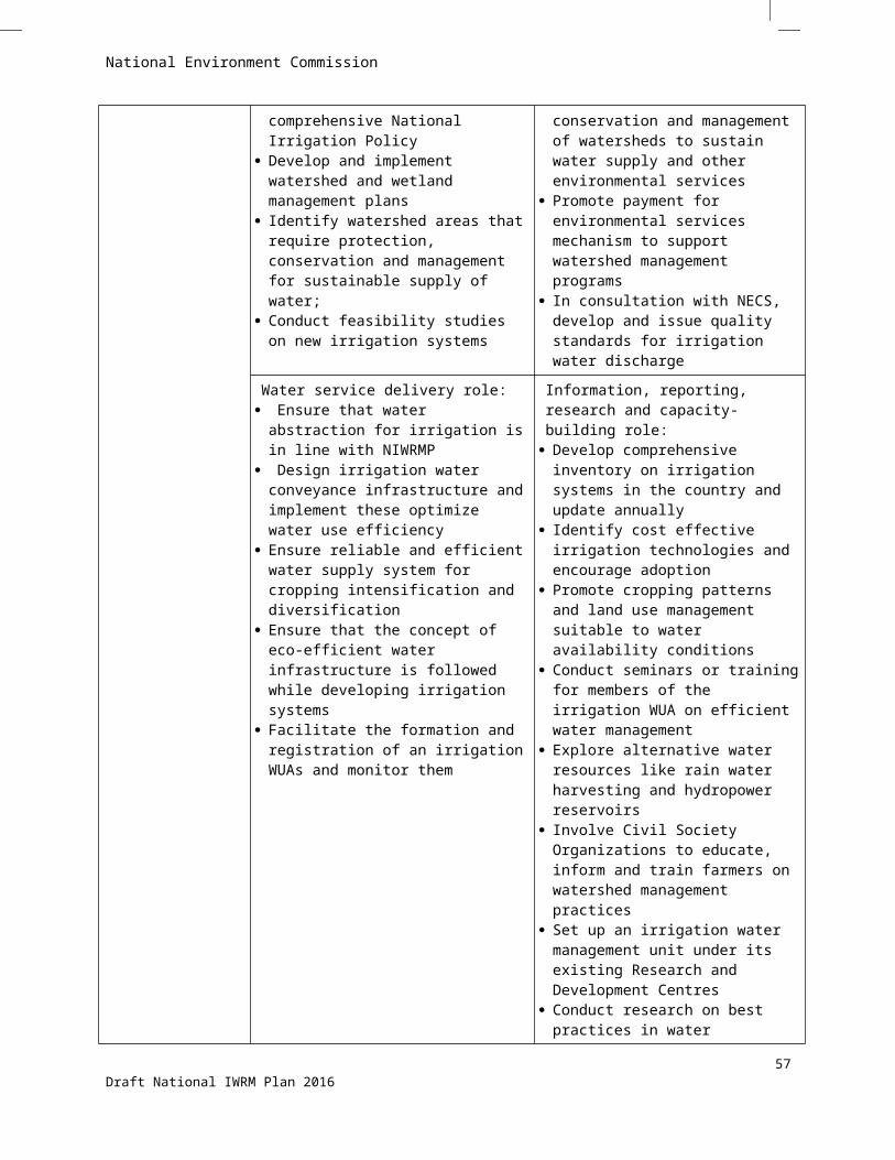
National Environment Commission
5.6 National and basin-level scores of the BWSI
The scores of the BWSI are given in table 13 below, forming the baseline for water security.
Table 12: National and basin-level scores of the BWSIKD\ Area Amochhu Wangchhu Punatsangchhu Mangdechhu Drangmechhu National
12345
OverallData are not yet available
62Draft National IWRM Plan 2016
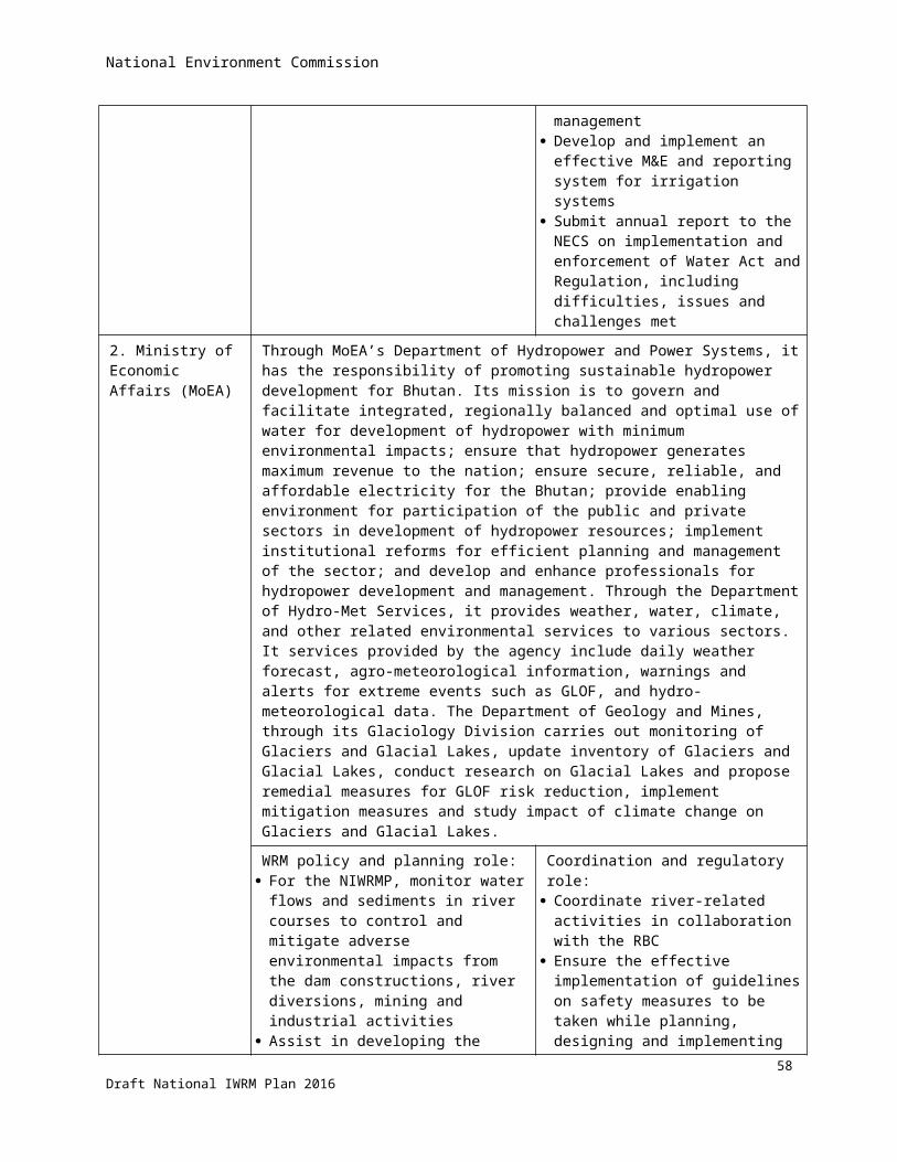
National Environment Commission
6 IWRM management framework at basin level
IWRM is applied at river basin level, hence the management framework at the basin level warrants a separate chapter. As such, some overlap with the general governance described in chapter 4 is inevitable. It starts with the delineation of the IWRM management basins. This is followed by a detailed description of the River Basin Committees to be formed, along with their roles and responsibilities, see also chapter 4.5. The chapter ends with a description of the River Basin Plans to be prepared.
6.1 Delineation of management basins for IWRMThe hydrological river basins have been described in section 2.6. From an administrative point of view it is not desirable to have too many basins, especially if 5 out of the 10 are quite small. Therefore, the basins are clubbed together into five management basins as presented in figure 19 and table 14 below. As can be seen, Amochhu has been grouped with Jaldakha; Punatsangchhu with Aiechhu, and Drangmechhu with Nyera-Amori, Jomori/Dhinsari, and Merak Sakteng. This seems at odd with the very principle of IWRM, but will reduce the number of new institutions (RBCs) to be established and hence also ease the coordination by NECS.
Figure 19: Delineation of river basins for IWRM planning and management
63Draft National IWRM Plan 2016
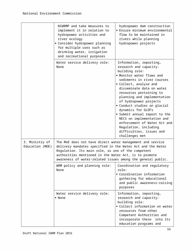
National Environment Commission
Table 13: Grouping of hydrological basins into management basinsManagement basin Hydrological basin Area
(km2)Annual flow (MCM)
1 Amochhu 1 Amochhu 2310 9,375.072 Jaldakha 942
2 Wangchhu 3 Wangchhu 4596 5,209.063 Punatsangchhu 4 Punatsangchhu 9645 19,129.79
5 Aiechhu 1937 6,989.144 Mangdechhu 6 Mangdechhu 7380 11,797.245 Drangmechhu 7 Drangmechhu 8457 13,569.14
8 Nyera Amari 23484,506.579 Jomori/ Dhinsari 642
10 Merak-Sakteng 137Total 38,394 70,576.01Flow in m3/s 2238
6.2 River basin committee and its functionsThe philosophy in designing Bhutan’s institutional set-up for IWRM, using a coordination model, is that it is not necessary (actually, not politically realistic) to aim for creating unitary basin organizations that take over the role of water resource management from existing administrative institutions, even as efforts continue to streamline the patchwork of such institutions. Standalone basin organizations would also be against the concept of cross-sectoral ‘integration’ and holistic views propagated by IWRM.
In IWRM, the river basin is the most logical unit for coordinated management of water resources e.g., for proper water resources accounting and allocation. The aim of coordination is to ensure that policies and programs in the basin—involving multiple actors and stakeholders--are characterized by minimal redundancy, incoherence, conflict and gaps.
The framework and functions have been elaborated based on guidelines in the Water Act and Regulation, and have been approved by NEC in their meeting held on 25 June 2015.
Composition of the River Basin Committee
According to the Water Act (Chapter 6, Section 27) , members of the committee may be drawn more broadly from Water User’s Associations or Federation of water Users’ Associations, hydropower generation agency, industries, drinking water supply and sanitation service providers, recreation and tourism operators, registered environmental non-governmental organizations, traditional communities with particular regard to those engaged in subsistence farming, and the Department of Forest and Park Services. However, following a recommendation of the IWRM Technical Advisory Committee (TAC) on the RBC composition, these other stakeholders need not be regular members of the committee so as to avoid overcrowding the RBC membership. Individual stakeholders shall be invited by the RBC during deliberation of matters relevant to the stakeholders’ specific concerns.
A representative of the NEC shall also serve as member of the RBC. The head of the Secretariat shall automatically serve as member-Secretary of the RBC. A diagram showing the structure of the River Basin Committee is shown in figure 20 below.
64Draft National IWRM Plan 2016

National Environment Commission
Figure 20: Diagram of the River Basin Committee
The RBC shall meet at least three times per year. Notices of meetings are to be sent out two weeks in advance, and one week in advance if the meeting is urgent. The required quorum for meetings is two-third of the RBC members. Two consecutive absences of an RBC member shall be grounds for reporting of such absence to the NEC. Committee members may send representatives to attend RBC meetings, but not for two consecutive meetings during the year. The RBC chairperson, upon advice of the Secretariat, may invite stakeholders to attend meetings if their participation is relevant to the meeting agenda. Reports to the NEC/NECS shall be submitted twice per year on the 30th of June and 31st of December.
Secretariat of the River Basin Committee
The RBC organizational option favoured was one in which a permanent Secretariat is to set up for each basin. NECS shall facilitate the setting up of the RBC Secretariats, and until such time that such bodies are formed it shall serve as the interim RBC Secretariat (initially for the Wangchhu basin, with support from the DEOs in the basin.
The functions of the RBC Secretariat will be assigned during an interim period (at least up to March 2016) to the NECS-WRCD. For the long-term, a dedicated secretariat is envisioned to be established for each river basin.
65Draft National IWRM Plan 2016

National Environment Commission
The secretariat shall prepare the meeting agenda for the basin committee, gather information needed to brief the committee on issues to be tackled, document proceedings, and consolidate the water plan for the basin (derived from the district and Gewog plans). As mandated by the RBC chairperson, the secretariat may summon representatives from the sectoral competent authorities to serve as resource persons. The latter shall give advice on technical matters, and ensure coordination of the basin plan with sector-level plans and programs for water resources development and management. The Secretariat will draw support from sectoral Competent Authorities on technical matters.
The RBC secretariat shall also act as an administrative support unit to the basin committee. It will be responsible for following through and monitoring implementation of measures authorized or directed by the basin committee; it will also work with the district and Gewog administrations to monitor water use/issues in the basin, including water infrastructure activities and related programs in the basin (in coordination with sectoral competent authorities). The DEOs of respective districts in the basin will assist in carrying out Secretariat functions.
Under the supervision of the RBC member-Secretary, the Secretariat shall perform the following tasks:
1. Assist the Chairperson of the RBC in preparation of annotated agenda of RBC meetings; draft minutes of the meetings and maintain records of RBC meetings.
2. Prepare and propose annual work plan and operational budget for the RBC, seek RBC approval and submit to WRCD, NECS for timely inclusion in the annual budget proposal.
3. Assist the RBC in applying the water security performance indicator system for the basin
4. Coordinate with the concerned district administrations and national sectoral agencies to ensure that basin plan items are being implemented
5. Advise the RBC in evaluating impacts of development plans or actions proposed by local administrations and national sectoral agencies operating in the basin
6. Assist the RBC in preparing water security and water-related reports to the NEC and GNHC
7. Facilitate conveyance of advisories or directives of the RBC to the district and Gewog administrations, as well as collate responses
8. In coordination with the NECS, maintain a water database for the basin, and coordinate the updating of information collected by local administrations and sectoral agencies operating in the basin
9. Establish a “knowledge hub” for matters pertaining to basin water resources management and coordination
10. Document successful IWRM interventions in the basin for reporting to the RBC, as well as dissemination to national policy-makers, stakeholders and the media
11. Facilitate networking and partnerships with NGOs, communities, state enterprises and private organizations operating in the basin
12. Identify needs and facilitate training and capacity building (with assistance from the NECS) among local administration staff on integrated water resources planning and management
13. Coordinate with the district and Gewog administrations to collect, compile, check, sort and analyse data about the status of water resources in the basin, and the on-going implementation of basin plans
14. Prepare necessary M&E forms and formats to collect data and information on the status of water resources and water security in the basin
15. Monitor performance of local administrations in implementing their assigned roles under the river basin plan, and report to the RBC
A proposed staffing of the basin Secretariat, which identifies positions and tasks, is provided in the RBC framework.
66Draft National IWRM Plan 2016
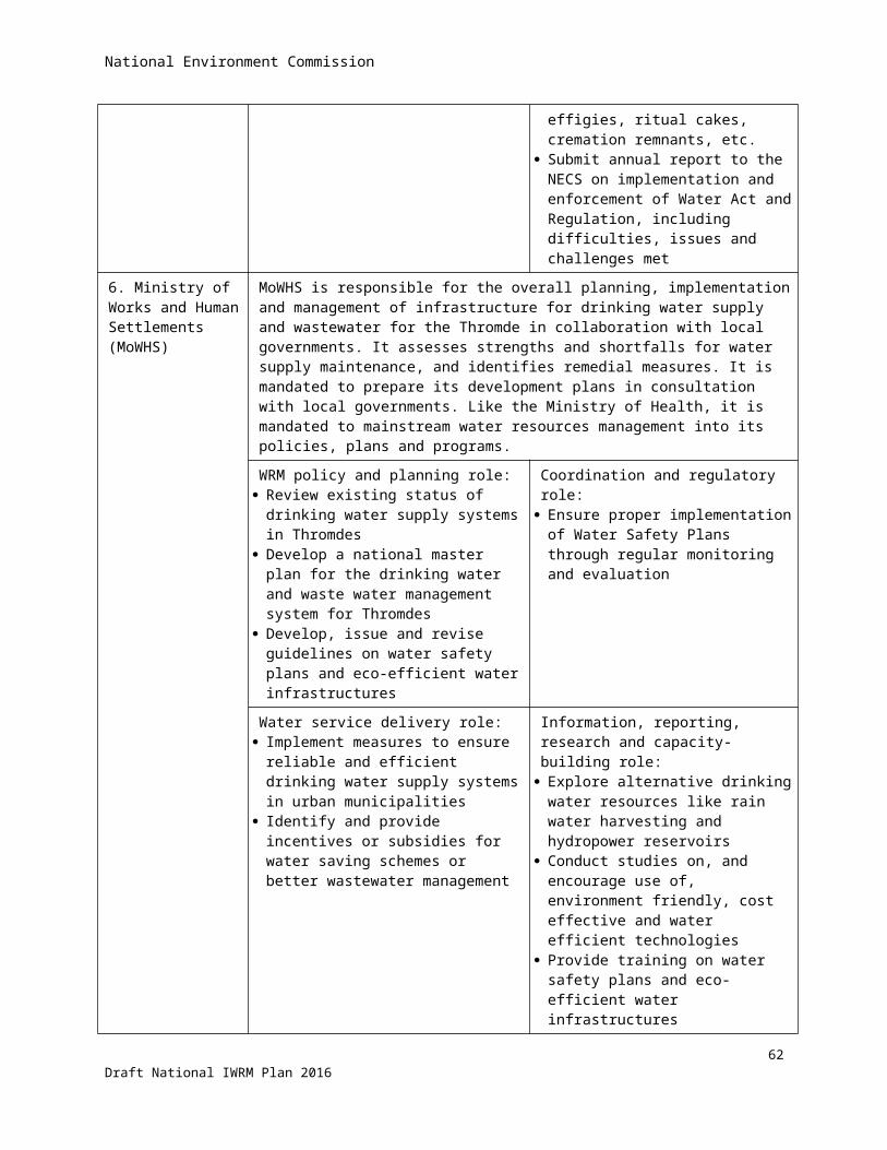
National Environment Commission
Functions of the River Basin Committee
With reference to the Water Act, the functions of the RBC are as follows:
1. To promote community participation in the protection, use, development, conservation, management and control of water resources in its area of operation through education and other relevant activities:
a. Formulate rules and procedures for the establishment and operation of community-level Water Users Associations
b. Promote and reward positive behavioural changes toward efficient water use and protection/maintenance of water sources
c. Raise community awareness on water-related issues, such as wasteful water consumption, unhygienic sanitation, improper disposal of solid and liquid wastes, water borne diseases, and environmental damage
d. Raise awareness on the various technical options of efficient water distribution and avoidance of losses
e. Encourage users to pay for water-related services within the scope of existing regulations
f. Promote adherence to directives from the RBC in resolving water-related disputes
g. Provide regular platform to inform and hear from stakeholders on matters related to water management in the basin
h. Develop and implement programs for local capacity-building in IWRM
2. To prepare a River Basin Management Plan together with the NECS
a. Assemble information required to prepare the basin plan
b. Consolidate water resources management plans prepared at the district level, including those of sectoral agencies involved in water management, and ensure that these are reflected in the basin plan (i.e., checking that the plans do not draw more water than is available)
c. Provide detailed specifications of programs and projects incorporated in the basin plan, including a proposed “responsibility framework” that identifies the appropriate level of plan implementation (i.e., by national agency or local administration)
d. Ensure that the basin plan is consistent with the principles and objectives of the National Integrated Water Resources Management Plan (NIWRMP), and that the water-related Key Result Areas (KRAs) and Key Performance Indicators (KPIs) incorporated in the GNHC’s medium term planning guidelines are reflected in the basin plan
e. Identify potential sources of funding for the proposed basin programs, including from international development assistance organizations, and develop proposals accordingly
f. Mobilize and allocate funds secured that are intended for implementing IWRM activities intended for the whole basin (i.e., programs identified through the RBC and covering multiple districts)
3. To monitor and report to the Commission on the effectiveness of policies and action in achieving sustainable management of water resources in its area of operation
a. Review the district-level integrated water use management and safety plans prepared by the respective Dzongkhag administrations based on the basin plan, and monitor their implementation for reporting to the NEC
b. Review the management/safety plans prepared by Class A Thromde Administrations in the basin to ensure efficient urban water supply and effluent disposal, including urban drainage systems,
67Draft National IWRM Plan 2016

National Environment Commission
and monitor their implementation for reporting to the NEC and the Ministry of Works and Human Settlements
4. To collect, manage and share such data as are necessary to properly manage the basin in coordination with the Commission
a. Establish baseline data on the water security indicators for the basin, following the framework set up by the NEC and GNHC for a national water security indicator system
b. Based on the basin plan implementation reports of the Dzongkhag and Thromde administrations, consolidate data to periodically update the water security indicators for the river basin, and report these to the NEC and GNHC, as well as to the basin consultative council
c. Facilitate the exchange of data and information among agencies operating in the river basin, and among the district and Gewog level administrations
5. To help resolve cross-sectoral and Dzongkhag trans-boundary issues relating to water resources in the basin
a. Serve as forum through which issues/disputes related to water sharing and distribution among districts within the basin can be discussed and resolved in an informed and consultative manner
b. Establish procedures/rules for hearing and resolving trans-boundary water allocation issues
c. Monitor and report to the NEC on adherence of parties to agreed trans-boundary water resources sharing
6. To perform any such additional functions as the NEC may direct, related to water resources management concerns in the basin.
6.3 River basin management plans
Preparation of the River Basin Management Plan
The preparation of the River Basin Management Plan follows from the Water Act 2011, which mandates NEC –supported by the River Basin Committee- to prepare such plan.
The Water Act states that: A National Integrated Water Resources Management plan shall be formulated for coordinated
development, management, conservation and efficient use of water resources.
The NEC-Secretariat, assisted by competent authorities, shall prepare and periodically update a River Basin Management Plans for each river basin.
The NIWRMP shall provide binding guidelines for the preparation of RBMPs
The Water Regulation adds that the Commission with the Competent Authorities will ensure that the NIWRMP is mainstreamed into national and sectoral policies, plans and programs for the efficient, effective and sustainable management of water resources, including watersheds and wetlands.
The Water Regulation mentions that the Commission will:
68Draft National IWRM Plan 2016

National Environment Commission
Designate major river basins for the purpose of preparing the RBMP for its implementation by respective Competent Authorities.
Establish River Basin Committees (RBCs) within a basin for the purpose of proper management of water resources and to enhance its economic values.
The Secretariat of the National Environment Commission shall:
Review and adopt River Basin Management Plans and forward them to the Gross National Happiness Commission for mainstreaming into national plans.
The Water Regulation states that the Secretariat shall:
Conduct an inventory of water resources;
Identify and demarcate the river basins;
Identify water resources for drinking, irrigation, energy, industry or other uses; and
Identify critical issues, gaps, and socio-economic concerns for the protection and conservation of water resources.
Contents of the River Basin Management Plan
The Water Act states that the RBMP shall contain at least the following elements:
Details of the water management area drawn from the NIWRMP;
Details on Flood Risk Zones and risk management plans;
Details on designated areas for habitat conservation and species directly depending on river water; and
A program for the monitoring of water status within the river basin area.
The Water Regulation adds that the RBMP shall contain the following elements:
Details of the water management area drawn from the NIWRMP;
Details on Flood Risk Zones and risk management plans;
Details on designated areas for habitat conservation and species directly depending on river water; and
A program for monitoring of water status within the river basin area.
Maps of the location and boundaries of water bodies;
Compilation of water related baseline data;
Maps of watershed areas of the river;
Maps of monitoring networks;
Maps of human settlements;
Maps of agricultural land use;
Hydropower generation plans;
Hydropower integration with respect to watershed management;
69Draft National IWRM Plan 2016
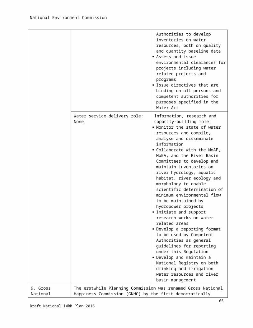
National Environment Commission
Impacts of human activity on the quality and quantity of water resources;
Identification of both point source and non-point source pollution;
Analysis of social and health impacts;
An economic analysis of water, in particular, those with potential for competing use;
Mechanisms to control water abstraction and discharges in relation to permits and environmental clearances issued;
A summary of the public consultation.
Measures to prevent deterioration of water bodies, limit or control water pollutants; and
Measures to enhance and restore polluted or depleted water bodies.
Role of the River Basin Committee
According to the Water Regulation, the functions of RBC will include the following:
Promote community participation in the protection, use, development, conservation, management and control of water resources in its area of operation through education and other appropriate activities;
Prepare a River Basin Management Plan for the basin; Monitor and report to the Commission on the effectiveness of policies and action in achieving sustainable
management of water resources in its area of operation; Collect, manage and share such data as are necessary to properly manage the basin in coordination with
the Commission; Help resolve cross-sectoral and Dzongkhag trans-boundary issues relating to water resources in its area of
operation; and Perform any such additional functions as the Commission may direct.
70Draft National IWRM Plan 2016

National Environment Commission
7 Priorities in the national IWRM program
The IWRM spiral illustrates IWRM as an incremental, step-by-step process, and therefore provides a practical framework for looking ahead and planning for successive ‘turns of the spiral’ thereby gradually achieving improved status and management of the water resources. From among all water-related activities touched upon in the NIWRMP, the following priorities are given in the IWRM program.
7.1 Adoption of water security as concept for coordination in IWRM planning and monitoring
It is proposed that the concept of water security will be adopted as National Key Result Area in the GNHC planning process for preparation of successive Five Year Plans. This National Key Result Area is elaborated in the form of 5 objectives, 57 indicators and numerous strategies for the preparation of river basin management plans as set out in chapter 5. The decision to adopt water security as KRA in the national planning process may be taken before the end of the 11th FYP.
7.2 Delineation of agency roles in operationalizing the BWSI The BWSI has been developed as a tool for coordination of agencies, whereby different agencies take responsibility for specific indicators of the BWSI. This delineation of responsibilities is given in appendix 2, and needs to be formalized by the Government when adopting the BWSI concept.
7.3 Delineation of river basins for integrated water resources management
For the purpose of integrated water resources management, it is proposed that the rivers in Bhutan will be grouped into the following management basins, as was shown in figure 19 above.
i. Amochhu with Jaldakhaii. Wangchhu
iii. Punatsangchhu with Aiechhuiv. Mangdechhuv. Drangmechhu with Nyera-Amari, Jomari/ Dhinsari, and Merak-Sakteng
It should be realised that combining a main north-south river with independent minor basins into one management unit has implications for the functioning of the River Basin Committee – when applying the principle of subsidiarity. Subsidiarity is an organizing principle that matters ought to be handled by the smallest, lowest or least centralized competent authority. Political decisions should be taken at a local level if possible, rather than by a central authority.[1] The Oxford English Dictionary defines subsidiarity as the idea that a central authority should have a subsidiary function, performing only those tasks which cannot be performed effectively at a more immediate or local level.
71Draft National IWRM Plan 2016

National Environment Commission
Hence, the RBC of a composite basin may have sub-committees for the minor basins operating under the full basin committee.
The decision on clustering of river basins for IWRM may be taken before the end of the 11th FYP.
7.4 Re-alignment of administrative boundaries along hydrological units
IWRM shall be implemented at the level of river basins, but planning and implementation of measures is, and remains to be done through the district administrations. Since there is a mismatch between administrative boundaries and hydrological units, some districts are in two (or more) basins. This amounts to double work for the district administration, since they will be represented in all basins of which they are part.
It is therefore proposed to re-align administrative (district and Gewog) boundaries along hydrological boundaries, as shown in figure 4 above. The re-alignment of administrative boundaries along hydrological boundaries may be completed by the end of the 12th FYP.
7.5 Ratification of the framework and functions of the RBCThough the framework and functions of the RBC have already been endorsed by NEC in the meeting of 25 June 2015 (as explained in chapter 6), its immediate ratification is included in the priority recommendations.
7.6 Preparation of successive RBMPsIn line with the stipulations in the Water Act it is proposed to draft River Basin Management Plans for Amochu, Punatsangchhu, Mangdechhu, and Drangmechhu basins.
The sequence and time horizon of preparation of RBMPs may be based on the baseline values of the basin-level BWSI, but could also be guided by political considerations such as equal opportunities for the basins, or addressing most problematic areas first.
7.7 Strengthening the capacity of NECS
Given the increased work load for NECS with respect to coordination of planning and monitoring of IWRM, it is proposed to strengthen its staff as described below. The details and terms of reference of proposed staff are given in the stand-alone report.
To keep momentum in IWRM, and for its effective implantation, the proposed increase in capacity of NECS may be implemented by the end of the 11th FYP.
72Draft National IWRM Plan 2016
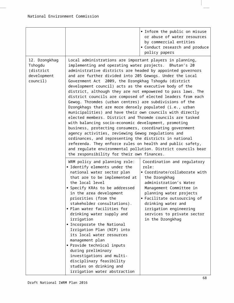
National Environment Commission
Strengthening Coordination Mechanism
This will require the WRCD, NECS to enhance its coordination role whereby it should create platform for players to cooperate and interact systematically plan, implement, maintain and update information, and report. For this, the WRCD shall be re-organised and strengthened into three major sections:
1) Coordination Section catering to:
i. Develop and apply framework for Water Security Indicator system for Bhutan
ii. Facilitate a common platform for planning and implementation of the National IWRM plan based on the water security framework.
2) Research and Capacity Building section whose tasks are to:
i. Provide research services by collecting, collating, and analysing sectorial information and publish periodical water security index (preferably at Gewog, district, and national level);
ii. Develop and update water quality standards for different sectors
iii. Conduct orientation/training for district environment officers and basin committee secretariats on assessment and monitoring of water resources and water security.
3) Monitoring section with the function of assisting the NECS to:
i. Monitor performance of government agencies with mandates under the Water Act towards the delivery of KRAs, measured through their corresponding Key Performance Indicators (KPIs)
ii. Coordinate with the GNHC on water-related aspects for the National Monitoring and Evaluation System (NMES), in particular on the M&E set-up and the operation of the web-based Planning and Monitoring System (PLaMS) to incorporate key water security indicators (adopted in the GNHC planning guidelines).
iii. Coordinate with the basin committees/secretariats to collect, compile, check, sort and analyse qualitative and quantitative data about the status of water resources and the on-going implementation of basin plans and district/Gewog level activities.
The organogram is presented in figure 21 below. As can be seen a total of 10 new posts will be created. More details are given in the stand-alone document on Governance.
73Draft National IWRM Plan 2016

National Environment Commission
Figure 21: Organogram of sections proposed under the WRCD
7.8 Strengthening the capacity of the Department of Agriculture
For effective implementation of the NIMP, it is proposed to increase the capacity of DOA along the lines described below. It may be realized by the end of the 11th FYP.
Main Interventions
1. Strengthening of the existing Irrigation Management Section at the central office with establishment of three sub-units, as depicted in Figure 22 below. The will comprise of one coordinator and two officers in each unit, in total adding 9 staff.
74Draft National IWRM Plan 2016
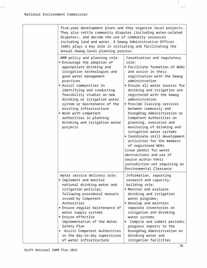
National Environment Commission
Dept. of Agriculture
Engineering Division
Irrigation & Water Mgnt Section
Project Implementation Unit
Planning & Design Unit
Monitoring & Info Mgnt Unit
Building & Infrastructure Section
Rural Road Section
District Engineering
Units
Regional Development
Centres
Central Machinery Unit
Agricultural Machinery Unit
Figure 22: Proposed sub-units under the Irrigation and Water Management Section of the DOA
2. Establishment of Irrigation Water Management Units at the DoA regional development centres to facilitate research on best practices for water management in irrigation systems.
The 2014 Water Regulation called for setting up of irrigation water management units under the three Research and Development Centres. Specifically, the regulation mandated MoAF to "institute an irrigation water management unit under its existing Research and Development Centres (RDC) to facilitate and support irrigation development. “Currently, however, there is only an average of three DoA Engineering Division staff posted in each of the three RDCs. Setting up an irrigation management unit in each RDC, with at least 2 personnel assigned to the unit, entails adding 6 staff to the Engineering Division. Moreover, it is proposed to align the jurisdiction of the Research and Development Centres to the boundaries of river basins.
The details of the proposals are elaborated in the stand-alone document of Governance.
7.9 Strengthening the weather and hydrological monitoring and forecasting capacity
It is proposed to improve the functions of the DHMS as outlined below during the course of the 12 th FYP.
Improvement of weather and discharge monitoring stations
DHMS should be able generate hydro-meteorological information that is sufficiently detailed to represent smaller geographical units (districts and Gewogs) throughout the country. Presently, 92% of the stations cover only about half of the country’s land mass, i.e., areas below 3,000-meter elevation. The higher elevations are thus significantly under-represented.
75Draft National IWRM Plan 2016
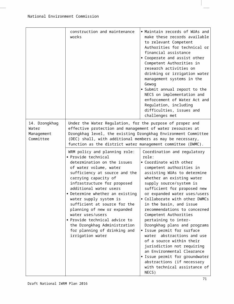
National Environment Commission
Based on the WMO’s guidelines regarding density of meteorological stations, a mountainous country like Bhutan should have precipitation gauges for every 250 square kilometres (or approximately 15 km apart, on average). This translates to 150 such stations to cover the country, which is roughly 60% higher than the present station density.
Expanding the meteorological network to adequately cover elevations above 3,000 meters is important due to the projected increase in precipitation with latitude (particularly in Bhutan’s mid-zone), and associated with the shift of the snow line northward because of warming.
DHMS as broad service provider
It is proposed that DHMS will in future provide hydrological and meteorological information to other sectors than hydropower, such as NEC (for IWRM) and Agriculture.
The current location of the DHMS within the MoEA has drawn concern as to whether, under such organizational set-up, the department is in an effective position to fulfil that role. This issue should be further examined, preferably alongside the dialogue with sector agencies and public stakeholders, as part of an overall institutional development and capacity strengthening.
One option is to delink the DHMS from the MoEA and establish it as a standalone service bureau, a precedent for which exists in Bhutan’s national statistical bureau.
7.10 Training planIt is proposed to implement a training plan for government staff as summarised in table 15 below.
76Draft National IWRM Plan 2016
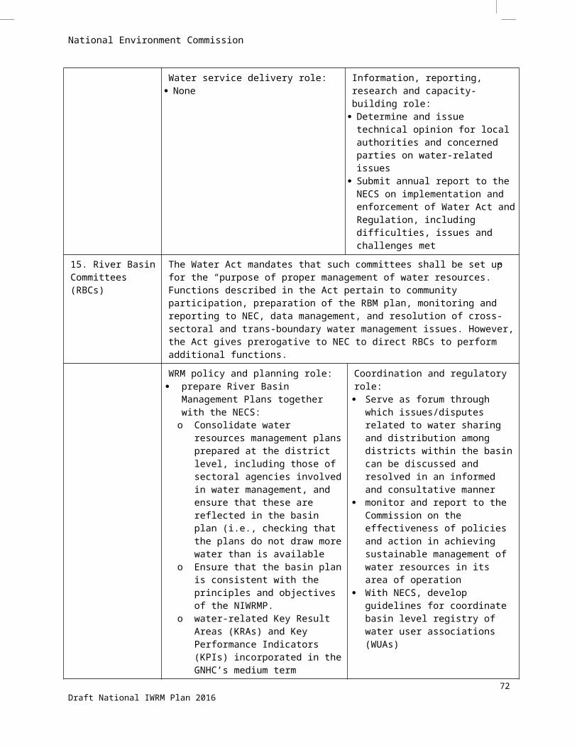
National Environment Commission
Table 14: Training plan
Short term in-country group training workshops and refresher coursesType of Training Topics Participants/ Relevant agencies Schedule Est. Budget (US $) Logistic Requirements
IWRM principles and practices
- IWRM history/rationale;- IWRM principles and practices;- Multi-disciplinary/stakeholder context of IWRM;- River basin as basic unit for IWRM;- Conducting water resources inventory;- IWRM planning and implementation steps.
NECS, GNHCS, MoAF, MoEA, MoE, MoH, MoHCA, MoWHS, CSOs, Dzongkhag Tshogdu, Gewog Tshogde, District Water management Committees, RBCs, WUAs.Target: 30
Once every Five Year
Plan period for each
river basin
25000 WRCD, NECS to prepare training plan in consultation with GNHCS, identify venue and relevant in-country resource persons.
IWRM Planning and Coordination in Bhutan
- Bhutan Water Act and Regulations;- Bhutan's IWRM Coordination set-up;- Planning: Water Security performance
benchmarking and indicators (KRAs and KPIs); - Results-based monitoring and evaluation (M&E)
frameworks.
NECS, GNHCS, MoAF, MoEA, MoE, MoH, MoHCA, MoWHS, CSOs, Dzongkhag Tshogdu, Gewog Tshogde, District Water management Committees, RBCs, WUAs.Target: 30
Once every Five Year
Plan period for each
river basin
25000 WRCD, NECS to prepare training plan in consultation with GNHCS, identify venue and relevant in-country resource persons.
Bhutan Water Security Index System
- Water security indicator system and updates if any;- dimensions and indicators of water security;- baseline and targets;- uses for planning and monitoring;- IT-based application: online data entry; - analysis and information sharing.
NECS, GNHCS, MoAF, MoEA, MoE, MoH, MoHCA, MoWHS, CSOs, Dzongkhag Tshogdu, Gewog Tshogde, District Water management Committees, RBCs, WUAs.Target: 30
Once every Five Year
Plan period for each
river basin
25000 WRCD, NECS to prepare training plan in consultation with GNHCS, identify venue and relevant in-country resource persons.
Regular study tour and participation in water events and forumsType of Training Topics Participants/ Relevant agencies Schedule Est. Budget (US $) Logistic Requirements
Participation in global and regional Water forums and conferences
Global Water Forums- World Water Forums- Stockholm Water Week- Netherlands Water Learning Week
WRCD, NECS staff (2) and selected focal persons of competent Authorities (3)
Annually 15,000 - WRCD, NECS to plan, form and lead delegation;- inclusion of stakeholder in delegation; - identify funding.Regional Water Forums
- India Water Week- Singapore Water Week- ADB Water Week
WRCD, NECS staff (2) and selected focal persons of competent Authorities (3)
Annually 15,000
77Draft National IWRM Plan 2016

National Environment Commission
Type of Training Topics Participants/ Relevant agencies Schedule Est. Budget (US $) Logistic Requirements
Study tour Study tour for selected members of the Wangchhu Basin Committee
Selected members of Wangchhu RBC (Total 14)2016
2016 32000
Long term degreesType of Training Topics Relevant agencies Proposed
slotsEst.Budget
(US $)Doctoral Degree Climate and hydrological modelling College of Science and Technology 1 130,000
Climate and hydrological modelling Sherubtse College 1 130,000Agriculture and Irrigation systems in mountain areas College of Natural Resources 1 130,000
Master Degree Modelling and Information Systems for Water Management. Proposed topics are:
- Managing uncertainty in climate projections; - Global & regional climate change (CC) issues; - Interpreting climate change projections; - CC vulnerability & impact assessment; - Hydrological impact analysis; - Delineating watershed boundaries; - Assessing water availability in ungauged basins
WRCD, NECS; DHMS, MOEA 2 140,000
Land and Water Development for Food Security. Proposed topics include:
- Assessing crop water requirements; - On-farm water management
DOA, MOAF 1 70,000
Hydraulic Engineering and River Basin Development. Proposed topics include:
- Conducting irrigation engineering surveys; - Designing irrigation and drainage structures
Engineering Division, DOA, MOAF;DES, MOWHS; NECS
2 140,000
Flood Risk ManagementProposed topics include:
- Flood risk assessment and forecasting;- Flood zonation mapping;- Flood prevention and management measures
FEMD, DES, MOWHS; DDM, MOHCA 2 140,000
Ground water hydrologyProposed topics include:
DHMS, MOEA; DGM, MOEA 2 140,000
78Draft National IWRM Plan 2016
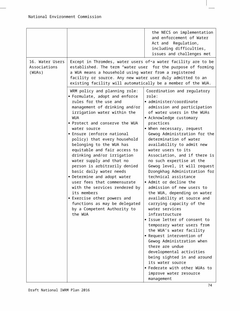
National Environment Commission
Type of Training Topics Relevant agencies Proposed slots
Est.Budget (US $)
- ground water assessment- technologies in ground water abstraction
Water, Sanitation and Health engineeringProposed topics include:
- Assessing domestic water requirements- Water quality monitoring
PHED, MOH; WSD, DES, MOWHS 2 140,000
Soil, water and Environment managementProposed topics include:
- Assessment of ecosystem services- Watershed delineation and classification- Watershed management- Soil and water conservation
WMD, DOFPS 1 140,000
79Draft National IWRM Plan 2016

National Environment Commission
7.11 Formalisation and strengthening of Water Users Associations
WUA recommendations
According to the 2014 Water Regulation (Chapter III), WUAs are expected to formulate and enforce their own rules for managing water sources, and for protecting the sources themselves. This non-rigid approach already reflects the observations that customary water management arrangements and non-codified community rules are already effective in managing irrigation water allocations and system maintenance, including conflict resolution.
The customary practices may be effective as long as the irrigation systems remain traditional. However, if an external intervention to support an expansion or modernization of irrigation development is envisioned, as proposed in the NIMP, the establishment and operation of WUAs may need to be more formalized and codified. This is especially true if organized irrigators desire in future to tap micro-financing (e.g., from the Bhutan Development Bank) to procure farming equipment or inputs. This is because the legal entity of the WUAs would enable them to take loan or financial assistance from other sources.
Furthermore, there are new expectations on WUA roles that are stated in the 2014 Water Regulation (Chapter III, Section 36). Notable are two expanded functions: (i) determine and adopt water user fees that are commensurate with the water services rendered, i.e. the fees can be charged based on the acreage, decimal or square feet. The fees can also be differentiated between the dry land, wet land and other activities which require water and (ii) exercise other powers and functions as may be delegated by a Competent Authority within the jurisdiction of the WUA, which in this case could be the district administration and the River Basin Committee.
AS per the Regulation, WUAs are expected to become more involved in coordinating with local administrations and basin water authorities, thereby extending its role beyond that of coordinating water allocation and collection of fees. For instance, WUAs are to serve as the channels for requesting the Gewog or Dzongkhag administrations to provide technical assistance in determining water availability, which will be used as basis for admitting new water users (e.g., in cases where the irrigation system is being expanded), or as basis for allowing non-irrigation water uses (e.g., livestock water use), and as basis for water sharing when water supply is scarce. WUAs shall also be the formal channel through which intervention by the Gewog administration would be sought in cases where “undue” development activities are encountered that pose a threat to the water source and its catchment (e.g., riverbank and watershed disturbances).From time to time, the WUAs may need to invite resource persons from the local area administrations (e.g., district forest officer, district rural engineer) to attend WUA meetings in order to provide technical support or advice.
One of the coordination tasks of WUAs under the 2014 Water Regulation is that of federating with other WUAs to improve water resource management, in particular within the context of integrated catchment or basin management that aims to minimize upstream and downstream water use conflicts. Federating WUAs would also be necessitated by the possible consolidation of adjoining irrigation systems as part of the system modernization or rehabilitation.
In the course of managing the water use for irrigation, empowered WUAs would increasingly serve as the venues for deciding on water allocations (during periods of water scarcity or high water demand) and for resolving water disputes. At present, water disputes have to be brought to the attention of the Gewog chief for resolution. As
80Draft National IWRM Plan 2016
National Environment Commission
envisioned in the Water Regulation, WUAs could appoint one or more negotiation facilitators to settle disputes amicably, and if necessary render a decision by casting votes among the WUA members.
Other expected roles of WUA as mandated by the Water Regulation are to (i) decide on punitive actions for members failing to comply with the standing rules of the association; (ii) hear and decide on disputes among its members relating to water and infrastructure use; (iii) take necessary measures to ensure efficient use of water, and (iv) employ or appoint water guards; the so-called CHHU SUP.
Administrative roles of WUA are also being expanded, including (i) keeping records of irrigable land holdings among WUA members; (ii) maintaining records of minutes of meetings and decisions taken; (iii) maintaining books of accounts on money received (e.g., from user fees) and disbursements made, and (iv) submitting reports and exchanging information with the WUA federation.
Given these expectations on the expanded role of WUAs, in particular for the irrigation system water associations, institutional capacity building is needed to equip both existing and newly formalized associations to fulfill such roles. Since it is the DoA that has an important stake in ensuring that the irrigation systems it establishes or modernizes are operated efficiently and sustainably, it should incorporate such capacity-building component in its planning and execution of irrigation development projects.
Based on findings from social survey and field assessments, the following are the important elements that should be incorporated in the DoA’s capacity-building component for WUAs strengthening (starting with an updating of the DoA WUA manual) to support the national irrigation master plan:
• Developing a platform for the community to act in unison and not individually
• Providing inputs and developing wider understanding of the Water Act, Policy and Regulations
• Provide support for IEC on water management
• Develop community level rules and roles for water management
• Divide and delegate roles to members in keeping vigil and protection and eco-maintenance of the water sources
• Develop mechanisms for linking up with other WUAs and authorities at various levels
• Develop mechanisms through Gewogs and Dzongkhags to federate and provide representation in RBCs For many WUAs there would be more than one RBC to relate with
• Develop ways and means to communicate and document concerns, suggestions and recommendations in RBCs
• Merging water management needs into local level (Dzongkhag and Gewog) development plans and onward merger with plans of central agencies responsible for the sectors
• Developing local level management budgets and methods of pooling resources
81Draft National IWRM Plan 2016
National Environment Commission
The RBCs are responsible for coordinating water allocations in the basin. To that effect RBCs shall:
• Establish and update guidelines for water allocation
• Set procedure for registration of WUAs
• Develop a template for registration
Based on the above, the Gewogs shall:
• Process the applications for registration of WUAs.
• Maintain an inventory of WUAs, their allocated abstraction amounts, and the purpose of abstraction
Framework for WUAs registration System
It has been examined whether the responsibilities of Water Users Associations (WUAs) under the Water Act of Bhutan, 2011 (Water Act) and the Water Regulation of Bhutan, 2014 (Water Regulation) are adequate in fulfilling the aims and objectives of the National Integrated Water Resource Management Plan and over all plans and policies of the government in the management of water in the country.
In this regard, the focus is on the requirement of elaborate conditions and procedures for the registration of WUAs including the requirement of registration application forms and formats, which would enable the relevant authorities to properly regulate the WUAs as per the Act and Regulation. The proper management of WUAs will also formalize the existing WUAs and will encourage the formation of new WUAs. The established system will provide the legal entity to the WUAs, which will build confidence and relationship amongst the people at grass root level, who are the end users and beneficiaries of laws, policies and s of the government. The uniform systems will also bring peace and harmony in the society, which is important in fulfilling the principles of Gross National Happiness.
On reviewing the Water Act, it is established that the provisions are provided in broad terms which is a typical approach in drafting laws. The practical requirement of implementing the Act is done by providing the detail procedures in the rules and regulations or in the guidelines. In this regard, on the review of the Water Regulation mainly in the context of the functions of the WUAs, it is established that the said issues are elaborated too summarily and there is no proper system and procedure for regulating WUAs.
Therefore, it is important to update and expand the Water Regulation either by amending the Regulation or by developing a guideline, which would provide detail procedures and forms for the registration process. For example, section 51 and 52 of chapter 11 of the Water Act and rule 22 to 35 of the Regulation provides that any water users within a vicinity using the water from the common water source or facility for the water supply is required to form Water Users Associations for the promotion of present and future water security interest. As per section 51 of the Water Act, any WUAs shall be registered with the Competent Authorities (CA) within six months of its formation.
Although, the Regulation has identified the Gewog Administration as the authority for registering the WUAs, it does not provide detail provisions and process of registration. Therefore, for practical purpose it is important to develop proper forms and format for the registration of WUAs along with such other terms and conditions related to registration process.
82Draft National IWRM Plan 2016
National Environment Commission
Due to the inclusion of forms under the Regulation, the relevant provisions of the Regulation are updated accordingly by proposing certain changes by means of modification, deletion or addition, so that the forms acquire legitimacy of its usage.
The additional provisions and the forms will accordingly establish a dispute mechanism procedure; which will give the affected parties an opportunity to appeal if not satisfied with the decision of the registrar or any competent authorities.
Registration of WUAs
As per section 50 of the Water Act, any group of beneficial using a particular water source for their water supply needs may form a Water Users Association to maintain the water source and to manage water supply services. Such WUAs shall be registered with the Competent Authorities within six months from the date of its formation. The necessary documents for the registration of proposed WUAs will be prepared by the Chairperson of WUA and the office bearers with the technical assistance of the relevant Competent Authorities, which will contain name and address of the WUAs, name of the Chairperson and office bearers, list of the water users, length of the flow volume of the water, date of construction of the water facility, name and location of irrigation or drinking water source, whether the Association is for irrigation, drinking water or both for any commercial purpose.
The registration has to be applied by the Chairperson of the WUA with the concerned Gewog Administration. In case the water users comprises from two or more Gewogs, the Association will be registered with the Gewog Administration that has majority users. On the satisfaction of the Gewog Administration, the Registrar will issue a certificate of registration under the sign and seal of the Gup. The copy of the registration certificates and a list of registered WUAs maintained with the Gewog Administration will be sent annually to the Dzongkhag Administration with a copy to the relevant Competent Authorities for updates. Any change in the information of the Association will have to be informed to the concerned Gewog Administration within three months of such changes for necessary updates in the records of the Association.
For the purpose of registration procedures different forms are developed which are added as annexures to the Water Regulation as follows:
Form No. 1 is for the purpose of submitting an application for registration of WUAs to the Registrar of the Gewog Administration, which will provide all the details of the WUAs including the constitution or memorandum of agreement of WUAs. It will also contain the minutes along with the names and signature of the founding members. The form will be duly signed by the Chairperson of the WUAs.
Form No. 2 is for the purpose of submitting the notice of change of constitution or memorandum of agreement and other details of WUAs, which is important for updating the information by the Gewog Registrar. This is important to avoid future complication when it comes to the interpretation of the role of the concerned WUAs. It will be signed by the chairperson of WUAs and filed before the Registrar of the Gewog Administration.
Form No. 3 is regarding the notice of refusal to issue a certificate of registration to a WUA by the Registrar of the Gewog Administration where the WUA has not fulfilled the criteria as provided under the Water Regulation. It also allows the concerned WUA to appeal before the Dzongkhag Administration within 15 working days from the date of the notice of refusal, if not satisfied with the decision.
83Draft National IWRM Plan 2016
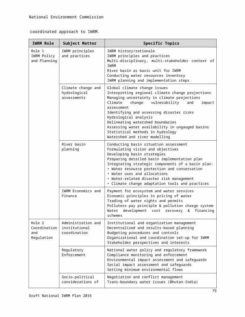
National Environment Commission
Form No. 4 confers a right to WUA to notify the Registrar of the Gewog Administration of its intention to appeal against the decision of the refusal to issue certificate of registration. In such a case WUA has to provide the justifications for the appeal and can appoint a representative to represent the WUA before the Dzongkhag Administration.
Form No. 5 is for the purpose of issuing a Certificate of Registration. It will contain all the details of the WUA including name, address, sources of water and area of operation along with general and specific conditions.
Form No. 6 is for the purpose of suspending or cancelling the registration of a WUA by the Registrar of the Gewog Administration for not complying with the terms and conditions of the certificate of registration.
Form No. 7 is developed for the purpose of notifying the Registrar when the concerned WUA has changed its constitution or the office bearers. This is mainly for the purpose of updating the information and avoiding future complications.
Apart from the above forms many other relevant forms can be developed in the future depending on the need and relevancy and accordingly the Regulation or Guideline has to be updated for compliance.
7.12 Improvement and harmonisation of the legal framework for IWRM
The Water Act 2011 is the first act to address water resources in an integrated manner. Until then, management of water resources was fragmented, addressed in different laws, and only focused on the operational level. The Water Act is an important milestone in the implementation of the concept of IWRM in national legislation. It is also in line with the national concept of Gross National Happiness. The issues provided for in broad terms in the Act, are elaborated in more detail in the Water Regulation 2014.
It is recommended to monitor the implementation of the new legal framework during the plan period of this NIWRMP, particularly with respect to the issues identified in section 4.2. The NECS should guide this monitoring process in line with its overall coordination role. The yearly reports of the water-related institutions at all government levels are in important input for the collection of information about the implementation of the Water Act and the Water Regulation. In addition, the NECS can initiate other activities such as workshops with the relevant stakeholders with the goal to create consensus about issues that need further improvement in the legislation. Based on that it will become clear which issues can be sufficiently solved through amending only the Water Regulation, and which issues are of such an importance that they need to be solved at the level of the Water Act itself.
Another point is concerned with the relation between the Water Act and other water related acts. It is important that the Water Act and the water-related acts (as well as their underlying implementing regulations) are sufficiently harmonized to avoid overlaps, contradictions or gaps. The overall conclusion of a desktop assessment carried out in 2015, is that the Water Act and the existing water-related acts (and regulations) are in harmony. Most issues are addressed in the acts consistently, though in some cases there are ambiguities that may cause confusion – as stated in section 4.2. On-going initiatives to revise the concerned water-related acts (such as the Electricity Act) can be used to solve the ambiguities.
84Draft National IWRM Plan 2016
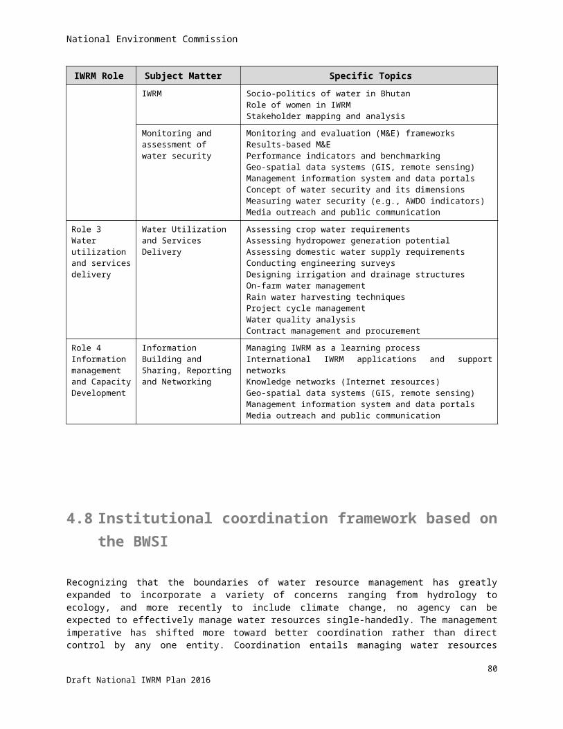
National Environment Commission
85Draft National IWRM Plan 2016
National Environment Commission
Selected references
Stand-alone documents produced in 2016 by ADB-CDTA Bhu-8623: Adapting to climate change through IWRM:
I. Hydro-meteorological data projections for Bhutan based on CMIP5 scenariosII. Hydrological modelling and water resource assessments
III. National irrigation master planIV. Assessment of legal framework for IWRMV. GIS and database management
VI. Bhutan water security indexVII. Social aspects of IWRM, a field survey
Bajracharya et al. 2014. The status and decadal change of glaciers in Bhutan from the 1980s to 2010 based on satellite data. Samjwal Ratna BAJRACHARYA, Sudan Bikash MAHARJAN, and Finu SHRESTHA. Annals of Glaciology 55(66) 2014 doi: 10.3189/2014AoG66A125
Bhutan Renewable Natural Resources Statistics 2015
Data collection survey on renewable energy in the Kingdom of Bhutan, JICA-DRE MoEA, 2013
Eleventh Five Year Plan 2013-2018, RGOB
Global water partnership: http://www.gwp.org
Inventory of Glaciers, Glacial Lakes and Glacial Lake Outburst Floods, Monitoring and Early Warning Systems in the HKH Region ( Bhutan). Pradeep K. Moool, Dorji Wangda, Samjwal R. Bajracharya, Karma Kunzang, Deo R.Gurung and Sharad P. Joshi. ICIMOD, Kathmandu, Aug 2001.
National accounts statistics 2014
Rapid classification of watersheds in the Wangchhu basin, SNV-WMD, DOFPS, MOAF, 2011
Statistical yearbook of Bhutan 2014
UN-Water: http://www.unwater.org
86Draft National IWRM Plan 2016
National Environment Commission
Appendices to this report
87Draft National IWRM Plan 2016
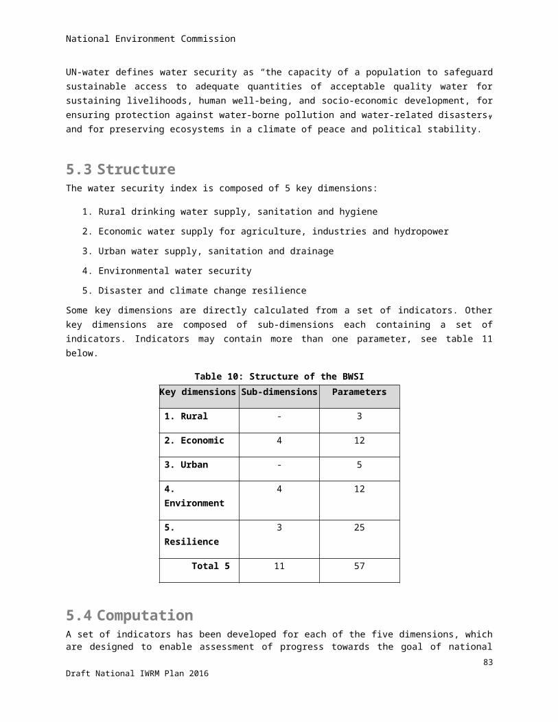
National Environment Commission
Appendix 1: Areas in basins and districts
Percentage of district in the basins, and percentage of basins in the districts
Districts Area (Sq.Km) Total% of district % of basin % of district % of basin % of district % of basin % of district % of basin % of district % of basin % of district % of basin % of district % of basin % of district
Thimphu 1792 81.2% 31.7% 18.8% 3.5% 100%Gasa 2951 100.0% 30.7% 100%Punakha 1110 100.0% 11.5% 100%Wangdue Phodrang 3977 74.3% 30.7% 26.1% 13.6% 100%Tsirang 638 100.0% 6.6% 100%Dagana 1713 4.0% 1.5% 95.2% 17.0% 0.8% 0.7% 100%Trongsa 1814 100.0% 23.8% 100%Bumthang 2667 100.0% 35.0% 100%Zhemgang 2416 87.2% 27.6% 12.8% 3.6% 100%Lhuentse 2851 100.0% 33.4% 100%Monggar 1940 100.0% 22.7% 100%Trashi Yangtse 1447 100.0% 17.0% 100%Trashigang 2198 58.1% 15.0% 41.9% 32.9% 100%Pema Gatshel 1022 69.2% 8.3% 30.8% 15.9% 100%Chhukha 1,880 63.3% 25.9% 36.7% 21.2% 100%Haa 1,905 31.0% 12.9% 69.0% 40.3% 100%Paro 1,287 100.0% 28.0% 100%Samdrup Jongkhar 1,877 100.0% 67% 100%Samtse 1,256 100.0% 38.5% 100%Sarpang 1,655 100.0% 83.4% 100%
Area / % 38395 4592.0 100.0% 9618.8 100.0% 7625.1 100.0% 8531.0 100.0% 3259.5 100.0% 1983.9 100.0% 2797.4 100.0%
Wangchhu Punatsangchhu Mangdechhu Drangmechhu Amochhu Aiechhu Nyera Amachhu
88Draft National IWRM Plan 2016
National Environment Commission
Appendix 2: IWRM planning and coordination framework based on the BWSI, and responsible agencies
Introduction The NIWRMP should be seen as a framework with tools for the purpose of water-related planning and coordination. More concrete planning shall be done through the river basin management plans for which the NIWRMP aims to provide guidelines.
Goal, objectives and strategiesGoal of the National IWRM plan is to achieve water security for Bhutan. This is to be accomplished by better coordination between the water users and key agencies that are managing the water resources. The Bhutan Water Security Index is the mechanism proposed to be used for the envisaged coordination in planning and management. In other words, it is proposed that the BWSI will be adopted as National Key Result Area in addition to the 16 KRAs that have already been defined under the planning mechanism established under the Gross National Happiness Commission. The BWSI has 5 Key Dimensions, which would translate into 5 Sectoral Key Result Areas that would be added to the 300 Sectoral Key Result Areas that are already in use in the FYPs.
Hence, the objectives of the NIWRMP are based on the key dimensions of the BWSI. They correlate with the Sectoral Key Result Areas in the FYPs and their compliance is measured by indicators. The KRAs and indicators are mostly self-explanatory but will be briefly explained below.
The strategies explain how the objectives of the key dimensions would be realized. A number of strategies will be mentioned for each Key Dimension, but the list is not meant to be exhaustive. Some duplication is unavoidable.
Key Dimension (Objective/ KRA) 1Improve and protect the drinking water supply, sanitation and hygiene in rural areas
KD1 assesses the extent to which rural household water and sanitation needs are met, and improved hygiene for public health is provided in all communities. It is a composite of three main sub-indices (i) access to piped water supply (%), (ii) access to improved sanitation (%), and (iii) hygiene (incidence of diarrhoea per 10,000 people).
Indicators
1. Percentage of population with piped potable water supplyThis indicator is self-explanatory
2. Percentage of population with improved (sealed) sanitationAs above, this indicator is self-explanatory
89Draft National IWRM Plan 2016

National Environment Commission
3. Incidence of diarrhoeaDiarrhoea is an infectious disease that is related to hygiene and thus related to proper sanitation. It is expected that the incidences of diarrhoea will reduce when a larger part of the population is using proper (sealed) sanitation.
Strategies Improve the condition of catchment areas and water sources (reforestation and conservation measures)
Improve access to alternative drinking water sources (water harvesting, groundwater development)
Move human settlements on hill slopes to lower elevations (for better water supply)
Improve management and maintenance of rural water supply systems (strengthen Water Users Associations)
Carry out health campaigns (public awareness)
Key Dimension (Objective/ KRA) 2Maximize the economic benefit of water resources in a sustainable way
Water is an essential input to grow food and fibre, for many industrial processes, and to generate the energy required by society. The use of water in these sectors is increasingly recognized as closely related and can no longer be addressed in isolation from each other. Debate about the water-food-energy nexus has begun to raise general awareness about the critical interaction among water uses to support economic activities.
Economic water security measures the productive use of water to sustain economic growth in the food production, industry, and energy sectors of the economy. The indicators are aggregates of multiple sub-indicators, defined to highlight key aspects of water security in a particular sector as described in the following sections. There is debate (also in AWDO) to what extent the indicators are applicable at basin level – beside national level.
Sub-dimension 2A1 – Agriculture resilienceResilience refers to the ability to cope with the adverse effects of rainfall variability. Recognizing that agricultural water use is vulnerable to rainfall variability31 and that water storage constitutes a viable method to mitigate the effects of that variability, a first indicator focuses on these two key issues.
Indicators
1. Percentage of cropped areas irrigated from reservoirsRain-fed agricultural production is susceptible to the weather conditions. The larger percentage of cropped areas can be irrigated from reservoirs, the less vulnerable the agricultural production is supposed to be.
31 Other water uses are vulnerable to rainfall variability as well. Given the greater role of water in agriculture and that agriculture, after the environment, is usually the residual water user, agriculture can be considered particularly vulnerable.
90Draft National IWRM Plan 2016
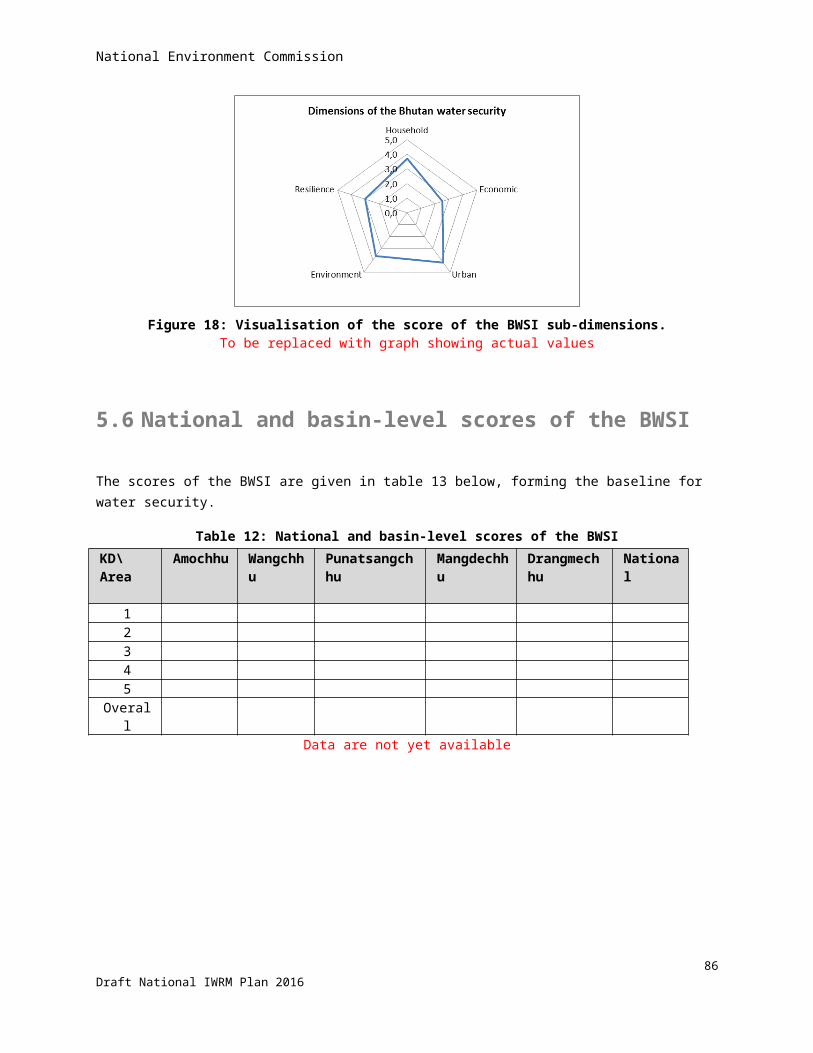
National Environment Commission
2. Variability of inter-annual rainfallAgricultural production depends on rainfall and/ or irrigation. The larger the variation of rainfall over the years, the more vulnerable it is. Rainfall cannot be planned as such, but adaptive measures for highly vulnerable areas can be planned for. That is why this indicator has been adopted.
3. Variability of intra-annual rainfallAs mentioned above, agricultural production depends on rainfall and/ or irrigation. The larger the variation of rainfall within a year, the more vulnerable it is. Rainfall cannot be planned as such, but adaptive measures for highly vulnerable areas can be planned for. That is why this indicator has been adopted.
Strategies Increase number/ volume of water retention structures Groundwater exploitation Adopt agricultural adaptation measures (water-efficient crops, increase water use efficiencies)
Sub-dimension 2A2: Agriculture water utilization efficiencyThe water utilization efficiency is defined as a function of agricultural water productivity, and proportion of arable land irrigated. To characterize the productivity of water use in irrigated agriculture, we considered the monetary value per unit of water in agriculture, and the percentage of arable land that is irrigated.
Indicators
1. Agricultural contribution to GDPObviously a higher contribution of (irrigated) agricultural production to GDP is desirable.
2. Percentage of arable land irrigatedA higher percentage of cultivable land being irrigated will contribute to higher overall agricultural production as well as reduction of poverty
3. Percentage of cereal consumption that is imported out of the total cereal consumptionThis indicator has an inverse appraisal: lower volumes of cereal imports mean higher self-sufficiency is achieved in line with the national policies.
Strategies Crop diversification/ high-value crops Increase irrigated areas Increase agricultural water-use efficiencies
91Draft National IWRM Plan 2016
National Environment Commission
Sub-dimension 2B – Industrial water securitySimilar measures as above were applied to industrial water use. However, the number of indicators used for industry is smaller than for agriculture. The reduced number of indicators reflects both the reduced proportion of water claimed by industrial uses as well as the relative dearth of data related to water and industry. Our water-industry indicator has only one indicator and focuses on water productivity in industry.
Indicator
1. Revenue generated from water-based industries in million Nu/ MCM (productivity)Like for agriculture, a higher contribution of (water-based) industries to GDP is desirable.
Strategies Expand water-based clean industries Shift to high-value production
Sub-dimension 2C - Hydropower water securityGiven the direct linkages between water, hydropower, and energy supply in a country, this sub-dimension directly focuses on hydropower. The indicators focus on the dependence of hydropower on trans-boundary inflow into Bhutan, the proportion of a country’s technically exploitable hydropower capability that has been tapped, and the relative contribution of hydropower to a country’s energy supply, and the plant load factor that indicates how efficiently the turbines are used.
Indicators
1. Percentage of volume of trans-boundary inflow compared with total annual flow (internal renewable water resources + incoming water)Hydropower generation is to some degree dependent on inflow from China in Amochhu and Drangmechhu basins, leaving Bhutan vulnerable. This aspect is monitored in this indicator. It has an inverse appraisal: the lower the value, the more secure is hydropower generation.
2. Percentage of potential hydropower installedThe RGOB aims at high development of hydropower, which is monitored by this indicator.
3. Percentage of hydropower contribution to total energy consumptionA high percentage of hydropower in total power consumption indicates less use of fuel wood or fossil fuel, and is in line with RGOB policy.
4. Hydropower revenue (in million Nu per amount of water used in MCM (productivity)Like for agriculture and industries, the contribution of hydropower to GDP is monitored.
92Draft National IWRM Plan 2016
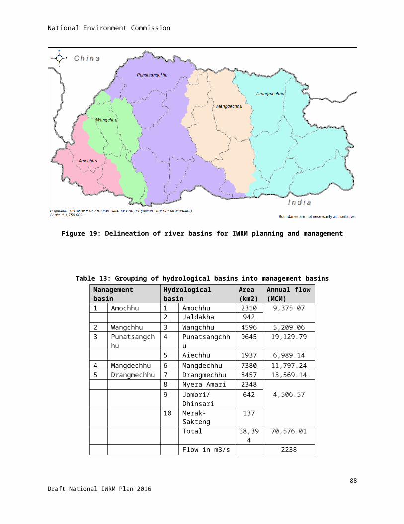
National Environment Commission
5. Hydropower efficiency as weighted average annual plant load factorThe plant load factor indicates how efficiently the generators are being used, or how effectively the river flows are used for hydropower generation. This is monitored by this indicator.
Strategies Increase hydropower development Conservation of catchment areas to dampen seasonal flow variation and to reduce sediment load of the
water (both expected to worsen under climate change) Increase number and volume of water retention structures/ reservoirs to dampen seasonal flow variation
and to reduce sediment load of the water
Key Dimension (Objective/ KRA) 3Improve and protect urban drinking water supply, and improve effectiveness of urban sanitation and drainage
The urban water security indicators measure the creation of better water management and services to support vibrant and liveable water-sensitive cities. A water-sensitive city is defined as a city that integrates water supply, sewage, storm-water, and the built environment; a city that respects the value of urban waterways; and a city where citizens value water and the role it plays in sustaining the economy, environment, and society (Brown, Keath, and Wong 2009).
The urban water security index is a composite of four sub-indices relating to water supply coverage, wastewater treatment, garbage collection (to keep water ways clean) and urban flooding.
Indicators
1. Percentage of urban population having potable piped water supplyThis indicator is similar to the one applied for rural drinking water supply and is self-explanatory.
2. Percentage of urban water loss (un-accounted for)This indicator monitors the difference between the amounts of water delivered to the households and paid for, as compared to the amounts pumped into the system. Obviously, the difference should be minimized.
3. Percentage of urban population with improved sanitationThis indicator is similar to the one applied for rural areas and speaks for itself.
4. Percentage of urban population with (at-least weekly) waste collection and disposal serviceWhen solid waste is not properly collected and disposed of, it will often end-up in the open water ways and spoil the quality of the water. This aspect is more pronounced in urban areas, where solid waste collection and disposal can be more efficiently organized than in thinly populated rural areas.
5. Damage from urban floodingMonsoon floods can damage economic assets and property, particularly when drainage is inadequate and/or when the water ways or drains are eroding their banks. The flood dame is monitored by this indicator.
93Draft National IWRM Plan 2016

National Environment Commission
Strategies Improve the condition of catchment areas and water sources (reforestation and conservation measures) Improve access to alternative drinking water sources (water harvesting, groundwater development) Improve design, maintenance and management of urban water supply systems (strengthen responsible
agencies) Water metering and pricing Improve urban drainage systems Remove settlements from flood-prone areas Improve solid waste collection and disposal services Carry out public awareness campaigns (for health, hygiene, and O&M of water supply & sanitation
systems)
Key Dimension (Objective/ KRA) 4 – Environmental water securityConserve watersheds and reverse degradation that has already occurred
Rivers have become vulnerable to pressures from pollution, diminished flows, watershed deterioration, and increasing populations and industrial activities. The environmental water security indicator assesses the health of rivers and measures progress on restoring rivers and ecosystems to health on a national and regional scale. The environmental water security index is composed of four themes – watershed disturbance; pollution; water resource management; and biotic factors.
Sub-dimension 1 – Watershed disturbanceThe watershed disturbance theme captures the local-scale impact of land-use change and poor stewardship within catchments. Drivers include (i) conversion from natural land cover to cropland; (ii) construction of impervious surfaces; (iii) degradation of uplands and riparian zones by livestock; and (iv) disconnection of floodplains from rivers.
Indicators
1. Fraction of cropland relative to total areaConversion of natural land cover to cropland often increases the rainfall runoff and erosion, particularly in steep sloping areas like mostly occur in Bhutan. Thus, this aspect has a negative appraisal from environmental point of view.
2. Fraction of impervious layer relative to total areaSimilar to above, built area like houses, roads, parking places tend to increase the rainfall runoff and have disturbing impact on the watershed.
3. Livestock densityFree roaming cattle have a disturbing impact on the watershed by trampling and compacting the soil, browsing the vegetation and thus increasing rainfall runoff and erosion. The cattle population density is a measure to monitor this effect.
94Draft National IWRM Plan 2016

National Environment Commission
4. Fraction of natural wetland relative to total areaNatural wetlands have an important function in the watersheds in terms of their buffering effect on water flow, and natural cleaning effect of water quality, and providing habitat for a range of organisms and species. Economic development often goes at the expense of natural wetlands by draining them (and convert them into built or agricultural areas) or by cutting them off from the rivers. This type of watershed disturbance is monitored by this indicator.
Strategies Watershed conservation programs, particularly in areas marked as ‘critical’ Reduce the loss of natural watershed areas to the extent possible (under economic development) Control drainage and erosion from disturbed land surfaces Environment-friendly road construction Control number of livestock that is roaming free (by stable feeding) Protect natural wetlands Control forest fires Control (illegal) logging
Sub-dimension 2 – PollutionThis sub-dimension encompasses a number of pollutants that have well known direct or indirect effect on water resources and/ or bio-diversity. Indicators include (i) soil salinization; (ii), nitrogen; (iii) phosphorus; (iv) mercury deposition; (v) pesticide loading; (vi) sediment loading; (vii) organic loading (as Biological Oxygen Demand, BOD; (viii) potential acidification; (ix) thermal alteration. As can be seen below, not all these drivers have been adopted in the BWSI.
Indicators
1. Total suspended solids in ppmThe sediment load in the rivers is a factor to be considered in hydropower generation. Sediments are detrimental to the turbines and should settle in stilling basins that are included in the design of the hydropower plant.
2. Organic loading/ BOD5Biochemical oxygen demand is a measure of pollution in terms of the amount of dissolved oxygen utilized by microorganisms during the oxidation of organic components in the water. After incubation, the amount of dissolved oxygen consumed is obtained by titration and the results expressed as parts per million of BOD. Complete biological oxidation generally requires about 20 days at 68°F. However, the test has been standardized to be completed in 5 days, hence the term BOD5. BOD can be used as a gauge of the effectiveness of wastewater treatment plants.
Strategies Watershed conservation programs to control run-off and erosion, and to keep sediment loads in the
water down Expand and improve coverage of sewage treatment
95Draft National IWRM Plan 2016

National Environment Commission
Draft/ enforce regulations relating to pollution
Sub-dimension 3 – Water resource managementThe Water Resource Development sub-dimension includes a variety of ways in which people have altered the quantity of water available to human populations and providing essential ecosystem services. Indicators include (i) the density of dams within catchments; (ii) the fragmentation of river networks by dams; (iii) consumptive water loss; (iv) human water stress; (v) agricultural water stress; (vi); and (vii) flow disruption.
Indicators
1. Dam densityDams in rivers disrupt the free movement of migrating fish species. The reservoirs change the temperature of the water as well as the sediments load. These factors have an impact on the environment. Therefore the density of dams in the river system is an indicator for water resources management. A high value has a low appreciation.
2. River length de-wateredThis aspect relates to run-off-the river hydropower plants, whereby the river flow is diverted through the so-called head race tunnel to the generators of the power plant. This practice leaves the river bed with a fraction of the original water flow, particularly when environmental flow requirements are not met.
3. Dependable Water availability per capita during lean season (January)The amount of water available per capita is a measure of water resource management. In Bhutan, this figure is only meaningful during the height of the lean season, which is January.
4. Relative total water consumption during lean season (January)The percentage of available water used for consumption is an indicator for water stress. The irrigation demand is low in January. A high percentage has a low appreciation.
5. Relative total water consumption during peak irrigation demand (May)The domestic and industrial consumptive water use is believed to be fairly constant over the year. But irrigation water demand varies strongly over the months within a year. Peak irrigation demand occurs in May, when land is prepared for transplanting paddy and the monsoon rains are only just starting. Like for total (drinking) water consumption in January, total (irrigation) water demand as percentage of available water is an indicator for water stress in May.
Strategies Maintain ecological flows Plan water-consuming activities (urban centres, irrigation and industries) in those areas where water
availability is good Reduce water demand (increase water-use efficiency, water-efficient crops, etc.) Improve water balance assessments (better quality and coverage of climatic and stream flow data)
96Draft National IWRM Plan 2016
National Environment Commission
Sub-dimension 4 – Biotic factorsThis theme aims to capture the local and spatially-distributed impacts of changing the biota of river ecosystems. Humans have altered riverine faunas in many ways. Specific drivers include (i) the percentage of non-native fish species; (ii), number of non-native fish species; (iii), fishing pressure; (iv) and aquaculture pressure. Each of these drivers has a variety of detrimental effects on fresh waters, ranging from changes in the loading and cycling of nutrients to destabilizing food webs to altering species interactions. Since fishing and aquaculture play a minor role in Bhutan, these factors are not included in the BWSI.
Indicators
1. Number of non-native fish speciesThe number of foreign fish species is monitored.
2. Percentage of non-native fish speciesThe percentage of foreign fish species is also considered since it puts the number of foreign fish species in a context.
Strategies Monitoring of fish (aquatic) species
7.13 Key Dimension (Objective/ KRA) 5 – Disaster and climate change resilience
Reduce socio-economic loss resulting from (climate change induced) water-related disasters, particularly GLOFs, landslides, and monsoon floods/ droughts.
There is an increasing global consensus on the importance of water-related risk management. Risk management requires quantification of water-related disaster losses at a finer temporal and spatial resolution than currently available for the analysis of trends. Such analysis will provide estimates of vulnerability and resilience and allow assessment of the effectiveness of mitigation policies and investments. The BWSI focuses on: i) Hazards and threats; ii) Sensitivity to exposure; and iii) Coping and adaptive capacity.
The complexity of assessment of water-related disasters is such that the computations of the resilience indicators are the most complex in the AWDO water security index. In fact, these could not be replicated and therefore the BWSI uses a simple linear scoring.
NB: Many of the phenomena captured in the indicators below cannot be planned as such, but their implications can be planned for. That is why the following indicators have been adopted in the BWSI.
Sub-dimension 5A – Hazards and threats Disaster risk (R) is defined as an indicator of expected disaster damage per capita, taking into account the likelihood of occurrence and likely severity. Likelihood of occurrence is not measured by a strict joint probability of
97Draft National IWRM Plan 2016

National Environment Commission
hazard occurrence and vulnerability but by a statistical average of hazardous phenomena, such as an area’s average daily maximum precipitation. Hence, a hazard is a potentially damaging physical event, phenomenon, or human activity that may cause the loss of life, injury, property damage, social or economic disruption, or environmental degradation.
Indicators
1. Maximum total one-week precipitation during the yearExtreme high rainfall is an obvious threat and potential cause of disaster; hence it is used as an indicator.
2. Inventory of hazardous GLOF lakesGlacial Lakes at risk of having an outburst flood are also a threat. An inventory of such lakes is used as an indicator for assessing resilience.
3. Frequency of rainfall > 100 mm/dayA high frequency of high rainfall events is indicative for risk of flooding.
4. Maximum number of consecutive dry days (< 1 mm/day)Prolonged periods of drought form the opposite risk of flooding, but put a high demand on management of the water resources. Hence, drought periods are an indicator in the BWSI.
Strategies Strategies for adaptation to extreme weather events Update inventory of GLOFs and design/ implement mitigating measures Improve weather forecasting system (expand/ improve weather and flow monitoring stations) Design/ implement early warning systems for floods Water retention/ infiltration structures Drainage improvement/ river training works
Sub-dimension 5B – Sensitivity to exposureExposure relates to the people, property, systems, or other elements present in the area that may be affected by a hazard or threat.
Indicators
1. Dry-land (Kamzhing) as percentage of total areaA high percentage of dry-land of total area means that much of the agricultural land is dependent on rainfall, which amounts to a sensitivity.
2. Percentage (annual) change in forest cover over the last 5 yearsThis indicator measures the rate of de-forestation and the related increase in runoff and erosion.
98Draft National IWRM Plan 2016
National Environment Commission
3. Deviation from constitutionally mandated forest cover (60%) at national and basin levelThis indicator monitors the deviation from the mandated forest cover as a measure of sensitivity to extreme weather events.
4. Population densityObviously, a high population density is more sensitive to exposure to extreme weather events than a low population density.
5. Urban population densitySame as above
6. Urban population growth rate (Thromdes)Same as above
7. Total population growth rateA fast growing population is more sensitive to exposure to extreme weather conditions than a stable population.
Strategies Watershed conservation and re-forestation Water retention/ infiltration structures Move human settlements away from flood/ drought-prone areas
Sub-dimension 5C – Coping and adaptive capacityCoping relates to the ability of dealing with disaster in terms of preparedness and/or mitigating measures. Adaptive capacity is the ability to adjust to a changing environment. The indicators are mentioned below.
Indicators
1. GovernanceNumber of basins with functional RBCs with:
Secretariat formed RBMP prepared or under implementation At least one RBC meeting held /year
2. Poverty ratePoor communities are less capable of coping with disasters and adverse conditions. Hence poverty rate is adopted as an indicator in the BWSI.
3. Child mortality rate (0-5).The child mortality rate is a considered as an (inverse) proxy for the vitality of the population. With higher child mortality, the population is weaker and thus less adaptive to adverse conditions.
99Draft National IWRM Plan 2016
National Environment Commission
4. Net official development assistance as percent of gross national incomeWith high development assistance, the community is expected to cope better with disaster.
5. Establishment of (effective) Emergency Response MechanismsRGOB policy aims at establishing emergency response units in each district. This indicator monitors the progress.
6. Reservoir capacityReservoirs will dampen runoff waves in the rivers, hence a high reservoir capacity is a good way to buffer the peak flows.
7. Flood/ drought hazard zonation maps produced and updatedMaintaining updated maps of flood hazard zones is a good way of coping with flood risk.
8. Number of (identified) flood protection measures pending for implementationThis indicator assumes that the area is relatively safe from flooding if the identified flood protection measures have largely been implemented, so there are few remaining to be done. (NB: The number of flood protection measures implemented does not always mean that the area is safe!)
9. Number of flood/GLOF Early Warning Systems pending for implementationSimilar as above
10. Literacy ratioLiterate communities will be better able to cope adverse conditions because their higher level of understanding, but also because they can be informed more easily (by radio, TV, mobile phone) on what to do or not to do.
11. Education level of women for enhanced coping capacity (with CC impacts)Similar to above. Women can direct households/ children in case of adverse conditions. A better education will enable to better cope with this task.
12. Access to information – TV, radiosTV and radio are important means to inform communities about what actions to take.
13. Access to Information – mobile phonesSimilar as above.
14. Gross domestic savings relative to GDPA larger amount of savings will enable communities to cope better with adverse conditions by investing in the necessary mitigating/ adaptation measures.
Strategies Formation and strengthening of River Basin Committees Formulation/ updating/ implementation of (comprehensive) river basin management plans Re-align district and Gewog boundaries to match hydrological boundaries Pursue economic development (in sustainable way) Improve reach/ effectiveness of emergency response mechanisms Increase number/ volume of water retention/ infiltration structures
100Draft National IWRM Plan 2016
National Environment Commission
Maintain updated flood/ drought hazard zonation maps Expand/ improve early warning systems Identify/ implement flood mitigation measures Pursue literacy and general education Promote access of communities to TV, radio, and mobile phones Reserve emergency funds
101Draft National IWRM Plan 2016
National Environment Commission
Parameters of the BWSI and agencies responsible
Key Dimension Parameter Agency responsible for data
KD-2 ECONOMIC WATER SECURITY KD-2A1 Agriculture resilience
1 % of cropped area irrigated from reservoir MoAF/DoA/Dzongkhag (DAO)/2 variability of inter-annual annual rainfall DHMS, MoEA3 variability of intra-annual rainfall DHMS, MoEA
KD-2A2 Agricultural water utilization 1 Agricultural productivity - contribution to GDP in Nu/ MCM DOA, MoAF2 % Arable land irrigated DOA, MoAF3 Amount of cereals imported out of cereals consumed (MT) MoA /RMA
KD-2B Industrial water security 1 Revenue generated from water based industries Dept. of Industry, MOEA
KD-2C Hydropower water security 1 Percentage annual national trans-boundary inflow DHMS 2 % of potential hydropower capacity installed DHPS, MOEA/ DRE, MOEA3 % hydropower contribution to total energy consumption DHPS, MOEA/ DRES, MOEA4 Hydropower contribution to GDP in million Nu/ MCM DHPS / DRE5 Hydropower Efficiency (weighted average annual plant load factor) DHPS
KD-3 URBAN WATER SECURITY 1 % of urban population having potable water supply- Urban Water and Sanitation Division, DES, MoWHS2 urban water losses Water and Sanitation Division, DES, MoWHS3 % of population without improved sanitation Water and Sanitation Division, DES, MoWHS
4 % of urban population with at least weekly solid waste collection and disposal service Water and Sanitation Division, DES, MoWHS
5 Damage from urban flooding/ capita / GDP per capita Flood Engg Mgmt Div., DES MoWHSKD4 ENVIRONMENTAL WATER SECURITY
KD-4A Environment - Watershed disturbance 1 Fraction of cropland (considering DoA, MoAF
102Draft National IWRM Plan 2016
National Environment Commission
2 Fraction of impervious surface area. DoA, MoAF3 Livestock density. DoL, MoAF4 Natural Wetland status. WMD, DOFPS
KD-4B Environment - pollution 1 Total suspended solids. DHMS2 Organic loading/ BOD NOP, DOA, MoAF
KD-4C Environment - Water resources management 1 Dam density DHPS, MoEA and DRE, MOEA
2 Percentage of the length of main and primary river(s) dewatered (for Hydropower) DHPS, MoEA
3 Relative total water consumption in the lean period - January WSD, DES4 Relative total water consumption in the lean period - May WSD, DES
KD-4D Environment - Biotic factors 1 Number of non-native fish species. National Fishery Centre, MoAF2 % non-native fish species
KD-5 DISASTER & CLIMATE CHANGE RESILIENCE KD5A Hazards and Threats
1 Maximum total one week precipitation (millimetre) DHMS2 Inventory of Potential hazardous lakes for GLOF Risk DGM, MOEA3 Frequency (>100 millimetre/day rainfall) per year DHMS4 Number of consecutive dry days (< 1 millimetre rainfall) DHMS
KD5B Sensitivity to exposure 1 Dry-land (Kamzhing) area as percentage of total area DoA, MoAF2 Percentage change in forest cover over the last five years DOFPS, MOAF
3 Deviation from constitutionally mandated forest cover (60%) at national and basin level DOFPS, MOAF
4 Population density (numbers per Km2) NSB5 Urban Population density NSB6 Urban population growth rate (Projected based on 2005 baseline data) MOWHS/ NSB7 Total population growth rate (projected) NSB
KD5C Coping and Adaptive capacity
103Draft National IWRM Plan 2016
National Environment Commission
1 Governance NEC2 Poverty Rate NSB 3 Child mortality rate (0-6). Bhutan Health Mgmt Inf. System, PPD, MoH4 Net official development assistance as percent of gross national income DPA, MOF5 Establishment of Emergency Response Mechanisms (EOCs/EC..) DDM/districts/MOHCA6 Total reservoir capacity per Districts DoHPS/DOA7 Flood Hazard zonation maps produced and updated FEMD, DES8 Flood protection measures pending for implementation FEMD, DES9 Flood/GLOF Early Warning Systems DHMS, MOEA
10 Literacy ratio PPD, MoE11 Education (enrolment ratio) PPD, MoE12 Information (television/Radio receivers per 1,000 inhabitants) PPD, MOIC13 Information (mobile phone subscription) PPD, MoIC14 gross domestic saving NAPD, NSB
Grand Total=57
104Draft National IWRM Plan 2016