introduction introduction. summary of topics - gps - waas - coordinate systems - datums
Post on 19-Dec-2015
227 views
TRANSCRIPT

IntroductionIntroduction
Summary of TopicsSummary of Topics
- GPS- GPS
- WAAS- WAAS
- Coordinate Systems- Coordinate Systems
- Datums- Datums

• 1973 – U.S. Air Force tasked with initial 1973 – U.S. Air Force tasked with initial developmentdevelopment
• 1980’s – First civilian use1980’s – First civilian use• 1995 – GPS declared “Fully Operational”1995 – GPS declared “Fully Operational”• 2000 – “Selective Availability” suspended2000 – “Selective Availability” suspended• Today – Wide variety of products and Today – Wide variety of products and
services utilize GPS technology, and the services utilize GPS technology, and the European Union builds its own GPSEuropean Union builds its own GPS
A Brief History Of GPSA Brief History Of GPS
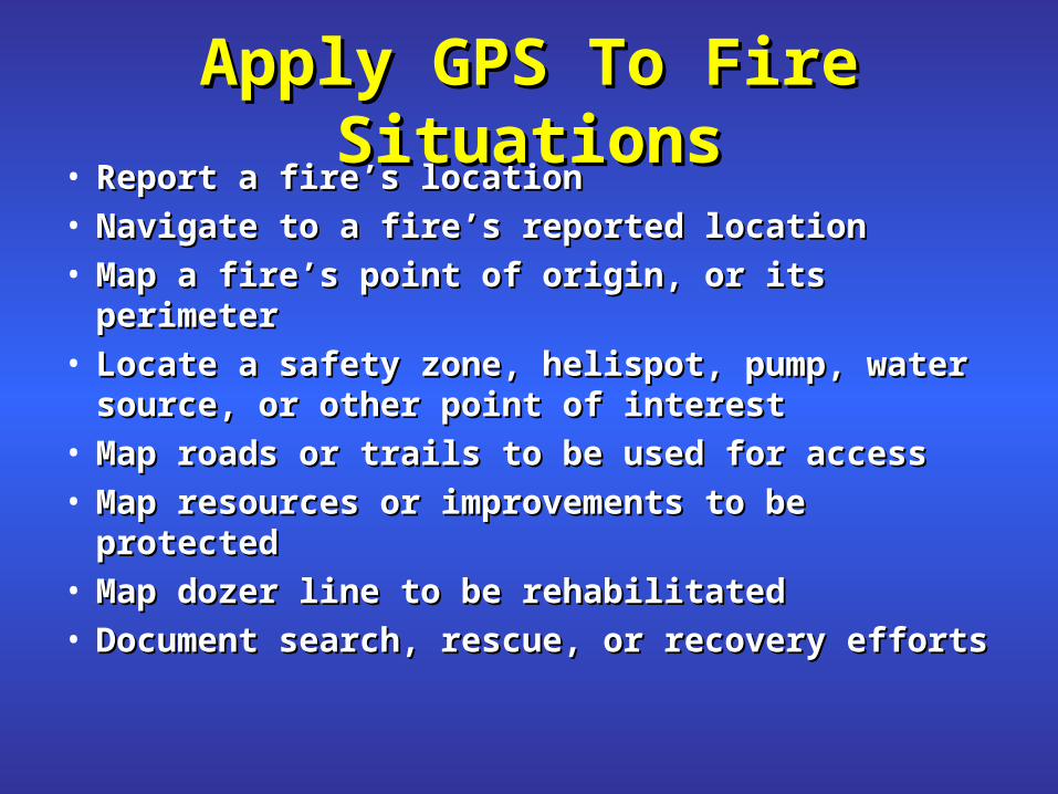
Apply GPS To Fire SituationsApply GPS To Fire Situations• Report a fire’s locationReport a fire’s location• Navigate to a fire’s reported locationNavigate to a fire’s reported location• Map a fire’s point of origin, or its perimeterMap a fire’s point of origin, or its perimeter• Locate a safety zone, helispot, pump, water Locate a safety zone, helispot, pump, water
source, or other point of interestsource, or other point of interest• Map roads or trails to be used for accessMap roads or trails to be used for access• Map resources or improvements to be protectedMap resources or improvements to be protected• Map dozer line to be rehabilitatedMap dozer line to be rehabilitated• Document search, rescue, or recovery effortsDocument search, rescue, or recovery efforts
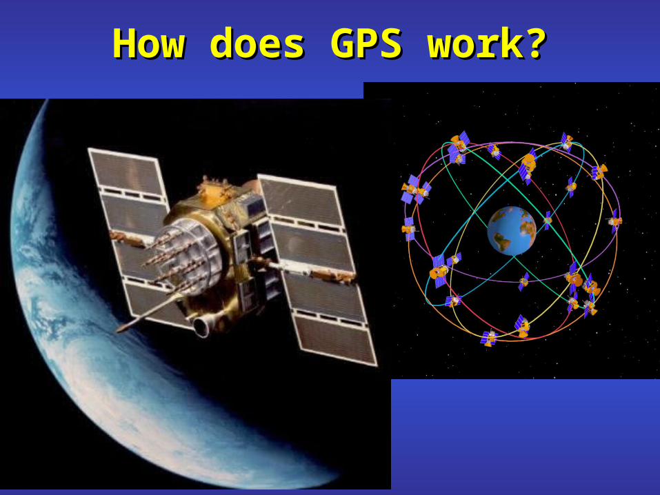
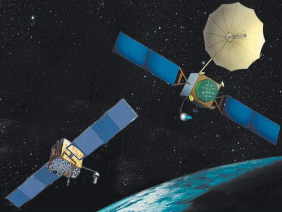
How does GPS work?How does GPS work?

The Global Positioning System The Global Positioning System
Control Segment
Space Segment User
Segment
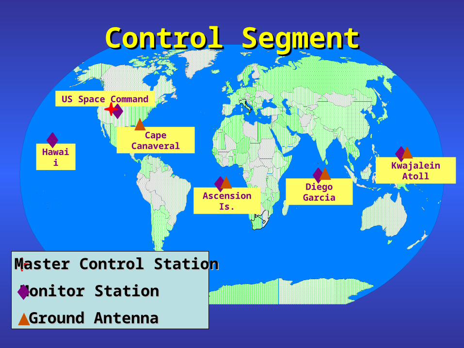
Kwajalein Atoll
US Space Command
Control SegmentControl SegmentControl SegmentControl Segment
Hawaii
Ascension Is.
Diego Garcia
Cape Canaveral
Ground AntennaGround Antenna
Master Control StationMaster Control Station
Monitor StationMonitor Station
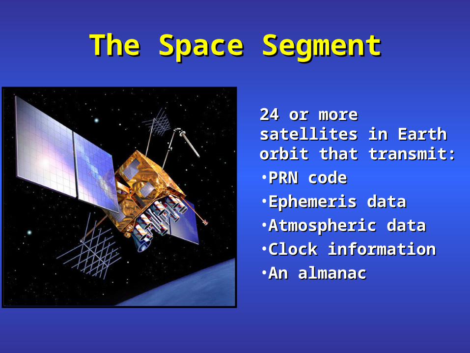
The Space SegmentThe Space Segment
24 or more satellites in 24 or more satellites in Earth orbit that Earth orbit that transmit:transmit:•PRN codePRN code•Ephemeris dataEphemeris data•Atmospheric dataAtmospheric data•Clock informationClock information•An almanacAn almanac
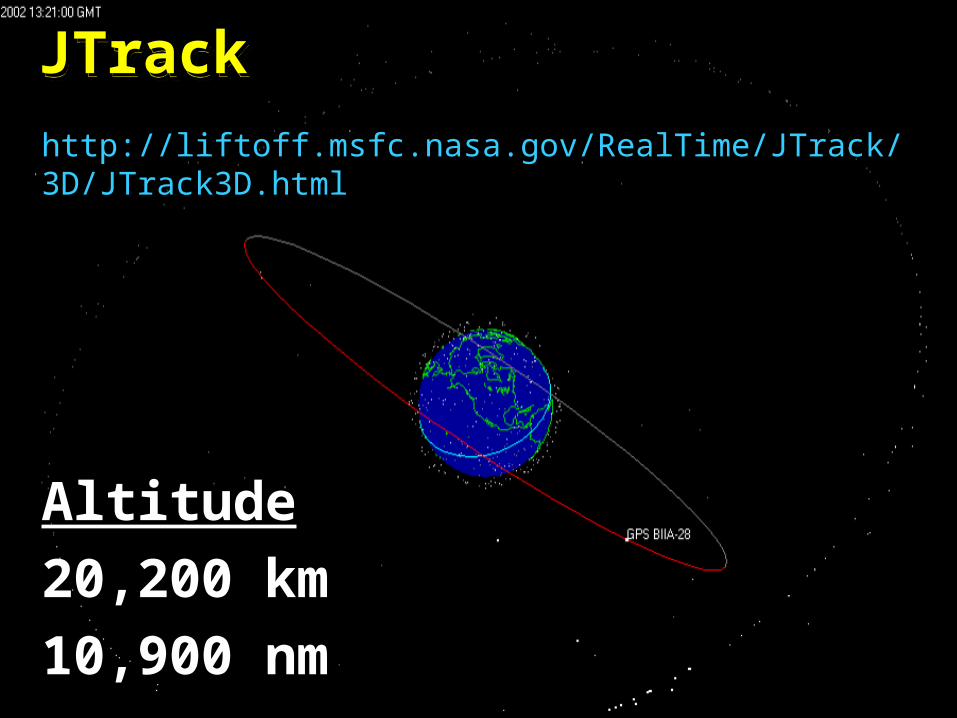
JTrackJTrackJTrackJTrack
http://liftoff.msfc.nasa.gov/RealTime/JTrack/3D/JTrack3D.html
AltitudeAltitude
20,200 km 20,200 km
10,900 nm10,900 nm
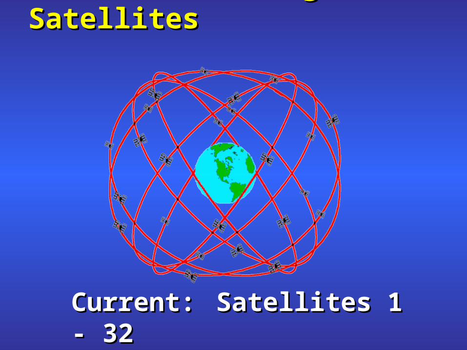
Earth in a Cage of Satellites Earth in a Cage of Satellites
Current:Current: Satellites 1 - 32Satellites 1 - 32Max:Max: 32 Satellites32 Satellites

MilitaryMilitary Search and rescueSearch and rescue Disaster reliefDisaster relief SurveyingSurveying Marine, aeronautical and terrestrial navigationMarine, aeronautical and terrestrial navigation Remote controlled vehicle and robot guidanceRemote controlled vehicle and robot guidance Satellite positioning and trackingSatellite positioning and tracking ShippingShipping Geographic Information Systems (GIS)Geographic Information Systems (GIS) RecreationRecreation
User SegmentUser Segment

How to Calculate a PositionHow to Calculate a Position
Measure the Distance to the Satellites
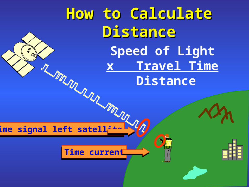
How to Calculate DistanceHow to Calculate Distance
Speed of Light x Travel Time
Distance
Time signal left satelliteTime signal left satellite
Time currentTime current

Minimum # of Satellites RequiredMinimum # of Satellites Required-Algebra Problem-Algebra Problem
Unknown time
latitudelongitudeelevation
4 4 Unknowns We Need 4 Satellites
Equation satellite location
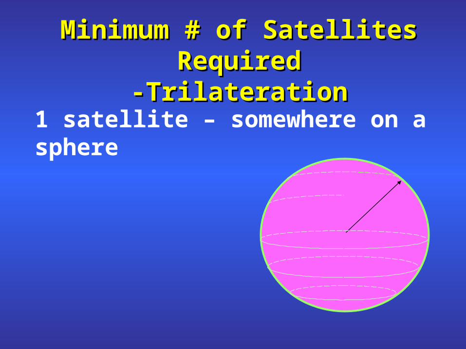
Minimum # of Satellites RequiredMinimum # of Satellites Required-Trilateration-Trilateration
1 satellite – somewhere on a sphere
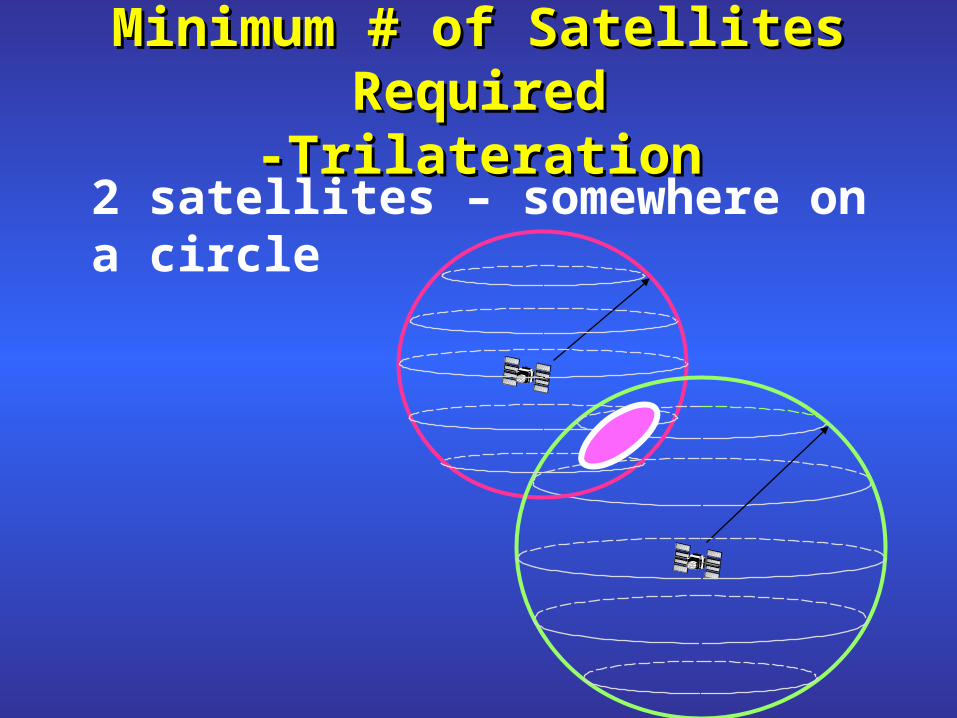
Minimum # of Satellites RequiredMinimum # of Satellites Required-Trilateration-Trilateration
2 satellites – somewhere on a circle

Minimum # of Satellites RequiredMinimum # of Satellites Required-Trilateration-Trilateration
3 satellites – one of two points
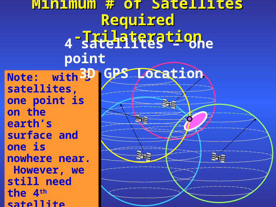
Minimum # of Satellites RequiredMinimum # of Satellites Required-Trilateration-Trilateration
Note: with 3 satellites, one point is on the earth’s surface and one is nowhere near. However, we still need the 4th satellite because receiver clocks are inaccurate.
Note: with 3 satellites, one point is on the earth’s surface and one is nowhere near. However, we still need the 4th satellite because receiver clocks are inaccurate.
4 satellites – one point3D GPS Location
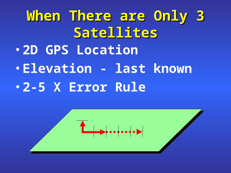
When There are Only 3 SatellitesWhen There are Only 3 Satellites
• 2D GPS Location
• Elevation - last known
• 2-5 X Error Rule

- Want tetrahedron as large as possible- Want index as low as possible
Garmin Estimated AccuracyGarmin Estimated AccuracyRelies on Dilution of Precision
DOPsTDOPVDOPHDOPPDOPGDOP
DOPsTDOPVDOPHDOPPDOPGDOP

Ideal Satellite GeometryIdeal Satellite GeometryIdeal Satellite GeometryIdeal Satellite GeometryN
S
W E

Good Satellite GeometryGood Satellite GeometryGood Satellite GeometryGood Satellite Geometry

Poor Satellite GeometryPoor Satellite GeometryPoor Satellite GeometryPoor Satellite GeometryN
S
W E

Poor Satellite GeometryPoor Satellite GeometryPoor Satellite GeometryPoor Satellite Geometry
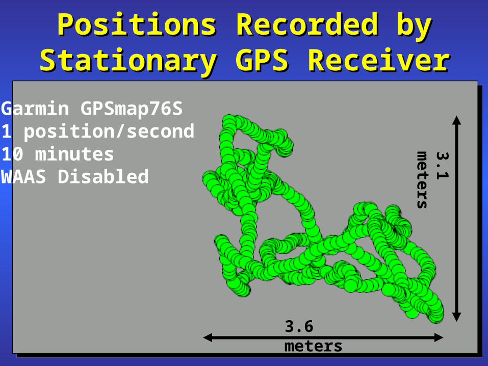
Positions Recorded by Positions Recorded by Stationary GPS ReceiverStationary GPS Receiver
Garmin GPSmap76S 1 position/second10 minutesWAAS Disabled
3.6 meters
3.1 meters

ErrorsErrors(tens of meters)(tens of meters)
IonosphereTroposphereSatellite Clock Errors Satellite Ephemeris ErrorsMultipath Receiver Noise
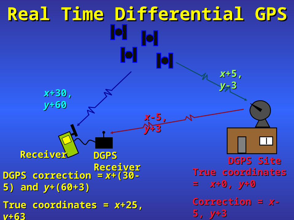
DGPS SiteDGPS Site
xx+30, +30, yy+60+60
xx+5, +5, yy-3-3
True coordinates = True coordinates = xx+0, +0, yy+0 +0
Correction = Correction = xx-5, -5, yy+3+3
DGPS correction =DGPS correction = x x+(30-5) and +(30-5) and yy+(60+3)+(60+3)
True coordinates = True coordinates = xx+25, +25, yy+63+63
xx-5, -5, yy+3+3
Real Time Differential GPSReal Time Differential GPSReal Time Differential GPSReal Time Differential GPS
DGPS ReceiverDGPS ReceiverReceiverReceiver
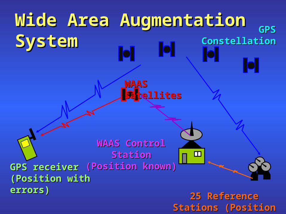
WAAS satellitesWAAS satellites
GPS GPS ConstellationConstellation
WAAS Control WAAS Control StationStation
(Position known)(Position known)GPS receiverGPS receiver(Position with (Position with errors)errors)
Wide Area Augmentation Wide Area Augmentation SystemSystem
25 Reference Stations 25 Reference Stations (Position known)(Position known)

WAASWAASWide Area Augmentation System
WAAS Satellite
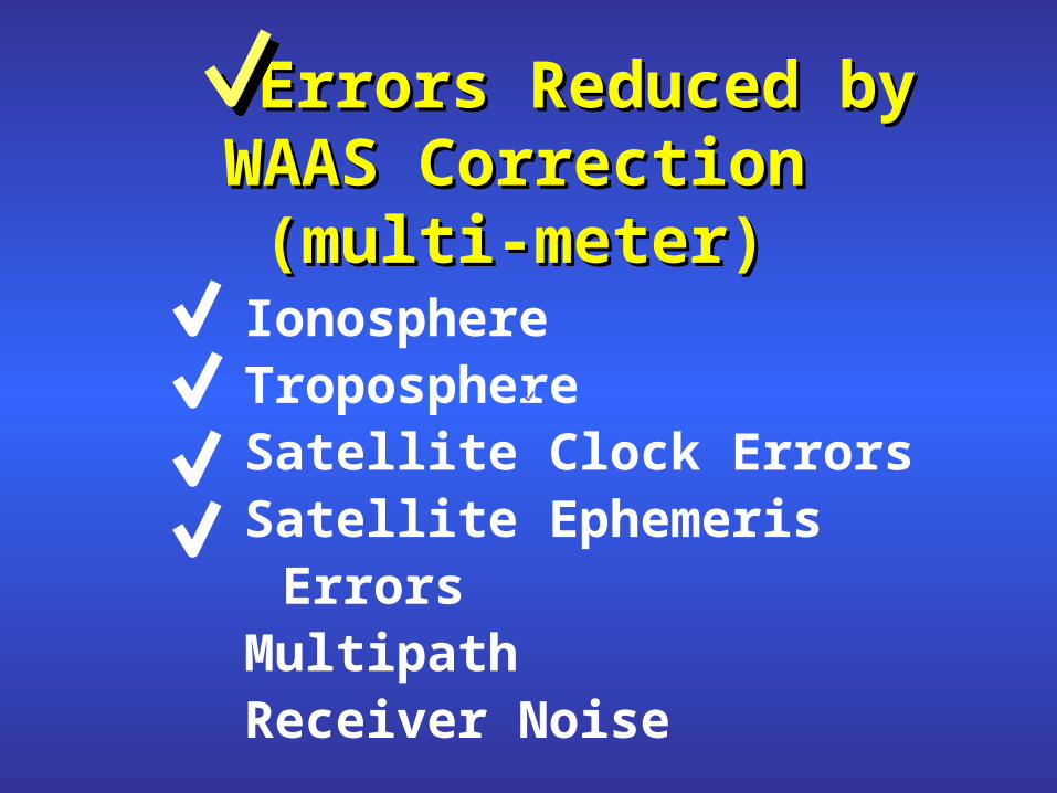
Errors Reduced by Errors Reduced by WAAS CorrectionWAAS Correction
(multi-meter)(multi-meter)IonosphereTroposphereSatellite Clock Errors Satellite Ephemeris ErrorsMultipath Receiver Noise

Receiving WAAS CorrectionReceiving WAAS Correction
If WAAS signal intermittent- WAAS correction for SV 19
No WAAS correction for SV 11
WAAS correction for SV 19No WAAS correction for SV 11
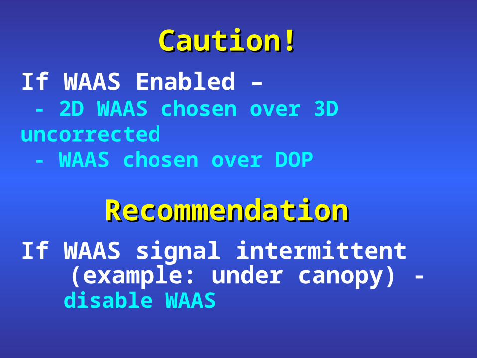
Caution!Caution!If WAAS Enabled –
- 2D WAAS chosen over 3D uncorrected- WAAS chosen over DOP
RecommendationRecommendationIf WAAS signal intermittent
(example: under canopy) - disable WAAS
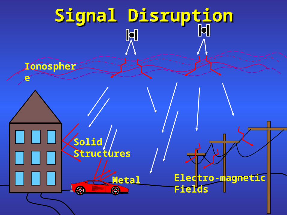
Signal DisruptionSignal DisruptionSignal DisruptionSignal Disruption
Ionosphere
Solid Structures
Metal Electro-magnetic Fields

Good Data Collection TechniquesGood Data Collection Techniques
External AntennaMap76S more accurate under canopy
Sleeve Mounts
Vehicle Brackets
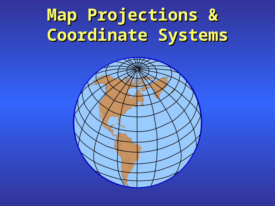
Map Projections & Map Projections & Coordinate SystemsCoordinate SystemsMap Projections & Map Projections &
Coordinate SystemsCoordinate Systems
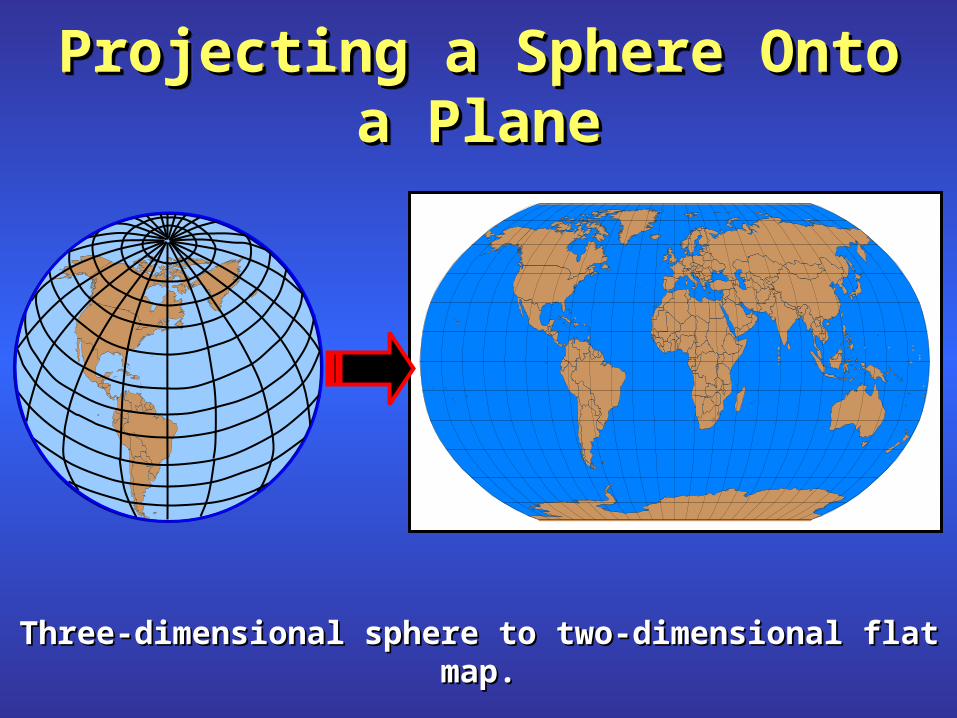
Projecting a Sphere Onto a Projecting a Sphere Onto a PlanePlane
Projecting a Sphere Onto a Projecting a Sphere Onto a PlanePlane
Three-dimensional sphere to two-dimensional flat map.Three-dimensional sphere to two-dimensional flat map.

Examples of Several Examples of Several ProjectionsProjections
Examples of Several Examples of Several ProjectionsProjections
Depending on the projection, a certain amount of distortion occurs when portraying the earth on paper.
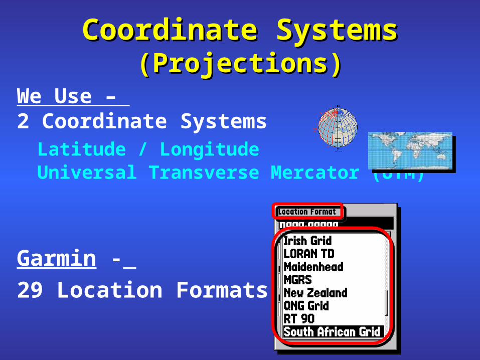
Coordinate Systems Coordinate Systems (Projections)(Projections)
We Use – 2 Coordinate Systems
Latitude / LongitudeUniversal Transverse Mercator (UTM)
Garmin -
29 Location Formats

0º0º
0º0º
PointPoint ofof OriginOrigin
PrimePrime MeridianMeridian
EquatorEquator
(Longitude)(Longitude)
(Latitude)(Latitude)
10º N10º N
30º N30º N
10º S
Latitude & LongitudeLatitude & LongitudeLatitude & LongitudeLatitude & Longitude
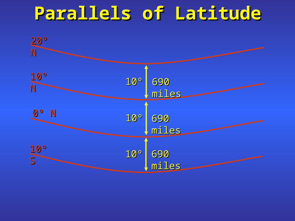
ParallelsParallels ofof LatitudeLatitudeParallelsParallels ofof LatitudeLatitude
10º10º
10º10º
10º10º
690690 milesmiles
690690 milesmiles
690 miles690 miles
10º S10º S
0º N0º N
10º N10º N
20º N20º N

Meridians of LongitudeMeridians of LongitudeMeridians of LongitudeMeridians of Longitude
10º10º
10º10º
110º W110º W120º W120º W
690 miles690 miles
460 miles460 miles
240 mi240 mi10º10º
Equator
To North Pole
To South Pole

Three Ways To Express Three Ways To Express Latitude / LongitudeLatitude / Longitude
on a Garminon a Garmin

Three Ways To Express Three Ways To Express Latitude / LongitudeLatitude / Longitude
(for (for the Samethe Same Location) Location)
hddd° mm’ ss.s”Degrees-Minutes-Seconds (Decimal Seconds)N 43° 40’ 55.8”, W 116° 17’ 14.1”
hddd° mm.mmm’Degrees-Minutes (Decimal Minutes)N 43° 40.930’, W 116° 17.235’
hddd.ddddd°Degrees (Decimal Degrees)N 43.68216°, W 116.28725°
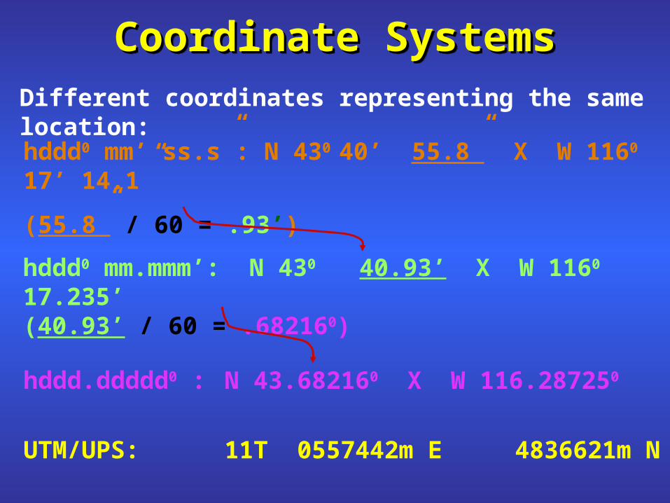
Coordinate SystemsCoordinate SystemsCoordinate SystemsCoordinate Systems
hddd0 mm’ ss.s”: N 430 40’ 55.8” X W 1160 17’ 14.1”
(55.8” / 60 = .93’)
Different coordinates representing the same location:
hddd0 mm.mmm’: N 430 40.93’ X W 1160 17.235’(40.93’ / 60 = .682160)
hddd.ddddd0 : N 43.682160 X W 116.287250
UTM/UPS: 11T 0557442m E 4836621m N

Example: Error in LatitudeExample: Error in Latitude
35° 24´ 45˝ N
35° 24.450’ N
1/3 of a mile

Lat / Long ShortcomingsLat / Long Shortcomings
1 minute??
??
1 d
eg
ree
1 1 degree
+
+
+
??

Universal Transverse MercatorUniversal Transverse Mercator
• measured in meters• located in zones (1 - 60)• include northing and easting• are positive
Coordinates
Zone Easting
Northing
Latitude Band
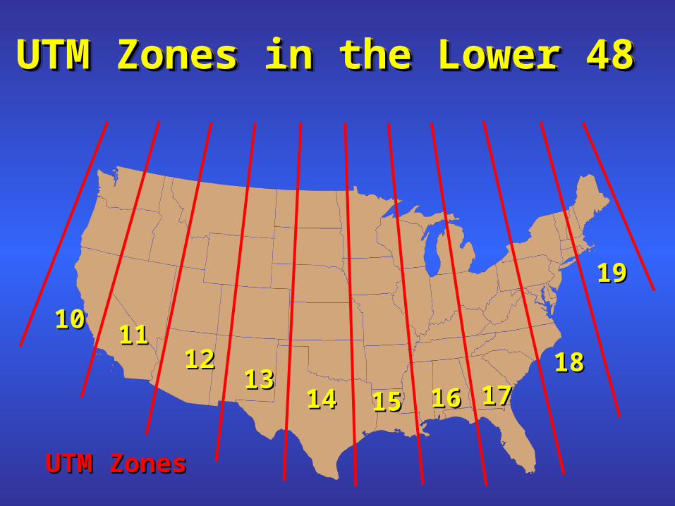
UTM Zones in the Lower 48 UTM Zones in the Lower 48 UTM Zones in the Lower 48 UTM Zones in the Lower 48
10101111
12121313
1414 1515 1616 17171818
1919
UTM ZonesUTM Zones
1 60
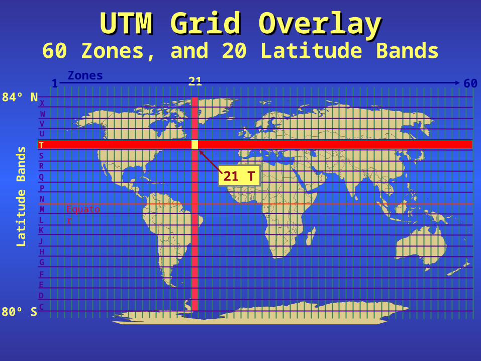
UTM Grid OverlayUTM Grid OverlayUTM Grid OverlayUTM Grid Overlay60 Zones, and 20 Latitude Bands
21
G
M
WX
80º S
84º N
D
C
EF
HJ
KL
NP
QRST
UV
Lat
itu
de
Ban
ds
21 T
T
Zones
Equator
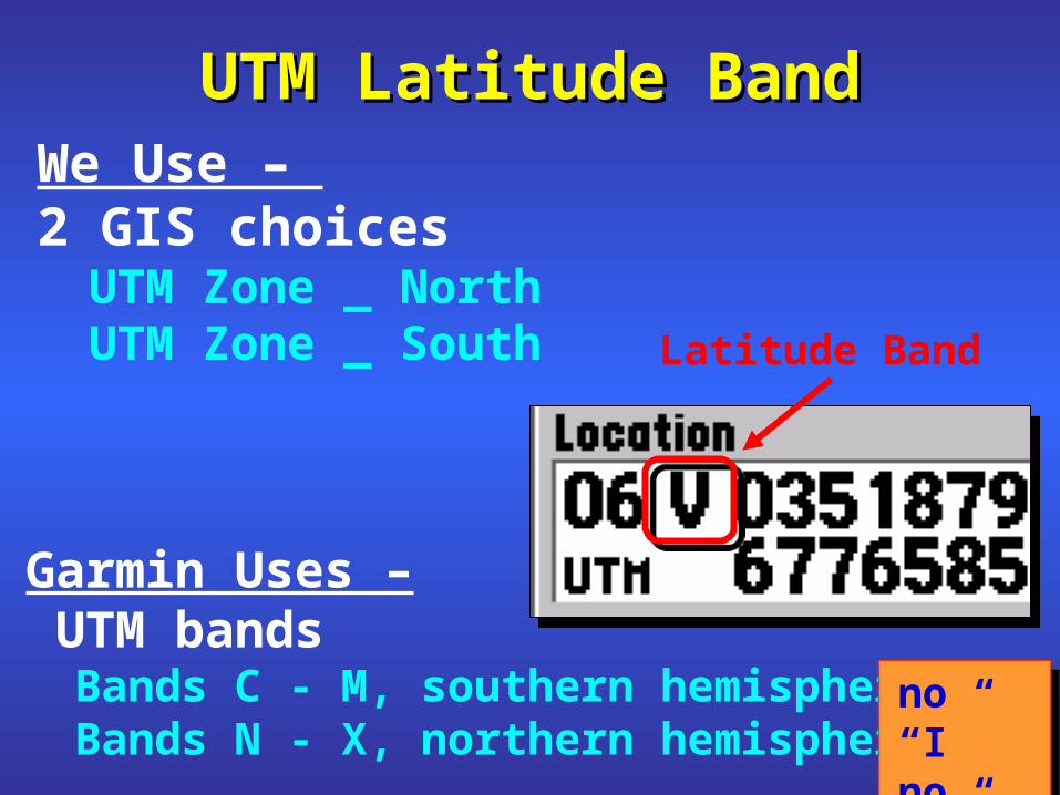
Garmin Uses – UTM bands
Bands C - M, southern hemisphereBands N - X, northern hemisphere
UTM Latitude BandUTM Latitude Band
Latitude Band
We Use – 2 GIS choices
UTM Zone _ NorthUTM Zone _ South
no “I”no “O”
no “I”no “O”
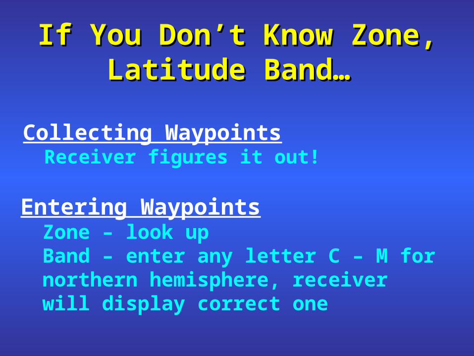
If You Don’t Know Zone, If You Don’t Know Zone, Latitude Band… Latitude Band…
Entering WaypointsZone – look upBand – enter any letter C – M for
northern hemisphere, receiver will display correct one
Collecting WaypointsReceiver figures it out!

UTM Location FormatUTM Location Format on a Garmin on a Garmin
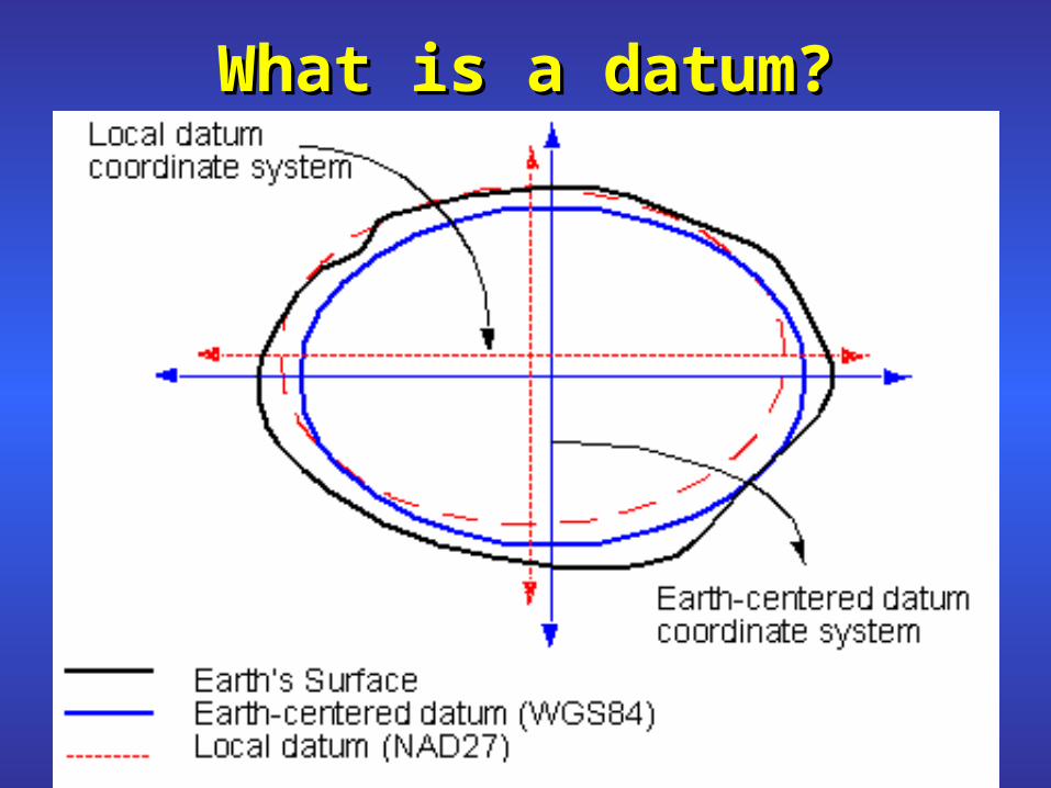
What is a datum?What is a datum?

DatumsDatums
WGS 84 NAD 83 NAD 27
Garmin -
>100 Map Datums
We Use –
3 Datums
1 meter1 meter 10 - 120 meters10 - 120 meters
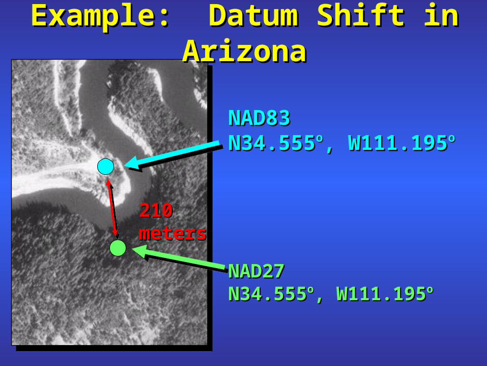
Example: Datum Shift in ArizonaExample: Datum Shift in Arizona
NAD83NAD83N34.555N34.555oo, W111.195, W111.195oo
NAD27NAD27N34.555N34.555oo, W111.195, W111.195oo
210 meters210 meters
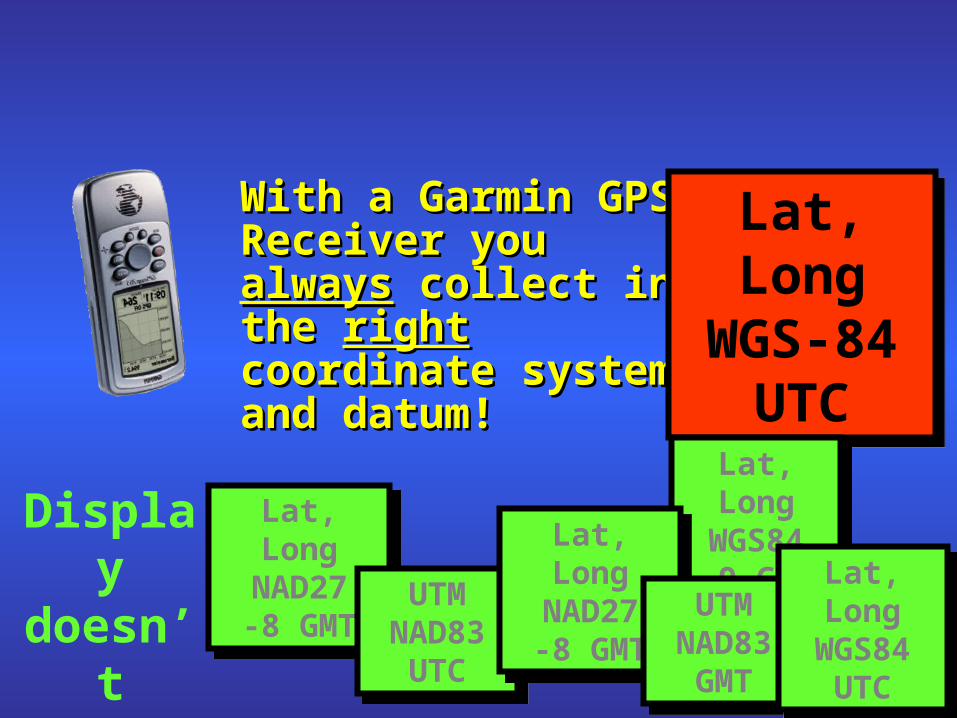
With a Garmin GPS With a Garmin GPS Receiver you Receiver you alwaysalways collect in the collect in the right right coordinate system coordinate system and datum!and datum!
Lat, LongWGS-84
UTC
Lat, LongWGS-84
UTC
Lat, LongNAD27-8 GMT
Lat, LongNAD27-8 GMT UTM
NAD83UTC
UTMNAD83
UTC
Lat, LongWGS84-9 GMT
Lat, LongWGS84-9 GMTLat, Long
NAD27-8 GMT
Lat, LongNAD27-8 GMT UTM
NAD83GMT
UTMNAD83GMT
Lat, LongWGS84
UTC
Lat, LongWGS84
UTC
Display doesn’t matter
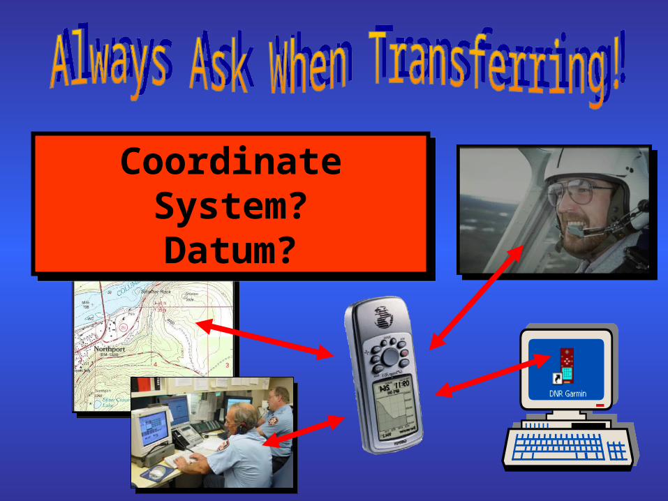
Coordinate System?Datum?
Coordinate System?Datum?

Review of TopicsReview of Topics
- GPS- GPS
- WAAS- WAAS
- Coordinate Systems- Coordinate Systems
- Datums- Datums