intro to how drones are shaping the future of construction sites
TRANSCRIPT

1|
HOW DRONES ARE SHAPING THE FUTURE OF CONSTRUCTION SITES
March 31, 2016
2|
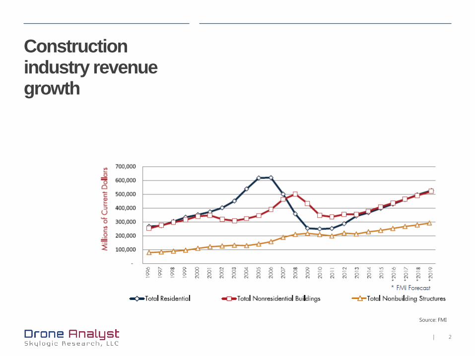
Construction industry revenue growth
Source: FMI

3|
FAA Section 333 intended operations by industryDrones in construction: Current
Source: Baird
4|
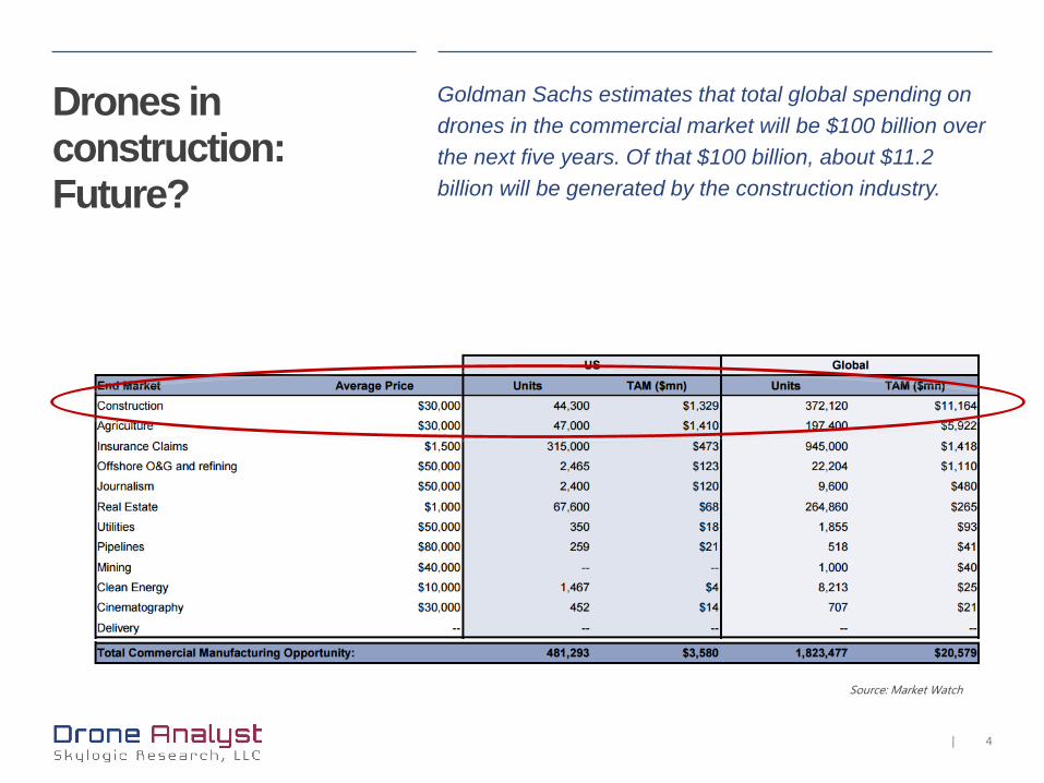
Drones in construction:Future?
Goldman Sachs estimates that total global spending on drones in the commercial market will be $100 billion over the next five years. Of that $100 billion, about $11.2 billion will be generated by the construction industry.
Source: Market Watch

5|
Lexicon Orthomosaic
Photogrammetry
Digital elevation model
LiDAR
Point cloud
Building Information Modeling (BIM)
Thermal imaging
6|
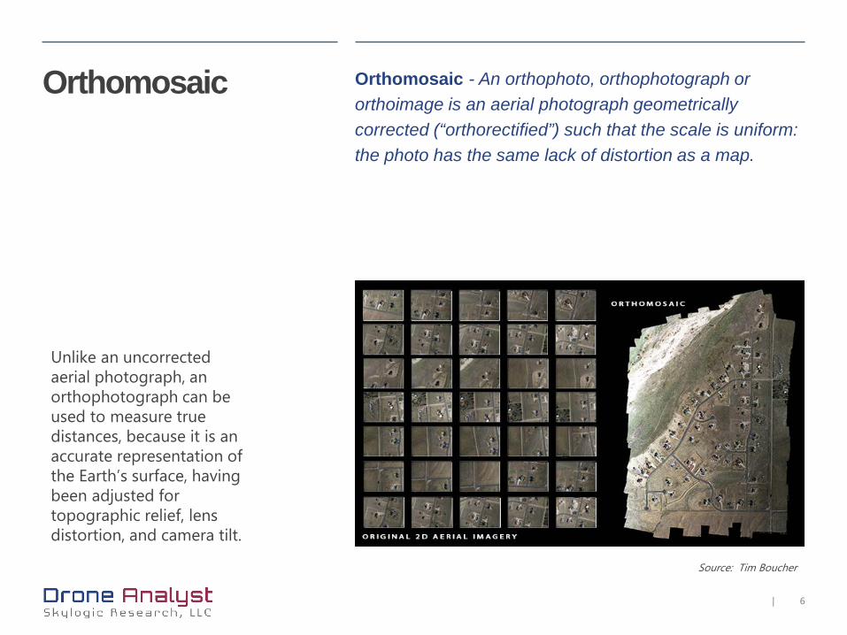
Orthomosaic
Unlike an uncorrected aerial photograph, an orthophotograph can be used to measure true distances, because it is an accurate representation of the Earth’s surface, having been adjusted for topographic relief, lens distortion, and camera tilt.
Orthomosaic - An orthophoto, orthophotograph or orthoimage is an aerial photograph geometrically corrected (“orthorectified”) such that the scale is uniform: the photo has the same lack of distortion as a map.
Source: Tim Boucher

7|
Source: Tim Boucher
Photogrammetry Photogrammetry is a technique which uses photography to extract measurements of the environment. This is achieved through the use of overlapping imagery; where the same feature can be seen from two perspectives it is possible to calculate m

8|
DEM Digital elevation model (DEM) is a digital model or 3D representation of a terrain's surface created from terrain elevation data.
DSM: Digital Surface Model = (earth) surface including objects on itDTM: Digital Terrain Model = (earth) surface without any objects
Source: Wikipedia
9|
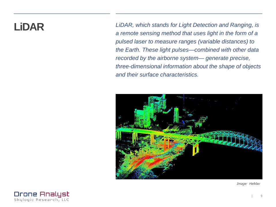
Image: HeMav
LiDAR LiDAR, which stands for Light Detection and Ranging, is a remote sensing method that uses light in the form of a pulsed laser to measure ranges (variable distances) to the Earth. These light pulses—combined with other data recorded by the airborne system— generate precise, three-dimensional information about the shape of objects and their surface characteristics.
10|
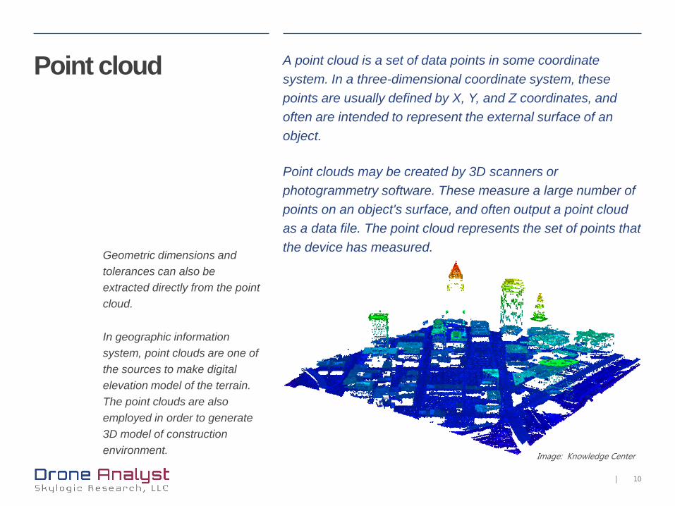
Image: Knowledge Center
Point cloud A point cloud is a set of data points in some coordinate system. In a three-dimensional coordinate system, these points are usually defined by X, Y, and Z coordinates, and often are intended to represent the external surface of an object.
Point clouds may be created by 3D scanners or photogrammetry software. These measure a large number of points on an object's surface, and often output a point cloud as a data file. The point cloud represents the set of points that the device has measured.Geometric dimensions and
tolerances can also be extracted directly from the point cloud.
In geographic information system, point clouds are one of the sources to make digital elevation model of the terrain.The point clouds are also employed in order to generate 3D model of construction environment.

11|
BIM Building information modeling (BIM) is a process involving the generation and management of digital representations of physical and functional characteristics of places. Files are created which can be exchanged or networked to support decision-making about a place.
Current BIM software is used by individuals, businesses and government agencies who plan, design, construct, operate and maintain diverse physical infrastructures, such as water, wastewater, electricity, gas, refuse and communication utilities, roads, bridges and ports, houses, apartments, schools and shops, offices, factories, warehouses and prisons.
Credit: Asia Green Buildings
12|
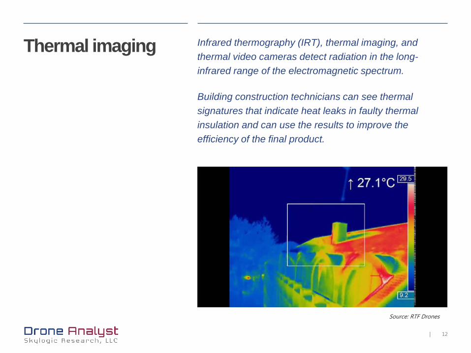
Source: RTF Drones
Thermal imaging Infrared thermography (IRT), thermal imaging, and thermal video cameras detect radiation in the long-infrared range of the electromagnetic spectrum.
Building construction technicians can see thermal signatures that indicate heat leaks in faulty thermal insulation and can use the results to improve the efficiency of the final product.
13|
About Skylogic Research, LLC is a research, content, and advisory firm supporting all participants in the commercial unmanned aircraft systems (UAS) industry.
We provide research-based insights needed to make critical investment decisions with confidence.
Our focus is on the needs of three constituents:
• Buyers of UAS technology and services – to help inform their acquisition decisions
• Suppliers and service providers – who need research and insight into buyer needs
• Investors – who need to distinguish technical and market viability
This focus, plus research as a foundation and reach into a community of more than 90,000 business executives and innovators through social media and media partnerships, allows Skylogic Research to deliver a high-value, low-risk method for achieving optimal understanding.
Learn more:
Web http://droneanalyst.com
Twitter @droneanalyst
Email [email protected]

14|
© 2016 Skylogic Research, LLC.All rights reserved.
No part of this publication may be reproduced or transmitted in any form or for any purpose without the express permission of Skylogic Research.
Drone Analyst products and services mentioned herein as well as their respective logos are trademarks of Skylogic Research.
These materials are provided by Done Analyst for informational purposes only, without representation or warranty of any kind, and Skylogic Research shall not be liable for errors or omissions with respect to the materials.
In particular, Skylogic Research has no obligation to pursue any course of business outlined in this document or any related presentation, or to develop or release any functionality mentioned therein. This document, or any related presentation, and Skylogic Research strategy and possible future developments, products, and/or research directions are all subject to change and may be changed by Skylogic Researchat any time for any reason without notice. The information in this document is not a commitment, promise, or legal obligation to deliver any material, research notes, or web content.