internet-based satellite navigation receivers using egnos: the
TRANSCRIPT

Internet-Based Satellite Navigation Receivers using EGNOS: the ESA SISNET Project
Félix Torán-Martí(1), Javier Ventura-Traveset(1), Juan Carlos de Mateo(2)
(1) European Space Agency (ESA)
GNSS-1 Project Office. Centre Spatial de Toulouse. 18, Av. Edouard Belin. 31401. Toulouse CEDEX 4 (France)
[email protected] ; [email protected]
(2) European Space Agency (ESA) Payload System Division, ESTEC, Noordwijk (The Netherlands)
INTRODUCTION
EGNOS, the European Geostationary Navigation Overlay Service, is the first step on the European contribution to the Global Navigation Satellite System, and a fundamental stepping-stone towards GALILEO, Europe’s own Global Navigation Satellite System. EGNOS is an augmentation system to the GPS and GLONASS Satellite Navigation systems, which provides and guarantees navigation signals for aeronautical, maritime and land mobile Trans-European network applications. Since January 2000, a pre-operational signal of EGNOS is available through the so-called EGNOS System Test Bed (ESTB). The ESTB is a representative real time mock up of the final EGNOS system. EGNOS will broadcast their wide area / integrity message through Geostationary satellites. The ESTB (EGNOS prototype) is already broadcasting the EGNOS message through the Inmarsat III AOR-E satellite (broadcast through Inmarsat III IOR satellite is also planned in 2002). Satellite broadcasting through GEOs is proved to be an efficient strategy for avionic applications and other modes of transport. For some applications, though, GEO broadcasting may provide some limitations (e.g. building obstacles in cities or rural canyons may difficult the GEO reception). While the EGNOS message will still be very useful for those applications, a different transmission link may need to be considered to take the maximum advantage of the EGNOS potential. For this reason, ESA has recently launched specific contract activities (through the Advanced System Telecommunication Equipment programme –ASTE–) to assess and demonstrate architectures where the ESTB signal is broadcast through non-GEO means (e.g. FM or GSM broadcasting) [1]. In this context, ESA has also launched an internal project to provide access to the EGNOS test bed messages through the Internet. The product of this project is a new technology, called SISNET (Signal in Space through the Internet), which is the main purpose of this paper and it is described here in some detail. A first prototype of the SISNET concept has been set-up by the ESA GNSS-1 Project Office. This first prototype uses a PC computer to implement the user equipment software, and the connection to the Internet is achieved using a LAN environment (via a proxy server). A generic GPS receiver is connected to the computer through a serial port. The user software implements several SISNET-based applications, which are described in this paper. The SISNET project can grant important advantages to the GPS land-user community. A user equipped with a GPS receiver and a GSM (or GPRS) modem can access the SISNET services, thus being able to benefit from the EGNOS augmentation signals, even under situations of GEO blocking. It is firmly believed by the authors that the combination of the EGNOS power and the Internet power will open a large amount of applications for satellite Navigation; some of those will also be introduced through this paper.
EGNOS AND EGNOS TESTBED BACKGROUND
The European Tripartite Group (ETG)1, (ESA – European Commission – EUROCONTROL) is implementing, via the EGNOS project, the European contribution to the Global Navigation Satellite System (GNSS-1), which will provide and guarantee navigation signals for aeronautical, maritime and land mobile Trans-European network applications. On behalf of this tripartite group, the European Space Agency is responsible for the system design, development and qualification of an Advanced Operational Capability (AOC) of the EGNOS system. EGNOS will significantly improve the accuracy of GPS, typically from 20 to 3-5 metres vertical accuracy, and to 1-2 metres horizontal accuracy. Moreover, EGNOS will offer a service guarantee by means of the Integrity signal and it will also provide additional ranging signals. For a complete summary of the EGNOS project and its status, the reader is referred to [2]. Since January 2000, a pre-operational signal of EGNOS is available through the so-called EGNOS System Test Bed (ESTB). The ESTB is a representative real time mock up of the final EGNOS system. The ESTB architecture is presented in Fig 1. It consist of a space segment comprising nominally two transponders on board the Inmarsat-III Atlantic Ocean East and the Indian Ocean satellites, a ground segment comprising a number of reference stations spread over Europe and beyond, a processing centre and the Inmarsat uplink stations. Communication lines interconnect all stations [3]. The main objectives of the ESTB are the following: - To have an assessment of the global performance achievable with EGNOS; - To analyse in depth specific critical design issues or tradeoffs between several options; - To develop and validate system test methods; - To provide a representative tool for Civil Aviation; - To demonstrate to the final users the system operation and to promote new satellite navigation applications. Concerning the last objective (the promotion of satellite navigation applications), the ESTB has already been successfully used in specific aviation, maritime and land mobile application tests [4,5]. In addition, ESA has recently launched specific contract activities (through the Advance Telecommunications and Navigation Technology Programme –ASTE–) to assess and demonstrate architectures where the ESTB signal is broadcast through non-GEO means (e.g. FM or GSM broadcasting) [1]. In this context, ESA has also launched an internal ESA project to provide access to the EGNOS test bed messages through the Internet. This Project, called SISNET (Signal in Space through the Internet), is the main purpose of this paper and it is described in some detail in next Sections.
Fig. 1. The EGNOS System Test Bed architecture
1 A formal agreement based on article 228 of the EC treaty was concluded on 18.06.96 between the European Community, EUROCONTROL and ESA, for the development of the European Contribution to the first generation Global Navigation Satellite System (GNSS-1).

THE SISNET TECHNOLOGY
EGNOS will broadcast their wide area / integrity message through Geostationary satellites. The ESTB (EGNOS prototype) is already broadcasting the EGNOS message through the Inmarsat III AOR-E satellite, located at 15.5 degrees West. During year 2002, the ESTB will also broadcast through the Inmarsat III IOR satellite, located at 64.5 degrees East. The GEO broadcast of the EGNOS messages is well regulated by the Standard and Recommended Practises (SARPS) produced by the International Civil Aviation Organisation (ICAO). Satellite broadcasting through GEOs is proved to be an efficient strategy for avionic applications and other modes of transport. For some applications, though, GEO broadcasting may provide some limitations (e.g. building obstacles in cities or rural canyons may difficult the GEO reception, etc). While the EGNOS message will still be very useful for those applications, a different transmission link may need to be considered to maximally exploit all EGNOS potential. In addition, the availability of the EGNOS signal through the Internet may also be of interest for people aiming at monitoring the EGNOS signal for statistics, off-line analysis or system performance assessment (through the connection of the EGNOS signal to real-time simulators [6-8]). For those all potential users, ESA has launched the SISNET project. From a general point of view, SISNET is a new technology, oriented to the development of applications combining any field of Science / Engineering, Satellite Navigation and the Internet. The main objective of SISNET is to provide access to the EGNOS messages, using a GSM / GPRS wireless link (or any other kind of connection) to access the Internet. Some of the challenges of the SISNET system include: - The SISNET project should not interfere at all the EGNOS/ESTB architecture. - Connections to SISNET server need to be reliable and stable. - The full additional delay due to the SISNET introduction needs to be minimised and controlled. - Any generic GPS receiver should be easily upgradeable to benefit from the SISNET service. - GPS receivers using SISNET should include specific functions to deal with potential delays or service interruptions. - A GPS receiver working in SISNET mode should have enhanced performance versus a GPS-only receiver. - A SISNET-enabled GPS receiver should be able to revert to GPS-only mode in case of Internet connection problems. - The number of simultaneous users of SISNET should be controllable so that the system efficiency may be guaranteed. - Others. Assuming those challenges, a first prototype of the SISNET platform has been set-up by the ESA GNSS-1 Project Office. This first prototype uses a PC computer to implement the user equipment software, and the connection to the Internet is achieved using a LAN environment (via a proxy server). A generic GPS receiver is connected to the computer through a serial port. The software implements the basic DSP for positioning improvement, and a Graphical User Interface, in order to demonstrate the accuracy improvement obtained with the use of SISNET, with respect to the GPS-only solution. A more detailed explanation of the SISNET architecture is described in next Sections. IS SISNET USEFUL?
ESA has performed a preliminary study, in order to answer this question. The study is based on the use of the ESA ESPADA [6-8] simulator. The output of the study is a Technical Note [9], which is available under request. Assumptions used for this analysis may be considered conservative: they are based on specified URE of 6 meters for the GPS satellites [10], and also on specified residual corrections statistical errors for EGNOS [13]. A major outcome of this study is illustrated in the bar plot of Fig. 2, which corresponds to a mask angle of 25 degrees (low visibility conditions). Each bar indicates the availability (vertical axis) corresponding to an accuracy requirement (horizontal axis). The blue bars refer to a GPS-only scenario, while the red bars correspond to a GPS+EGNOS configuration. The reading of that plot is the following: Under low visibility conditions (mask angle of 25 degrees):
- GPS offers low availability. Even in the case of 50 meters of accuracy, GPS is available less than 75% of time, while EGNOS is available 95% of the time;

- EGNOS is much more resistant to masking angle limitations, providing a high availability (90% to 100%) from 10 meters of accuracy.
Taking those readings into account, a main conclusion can be formulated: EGNOS provides better availability of accuracy than GPS, for any masking angle. Interestingly, in situations in which user visibility of GPS satellites is limited (say to 4 - 5 satellites), the availability of the SBAS corrections plays a major role. Indeed, SBAS-available accuracy is quite insensitive to the number of GPS satellites in visibility, while GPS-only accuracy degrades significantly. SISNET benefits from this, making SBAS messages available regardless of the user visibility conditions.
Fig. 2. GPS/EGNOS comparative for a mask angle of 25 degrees
ARCHITECTURE OF THE SISNET PLATFORM
Fig. 3 illustrates the SISNET platform architecture. The four main components of the system (depicted as computers) are the following:

- Base Station (BS). A PC computer connected to an EGNOS receiver through a serial port. Several software components are installed on the computer, allowing acquiring the EGNOS messages and sending it to a remote computer (called Data Server) in real-time. - Data Server (DS). A high performance computer, optimised for running server applications with a large amount of connected users. The DS functionality is implemented through a software application called SISNET Data Server (SDS). This software receives the EGNOS messages from the BS and transfers them to the remote SISNET users in real time. In addition, the SDS implements all the extra services (present and future) provided by the SISNET system to the users. - User Application Software (UAS). A Software application that accomplishes the SISNET interface control specifications [11], being able to obtain the EGNOS messages in real time (1 message/s or 250 bit/s) from the DS. Moreover, the UAS can access and apply the present and future additional SISNET services. Each concrete SISNET-based application is characterised by a specific processing and output interface stages, which provide the desired functionality and user interface to the UAS. The software can be embedded in different kinds of computers and electronic devices (e.g. Personal Data Assistants). - Web Server. The DS can store the received messages in a remote Web Server via the FTP protocol, enabling future development of Web / WAP applications (accessible to the users through a Web browser or mobile device). Presently, the BS and the DS are installed on the ESA Radionavigation Laboratory in the ESTEC centre (Noordwijk, The Netherlands). The first implementation of the UAS is installed in the EGNOS Project Office (Toulouse, France), where the system is being tested and enhanced. The access to SISNET is today (November 2001) limited to the ESA development team during this phase of the project, but ESA intends to make it available to worldwide users by the end of year 2001.
Fig. 3. Architecture of the SISNET platform

THE ESA USER APPLICATION SOFTWARE
The UAS is the most flexible part of SISNET. As stated above, the potential scope of SISNET applications is really extensive, and each particular application is characterised by a concrete implementation of the UAS. The process of developing SISNET-powered software applications is the following: - Developing a SISNET-compliant client module, implementing the DS2DC protocol (see Fig. 3). That component (called DS2DC Client) shall respect all the requirements stated in the SISNET User Interface Document (UID) [11]. That document provides all the necessary knowledge that shall be taken into account when building SISNET-compliant applications. The UID is now available in electronic format, and can be downloaded from the ESTB section of the ESA website. - Developing one or several processing stages. Those stages are implemented by the developer without any restriction, and provide the UAS with the desired functionality. - Developing a user interface, in order to get information from the user and present the results. ESA has developed -- during the first half of year 2001 -- the first implementation of the SISNET UAS. This software is currently being enhanced and prepared for demonstrations. ESA INTERNAL DEVELOPMENTS
This Section introduces several SISNET-powered applications, internally developed by ESA: - Real-time performance monitoring of the ESTB; - Real-time laboratory for the analysis of the ESTB messages; - Real-time monitoring of the ESTB performance and SIS status through the WWW. These applications are integrated into the ESA UAS. In addition, an ongoing application is discussed: EGNOS-augmented positioning through the Internet. Real Time Performance Monitoring
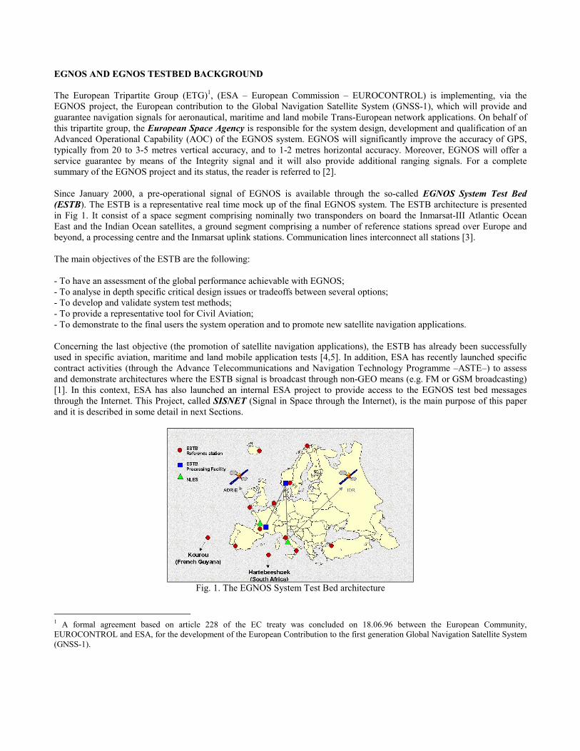
A powerful application of SISNET consists on substituting the UAS processing stage by two new components: - The ESPADA software (the ESA internal EGNOS simulation tool) [6-8] - An interface block, able to adapt the data produced by SISNET to the format used by ESPADA. Fig. 4 depicts the resulting architecture of the system, after making those changes. Since the introduction of version 3.0, ESPADA allows analysing the EGNOS system performances using real data. Those data encapsulate the EGNOS messages and are previously recorded into a file, using an EGNOS receiver and the appropriate logging software. The actual SISNET/ESPADA integration avoids the need of logging sessions, since SISNET provides a live virtual receiver wherever a connection to the Internet is available. Indeed the present version of ESPADA is able to present performance availability maps every ten minutes, totally based on the EGNOS messages provided by SISNET in real time. The only requirement is a connection to the Internet.
Real-Time Laboratory Software for the Analysis of the ESTB messages
Since SISNET broadcasts the ESTB messages in real-time, an immediate application consists on implementing real-time algorithms for the analysis of each message contents. ESA has integrated this kind of algorithms into the SISNET UAS, and linked it to several graphical monitoring panels (Fig. 5). Consequently, UAS users can quickly and visually navigate the information transmitted by the ESTB in real-time.
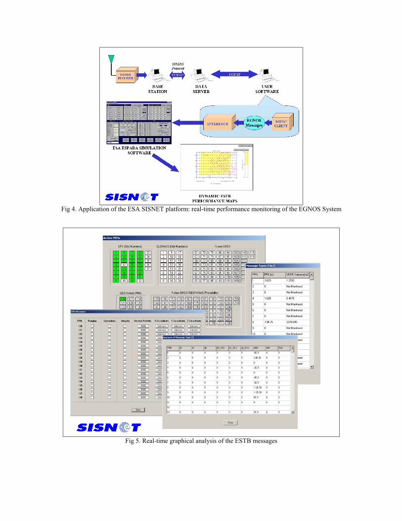
Fig 4. Application of the ESA SISNET platform: real-time performance monitoring of the EGNOS System
Fig 5. Real-time graphical analysis of the ESTB messages

Real-time monitoring of the ESTB performance and SIS status through the World Wide Web
As explained above, the ESA SISNET UAS is able to interact with the ESA ESPADA simulation software, obtaining real-time performance maps of the ESTB. In addition, the UAS is able to calculate the message type corresponding to each received ESTB message. By monitoring the received message types, is possible to determine the ESTB broadcast mode (as defined in [12]), and express it through an icon. Both graphical results are sent to an ESA Web server, enabling their visualization through a Web browser. Fig. 6 depicts the architecture of such a system. This service is available through the ESA ESTB website (http://www.esa.int/navigation/estb). The ESTB broadcast mode icon is updated each five minutes, while the performance map is updated each ten minutes. The web page is automatically refreshed each five minutes, acting as a real-time monitoring tool. A section of that page is shown in Fig. 7.
Fig 6. Real-time monitoring of the ESTB performance and SIS status through the World Wide Web.
EGNOS-Augmented Positioning through the Internet
SISNET can grant noteworthy advantages to the GPS land-user community. A user equipped with a GPS receiver and a GSM / GPRS modem can access the SISNET services, thus being able to benefit from the EGNOS augmentation signals, even under situations of GEO blocking. Fig. 8 shows the architecture of a SISNET-based solution responding to that objective. In this kind of applications, the UAS is habitually embedded in a vehicle, and the access to the Internet (and hence, to SISNET) is established by means of the GSM / GPRS wireless network. The processing stage of the UAS is in contact with a GPS receiver, so that pseudo-range measurements can be obtained. In parallel, the processing stage interacts with the DS2DC Client software, which provides the corrections broadcast by the EGNOS system test bed through SISNET. With that information, a set of algorithms can compute the corrected position, notably improving the accuracy of the GPS-only receiver.

Fig 7. A section of the ESTB real-time monitoring Web page
Fig 8. Positioning through the Internet via the SISNET technology

INDUSTRIAL DEVELOPMENTS
After the internal validation of the SISNET concept, the next logical step consists on complementing this work with industrial work. Indeed, several European industries have shown a high interest on the SISNET development. The following are some of the potential projects that will be carried out during 2002 under ESA contracts: - Development of an integrated SISNET receiver, including a GPS receiver and a GSM / GPRS link to the Internet; - Development of a real-time laboratory software environment for the analysis of the ESTB messages, based on the
algorithms developed by the industry; - Improvement of the SISNET network performance; - Demonstrations of SISNET receivers embedded into cars; - Develop software for existing GPS+GSM handsets, enabling them to access SISNET; - Perform tests of the accuracy obtained via SISNET in urban areas. SUMMARY
With this paper we have introduced the ESA SISNET project, a platform that allows the access to the EGNOS Satellite Navigation services through the Internet. A first prototype of the SISNET concept has been set-up by the ESA GNSS-1 Project Office, based on the use of the EGNOS system test bed. This first version uses a PC computer to implement the user equipment software, and the connection to the Internet is achieved using a LAN environment (via a proxy server). The SISNET platform has been described here in some detail, starting from a top-level view, and then focusing each of the main components of the system. Four examples of SISNET-based applications have been described, demonstrating the powerful capabilities of this new technology. In addition, the interest of the industry on the development of SISNET applications has been highlighted, by presenting some proposals of co-operation, currently under assessment. SISNET combines the power of EGNOS and the almost unlimited potential of the Internet. The authors have confidence in the success of such a powerful mixture, which will probably open a large amount of applications for satellite Navigation. REFERENCES
[1] ESA ITT AO/1-3750/NL/DS, "Integration of EGNOS and Terrestrial Regional Networks," ASTE Work plan 2001. [2] L.Gauthier, P.Michel, J. Ventura-Traveset and J.Benedicto, “EGNOS: the first step of the European contribution to the Global Navigation Satellite System," ESA Bulletin, No. 105, Feb. 2001 [3] H. Secretan, J. Ventura-Traveset, F. Toran, G. Solari and S. Basker, “EGNOS System Test Bed Evolution and Utilisation,” GPS ION 2001, Sept. 2001, Salt Lake City, USA. Awarded as the best paper presentation in the area of SBAS systems by The Institute of Navigation. [4] ESTB News, ESA Newsletter, Issue 1, May 2001. [5] ESTB News, ESA Newsletter, Issue 2, September 2001. [6] F. Toran, J. Ventura-Traveset and J.C. de Mateo, "ESPADA 3.0: An innovative EGNOS Simulation Tool Based on Real Data," ESA Journal preparing for the Future, in press. [7] A. García, C. Garriga, P. Michel and J. Ventura-Traveset, "EGNOS Simulation Tool for Performance Assessment and Design Analysis (ESPADA)," ESA Journal preparing for the Future, Vol. 7, No.4, December 1997. [8] F. Toran, "Advanced Simulation Tool for Satellite Navigation: from Radio Frequency to Positioning Using Real Data," Research Work Essay, Directed by Dr. Diego Ramirez (University of Valencia) and Dr. Javier Ventura-Traveset (ESA), July 2001. [9] F. Toran and J. Ventura-Traveset, "GPS / EGNOS Comparative under Several Visibility Conditions," ESA internal technical note, Ref. E-TN-PFM-E-0020-ESA, Issue 1, Rev. 0, November 2001. [10] "Standard Positioning Service GPS," US DoD, Washington, October 2001. [11] F. Toran and J. Ventura-Traveset, "SISNET User Interface Document," ESA document, Ref. E-RD-SYS-E31-010, Issue 1, Rev. 0, November 2001. [12] N. Suard, "ESTB SIS User Interface Description," Issue 0, Rev. 1, Ref. E-TN-ITF-E31-0008-ESA. [13] "Service Volume Model Simulation Assumptions for SBAS Performances," Interoperability Working Group (IWG), Ref. IWG/SVM/2.0, Issue 2, Rev. 0, June 2000.