international journal on public works, ports & … works, ports & waterways developments...
TRANSCRIPT

International Journal on Public Works, Ports & Waterways DevelopmentsNumber 85 • December 2001
International Association of Dredging Companies

Terra et Aqua – Number 85 – December 2001
Terra et Aqua is published quarterly by the IADC, The International Association of Dredging Companies.The journal is available on request to individuals or organisations with a professional interest in thedevelopment of ports and waterways, and in particular, the associated dredging work.The name Terra et Aqua is a registered trademark.
EditorMarsha R. Cohen
Editorial Advisory CommitteeH.A.J. Fiers, Chairman P.J.A. Hamburger H.W.J. PoieszH.L.H. Smink R. Vidal Martin P.G. RolandK. de Groot F.A. Minderhoud H. Cami
IADC Board of DirectorsR. van Gelder, President O. Nakagome, Vice President C. van Meerbeeck, TreasurerP.G. Roland M. Montevecchi G. VandewalleD. Eicke J.J. Koeman
Please address inquiries to the editor.Articles in Terra et Aqua do not necessarily reflect the opinion of the IADC Board or of individual members.
© 2001 IADC, The NetherlandsAll rights reserved. Electronic storage, reprinting or abstracting of the contents is allowed for non-commercial purposes with permission of the publisher.
ISSN 0376-6411
Typesetting and printing by Opmeer Drukkerij bv, The Hague, The Netherlands.
Front cover:
The new FIDIC Contract for Dredging and Reclamation Works addresses the risksinvolved with modern mega dredging projects, which can involve many vessels working day and night (see page 3).
IADCP.J.A. Hamburger, Secretary GeneralDuinweg 212585 JV The Hague, The NetherlandsTel. 31 (70) 352 3334, Fax 31 (70) 351 2654E-mail: [email protected]://www.iadc-dredging.com
International Association of Dredging Companies

Terra et Aqua – Number 85 – December 2001
CO N T E N T S
2 Editorial
3 A Contract for “Just Digging a Hole”
Constantijn P.I.M. Dolmans
To meet the specific needs of the dredging industry, FIDIC has developed a new Form of Contract for Dredging and Reclamation Works.
11 Restoration and Development Project of South Lake of Tunis and its Shores
Jan Vandenbroeck and Ben Charrada Rafik
At the request of the Tunisian Government, a consortium of five dredging contractors has regenerated one of the most eutrophic lagoons in the world into a living lake.
21 The Gorai Re-Excavation Project
Jorrit K. de Groot and Pieter van Groen
After three seasons of dredging, the catastrophic drying up of the Gorai River in Bangladesh has been reversed making shipping and fishing possible once again.
26 Books/Periodicals Reviewed
Three new books from Thomas Telford Publishing in the UK are profiled.
29 Seminars/Conferences/Events
The 2002 season of conferences is presented, featuring a Call for Papers for the WEDA XXII Conference.

Terra et Aqua – Number 85 – December 2001
2
EDITORIAL
The attacks on New York, Washington, DC and near Pittsburgh sent a shockaround the world which will be felt for a long time. Firstly, our sympathy goes outto all the families of the victims of this tragedy. Secondly, as an industry, we areespecially aware of our colleagues at the Port Authority of NewYork/New Jersey
who were housed in the World Trade Center and withwhom we have shared many professional exchanges atmeetings and social gatherings.
One of those occasions was the World DredgingConference in Las Vegas, Nevada. At that meeting, inthe IADC booth, the industrial artist Paul Kerrebijnwas busy painting his impressions of ports and dredgingvessels. The cover of the September 1998 issue of Terrafeatured one of his works depicting the skyline of NewYork and a ship dredging its harbour. Little could weknow that only three short years later this paintingwould become a historical record of New York’s World
Trade Center, “the twin towers,” and harbour as they no longer exist.
We in the dredging industry, be it in Europe, Asia or the Americas, are dedica-ted to building — to constructing new ports, harbours, container terminals; torestoring and maintaining waterways; to help prepare for the laying of gas and oilpipelines; to reclaiming land for housing, recreation and industrial complexes. Allthat we do is based on improving infrastructure to maintain and expand economicopportunities and to create them where they did not exist. The devastation wehave witnessed on September 11th is contrary to all that we stand for.
Despite the worldwide repercussions, the turbulence in financial markets, andan atmosphere of uncertainty, the dredging industry will continue to push forward.For the true means of conquering the forces of destruction are to remain steadfastin our belief in progress, in technology and in the creative energy of engineering.
Robert van GelderPresident, IADC Board of Directors

Abstract
In 1999 FIDIC published four new standard forms ofcontract: EPC Turnkey Projects; Plant and Design-Buildwith Design by the Contractor; Construction withDesign by the Employer (the former FIDIC Red Book);and the Short Form of Contract. This new work doesnot meet specific dredging and reclamation workneeds. Consequently, FIDIC formed a Task Group toexamine the possibility of a contract customised for thedredging industry. In the tradition of FIDIC, the new“FIDIC Form of Contract for Dredging and ReclamationWorks” has been carefully developed by this TaskGroup and is now available in a test edition.
Special thanks go to Philip Jenkinson from WS Atkins(Dredging Task Group Leader) for his valuable comments, and to the other members of the FIDICDredging Task Group: Tony Sanders of Mouchel,Edward Corbett of Corbett & Co. on behalf of FIDICand Pieter Boer of Royal Boskalis Westminster onbehalf of IADC.
Introduction
For the smooth execution of a dredging project onecannot do without a strong and clear contract. The objectives of this contract should be (Bray et al.): - to describe accurately the work to be done and the
conditions under which it is to be done;- to apportion risk; and- to provide a fair and equitable method of payment
for that work when it is completed satisfactorily.
FIDIC, the International Federation of Consulting Engineers, has a long history in publishing standardforms of contract for engineering construction. FIDICwas founded in 1913 as an association for nationalmember associations in engineering and has at presenta membership coming from nearly 70 countries. Theirfirst standard forms were published in 1957. Editions in1969 and in 1977 of the so-called Red Book includedexplicit provisions for dredging and reclamation works.
A Contract for “Just Digging a Hole”
Constantijn P.I.M. Dolmans
A Contract for “Just Digging a Hole”
3
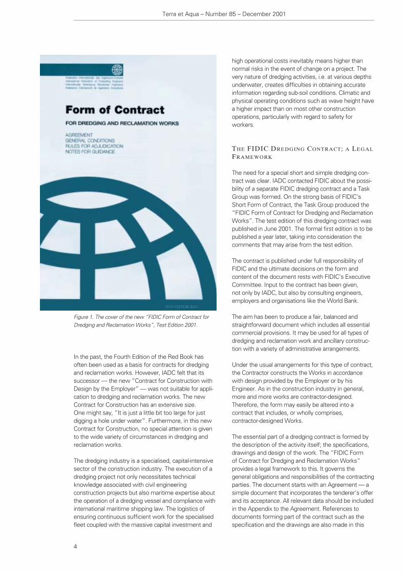
However, the Fourth Edition of the Red Book in 1987did not include these dredging provisions. To meet the specific requirements of dredging projects, IADC(International Association of Dredging Companies)published a “Users Guide” to this Fourth Edition ofFIDIC’s Red Book in 1990. This cooperation betweenthe IADC and FIDIC provided the basis for developingthe present publication (Figure 1).
THE NEW FIDIC CONTRACTS
In 1999 FIDIC published four new standard forms ofcontract, the Conditions of Contract for: - EPC Turnkey Projects; - Plant and Design-Build with Design by the Contractor; - Construction with Design by the Employer
(the former FIDIC Red Book); and - the Short Form of Contract.
Constantijn Dolmans graduated fromLeiden University in fiscal law (1995)and has a professional degree in insurance. He had worked as a cost-controller for BFI (currently SITA, a waste company) since 1992, when in1997 he joined IADC. One of his firsttasks was to comment upon FIDIC’sdraft for a new “Conditions of Contractfor Construction” and he then became amember of FIDIC’s Dredging andReclamation Contract Task Group. Constantijn Dolmans
In the past, the Fourth Edition of the Red Book hasoften been used as a basis for contracts for dredgingand reclamation works. However, IADC felt that itssuccessor — the new “Contract for Construction withDesign by the Employer” — was not suitable for appli-cation to dredging and reclamation works. The newContract for Construction has an extensive size. One might say, “It is just a little bit too large for justdigging a hole under water”. Furthermore, in this newContract for Construction, no special attention is givento the wide variety of circumstances in dredging andreclamation works.
The dredging industry is a specialised, capital-intensivesector of the construction industry. The execution of adredging project not only necessitates technical knowledge associated with civil engineering construction projects but also maritime expertise aboutthe operation of a dredging vessel and compliance withinternational maritime shipping law. The logistics ofensuring continuous sufficient work for the specialisedfleet coupled with the massive capital investment and
high operational costs inevitably means higher thannormal risks in the event of change on a project. Thevery nature of dredging activities, i.e. at various depthsunderwater, creates difficulties in obtaining accurateinformation regarding sub-soil conditions. Climatic andphysical operating conditions such as wave height havea higher impact than on most other construction operations, particularly with regard to safety for workers.
THE FIDIC DREDGING CONTRACT; A LEGAL
FRAMEWORK
The need for a special short and simple dredging con-tract was clear. IADC contacted FIDIC about the possi-bility of a separate FIDIC dredging contract and a TaskGroup was formed. On the strong basis of FIDIC’sShort Form of Contract, the Task Group produced the“FIDIC Form of Contract for Dredging and ReclamationWorks”. The test edition of this dredging contract waspublished in June 2001. The formal first edition is to bepublished a year later, taking into consideration thecomments that may arise from the test edition.
The contract is published under full responsibility ofFIDIC and the ultimate decisions on the form andcontent of the document rests with FIDIC’s ExecutiveCommittee. Input to the contract has been given, not only by IADC, but also by consulting engineers,employers and organisations like the World Bank.
The aim has been to produce a fair, balanced andstraightforward document which includes all essentialcommercial provisions. It may be used for all types ofdredging and reclamation work and ancillary construc-tion with a variety of administrative arrangements.
Under the usual arrangements for this type of contract,the Contractor constructs the Works in accordancewith design provided by the Employer or by his Engineer. As in the construction industry in general,more and more works are contractor-designed. Therefore, the form may easily be altered into a contract that includes, or wholly comprises, contractor-designed Works.
The essential part of a dredging contract is formed bythe description of the activity itself; the specifications,drawings and design of the work. The “FIDIC Form of Contract for Dredging and Reclamation Works” provides a legal framework to this. It governs the general obligations and responsibilities of the contractingparties. The document starts with an Agreement — asimple document that incorporates the tenderer's offerand its acceptance. All relevant data should be includedin the Appendix to the Agreement. References todocuments forming part of the contract such as thespecification and the drawings are also made in this
Terra et Aqua – Number 85 – December 2001
4
Figure 1. The cover of the new “FIDIC Form of Contract forDredging and Reclamation Works”, Test Edition 2001.
Bank. However, if there is no need for an Engineer inthe Contract — in smaller projects an experiencedEmployer may want to act for himself directly — theFIDIC Dredging Form can be easily adjusted to a con-tract without an Engineer.
In line with the other major FIDIC Contracts, the Engi-neer is no longer expected to be an impartial person ororganisation. After years of discussion, FIDIC brokewith the tradition of the impartial Engineer. The closerelationship between the Employer, who pays the bill,and the Engineer made the independence of the Engi-neer questionable in practice. It does not mean that inthe new FIDIC Contracts the Engineer may do what-ever he wants. The Dredging Form states:
“The Engineer and any assistants shall exercise theirduties and authority in a fair manner in accordance withthe Contract”.
If disputes or differences between the Employer andthe Contractor, including dissatisfaction with decisionsof the Engineer, cannot be settled amicably, the FIDICDredging Form provides for resolution of the dispute bya Dispute Adjudication Board (DAB). This DAB has infact taken over the impartial decisional role of theEngineer in case of disputes. Should the decision of theDAB not satisfy one or both parties to the Contract, the FIDIC Dredging Form provides for internationalarbitration under the Rules of Arbitration of the Interna-tional Chamber of Commerce.
RISKS AND RESPONSIBILITIES
Within the execution of a dredging project there maynever be a situation in which all required information isavailable. Unexpected events, whether caused bynature or people, may occur. These uncertain factors
Appendix. The General Conditions are expected tocover all essential elements of the legal framework.
Nevertheless, every situation is unique. Modificationsmay be required in some jurisdictions or may be neces-sary to suit special circumstances. Users are able tointroduce Particular Conditions if they wish to handlesuch special cases or circumstances.
CONTRACT PARTIES AND THE ENGINEER
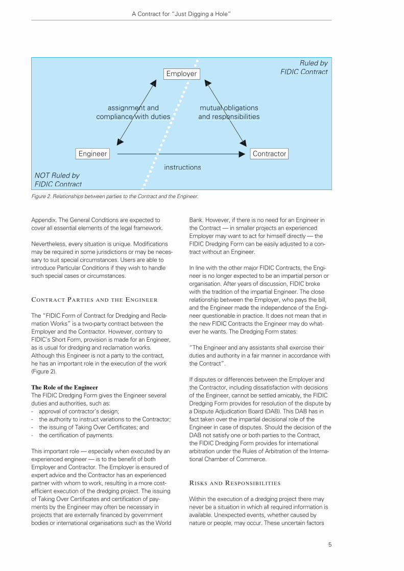
The “FIDIC Form of Contract for Dredging and Recla-mation Works” is a two-party contract between theEmployer and the Contractor. However, contrary toFIDIC’s Short Form, provision is made for an Engineer,as is usual for dredging and reclamation works.Although this Engineer is not a party to the contract, he has an important role in the execution of the work(Figure 2).
The Role of the EngineerThe FIDIC Dredging Form gives the Engineer severalduties and authorities, such as:- approval of contractor’s design; - the authority to instruct variations to the Contractor;- the issuing of Taking Over Certificates; and - the certification of payments.
This important role — especially when executed by anexperienced engineer — is to the benefit of bothEmployer and Contractor. The Employer is ensured ofexpert advice and the Contractor has an experiencedpartner with whom to work, resulting in a more cost-efficient execution of the dredging project. The issuingof Taking Over Certificates and certification of pay-ments by the Engineer may often be necessary inprojects that are externally financed by governmentbodies or international organisations such as the World
A Contract for “Just Digging a Hole”
5
Figure 2. Relationships between parties to the Contract and the Engineer.
NOT Ruled byFIDIC Contract
Ruled byFIDIC Contract
instructions
assignment andencompliance with dutiese w
mutual obligationsl oand responsibilitiespo
Engineer Contractor
Employer

Terra et Aqua – Number 85 – December 2001
CONTENTS of the FIDIC FORM OF CONTRACT
for DREDGING and RECLAMATION WORKS
6
AGREEMENT
OfferAcceptanceAppendix
GENERAL CONDITIONS
General ProvisionsDefinitions
The ContractPersonsDates, Times and PeriodsMoney and PaymentsOther Definitions
InterpretationPriority of DocumentsLawCommunicationsStatutory Obligations
The EmployerProvision of SitePermits and LicencesSite DataEmployers Authorised Person
The EngineerThe Engineer’s Duties and AuthorityInstructionsApprovals
The ContractorGeneral ObligationsContractor’s RepresentativeSubcontractingPerformance Security
Design by ContractorContractor’s DesignResponsibility for Design
Defined Risks
Time for CompletionExecution of the WorksProgrammeExtension of TimeLate Completion
Taking-OverCompletionTaking Over CertificateTaking Over Part of the Works
Remedying EffectsRemedying DefectsDredging WorksUncovering and Testing
Variations and ClaimsRight to VaryValuation of VariationsEarly WarningContractor’s Right to ClaimVariation and Contractor’s Claim ProcedureEmployer’s Claims
Contract Price and PaymentValuation of the WorksAdvance PaymentMonthly StatementsInterim PaymentsPayment of Retention - Dredging WorksPayment of Retention - Other WorksFinal PaymentCurrencyDelayed Payment
DefaultDefault by ContractorDefault by EmployerInsolvencyPayment upon Termination
Risk and ResponsibilityContractor’s Care of the WorksContractor’s IndemnitiesLimit of Contractor’s LiabilityForce Majeure
InsuranceArrangementsFailure to Insure
Resolution of DisputesAdjudicationNotice of DissatisfactionArbitration
Index of Sub-ClausesParticular ConditionsRules for AdjudicationNotes for GuidanceAnnexes - Forms of Securities

A Contract for “Just Digging a Hole”
in the execution of construction projects are risks. The purpose of any contract is to allocate these risksbetween the parties to the contract. Risks can best beborne by the party that is best able to handle the risks.Technical risks, for instance, like the safety of a dredg-ing vessel, may be best controlled by the Contractor,whereas an Employer may have better knowledge ofthe specific conditions of the Site where the projecthas to be executed (Figure 3).
Of course, the best means of avoiding unexpectedsituations is by informing each other as adequately aspossible. Therefore the FIDIC Dredging Form gives theEmployer the obligation to supply the Contractor withall Site data relevant to the execution of the work priorto tendering. The Contractor is responsible for theinterpretation of these data and for making thoroughenquiries as far as practicable taking into account costand time.
Sometimes one party can more easily fulfil an essentialcondition for the execution of the project than the otherparty. In dredging projects the Employer, for instance a port authority, can often obtain the permits andlicences needed for the execution of the work morereadily. The FIDIC Dredging Form therefore makes theEmployer responsible for this activity.
Figure 3. Contractor’s and Employer’s shares of the risks andduties: the more risk for the Contractor the higher the price.
Figure 4. Major dredging projects today often involve multiplevessels from several companies, working 24 hours a day, 7days a week. The FIDIC Form of Contract addresses the needfor clarity in contractual agreements amongst all parties.
Contractor's share of risk & duties
Employer's share of risk & duties
Contract Price
Low High
LowHigh
HighLow

Of course, circumstances differ from project to project(Figure 4). The allocation of risk must fit the specificproject and the General Conditions of the FIDIC Dredging Form should be adjusted by Particular Conditions when necessary. However, the allocation ofrisk should remain fair and practicable. In a projectwhere the Employer is responsible for almost everything, there is little incentive for optimal performance by the Contractor. On the other side ofthe balance, an Employer that transfers all the risks andduties to the Contractor will have to pay a very highprice. In that case there is little flexibility for variationand the project will certainly be expensive.
LiabilityThe fact that one party bears the risk for an event thathappens or has not fulfilled his duty — in other wordsthat party is responsible — does not automaticallymean the party is liable for the consequences and thatthese consequences result in a valid claim under thecontract. The Dredging Form is clearer on this subjectthan the other FIDIC Forms of Contract. A clear view ofrisks and liability is of course very important in theexecution of dredging projects where small things canhave major consequences in time and money.
Responsibility may lead to a liability when a party suffersa loss as a consequence of inappropriate action of theresponsible party. Sometimes, when a party suffers aloss as a consequence of certain events like adverseclimatic conditions, this may also lead to liability of theresponsible party (Figure 5). When a party is liable heshould indemnify the other party for his loss accordingto the conditions of the contract. The way the indemnification — a valid claim — should be calculatedmay already have been agreed in the contract, particularly in the Appendix.
Insurance arrangements may cover the indemnifica-tions that have to be paid by one party to the other. The general provision in the FIDIC Dredging Form isthat the Contractor effects these insurances before thework starts. The FIDIC Dredging Form takes care of thespecific needs in dredging projects related to insurance.
In general, the marine insurance policy of the Contractorwill cover hull and machinery and often liability for thedredging vessels. For dredging works, insurance of theWorks, Materials, Plant and Fees (as in a normal Con-struction All-Risk or Contract Works Insurance) is notpossible. You cannot insure a hole under water. Butwhen non-dredging works are involved, the FIDICDredging Form also requires insurance of these duringthe construction. Of course, damage to other propertyof the Employer, death or injury to the Employer, Engineer or their personnel and third-party liabilityshould also be insured under the FIDIC Dredging Form.
Terra et Aqua – Number 85 – December 2001
8
Members ofthe FIDICDredgingTask GroupPhilip Jenkinson graduated from Oxford Universityin Engineering Science, qualified as a Chartered CivilEngineer, and is now a Principal Consultant with WS Atkins. He became Task Group leader forFIDIC’s Short Form of Contract and most recentlyleader of the Dredging and Reclamation ContractTask Group.
Tony Sanders OBE is a chartered quantity surveyorand Director of Dispute Management of MouchelConsulting, specialised in civil engineering. Prior tojoining the Dredging Task Group, he worked withFIDIC on the Orange Book and the Short Form ofContract. He is a member of the FIDIC President’sList of Approved Adjudicators and the FIDIC List ofExperts.
Edward Corbett MA MSc FCI Arb, studied law atOxford University and is the principal of Corbett &Co, a practice specialising in international construc-tion law. He authored FIDIC Fourth Edition - A Practical Legal Guide and is now working on a Guideto the Orange Book. He is a member of the Interna-tional Bar Association's committee on the FIDICcontract as well as the Task Group for the ShortForm and Dredging Form of Contracts.
Pieter Boer graduated as civil engineer from DelftUniversity (1964),started at the Public WorksDepartment of Rotterdam. He then switched toHydronamic bv and continued his career within theRoyal Boskalis Westminster group, becoming Director of Boskalis International in 1986. Retiredfrom Boskalis, he is currently chairman of IADC’slegal committee and as such was asked to join theDredging Task Group.
Constantijn Dolmans, author of this article, isAssistant to the Secretary General of the IADC andas such was invited to be a member of the Dredging Task Group.
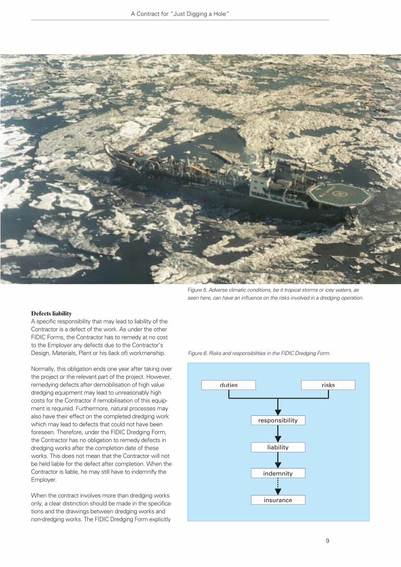
Defects liability A specific responsibility that may lead to liability of theContractor is a defect of the work. As under the otherFIDIC Forms, the Contractor has to remedy at no costto the Employer any defects due to the Contractor’sDesign, Materials, Plant or his (lack of) workmanship.
Normally, this obligation ends one year after taking overthe project or the relevant part of the project. However,remedying defects after demobilisation of high valuedredging equipment may lead to unreasonably highcosts for the Contractor if remobilisation of this equip-ment is required. Furthermore, natural processes mayalso have their effect on the completed dredging workwhich may lead to defects that could not have beenforeseen. Therefore, under the FIDIC Dredging Form,the Contractor has no obligation to remedy defects indredging works after the completion date of theseworks. This does not mean that the Contractor will notbe held liable for the defect after completion. When theContractor is liable, he may still have to indemnify theEmployer.
When the contract involves more than dredging worksonly, a clear distinction should be made in the specifica-tions and the drawings between dredging works andnon-dredging works. The FIDIC Dredging Form explicitly
A Contract for “Just Digging a Hole”
9
Figure 6. Risks and responsibilities in the FIDIC Dredging Form.
duties risks
responsibility
liability
indemnity
insurance
Figure 5. Adverse climatic conditions, be it tropical storms or icey waters, asseen here, can have an influence on the risks involved in a dredging operation.

asks for such a distinction (Figure 7). It may appear tobe in favour of the Contractor that there is no timeperiod allocated for notification of defects after completion of dredging works. However, this conditionis also very much for the benefit of the Employer, asthe existence of a defects notification period for dredging works would certainly increase the contractprice. Nevertheless, the Employer has to be indemnified when he suffers a loss as a consequenceof defects in dredging works due to one of the Contractor’s responsibilities.
Conclusion
Thanks to the cooperation of FIDIC and IADC as well asother organisations and persons, there is once again astandard construction contract that meets the specialrequirements of dredging and reclamation projects. In large projects where dredging and reclamation arejust a part of the work, one of the other FIDIC contractsmay still be suitable. However, even in these cases,the straightforward provisions and clear conditions ofthe FIDIC Dredging Form may help to design particularconditions for these standard contracts to meet specific dredging needs.
The “FIDIC Form of Contract for Dredging and Recla-mation Works” creates a fair and balanced legal frame-work for the optimal execution of dredging and dredg-ing related projects. In general the provisions will suitmost dredging projects. When needed due to specific
circumstances, the FIDIC Dredging Form can easily beadjusted and particular conditions can be added. Inaddition, comments from users may in the futureimprove the FIDIC Dredging Form even further.
References
FIDIC (1999).Conditions of Contract for Construction (for Building and
Engineering Works designed by the Employer);
Conditions of Contract for Plant and Design-Build (for Electrical
and Mechanical Plant and for Building and Engineering Works
designed by the Contractor);
Conditions of Contract for EPC Turnkey Projects;
Short Form of Contract.
FIDIC (2001).Form of Contract for Dredging and Reclamation Works.
Bray, R.N., Bates, A.D. and Land, J.M. (1997).“The Dredging Contract”. Dredging, a Handbook for Engineers,
2nd Editon. UK. pp 313-345.
Terra et Aqua – Number 85 – December 2001
10
Figure 7. Dredging works are often a part of larger construction projects, such as this fixed link bridge in Argentina. The FIDICcontract asks for a clear distinction between dredging and non-dredging works.

showed the presence of approximately 2 million m3 oforganic sediment contaminated by heavy metals suchas Chrome, Copper, Zinc, Iron, Nickel, Aluminium andHydrocarbons. Owing to this, the South Lake hadreached a high level of pollution and eutrophication. Theextreme eutrophication conditions appear in summerwith dystrophic crises characterised by red water, badsmells and high mortality of fish life. In order to solve these pollution conditions, the “Societé d’Etudes et de Promotion de Tunis Sud”(SEPTS) invited LAC SUD 2000 (a consortium of fivecontractors led by Dredging International) to carry out alarge restoration and development programme during aperiod of three years.
The main objectives of this programme consisted ofthe creation of a flushing system of seawater by theconstruction of an inlet and an outlet sluice driven bynatural tidal forces, the confinement in a terrestrial zoneby a vertical PEHD liner of 1 million m3 polluted sedi-ments, the removal of a quantity of 12 million m3 oforganic sediments in order to dredge the lake to adepth of 2 m and the extraction of a quantity of 5 million m3 of sand in order to gain reclamation land on the shores of the lake. Most importantly, however,this project aimed for a total regeneration of the lakeincluding a modification of its shores, its morphologyand its topography.
PRE-DREDGING STUDIES
At the beginning of the project, detailed studies werecarried out by setting up mathematical models forwater circulation and water quality. The water circula-tion has been studied by 2D and 1D models. The 1Dmodel was coupled with an ecological model that wasused to predict water quality and the effect of thecirculation on the ecosystem. The ecological model,based on site measuring and laboratory tests,describes the nutrient seasonal variation in relation with
Abstract
This paper describes the development of the SouthLake of Tunis which has recently been accomplishedby the group LAC SUD 2000 (a consortium of fivedredging contractors) at the request of the TunisianGovernment. The project is within the framework ofthe national development programme of the coastalTunisian lagoons, in an effort to improve the livingconditions in this area and to protect the environmentagainst the various forms of pollution which haveaffected it for more than half a century.
It is amongst the rare projects which introduce viablesolutions for limiting the extent of pollution in one ofthe most eutrophic lagoons in the world. Consideringthe location of the lake within the heart of the town ofTunis City, the project will offer to Tunis centre anopening onto the sea, giving it a whole different look.The history of the Lake Tunis, its location before thedevelopment works, the after-project results and thework volume executed during the project period willalso be discussed here.
The works were completed within the contractualperiod and a programme monitoring water quality willfollow the project during a maintenance period of twoyears and a guarantee period of five years.
For information about the remediation of the NorthLake of Tunis see Terra, number 49, September 1992.
Introduction
The South Lake of Tunis is a shallow lake located in thenorth of Tunisia at the east side of Tunis City. Before theworks described here were implemented, all rainwaterand wastewater of south Tunis City and Ben Arousindustrial zone were discharged into this lake. Theinvestigations carried out before the start of the project
Restoration and Development Project of South Lake of Tunis and its Shores
Jan Vandenbroeck and Ben Charrada Rafik
Restoration andDevelopment Project ofSouth Lake of Tunis andits Shores
11
Environment

Ben Charrada Rafik
Jan Vandenbroeck
the macro algal growth and nutrient release from bottom sediment.
Hydraulic study showed for the retained dredging planthat the water circulation in the lake will be homoge-nous and the lake water will be regenerated in a shorttime. The residence time will be from 4 to 7 days as afunction of the tide and the wind.
The prediction of water quality carried out by the eco-logical model showed that the lake can be regeneratedwith the new flushing system. The nutrient contents inthe lake will be comparable to those in the Tunis Gulf,the bottom concentration of macro algae will bereduced and water will be well oxygenated. This willimprove the situation of the lake by eliminating redwaters and all sources that had negative effects onwater quality before the works.
GEOGRAPHIC SITUATION
The South Lake of Tunis belongs to a Mediterraneanlagoon complex including the North Lake and the navi-gation canal. This complex belongs to the set of thecoastal Tunisian lagoons and is located at the bottom ofthe Gulf of Tunis which is located on the south part ofthe Sicily-Tunisian canal. The South Lake constitutes thesouth part of this complex and it is separated from the
Terra et Aqua – Number 85 – December 2001
12
Figure 1. Geographic localisation of the South Lake of Tunis.
Jan Vandenbroeck received his degree in CivilEngineering from the University of Ghent(Belgium). He joined an affiliate of the DEMEGroup in 1989 and has worked within thisgroup since. From 1998 to summer 2001, hewas Project Manager of the group LAC SUD2000 for Dredging International NV. He ispresently Co-Project Manager of MarineWorks PORT 2000 Le Havre (France).
Ben Charrada Rafik was involved with therestoration and development of both theNorth and South Lakes of Tunis and hasextensive experience in management of waterand environmental problems. He obtained hisDoctorate in Hydraulic Engineering in 1997,basing his thesis on his study of hydrodynamicflows in the Tunisian coastal ecosystem.
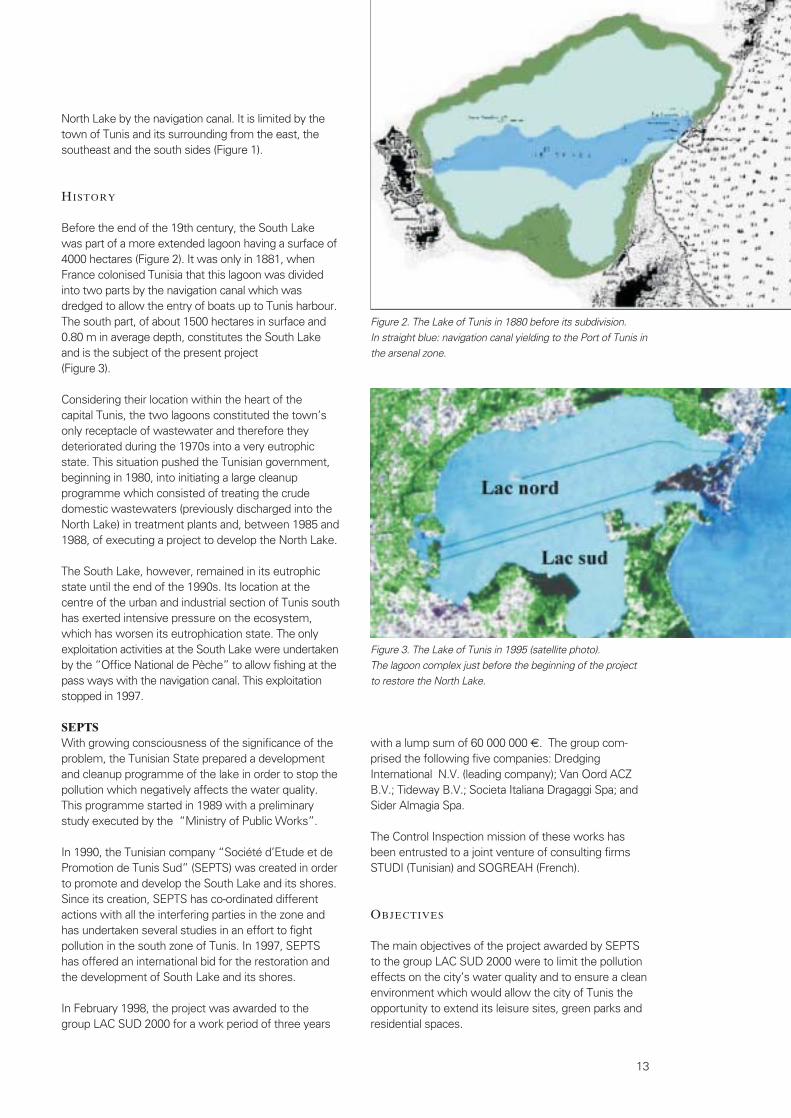
North Lake by the navigation canal. It is limited by thetown of Tunis and its surrounding from the east, thesoutheast and the south sides (Figure 1).
HISTORY
Before the end of the 19th century, the South Lake was part of a more extended lagoon having a surface of4000 hectares (Figure 2). It was only in 1881, whenFrance colonised Tunisia that this lagoon was dividedinto two parts by the navigation canal which wasdredged to allow the entry of boats up to Tunis harbour.The south part, of about 1500 hectares in surface and0.80 m in average depth, constitutes the South Lakeand is the subject of the present project (Figure 3).
Considering their location within the heart of the capital Tunis, the two lagoons constituted the town’sonly receptacle of wastewater and therefore theydeteriorated during the 1970s into a very eutrophicstate. This situation pushed the Tunisian government,beginning in 1980, into initiating a large cleanup programme which consisted of treating the crudedomestic wastewaters (previously discharged into theNorth Lake) in treatment plants and, between 1985 and1988, of executing a project to develop the North Lake.
The South Lake, however, remained in its eutrophicstate until the end of the 1990s. Its location at thecentre of the urban and industrial section of Tunis southhas exerted intensive pressure on the ecosystem,which has worsen its eutrophication state. The onlyexploitation activities at the South Lake were undertakenby the “Office National de Pèche” to allow fishing at thepass ways with the navigation canal. This exploitationstopped in 1997.
SEPTSWith growing consciousness of the significance of theproblem, the Tunisian State prepared a developmentand cleanup programme of the lake in order to stop thepollution which negatively affects the water quality.This programme started in 1989 with a preliminarystudy executed by the “Ministry of Public Works”.
In 1990, the Tunisian company “Société d’Etude et dePromotion de Tunis Sud” (SEPTS) was created in orderto promote and develop the South Lake and its shores.Since its creation, SEPTS has co-ordinated differentactions with all the interfering parties in the zone andhas undertaken several studies in an effort to fightpollution in the south zone of Tunis. In 1997, SEPTShas offered an international bid for the restoration andthe development of South Lake and its shores.
In February 1998, the project was awarded to thegroup LAC SUD 2000 for a work period of three years
13
with a lump sum of 60 000 000 €. The group com-prised the following five companies: Dredging International N.V. (leading company); Van Oord ACZB.V.; Tideway B.V.; Societa Italiana Dragaggi Spa; andSider Almagia Spa.
The Control Inspection mission of these works hasbeen entrusted to a joint venture of consulting firmsSTUDI (Tunisian) and SOGREAH (French).
OBJECTIVES
The main objectives of the project awarded by SEPTSto the group LAC SUD 2000 were to limit the pollutioneffects on the city’s water quality and to ensure a cleanenvironment which would allow the city of Tunis theopportunity to extend its leisure sites, green parks andresidential spaces.
Figure 2. The Lake of Tunis in 1880 before its subdivision. In straight blue: navigation canal yielding to the Port of Tunis inthe arsenal zone.
Figure 3. The Lake of Tunis in 1995 (satellite photo). The lagoon complex just before the beginning of the project to restore the North Lake.

The project should ensure:- the elimination of stagnation zones and the renewal
of the lake waters in an adequate time period;- a maximal oligotrophic character, being highly mixed
with sea water;- avoiding the development of short cycle algae (type
Ulva and Enteromorpha-originating from putrefactionand anoxia yielding to eutrophication);
- the elimination of bad odours and their origins; and- a good physico-chemical quality of the waters,
in conformity with certain criteria related to those ofthe Tunis Gulf.
STATE OF THE LAKE BEFORE THE PROJECT
The development works of the lake were preceded by assessment measures of the site by SEPTS beforethe project as well as by LAC SUD 2000 during thestart-up period of the works. These investigations haveconcerned:- the identification of the effluents;- the hydraulic situation;- the ecological situation; and- the sediments quality.
The effluentsThe downhill basin of the South Lake has a total area of about 4000 hectares, of which 1500 hectares areoccupied by the industrial zones of Ben Arous, Megrine , Bir El Kasaa and Rades, regrouping about650 industrial units. The rainfall and the industrialwaters of these zones are fed into the lake at twodifferent locations:- the first diverse at the east section using Bir El
Kasaa canal; and- the second at the west by Ben Arous and Megrine
channels.
The shoreline of the South Lake is run by a belt canal,which is destined for the drainage of rainfall waters andfor the protection of Megrine against water rise. These channels flow into the lake rainfall water duringrainy periods and industrial wastewaters during normaltimes. The industrial waters discharged into the lakecome from jeans-washing water factories, various foodindustry units and others. The industrial flow rates wereestimated to be about 3000 m3/day for the canal of Bir El Kasaa and about 2500 m3/day for Ben Arousdischarge canal.
The investigations undertaken have shown that thesewaters are polluted with heavy metals such asChrome, Copper, Zinc, Iron, Nickel, Aluminium andHydrocarbons. A treatment station under constructionwill be used to treat such waters. During the lakedevelopment works, these waters were deviated via abelt canal towards the Tunis harbour.
Hydraulic situationBefore the project, the lake did not maintain internalcirculations and its waters were pseudo-stagnant. It communicated with the sea via the Rades Canal andwith the navigation channel by three passes that werecalled Fisheries P4, P5 and P7. The exchanges with theGulf of Tunis were very small, however, the exchangeswith the navigation channel were relatively more important. The waters were pseudo-stagnant andcirculations were only constrained at the area near thepasses. Figure 4 represents the circulation state before
14
Figure 4. State of the circulation in the South Lake of Tunis just prior to the project.

STUDIES
The development project entrusted to the LAC SUD2000 group has included, besides the works, prepara-tion of studies during the first phase of the project.These studies concern topics related to the hydro-dynamic, water quality and contaminated sediments. The hydrodynamic and water quality were studied byAveco BV with the collaboration of HR Wallingford andthe NIOO Institute.
HydrodynamicsThe solution adopted consisted of introducing a flushing system which could allow a continuous
the works using a 2D hydrodynamic model executed within the framework of the developmentproject.
Ecological situation of the lake The effluents in the lake have yielded to very highpollution, which accelerated starting in the 1970s andwas getting progressively worse during the 1990sowing to the rapid evolution of urbanism and industrial-isation. This situation was a result of a very higheutrophication which was characterised, especiallyduring the summer, by dystrophic crises with theappearance of red water phenomenon and the odoursdetectable within the whole zone of the south TunisCity.
This phenomenon was the result of the decompositionof large quantities of macro-algae of the type Ulva rigida(Figure 5), which was a dominant nitrophile speciesdeveloping in the lake (concentration could reach 10 kg/m2). These summer dystrophic crises werecharacterised by a low rate of dissolved oxygen, a verylow pH, high salinity and high contents of phosphorusand nitrogen followed by a massive mortality of fishes(Figure 6).
The investigations undertaken about the physico-chemical quality of the water over a one-year periodbefore the start of the project have revealed valuesproving a high eutrophication. The organic-nitrogenvaried between 1500 and 3237 mgN/l, representingabout 80% of the total nitrogen, the remaining accountbeing present in the form of ammoniacal nitrogen.
The total phosphorus was also high and had reachedvalues around 1000 mgP/l. These eutrophication condi-tions had yielded to a very severe natural selection ofthe ecosystem populations. At the zoological level, the benthic species were subject to a progressivedecline starting from the zones close to the canal ofRades and the fisheries (the side of the navigationcanal) of the number of species until the major confine-ment zones located at the level of the east and westareas.
Quality of the sediments The South Lake sediments were also subject to different investigations in 1997 and 1998. The samples,collected at 26 sampling stations distributed over thewhole lake, had revealed contamination by heavymetals such as Chrome, Copper, Zinc, Iron, Nickel,Aluminium and by Hydrocarbons at the two dischargeeastern and western coves. The heavy metal pollutionconcerns mainly the sediments at the superior level(0.25 m) in the eastern cove, whereas within, thewestern cove, the pollution was found over a surfacelayer of 50 cm. Figure 7 shows the spatial distribution of this pollution.Table I presents the contaminated sediments quantities
Restoration and Development Project of South Lake of Tunis and its Shores
15
Figure 5. Ulva rigida: the dominant macroalgae species in theSouth Lake before the works.
Figure 6. Fish deaths at the South Lake shores during thesummer dystrophic crisis.

regeneration of the lake waters without allowing them to be stagnant within the sites. This solution wasensured by the two following actions:- The construction of two sluices, driven by the tidal
forces. The first, located in Rades, represents theinlet sluice and it allows the entrance of seawaterinto the lake during high tides. The second one (the outlet sluice) is placed in Tunis and permits thelake waters to exit towards the navigation canalduring low tides.
- The use of a geometric shape particular to the lakeallowing a homogeneous circulation without localstagnation. This was ensured by the reduction of thelake surface from 1500 to 710 hectares, thereforeavoiding the east and west coves which constitutedthe two major stagnation zones.
The studies were undertaken by using 2D and 1Dhydrodynamic modelling. The results showed that thelake waters can be auto-regenerated in 4 to 7 days with
Terra et Aqua – Number 85 – December 2001
16
Table I. Estimated quantities of the contaminated sediments in the South Lake.
Zone Polluted Thickness of polluted Quantity (m3)surfaces (m2) sediments (m)
Zone 1a (Effluent of Bir El Kassaâ) 180 000 0.25 45 000Zone 1b (Effluent of Bir El Kassaâ) 300 000 0.25 75 000Zone 5a (Effluent of Ben Arous) 850 000 0.50 425 000Lake zone, west side (Effluent of Ben Arous) 1 000 000 0.50 500 000Zone 4 (west side of the lake) 150 000 0.50 75 000
Total 2 460 000 1 120 000
Figure 7. Distribution of the pollution within the sediments and localisation of the effluent points in the lake just before the project.
A specific study about the future of bird life around thelake was carried out with the collaboration of the DutchReporting Commission of Environmental Impact. The solution given by this study was to create areserve for these birds in a permanent wetlands areaon the western side of the lake with a surface of 43hectares (see Figure 12).
Contaminated sedimentsThe presence of a quantity of 1.12 million m3 of sediment contaminated with heavy metals requiredspecial treatment different from that adopted for othertypes of sediments (categories II and III). Despite thefact that this topic was not included within the bidinitially entrusted to the LAC SUD 2000, it was studiedduring the work period conforming to Tunisian legisla-tion (law 96 – 41 of June 1996 relating to the treatmentof polluted solid waste). A number of alternatives werestudied concerning the confinement mode on land overthe lake shores and in the aquatic area placement pit.
The final option was chosen with the collaboration ofthe Tunisian government represented by the “AgenceNationale de Protection de l’Environnement”.
This option, which was applied, includes the followingconfinement modes:
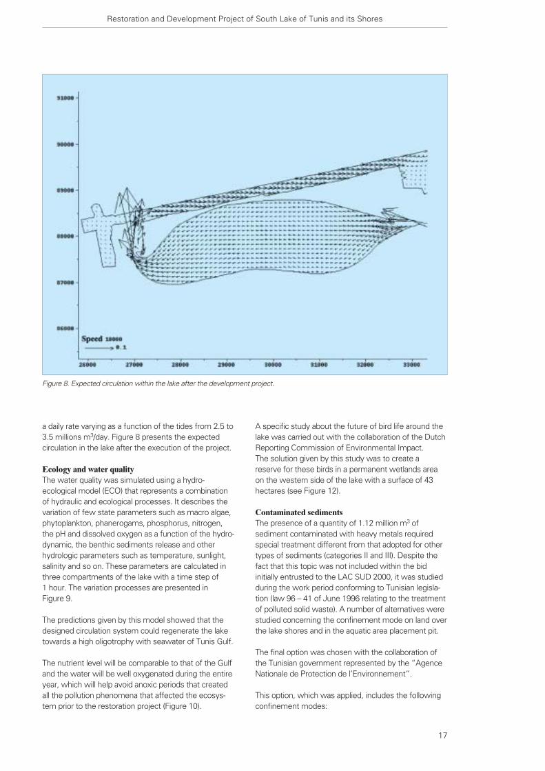
a daily rate varying as a function of the tides from 2.5 to3.5 millions m3/day. Figure 8 presents the expectedcirculation in the lake after the execution of the project.
Ecology and water quality The water quality was simulated using a hydro-ecological model (ECO) that represents a combinationof hydraulic and ecological processes. It describes thevariation of few state parameters such as macro algae,phytoplankton, phanerogams, phosphorus, nitrogen,the pH and dissolved oxygen as a function of the hydro-dynamic, the benthic sediments release and otherhydrologic parameters such as temperature, sunlight,salinity and so on. These parameters are calculated inthree compartments of the lake with a time step of 1 hour. The variation processes are presented in Figure 9.
The predictions given by this model showed that thedesigned circulation system could regenerate the laketowards a high oligotrophy with seawater of Tunis Gulf.
The nutrient level will be comparable to that of the Gulfand the water will be well oxygenated during the entireyear, which will help avoid anoxic periods that createdall the pollution phenomena that affected the ecosys-tem prior to the restoration project (Figure 10).
Restoration and Development Project of South Lake of Tunis and its Shores
17
Figure 8. Expected circulation within the lake after the development project.
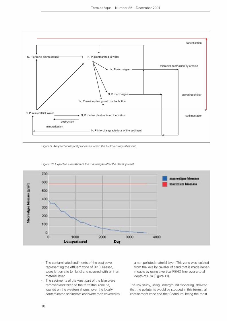
denitrification
microbial destruction by erosion
powering of filter
sedimentation
N, P microalgae
N, P disintegrated in waterN, P organic disintegration
N, P macroalgae
N, P in interstitial Water
mineralisation
N, P interchangeable total of the sediment
N, P marine plant roots on the bottom
N, P marine plant growth on the bottom
destruction
- The contaminated sediments of the east cove,representing the effluent zone of Bir El Kassaa,were left on site (on land) and covered with an inertmaterial layer.
- The sediments of the west part of the lake wereremoved and taken to the terrestrial zone 5a, located on the western shores, over the locallycontaminated sediments and were then covered by
a non-polluted material layer. This zone was isolatedfrom the lake by cavalier of sand that is made imper-meable by using a vertical PEHD liner over a totaldepth of 8 m (Figure 11).
The risk study, using underground modelling, showedthat the pollutants would be stopped in this terrestrialconfinement zone and that Cadmium, being the most
Terra et Aqua – Number 85 – December 2001
18
Figure 9. Adopted ecological processes within the hydro-ecological model.
Figure 10. Expected evaluation of the macroalgae after the development.

- the development of two bridges located over thecanal of Rades, in an effort to maintain a hydraulicsection sufficient to ensure a seawater inlet to the lake;
- the construction of an inlet sluice to Rades and anoutlet one to Tunis marine. Each sluice is made of 8 compartments, separated by vertical concretewalls spaced by 9 m, including a pair of one-waymetallic gates; and
- the development of two targets, in Tunis marine, of1800 mm diameter and equipped by one-way valvesin order to improve the circulation in Tunis harbour:
The South Lake, that previously had an area of 1500hectares, now extends over an area of 710 hectaresand includes a new shoreline of over 13 200 m inlength and an overage depth of 2 m. Figure 12 showsthe new configuration of the South Lake as well as theland reclamation on its shores.
THE MONITORING PROGRAMME
The development works of the South Lake have beenexecuted within the predicted due date of 3 years. The bid predicted a guarantee of the water quality,including the following parameters and criteria:
Dissolved oxygen Tolerated minimum level: 30%of saturation
Total N and P Tolerated maximum concentra-tion for annual average: twice
mobile pollutant, would be displaced by a few centime-tres within a time period of 50 years.
THE EXECUTED WORKS
Taking into account the objectives of the project as wellas the results of the studies undertaken within theframework of this project, the following activities havebeen executed: - the dredging of a quantity of 5 million m3 of sand
category I from the lake, in an effort to create landreclamation site appropriate for housing;
- the dredging of a quantity of approximately 12 million m3 of organic sediment categories II and III,in order to deepen the lake at a homogeneous levelof –2 m NGT;
- the development of about 873 hectares of reclaimedland over the lake shores, including 350 hectares by sand category I and the rest by sediments cate-gories II and III;
- the development of 13 200 m of cavaliers protectedby rip raps extracted from Tunisian stone quarries;
- the installation of 2 100 m of PEHD liner (8 m deep)along the cavalier in order to confine the contamina-ted sediments in the terrestrial zone 5a;
- the development of a seawater feeding canal of 2 100 m in average length and 50 m in averagewidth. This canal includes a section going into thesea of 765 m in length made by two dikes of largerocks of which the northern one is protected by theaccropodes from the waves;
Restoration and Development Project of South Lake of Tunis and its Shores
���� ����
�� � ���
� ����
����� � ���
������� ������������ ��������
����� ������ ������������ ��������
����������� �����
�!����� �����
"�#�$ %�&� ��'�������(���
�����������)*+, ����� �!�����
�� �����
19
Figure 11. Confinement system installed over the west shores of the lake.

that of the gulf water for theeast site and three times for thewest side of the lake
Chlorophyll a Tolerated maximum concentra-tion for annual average: 10 mg/l
PH Must be between 7 and 9 at anytime
Transparency Must be higher that 2 m in calmweather
Algae Absence of accumulation offloating algae on the watersurface
Macro algae biomass Tolerated maximum bottomconcentration: 0.6 kg/m2 in dryweight.
The work period will be followed by a maintenanceperiod of 2 years and a guarantee period of 5 yearsduring which a monitoring programme maintaining theabove parameters will be executed. A chemical labora-tory was installed on-site to this purpose.
Conclusion: Technology Transfer
The aim of this project for a total regeneration of the lakeincluding a modification of its shores, its morphologyand its topography seems to have succeeded.
Moreover, the development project of the South Lakehas allowed the transfer of new technologies toTunisia. This transfer includes hydro-ecological model-ling, management of lagoon water quality and manage-ment of dredged polluted sediments.
The group LAC SUD 2000, with the collaboration of theDutch firm Aveco BV, has organised a training week onhydro-ecological modelling in order to allow the SEPTSengineers to explore and use software for the hydro-ecological provision and the management of the lakewater quality. This software was supplied and installedwithin the terms of the project for SEPTS in two versions: one version, being based on exploitation and calibrated for the sake of the project, and a secondstudy version which could be calibrated upon futurechanges within the lake. A new technique relating tothe confinement of contaminated sea sediments wasalso adopted and constituted the first of its kind inTunisia.
Terra et Aqua – Number 85 – December 2001
20
Figure 12. The new configuration of the South Lake after the restoration works.
Abstract
In the last decades the Gorai River, a branch of theGanges in Bangladesh, has been drying up, causingdifficulties for the people that live along its banks. Thedecrease in water in the river during the dry seasoncaused an increased salinity intrusion into the river,leading to harmful environmental conditions of a largemangrove forest situated at the rivers mouth. To get the river flowing again, a number of solutions wereconsidered. Owing to the extreme morphological activity, the river response to an intervention is veryhard to predict. Therefore investing in permanent struc-tures was considered too high a risk. A better solutionwas found to be dredging a deeper channel at thebifurcation where the Gorai splits off from the Ganges.
After implementation of three dredging seasons, 1998,1999 and 2000, this solution has increased the waterflow in the river, restoring the fish population andallowing year-round shipping.
The authors would like to thank Fred Hoogervorst forthe use of his photographs.
Introduction
The Gorai is one of the most important river branchesin Bangladesh. The river is a branch of the Ganges andis the most important sources of sweet water for thesouthwestern part of Bangladesh. It is also importantfor shipping, fishing and for the ecological environmentof the mangrove forests, the Sundarbans, situatedalong the coast.
Not insignificant is also the household use of the riverwater for the people living along the river’s banks.
During the last decades the flow of the river graduallybegan to slow down. In contrast to the decrease in the(low-water) discharge of the river, the annual sedimen-tation of sand in the river increased. The combination oftoo little water and too much sand led to the lengtheningof the period in which the river was completely dry.
The Gorai Re-Excavation Project
Jorrit K. de Groot and Pieter van Groen
The Gorai Re-Excavation Project
21
After receiving his master degree in civilengineering at the Technical Universityof Delft in 1999, Jorrit de Groot startedworking at Hydronamic, the “in house”engineering company of Boskalis. Spe-cialised in coastal and river engineering,he became a project engineer at theGorai River Re-Excavation project soonafterwards. There he designed andevaluated the works and supervised theon-site survey department. During hisstay in Bangladesh he also worked on afeasibility study of dredging the oldBrahmaputra, a tributary of the Jamuna.
For the last 25 years Pieter van Groenhas been involved in numerous riverrelated projects in Asia. From 1991onwards he participated in several largeriver projects in Bangladesh. He wasdesign engineer for low cost river train-ing works (FAP22) and project managerof the River Survey Project (FAP24) forDelft Hydraulics. Since 1998 he hasworked as site engineer on the GoraiRiver (pilot dredging) for Boskalis.
Jorrit K. de Groot
Pieter van Groen

This drought was catastrophic for all the functions ofthe river. In the last few years the Gorai was dry fromJanuary through April. Shipping was in this period nolonger possible, and the related trade in goods wasdisrupted. The health of the inhabitants of the areaaround the river was threatened because there was noclean water available for household tasks. Because theriver was dry, the salty sea water was able to pushfurther upstream into the riverbed. As a result of thehigher salinity, the river water could no longer be usedfor irrigation for agriculture. In addition, the increase insalinity resulted in a decrease in the biodiversity of themangrove forest.
TREATY BETWEEN INDIA AND BANGLADESH
In order to solve these problems, the Bengali Govern-ment signed a treaty with India in which the distributionof the water from the Ganges between the two countries is regulated. The treaty establishes a certainminimum discharge and as a result of that a certainminimum water level for the Ganges. The treatybecame effective in 1997 and established the circumstances for the restoration of the discharge ofthe Gorai. However, because the top part of the courseof the Gorai was blocked with sediment, there was stillno water flowing through from the main stream, theGanges. In other words, the cork was still in the bottle.
To solve this problem a dredging project was begun in 1998 with the projected duration of two years. The dredging, performed by a joint venture of Boskalis,Dredging International, HAM and VOACZ, was meantto dig a low-water channel in order to restore the low-water discharge of the river. Because the BengaliGovernment attached great importance to these dredging works, the project was given the stamp ofhigh priority (Figure 2).
PURPOSE OF THE DREDGING
Owing to insufficient and limited knowledge of thebehaviour of river systems such as the Gorai-Gangessystem, it was impossible to adequately predict theresponse of the river to the action of dredging.
A secondary aim of the project was therefore to gaininsight into the role that dredging could play in therestoration of the Gorai river in the long run. By inten-sively measuring the behaviour of the river during andafter the dredging a better idea of the response of the river to dredging was achieved, and the ability topredict the response in the long run was improved.
Because alluvial rivers — such as the Ganges and theGorai — consist of beds composed of fine sand, theyare heavily subject to morphological changes. It is thusdifficult to plan a detailed design of the work far inadvance. For this reason a so-called “design and con-struct” contract was chosen, in which both the designof the work as well as its implementation are left to thecontractor. The design, the evaluation of the dredgingworks and the interpretation of the surveyed data weredone by Hydronamic bv, the internal engineering groupof Boskalis.
THE WORKS
At the end of the wet period in October 1998 thedredging work began at the bifurcation where the Goraibranches out of the Ganges (Figure 3). At that point a
Terra et Aqua – Number 85 – December 2001
22
Figure 1. Map of the Gorai River. Project area marked inyellow.

large amount of sedimentary sand was blocking thestream of water into the Gorai. A new low-water channel was dredged at this fork in the river with helpfrom two cutter suction dredgers, the Gemini and the Wombat.
The dredging of the channel took place in a down-stream direction, until the low-water discharge of theriver was restored. The final length of the dredged low-water channel reached a distance of about 20 km fromthe fork of the Gorai branch and the Ganges.
The dredged sand was placed within the high-waterbanks, so that the high-water bed was narrowed andthe flow channel was deepened.
In Bangladesh the dry period is followed by the verywet monsoon season, during which the flowing waterstream carries a great deal of sand along with it. This destroyed part of the dredging work so that anotherdredging intervention was necessary to prevent theriver from drying up.
The second dredging season started in September1999, just after the monsoon was finished. This timeonly one cutter was used. With less effort than the first time, the low-water discharge of the Gorai wasrestored for a second time. This provided evidence thatby dredging the river, the conditions of the river streamcould be restored and that a general improvement in
The Gorai Re-Excavation Project
23
Figure 2. At the request of the Bengali Government dredging of the Gorai took place; interested citizens line the river banks towatch the works.
Figure 3. Bifurcation area of the Ganges and Gorai.
Terra et Aqua – Number 85 – December 2001
24
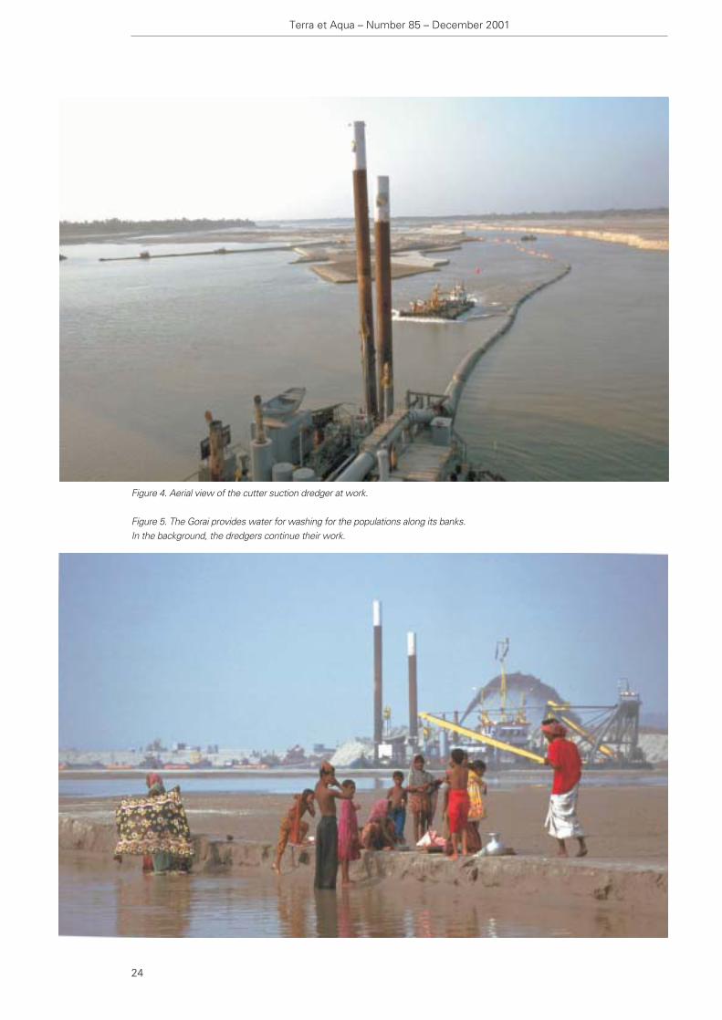
Figure 4. Aerial view of the cutter suction dredger at work.
Figure 5. The Gorai provides water for washing for the populations along its banks. In the background, the dredgers continue their work.

The Gorai Re-Excavation Project
25
the condition of the river was possible. The results ofthe project were so promising that it was decided toextend the project another year.
After the third dredging season — going from Octoberto mid-December 2000 — the low-water dischargerestored itself again, while the dredging effort itselflessened. The condition of the river again demonstratedfurther general improvement.
CONTINUING IMPROVEMENT
Since the start of the dredging project, the volume of sand to be dredged in order to improve the riverdischarge during the dry season has steadily declined.In the first season, going from mid-October to mid-March two suction dredgers removed 9.2 million cubicmetres of sand. In the second season going from mid-September to the end of January, one suction dredgerremoved 5.8 million cubic metres of sand. In the thirddredging season, mid-October to mid-December, only 3.4 million cubic metres were dredged (Figure 4).
Despite the decreasing volumes of sand dredged, theresults in terms of low-water discharge through theGorai have remained the same. Soundings taken fromthe riverbed indicate that the river is slowly restoringitself in response to the dredging. The overall sedimen-tation which the river was experiencing in the yearsprior to the start of dredging has now been turnedaround into an increase in net erosion of the riverbed.
This has resulted in a steady deepening of the flowchannel over the years, leading to an improvement inthe flow of the river and a reduction in the volume ofsand needing to be dredged.
THE FUTURE
Despite the present situation of increased river erosion,and thus a reduction in the annual volumes to bedredged, the future in terms of dredging is uncertain.The from year-to-year varying characteristics of themonsoon, the ever-changing configuration and headingof the Ganges main channel upstream, the bifurcationand the shape of the bifurcation area have great influences on the sedimentation pattern of the Gorai.These factors subsequently influence the volumes tobe dredged. Because these factors are difficult topredict, so are the volumes to be dredged.
It is clear that for the near future it is necessary tocontinue to dredge in order to safeguard the low-waterdischarge of the river. From soundings of the riverbed itseems that during the monsoon the river is re-profilingitself. This means that the deep, narrow dredged chan-nel is transformed by the monsoon into a broader,
shallower channel, which is (still) unable to guaranteethat water will be discharged through the Gorai duringextreme low-water levels in the Ganges.
Another morphological process, which occurs duringthe monsoon, is that shallow spots develop at bendcrossings in the river, which again create obstaclesduring extreme low-water situations. After the monsoon it is then necessary to dredge the flow channel back to a geometry that is capable of low-water discharge.
Conclusion
The conclusion after three seasons of dredging theGorai is that intervention by dredging should be includedin any long-term solutions for the restoration of theriver, and can be seen as an alternative for building anyconventional hard (i.e., stone) constructions in the river.The dredging operation can be seen as a flexible long-term solution for river problems, which — in contrast toconventional options — can anticipate the extremechanges in the morphology of the river system.
As a direct result of the intervention by dredging, wateris flowing once again through the Gorai even in the dryseason. Villagers can use the water of the Gorai towash clothes, to catch fish for a nutritious eveningmeal, and children can play in the river and on its banks(Figure 5). The river can be used the whole yearthrough for shipping so that goods can easily be transported from one village to another. The fish havereturned to the river and the intrusion of salinity hasbeen strongly reduced.
The restoration of low-water discharge has establishedthe prerequisites for an enduring development of theSundarbans. The certainty of sweet surface waterduring the entire year also creates the basic conditionsfor further development of irrigation for agriculture.The availability of surface water during the whole yearcan, with the installation of water purification facilities,be used in the future as a source of drinking water.Because the groundwater in Bangladesh is contamina-ted with arsenic, while the surface water is not, the use of surface water can remove a serious threat topublic health.
In general the conclusion may be drawn that therestoration of low-water discharge of the river, as aresult of these dredging works, have created newchances for further development in southwesternBangladesh.

Guidelines for the Assessment and Planning ofEstuarine BarragesUK Department of Environment, HR Wallingford andEnvironmental Agency. Thomas Telford Publishing,London, UK. 2001. Hardbound, 529 pp., 170x245 mm,illustrated, indexes. £ 75.00.
Edited by Neville Burt and Andrew Rees
The UK Department of Environment, HR Wallingfordand Environmental Agency compiled this book as a jointendeavour. The Department of Environment, which paidfor half the costs, commissioned the research whichforms the basis of the book. The Environmental Agencyfunded the other half. The project was overseen by a steering committee and HR Wallingford was thecontracted research entity.
The objective of the research was to review availableexperience on the design, operation and environmentalimpact of estuarine barrages in order to provide thebest practice design and operational engineering solutions to overcome or mitigate problems andenhance the aquatic and riparian environment.
For the purposes of the research and this book, a barrage is defined as a structure built in an estuary, at a point where it is not less than 15 m wide, with thespecific intention of preventing or modifying tidal propagation.
The book is very well organised and begins with anexcellent and rather comprehensive preface that effectively summarizes the following chapters. Thereare twelve narrative chapters, a chapter of references,eight appendices, and an index. The expansive prefaceserves as a quick read of the subject matter in summaryand thence gives the reader the ability to go directly to the chapter wherein more detailed treatment iscontained. This is a technique not generally seen and itis a very effective means to introduce the casual
readers to the subject and direct the more seriousreaders to their specific areas of concern.
The guidelines presented recommend that future barrage schemes should closely embrace the principlesof sustainable development, thereby insuring that eco-nomic investment and environmental improvements arecongruent. With this as a positive underlying principle,the book is divided into the following chapters:
Chapter 1 contains an introduction to the issues, an amplified list of the issues, a description of appro-priate levels and methods of study, a description ofmonitoring, methods pertaining to the issues, and casestudies.
Chapter 2 presents the chronology for decision-making.It covers pre-feasibility and feasibility studies, detaileddesign, monitoring, long-term ownership and responsi-bility issues and legislative framework.
Chapter 3 is entitled, “Fisheries and conservation”, and has sections on migrating fish, marine fish, invertebrates, birds, habitats and recreation.
Chapter 4 considers water quality both upstream anddownstream of the structure. The effects of salinity,effluent loading, oxygen balance, eutrophication andother effects on water quality are discussed. The chapter also considers recreational water quality andremedial measures that prevent poor water quality.
Chapter 5, “Hydraulics”, describes the principal features of the tidal hydraulic processes in an estuaryand then considers the effect a barrage is likely to have on them. The features discussed include: tides,gravitational circulation and saline intrusion.
Chapter 6 presents morphology or shape of an estuaryand the effects of fluvial and tidal flow as well as theeffects of tidal and fluvial-borne sediments.
Terra et Aqua – Number 85 – December 2001
Charles W. Hummer, Jr.
Books/PeriodicalsReviewed
26

Chapter 7 is a discussion of flood defence regime inthe watercourse. It lists the principal issues regardingflood defence, and its relationship to the functions ofriver authorities, no matter where they may be located.
Chapter 8 discusses the impacts of barrages on estuarine water levels, the interaction with aquifers andthe consequent effects on groundwater. Specificallythe impacts of derogation of water resources, impactson property and stability of bankside structures areenumerated. Potential hazards associated with rise ingroundwater are listed.
Chapter 9 considers navigation and the impacts barrageshave on this function. Because a barrage of any type is designed to obstruct tidal propagation, it naturallyfollows that it will have some impact on navigation.Design parameters, upriver and downriver effects arediscussed at length.
Chapter 10, “Waves”, is a discourse on thoseinstances when waves present a problem for barragesand the protective measures that are in order.
Chapter 11, “Structure”, is divided into sections; issuesconcerned with the structure; design; commissioning;maintenance; and monitoring.
Chapter 12, the final narrative chapter, summarizesresearch priorities drawn from those areas that wereidentified in the study as requiring further research. The greatest single research need is for the monitoringof existing barrages, not just in physical terms but also inthe wider short- and long-term socio-economic implications. In addition, the chapter itemizes sustainable development issues, technical issues and modelling.
Chapter 13 is a comprehensive listing of references.The eight appendices cover planning and environmentallegislation, a number of case studies, and codes, standards and reference manuals, gates, valves andancillary equipment and modelling.
Estuaries have a high conservation environmental andamenity value and are also a limited natural resource,so while the research and the book itself present casestudies related to experiences in the UK, the design,operation, monitoring, modelling and environmentalissues have a universal application. In that regard, this book is a valuable contribution to the internationaltechnical literature and will provide meaningful information for a wide international audience.
Books/Periodicals Reviewed
27
The Global Change? — International Ports Congress1999Proceedings of the international congress organised bythe Institution of Civil Engineers, held in Southampton,UK, on 14-15 June 1999. Thomas Telford Publishing,London, UK. 2000. Hardbound, 16 x 24 cm, 208 pp,illustrated. £ 45.00.
Edited by J. Carmichael
This seemingly small publication is misleading insofaras the relevance and importance of its subject matter.The content and presentation certainly merits far moreconsideration than its modest size would indicate.
The seventeen papers and the keynote summaryrepresent the proceedings of a conference organisedby the ICE in conjunction with IAPH and PIANC. Theycover a wide range of subjects within the context ofthe theme of the congress, “The Global Change?”.Particular attention is given to recent developments indesign and construction methods and how these mustbe economically integrated with operational require-ments and environmental considerations. Also modernprocurement and funding are examined and considera-tion is given to ports in relation to integrated transportsystems.
Beginning with the keynote paper that presents anoverview from the perspective of the UK's Associated British Ports Holdings, the papers cover

design, environmental, operational, and funding issuesrelated to ports and port technology and a listing ofthem gives an impression of the comprehensive natureof the proceedings:- Ports — facing global changes and challenges- Naval architecture and the ship to shore interface- The environmental bottom line- Port development: dealing with environmental issues
— a consultant's perspective- Bulk handling in ports- Fast ferries- Port revitalisation and diversification- Coastal shipping- Construction techniques in quay walls- Ship handling and pilots- Controlling port safety in a changing work environ-
ment- Risk management projects in a sea of new forms- Project procurement and administration- Funding issues- Port developments on exposed coastlines- Techniques of port design and port simulation- Ro-ros- Container handling — global change?
There seems to be something for virtually any readerconnected with the marine construction field. Readerswho are attracted to certain specific papers of interestwill find themselves reading almost every paper — atribute to both the authors and the organisers of thecongress.
Perhaps especially noteworthy are the followingpapers:
“Port development: dealing with environmental issues— a consultant's perspective” by Sian John and SteveChallinor, is a very useful summary of the issues relat-ing to all sectors in port design and construction. Ofparticular worth are the tables that summarise variousaspects and processes that should be considered. Insome sense, it is a review of some fairly obviousissues, but the presentation makes it a valuable tool forthe reader.
Likewise, the paper, “Construction techniques in quaywalls”, by Piet Meeuwissen, presents the case of thePort of Rotterdam project, Delta 2000-8. Covering thedesign and construction aspects of both the watersideand landside elements of the project, the author dis-cusses the concrete curing control measures resultingfrom the tender document requirements.
Finally, as an example of the nature of the paperscontained within the publication, the paper by Martin C G Smith, “Risk Managing Projects in a Sea ofNew Forms”, should pique the interest of readers fromalmost any background. The paper discusses the relevance of forms of contract to quality, cost and
defects in port infrastructure construction and equip-ment supply. The author concludes, in part: “There ispromising potential for improvements to Quality, costand defect minimisation in projects contracted underthe new forms, providing the Employer or his consul-tants actively and appropriately manage the new con-text. A ‘Hands off’ management philosophy whichexisted in some minds was a false dawn”.
Following the papers are 22 pages of discussions onselected papers. These discussions definitely provideadded value to the book and almost any reader withany background and profession connected to port andmarine construction will want to have a look.
Construction Risk in River and Estuary Engineering:A Guidance ManualThomas Telford Publishing, London, UK. 2000. Softbound, A-4 size, 265 pp, illustrated, with appendicesand index. £50.00.
Edited by Mark Morris and Jonathan Simm
This manual aims to assist in identifying and takingaccount of risks in works design and construction. It offers guidance on risk assessment and manage-ment techniques along with the identification of typicalrisk issues likely to be encountered in river and estuaryenvironments. The manual was produced as an out-growth of a HR Wallingford (UK) research project andwas also published as HR Wallingford Strategic ReportNo. SR562.
The manual consists of six sections or chapters. The table of contents is detailed enough to be quiteeffective in locating and referring to pertinent aspects ofthe subject. It contains extensive illustrations consistingof tables and figures, as well as text and illustratedboxes. Moreover, there is a comprehensive listing ofreferences, a glossary and eight appendices. The organi-sation of the manual makes it quite effective in achievingits objectives.
The contents are summarised as follows:1. Introduction2. An overview of risk appraisal and management
techniques3. A predictable river?4. Health and safety5. Insurance6. Procurement7. References
Terra et Aqua – Number 85 – December 2001
28
continued on page 32

The exhibition is supported by an important conferencewith the theme “Science and Technology for Surveying,Evaluating and Protecting Marine Resources and theEnvironment”. The National University of Singapore’sTropical Marine Science Institute will help coordinatethe conference and keynote speakers. The topicsinclude:- coastal oceanography- marine information systems- ballast water management- coastal marine resource management.
For further information about the conference contact:Angela Pederzollitel. +44 20 8949 98339fax +44 20 8949 8186email: [email protected]
Marine IndonesiaJakarta International
Convention CentreJanuary 14-16 2002
The 10th International Marine, Shipping, Port Equipment and Cargo Handling Exhibition will be heldconcurrently with the complementary shows Oil & GasTechnology Indonesia 2002 and Gas Indonesia 2002. It is the established trade show for international suppliers of marine equipment and technology tarketting the Indonesian market. With Indonesia’seconomy in a growth spurt, it is an ideal moment forsuppliers in the marine industry to renew old contactsand make new ones.
For further information contact:Overseas Exhibition Services Ltd.11 Manchester Square, London W1U 3PL, UKtel. +44 20 7862 2090/2000fax +44 20 7862 2098/2001 email: [email protected]
Port China & Marintec ChinaIntex Shanghai, China
December 4-7 2001
China’s premier maritime conference and exhibition,Marintec China, will now include Port China. CurrentlyChina has over 2000 ports and 128 ports which areopen to foreign vessels. Many ports are already beingupgraded and increased trade is expected to comeform China’s entry into the WTO. The port authoritiesof Shanghai and Rotterdam have signed a letter ofintent to cooperate on technology interchange. Port China will address the demand for better andmore expedient ort facilities and services and willbenefit from running concurrently with Marintec China.High level seminars and the Senior Maritime Forum willallow policy makers and industry leaders a chance toexchange views.
For further information please contact:Ms Ginnie Koay in Hong Kong, email: [email protected]
Madam Wang Lingzhi in Shanghai,email: [email protected]
Mr Richard Johnson,email: [email protected]
Mr Michael Kazakoff, Miller Freemanemail: [email protected]
Oceanology International 2001Singapore International
Conference & Exhibition CentreDecember 4-6 2001
OI Pacific Rim 2001 provides a unique place to networkwith industry, academia, the R&D community andgovernments in Southeast Asia. Disciplines such asmarine environmental sciences, survey and engineering,navigation and remote sensing, marine pollution monitoring and control, hydrography, dredging andcoastal engineering, renewable energy and more arerepresented at the exhibition.
Seminars/Conferences/Events
Seminars/Conferences/Events
29

Bahrain Naval & Maritime 2002Bahrain International
Exhibition CentreJanuary 14-17 2002
Bahrain International Naval & Maritime Exhibition andConference is the Middle East’s first dedicated navaland maritime event featuring naval and merchantshipping and equipment; maritime engineering; environmental protection and control technology.
The conference running parallel with the exhibition willconcentrate on issues related to integrated coastalzone management with particular reference to the Arabworld. The venue will be spread between the Interna-tional Exhibition Centre and the Port of Mina Sulman,offering an optimal combination of covered and outdoorexhibit space, deep-water dockside moorings andconference facilities.
For further information please contact:DW Associates19 Bulstrode Street, London W1U 2JN, UKtel. +44 20 7487 2551, fax +44 20 7487 5195email: [email protected], or
Arabian Exhibition ManagementPO Box 2020011, Manama, Bahraintel. +973 55 0033, fax +973 55 32 88email: [email protected]
Oceanology International 2002ExCel, London, UK
March 5-8 2002
This is one of the largest and busiest internationalevents in the global marine science and ocean technolo-gy fields. It has some 600 exhibitors and will attractthousands of trade visitors including policy makers,industrialists, government representatives, researchers,managers and manufacturers involved in all aspects ofmarine science. It is sponsored and supported by the Society for Underwater Technology, European OceanographicIndustry Association, World Meteorological Organization, Intergovernmental Oceanographic Commission, The Hydrographic Society and HydroInternational.
For further information please contact:PGI Spearhead Ltd.Coombe Hill House, Beverley Way, Raynes Park, London SW20 0AR, UKtel. +44 208 949 9222, fax +44 208 949 8186www.spearhead.co.uk
Sea JapanTokyo Big Sight Exhibition Centre
April 10-12 2002
This is the major biennial meeting place for Japan’sshipbuilding, marine equipment and ship-owning industries. Exhibitors include as well software, communications, ship classification, government andregulatory bodies, and management. A New Technology Seminar programme will allow exhibitors to present details of their latest products.
For further information in Europe contact:The Seatrade OrganisationSeatrade House, 42-48 North Station Road, Colchester CO1 1 RB, UKtel. +44 1206 545121, fax +44 1206 545190email: [email protected]
In Asia:Miller Freeman Asia Limited17/F China Resources Bldg., 26 Harbour Road, Wanchai, Hong Kongtel. +852 2827 6211, fax +852 2827 7831
and other Miller Freeman offices in Asia throughemail: [email protected]
ITMMA Maritime and Port SymposiumAntwerp, Belgium
April 18-20 2002
The Institute of Transport and Maritime ManagementAntwerp, an autonomous university institution withinthe University of Antwerp, in collaboration with McKinsey & Company has organised a symposium,entitled “The Maritime and Port Industry in Transition:Solutions beyond economies of scale and scope”.
It is an effort to understand the challenges facing themaritime industry in this new century and is intendedfor top-level executives, policymakers and academics.A number of high-level international speakers fromacademia and McKinsey will address strategic issues,after which break-out workshops on inter-modality,logistics; port competition and co-operation and portnetworking are planned .
For further information contact:ITMMAPS, Middelheimlaan 1,B-2020 Antwerp, Belgiumtel. +32 3 218 0678, fax +32 3 218 0743email: [email protected]
Terra et Aqua – Number 85 – December 2001
30

For further information contact:Business & Industrial Trade Fairs Ltd.Unit 1223, HITEC, 1 Trademart Drive,Kowloon Bay, Hong Kongtel. +852 2865 2633fax +852 2866 2076/ +852 2865 7729/+852 2866 1770email: [email protected]
30th PIANC Navigation CongressSydney, Australia
September 22-26 2002
The Organising Committee, under the auspices ofPIANC and the Institution of Engineers, Australia, andwith support from government, industry and academia,is presenting a conference which will focus on thefollowing topics: - How to guarantee sustainable navigation; - Environmental issues, such as habitats, management
of world heritage areas and stakeholder consensus;- Policy issues, such as the role of public and private
sectors in port development; - Inland waterways transport including assessment of
needs and technical and economic problems; - Port issues, such as revitalisation and port planning
and operations; and - Issues related to ships and fairways.
A trade exhibition will be held in conjunction with theCongress. The exhibition will cover a wide range ofproducts and services related to the maritime industry.Companies wishing to participate should contact thePIANC Congress Managers.
For further information please visit the AustralianOrganising Committee homepage:www.tourhosts.com.au/pianc
or contact:PIANC, General SecretariatGraaf de Ferrairis - 11th Flr.20, Boulevard du Roi Albert II,1000 Brussels, Belgiumtel. +32 2 553 7160, +32 2 553 7155email: [email protected]
COPRI Dredging ’02Rosen Plaza Hotel,
Orlando, Florida USAMay 5-8 2002
Dredging ’02 organised by Coastal, Oceans, Ports, and Rivers Institute (COPRI) of the American Societyof Civil Engineers, will focus on “Key Technologies forGlobal Prosperity”. The economic impacts of dredgingwill be emphasised, in subjects such as:- increasing costs of dredged material disposal;- the necessity for deepening projects to maintain
port viability; and- benefit and cost considerations of dredging as a
large-scale environmental remediation tool.
A wide range of other general topics, such as, beneficial uses of dredged materials, treatment ofcontaminated sediments, specialty dredging equipment, case studies of special dredging projectsand so on are also of interest. In addition, the conference will feature an Exposition of the newest technologies and services for dredging professionals.
For further information about the technical programmecontact:Stephen Garbaciak, Jr., P.E.Technical Programme ChairBBL, Inc., 200 S. Wacker Dr, Suite 3100Chicago, IL 60606-5802tel. +1 312 674 4937email: [email protected]
For general information contact:COPRI/ASCE HeadquartersConference Department1801 Alexander Bell DriveReston, VA 20191-4400tel. +1 800 548 2723, fax +1 703 295 6144email: [email protected]
Shiport China 2002Dalian Xinghai
Convention & Exhibition Centre, ChinaJune 26-29 2002
Dalian, the hub of the maritime industry in NorthernChina, is hosting this 3rd International Ship Building,Port and Marine Technology and Transportation Equipment Exhibition. It is the premier exhibition forthe industry in China offering information on shipbuilding equipment, port facilities, marine technology, transportation equipment, as well as related services and equipment. Concurrently theInternational Marine-Tec Conference will be held atwhich experts address key technology trends.
Seminars/Conferences/Events
31

Books/PeriodicalsReviewedcontinued from page 28
The Appendices are listed as follows:- Actions to be undertaken at each step in the risk
identification, assessment and managementprocess
- Other risk assessment and modelling methods- Example of a risk management workshop- Perrancoombe Stream flood-area study. Test-case- River and estuary engineering prompt lists- Additional health and safety information- Additional environmental impact information- Data sources and techniques for predicting tidal
water level and wave conditions at a specifiedlocation
It is apparent that the authors/editors have produced acomprehensive manual, well suited for both educationalpurposes as well as a working reference document forthe practitioner. Specifically, the authors have directedthis publication to project funders, clients and theirrepresentatives; contractors; designers; and insurers.They have attempted to provide guidance for the specialist and the non-specialist. Whilst most of theissues refer specifically to practices in England andWales, the thrust of best practice guidance is applicableacross the UK and internationally.
The table that outlines the use of the manual by chapters is very useful and is an effective introductionto the subject matter and its presentation within themanual. The publication serves as an excellent primereven for those casually involved in construction and theapplication of risk theory in construction practice. At thesame time it serves as an effective tool for the targetaudience of more directly involved readers.
All these publications can be obtained from:Thomas Telford Publishing, Ltd.1 Heron QuayLondon, E14 4JD, UK
ASCE Press1801 Alexander Bell DriveReston, Virginia 20191-4400, USA
Maruzen Co. Ltd. Book Department3 – 10 Nihonbashi 2-chomeChuo-ku, Tokyo 103, Japan
DA Books and Journals648 Whitehorse RoadMitcham 3132, Victoria, Australia
Call for PapersWEDA XXII & TAMU 34
Omni Interlocken Resort, Denver (Broomfield), Colorado
June 12-2002
The Twenty-second Western Dredging AssociationAnnual Meeting and Conference and the Thirty-fourthTexas A&M Dredging Seminar will be held in June2002 at the Omni Interlocken Resort. The theme of the conference is “Dredging for Prosperity” and willprovide a unique forum for all interested parties.
Topics for the three-day technical programme andexhibition will include, but are not limited to:- dredging for development; - beneficial uses of dredged material; - wetland creation and restoration; - dredging systems and techniques;- multibeam surveying;- dredging and navigation;- cost estimating;- navigation dredging;- geo-technical aspects; - dredging for beach nourishment; - automation in dredging; - contaminated sediments; - project case studies; and - inland dredging.
Deadlines for papers are:One-page abstracts: December 15 2001Notification of authors: January 1 2002Final manuscripts: April 1 2002
For further information or submitting one pageabstracts please contact one of the following membersof the WEDA Technical Papers Committee:
Dr Ram K. MohanBlasland, Bouck & Lee, Inc.tel. +1 410 295 1205, fax +1 410 295 1209email: [email protected]
Dr Robert E. RandallDept. of Civil Engineering, Texas A&M Universitytel. +1 979 845 4568, fax +1 979 862 8162email: [email protected]
Mr Stephen Garbaciak, Jr.Blasland, Bouck & Lee, Inc.tel. +1 312 674 4937, fax +1 312 674 4938email: [email protected]
Terra et Aqua – Number 85 – December 2001
32

AfricaBoskalis South Africa (Pty.) Ltd., Capetown, South AfricaBoskalis Togo Sarl., Lomé, TogoBoskalis Westminster Cameroun Sarl., Douala, CamerounDredging International Services Nigeria Ltd., Lagos, NigeriaHAM Dredging (Nigeria) Ltd., Lagos, NigeriaNigerian Westminster Dredging and Marine Ltd., Lagos, Nigeria
The AmericasACZ Marine Contractors Ltd., Brampton, Ont., CanadaBeaver Dredging Company Ltd., Calgary, Alta., CanadaDragamex SA de CV, Coatzacoalcos, MexicoGulf Coast Trailing Company, New Orleans, LA, USAHAM Canada Office, Calgary, CanadaHAM Dredging Curaçao, Curaçao, NAHAM Sucursal Argentinia, Buenos Aires, ArgentinaNorham Dragagens Ltda, Rio de Janeiro, BrazilStuyvesant Dredging Company, Metairie, LA, USAUscodi, Wilmington, DE, USA
AsiaBallast Nedam Malaysia Ltd., Kuala Lumpur, MalaysiaBallast Nedam Dredging, Hong Kong Branch, Hong KongBoskalis International BV., Hong KongBoskalis International Far East, SingaporeBoskalis Taiwan Ltd., Hualien, TaiwanDredging International Asia Pacific (Pte) Ltd., SingaporeDredging International N.V., Hong KongDredging International N.V., SingaporeFar East Dredging Ltd., Hong KongHAM Dredging (India) Private Ltd., Mumbai, IndiaHAM Dredging (M) Sdn Bhd, Kuala Lumpur, MalaysiaHAM East Asia Pacific Branch, Taipei, TaiwanHAM Hong Kong Office, Wanchai, Hong KongHAM Philippines, Metro Manila, PhilippinesHAM Singapore Branch, SingaporeHAM Thai Ltd., Bangkok, ThailandJan De Nul Singapore Pte. Ltd., SingaporePT Penkonindo, Jakarta, IndonesiaTideway DI Sdn. Bhd., Selangor, MalaysiaVan Oord ACZ B.V., Dhaka, BangladeshVan Oord ACZ B.V., Hong KongVan Oord ACZ B.V., SingaporeVan Oord ACZ Overseas B.V., Karachi, PakistanZinkcon Marine Malaysia Sdn. Bhd., Kuala Lumpur, MalaysiaZinkcon Marine Singapore Pte. Ltd., Singapore
Middle EastBoskalis Westminster Al Rushaid Ltd., Dhahran, Saudi ArabiaBoskalis Westminster M.E. Ltd., Abu Dhabi, UAEDredging International N.V., Middle East, DubaiDredging International N.V., Tehran Branch, Tehran, IranGulf Cobla (Limited Liability Company), Dubai, UAEHAM Dredging Company, Abu Dhabi, UAEHAM Saudi Arabia Ltd., Damman, Saudi ArabiaJan De Nul Dredging, Abu Dhabi, UAEVan Oord ACZ Overseas BV., Abu Dhabi, UAE
AustraliaCondreco Pty. Ltd., Milton, QLD., AustraliaDredeco Pty. Ltd., Brisbane, QLD., AustraliaNew Zealand Dredging & General Works Ltd., WellingtonVan Oord ACZ B.V., Victoria, AustraliaWestHam Dredging Co. Pty. Ltd., Sydney, NSW, Australia
EuropeACZ Ingeniører & Entreprenører A/S, Copenhagen, DenmarkAnglo-Dutch Dredging Company Ltd., Beaconsfield,United KingdomA/S Jebsens ACZ, Bergen, NorwayAtlantique Dragage S.A., Nanterre, FranceBaggermaatschappij Boskalis B.V., Papendrecht, NetherlandsBaggermaatschappij Breejenbout B.V., Rotterdam, NetherlandsBallast Nedam Bau- und Bagger GmbH, Hamburg, GermanyBallast Nedam Dredging, Zeist, NetherlandsBallast Nedam Dragage, Paris, FranceBoskalis Dolman B.V., Dordrecht, NetherlandsBoskalis International B.V., Papendrecht, NetherlandsBoskalis B.V., Rotterdam, NetherlandsBoskalis Westminster Aannemers N.V., Antwerp, BelgiumBoskalis Westminster Dredging B.V., Papendrecht, NetherlandsBoskalis Westminster Dredging & Contracting Ltd., CyprusBoskalis Zinkcon B.V., Papendrecht, NetherlandsBrewaba Wasserbaugesellschaft Bremen mbH, Bremen, GermanyCEI Construct NV, Afdeling Bagger- en Grondwerken, Zele, BelgiumDelta G.m.b.H., Bremen, GermanyDraflumar SA., Neuville Les Dieppe, FranceDragados y Construcciones S.A., Madrid, SpainDravo S.A., Madrid, SpainDredging International N.V., Madrid, SpainDredging International N.V., Zwijndrecht, BelgiumDredging International Scandinavia NS, Copenhagen, DenmarkDredging International (UK), Ltd., Weybridge, United KingdomEnka-Boskalis, Istanbul, TurkeyEspadraga, Los Alcázares (Murcia), SpainHAM Dredging Ltd., Camberley, United KingdomHAM, dredging and marine contractors, Rotterdam, NetherlandsHAM-Van Oord Werkendam B.V., Werkendam, NetherlandsHeinrich Hirdes G.m.b.H., Hamburg, GermanyHolland Dredging Company, Papendrecht, NetherlandsJan De Nul N.V., Aalst, BelgiumJan De Nul Dredging N.V., Aalst, BelgiumJan De Nul (U.K.) Ltd., Ascot, United KingdomNordsee Nassbagger- und Tiefbau GmbH, Wilhelmshaven,GermanyN.V. Baggerwerken Decloedt & Zoon, Brussels, BelgiumS.A. Overseas Decloedt & Fils, Brussels, BelgiumSider-Almagià S.p.A., Rome, ItalySkanska Dredging AB, Gothenborg, SwedenSociedade Portuguesa de Dragagens Lda., Lisbon, PortugalSociedad Española de Dragados SA., Madrid, SpainSocietà Italiana Dragaggi SpA. “SIDRA”, Rome, ItalySociété de Dragage International “S.D.I.” S.A., Marly le Roi, FranceSodranord SARL, Paris, FranceTerramare Oy, Helsinki, FinlandTideway B.V., Breda, NetherlandsVan Oord ACZ B.V., Gorinchem, NetherlandsVan Oord ACZ Ltd., Newbury, United KingdomWasserbau ACZ GmbH, Bremen, GermanyWestminster Dredging Co. Ltd., Fareham, United KingdomZanen Verstoep B.V., Papendrecht, NetherlandsZinkcon Contractors Ltd., Fareham, United KingdomZinkcon Dekker B.V., Rotterdam, NetherlandsZinkcon Dekker Wasserbau GmbH, Bremen, Germany
Membership List IADC 2001Through their regional branches or through representatives, members of IADC operate directly at all locations worldwide.

International Association of Dredging Companies