international hydrographic organisation (iho) hydrographic ... and standards... · s-44...
TRANSCRIPT

International Hydrographic Organisation (IHO)
Hydrographic Services and Standards Committee (HSSC)
Project Team on Standards for Hydrographic Surveys (HSPT)
S-44 Questionnaire Analysis 2018 Questionnaire August – December 2017
IHO HSSC PROJECT TEAM ON STANDARDS FOR HYDROGRAPHIC SURVEYS (HSPT)
S-44 QUESTIONNAIRE ANALYSIS
Page i of i
CONTENTS
1. OVERVIEW 1
2. ANALYSIS SUMMARY 3
3. SECTION 1: ABOUT YOU (COMPULSORY SECTION) 4
4. SECTION 2: USE OF STANDARD 10
5. SECTION 3: CURRENT S-44 STANDARD (5TH EDITION, 2008) 15
6. SECTION 4: EVOLUTION OF S-44 24
TABLES IN THE MAIN TEXT
Table 1.1: Monthly Response Distribution S-44 Questionnaire Respondents 2
FIGURES IN THE MAIN TEXT
Figure 1.1: Global Distribution of S-44 Questionnaire Respondents. 1
Figure 1.2: Weekly Respondent Response S-44 Questionnaire 1
Figure 3.1: Q1 Questionnaire Respondents Years of Hydrography or Allied Experience. 4
Figure 3.2: Q2 Industry Sectors where Questionnaire Respondents are or have Previously Worked. 4
Figure 3.3: Q3 Current Industry Roles of Questionnaire Respondents 5
Figure 3.4: Q4 Education and Training of Questionnaire Respondents 5
Figure 3.5: Q5 Percentages of FIG/IHO/ICA Certified Respondents 6
Figure 3.6: Q6 S-44 Questionnaire Response Type 6
Figure 3.7 Q7 Company/Organisation Activities 7
Figure 3.8: Q8 Respondents Primary Purpose of Surveys 8
Figure 3.9:Q9 Survey Platforms Utilised 8
Figure 3.10 Q10 Survey Sensors Utilised. 9
Figure 4.1: Q 11 Surveying to a Documented Standard. 10
Figure 4.2: Q12 What Standard Do You Use? 11
Figure 4.3: Q14 Require IHO Recognised Survey Criteria. 12
Figure 4.4: Surveys Benefit from IHO Survey Criteria 13
Figure 4.5: Q16 S-44 Standard Drive Procurement/Development of new Equipment? 14
Figure 5.1: Q17 Is Current Edition of S-44 relevant? 15
Figure 5.2: Additional Criteria above and beyond IHO S-44 16
Figure 5.3: IS S-44 Sufficiently Strict 18
Figure 5.4: Should S-44 be Stricter? 18
Figure 5.5: Understanding the differentiation between S-44 and CATZOC 22
Figure 5.6: Q24 Clearer Connection Between S-44 and CATZOC 23
Figure 6.1: Q25 Extension of S-44 24
Figure 6.2: Should S-44 Consider other Measurements 26
Figure 6.3: Q31 Survey System Verification Guidelines in S-44? 28
Figure 6.4: Q32 Guidelines for validating surveys against S-44 to be included in the standard. 29
Figure 6.5: Should S-44 Include Additional Guidelines for other Activities 30
IHO HSSC PROJECT TEAM ON STANDARDS FOR HYDROGRAPHIC SURVEYS (HSPT)
S-44 QUESTIONNAIRE ANALYSIS
Page 1 of 34
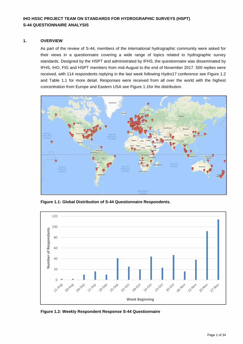
1. OVERVIEW
As part of the review of S-44, members of the international hydrographic community were asked for
their views in a questionnaire covering a wide range of topics related to hydrographic survey
standards. Designed by the HSPT and administrated by IFHS, the questionnaire was disseminated by
IFHS, IHO, FIG and HSPT members from mid-August to the end of November 2017. 500 replies were
received, with 114 respondents replying in the last week following Hydro17 conference see Figure 1.2
and Table 1.1 for more detail. Responses were received from all over the world with the highest
concentration from Europe and Eastern USA see Figure 1.1for the distribution.
Figure 1.1: Global Distribution of S-44 Questionnaire Respondents.
Figure 1.2: Weekly Respondent Response S-44 Questionnaire
0
20
40
60
80
100
120
Nu
mb
er
of
Re
spo
nd
ants
Week Beginning

IHO HSSC PROJECT TEAM ON STANDARDS FOR HYDROGRAPHIC SURVEYS (HSPT)
S-44 QUESTIONNAIRE ANALYSIS
Page 2 of 34
Table 1.1: Monthly Response Distribution S-44 Questionnaire Respondents
Month Number of Responses
August 3
September 75
October 141
November 281
IHO HSSC PROJECT TEAM ON STANDARDS FOR HYDROGRAPHIC SURVEYS (HSPT)
S-44 QUESTIONNAIRE ANALYSIS
Page 3 of 34
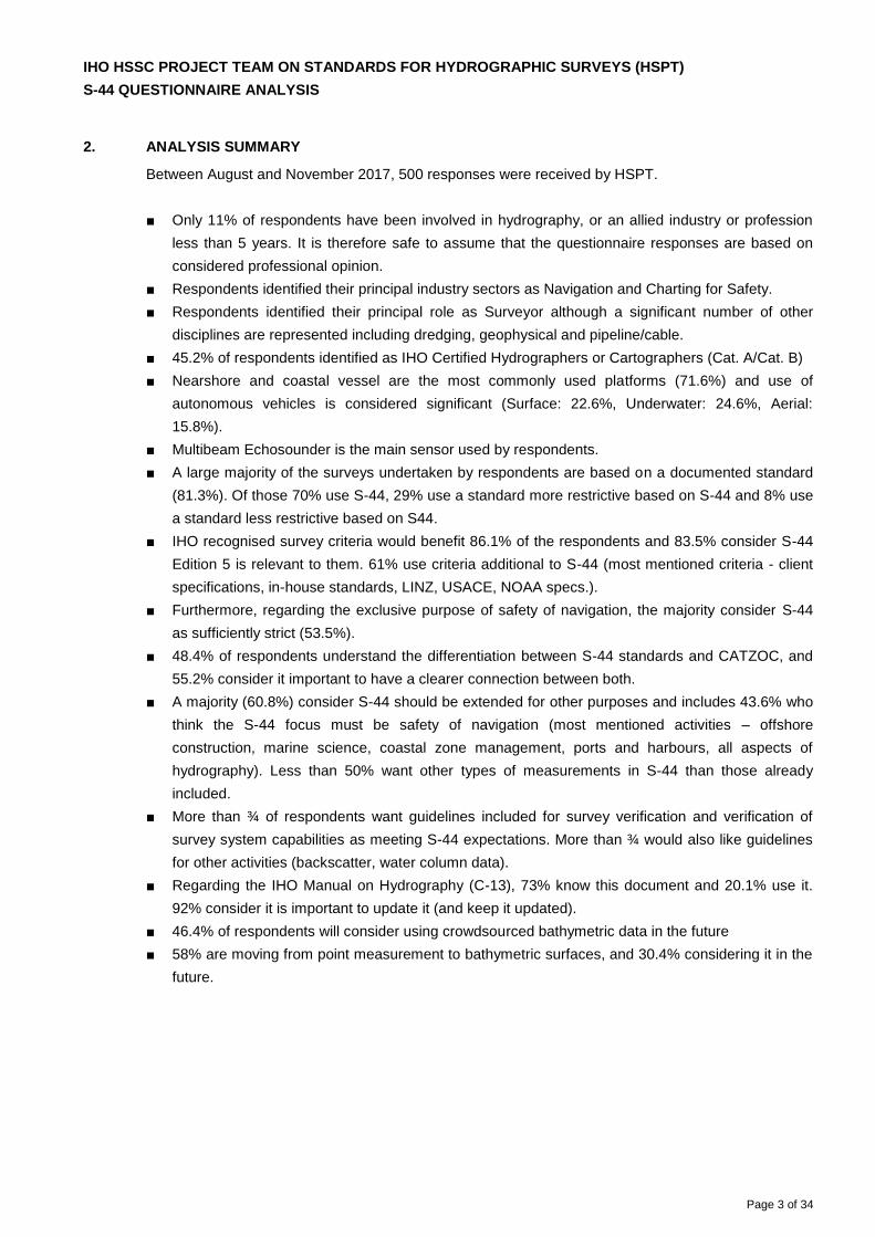
2. ANALYSIS SUMMARY
Between August and November 2017, 500 responses were received by HSPT.
■ Only 11% of respondents have been involved in hydrography, or an allied industry or profession
less than 5 years. It is therefore safe to assume that the questionnaire responses are based on
considered professional opinion.
■ Respondents identified their principal industry sectors as Navigation and Charting for Safety.
■ Respondents identified their principal role as Surveyor although a significant number of other
disciplines are represented including dredging, geophysical and pipeline/cable.
■ 45.2% of respondents identified as IHO Certified Hydrographers or Cartographers (Cat. A/Cat. B)
■ Nearshore and coastal vessel are the most commonly used platforms (71.6%) and use of
autonomous vehicles is considered significant (Surface: 22.6%, Underwater: 24.6%, Aerial:
15.8%).
■ Multibeam Echosounder is the main sensor used by respondents.
■ A large majority of the surveys undertaken by respondents are based on a documented standard
(81.3%). Of those 70% use S-44, 29% use a standard more restrictive based on S-44 and 8% use
a standard less restrictive based on S44.
■ IHO recognised survey criteria would benefit 86.1% of the respondents and 83.5% consider S-44
Edition 5 is relevant to them. 61% use criteria additional to S-44 (most mentioned criteria - client
specifications, in-house standards, LINZ, USACE, NOAA specs.).
■ Furthermore, regarding the exclusive purpose of safety of navigation, the majority consider S-44
as sufficiently strict (53.5%).
■ 48.4% of respondents understand the differentiation between S-44 standards and CATZOC, and
55.2% consider it important to have a clearer connection between both.
■ A majority (60.8%) consider S-44 should be extended for other purposes and includes 43.6% who
think the S-44 focus must be safety of navigation (most mentioned activities – offshore
construction, marine science, coastal zone management, ports and harbours, all aspects of
hydrography). Less than 50% want other types of measurements in S-44 than those already
included.
■ More than ¾ of respondents want guidelines included for survey verification and verification of
survey system capabilities as meeting S-44 expectations. More than ¾ would also like guidelines
for other activities (backscatter, water column data).
■ Regarding the IHO Manual on Hydrography (C-13), 73% know this document and 20.1% use it.
92% consider it is important to update it (and keep it updated).
■ 46.4% of respondents will consider using crowdsourced bathymetric data in the future
■ 58% are moving from point measurement to bathymetric surfaces, and 30.4% considering it in the
future.
IHO HSSC PROJECT TEAM ON STANDARDS FOR HYDROGRAPHIC SURVEYS (HSPT)
S-44 QUESTIONNAIRE ANALYSIS
Page 4 of 34
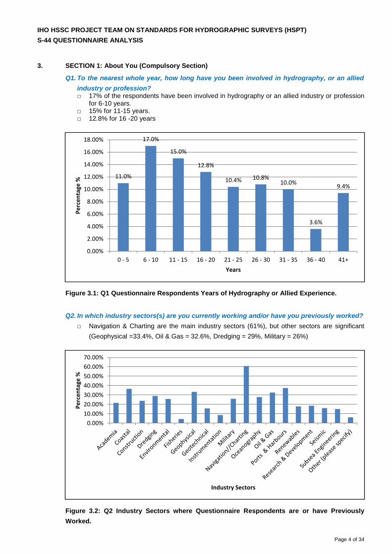
3. SECTION 1: About You (Compulsory Section)
Q1. To the nearest whole year, how long have you been involved in hydrography, or an allied
industry or profession? □ 17% of the respondents have been involved in hydrography or an allied industry or profession
for 6-10 years. □ 15% for 11-15 years. □ 12.8% for 16 -20 years
Figure 3.1: Q1 Questionnaire Respondents Years of Hydrography or Allied Experience.
Q2. In which industry sectors(s) are you currently working and/or have you previously worked?
□ Navigation & Charting are the main industry sectors (61%), but other sectors are significant
(Geophysical =33.4%, Oil & Gas = 32.6%, Dredging = 29%, Military = 26%)
Figure 3.2: Q2 Industry Sectors where Questionnaire Respondents are or have Previously
Worked.
11.0%
17.0%
15.0%
12.8%
10.4% 10.8%10.0%
3.6%
9.4%
0 - 5 6 - 10 11 - 15 16 - 20 21 - 25 26 - 30 31 - 35 36 - 40 41+
0.00%
2.00%
4.00%
6.00%
8.00%
10.00%
12.00%
14.00%
16.00%
18.00%
Years
Pe
rce
nta
ge %
0.00%
10.00%
20.00%
30.00%
40.00%
50.00%
60.00%
70.00%
Industry Sectors
Pe
rce
nta
ge %
IHO HSSC PROJECT TEAM ON STANDARDS FOR HYDROGRAPHIC SURVEYS (HSPT)
S-44 QUESTIONNAIRE ANALYSIS
Page 5 of 34
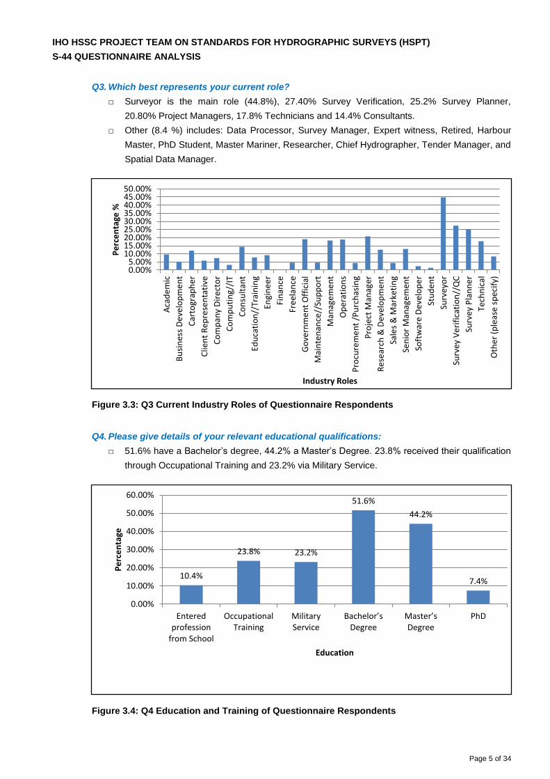
Q3. Which best represents your current role?
□ Surveyor is the main role (44.8%), 27.40% Survey Verification, 25.2% Survey Planner,
20.80% Project Managers, 17.8% Technicians and 14.4% Consultants.
□ Other (8.4 %) includes: Data Processor, Survey Manager, Expert witness, Retired, Harbour
Master, PhD Student, Master Mariner, Researcher, Chief Hydrographer, Tender Manager, and
Spatial Data Manager.
Figure 3.3: Q3 Current Industry Roles of Questionnaire Respondents
Q4. Please give details of your relevant educational qualifications:
□ 51.6% have a Bachelor’s degree, 44.2% a Master’s Degree. 23.8% received their qualification
through Occupational Training and 23.2% via Military Service.
Figure 3.4: Q4 Education and Training of Questionnaire Respondents
Aca
de
mic
Bu
sin
ess
De
velo
pm
en
t
Car
togr
aph
er
Clie
nt
Rep
rese
nta
tive
Co
mp
any
Dir
ect
or
Co
mp
uti
ng/
/IT
Co
nsu
ltan
t
Edu
cati
on
//Tr
ain
ing
Engi
nee
r
Fin
ance
Fre
elan
ce
Go
vern
me
nt
Off
icia
l
Mai
nte
nan
ce//
Sup
po
rt
Man
age
me
nt
Op
erat
ion
s
Pro
cure
me
nt
/Pu
rch
asin
g
Pro
ject
Man
ager
Re
sear
ch &
Dev
elo
pm
ent
Sale
s &
Mar
keti
ng
Sen
ior
Man
agem
ent
Soft
war
e D
evel
op
er
Stu
den
t
Surv
eyo
r
Surv
ey V
eri
fica
tio
n//
QC
Surv
ey P
lan
ne
r
Tech
nic
al
Oth
er (
ple
ase
sp
ecif
y)
0.00%5.00%
10.00%15.00%20.00%25.00%30.00%35.00%40.00%45.00%50.00%
Industry Roles
Pe
rce
nta
ge %
10.4%
23.8% 23.2%
51.6%
44.2%
7.4%
Enteredprofession
from School
OccupationalTraining
MilitaryService
Bachelor’s Degree
Master’s Degree
PhD
0.00%
10.00%
20.00%
30.00%
40.00%
50.00%
60.00%
Education
Pe
rce
nta
ge
IHO HSSC PROJECT TEAM ON STANDARDS FOR HYDROGRAPHIC SURVEYS (HSPT)
S-44 QUESTIONNAIRE ANALYSIS
Page 6 of 34
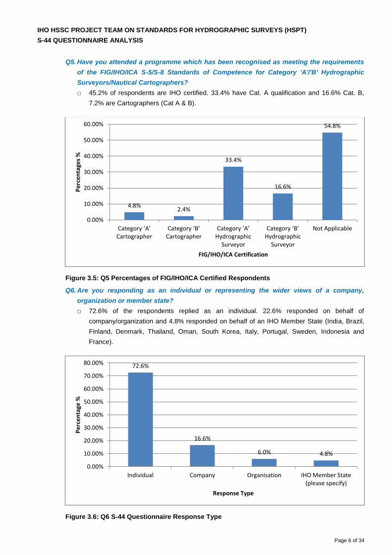
Q5. Have you attended a programme which has been recognised as meeting the requirements
of the FIG/IHO/ICA S-5/S-8 Standards of Competence for Category 'A'/'B' Hydrographic
Surveyors/Nautical Cartographers?
□ 45.2% of respondents are IHO certified. 33.4% have Cat. A qualification and 16.6% Cat. B,
7.2% are Cartographers (Cat A & B).
Figure 3.5: Q5 Percentages of FIG/IHO/ICA Certified Respondents
Q6. Are you responding as an individual or representing the wider views of a company,
organization or member state?
□ 72.6% of the respondents replied as an individual. 22.6% responded on behalf of
company/organization and 4.8% responded on behalf of an IHO Member State (India, Brazil,
Finland, Denmark, Thailand, Oman, South Korea, Italy, Portugal, Sweden, Indonesia and
France).
Figure 3.6: Q6 S-44 Questionnaire Response Type
4.8%2.4%
33.4%
16.6%
54.8%
Category ‘A’ Cartographer
Category ‘B’ Cartographer
Category ‘A’ Hydrographic
Surveyor
Category ‘B’ Hydrographic
Surveyor
Not Applicable
0.00%
10.00%
20.00%
30.00%
40.00%
50.00%
60.00%
FIG/IHO/ICA Certification
Pe
rce
nta
ges
%
72.6%
16.6%
6.0% 4.8%
Individual Company Organisation IHO Member State(please specify)
0.00%
10.00%
20.00%
30.00%
40.00%
50.00%
60.00%
70.00%
80.00%
Response Type
Pe
rce
nta
ge %
IHO HSSC PROJECT TEAM ON STANDARDS FOR HYDROGRAPHIC SURVEYS (HSPT)
S-44 QUESTIONAIRE ANALYSIS
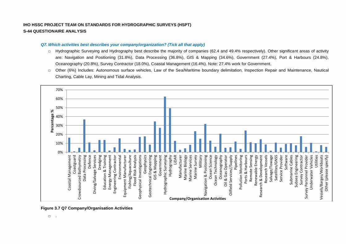
Q7. Which activities best describes your company/organization? (Tick all that apply)
□ Hydrographic Surveying and Hydrography best describe the majority of companies (62.4 and 49.4% respectively). Other significant areas of activity
are: Navigation and Positioning (31.8%), Data Processing (36.8%), GIS & Mapping (34.6%), Government (27.4%), Port & Harbours (24.8%),
Oceanography (20.8%), Survey Contractor (18.0%), Coastal Management (16.4%). Note: 27.4% work for Government.
□ Other (6%) Includes: Autonomous surface vehicles, Law of the Sea/Maritime boundary delimitation, Inspection Repair and Maintenance, Nautical
Charting, Cable Lay, Mining and Tidal Analysis.
Figure 3.7 Q7 Company/Organisation Activities
□ .
Co
asta
l Man
agem
ent
Co
astg
uar
dC
row
dso
urc
ed
Bat
hym
etry
Dat
a P
roce
ssin
gD
efe
nce
Div
ing/
Salv
age
Ser
vice
sD
red
gin
gEd
uca
tio
n &
Tra
inin
gEn
ergy
Man
agem
ent
Engi
nee
rin
g C
on
trac
tor
Envi
ron
men
tal
Equ
ipm
ent
Man
ufa
ctu
rer
Fish
ing/
Aq
uac
ult
ure
Flo
od
Ris
k A
nal
ysis
Geo
ph
ysic
al In
vest
igat
ion
sG
eop
hys
ics
Geo
tech
nic
al E
ngi
ne
erin
gG
IS &
Map
pin
gG
ove
rnm
en
tH
ydro
grap
hic
Su
rve
yin
gH
ydro
grap
hy
LiD
AR
Man
ufa
ctu
rer
Mar
ine
Bio
logy
Mar
ine
Ser
vice
sM
arin
e S
urv
ey
Mili
tary
Nav
igat
ion
& P
osi
tio
nin
gO
cean
Sci
en
ceO
cean
Te
chn
olo
gyO
cean
ogr
aph
yO
il &
Gas
Op
erat
or
Oilf
ield
Se
rvic
es//
Sup
ply
Pip
elin
es
Po
lluti
on
Mo
nit
ori
ng
Po
rts
& H
arb
ou
rsR
em
ote
Sen
sin
gR
en
ewab
le E
ne
rgy
Re
sear
ch &
Dev
elo
pm
ent
Re
sear
ch V
esse
lsSa
lvag
e/T
ow
age
Sate
llite
s/G
NSS
Serv
ice
Pro
vid
erSo
ftw
are
Sub
mar
ine
Cab
les
Sub
sea
Engi
ne
erin
gSu
rvey
Co
ntr
acto
rSu
rvey
Per
son
ne
l Pro
vid
er
Un
de
rwat
er V
ehic
les
Uti
litie
sV
ess
els/
Bar
ges/
Wo
rkb
oat
sO
ther
(p
leas
e s
pec
ify)
0%
10%
20%
30%
40%
50%
60%
70%
Company/Organisation Activities
Pe
rce
nta
ge %
IHO HSSC PROJECT TEAM ON STANDARDS FOR HYDROGRAPHIC SURVEYS (HSPT)
S-44 QUESTIONAIRE ANALYSIS
8
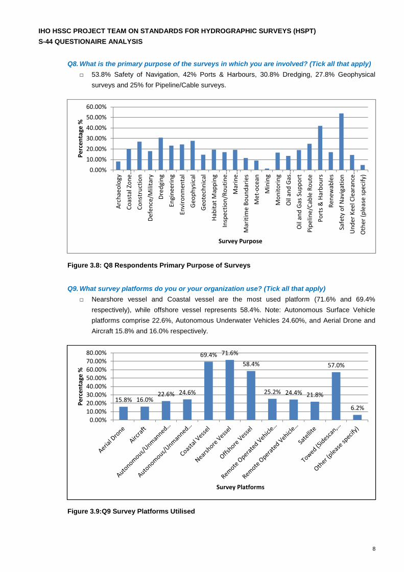
Q8. What is the primary purpose of the surveys in which you are involved? (Tick all that apply)
□ 53.8% Safety of Navigation, 42% Ports & Harbours, 30.8% Dredging, 27.8% Geophysical
surveys and 25% for Pipeline/Cable surveys.
Figure 3.8: Q8 Respondents Primary Purpose of Surveys
Q9. What survey platforms do you or your organization use? (Tick all that apply)
□ Nearshore vessel and Coastal vessel are the most used platform (71.6% and 69.4%
respectively), while offshore vessel represents 58.4%. Note: Autonomous Surface Vehicle
platforms comprise 22.6%, Autonomous Underwater Vehicles 24.60%, and Aerial Drone and
Aircraft 15.8% and 16.0% respectively.
Figure 3.9:Q9 Survey Platforms Utilised
Arc
hae
olo
gy
Co
asta
l Zo
ne
…
Co
nst
ruct
ion
De
fen
ce/M
ilita
ry
Dre
dgi
ng
Engi
nee
rin
g
Envi
ron
men
tal
Geo
ph
ysic
al
Geo
tech
nic
al
Hab
itat
Map
pin
g
Insp
ect
ion
/Ro
uti
ne…
Mar
ine
…
Mar
itim
e B
ou
nd
arie
s
Me
t-o
cean
Min
ing
Mo
nit
ori
ng
Oil
and
Gas
…
Oil
and
Gas
Su
pp
ort
Pip
elin
e/C
able
Ro
ute
Po
rts
& H
arb
ou
rs
Re
new
able
s
Safe
ty o
f N
avig
atio
n
Un
de
r K
eel C
lear
ance
…
Oth
er (
ple
ase
sp
ecif
y)
0.00%
10.00%
20.00%
30.00%
40.00%
50.00%
60.00%
Survey Purpose
Pe
rce
nta
ge %
15.8% 16.0%22.6% 24.6%
69.4% 71.6%
58.4%
25.2% 24.4% 21.8%
57.0%
6.2%
0.00%10.00%20.00%30.00%40.00%50.00%60.00%70.00%80.00%
Survey Platforms
Pe
rce
nta
ge %

IHO HSSC PROJECT TEAM ON STANDARDS FOR HYDROGRAPHIC SURVEYS (HSPT)
S-44 QUESTIONAIRE ANALYSIS
9
Q10. What survey sensors do you or your organisation use? (Tick all that apply)
□ Multibeam Echosounder is the main sensor used (88%). Other Hydrographic or Object
Detection systems are: Sidescan Sonar (79.4%), Singlebeam Echosounder (76.8%), Satellite
(39.0%), Interferometric Systems (32.4%), Laser Scanner (31.8%), LIDAR (29.2%). Note: Tide
gauges are used by 72.0% of the respondents and Speed of Sound Profiler by 72.8%
(meaning that 37.2% don’t use sound velocity profiles?). Sub Bottom Profilers are used by
54.2% of the respondents.
Figure 3.10 Q10 Survey Sensors Utilised.
54.6%
32.4% 31.8% 29.2%
45.4%
88.0%
39.0%
79.4% 76.8% 72.8%
54.2%
11.6%
72.0%
7.4%
0.00%10.00%20.00%30.00%40.00%50.00%60.00%70.00%80.00%90.00%
100.00%
Survey Sensors
Pe
rce
nta
ge %
IHO HSSC PROJECT TEAM ON STANDARDS FOR HYDROGRAPHIC SURVEYS (HSPT)
S-44 QUESTIONAIRE ANALYSIS
10
4. SECTION 2: Use of Standard
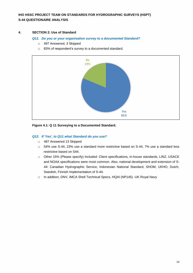
Q11. Do you or your organisation survey to a documented Standard?
□ 497 Answered, 3 Skipped
□ 83% of respondent’s survey to a documented standard.
Figure 4.1: Q 11 Surveying to a Documented Standard.
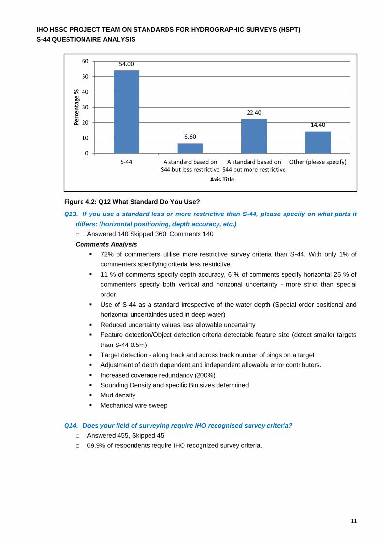
Q12. If 'Yes', to Q11 what Standard do you use?
□ 487 Answered 13 Skipped
□ 54% use S-44, 23% use a standard more restrictive based on S-44, 7% use a standard less
restrictive based on S44.
□ Other 15% (Please specify) Included: Client specifications, in-house standards, LINZ, USACE
and NOAA specifications were most common. Also, national development and extension of S-
44: Canadian Hydrographic Service, Indonesian National Standard, SHOM, UKHO, Dutch,
Swedish, Finnish Implementation of S-44.
□ In addition, DNV, IMCA Shell Technical Specs, HQAI (NP145) -UK Royal Navy
Yes81%
No19%
IHO HSSC PROJECT TEAM ON STANDARDS FOR HYDROGRAPHIC SURVEYS (HSPT)
S-44 QUESTIONAIRE ANALYSIS
11
Figure 4.2: Q12 What Standard Do You Use?
Q13. If you use a standard less or more restrictive than S-44, please specify on what parts it
differs: (horizontal positioning, depth accuracy, etc.)
□ Answered 140 Skipped 360, Comments 140
Comments Analysis
72% of commenters utilise more restrictive survey criteria than S-44. With only 1% of
commenters specifying criteria less restrictive
11 % of comments specify depth accuracy, 6 % of comments specify horizontal 25 % of
commenters specify both vertical and horizonal uncertainty - more strict than special
order.
Use of S-44 as a standard irrespective of the water depth (Special order positional and
horizontal uncertainties used in deep water)
Reduced uncertainty values less allowable uncertainty
Feature detection/Object detection criteria detectable feature size (detect smaller targets
than S-44 0.5m)
Target detection - along track and across track number of pings on a target
Adjustment of depth dependent and independent allowable error contributors.
Increased coverage redundancy (200%)
Sounding Density and specific Bin sizes determined
Mud density
Mechanical wire sweep
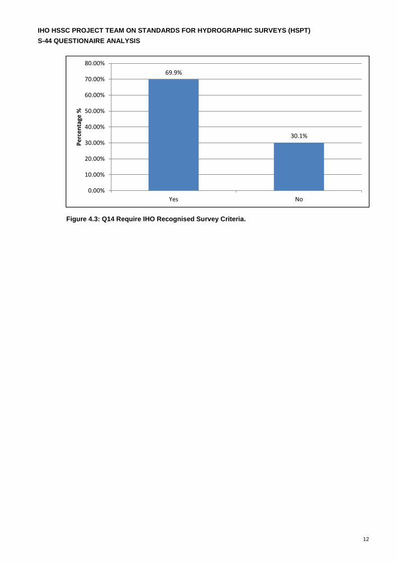
Q14. Does your field of surveying require IHO recognised survey criteria?
□ Answered 455, Skipped 45
□ 69.9% of respondents require IHO recognized survey criteria.
54.00
6.60
22.40
14.40
S-44 A standard based onS44 but less restrictive
A standard based onS44 but more restrictive
Other (please specify)
0
10
20
30
40
50
60
Axis Title
Pe
rce
nta
ge %
IHO HSSC PROJECT TEAM ON STANDARDS FOR HYDROGRAPHIC SURVEYS (HSPT)
S-44 QUESTIONAIRE ANALYSIS
12
Figure 4.3: Q14 Require IHO Recognised Survey Criteria.
69.9%
30.1%
Yes No
0.00%
10.00%
20.00%
30.00%
40.00%
50.00%
60.00%
70.00%
80.00%
Pe
rce
nta
ge %
IHO HSSC PROJECT TEAM ON STANDARDS FOR HYDROGRAPHIC SURVEYS (HSPT)
S-44 QUESTIONAIRE ANALYSIS
13
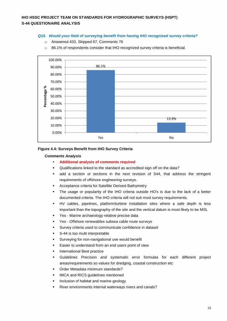
Q15. Would your field of surveying benefit from having IHO recognised survey criteria?
□ Answered 433, Skipped 67, Comments 76
□ 86.1% of respondents consider that IHO recognized survey criteria is beneficial.
Figure 4.4: Surveys Benefit from IHO Survey Criteria
Comments Analysis
Additional analysis of comments required
Qualifications linked to the standard as accredited sign off on the data?
add a section or sections in the next revision of S44, that address the stringent
requirements of offshore engineering surveys.
Acceptance criteria for Satellite Derived Bathymetry
The usage or popularity of the IHO criteria outside HO's is due to the lack of a better
documented criteria. The IHO criteria will not suit most survey requirements.
HV cables, pipelines, platform/turbine installation sites where a safe depth is less
important than the topography of the site and the vertical datum is most likely to be MSL
Yes - Marine archaeology relative precise data
Yes - Offshore renewables subsea cable route surveys
Survey criteria used to communicate confidence in dataset
S-44 is too multi interpretable
Surveying for non-navigational use would benefit
Easier to understand from an end users point of view
International Best practice
Guidelines Precision and systematic error formulas for each different project
areas/requirements so values for dredging, coastal construction etc
Order Metadata minimum standards?
IMCA and RICS guidelines mentioned
Inclusion of habitat and marine geology
River environments internal waterways rivers and canals?
86.1%
13.9%
Yes No
0.00%
10.00%
20.00%
30.00%
40.00%
50.00%
60.00%
70.00%
80.00%
90.00%
100.00%
Pe
rce
nta
ge %
IHO HSSC PROJECT TEAM ON STANDARDS FOR HYDROGRAPHIC SURVEYS (HSPT)
S-44 QUESTIONAIRE ANALYSIS
14
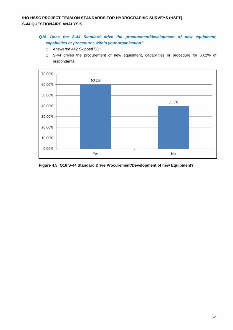
Q16. Does the S-44 Standard drive the procurement/development of new equipment,
capabilities or procedures within your organisation?
□ Answered 442 Skipped 58;
□ S-44 drives the procurement of new equipment, capabilities or procedure for 60.2% of
respondents.
Figure 4.5: Q16 S-44 Standard Drive Procurement/Development of new Equipment?
60.2%
39.8%
Yes No
0.00%
10.00%
20.00%
30.00%
40.00%
50.00%
60.00%
70.00%
IHO HSSC PROJECT TEAM ON STANDARDS FOR HYDROGRAPHIC SURVEYS (HSPT)
S-44 QUESTIONAIRE ANALYSIS
15
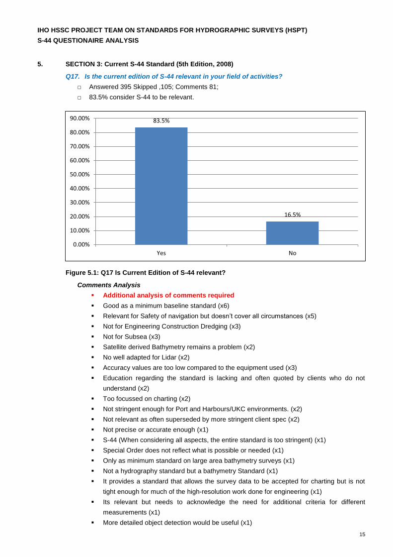
5. SECTION 3: Current S-44 Standard (5th Edition, 2008)
Q17. Is the current edition of S-44 relevant in your field of activities?
□ Answered 395 Skipped ,105; Comments 81;
□ 83.5% consider S-44 to be relevant.
Figure 5.1: Q17 Is Current Edition of S-44 relevant?
Comments Analysis
Additional analysis of comments required
Good as a minimum baseline standard (x6)
Relevant for Safety of navigation but doesn’t cover all circumstances (x5)
Not for Engineering Construction Dredging (x3)
Not for Subsea (x3)
Satellite derived Bathymetry remains a problem (x2)
No well adapted for Lidar (x2)
Accuracy values are too low compared to the equipment used (x3)
Education regarding the standard is lacking and often quoted by clients who do not
understand (x2)
Too focussed on charting (x2)
Not stringent enough for Port and Harbours/UKC environments. (x2)
Not relevant as often superseded by more stringent client spec (x2)
Not precise or accurate enough (x1)
S-44 (When considering all aspects, the entire standard is too stringent) (x1)
Special Order does not reflect what is possible or needed (x1)
Only as minimum standard on large area bathymetry surveys (x1)
Not a hydrography standard but a bathymetry Standard (x1)
It provides a standard that allows the survey data to be accepted for charting but is not
tight enough for much of the high-resolution work done for engineering (x1)
Its relevant but needs to acknowledge the need for additional criteria for different
measurements (x1)
More detailed object detection would be useful (x1)
83.5%
16.5%
Yes No
0.00%
10.00%
20.00%
30.00%
40.00%
50.00%
60.00%
70.00%
80.00%
90.00%
IHO HSSC PROJECT TEAM ON STANDARDS FOR HYDROGRAPHIC SURVEYS (HSPT)
S-44 QUESTIONAIRE ANALYSIS
16
Greater detail for Interferometric sensors (x1)
It is relevant but needs to be modified to keep pace with current equipment technology
(x1).
Outdated and well over due for revision (x1)
Relevant to multibeam surveys, not to single beam surveys used in soft bottom areas (x1)
Q18. Does your Company, Organisation or State include additional criteria above and beyond
the IHO S-44 Standard when commissioning hydrographic survey activity?
□ Answered 381 Skipped 119, Comments 93
□ More than 61% of respondents use criteria additional to S-44.
Figure 5.2: Additional Criteria above and beyond IHO S-44
Comments Analysis
Additional analysis of comments required
Feature/object Detection (x5)
Sounding Density Minimum Points/soundings per grid cell/ gridding (x5)
Linz Standard (x3)
Stricter vertical and horizontal tolerances (x3)
More stringent accuracies x2
Sign off by specified level of qualification (Level 1 certified professional through the
Australasian Hydrographic Surveyors Certification Panel for example) (x2)
Coverage (x2)
Not stringent enough for subsea lidar/laser technologies (x1)
Feature size rules (CUBE and cartographic horizontal uncertainty in terms of Cube Node
spacing) (x1)
Depth precision in line with Under Keel Clearance requirements (x1)
Higher than 95 % confidence level (x1)
More stringent TVU for deeper water (x1)
61.4%
38.6%
Yes No
0.00%
10.00%
20.00%
30.00%
40.00%
50.00%
60.00%
70.00%

IHO HSSC PROJECT TEAM ON STANDARDS FOR HYDROGRAPHIC SURVEYS (HSPT)
S-44 QUESTIONAIRE ANALYSIS
17
Overlap (x1)
Minimum Equipment Accuracy/Uncertainty (x1)
S-44 ‘Exclusive Order’ (Swedish, Finnish and Canadian adaptation) (x1)
Additional Measurements/criteria (x1)
More |Stringent Quality Control (Method for meeting the standard) (x1)
Additional criteria added for engineering construction surveys (x1)
Route surveys uncertainty allowances mad tighter x1 (x1)
Detailed error budget must be provided (x1)
Tighter tolerance for Deeper water surveys (x1)
An order 3 defined for Satellite Derived Bathymetry? (x1)
FSIS44 (x1)
Backscatter x(x1)
Water Column (x1)
Positioning (x1)
ERS Grids (x1)
Designated soundings (x1)
Resolution Guidelines (x1)
Tighter Horizontal Positioning (x1)
NOAA HSSD (x1)
Value for money (x1)
Frequency of areas resurvey defined (x1)
Full seafloor search is mandatory with MBES 100% overlap (x1)
TVU limits are linked to sediment mobility and depth of burial of cables (x1)
SHOM Documentation used (x1)
IMCA Guidelines used (x1)
NL norma a and b (x1)
Scanning of the shore and further (x1)
Maximum Swath Widths and Frequency to be used. (x1)
Overlap 2005 plus Cross/check lines (x1)
Recommended equipment (x1)
IHO HSSC PROJECT TEAM ON STANDARDS FOR HYDROGRAPHIC SURVEYS (HSPT)
S-44 QUESTIONAIRE ANALYSIS
18
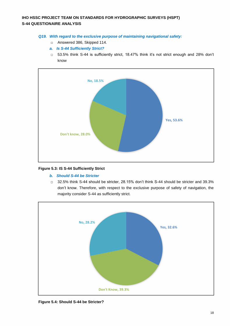
Q19. With regard to the exclusive purpose of maintaining navigational safety:
□ Answered 386, Skipped 114.
a. Is S-44 Sufficiently Strict?
□ 53.5% think S-44 is sufficiently strict, 18.47% think it’s not strict enough and 28% don’t
know
Figure 5.3: IS S-44 Sufficiently Strict
b. Should S-44 be Stricter
□ 32.5% think S-44 should be stricter, 28.15% don’t think S-44 should be stricter and 39.3%
don’t know. Therefore, with respect to the exclusive purpose of safety of navigation, the
majority consider S-44 as sufficiently strict.
Figure 5.4: Should S-44 be Stricter?
Yes, 53.6%
Don't know, 28.0%
No, 18.5%
Yes, 32.6%
Don't Know, 39.3%
No, 28.2%
IHO HSSC PROJECT TEAM ON STANDARDS FOR HYDROGRAPHIC SURVEYS (HSPT)
S-44 QUESTIONAIRE ANALYSIS
19
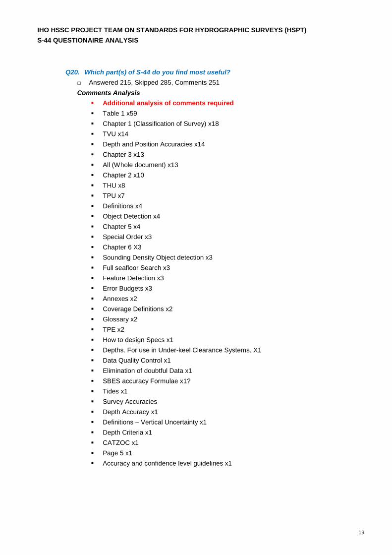
Q20. Which part(s) of S-44 do you find most useful?
□ Answered 215, Skipped 285, Comments 251
Comments Analysis
Additional analysis of comments required
Table 1 x59
Chapter 1 (Classification of Survey) x18
TVU x14
Depth and Position Accuracies x14
Chapter 3 x13
All (Whole document) x13
Chapter 2 x10
THU x8
TPU x7
Definitions x4
Object Detection x4
Chapter 5 x4
Special Order x3
Chapter 6 X3
Sounding Density Object detection x3
Full seafloor Search x3
Feature Detection x3
Error Budgets x3
Annexes x2
Coverage Definitions x2
Glossary x2
TPE x2
How to design Specs x1
Depths. For use in Under-keel Clearance Systems. X1
Data Quality Control x1
Elimination of doubtful Data x1
SBES accuracy Formulae x1?
Tides x1
Survey Accuracies
Depth Accuracy x1
Definitions – Vertical Uncertainty x1
Depth Criteria x1
CATZOC x1
Page 5 x1
Accuracy and confidence level guidelines x1
IHO HSSC PROJECT TEAM ON STANDARDS FOR HYDROGRAPHIC SURVEYS (HSPT)
S-44 QUESTIONAIRE ANALYSIS
20
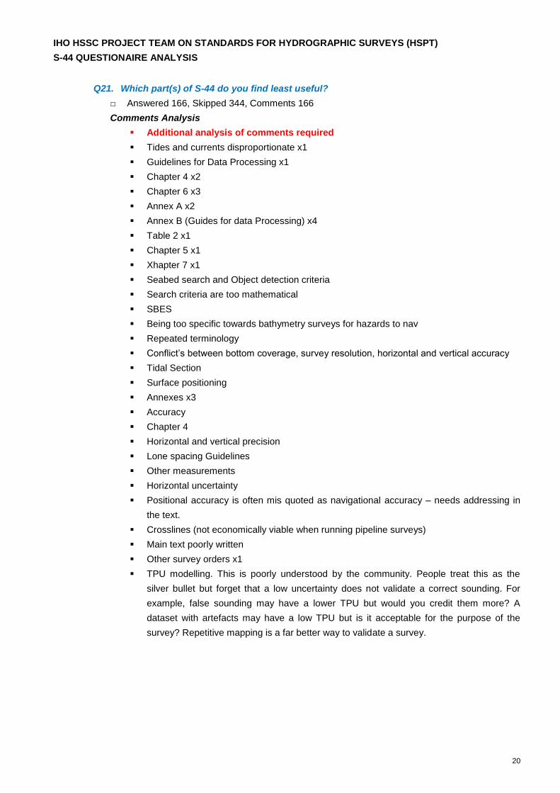
Q21. Which part(s) of S-44 do you find least useful?
□ Answered 166, Skipped 344, Comments 166
Comments Analysis
Additional analysis of comments required
Tides and currents disproportionate x1
Guidelines for Data Processing x1
Chapter 4 x2
Chapter 6 x3
Annex A x2
Annex B (Guides for data Processing) x4
Table 2 x1
Chapter 5 x1
Xhapter 7 x1
Seabed search and Object detection criteria
Search criteria are too mathematical
SBES
Being too specific towards bathymetry surveys for hazards to nav
Repeated terminology
Conflict’s between bottom coverage, survey resolution, horizontal and vertical accuracy
Tidal Section
Surface positioning
Annexes x3
Accuracy
Chapter 4
Horizontal and vertical precision
Lone spacing Guidelines
Other measurements
Horizontal uncertainty
Positional accuracy is often mis quoted as navigational accuracy – needs addressing in
the text.
Crosslines (not economically viable when running pipeline surveys)
Main text poorly written
Other survey orders x1
TPU modelling. This is poorly understood by the community. People treat this as the
silver bullet but forget that a low uncertainty does not validate a correct sounding. For
example, false sounding may have a lower TPU but would you credit them more? A
dataset with artefacts may have a low TPU but is it acceptable for the purpose of the
survey? Repetitive mapping is a far better way to validate a survey.
IHO HSSC PROJECT TEAM ON STANDARDS FOR HYDROGRAPHIC SURVEYS (HSPT)
S-44 QUESTIONAIRE ANALYSIS
21
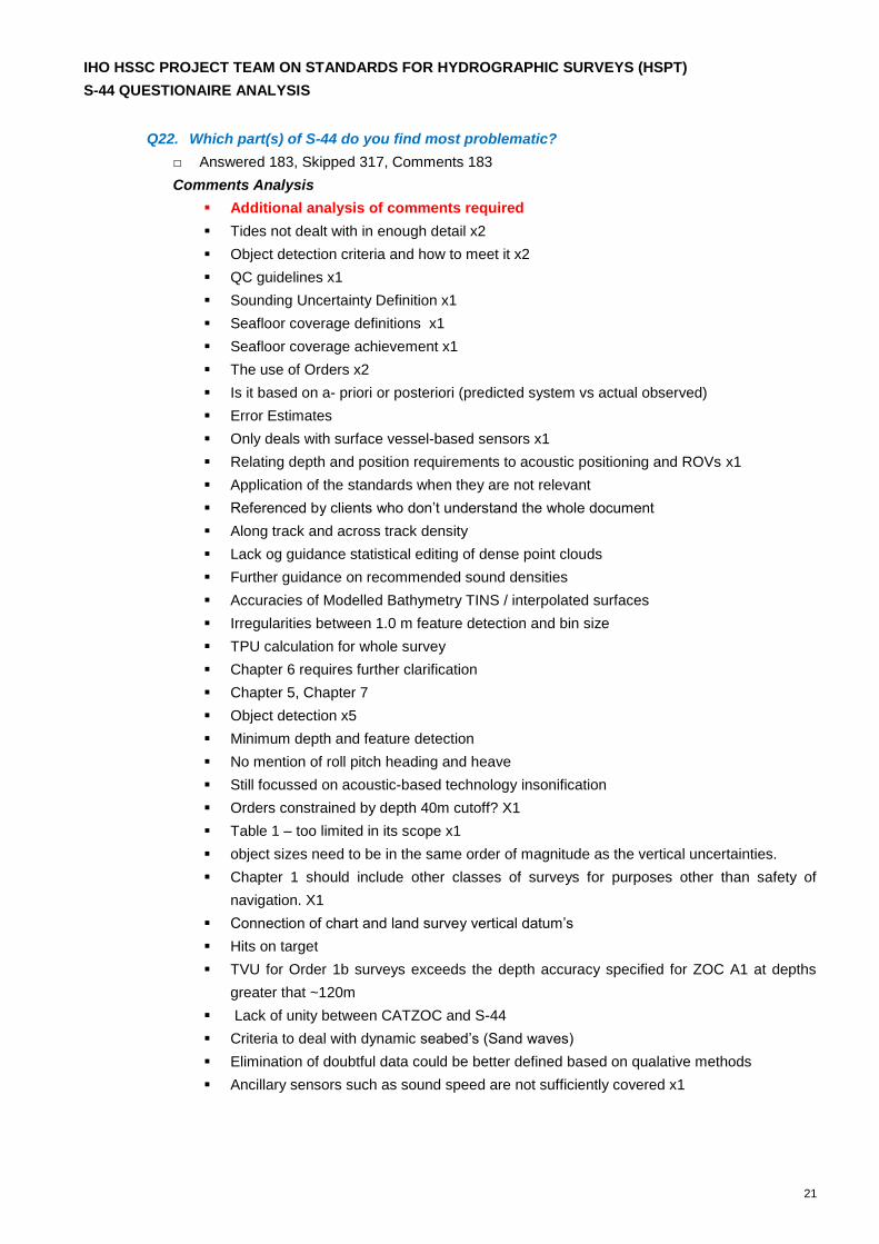
Q22. Which part(s) of S-44 do you find most problematic?
□ Answered 183, Skipped 317, Comments 183
Comments Analysis
Additional analysis of comments required
Tides not dealt with in enough detail x2
Object detection criteria and how to meet it x2
QC guidelines x1
Sounding Uncertainty Definition x1
Seafloor coverage definitions x1
Seafloor coverage achievement x1
The use of Orders x2
Is it based on a- priori or posteriori (predicted system vs actual observed)
Error Estimates
Only deals with surface vessel-based sensors x1
Relating depth and position requirements to acoustic positioning and ROVs x1
Application of the standards when they are not relevant
Referenced by clients who don’t understand the whole document
Along track and across track density
Lack og guidance statistical editing of dense point clouds
Further guidance on recommended sound densities
Accuracies of Modelled Bathymetry TINS / interpolated surfaces
Irregularities between 1.0 m feature detection and bin size
TPU calculation for whole survey
Chapter 6 requires further clarification
Chapter 5, Chapter 7
Object detection x5
Minimum depth and feature detection
No mention of roll pitch heading and heave
Still focussed on acoustic-based technology insonification
Orders constrained by depth 40m cutoff? X1
Table 1 – too limited in its scope x1
object sizes need to be in the same order of magnitude as the vertical uncertainties.
Chapter 1 should include other classes of surveys for purposes other than safety of
navigation. X1
Connection of chart and land survey vertical datum’s
Hits on target
TVU for Order 1b surveys exceeds the depth accuracy specified for ZOC A1 at depths
greater that ~120m
Lack of unity between CATZOC and S-44
Criteria to deal with dynamic seabed’s (Sand waves)
Elimination of doubtful data could be better defined based on qualative methods
Ancillary sensors such as sound speed are not sufficiently covered x1
IHO HSSC PROJECT TEAM ON STANDARDS FOR HYDROGRAPHIC SURVEYS (HSPT)
S-44 QUESTIONAIRE ANALYSIS
22
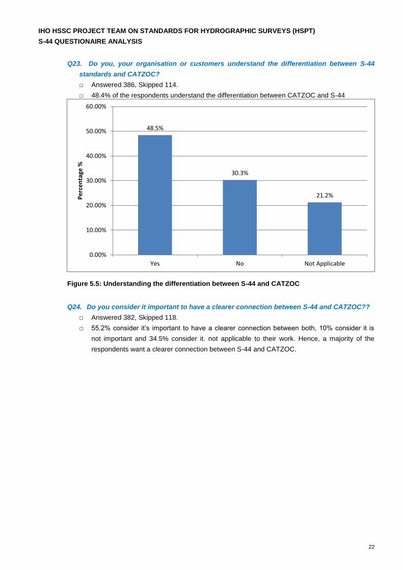
Q23. Do you, your organisation or customers understand the differentiation between S-44
standards and CATZOC?
□ Answered 386, Skipped 114.
□ 48.4% of the respondents understand the differentiation between CATZOC and S-44
Figure 5.5: Understanding the differentiation between S-44 and CATZOC
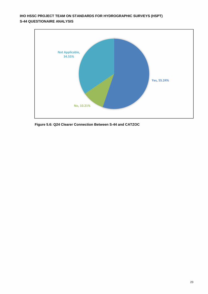
Q24. Do you consider it important to have a clearer connection between S-44 and CATZOC??
□ Answered 382, Skipped 118.
□ 55.2% consider it’s important to have a clearer connection between both, 10% consider it is
not important and 34.5% consider it. not applicable to their work. Hence, a majority of the
respondents want a clearer connection between S-44 and CATZOC.
48.5%
30.3%
21.2%
Yes No Not Applicable
0.00%
10.00%
20.00%
30.00%
40.00%
50.00%
60.00%
Pe
rce
nta
ge %
IHO HSSC PROJECT TEAM ON STANDARDS FOR HYDROGRAPHIC SURVEYS (HSPT)
S-44 QUESTIONAIRE ANALYSIS
23
Figure 5.6: Q24 Clearer Connection Between S-44 and CATZOC
Yes, 55.24%
No, 10.21%
Not Applicable, 34.55%
IHO HSSC PROJECT TEAM ON STANDARDS FOR HYDROGRAPHIC SURVEYS (HSPT)
S-44 QUESTIONAIRE ANALYSIS
24
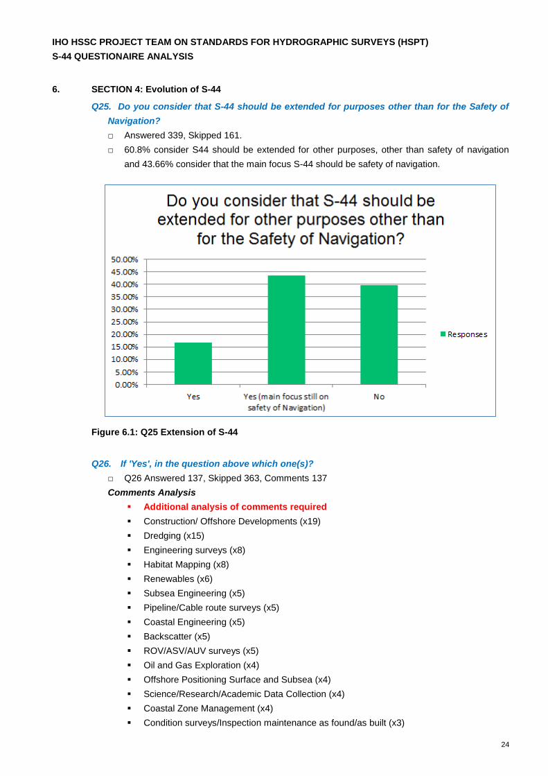
6. SECTION 4: Evolution of S-44
Q25. Do you consider that S-44 should be extended for purposes other than for the Safety of
Navigation?
□ Answered 339, Skipped 161.
□ 60.8% consider S44 should be extended for other purposes, other than safety of navigation
and 43.66% consider that the main focus S-44 should be safety of navigation.
Figure 6.1: Q25 Extension of S-44
Q26. If 'Yes', in the question above which one(s)?
□ Q26 Answered 137, Skipped 363, Comments 137
Comments Analysis
Additional analysis of comments required
Construction/ Offshore Developments (x19)
Dredging (x15)
Engineering surveys (x8)
Habitat Mapping (x8)
Renewables (x6)
Subsea Engineering (x5)
Pipeline/Cable route surveys (x5)
Coastal Engineering (x5)
Backscatter (x5)
ROV/ASV/AUV surveys (x5)
Oil and Gas Exploration (x4)
Offshore Positioning Surface and Subsea (x4)
Science/Research/Academic Data Collection (x4)
Coastal Zone Management (x4)
Condition surveys/Inspection maintenance as found/as built (x3)
IHO HSSC PROJECT TEAM ON STANDARDS FOR HYDROGRAPHIC SURVEYS (HSPT)
S-44 QUESTIONAIRE ANALYSIS
25
Under Keel Clearance Surveys (x3)
Disaster Management (x3)
Satellite Derived Bathymetry (x3)
Crowd Sourced Bathymetry (x3)
Tides – Tidal streams height prediction and currents (x2)
Fisheries and Aquaculture (Benthic and Pelagic) (x2)
Seabed Classification /characteristics (x2)
Environmental Monitoring (x2)
Met-Ocean Observations (x2)
Reconnaissance/Rapid environmental Assessment (x2)
UNCLOS (x2)
Water Column
Gravity
Geotechnical
Geophysical Site Survey
Marine Geology
Mining
Routine Resurvey Requirements
Seabed Evolution - Survey Data how long is it valid
Modern techniques for removal of doubtful data
Searching for recently lost Aircraft / ships
Subsea Acoustic Positioning system uncertainty ROV/AUV
GNSS Derived Tides
Better Doubtful Data definitions
Non- hazard search criteria
Relative positioning such as Archelogy
Unexploded Ordinance
High Accuracy surveys outside of navigation areas.
Sub bottom Profilers
Sidescan Sonars
Competency Hydrography career paths
IMCA
Q27. For which purpose(s)?
□ Q27 Answered 115, Skipped 385, Comments 115
□ The comment responses are linked to Q26, and the responses are far too spread to analyse in
this context and may require additional analysis.
IHO HSSC PROJECT TEAM ON STANDARDS FOR HYDROGRAPHIC SURVEYS (HSPT)
S-44 QUESTIONAIRE ANALYSIS
26
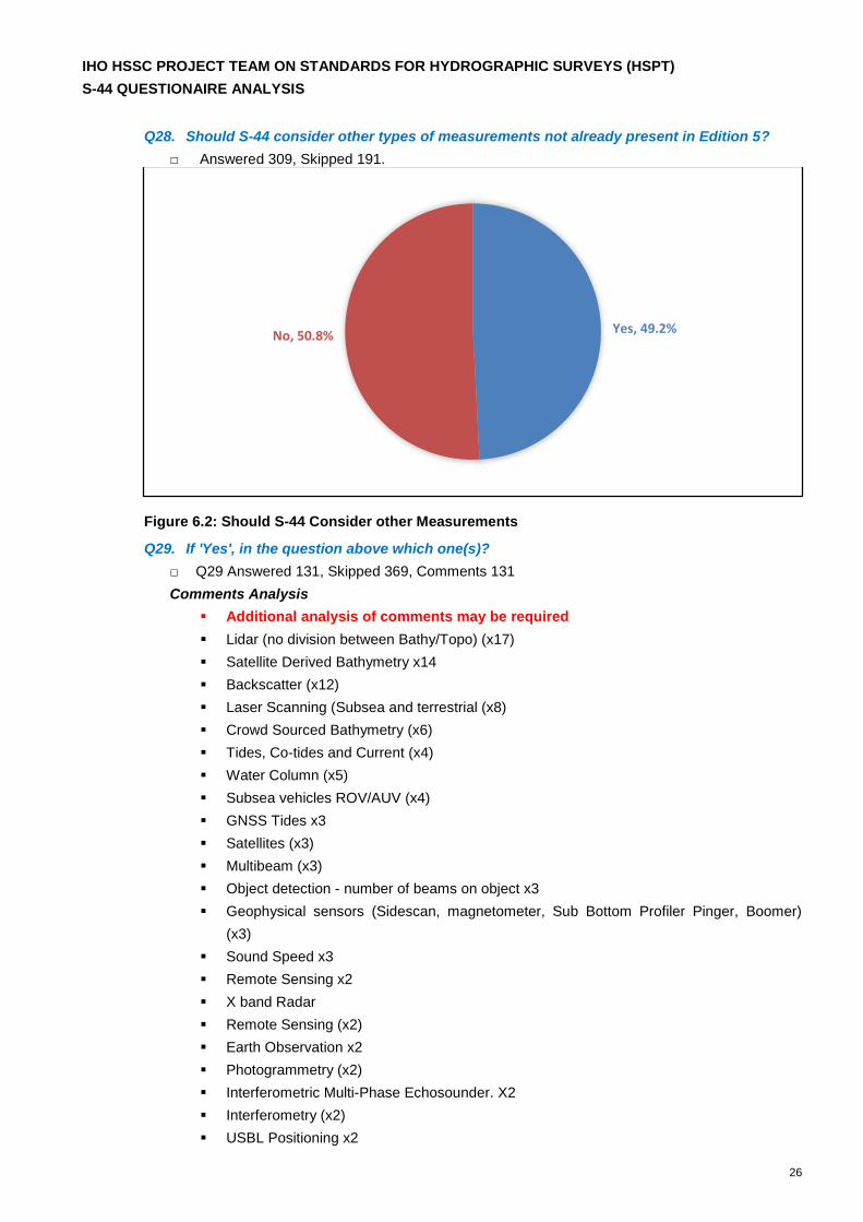
Q28. Should S-44 consider other types of measurements not already present in Edition 5?
□ Answered 309, Skipped 191.
Figure 6.2: Should S-44 Consider other Measurements
Q29. If 'Yes', in the question above which one(s)?
□ Q29 Answered 131, Skipped 369, Comments 131
Comments Analysis
Additional analysis of comments may be required
Lidar (no division between Bathy/Topo) (x17)
Satellite Derived Bathymetry x14
Backscatter (x12)
Laser Scanning (Subsea and terrestrial (x8)
Crowd Sourced Bathymetry (x6)
Tides, Co-tides and Current (x4)
Water Column (x5)
Subsea vehicles ROV/AUV (x4)
GNSS Tides x3
Satellites (x3)
Multibeam (x3)
Object detection - number of beams on object x3
Geophysical sensors (Sidescan, magnetometer, Sub Bottom Profiler Pinger, Boomer)
(x3)
Sound Speed x3
Remote Sensing x2
X band Radar
Remote Sensing (x2)
Earth Observation x2
Photogrammetry (x2)
Interferometric Multi-Phase Echosounder. X2
Interferometry (x2)
USBL Positioning x2
Yes, 49.2%No, 50.8%
IHO HSSC PROJECT TEAM ON STANDARDS FOR HYDROGRAPHIC SURVEYS (HSPT)
S-44 QUESTIONAIRE ANALYSIS
27
LBL Positioning x2
Magnetics x2
Depth Senor Accuracies /Pressure to Depth Calculations (x2)
Aerial Drone x2
VORF or similar (x2)
Acoustic Scanning
Gravitational
ADCP
Synthetic Aperture Sonar
Tidal Streams
Reflectivity Data (Lidar)
Magnetometer
Density of fluid Mud
GNSS Horizontal Datum Transformations
Equipment Certification
Airborne Hyperspectral Bathymetry
Land Heights
UAV surveys
Sensor Calibrations
Seabed Classification
MBES Multi Ping, Multi Freq
Oceanographic Measurements
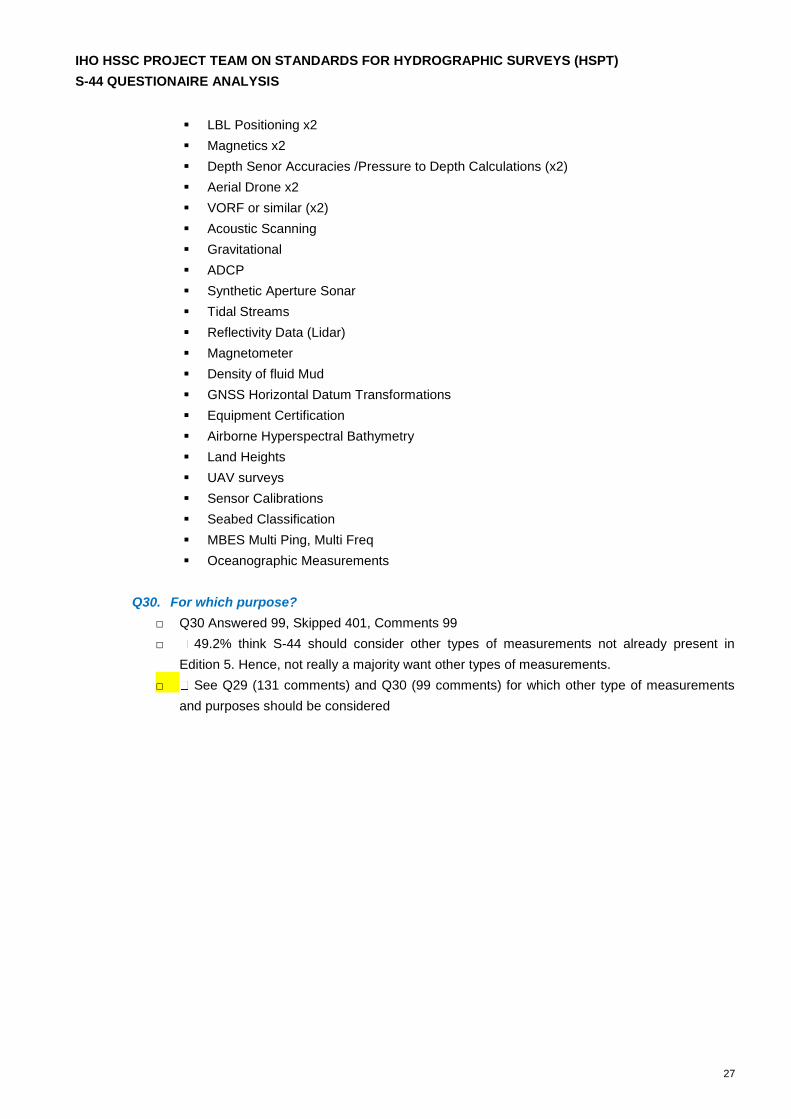
Q30. For which purpose?
□ Q30 Answered 99, Skipped 401, Comments 99
□ 49.2% think S-44 should consider other types of measurements not already present in
Edition 5. Hence, not really a majority want other types of measurements.
□ See Q29 (131 comments) and Q30 (99 comments) for which other type of measurements
and purposes should be considered
IHO HSSC PROJECT TEAM ON STANDARDS FOR HYDROGRAPHIC SURVEYS (HSPT)
S-44 QUESTIONAIRE ANALYSIS
28
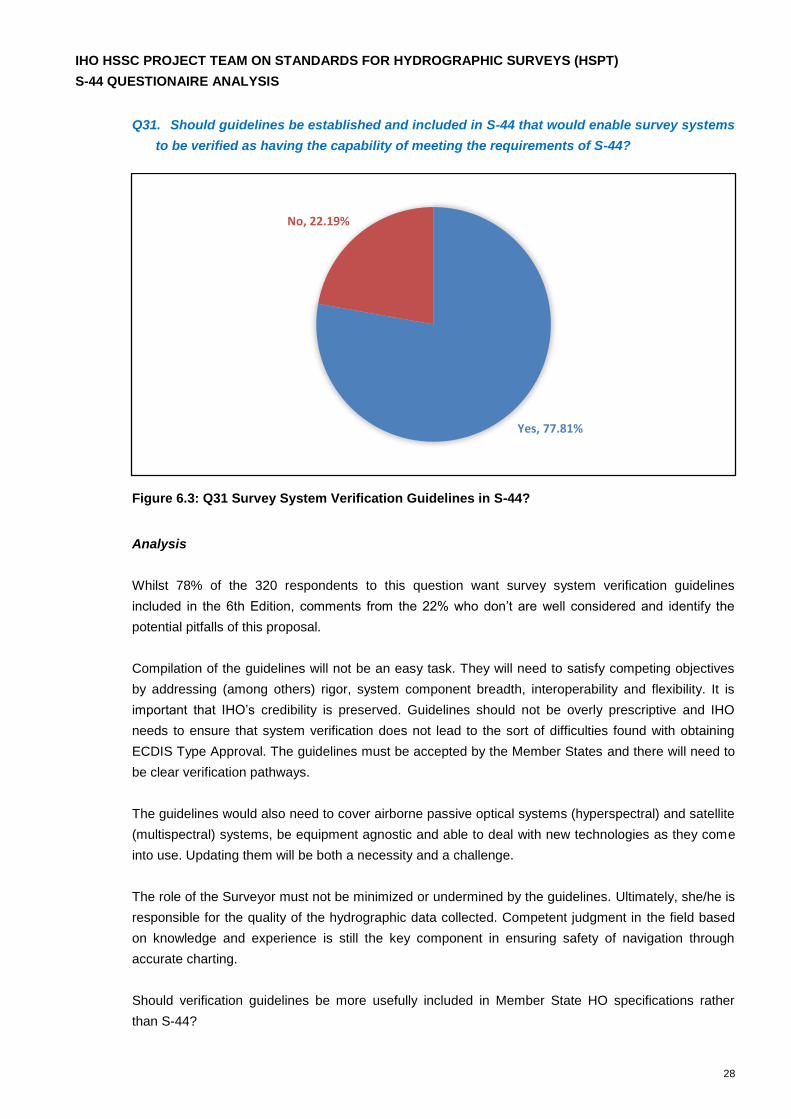
Q31. Should guidelines be established and included in S-44 that would enable survey systems
to be verified as having the capability of meeting the requirements of S-44?
Figure 6.3: Q31 Survey System Verification Guidelines in S-44?
Analysis
Whilst 78% of the 320 respondents to this question want survey system verification guidelines
included in the 6th Edition, comments from the 22% who don’t are well considered and identify the
potential pitfalls of this proposal.
Compilation of the guidelines will not be an easy task. They will need to satisfy competing objectives
by addressing (among others) rigor, system component breadth, interoperability and flexibility. It is
important that IHO’s credibility is preserved. Guidelines should not be overly prescriptive and IHO
needs to ensure that system verification does not lead to the sort of difficulties found with obtaining
ECDIS Type Approval. The guidelines must be accepted by the Member States and there will need to
be clear verification pathways.
The guidelines would also need to cover airborne passive optical systems (hyperspectral) and satellite
(multispectral) systems, be equipment agnostic and able to deal with new technologies as they come
into use. Updating them will be both a necessity and a challenge.
The role of the Surveyor must not be minimized or undermined by the guidelines. Ultimately, she/he is
responsible for the quality of the hydrographic data collected. Competent judgment in the field based
on knowledge and experience is still the key component in ensuring safety of navigation through
accurate charting.
Should verification guidelines be more usefully included in Member State HO specifications rather
than S-44?
Yes, 77.81%
No, 22.19%
IHO HSSC PROJECT TEAM ON STANDARDS FOR HYDROGRAPHIC SURVEYS (HSPT)
S-44 QUESTIONAIRE ANALYSIS
29
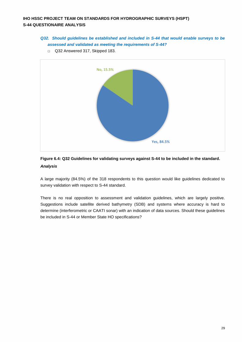
Q32. Should guidelines be established and included in S-44 that would enable surveys to be
assessed and validated as meeting the requirements of S-44?
□ Q32 Answered 317, Skipped 183.
Figure 6.4: Q32 Guidelines for validating surveys against S-44 to be included in the standard.
Analysis
A large majority (84.5%) of the 318 respondents to this question would like guidelines dedicated to
survey validation with respect to S-44 standard.
There is no real opposition to assessment and validation guidelines, which are largely positive.
Suggestions include satellite derived bathymetry (SDB) and systems where accuracy is hard to
determine (interferometric or CAATI sonar) with an indication of data sources. Should these guidelines
be included in S-44 or Member State HO specifications?
Yes, 84.5%
No, 15.5%

IHO HSSC PROJECT TEAM ON STANDARDS FOR HYDROGRAPHIC SURVEYS (HSPT)
S-44 QUESTIONAIRE ANALYSIS
30
Q33. Should S-44 include additional guidelines/standards for other activities such as
backscatter, water column data?
Figure 6.5: Should S-44 Include Additional Guidelines for other Activities
Analysis
More than three quarters (78%) of the 318 respondents think S-44 should include additional guidelines
for other activities. These include:
Backscatter
Water column data
Guidelines for calibrated sea bottom reflectance (from LiDAR, multispectral and
hyperspectral systems
Minimum requirements for SVP dips
Reflectivity/intensity plots
ADCP
They should be equipment agnostic and respondents are evenly divided between wanting guidelines
or a standard, with many suggesting C-13 may be a more appropriate place for them.
Yes
No
IHO HSSC PROJECT TEAM ON STANDARDS FOR HYDROGRAPHIC SURVEYS (HSPT)
S-44 QUESTIONAIRE ANALYSIS
31
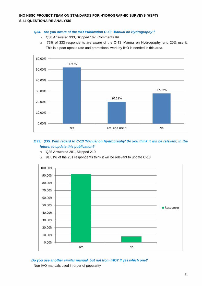
Q34. Are you aware of the IHO Publication C-13 ‘Manual on Hydrography’?
□ Q30 Answered 333, Skipped 167, Comments 99
□ 72% of 333 respondents are aware of the C-13 ‘Manual on Hydrography’ and 20% use it.
This is a poor uptake rate and promotional work by IHO is needed in this area.
Q35. Q35. With regard to C-13 'Manual on Hydrography' Do you think it will be relevant, in the
future, to update this publication?
□ Q35 Answered 281, Skipped 219
□ 91.81% of the 281 respondents think it will be relevant to update C-13
Do you use another similar manual, but not from IHO? If yes which one?
Non IHO manuals used in order of popularity
51.95%
20.12%
27.93%
Yes Yes. and use it No
0.00%
10.00%
20.00%
30.00%
40.00%
50.00%
60.00%
Yes No
0.00%
10.00%
20.00%
30.00%
40.00%
50.00%
60.00%
70.00%
80.00%
90.00%
100.00%
Responses
IHO HSSC PROJECT TEAM ON STANDARDS FOR HYDROGRAPHIC SURVEYS (HSPT)
S-44 QUESTIONAIRE ANALYSIS
32
USACE (14)
NOAA (11)
Admiralty Manual (8)
IMCA (7)
LINZ HYSPEC (6)
Handbook of Offshore Surveying/Skill Trade Tutorials
Various Member State HO specifications (5)
In house specifications (5)
Comparison with Q12 – What Standard do you use?
Standards based on S-44 (28)
Clients specifications (21)
In house specifications (10)
USACE (6)
S-44 (4)
In terms of Q34B, although respondents were asked to identify non-IHO manuals, both the NOAA
Hydrographic Surveys Specifications and Deliverables and LINZ HYSPEC are based on S-44.
Standards based on S-44 are therefore the most widely used by respondents to both Q12 & Q34B.
USACE specifications are widely used but have not been updated for some time. However, their
continued use indicates a lack of other definitive standards for inland waterway surveys.
Based on the survey responses, there is a case for updating C-13 as it currently stands but also for
broadening its scope. C-13 focuses primarily on nautical charting and there is clearly an appetite for
broadening C-13 as a definitive hydrographic manual covering all hydrographic disciplines including
coastal zone management, industrial offshore surveying (UKOOA, IMCA, oil & gas industry
specifications) surveys for scientific and oceanographic research and inland waterways (USACE). This
will be a major undertaking. However there is a clear need and, although not a priority for the HSPT,
IHO would be well placed to lead this project in cooperation with others. See also Q38 comments
below.
Q36. Are you or your organisation considering using crowdsourced bathymetry data in your
products in the future?
Analysis
46.4% consider using crowdsourced in the future. Although a minority of the respondents to this
survey, there are sufficient numbers now considering using crowdsourced data that S-44 needs to
address how to control its use and the minimum standards that would apply; particularly calibration,
data quality, accuracy and liability.
Q37. Is your organisation moving its focus from point measurements to bathymetric
surfaces?
Analysis

IHO HSSC PROJECT TEAM ON STANDARDS FOR HYDROGRAPHIC SURVEYS (HSPT)
S-44 QUESTIONAIRE ANALYSIS
33
58% are considering use of bathymetric surfaces and 30.4% are considering it as possibility in the
future. Standards need to be formulated for the creation of bathymetric surfaces from point
measurements. However the S-100 Working Group is currently working in this area, particularly with
respect to S-102, and HSPT doesn’t need to duplicate this work.
Q38. Do you have any further comments on possible evolutions of the S-44 not previously
addressed by this questionnaire?
Analysis
84 useful comments provided. Underlining the responses is the fundamental assumption that the core
role of S-44 remains the definition of standards to be achieved for orders of survey and for the
standards to be equipment/process independent. Respondents have made suggestions for
enhancement rather than for wholesale changes.
S-44 enhancement
S-44 to be expanded to cover all hydrographic disciplines (x4)
S-44 to address data processing standards (is this not covered by S-57, S-58 & S-63
already?) (x2)
Matrix approach required to enhance Table 1
S-44 should only focus on safety of navigation (SoN)
S-44 to consist of ‘building blocks’/modular from which to develop survey systems and for
future evolution
S-44 to be output focused
S-44 to provide standards for use of crowd sourced bathymetry
S-44 to provide standards for LiDAR, X-band Radar, interferometric sonars and SDB
outputs
S-44 to include standards covering combinations of measurement techniques
S-44 to address difference between S-44 & CATZOC
S-44 to include a metadata standard (is this already dealt with by an existing IHO
standard?)
S-44 to cover SDB & Airborne Hyperspectral Bathymetry (AHB) i.e.
1. Order 3 (new Order less than 2) for SDB
2. Special, 1 & 2 for AHB restricted as to depth. Minimum depth for each order of survey to be
specified or a new equation of TVU adopted for AHB
Keep it simple!
Adaptability/flexiblilty necessary to deal with technological developments and data requirements
Transparent confidence levels required for the calculation of bin sizes and morphologic influences
S-44 to only address MBES? (No!)
S-44 to include an error budget
S-44 to include sections for acoustic, optic and radar-band surveys
IHO HSSC PROJECT TEAM ON STANDARDS FOR HYDROGRAPHIC SURVEYS (HSPT)
S-44 QUESTIONAIRE ANALYSIS
34
More emphasis on feature detection is considered essential
S-44 to include a standard for RTK tide
Bathymetric surfaces (BS)/S-100/S-102
Several respondents want S-44 to address bathymetric surfaces. This is part of the work S-100WG is
doing and need only be cross referenced by the HSPT.
BS standards for ports, harbours and approaches and current/future orders
Correlation between S-44 & S-100 i.e. data acquisition standard/specification for the
layers that need physical measurement
Transform BS uncertainty from two dimensions to one
Superimpose S-44 compliant layers on ENC’s
Data QC for MBES & LiDAR point clouds, combined surface analysis and data resolution
in the case of BS data validation
C-13 Manual on Hydrography/broader IHO policy
Several comments were better suited for inclusion in an updated C-13 or by wider IHO
policy
Guidance required to address liability with respect to defects in hydrographic data supply
chains
Expand C-13 from safety of navigation to cover all hydrography disciplines
C-13 to comment on IBSC Category A & B qualifications
C-13 to include mathematical approach to measurement and calibrations
How to detect satellite data spoofing/blockage?
IHO to provide guidance on the impact of surveying/seismic sound sources on marine life
– particularly mammals – and mitigation measures
S-44 & C-13 to be continuously updated
Guidance on survey campaign planning required
Guidance to address data integrity & promote best practice