international boundary and water commission united … · international boundary and water...
TRANSCRIPT
International Boundary and Water Commission United States Section
Work Plan
Rio Grande Flood Control System Rehabilitation Program at Lower Rio Grande Valley
January 25, 2006
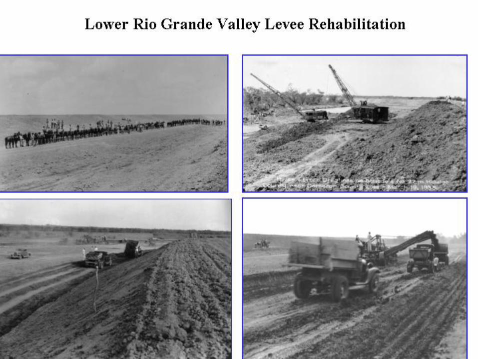
Program/Project Description A. Background - Numerous miles of interior floodways and levees were constructed by the
IBWC under various flood control projects to protect the public and adjacent lands from floods. These floodways and levees comprise the Project. The main purpose of the levees is to constrain river meandering (movement of the international boundary), hence providing flood protection to many Texas cities including El Paso, Presidio, McAllen-Mission, Harlingen, and Brownsville, as well as their respective sister cities in Mexico. The projects located within the United States are operated and maintained by the USIBWC to assure achievement of the purposes of the Project, and Mexico maintains its portion of the levees and floodways.
B. Summary of Program - The Rehabilitation Program, originally funded in 2001, is a multi-
year effort to evaluate and rehabilitate, where necessary, 520 miles of U.S. river and interior floodways levees. The project focuses only on the Lower Rio Grande Flood Control Project (LRGFCP), Presidio Flood Control Project, and Rectification Flood Control Project. From 2001 to 2004, the program was primarily investigative. In 2000, the USIBWC and US Army Engineering Research and Development Center, Vicksburg, entered into a Memorandum of Understanding (MOU IBM 01-12) to conduct a condition assessment of the levee system. This included aerial geophysical methods: multi-frequency electromagnetic (EM), digital video, magnetometer, and high resolution topography using Light Detection and Ranging (LIDAR). A comprehensive enterprise GIS system was developed to integrate, analyze and display data. In this way, historical, geological, geophysical, and other derivative product data could be combined. A condition assessment model was developed using numerical quantitative and qualitative criteria, and a rating system was used to rank all areas of the levee system. Ten criteria were used in the model, and three criteria - geology, levee slope stability, and material type – were felt to be the most significant in terms of levee integrity. These criteria were used to identify areas that needed structural improvements. Areas were also identified where there is freeboard encroachment or levee overtopping. The encroachment and overtopping information was obtained from the 2003 USIBWC hydraulic model for the LRGFCP. From the data sets, levee reaches in the LRGFCP requiring structural improvements or raising were identified and prioritized based on proximity to urban areas or high potential for downstream flooding, such as below the floodway diversion points. The areas that were identified are those further discussed below.
__________________________________________________________________________ This document is provided for information purposes only.
RGF-LRGV Work Plan Page 2 of 4 Performance Goals A. Performance Objective - For the purposes of this Work Plan, the projects identified below
are only for the Lower Rio Grande Flood Control Project and are estimated to cost approximately $125 M. Cost for the work has increased from the 2004 work plan due to inclusion of river levees subject to freeboard encroachment, and the interior floodway system. The 2004 workplan addressed only areas where there was levee overtopping. In addition, costs for levee surfacing, environmental mitigation, and inflation have been added and the contingency increased.
1. City of Hidalgo Protective Work $11.4 M
(Main Floodway South to Lateral A)
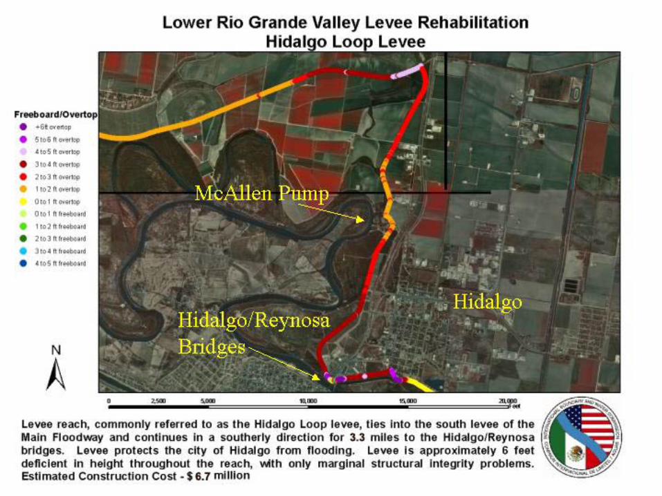
a. Main Floodway South Levee to Hidalgo/Reynosa Bridge - 3.3 miles ($6.69M)
Description - Levee reach, commonly referred to as the Hidalgo Loop levee, ties into the south levee of the Main Floodway and continues in a southerly direction for 3.3 miles to the Hidalgo/Reynosa bridges. Levee protects the city of Hidalgo from flooding. Levee is approximately 6 feet deficient in height throughout the reach, with only marginal structural integrity problems.
b. New Levee - 1.2 miles ($4.71M)
Description - Existing levee extends approximately from the Hidalgo/Reynosa bridges east to beyond the historic San Juan pumping station. The middle segment of the levee reach is approximately 6 feet deficient in height and considered primarily a levee raising project. However, flood protection is approximately 9 feet deficient in height near the historic pump house. The preferred alternative is to relocate the levee to the south side of the historic pump intake canal and cross the intake channel midway between the Hidalgo Reynosa Bridge and the historic pump station. This would require construction of 0.70 miles of new levee on the south side of the old intake channel, and the channel would be crossed to tie the new structure to the existing levee system. Floodwall placement would be required in the vicinity of the Hidalgo Reynosa Bridges.
2. Penitas to Anzalduas $30.5 M
a. Levee Raising - non structural - 12 miles ($21.1M)
Description - The levee within this 12 - mile reach is approximately 5 feet deficient in height. Levee protects several communities from Penitas to Anzalduas dam including

RGF-LRGV Work Plan Page 3 of 4
the residential/industrial interests of Sharyland. Marginal geology (subsurface) concerns exist within this reach of the levee.
b. Structural Rehabilitation - 3.0 miles ($9.40M)
Description - Initial investigations catagorize the geology in the Mission Inlet closure vicinity as poor, thus warranting additional investigations. This area also has historical borrow areas located immediately adjacent to the levee toe. Since its closure, significant development has occurred in the old Mission Floodway. Should the levee breach in this reach, extensive flood damages can be expected. If additional geotechnical investigations suggest corrective action, a subsurface barrier (slurry trench, sheet pilings) will most likely be the proposed alternative. Note: TXDOT has a project in this vicinity.
3. Donna Pump to Retamal Dam - 3 miles $8.8 M
Description - This levee reach connects Retamal Dam into the levee system and is commonly referred to as Retamal Dike. The purpose of Retamal Dam is to divert flood flows into the Mexican floodway. Failure of Retamal Dike would result in uncontrolled flows downstream of Retamal Dam. Initial geotechnical investigations indicated structural integrity problems with Retamal Dike. Large cracks exists on the surface and within the core of the levee. Additional investigations have been conducted and indicate that the presence of clay layers that were severely dehydrated caused these problems. A test pond simulating an in situ test in November 2004 showed little leakage under a typical flood hydrograph scenario.
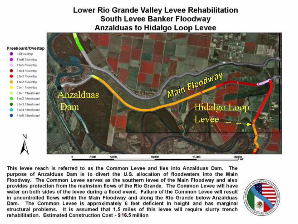
4. Anzalduas to beginning of Hidalgo Loop levee- 5.25 miles $16.5 M
Description - This levee reach is referred to as the Common Levee and ties into Anzalduas Dam. The purpose of Anzalduas Dam is to divert the U.S allocation of floodwaters into the Main floodway. The Common Levee serves as the southern levee of the Main Floodway and also provides protection from mainstem flows of the Rio Grande. The Common Levee will have water on both sides of the levee during a flood event. Failure of the Common levee will result in uncontrolled flows below Anzalduas Dam. The Common Levee is approximately 6 feet deficient in height and has marginal structure problems. It is assumed that 1.5 miles of this levee will require rehabilitation using slurry trench techniques.
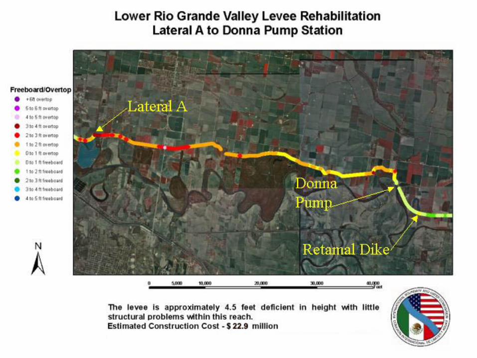
5. Lateral A (Hidalgo) to Donna Pump Sta - 11 miles $22.9 M
Description - The levee is approximately 4.5 feet deficient in height with little structural problems within this reach.
RGF-LRGV Work Plan Page 4 of 4
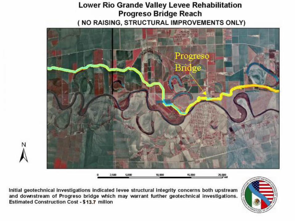
6. Progreso Bridge Area - 5 miles $13.7 M (FM 88 to Mercedes Pump Sta.)
Description - Initial geotechnical investigations indicated levee structural integrity concerns both upstream and downstream of Progreso bridge which may warrant further geotechnical investigations.
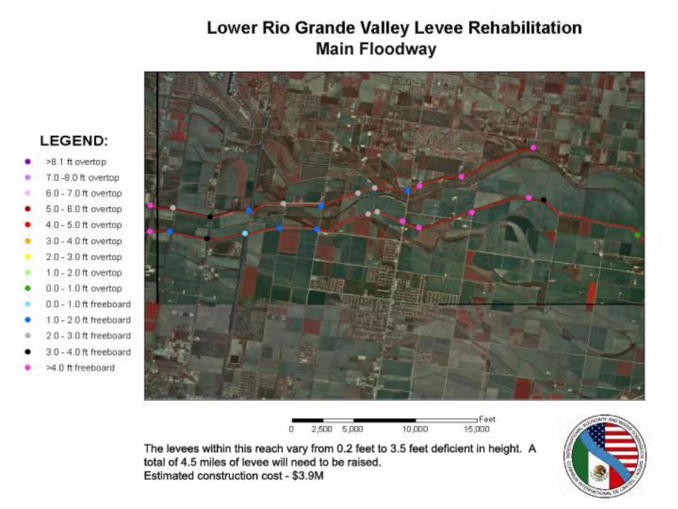
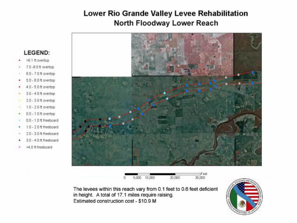
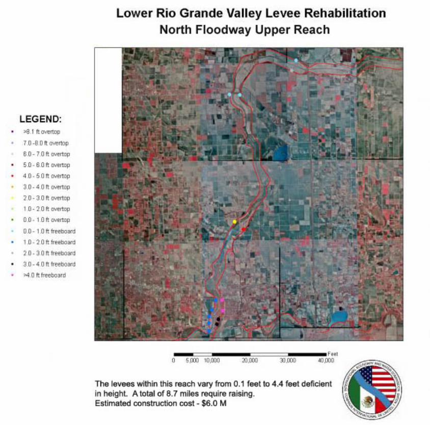
7. Interior Floodway Levee Rehabilitation - 29.4 miles $20.8 M
Description - Approximately 1 mile of levee is up to 3-4 feet deficient in height, the remaining distance is approximately 0.5 feet deficient in height. No structural integrity problems are anticipated.
B. Project Schedule - The attached Schedule is an outlook for the next four years.
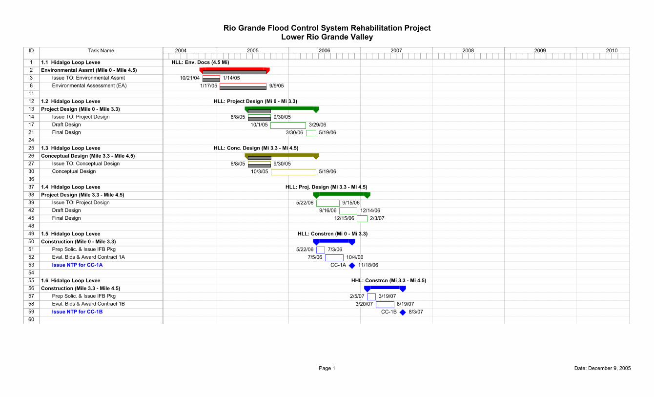
ID Task Name
1 1.1 Hidalgo Loop Levee2 Environmental Assmt (Mile 0 - Mile 4.5)3 Issue TO: Environmental Assmt6 Environmental Assessment (EA)
1112 1.2 Hidalgo Loop Levee13 Project Design (Mile 0 - Mile 3.3)14 Issue TO: Project Design17 Draft Design21 Final Design2425 1.3 Hidalgo Loop Levee26 Conceptual Design (Mile 3.3 - Mile 4.5)27 Issue TO: Conceptual Design30 Conceptual Design3637 1.4 Hidalgo Loop Levee38 Project Design (Mile 3.3 - Mile 4.5)39 Issue TO: Project Design42 Draft Design45 Final Design4849 1.5 Hidalgo Loop Levee50 Construction (Mile 0 - Mile 3.3)51 Prep Solic. & Issue IFB Pkg52 Eval. Bids & Award Contract 1A53 Issue NTP for CC-1A5455 1.6 Hidalgo Loop Levee56 Construction (Mile 3.3 - Mile 4.5)57 Prep Solic. & Issue IFB Pkg58 Eval. Bids & Award Contract 1B59 Issue NTP for CC-1B60
HLL: Env. Docs (4.5 Mi)
10/21/04 1/14/051/17/05 9/9/05
HLL: Project Design (Mi 0 - Mi 3.3)
6/8/05 9/30/0510/1/05 3/29/06
3/30/06 5/19/06
HLL: Conc. Design (Mi 3.3 - Mi 4.5)
6/8/05 9/30/0510/3/05 5/19/06
HLL: Proj. Design (Mi 3.3 - Mi 4.5)
5/22/06 9/15/069/16/06 12/14/06
12/15/06 2/3/07
HLL: Constrcn (Mi 0 - Mi 3.3)
5/22/06 7/3/067/5/06 10/4/06
CC-1A 11/18/06
HHL: Constrcn (Mi 3.3 - Mi 4.5)
2/5/07 3/19/073/20/07 6/19/07
CC-1B 8/3/07
2004 2005 2006 2007 2008 2009 2010
Rio Grande Flood Control System Rehabilitation ProjectLower Rio Grande Valley
Page 1 Date: December 9, 2005
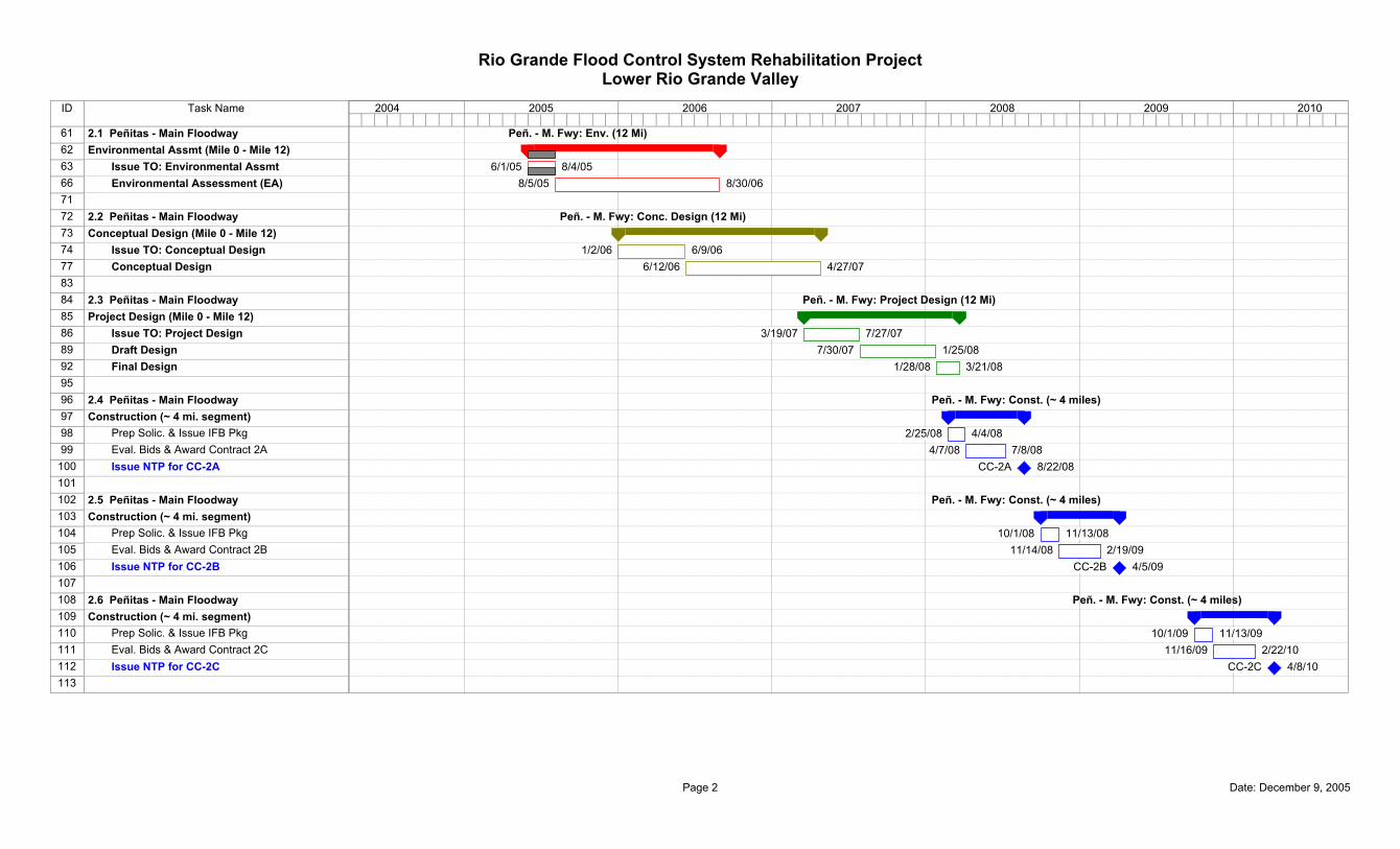
ID Task Name
61 2.1 Peñitas - Main Floodway62 Environmental Assmt (Mile 0 - Mile 12)63 Issue TO: Environmental Assmt66 Environmental Assessment (EA)7172 2.2 Peñitas - Main Floodway73 Conceptual Design (Mile 0 - Mile 12)74 Issue TO: Conceptual Design77 Conceptual Design8384 2.3 Peñitas - Main Floodway85 Project Design (Mile 0 - Mile 12)86 Issue TO: Project Design89 Draft Design92 Final Design9596 2.4 Peñitas - Main Floodway97 Construction (~ 4 mi. segment)98 Prep Solic. & Issue IFB Pkg99 Eval. Bids & Award Contract 2A
100 Issue NTP for CC-2A101102 2.5 Peñitas - Main Floodway103 Construction (~ 4 mi. segment)104 Prep Solic. & Issue IFB Pkg105 Eval. Bids & Award Contract 2B106 Issue NTP for CC-2B107108 2.6 Peñitas - Main Floodway109 Construction (~ 4 mi. segment)110 Prep Solic. & Issue IFB Pkg111 Eval. Bids & Award Contract 2C112 Issue NTP for CC-2C113
Peñ. - M. Fwy: Env. (12 Mi)
6/1/05 8/4/058/5/05 8/30/06
Peñ. - M. Fwy: Conc. Design (12 Mi)
1/2/06 6/9/066/12/06 4/27/07
Peñ. - M. Fwy: Project Design (12 Mi)
3/19/07 7/27/077/30/07 1/25/08
1/28/08 3/21/08
Peñ. - M. Fwy: Const. (~ 4 miles)
2/25/08 4/4/084/7/08 7/8/08
CC-2A 8/22/08
Peñ. - M. Fwy: Const. (~ 4 miles)
10/1/08 11/13/0811/14/08 2/19/09
CC-2B 4/5/09
Peñ. - M. Fwy: Const. (~ 4 miles)
10/1/09 11/13/0911/16/09 2/22/10
CC-2C 4/8/10
2004 2005 2006 2007 2008 2009 2010
Rio Grande Flood Control System Rehabilitation ProjectLower Rio Grande Valley
Page 2 Date: December 9, 2005
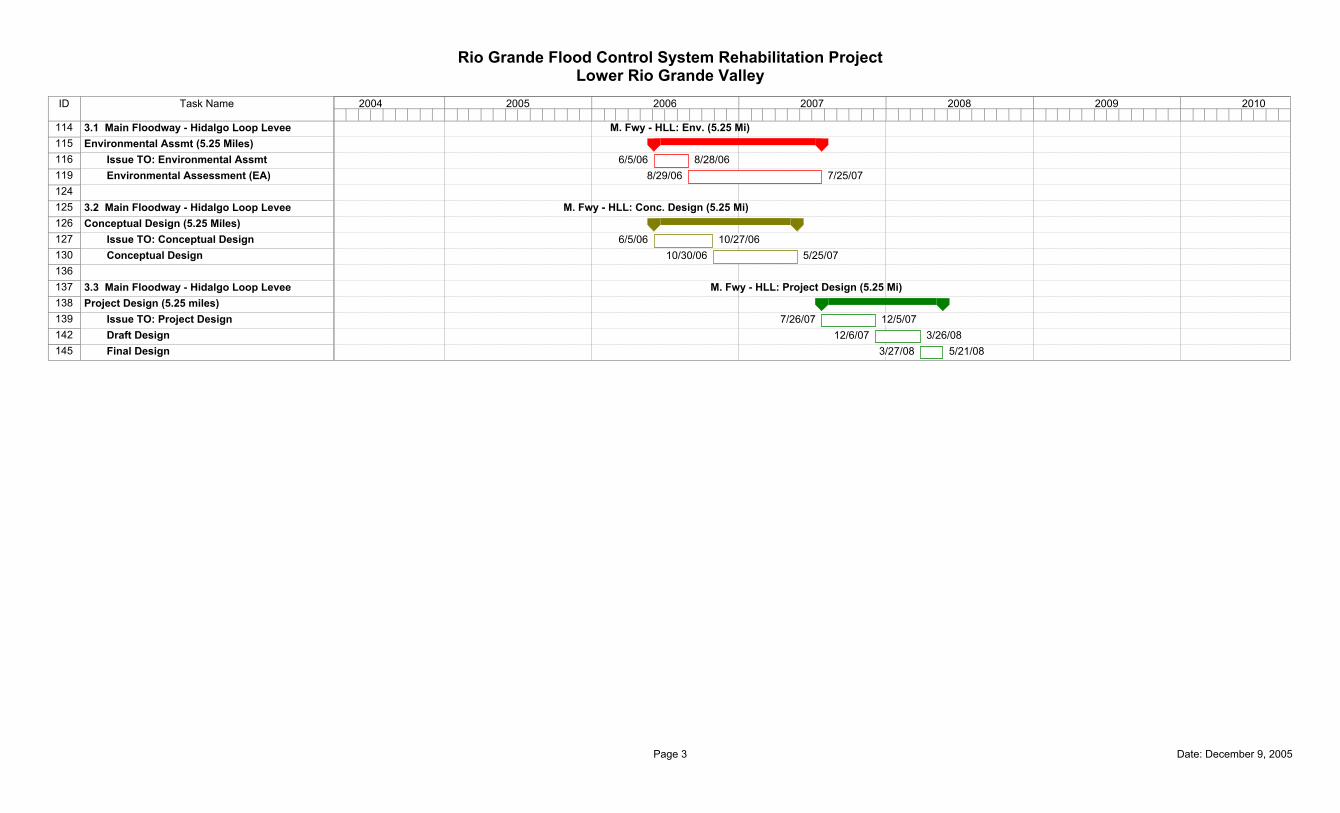
ID Task Name
114 3.1 Main Floodway - Hidalgo Loop Levee115 Environmental Assmt (5.25 Miles)116 Issue TO: Environmental Assmt119 Environmental Assessment (EA)124125 3.2 Main Floodway - Hidalgo Loop Levee126 Conceptual Design (5.25 Miles)127 Issue TO: Conceptual Design130 Conceptual Design136137 3.3 Main Floodway - Hidalgo Loop Levee138 Project Design (5.25 miles)139 Issue TO: Project Design142 Draft Design145 Final Design
M. Fwy - HLL: Env. (5.25 Mi)
6/5/06 8/28/068/29/06 7/25/07
M. Fwy - HLL: Conc. Design (5.25 Mi)
6/5/06 10/27/0610/30/06 5/25/07
M. Fwy - HLL: Project Design (5.25 Mi)
7/26/07 12/5/0712/6/07 3/26/08
3/27/08 5/21/08
2004 2005 2006 2007 2008 2009 2010
Rio Grande Flood Control System Rehabilitation ProjectLower Rio Grande Valley
Page 3 Date: December 9, 2005