interim management guidelines for the nullarbor caves and selected karst … · 2015-01-19 ·...
TRANSCRIPT

Interim Management Guidelines for the Nullarbor Caves and Selected Karst Features Western Australia Department of Environment and Conservation
and the Rangelands NRM Co-ordinating Group
i Geoscene International
Division of Scenic Spectrums Pty Ltd WPDOCS: Nullarbor/FinRpt/NullarborIMG_310109

Interim Management Guidelines for the Nullarbor Caves and Selected Karst Features Western Australia Department of Environment and Conservation
and the Rangelands NRM Co-ordinating Group
i Geoscene International
Division of Scenic Spectrums Pty Ltd WPDOCS: Nullarbor/FinRpt/NullarborIMG_310109

Interim Management Guidelines for the Nullarbor Caves and Selected Karst Features Western Australia Department of Environment and Conservation
and the Rangelands NRM Co-ordinating Group
ii Geoscene International
Division of Scenic Spectrums Pty Ltd WPDOCS: Nullarbor/FinRpt/NullarborIMG_310109
Acknowledgements The Nullarbor Karst IMG Project was initiated during March, 2007. During that time, a wide range of persons have been involved in the project, volunteering contributions through the Steering Committee or through consultations and other assistance. The time and contributions of these people has been greatly appreciated and is acknowledged with thanks. Steering Committee Members have included: Department of Environment and Conservation, Western Australia:
• Alan Danks (South Coast Regional Nature Conservation Leader, Albany) • Julie Patten (Esperance District Nature Conservation Coordinator) • Klaus Tiedemann (Esperance District Manager)
Australian Government Natural Resource Management Team: • Neil Riches (NRM Facilitator – Biodiversity, Western Australian Team)
Rangelands NRM Team:
• Sylvia Clarke (Southern Rangelands Biodiversity Coordinator, Kalgoorlie) • Renee Berry ( Southern Rangelands Biodiversity Coordinator, Kalgoorlie)
Department of Indigenous Affairs, Western Australia:
• Kymberley Russell (Senior Projects Officer, Kalgoorlie)
Goldfields Land and Sea Council: • Dennis Forrest (Project Officer, Kalgoorlie) • Phil Drayson (Land Unit Coordinator, Perth)
Western Australia Museum: • Dr. Bill Humphreys (WA Museum)
Pastoralists: • Peter Brown AM and Barbara Brown (Pastoral Leaseholders – Arubiddy Station); • Colin and Bree Campbell (Pastoral Leaseholders – Mundrabilla Station)
Speleologists, Cave Divers and Cave Researchers: • Jay Anderson (Caver; Representing the ASF /former Australian Speleological
Federation President); • Paul Hosie (Cave diver; Representing Cave Exploration Group of South Australia –
CEGSA -, who are the key custodians of Nullarbor Karst identification and location information);
• Dr. Stefan Eberhard (Caver, researcher, co-author of the Subterranean Biodiversity of the Nullarbor Karst Desktop Study, caving consultant - Subterranean Ecology)
• Ann Marie Meredith (Caver; WA Speleological Group member); • Norman Poulter OAM (ASF member, caver; researcher) • Eve Taylor (Speleological Research Group WA / caver, researcher) • Paul Devine (Speleological Research Group WA / caver, researcher) • Rauleigh Webb (ASF member, caver; researcher).

Interim Management Guidelines for the Nullarbor Caves and Selected Karst Features Western Australia Department of Environment and Conservation
and the Rangelands NRM Co-ordinating Group
iii Geoscene International
Division of Scenic Spectrums Pty Ltd WPDOCS: Nullarbor/FinRpt/NullarborIMG_310109
Other individuals who have been consulted, assisted the preparation of the report or provided photography have included: Mirning and Ngadju Traditional Owners Consulted:
• Eddie McKenzie – Goldfields Land & Sea Council and Ngadju Aboriginal People • Clem Lawrie –Mirning Aboriginal People • Michael Laing –Mirning Aboriginal People • Johnny Graham – Ngadju Aboriginal People • Rule Wicker– Ngadju Aboriginal People
Australian Speleological Federation and Australian Cave and Karst Management Association members:
• Peter Ackroyd (ASF, caver, researcher) • Fr. Ken Boland (ASF, caver, researcher) • Peter Dykes (member of Australian Speleological Federation, Convenor of ASF
Commission for Aboriginal and Torres Strait Island Cultural Matters, botanist) • Professor Elery Hamilton-Smith AM (Chairman IUCN Cave and Karst Management
Committee) • Professor Julia James (ASF, karst researcher, University of Sydney) • Graham Pilkington (CEGSA President, caver, researcher)
Government personnel:
• Vanessa Bray (Land Unit Management Assistant, Perth) • Sarah Comer (Regional Ecologist, South Coast Region, Albany) • Penny O’Conner, Manager Assessment & Registration, Heritage Council of Western
Australia) • Kathryn Przywolnik (Archaeologist, Dept. of Indigenous Affairs, WA) • Dr. John Watson (South Coast Strategic Land Use Planner, previously the DEC
South Coast Regional Manager) Photographers:
• Chris Bradley (National University Caving Club) • Olaf Theden (National University Caving Club) • Norman Poulter OAM (ASF member, caver; researcher) • Klaus Tiedemann (District Manager, DEC Esperance)
Organisations consulted and surveyed during 2007 by DEC:
• Australian Speleological Federation (ASF) • Cave Divers Association of Australia (CDAA) • Department of Environment and Conservation (DEC) • Department of Indigenous Affairs (DIA) • Department of Planning and Infrastructure (DPI) • Fire & Emergency Services Authority (FESA) • Goldfields and Esperance Development Commission (GEDC) • Shaw Horizons (Tourism Operators) • Shire of Dundas • Speleological Research Group of Western Australia (SRGWA) • Tourism Western Australia

Interim Management Guidelines for the Nullarbor Caves and Selected Karst Features Western Australia Department of Environment and Conservation
and the Rangelands NRM Co-ordinating Group
iv Geoscene International
Division of Scenic Spectrums Pty Ltd WPDOCS: Nullarbor/FinRpt/NullarborIMG_310109
Acronyms ACKMA Australian Cave and Karst Management Association ARTC Australian Rail Track Corporation Ltd ASF Australian Speleological Federation CAC Caves Access Committee CALM former Dept. of Conservation and Land Management CDAA Cave Divers Association of Australia CEGSA Cave Exploration Group (South Australia) Inc. CLAP Cave Leader Assessment Panel CLMR Conservation and Land Management Regulations 2002 CMAC Caves Management Advisory Committee DEC Dept. of Environment and Conservation DEWHA Dept. of Environment, Water, Heritage and the Arts DIA Dept. of Indigenous Affairs DIR Dept of Industry and Resources DOLA former Dept. of Lands and Agriculture DMPR Dept. of Mineral and Petroleum Resources DPI Dept. of Planning and Infrastructure DWR Dept. of Water Resources EPA Environment Protection Authority EPBA Environment Protection and Biodiversity Conservation Act 1999 FESA Fire and Emergency Services Authority GEDC Goldfields & Esperance Development Commission GLSC Goldfields Land and Sea Council HREOC Human Rights and Equal Opportunities Commission IBRA Interim Biogeographical Regionalisation for Australia IMG Interim Management Guideline(s) IUCN International Union for Conservation of Nature KIDSA Karst Index Database – South Australia LAA Land Administration Act 1997 LAC Limits of Acceptable Change LCDC Land Conservation District Committees MATs Management Action Targets NCKMAC Nullarbor Caves and Karst Management Advisory Committee NHT Natural Heritage Trust NLP National Landcare Program NRM Natural Resource Management NRS National Reserve System NUCC National University Caving Club PGA Pastoralists and Graziers Association PLB Pastoral Lands Board SEIG Statutory Exploration Information Group SRGWA Speleological Research Group of Western Australia SLS State Land Services TOMM Tourism Optimisation Management Model RAOU Royal Australian Ornithologists Union UNESCO RAS Register of Aboriginal Sites RATIS Recreation and Tourism Information System RCTs Resource Condition Targets ROS Recreation Opportunity Spectrum VAMP Visitor Activity Management Process VERP Visitor Experience Resource Protection VIM Visitor Impact Management WAFF Western Australian Farmers Federation WAHC Western Australian Heritage Council WAM Western Australian Museum WARMS Western Australian Rangeland Monitoring System WASG Western Australian Speleological Group WCPA World Commission on Protected Areas ZCA Zone Control Authorities

Interim Management Guidelines for the Nullarbor Caves and Selected Karst Features Western Australia Department of Environment and Conservation
and the Rangelands NRM Co-ordinating Group
v Geoscene International
Division of Scenic Spectrums Pty Ltd WPDOCS: Nullarbor/FinRpt/NullarborIMG_310109
CONTENTS Acknowledgements ii Acronyms iii 1. Executive Summary and Key Recommendations 1 2. Project Background 3 2.1 Project Aims and Objectives 3 2.2 Key Focus Attributes and Assets Addressed 4 2.3 Potential Uses Considered 4 2.4 Key Management Activities 5 2.5 Funding Agencies and Steering Committee 5
2.5.1 A Joint Initiative 5 2.5.2 Project Management and Consultations 5
2.6 Project Area and Overview Description 5 2.6.1 Geographic Area 5 2.6.2 Physiographic Units, Biogeographic Subregions
and Vegetation 8 2.6.3 Climate 13 2.6.4 Caves and Karst Features of the Nullarbor 13 2.6.5 Coastal Features 15 2.6.6 Transportation Routes, Settlements and Facilities 15 2.6.7 Indigenous Heritage 15 2.6.8 Non-Indigenous Heritage 16 2.6.9 Land Use and Economic Sectors 17
2.7 Overall Significance 17 3. Land Tenure, Legislative and Management Framework 20 3.1 Land Tenure 20 3.2 Conservation Estate 22 3.3 Legislative and Management Framework 22 4 Key Focus Features, Values and Significance 22 4.1 Focus Cave and Karst Features 22 4.2 Extremely High Overall Environmental and Cultural
Significance 25 4.3 Key Values of Geologic, Hydrologic and Karst Features 25

Interim Management Guidelines for the Nullarbor Caves and Selected Karst Features Western Australia Department of Environment and Conservation
and the Rangelands NRM Co-ordinating Group
vi Geoscene International
Division of Scenic Spectrums Pty Ltd WPDOCS: Nullarbor/FinRpt/NullarborIMG_310109
4.4 Key Subterranean Ecosystems, Flora and Fauna 26 4.4.1 Overview 26 4.4.2 Values Identified by Subterranean Ecology 26 4.4.3 Subterranean Values Identified by 2002 Biodiversity
Audit, Davey et. al. (1992) and Devine (2007) 32 4.5 Other Key Values Associated with Nullarbor Cave
and Karst Features 33 4.5.1 Associated Values – Overview 33 4.5.2 Paleoenvironmental Values 33 4.5.3 Archaeological Values 34 4.5.4 Surface Ecosystem, Flora and Fauna Values 35 4.5.5 Cultural Heritage Values 37 4.5.6 Natural Heritage Places, Sites and Features 37 4.5.7 Scenic Resources 37 4.5.8 Tourism, Recreation and Wilderness Values,
Facilities and Activities 38 4.5.9 Scientific Research and Education Values 38 5 Key Management Issues 39 5.1 Overview 39 5.2 Key Issue Areas 41 5.3 Ecosystem, Flora and Fauna Issues 43
5.3.1 Surface Ecosystem Recommendations by the 2002 Biodiversity Audit and by McKenzie and Robinson (1987) 43
5.3.2 Subterranean Ecology’s Recommended Conservation and Research Priorities 43
5.4 Use of Caves for Recreational, Research and Other Activities 44 5.4.1 Cave Fragility and Past Damage 44 5.4.2 Types and Level of Use 45 5.4.3 Cave Access Permit System Currently Applied
in the Nullarbor 48 5.4.4 DEC Cave Regulations and Policies 50
5.4.5 Potential Application and Limitations of Existing Cave Regulations and Management Systems 56
5.4.6 Existing Nullarbor Cave Risk Assessment and Its Limitations 56 5.4.7 Potential Application of Cave Management Classification System to Nullarbor Caves 58 5.4.8 Visitor Impact Monitoring and Management 58 5.4.9 Visitor Information Signage and Infrastructure Issues 60

Interim Management Guidelines for the Nullarbor Caves and Selected Karst Features Western Australia Department of Environment and Conservation
and the Rangelands NRM Co-ordinating Group
vii Geoscene International
Division of Scenic Spectrums Pty Ltd WPDOCS: Nullarbor/FinRpt/NullarborIMG_310109
5.5 Pastoral Uses and Potential Impacts on Caves 67 5.5.1 Potential Impacts of Pastoral Uses 67 5.5.2 Rangelands NRM Strategy and Best Practice Guidelines 68 5.5.3 Some Specific Pastoral Issues 69 5.6 Mining Uses and Potential Impacts on Caves 70 5.6.1 Potential Impacts of Mining 70 5.6.2 Mining Guideline Documents 71 5.6.3 Special Focus on Groundwater Issues 72 5.7 Transport and Communications Infrastructure Impacts 76 5.8 Aboriginal Cultural Heritage, Recognition and Co-operation 76 5.9 Safety and Liability 76 5.10 Enhanced Management Frameworks 78 6 Recommended Interim Management Guidelines 79 6.1 Introduction to the Guidelines 79 6.2 Interim Management Guidelines for the General Management
and Use of Caves 79 6.2.1 IMG 1: Vesting of Cave Management 79 6.2.2 IMG 2: Management Advisory Committee 79 6.2.3 IMG 3: Cave Access Permit System 80 6.2.4 IMG 4: Cave Management Classification System 80 6.2.5 IMG 5: Assessment of Cave Risks to Visitors 80 6.2.6 IMG 6: Locked Access for Selected Caves 81 6.2.7 IMG 7: Fencing Cave Reserves within Pastoral
Leaseholds 81 6.2.8 IMG 8: Visitor Impact Monitoring Methods 82 6.2.9 IMG 9: Field Management Staffing Alternatives 82 6.2.10 IMG 10: Cave-Related Capital Works 82 6.2.11 IMG 11: Visitor Interpretation Feasibility Study 83 6.2.12 IMG 12: Groundwater Protection 83
6.2.13 IMG 13: Ecosystem, Flora and Fauna Conservation 83 6.2.14 IMG 14: Threatening Pest Animal and Plant Control 84
6.2.15 IMG 15: Fire Control 85 6.2.16 IMG 16: Protection of Cultural Heritage Sites 85 6.2.17 IMG 17: Holistic and Best Management Practices 85 6.3 Interim Management Guidelines for Specific Pastoral Issues 85 6.3.1 IMG 18: Survey and Fencing of Areas Above Cave
Passages 85 6.3.2 IMG 19: Surface Drainage and Farm Dam Construction 86

Interim Management Guidelines for the Nullarbor Caves and Selected Karst Features Western Australia Department of Environment and Conservation
and the Rangelands NRM Co-ordinating Group
viii Geoscene International
Division of Scenic Spectrums Pty Ltd WPDOCS: Nullarbor/FinRpt/NullarborIMG_310109
6.4 Interim Management Guidelines for Mining, Transport and Communications Infrastructure Uses 86
6.4.1 IMG 20: Excavations and Drilling Above Cave Passages 86 6.4.2 IMG 21: Surface Drainage Changes by Mining, and Infrastructure 87 6.5 Interim Management Guidelines Related to Aboriginal Recognition and Co-operation 87 6.5.1 IMG 22: Aboriginal Rights, Knowledge and Co-operative Management 87 6.6 Interim Management Guidelines Regarding Safety and Liability Issues 88 6.6.1 IMG 23: Risk Assessments and Management 88 6.7 Enhanced Management Frameworks 88 6.7.1 IMG 24: Preliminary Review of Enhanced 88 Management Frameworks 7 Next Steps: Where to from Here? 89 7.1 Introduction 89 7.2 Community Awareness and Consultation 89 7.3 On-going Field Research, Survey Investigations and Cultural
Development 90 7.4 Consideration of Enhanced Management Frameworks 90 7.5 Seeking Potential Funding for Urgent Management Actions and Research 91 FIGURES Figure 1 The W.A. Nullarbor Cave and Associated Features Project Area within the Broader Nullarbor Karst System 6 Figure 2 Beard’s (1975) Physiographic/Vegetation Units 7 Figure 3 Bioclimes for Western Australia 14 Figure 4 Land Tenure of the Karst System with Caves 21 Figure 5 Caves as Known during 1992 23 Figure 6 Cave and Karst Features Known during 2007 24 Figure 7 Overview of Management Issues Regarding the Nullarbor Caves, Dolines, Blowholes and Associated Karst Areas 40 Figure 8 Northwest-Southeast Geological Section of the Eucla Basin 73

Interim Management Guidelines for the Nullarbor Caves and Selected Karst Features Western Australia Department of Environment and Conservation
and the Rangelands NRM Co-ordinating Group
ix Geoscene International
Division of Scenic Spectrums Pty Ltd WPDOCS: Nullarbor/FinRpt/NullarborIMG_310109
TABLES Table 1 Rare and Priority 1 Flora Species in the Nullarbor Cave
and Associated Karst Project Area 35 Table 2 Examples of Schedule 1 and Other Priority Fauna Species in the Nullarbor Cave and Associated Karst Project Area 36 Table 3 Selected Caves in Relation to Pastoral Stations and the DEC Managed Estate by Biodiversity Ranking and Location 49 Table 4 DEC Cave Management Classification System (2006) 54 Table 5 CEGSA Overall Risk Level Assessment Matrix for Caves 57 Table 6 CEGSA Advice Relative to the Overall Cave Risk Levels 57 GLOSSARY 93 REFERENCES 97 APPENDIX 1: Stakeholder Responses to the DEC Survey Undertaken During 2007 as part of the Project: Under the Nullarbor, Assessing and Protecting the Biodiversity Assets of the Nullarbor Karst 105 APPENDIX 2: Heritage Sites and Places on Various Government and Community Registers and Lists 114 APPENDIX 3: Legislative and Management Framework 115 APPENDIX 4: Detailed Summary of the Key Focus Features, Values and Significance of Nullarbor Caves, Blowholes and Dolines 122 APPENDIX 5: Rare and Special Priority Flora Species in the Project Area 137 APPENDIX 6: Rare and Special Priority Fauna Species in the Project Area 139 APPENDIX 7: Frame of Reference Scenic Assessment Criteria 150 APPENDIX 8: CEGSA Cave Prioritisation or Vulnerability Table 151 APPENDIX 9: Enhanced Management Frameworks 155
Editorial Note: Aside from report section headings being placed in bold, selected sections of the main text within the Executive Summary and Section 4 of this report have been highlighted in bold lettering to facilitate quicker reading of key points by the reader. In addition to this reading aid, a Field Managers’ Abbreviated Version of this report has been prepared.

Interim Management Guidelines for the Nullarbor Caves and Selected Karst Features Western Australia Department of Environment and Conservation
and the Rangelands NRM Co-ordinating Group
1 Geoscene International
Division of Scenic Spectrums Pty Ltd WPDOCS: Nullarbor/FinRpt/NullarborIMG_310109
INTERIM MANAGEMENT GUIDELINES FOR THE NULLARBOR CAVES AND SELECTED KARST FEATURES 1. Executive Summary and Key Recommendations The Interim Management Guidelines (IMGs) for caves and selected karst features of the Nullarbor Karst System in Western Australia have been prepared as a joint initiative between the Rangelands Natural Resource Management (NRM) Coordinating Group and the Department of Environment and Conservation’s (DEC) Biodiversity Conservation Initiative – Save our Species program. The current focus area is primarily from the Trans Australian Railway south to the coastline and from the South Australian border west to Point Malcolm. The significance and key existing circumstances of the project area are: 1. the Nullarbor caves and associated features play a critical role in a much larger
karst system that is without question of world and national significance for a range of natural and cultural resources (e.g. geologic, palaeontololgical, archeological, biological etc. and in terms of indigenous and non-indigenous cultural heritage -refer to Section 4);
2. the area receives relatively low visitor numbers due to remoteness, but is extremely fragile and vulnerable, even to the level of use currently received (refer to Section 5);
3. management co-ordination, presence, activity and control over the caves and karst
features is inadequate given the high conservation values and vulnerability of the area (refer to Section 5);
4. the current Cave Access Permit System is inconsistently applied and
unenforceable, primarily due to a lack of public knowledge/co-operation and no field checks on usage (refer to Section 5);
5. there are significant public safety and liability issues (refer to Section 5); 6. there are many untapped opportunities for presentation and interpretation of the
outstanding features of the area to the public and for enhanced conservation measures and research (refer to Section 5).
In lieu of a comprehensive management plan being prepared, this report recommends 24 IMGs for consideration (refer to Section 6). Priority guidelines include: 1. review and consideration of alternatives for field-based conservation officers,
either as trained volunteers, paid staff or some combination, including incentives for assistance from pastoral leaseholders (refer to Section 6);
2. application of the Cave Management Classification System to determine which
caves should be managed as Tourist Caves, Adventure Caves or Restricted Access Caves with more consistent and rigorous application of the Cave Access Permit System (maintaining positive relations with and involvement of Pastoralists and appropriate Aboriginal communities or Traditional Owners – refer to Section 6);
3. conduct assessments of cave risks to visitors for selected caves on a priority basis
(refer to Section 6); 4. consider vesting the overall management of all caves and associated karst features
to a single State Government department (e.g. DEC) with oversight from a Nullarbor

Interim Management Guidelines for the Nullarbor Caves and Selected Karst Features Western Australia Department of Environment and Conservation
and the Rangelands NRM Co-ordinating Group
2 Geoscene International
Division of Scenic Spectrums Pty Ltd WPDOCS: Nullarbor/FinRpt/NullarborIMG_310109
Cave and Karst Management Advisory Committee representing other key government departments and stakeholders (refer to Section 6);
5. consider fencing, gating and locking critically significant and fragile caves, dolines
and blowholes where practical (along with new cave reserves set aside in the recent 2015 Pastoral Lease agreements with pastoralists – refer to Section 6);
6. survey and fence ground-surface footprints of significant cave passages on
pastoral leasehold properties and Unallocated Crown Lands for safety and conservation purposes (refer to Section 6);
7. provide visitor information, safety and interpretive facilities and programs on a
selected and priority basis as indicated by feasibility assessments and specified works plans (refer to Section 6);
8. consider enhancement of management frameworks and improved co-ordination of
key management agencies and stakeholders. Although the first few priority guidelines are broader policy and administrative concerns, they greatly influence the capability to implement effective and efficient field operations during the interim period of the next five years. A number of the recommended IMG measures and works have potential for funding under periodic Federal Government grant programs (e.g., Caring for Our Country). Other significant resource assessment, planning and research projects have been identified. In addition, the management committee is encouraged in the interim to conduct a preliminary review of potential protected area management frameworks that might be suitable for the future conservation of the Nullarbor’s natural and cultural estate. Finally, this report and the information collected on the significant values and management issues of the Nullarbor caves and associated karst features should be shared with the community, key stakeholders and government land managers. Further review, comment and suggestions from the key stakeholders and the general public should be sought. This could be done through a combination of workshops, different media forms and training programs (in-house, in the field and on-line). Hopefully this IMG report and the continuing dialogue will provide a short-term sense of direction as we look ahead. Photo 1 Driving Across the Nullarbor Plain on the Eyre Highway
(Source: Olaf Theden, 2007. Copyright – used with permission.)

Interim Management Guidelines for the Nullarbor Caves and Selected Karst Features Western Australia Department of Environment and Conservation
and the Rangelands NRM Co-ordinating Group
3 Geoscene International
Division of Scenic Spectrums Pty Ltd WPDOCS: Nullarbor/FinRpt/NullarborIMG_310109
2. Project Background 2.1 Project Aims and Objectives The Nullarbor Caves and Selected Karst Features IMG Project has as its principal aim the preparation of Interim Management Guidelines (IMGs)1 for the caves, blowholes, dolines and key associated biological features of the Nullarbor Karst System2 of Western Australia. The focus area is located primarily south of the Trans Australian Railway.
It is anticipated that the primary audience for the IMGs will include the Department of Environment and Conservation (DEC), Rangelands Natural Resource Management (NRM) Co-ordinating Group, Pastoralists (particularly those who have caves and karst features on their properties), Tourism WA, Speleological and Cave Diving Groups, Local Government organisations and other State Government bodies.
NOTE 1: IMGs are strategic planning documents usually used by DEC to describe management activities for a specific reserve or area, when a management plan for that area has not been completed. The IMGs provide context for operational activities in an area and provide the basis for the preparation of annual works programs. The IMGs are formatted as a package of operational strategies with basic supporting information. They are not prescriptive in nature, but constitute a comprehensive set of strategic guidelines for management of the asset by all stakeholders. IMGs are valid for a period of five years. In this case, the IMGs provide a useful framework for the interim management of lands that are vested in a number of government departments, and not solely DEC. The IMGs are aimed at informing the major stakeholders of the assets and values of the Nullarbor Caves and Karst Features and best practice management of the assets. NOTE 2: The original brief for this project had as its aim and objectives the preparation of Interim Management Guidelines for the entire Nullarbor Karst System. Documentation covering this broader scope has been prepared by Geoscene International on behalf of the Clients and has been made available to them for reference. At the request of DEC, this report has been reduced in its scope to focus primarily on the caves, dolines and blowholes of the Nullarbor Karst System, primarily south of the Trans Australian Railway line. Geoscene International emphasises that the focus features should always be considered within the context of and their relationship to the broader Nullarbor Karst System in order to achieve a fully sustainable and holistic approach to resource management.
WHAT IS KARST? “The term karst denotes a distinctive style of terrain which is characterised by individual landform types and landscapes that in large measure are the product of rock material having been dissolved by natural waters to a greater degree than is the norm in most landscapes. In a narrow sense, the word refers to any area which has been shaped by solution processes. More broadly, it is an integrated, yet dynamic system of landforms, life, energy, water, gases, soils and bedrock. Perturbation of any one of these will impact upon the rest of the system….Caves and other typical karst features may also result from other processes, and give rise to the phenomenon known as pseudokarst – land systems which contain karst-like features such as caves and surface collapses which are not formed by solution”, (Watson et al., Eds., 1997. Guidelines for Cave and Karst Protection, IUCN).

Interim Management Guidelines for the Nullarbor Caves and Selected Karst Features Western Australia Department of Environment and Conservation
and the Rangelands NRM Co-ordinating Group
4 Geoscene International
Division of Scenic Spectrums Pty Ltd WPDOCS: Nullarbor/FinRpt/NullarborIMG_310109
2.2 Key Focus Attributes and Assets Addressed The original brief for this project has been reduced in scope from the entire Nullarbor Karst System to focus on the key attributes of the southern portion of the Nullarbor Karst directly or closely associated with:
• caves and interior cave features; • blowholes; collapse dolines, and; • key subterranean ecosystems, flora and fauna associated with the above features.
Photos 2, 3 and 4 Cave, Collapse Doline and Blowhole Examples
(Source: Olaf Theden, 2007. Copyright – used with permission. )
Closely associated attributes and assets of the Nullarbor Karst addressed to varying extents include, but are not limited to:
• geology, landforms and soils; • catchments and karst sub-catchments; • karst aquifers and groundwater quality; • native plants and plant communities; • ecological communities; • native fauna (terrestrial and subterranean); • indigenous heritage; • non-indigenous heritage; and • other human values.
A glossary is provided at the end of the main text for definitions of technical terms used. 2.3 Potential Uses Considered The potential uses of (and subsequent threats to) the Nullarbor Karst addressed include, but are not limited to:
• tourism and visitor activities; • indigenous and cultural activities; • pastoral activities; • mining activities; • cave rescue and emergency services training; • water extraction; and • research.

Interim Management Guidelines for the Nullarbor Caves and Selected Karst Features Western Australia Department of Environment and Conservation
and the Rangelands NRM Co-ordinating Group
5 Geoscene International
Division of Scenic Spectrums Pty Ltd WPDOCS: Nullarbor/FinRpt/NullarborIMG_310109
2.4 Key Management Activities Key management activities addressed in the Nullarbor Karst IMGs include, but are not limited to:
• tenure and control of associated uses; • protection of native flora and fauna; • control of environmental weeds; • control of pest animals; • fire; • regulation of visitor access (including for the purpose of speleological expeditions and
research, as well as tourism); • visitor safety; • public utilities and services; • liability; and • confidentiality.
This IMG report is to be available for comment by stakeholders. Specific mapping and locations of some features will not be provided in this report due to the highly vulnerable and valuable nature of many of the natural and cultural resources of the Nullarbor Karst Region. 2.5 Funding Agencies and Steering Committee 2.5.1 A Joint Initiative This project has been prepared as a joint initiative between the Rangelands Natural Resource Management (NRM) Coordinating Group and the Department of Environment and Conserv-ation (DEC)’s Biodiversity Conservation Initiative – Save our Species program. It has been prepared by Geoscene International on behalf of these funding organisations and in consultation with the Nullarbor Karst Steering Committee and key stakeholders. 2.5.2 Project Management and Consultations Klaus Tiedemann, DEC Esperance District Manager, has been the Project Manager and a member of the Steering Committee. Dennis Williamson, a Geographer/Landscape Planner and Director of Geoscene International, has been the principal consultant and author of the report. The Steering Committee and persons/organisations consulted during the course of the project and the preparation of this report have been listed in the Acknowledgments. Responses by organisations consulted by DEC during 2007 are provided in Appendix 1. 2.6 Project Area and Overview Description 2.6.1 Geographic Area The Nullarbor Karst System extends over an area of approximately 200,000 km2 across Western Australia and South Australia (refer to Figure 1). Within Western Australia, the Nullarbor Karst System is located along the eastern coastline from the South Australian border at approximately 129.368°’ East longitude westward to approximately 123.484° East longitude and from the coastal shores and cliffs of the Great Australian Bight (Great Southern Ocean) inland to approximately 28.957° South latitude. For the focus features of this report, the project area has been limited to the areas south of the Trans Australian Railway, which generally runs slightly north or south of 31° South latitude(refer to area within red dashed line in Figure 1). However, it is emphasised that some caves, blowholes and other karst features .

Interim Management Guidelines for the Nullarbor Caves and Selected Karst Features Western Australia Department of Environment and Conservation
and the Rangelands NRM Co-ordinating Group
6 Geoscene International
Division of Scenic Spectrums Pty Ltd WPDOCS: Nullarbor/FinRpt/NullarborIMG_310109
Figure 1 The W.A. Nullarbor Cave and Associated Features Project Area within the Broader Nullarbor Karst System
(Approximate Project area is within the red dashed line.)
(Source: Davey, et al., 1992 – after D.C. Lowry, 1970b; Lowry & Jennings, 1974; and Benbow, 1990b)

Interim Management Guidelines for the Nullarbor Caves and Selected Karst Features Western Australia Department of Environment and Conservation
and the Rangelands NRM Co-ordinating Group
7 Geoscene International
Division of Scenic Spectrums Pty Ltd WPDOCS: Nullarbor/FinRpt/NullarborIMG_310109
Figure 2 Beard’s (1975) Physiographic/Vegetation Units
(Source: Tille, 2006. Soil-landscapes of Western Australia’s Rangelands and Arid Interior)

Interim Management Guidelines for the Nullarbor Caves and Selected Karst Features Western Australia Department of Environment and Conservation
and the Rangelands NRM Co-ordinating Group
Geoscene International
Division of Scenic Spectrums Pty Ltd WPDOCS: Nullarbor/FinRpt/NullarborIMG_310109
8
do occur north of the railway. Future explorations may reveal more of these features, just as has been the case in the Mardabilla Plains in recent years. 2.6.2 Physiographic Units, Biogeographic Subregions and Vegetation Referring to Figure 1, the Nullarbor caves and selected associated features primarily occur within four of the eleven physiographic units of the Bunda Plateau referred to by Davey et al., (1992). The project area includes four of the seven subregions of the Interim Biogeographical Regionalisation for Australia (IBRA) subregions of the broader Nullarbor Karst System. Beard’s (1975) Physiographic/Vegetation Units, shown in Figure 2, may be used to provide approximate boundaries around the areas of focus for this report. The following is an overview description of the four key physiographic units and broad vegetation communities or associations of those units. The four physiographic units of our focus include (from north to south and east to west) the Nullarbor Plain, Hampton Tableland, Roe Plain and Mardabilla Plain. Photo 5 Nullarbor at Baxter Sea Cliffs with Inset of Nullarbor Plain from Space (Source: Anon. Internet free site photos) (Source: Anon. Internet free site photos) Nullarbor Plain is a flat, treeless plain with significant small scale relief in the form of patterns of joint-controlled, clay-filled depressions (dongas) that alternate with ridge and corridor terrain in an area of thin stony soil or bare limestone. The southern end of several paleodrainage lines extend onto the Nullarbor Plain. The Nullarbor Plain also exhibits scattered caves and related karst features, including solution pans and rockholes, collapse dolines and blowholes. The vegetation is Bluebush - Saltbush steppe in central areas; low

Interim Management Guidelines for the Nullarbor Caves and Selected Karst Features Western Australia Department of Environment and Conservation
and the Rangelands NRM Co-ordinating Group
Geoscene International
Division of Scenic Spectrums Pty Ltd WPDOCS: Nullarbor/FinRpt/NullarborIMG_310109
9
Photo 6 Bluebush and Saltbush on the Treeless Plains of the Nullarbor and Inset Aerial Oblique View of the Nullarbor along the Trans Australian Railway
(Source: Travelling Australia - Information Sheet. http://www.travelling-australia.info. Inset: Anon. Internet free site photos) woodlands of Acacia papyrocarpa (Western Myall) over Maireana sedifolia (Bluebush) are present in peripheral areas, including Myoporum platycarpum and E. oleosa in the east and west. Hampton Tableland lies south of the Nullarbor Plain where the Nullarbor Limestone formation has undergone significant denudation, completely removed in parts, revealing the underlying Abrakurrie Limestone. This area has most of the known caves and collapse dolines of the region. The tableland surface is dominated by ridge and corridor terrain with local relief up to 10 m. The ridges tend to be rockier than those of the Nullarbor Plain and carry scattered Acacia and/or mallee Eucalyptus in the chenopod shrubland. A feature known as “karren” is restricted to the coastal cliffs and former coastal escarpment, adjacent to the collapse dolines and other cave entrances. Rounded pocketing and perforation of the limestone, which occurs by solution beneath the soil, has been exposed in many places by subsequent deflation. The Hampton Tableland is considered to be the most important area of the region for the development of a range of surface and subsurface karst features. Various Mallee communities dominate the limestone scree slopes and pavements, as well as the sandy surfaces. Alluvial and calcareous plains below the scarp support Eucalypt woodlands and Myall open low woodlands. Roe Plain is a depositional surface formed on the Pliocene to Pleistocene Roe Calcarenite. This comprises an emerging sea floor with beach ridges and coastal dunes that are separated from the higher parts of the Bunda Plain by the Hampton Escarpment. The dunes occur in several ages, including some modern active ridges. Some caves occur on the plain, showing

Interim Management Guidelines for the Nullarbor Caves and Selected Karst Features Western Australia Department of Environment and Conservation
and the Rangelands NRM Co-ordinating Group
Geoscene International
Division of Scenic Spectrums Pty Ltd WPDOCS: Nullarbor/FinRpt/NullarborIMG_310109
10
Photo 7 Hampton Tableland at Madura Pass, Eyre Highway
(Source: Olaf Theden, 2007. Copyright – Used with permission.) Photo 8 Pastoral Grasslands of the Hampton Tableland – Nyanga Plain
Area near Caiguna
(Source: Travelling Australia - Information Sheet. http://www.travelling-australia.info )

Interim Management Guidelines for the Nullarbor Caves and Selected Karst Features Western Australia Department of Environment and Conservation
and the Rangelands NRM Co-ordinating Group
Geoscene International
Division of Scenic Spectrums Pty Ltd WPDOCS: Nullarbor/FinRpt/NullarborIMG_310109
11
Photo 9 Open Mallee Woodland of the Roe Plain near Madura Pass
(Source: Travelling Australia - Information Sheet. http://www.travelling-australia.info ) Photo 10 Blue Bush and Mallee at the Foot of the Escarpment Forming the Northern Boundary to the Roe Plain
(Source: Travelling Australia - Information Sheet. http://www.travelling-australia.info ) a different style to those of the main Bunda Plateau (Lowry and Jennings, 1974). The alluvial and calcareous plains below the scarp support Eucalypt woodlands and Myall open low woodlands. Mardabilla Plain is located in the south-western portion of the Bunda Plateau, south of the Nyanga Plain. This area is also flat and soil covered, with numerous inliers of basement rocks that distinguish this unit. The basement rocks are commonly ringed by shallow moats, 3-10 m deep and 50-150 m across, which probably formed from solution by aggressive runoff from the inliers. One of the largest basement rock inliers is Mount Ragged, which preserves a

Interim Management Guidelines for the Nullarbor Caves and Selected Karst Features Western Australia Department of Environment and Conservation
and the Rangelands NRM Co-ordinating Group
Geoscene International
Division of Scenic Spectrums Pty Ltd WPDOCS: Nullarbor/FinRpt/NullarborIMG_310109
12
dramatic wave-cut bench of the Eocene age on the slopes of the mountain about 150 m above the plain (Lowry, 1970b). Mallees and shrublands on sandplains are associated with lateritised uplands, playas and granite outcrops. Diverse woodlands are rich in endemic eucalypts, on low greenstone hills, valley alluvials and broad plains of calcareous earths. Photos 11 and 12 Mardabilla Plain and Views to Mt. Ragged
(Source: Ron & Viv Moon, Moon Adventure Publications, 2007 http://www.guidebooks.com.au/latest.htm) Photo 13 Crest of Wylie Scarp between Mardabilla Plain and Israelite Plain
(Source: Paul Devine, 2007. Karst Features of the SW Nullarbor - Mardabilla Plain & Adjacent Localities. Used with permission)

Interim Management Guidelines for the Nullarbor Caves and Selected Karst Features Western Australia Department of Environment and Conservation
and the Rangelands NRM Co-ordinating Group
Geoscene International
Division of Scenic Spectrums Pty Ltd WPDOCS: Nullarbor/FinRpt/NullarborIMG_310109
13
Immediately adjacent to the four focus physiographic units are the Nyanga Plain, Israelite Plain and Sea Cliffs physiographic units. Nyanga Plain is a featureless plain located north and west of the Nullarbor Plain and flanks the northern edge of the western end of the Hampton Tableland. It is covered with a thick continuous layer of clay and calcrete with occasional closed depressions that may be the result of deflation, as well as solution of the substrate. Low erosion scarps mark the margins of the plain. South of the Mardabilla Plain and the Wylie Scarp, the Israelite Plain is located adjacent to the coast. It is part of the Esperance 2 - Recherche IBRA subregion and vegetation comprises heath, coastal dune scrub, Mallee, Mallee-heath and granite heath. Vegetation types are diverse. The Sea Cliffs physiographic unit (refer Photo 5) occurs in an unbroken line, with vertical sea cliffs 40 – 100 m above the ocean to the east and the west of Roe Plain. The eastern section in South Australia is called the Bunda Cliffs and is 200 km long. The western section is called the Baxter Cliffs, which extend for 160 km. These cliffs are unbroken due to the lack of streams in the region. The upper section commonly forms overhangs. The southern edge of the Hampton Escarpment constitutes a remnant sea cliff that was cut when the sea flooded the plain in the late Pliocene, tying in with the current Sea Cliffs at both ends. Mallee with Boree (Melaleuca pauperiflora) occurs on calcareous clay and loam. 2.6.3 Climate Peter Tille’s (2006) Soil-landscapes of Western Australia’s Rangelands and Arid Interior follows Beard (1990) in describing the bioclimate of the Nullarbor soil-landscape province of the Central Southern soil-landscape region as “mainly Eremaean. This is a desert climate, commonly with 12 dry months a year. Mean Rainfall is mostly 150-250 mm (dropping to 100 mm in the north) with no seasonal tendency. The south of the province extends into the Sub-Eremaen bioclimate zone, a Mediterranean semi-desert with 9-11 dry months and rainfall rising to 300 mm on the Great Australian Bight. In the southwest (near Israelite Bay) the bioclimate tends toward Thermoxeric, extra dry to dry Mediterranean with 6-8 dry months and up to 400 mm of winter-dominant rainfall.” Figure 3 shows the bioclimatic zones. 2.6.4 Caves and Karst Features of the Nullarbor The project area exhibits a high diversity and number of karst features, including numerous caves, blowholes, dolines, rock holes and rock shelters and other features (arches, fissures, sea caves and other holes). Until recently, most of these features were thought to be concentrated on the Nullarbor Plain, the Hampton Tableland and Roe Plain. Recent discoveries on the Mardabilla Plain (Devine, 2007 and other unpublished data) have greatly increased the number of known karst features. Subterranean Ecology (2007, p. 19) estimate that only 7% of the total potential caves have been recorded to date. It is estimated that over 50,000 caves and karst features are likely to exist in the Nullarbor region. The plan length of caves and blowholes entails over 73 km of dry cave passages and over 11 km of wet passages in Western Australia. Internal cave features include speleothems (calcium, gypsum and halite varieties), crystal weathering processes, domes, fretting of internal rock surfaces, clastic floor deposits, doline

Interim Management Guidelines for the Nullarbor Caves and Selected Karst Features Western Australia Department of Environment and Conservation
and the Rangelands NRM Co-ordinating Group
Geoscene International
Division of Scenic Spectrums Pty Ltd WPDOCS: Nullarbor/FinRpt/NullarborIMG_310109
14
Figure 3 Bioclimes for Western Australia (Source: Beard 1990 as found in Tille, 2006)
Nullarbor Karst System Circled by the Red Dashed Line

Interim Management Guidelines for the Nullarbor Caves and Selected Karst Features Western Australia Department of Environment and Conservation
and the Rangelands NRM Co-ordinating Group
Geoscene International
Division of Scenic Spectrums Pty Ltd WPDOCS: Nullarbor/FinRpt/NullarborIMG_310109
15
run-off streams, underground aeolian dunes, “coffee and cream” floor detritus, microbial mantles, fossil and sub-fossil deposits. Aside from the geomorphic/geologic, the caves and karst features are associated with a wealth of archaeological, biological/biodiversity, palaeological and other scientific values, 2.6.5 Coastal Features Key coastal features from east to west include: Wilson Bluff (at Eucla), Low Point, Red Rocks Point (east end of Nuytsland Nature Reserve), Middini Beach, Widdingbillia Hill, Madura Beach, Scorpion Bight, Twilight Cove, Point Dover, Baxter Cliffs, Toolina Cove, Point Culver and Israelite Bay. These are relevant for features and reference points for coastal planning within the Nullarbor Karst System. 2.6.6 Transportation Routes, Settlements and Facilities The Trans Australian Railway runs east-west through the northern portion of the Nullarbor Karst System. A number of railway stations and sidings were constructed along the railway, most of which are now abandoned. The Eyre Highway (referred to by some the Nullarbor Highway) runs east-west through the southern part of the planning area. Key settlements or highway service centres located along the Eyre Highway from east to west include Border Village, Eucla, Mundrabilla Roadhouse, Madura Hotel, Cocklebiddy Motel, Caiguna, Old Telegraph Station (a ruin) and Balladonia Hotel. Many of these roadhouses and motel complexes obtain their water from underground sources via desalination processes. The Eyre Bird Observatory is a key facility south of Cocklebiddy Motel. Coastal squatter camps at Red Rocks and other similar unofficial settlements or camps also exist. Electricity transmission lines were previously established to settlements along the Trans Australian Railway, but not along the Eyre Highway. Formerly used microwave transmission towers exist in various locations. A number of optic fibre telecommunication lines extend along the main road and railway corridors and the microwave transmission towers (their technology now outdated). A relatively sparse network of minor roads, 4WD tracks and rough tracks exist throughout the region. 2.6.7 Indigenous Heritage With their historic involvement in the Nullarbor for several thousand years, the project area has considerable significance to the Aboriginal communities and the Traditional Owners of the region. The Aboriginal communities with potential interest include the Mirning People and the Ngadju People. Up to four or more Native Title claims are currently being considered for the project area, including the Esperance – Nyungar Claim, the Mirning Claim, the Ngadju Claim, the Ngadjunngarra Claim, and the Nullarbor Claim. The Goldfields Land & Sea Council (GLSC) is the Native Title Representative Body for the project area. Aboriginal heritage and heritage sites are recognised and protected through a number of legislative Acts, including the Australian Heritage Council Act 2003 (Cth), the Aboriginal Heritage Act 1972 (WA) and the Heritage Act of Western Australia 1990. Protected sites of significance may potentially include habitation sites, seed grinding sites, habitation structures, middens, stone artifact factory sites, marked trees, burial sites, stone structures, paintings, engravings, caches, ceremonial grounds, etc.

Interim Management Guidelines for the Nullarbor Caves and Selected Karst Features Western Australia Department of Environment and Conservation
and the Rangelands NRM Co-ordinating Group
Geoscene International
Division of Scenic Spectrums Pty Ltd WPDOCS: Nullarbor/FinRpt/NullarborIMG_310109
16
Photo 14 Aboriginal Traditional Owners and GLSC Representatives Sharing Their Knowledge with Southern Rangelands NRM and DIA Officers about Caring for the Nullarbor
(Source: Klaus Tiedemann, DEC. Pictures at Mullamullang Cave from left to right are Renee Berry -Southern Rangelands NRM Biodiversity Coordinator; Kymberley Russell - Senior DIA Project Officer; Eddie Mackenzie - GLSC and Ngadju Traditional Owner; Dennis Forrest – GLSC; Rule Wicker – Ngadju Traditional Owner) GLSC have prepared draft Traditional Usage Guidelines on behalf of the Traditional Owners of the Goldfields and Esperance regions intended for use by DEC and other government departments in relation to the recognition of Aboriginal Cultural Heritage, traditional indigenous activities and the Traditional Owners extensive knowledge of the country and its cultural and ecological relationships. 2.6.8 Non-Indigenous Heritage Non-Indigenous or European history in the project area dates back to the early explorations of Nuyts during 1627 and French and British explorers during the 1790s and early 1800s. Although European settlement of the Nullarbor has always involved relatively small popula-tions, the Nullarbor has many important historic sites, places and structures as assessed in local and national terms. Heritage sites on the Register of the National Estate, on the Western Australian Register of Heritage Places, the National Trust of Australia (WA Branch) or by the Shires of Dundas or Esperance are provided in Appendix 2. Examples of these within the project area include National Heritage Register sites (e.g., the Eucla Area) and State Heritage Register sites (e.g. Eucla Jetty, Old Eucla Telegraph Station, and Weebubbie Cave). Non-indigenous heritage sites are protected under the Heritage of Western Australia Act 1990, the Historic Shipwrecks Act 1976 (Cth) or the Aboriginal and Torres Strait Islander

Interim Management Guidelines for the Nullarbor Caves and Selected Karst Features Western Australia Department of Environment and Conservation
and the Rangelands NRM Co-ordinating Group
Geoscene International
Division of Scenic Spectrums Pty Ltd WPDOCS: Nullarbor/FinRpt/NullarborIMG_310109
17
Photo 15 Historic Eyre Telegraph Station and Current Eyre Bird Observatory on the Roe Plain in Nuytsland Nature Reserve
(Source: Klaus Tiedemann, DEC, 2007) Heritage Protection Act 1984 (Cth). Non-Indigenous heritage sites and places may be listed under the former Commonwealth Register of National Estate, the National and Common-wealth Heritage Lists, the Western Australian Register of Heritage Places. Heritage Places may also be listed under Municipal Inventories or recorded/classified by the National Trust of Australia (WA Branch). 2.6.9 Land Use and Economic Sectors The key land uses and economic sectors currently include pastoral grazing, mining, tourism, some commercial fishing and the conservation estate (Nature Reserves, National Parks, etc.). The land tenure, legislative and management framework for the land uses are discussed further in Sections 3.1 – 3.3 and Appendix 2. 2.7 Overall Significance The overall significance of the entire Nullarbor Karst System is of national and world importance. The caves and selected associated karst features documented in this report play a critical role in that overall significance. The Nullarbor Karst is the largest karst area in Australia and the largest contiguous karst formation in the world. The arid nature of the Nullarbor Karst is highly significant in term of the type and variety of speleothems and other karst features within the caves. A high number of karst features, including dongas, blowholes, rockholes, dolines and caves of various types with dry and underwater sections exist. Conservative estimates by Devine (2003, as quoted by Subterranean Ecology, 2007) indicate that there are potentially 50,000 karst features on the Nullarbor as new discoveries continue to be made. However, currently KIDSA have just over 3500 karst features recorded, including 684 caves, 1,169 blowholes, 926 dolines, 533 rockholes and rock shelters, and 255 other karst features (Subterranean Ecology, 2007 – Table 4-1, p. 14). The area supports a wide range of “at risk” rare, endangered, vulnerable and/or endemic flora and fauna species on the ground surface areas. Within the soils, regolith and cave passages,

Interim Management Guidelines for the Nullarbor Caves and Selected Karst Features Western Australia Department of Environment and Conservation
and the Rangelands NRM Co-ordinating Group
Geoscene International
Division of Scenic Spectrums Pty Ltd WPDOCS: Nullarbor/FinRpt/NullarborIMG_310109
18
a wide range fauna exist, including troglofauna, stygofauna, guanofauna, edaphobites, bat species and bird species.
WHAT ARE TROGLOFAUNA, STYGOFAUNA, GUANOFAUNA AND EDAPHOBITES ? Troglofauna are subterranean fauna classified into three ecological-evolutionary categories: • Trogloxenes – regularly found in subterranean (or hypogean) habitats, but must
leave them to complete their life cycles (usually for food requirements). Includes bats and cave crickets, which shelter in caves during the day and forage for food outside caves at night.
• Troglophiles – facultative subterranean species that are able to complete their
entire lifecycles in underground and epigean (surface environments) habitats, forming populations in both habitats. Individuals commute between them and maintain genetic flow between these populations.
• Troglobites – obligate subterranean species that are restricted to subterranean (or
hypogean) environments (i.e. virtually always found in subterranean environments, not in epigean or surface environments). They typically have character traits related to subterranean existence (troglomorphisms) such as the reduction or loss of eyes and dark pigmentation, while displaying enhanced non-optic sensory capabilities.
Stygofauna are aquatic subterranean fauna that may be classified into three ecological-evolutionary categories that reflect similar habitat and physical characteristics as the troglofauna. The three categories of stygofauna include: • Stygoxene • Stygophile • Stygobite Guanofauna are subterranean fauna that either require or use bat guano resources for feeding and/or reproduction. Similar to Troglofauna and Stygofauna, they are classified into three ecological – evolutionary categories: • Guanobites – animals that require the presence of guano for survival. • Guaonphiles – species that use guano resources opportunistically and are able to
complete their entire life cycle using the guano substrate, but use other cave food resources when available.
• Guanoxenes – species that will exploit a guano resource for feeding or reproduction but require other substrates within a cave to complete their life cycle. They can be troglobites, troglophiles or trogloxines.
Edaphobites are obligate soil dwelling species that frequently display morphological traits similar to troglobites, such as loss of eyes and pigmentation. They are frequently found deeper underground in caves, but soil forms their primary habitat.

Interim Management Guidelines for the Nullarbor Caves and Selected Karst Features Western Australia Department of Environment and Conservation
and the Rangelands NRM Co-ordinating Group
Geoscene International
Division of Scenic Spectrums Pty Ltd WPDOCS: Nullarbor/FinRpt/NullarborIMG_310109
19
Photo 16 Examples of Troglofauna (Sources: Left Image – Troglobytic spider: www.newcloud.com. Right Image – Chocolate Wattled Bat: www.tvwc.org.) Photo 17 Examples of Stygofauna (Sources: Left image – Stygofauna: www.ecologia.com. Right Image - blind fish photo by D. Elford in Williams, 2008.) Photo 18 Examples of Guanofauna or Edaphobites (Sources: Left Image – Guano Psuedoscorpion – www.onearth.org. Right Image – Millipedes on Guano from Cavernicoles+Wordpress.com.) NOTE 3: The above examples are subterranean species found in areas of the world other than in the Nullarbor Karst Region due to the lack of availability of such images from the Nullarbor.

Interim Management Guidelines for the Nullarbor Caves and Selected Karst Features Western Australia Department of Environment and Conservation
and the Rangelands NRM Co-ordinating Group
Geoscene International
Division of Scenic Spectrums Pty Ltd WPDOCS: Nullarbor/FinRpt/NullarborIMG_310109
20
A high degree of endemism exists for many of these species. The caves and dolines play a refugia role for many of the species. Many of the species are distinctive and highly diverse and representative examples of relictual subterranean fauna are found in the caves of Roe Plain and the Hampton Tableland. The presence of microbial mantles are considered to be rare and recommended for high priority protection. Specially protected fauna (Schedule 1 of the Wildlife Conservation Notice 1998) considered rare or likely to become extinct as a result of identified threatening processes include Troglodiplura lowryi and Tartarus mullamullangensis and the Pannikin Plains Cave Isopod (Abebaioscia troglodytes Vandel). Other localised troglobitic species include Tartarus nurinensis and Speothalpius grayi, Speozuphium poulteri, among others. The caves of the Nullarbor also offer significant paleontological resources providing evidence of megafauna (e.g., marsupial lion, short-faced kangaroos, giant wombat, etc.) and the presence of the Thylocene (Tasmanian Tiger) on mainland Australia. Culturally, the Nullarbor Karst System has been home to Aboriginal people groups for tens of thousands of years. The area is significant for its anthropological values and for its archaeo-logical values with some evidence of Aboriginal cave paintings and rockhole modifications. Historically, the area is important to Indigenous Australians and non-indigenous Australians alike. The Nullarbor karst supports some large pastoral leasehold properties that are iconic representations of life on the Australian Outback. Some of the above geologic, flora and fauna areas are contained within existing conservation reserves, but many are located in off-reserve properties. Economically, the Nullarbor region has a very low population and is generally undeveloped except for pastoral uses, a relatively low level of commercial fishing and some mining and petroleum exploration (with relatively little current mineral extraction). However, high value mineral sands and other mineral resources are thought to exist in the area and exploration continues with unknown, but potentially high economic value. Tourism is important to the area, but is based on relatively low visitor numbers and expenditures compared with other regions of Australia due to the remoteness of the area and the lack of infrastructure, accommodation and activities. Tourism may have greater future potential if developed and managed appropriately. 3. Land Tenure, Legislative and Management Framework 3.1 Land Tenure The major categories of tenure within the project area include:
• conservation estate (national parks, conservation parks, and nature reserves); • Unallocated Crown (state) Land (UCL); • reserved land; • unmanaged reserves (e.g., Weebubbie Cave) • pastoral leases (i.e. included within Crown Leases); • other leases (e.g., Eucla’s recreational facilities; Roadhouse complexes).
Current land tenure is shown in Figure 4. Nuytsland Nature Reserve and Eucla National Park form the bulk of the conservation estate, with some recently negotiated small areas agreed to be fenced off within the current pastoral leases (refer to Section 3.1).

Interim Management Guidelines for the Nullarbor Caves and Selected Karst Features Western Australia Department of Environment and Conservation
and the Rangelands NRM Co-ordinating Group
Geoscene International
Division of Scenic Spectrums Pty Ltd WPDOCS: Nullarbor/FinRpt/NullarborIMG_310109
21
Figure 4 Land Tenure of the Karst System with Caves
Dundas Nature Reserve
Cape Arid National Park
Queen Victoria Spring Nature Reserve
Eucla National Park
Cundeelee Aboriginal Reserve
Unallocated Crown Lands (Unshaded Areas)
Unallocated Crown Lands (Unshaded Areas)
(Source: Adapted from Subterranean Ecology, 2007 p. 20 – Figure 4 – 4)

Interim Management Guidelines for the Nullarbor Caves and Selected Karst Features Western Australia Department of Environment and Conservation
and the Rangelands NRM Co-ordinating Group
Geoscene International
Division of Scenic Spectrums Pty Ltd WPDOCS: Nullarbor/FinRpt/NullarborIMG_310109
22
State lands in Western Australia (all land, except alienated freehold land) are managed and disposed through the authority of the Land Administration Act 1997 (LAA), which is administered by the Minister for Planning and Infrastructure in her statutory role as Minister for Lands and by the Department for Planning and Infrastructure (DPI). DPI is required to consult with local governments prior to exercising any powers under the LAA. 3.2 Conservation Estate The Conservation Estate within the focus project area includes Nuytsland Nature Reserve, Eucla National Park. Dundas Nature Reserve and Cape Arid National Park are also situated just on the western edge of the focus area. Queen Victoria Spring Nature Reserve, Plumridge Lakes Nature Reserve and Great Victoria Desert Nature Reserve lie within the broader Nullarbor Karst System, but outside the current focus area. As part of the 2015 Pastoral Review process, undertaken and resolved during 2004 – 05, the State Government negotiated with the Nullarbor pastoral station lease owners the relinquishment of small reserves surrounding nine caves and blowholes within three pastoral leases. These are further detailed in Section 6 in reference to IMG 7 – Fencing Reserves within Pastoral Leaseholds. 3.3 Legislative and Management Framework A large number of legislative Acts apply to the Nullarbor at the Commonwealth and Stage Government levels. The legislation and key management vestings, government agencies, policies and strategies that apply to the project area are detailed in Appendix 3. These are referred to as appropriate throughout the report. The most important aspect of this statutory framework is that DEC is responsible on behalf of the Conservation Commission of Western Australia (CCWA) for only those caves and associated karst features within the conservation estate. The Department of Planning and Infrastructure (DPI) is responsible for these features within Unallocated Crown Lands and within Pastoral Leasehold lands. This has some bearing on how caves, blowholes and dolines are managed and how cave access permits are administered. The Rangelands NRM Co-ordinating Council have their role in the region through the directives of the Commonwealth Deptartment of Environment, Water, Heritage and the Arts (DEWHA). Many other State Government agencies have specific roles regarding the management or regulation of various other natural and cultural resources, as referred to further. The vestings, jurisdictions and policies of these various agencies tend to overlap with each other throughout the project area. These issues are raised through the report and outlined in Appendix 3. 4 Key Focus Features, Values and Significance 4.1 Focus Cave and Karst Features The distribution of the known karst features in the project area is shown in Figures 5 and 6. Figure 5 shows some of the reference caves as known in 1992, while Figure 6 shows the known cave and karst features up to 2007.

Interim Management Guidelines for the Nullarbor Caves and Selected Karst Features Western Australia Department of Environment and Conservation
and the Rangelands NRM Co-ordinating Group
Geoscene International
Division of Scenic Spectrums Pty Ltd WPDOCS: Nullarbor/FinRpt/NullarborIMG_310109
23
Figure 5 Cave and Karst Features Known during 1992
(Source: Davey et al., 1992, Figure 2 – Physiography of the Nullarbor region: after D.C. Lowry 1970, Lowry & Jennings 1974 and Benbow 1990)

Interim Management Guidelines for the Nullarbor Caves and Selected Karst Features Western Australia Department of Environment and Conservation
and the Rangelands NRM Co-ordinating Group
Geoscene International
Division of Scenic Spectrums Pty Ltd WPDOCS: Nullarbor/FinRpt/NullarborIMG_310109
24
Figure 6 Cave and Karst Features Known during 2007
(Red denotes 1,783 features recorded by Devine, 2007 and Green denotes 3,567 features recorded on the KIDSA database version N07314)
(Source: Subterranean Ecology, 2007 – Figure 4.3, p. 18)

Interim Management Guidelines for the Nullarbor Caves and Selected Karst Features Western Australia Department of Environment and Conservation
and the Rangelands NRM Co-ordinating Group
Geoscene International
Division of Scenic Spectrums Pty Ltd WPDOCS: Nullarbor/FinRpt/NullarborIMG_310109
25
The key focus features within the scope of the current report include:
• caves • interior cave features • dolines • blowholes • key subterranean ecosystems, flora and fauna
4.2 Extremely High Overall Environmental and Cultural Significance Without going into the specific evidence, the extremely high overall environmental and cultural significance of the Nullarbor caves and karst system has been very well documented by ASF (1978), Davey et al. (1992), Thurgate and Ambrose (Eds., 2006), Subterranean Ecology (2007) and various others. The caves, their interior features, the dolines, the blowholes and the subterranean ecosystems, flora and fauna of the area provide an outstanding exhibition of individual and collective attributes of the karst system and the more focused project area, giving the area its national and world-wide level of significance. The following sections provide a greatly abbreviated summary of these attributes and values. Appendix 4 provides a more detailed summary of these attributes and their significance. 4.3 Key Values of Geologic, Hydrologic and Karst Features The key geologic, hydrologic and karst values of the caves and focus karst features are well documented by ASF (1978) and Davey et al. (1992). These values are also detailed in a range of scientific articles written for various professional journals and conferences over the years. In brief, these values embrace everything from outstanding evidence of major stages in the earth’s geologic, geomorphic and evolutionary history and processes to some of the worlds most unique, extensive, diverse and sizable examples of cave networks, underground lakes, cave entry types and passages, speleothems (refer to Box Text on following page), organic minerals, chemical and mechanical weathering processes and hydrologic processes found anywhere in the world. The unique nature of the Nullarbor is that significant amounts of calcite speleothems are covered by secondary deposits of gypsum and/or halite speleothems. The Nullarbor karst (and hence the caves, blowholes and dolines that feature within it) are part of the world’s largest area of arid and semi-arid karst and the largest contiguous karstland in the world located on a plateau with low topographic relief (140 m). The Nullarbor karst’s vast saline water supply is confined within a carbonate aquifer that intersects and floods some caves passages creating beautiful underground lakes is unique and different from other karst areas of the world. The Nullarbor is the only karst in the world to produce extensive crystal weathering due to the saline vadose percolation water. The Nullarbor is the only arid or semi-arid karst in the world that has undergone a short period of subaerial weathering and limestone diagenisis, but has vast caves and limitless under-ground water. The Nullarbor caves are active and cannot be regarded as relict, unlike other desert caves of the world. The Nullarbor’s differences with other arid karsts set it apart as outstanding and of world-wide value due to its extensive number and area of caves, of which several have world-record or

Interim Management Guidelines for the Nullarbor Caves and Selected Karst Features Western Australia Department of Environment and Conservation
and the Rangelands NRM Co-ordinating Group
Geoscene International
Division of Scenic Spectrums Pty Ltd WPDOCS: Nullarbor/FinRpt/NullarborIMG_310109
26
internationally significant dimensions and its composition of young rocks with a simple geological history. 4.4 Key Subterranean Ecosystems, Flora and Fauna 4.4.1 Overview The subterranean ecology, flora and fauna of the Nullarbor has been previously documented in A Biodiversity Audit of Western Australia’s 53 Biogeographical Subregions in 2002 (Dept. of Conservation and Land Management, 2003 and McKenzie et al., 2003). It is emphasised that the both the number of caves that have been examined and the number and thoroughness of scientific expeditions of Nullarbor caves are very limited. It is estimated that the invertebrate fauna records examined represent only about 7% of the caves, blow-holes and dolines recorded in KIDSA (Karst Index Database – South Australia) and 27% of the caves currently recorded in KIDSA. As such, any analysis of records will be based on a highly restricted sampling of the full potential of the Nullarbor’s subterranean fauna. The subterranean ecosystems include evidence of 309 provisional fauna taxa belonging to 134 families based on surveys of only an estimated 7% of all caves, blowholes and dolines recorded to date on the Nullarbor in KIDSA (Karst Index Database – South Australia). 4.4.2 Values Identified by Subterranean Ecology Subterranean Ecology (2007, pp 66 - 67) states that the Nullarbor caves overall are significant for biodiversity conservation due to their refugia role for many evolutionarily relict species; the high degree of regional endemism displayed by the Nullarbor cave fauna; and the presence of rare and distinctive species.
WHAT ARE SPELEOTHEMS? Speleothems are cave features formed through calcium, solution, gypsum or salt crystalisation processes. They include halite, calcite and gypsum speleothems (mainly calcite in the Nullarbor Karst Region). Halite speleothems are very delicate and beautiful in their form and may occur as fibres, crusts, stalactites, stalagmites, columns and calcite rafts. Halite speleothems have been identified in at least seven caves and are most abundant and diverse in Mullamullang Cave (N37). They can be very large or of micro proportions. Halite speleothems are considered to be very rare and fragile. Gypsum speleo-thems occur as needles, crusts and flowers on roofs and walls, as crusts near lakes and as coarse curving crystals in floor mud deposits, stalactites and as secondary deposits on calcite speleothems. Gypsum speleothems are relatively rare in Australia, but not on the Nullarbor, where significant deposits in caves are known. Refer to Davey, et al. (1992) and ASF (1978).

Interim Management Guidelines for the Nullarbor Caves and Selected Karst Features Western Australia Department of Environment and Conservation
and the Rangelands NRM Co-ordinating Group
Geoscene International
Division of Scenic Spectrums Pty Ltd WPDOCS: Nullarbor/FinRpt/NullarborIMG_310109
27
Photo 19 “Coffee and Cream” Gypsum Speleothems Best Known from the Easter Extension of Mullamullang Cave N37are Rare and Not Recorded Elsewhere in the World.
(Source: Norman Poulter, OAM ) Photo 20 Halite Straw Speleothems of the “Salt Cellars” in the Easter Extension of Mullamullang Cave
(Source: Norman Poulter, OAM)

Interim Management Guidelines for the Nullarbor Caves and Selected Karst Features Western Australia Department of Environment and Conservation
and the Rangelands NRM Co-ordinating Group
Geoscene International
Division of Scenic Spectrums Pty Ltd WPDOCS: Nullarbor/FinRpt/NullarborIMG_310109
28
Photo 21 Cocklebiddy Cave is Considered the “Mount Everest” of Cave Diving, Containing Submerged Passages of Outstanding Length
Photo 22 Crystal Clear Waters of Mullamullang Cave’s White Lake
Photo 23 Old Homestead Cave – the Longest Dry Passage in
Australia and the Fourth Longest in the World at 23 Km at Last Measure (Source of Photos 21 -23: Olaf Theden, 2007. Copyright - used with permission.)

Interim Management Guidelines for the Nullarbor Caves and Selected Karst Features Western Australia Department of Environment and Conservation
and the Rangelands NRM Co-ordinating Group
Geoscene International
Division of Scenic Spectrums Pty Ltd WPDOCS: Nullarbor/FinRpt/NullarborIMG_310109
29
The Nullarbor provides a rare window to the relict subterranean fauna of the Nullarbor caves, with more ancient development and highly cave-adapted characteristics of the Nullarbor terrestrial troglobites compared to others recorded elsewhere in Australia. Several caves contain significant examples of root-driven ecosystems that are comparatively rare nationally and internationally (Jasinka et al 1996). Invertebrates (Arthroboda and Arachnids) have a high value and diversity in the project area. Dolines in the Nullarbor have been found to have a high biodiversity and species richness value and caves with a large doline entrance are associated with high overall species richness. Photo 24 Example Illustrations of a Doline and Shallow Cave Complex on the Mardabilla Plain Documented by Devine (2007)
(Source: Devine, P., 2007. Karst Features of the SW Nullarbor - Mardabilla Plain & Adjacent Localities) Some of the key rare and/or vulnerable fauna examples include:
• biogeographic and ecological importance of the speleohriid copepod, a Tethyan anchialine faunal element, showing the extension of the Tethyan track to the southern continental margin of Australia and its penetration of the rift zone between Australia and Antarctica;
• the only known troglobitic species of mygalomorph spiders known in Australia;
• the only highly troglomorphic cave beetles outside Tasmania; and
• the only cave-adapted centipede and mygalomorph species in Australia that are
and which are also quite rare on a world-wide basis;

Interim Management Guidelines for the Nullarbor Caves and Selected Karst Features Western Australia Department of Environment and Conservation
and the Rangelands NRM Co-ordinating Group
Geoscene International
Division of Scenic Spectrums Pty Ltd WPDOCS: Nullarbor/FinRpt/NullarborIMG_310109
30
• Specially Protected Fauna (Schedule 1 of the Wildlife Conservation Notice 1998) considered to be rare or likely to become extinct as a result of identified threatening processes, including:
o Troglodiplura lowryi (a mygalomorph spider) o Tartarus mullamullangensis o Abebaioscia troglodytes Vandel (Pannikin Plains Cave Isopod) of Murra-El-
Elevyn Cave.
• Likely qualification for listing on Schedule 1 by most other localised troglobitic species, such as:
o Tartarus nurinensis o Speothalpius grayi, o Speozuphium poulteri, among others;
Microbial mantles are special features of the lakes and water-filled passages of Cocklebiddy, Murra-El-Elevyn, Warbla, Weebubbie, Winbirra, Pannikin Plains, Olwolgin and other cave lakes on the Nullarbor (refer to box and photo on following page). Other significant subterranean fauna and flora values of the Nullarbor include bird habitat (for the Australian Kestrel Falco cenchroides, Masked Owl Tyto novaehollandiae, Fairy Martin Hirundo ariel and Welcome Swallow Hirundo neoxena); bat habitat (for the Chocolate Wattled Bat Chalinolobus morio and the Lesser Long-eared Bat Nyctophilus geoffroii. High biological significance rankings by Subterranean Ecology (2007) are based on the Graening method. The top 20 caves in order of their biological ranking include:
1. Old Homestead Cave (N83)
2. Mullamullang Cave (N37)
3. Cocklebiddy Cave (N48)
4. Thampanna Cave (N206)
5. Nurina Cave (N46)
6. Unnamed Cave (N1327)
7. Pannikin Plain Cave (N49)
8. Weebubbie Cave (N2)
9. Burnabbie Cave (N305)
10. (N327)
11. (N920)
12. Murra-El-Elevyn Cave (N47)
13. Abrakurrie Cave (N470)
14. Koonalda Cave (N4)
15. Warbla Cave (N1)
16. Prostrate Cave (N1369)
17. Madura Cave (N62)
18. Fern Cave (N747)
19. Windy Hollow Cave (N645)
20. Dingo Donga Cave (N160)

Interim Management Guidelines for the Nullarbor Caves and Selected Karst Features Western Australia Department of Environment and Conservation
and the Rangelands NRM Co-ordinating Group
Geoscene International
Division of Scenic Spectrums Pty Ltd WPDOCS: Nullarbor/FinRpt/NullarborIMG_310109
31
Photo 25 Microbial Mantle in Underwater Setting
(Source: Contos et al., 2001 – photo by Peter Rogers)
WHAT ARE MICROBIAL MANTLES? Microbial mantles are made up of mucoid sheets or tongues comprised mainly of thin, densely packed, unbranched filaments 1-2 µm diameter, together with spherical, rod and spiral shaped cells and mycrocrystals of calcite in a mucoid matrix (Contos et al 2001; Holmes et al., 2001) within which small calcite crystals are embedded. The mantles are associated with snowfields of biogenic microcrystalline calcite (Contos et al., 2001) and contain a great deal of biomass without there being much dissolved organic matter. This indicates that the community is chemoautrophic and they have been found to be dependent on nitrite oxidation, making them biochem-ically novel. Weebubbie Cave exhibits the most spectacular example of such microbial mantles, with a large number of genetically distinct phylotypes of bacteria. Holmes et al. (2001) has concluded that this makes the microbial communities significantly different in structure from other documented microbial communities.

Interim Management Guidelines for the Nullarbor Caves and Selected Karst Features Western Australia Department of Environment and Conservation
and the Rangelands NRM Co-ordinating Group
Geoscene International
Division of Scenic Spectrums Pty Ltd WPDOCS: Nullarbor/FinRpt/NullarborIMG_310109
32
4.4.3 Subterranean Values Identified by 2002 Biodiversity Audit, Davey et al. (1992) and Devine (2007)
The 2002 Biodiversity Audit (Dept. of Conservation and Land Management, 2003) and Devine (2007) note several species and ecosystems of significance in a number of IBRA Subregions relevant to the project area. These include:
• Subterranean wetlands of subregional significance in the Nullarbor Plain and Hampton Tablelands, including those at:
o Cocklebiddy Cave (Nuytsland Nature Reserve)
o Murra-El-Elevyn Cave (Nuytsland Nature Reserve)
o Tommy Grahams Cave (Nuytsland Nature Reserve)
o Mullamullang Cave;
o Weebubbie Cave
o Nurina Cave
o Winbirra Cave
o Pannikin Plains Cave (Nuytsland Nature Reserve).
• Centres of subterranean endemism for stygofauna associated with
underground aquifers; the karst systems of the Hampton escarpment slopes and the Mardabilla Plain.
• Refugia caves and karst features in the Nullarbor Plain, Hampton Tableland and
(likely) Mardabilla Plain are highly significant for many evolutionary relictual invertebrate species, including troglobites and troglophiles of the following groups: crustaceans, centipedes, cockroaches, ground (Carabid) beetles, Orthopterans, pseudoscorpions and spiders.
Davey et al. (1992) provides additional observations regarding the value and international significance of extant invertebrate fauna, stating that:
“The troglobitic fauna is both unique and rare. It includes one of the most diverse spider troglobitic faunas yet documented. Troglobitic cockroaches and mygalomorph spiders are rare world-wide. Both are represented here. The extreme troglomorphic modifications shown by the Nurina Cave N46 carabid beetle are comparable only with the remarkable northern hemisphere ice-age beetle troglobites.” (p. 77).
Davey et al. (1992) go on to state that the invertebrate fauna of the caves, including endemic troglobitic species and other notably restricted taxa meet the UNESCO (1991) World Heritage criteria 36(a) iv: “Contain the most important and significant natural habitats where threatened species of animals or plants of outstanding universal value from the point of view of science and conservation still survive;”.

Interim Management Guidelines for the Nullarbor Caves and Selected Karst Features Western Australia Department of Environment and Conservation
and the Rangelands NRM Co-ordinating Group
Geoscene International
Division of Scenic Spectrums Pty Ltd WPDOCS: Nullarbor/FinRpt/NullarborIMG_310109
33
4.5 Other Key Values Associated with Nullarbor Cave and Karst Features
4.5.1 Associated Values – Overview Other values associated with the Nullarbor caves and karst features of focus in this report may be noted under the areas of:
• paleoenvironmental evidence and history; • archaeological features; • surface ecosystems, flora and fauna; • cultural heritage places, sites and features; • natural heritage places, sites and features; • scenic resources; • tourism, recreation and wilderness features, facilities, activities and values; and • scientific research and education.
In some cases these aspects of interest are evidenced by features that have been discovered in the caves, blowholes or dolines. In other cases, the evidence may be as yet uncovered or held confidentially (as may be the case with some indigenous cultural heritage sites). In brief, the following are the known associated values of significance. 4.5.2 Paleoenvironmental Values High paleoenvironmental values associated with fossils, subfossils, sediments, speleothems and other evidence of climate and forms of plants, animals and environmental conditions existing in prehistoric or geologic times are found on the Nullarbor. An unusually high number of paleological sites are distributed over a vast area (800 km x 400 km). Nullarbor paleoenvironmental data is prominent in continental interpretations of Australian environmental change and prehistory (e.g., Bowler 1982; Bowler, 1976; Galloway & Kemp 1981; Wasson 1982; Prideaux et.al. 2007) and paleoclimatic evidence up to 350,000 years old (Davey et al. 1992). Well-preserved skeletons, tissue materials and mummified carcasses of Thylacine Thylacinus cynocephalus dated from 3300 – 4600 years BP have been found in Murra-El-Elevyn Cave N47 and Thylacine Hole N63 (Partrige 1967; Lowry & Lowry, 1967). Extinct megafauna has been found in the Thylacoleo Caves, including the prehistoric marsupial lion, Thylacoleo carnifex, displaying a mixed diversity compared to other Pleistocene fossils found elsewhere in Australia (Prideaux, 2006; Prideaux et al., 2007) The extinct Stick-nest Rat (Leporillus spp.) and associated pseudobitumen deposits have been found in many of the Nullarbor dolines and cave entrances.
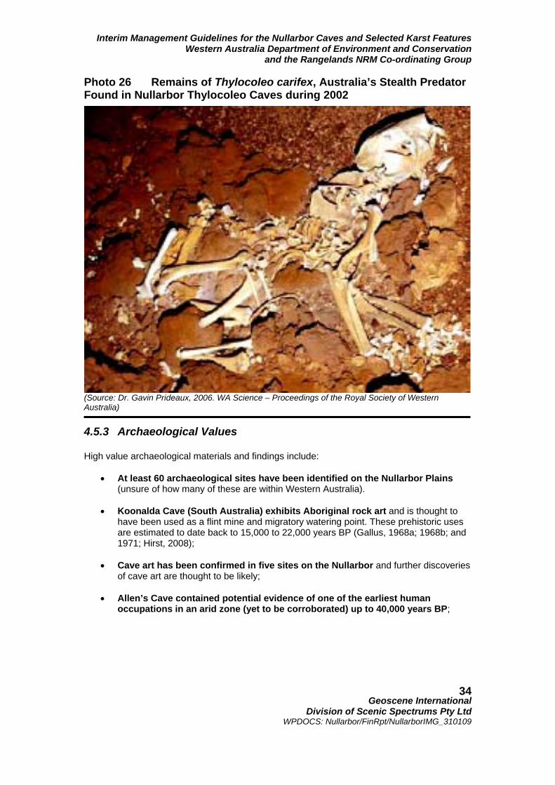
Interim Management Guidelines for the Nullarbor Caves and Selected Karst Features Western Australia Department of Environment and Conservation
and the Rangelands NRM Co-ordinating Group
Geoscene International
Division of Scenic Spectrums Pty Ltd WPDOCS: Nullarbor/FinRpt/NullarborIMG_310109
34
Photo 26 Remains of Thylocoleo carifex, Australia’s Stealth Predator Found in Nullarbor Thylocoleo Caves during 2002
(Source: Dr. Gavin Prideaux, 2006. WA Science – Proceedings of the Royal Society of Western Australia) 4.5.3 Archaeological Values High value archaeological materials and findings include:
• At least 60 archaeological sites have been identified on the Nullarbor Plains
(unsure of how many of these are within Western Australia).
• Koonalda Cave (South Australia) exhibits Aboriginal rock art and is thought to have been used as a flint mine and migratory watering point. These prehistoric uses are estimated to date back to 15,000 to 22,000 years BP (Gallus, 1968a; 1968b; and 1971; Hirst, 2008);
• Cave art has been confirmed in five sites on the Nullarbor and further discoveries
of cave art are thought to be likely;
• Allen’s Cave contained potential evidence of one of the earliest human occupations in an arid zone (yet to be corroborated) up to 40,000 years BP;

Interim Management Guidelines for the Nullarbor Caves and Selected Karst Features Western Australia Department of Environment and Conservation
and the Rangelands NRM Co-ordinating Group
Geoscene International
Division of Scenic Spectrums Pty Ltd WPDOCS: Nullarbor/FinRpt/NullarborIMG_310109
35
4.5.4 Surface Ecosystem, Flora and Fauna Values Surface ecosystems, flora and fauna of the Nullarbor are of high value and include:
• all Declared Rare, Vulnerable and Special Priority flora and fauna species within five IBRA biogeographical subregions);
• Ecosystems at risk; • Reserve Priority or Off-Reserve Conservation Species; • Centres of Endemism Refugia in several areas.
Wetlands of subregional significance include:
• Lake Boonderoo, • Hampton Scarp Rockholes, • Duck Pond (Arubiddy Station); • a Paleodrainage channel (on Gunnadorah Station); and • Lake Daringdell.
All high value flora species and taxa within the project area are listed in Appendix 5 and include the example Rare and Priority 1 species shown in Table 1. All high value fauna species and taxa within the project area are listed in Appendix 5 and include those Schedule 1 and Schedule example species shown in Table 2. Table 1 Rare and Priority 1 Flora Species in the Nullarbor Cave and Associated Karst Project Area (Source: DEC, 2003. 2002 Biodiversity Audit Database. Western Australia) Some of the Rare and Priority 1 flora species are depicted in Photos 27 – 30. Aside from the Schedule 1 fauna listed in Table 2, the Nullarbor is the western-most range of the Southern Hairy-nosed Wombat. Many of the caves also provide refuge and maternity shelters for the Chocolate Wattled Bat. These species are depicted in Photos 31 – 37.
Adenanthos eyrei R Conospermum toddii R Dampiera eriantha P1 Eremophila attenuata P1 Eremophila oblonga P1 Eremophila parvifolia subsp. auricampa P1 Eremophila perglandulosa P1 Eucalyptus merrickiae R Grevillea phillipsiana P1 Lepidium fasciculatum P1 Myoporum velutinum P1 Thysanotus baueri P1

Interim Management Guidelines for the Nullarbor Caves and Selected Karst Features Western Australia Department of Environment and Conservation
and the Rangelands NRM Co-ordinating Group
Geoscene International
Division of Scenic Spectrums Pty Ltd WPDOCS: Nullarbor/FinRpt/NullarborIMG_310109
36
Photos 27 – 30 Adenanthos eyrei, Stachystemon venosus, Lepidium fasciculatum, and Thysanotus baueri (Various Sources: florabase.dec.wa.gov.au/ browse/profile/1884 and other internet sites) Table 2 Examples of Schedule 1 and Other Priority Fauna Species in the Nullarbor Cave and Associated Karst Project Area
(Source: DEC, 2003. 2002 Biodiversity Audit Database. Western Australia) Photos 31 – 37. Southern Hairy-nosed Wombat, Chocolate Wattled Bat, Woylie, Malleefowl, Neretha Blue Bonnet and Peregrin Falcon (Various Sources: WA Museum, www.anbg.gov.au , www.tvwc.org , and other internet sources.)
Schedule 1 – Fauna that is rare or likely to become extinct Bettongia penicillata ogilbyi – Woylie* Dasycercus cristicauda – Crest-tailed Mulgara, Minyiminyi* Dasyurus geoffroii – Chuditch* Lagostrophus fasciatus fasciatus – Banded Hare-wallaby, Mernine Macrotis lagotis – Bilby, Dalgyte, Ninu* Notoryctes sp. – Marsupial Mole Sminthopsis psammophila – Sandhill Dunnart Leporillus conditor – Greater Stick-nest Rat, Wopilkara Leipoa ocellata - Malleefowl * species regarded as currently locally or regionally extinct Schedule 4 – Other specially protected fauna Cacatua leadbeateri – Major Mitchell’s Cockatoo Northiella haematogaster narethae – Naretha Blue Bonnet Falco peregrinus – Peregrine Falcon

Interim Management Guidelines for the Nullarbor Caves and Selected Karst Features Western Australia Department of Environment and Conservation
and the Rangelands NRM Co-ordinating Group
Geoscene International
Division of Scenic Spectrums Pty Ltd WPDOCS: Nullarbor/FinRpt/NullarborIMG_310109
37
4.5.5 Cultural Heritage Values
Indigenous cultural heritage places, sites and features are protected under the Aboriginal Heritage Act 1972 (WA) and may potentially include: habitation sites, seed grinding sites, habitation structures, middens, stone artifact factory sites, marked trees, burial sites, stone structures, paintings, engravings, caches, ceremonial grounds, etc; All information received regarding potential Aboriginal sites is placed on the Register of Aboriginal Sites by the DIA, including supporting evidence. In relation to caves, some example Registered Aboriginal Sites are located at Dingo Cave on Moonera Station; Wapet, Joe’s, Mullamullang, Spider Sink and Kestrel No. 2 caves and Parritappa Doline on Madura Station; Madura Cave on Madura Station; Snake Pit and Webbs caves on Mundrabilla Station; Weebubbie Cave, Weebubbie Road Blowhole, Chowilla Landslip, Abrakurrie, Winbirra, and Kangaroo caves; and Cocklebiddy Cave in Nuytsland Nature Reserve. Examples of non-indigenous cultural heritage places, sites and features these within the project area include: National Heritage Register sites (e.g., the Eucla Area, Nuytsland Nature Reserve, Old Telegraph Station at Balladonia) and State Heritage Register sites (e.g. Eucla Jetty, Old Eucla Telegraph Station, Eyre Telegraph Station, Mallee Tree, and Weebubbie Cave);
A list of known non-indigenous heritage sites is provided in Appendix 2. 4.5.6 Natural Heritage Places, Sites and Features
Site registers and listings include the former Commonwealth Register of National Estate, the National and Commonwealth Heritage Lists, the Western Australian Register of Heritage Places or the Western Australian Geo-heritage Register. Natural heritage places may also be listed under Municipal Inventories or recorded/classified by the National Trust of Australia (WA Branch). A list of known natural heritage sites is included with the non-indigenous cultural sites in Appendix 2.
4.5.7 Scenic Resources Scenic resources include the visual landscape and the human appreciation of scenic beauty of the Nullarbor caves and associated karst features of focus. CALM’s (1994) assessed the Nullarbor Plain Landscape Character Subtype as having moderate to high scenic quality (CALM, 1994). Some of the notable features are the variety of landforms in the area including the steep cliffs (e.g. Baxter Cliffs), flat caves entrances (e.g. Cocklebiddy Cave), abrupt appearance of an escarpment (e.g. Hampton Scarp) and the formation and height of wind formed dunes (e.g. Delisser Sand dunes, Eyre sand dunes). The vegetation also provides variety with pockets of taller vegetation in low lying areas that contrast with the surrounding adjacent low saltbush dominated plains.
Frame of reference assessment criteria for features of high or moderate scenic quality prepared by CALM (1994) are provided in Appendix 7.

Interim Management Guidelines for the Nullarbor Caves and Selected Karst Features Western Australia Department of Environment and Conservation
and the Rangelands NRM Co-ordinating Group
Geoscene International
Division of Scenic Spectrums Pty Ltd WPDOCS: Nullarbor/FinRpt/NullarborIMG_310109
38
4.5.8 Tourism, Recreation and Wilderness Values, Facilities and Activities
Recreation, tourism and wilderness values are clearly highly important values of the Nullarbor given its unique landscape features, its isolation and the popularity and notoriety of “crossing the Nullarbor” by travelers from throughout Australia and overseas. Tourism opportunities for the region noted by the (draft) Shire of Dundas Coastal Management Plan (South Coast Consulting, 2003) include:
o Landscape Features e.g. caves, cliffs, cave diving, underground lakes, fossils; o Flora and Fauna Experiences e.g. Eyre Bird Observatory, whale watching,
fishing; o Nullarbor Experiences e.g. outback camping, star gazing, camel trekking; o Historical Adventures e.g. visiting ruins, travelling the Telegraph Line, where Eyre
travelled, where Baxter was buried; o Festival Experiences e.g. Eucla Gold Day, Eucla Shoot; o Nullarbor Products e.g. local seafood, artwork; o Research Expeditions e.g. marine, caving, flora, fauna, geology.
The Eyre Bird Observatory (housed within the former Eyre Telegraph Station) annually runs environmental and educational courses, including bat banding in Murra El Elevyn Cave, Malleefowl surveys on the Roe Plain and other activities. Annual visitor numbers to the Nullarbor’s Conservation Estate were quite low during 2006-2007, ranging from 5,500 visitor days at Nuytsland Nature Reserve, to 1000 visitor days each for Eucla National Park and for Dundas Nature Reserve. Queen Victoria Spring Nature Reserve had an estimated 100 visitor days, while the Great Victoria Desert Nature Reserve had only 20 estimated visitor days. This data has been provided by DECs Recreation and Tourism Information System (RATIS) database. Wilderness values of the Nullarbor are very high, as indicated by Davey et al. (1992, p. 79). 4.5.9 Scientific Research and Education Values Davey et al. (1992) state scientific research and education values are high for the project area and for the Nullarbor Karst System in general. Scientific values of the planning area include (among many others):
o Geologic and geomorphic values o Speleological values o Hydrologic values o Botanical values (flora) o Zoological values (fauna) o Biodiversity values (flora and fauna) o Archaeological values o Anthropological values o Paleontological values;
Davey et al. (1992) also state that “the Nullarbor is regarded internationally as the classical area for the study of arid land karst processes”; “The Nullarbor Plain is a vast educational resource at all levels in that it demonstrates all aspects of the formation of karst landforms in an arid climate”.

Interim Management Guidelines for the Nullarbor Caves and Selected Karst Features Western Australia Department of Environment and Conservation
and the Rangelands NRM Co-ordinating Group
Geoscene International
Division of Scenic Spectrums Pty Ltd WPDOCS: Nullarbor/FinRpt/NullarborIMG_310109
39
The Nullarbor is also a highly valuable exploration destination, with explorations since the 1950s leading to a range of very important scientific discoveries and research opportunities. 5 Key Management Issues 5.1 Overview Given the combination of high environmental and cultural values and the mix of land tenure and management vestings there are a very wide range of management issues. Figure 7 provides an overview of this range of issues. In reviewing these issues, it is useful to recognise that the purpose of this report is to prepare Interim Management Guidelines for implementation over the next five years in order that essential field operations and management decisions can be carried out while a full management plan is in waiting. In addition, the focus is on the protection and management of the caves, dolines and blowholes and their immediate surrounds. What we are basically trying to do is take the first significant step towards some type of agreed, united on-ground management by a number of key stakeholders around the cave and karst areas that we believe are currently under potential existing threat. The IMG’s must contain recommendations that are acceptable, realistic and achievable. For this reason some issues identified in this overview will receive greater attention than others (particularly those that are already well covered by clearly legislated and implemented management policies, regulations and procedures). Maintenance and protection of the caves, dolines and blowholes (and where necessary recovery or rehabilitation), along with the associated surface ecosystems, flora and fauna are the central focus of the guidelines4. Minimisation and protection of the resources from either direct or indirect damage by cave visitation and usage (for recreational or research purposes) or by land use activities and other environmental factors should be the primary objective. As Figure 7 indicates, all resource uses occurring within the broad legislative and management framework (as described in Section 3) may potentially result in various impacts to the caves and their associated karst features and ecosystems. The management framework should provide management and planning policies and programs designed to monitor and protect the resource condition and use. The upper cells of Figure 7 show that the resources may potentially be damaged or degraded through:
• vegetation removal or damage; • groundwater diversions or depletion; • pollution or contamination; • erosion and sedimentation; • disease and infections, and • predators and competitors (plants or animals).
NOTE 4: For the sake of brevity, from here onward, the use of the term cave or caves should be taken to also include blowholes and dolines, unless otherwise inferred or specifically noted.)

Interim Management Guidelines for the Nullarbor Caves and Selected Karst Features Western Australia Department of Environment and Conservation
and the Rangelands NRM Co-ordinating Group
Geoscene International
Division of Scenic Spectrums Pty Ltd WPDOCS: Nullarbor/FinRpt/NullarborIMG_310109
40
Figure 7 Overview of Management Issues Regarding the Nullarbor Caves, Dolines, Blowholes and Associated Karst Areas

Interim Management Guidelines for the Nullarbor Caves and Selected Karst Features Western Australia Department of Environment and Conservation
and the Rangelands NRM Co-ordinating Group
Geoscene International
Division of Scenic Spectrums Pty Ltd WPDOCS: Nullarbor/FinRpt/NullarborIMG_310109
41
Photo 38 Dingos and Wild Dogs are Predators on the Nullarbor (Source: Exploring Australia, http://www.exploringaustralia.com.au/showplace.php?p=176) These forms of damage may arise through the various land uses of the area (e.g. tourism and recreation, pastoralism, mining, or Indigenous uses) or through environmental factors or events (e.g. pest plants and animals or wildfire). Aside from reliance on statutory laws and regulations, managers may also modify or control the potential land uses and impacts through a combination of:
• establishment of Conservation Reserves; • co-operative management and agreements (with freehold and leasehold
landholders); • lease and licensing conditions (as applied to pastoral leases); • Native Title agreements, or • other management actions and operations.
The lower cells of Figure 7 show that the resources may potentially be damaged or degraded through:
• soil or surface cover compaction (or trampling); • breakage (primarily relating to speleothems or other internal cave features); • removal of speleothems, fossils, fauna, flora, etc.; or • contamination (e.g., chemical pollution, bacterial/fungal/virus invasions).
These impacts may potentially arise through recreational and tourism uses, cave rescue and safety training, research and exploration or various Indigenous uses. Such land uses and impacts may be modified or controlled through a combination of:
• controls/limitations on public knowledge of the location of the cave and karst features;
• controls/limitations on physical access to the cave and karst sites (e.g. by not providing or restricting vehicular and other forms of access);
• user permit and licensing procedures; and • education and training (i.e., regarding cave and karst values, vulnerability and how
to visit or use the resources in an environmentally sensitive and sustainable manner).
5.2 Key Issue Areas Addressing all of the various issues raised by the flow chart in Figure 7 would certainly require a full management plan. For the purposes of the IMGs, it is suggested that the following are

Interim Management Guidelines for the Nullarbor Caves and Selected Karst Features Western Australia Department of Environment and Conservation
and the Rangelands NRM Co-ordinating Group
Geoscene International
Division of Scenic Spectrums Pty Ltd WPDOCS: Nullarbor/FinRpt/NullarborIMG_310109
42
the key issue areas to be addressed for the interim period of management: (roughly in order of priority, but not absolutely so):
1. the use of caves and potential impacts on caves associated with:
• recreation & tourism uses; • research & exploration uses; and • rescue & safety training uses;
2. ecosystem, flora and fauna issues 3. pastoral uses and potential impacts on caves;
4. mining uses and potential impacts on caves; 5. transport and communications infrastructure and associated impacts on caves; 6. issues related to indigenous cultural heritage and aboriginal recognition and co-
operation; 7. fire control and management; 8. safety and liability issues; and 9. consideration of enhanced management frameworks.
Each of these key issue areas involve a number of specific issues that may require IMGs, taking in several of the other considerations raised in Figure 7. These will be discussed further below. Several other uses with potential impacts are relatively well-addressed by existing regulations, guidelines and practices. Indigenous use of the area is relatively low-profile. Protocols are in place for co-operative Aboriginal access and management under current land tenure arrangements. Until current Native Title claims are resolved, it is difficult to add to the guidelines and agreed arrange-ments already in place. Wildfire or bushfire regulations and response guidelines are also in place. Wildfires occurrence is not often on the Nullarbor, but given the remoteness of the area and the low population, wildfires often go unchecked until they burn out naturally. However, DEC has an increasing presence at selected wildfires on the Southern Nullarbor. In a similar fashion to wildfires, pest plant and animal controls are generally in place, along with protective measures for flora and fauna species declared under the EPBC Act, the Conservation and Land Management Act 1984 or the Wildlife Conservation Act 1950. New road and railway construction in the region is minimal, with most issues related to repairs and maintenance. Most of the issues are relatively site specific and would be handled through existing regulations and environmental management requirements of Main Roads, the railway authority and their contractors. Many existing management guidelines and regulations are in place regarding pastoral and mining uses. However, specific aspects of these should be reviewed in light of the focus issues of this report and recent adjustments to tenure and reserve allocations. The issues addressed will consider options regarding the range of land use and impact modifiers noted in Figure 7, including the application where appropriate of: Conservation Reserves; co-operative

Interim Management Guidelines for the Nullarbor Caves and Selected Karst Features Western Australia Department of Environment and Conservation
and the Rangelands NRM Co-ordinating Group
Geoscene International
Division of Scenic Spectrums Pty Ltd WPDOCS: Nullarbor/FinRpt/NullarborIMG_310109
43
management and agreements; lease and licensing conditions, and management actions and operations. 5.3 Ecosystem, Flora and Fauna Issues The surface and subterranean ecosystem, flora and fauna values and significance have been summarised in Sections 4.4.2, 4.4.3 and 4.5.4, with further detail in Appendix 4. Re-examination of these issues and provision of new interim guidelines for these issues is not within the scope of this report. However, some awareness of the recommendations put forward by McKenzie and Robinson (1987) and Subterranean Ecology (2007) should be acknowledged and not overlooked. 5.3.1 Surface Ecosystem Recommendations by the 2002 Biodiversity
Audit and by McKenzie and Robinson (1987) Recommendations regarding surface ecosystems, flora and fauna by the 2002 Biodiversity Audit (Dept. of Conservation and Land Management, 2003) and previously by McKenzie and Robinson (Eds., 1987) are quite detailed should be referred to within the original reports. As indicated in Section 4.5.4, these recommendations focus on the protection of declared flora and fauna under the EPBA Act 1999, ecosystems at risk, reserve priority or off-reserve conservation species, centres of endemism refugia and wetlands of subregional significance. 5.3.2 Subterranean Ecology’s Recommended Conservation and
Research Priorities Subterranean Ecology (2007, pp 68- 70) cite the additions to the reserve system recommended in McKenzie and Robinson (Eds. 1987), indicating that although those additions were based on surface ecological values only, that they also encompass a substantial number of significant caves and karst features and should be implemented as soon as possible. Reserves for the coastal strip between Cocklebiddy and Madura, and Mundrabilla to Eucla are especially recommended by Subterranean Ecology. The development of interim management guidelines that address the identified threats and potential impacts to cave fauna and their habitats is also recommended, with a focus on the protection of sensitive habitats and species at the regional and site specific (individual cave) levels. This will require practical education and awareness/training programs, including signage, gating and permits, at specific caves, along with effective monitoring and review. Microbial mantles, although not greatly reviewed in its desktop study, are recommended by Subterranean Ecology for high priority protection within underwater sections of caves. No-go zones may be required near significant microbial mantles and possibly signage and education programs for cave diving training associations. It is recommended that microbial mantles, especially those in Weebubbie Cave, should be considered for nomination as a Threatened Ecological Community under the EPBC Act. (Refer to further information on microbial mantles in Section 4.4.2.) Future research should address the lack of taxonomic descriptions of much of the invertebrate subterranean fauna. Troglobitic and stygobitic taxa are particularly cited for attention, along with key taxa indicative of general biodiversity patterns or representative of ecological community types (e.g. guano, tree root and aquatic communities) that may facilitate conservation planning and management. Key invertebrate taxa include:
• Tartarus spp. • Janusia spp. • Trogloblattella • Protochelifer ‘cavernarum’ • Stygobitic taxa from the Roe Plain

Interim Management Guidelines for the Nullarbor Caves and Selected Karst Features Western Australia Department of Environment and Conservation
and the Rangelands NRM Co-ordinating Group
Geoscene International
Division of Scenic Spectrums Pty Ltd WPDOCS: Nullarbor/FinRpt/NullarborIMG_310109
44
Further research on the distribution, restriction and/or endemism of key troglobitic genera are also required and would probably result in the identification of new species as well. The use of DNA and other molecular markers is recommended for future phylogeography studies of troglobitic and stygobitic taxa, which investigate the evolutionary relationships between taxa. In combination with the above research, targeted surveys of caves are needed to identify those likely to have important biological values, especially where current knowledge gaps exist and potential threats exist. A focus on many of the smaller and less visited caves (e.g., Fern Cave, Webbs Cave, Prostrate Pit, etc.) is called for to redress some of the current sampling imbalances and to provide a more realistic assessment of invertebrate diversity, hotspots and biological significance. Key vertebrate taxa for research are the bat species, which require additional knowledge and data for the estimation of populations, breeding and birthing periods, inter-cave movements, and to determine seasonal migration or annual/seasonal changes in populations. Research into the food source issues of bat guano for guano invertebrate communities is also noted as important. Subterranean Ecology (2007, p. 70) summarise their conservation and research priorities as: “Proceed with existing reserve proposals.
1. Investigate new reserve proposals or other conservation measures required for
important fauna caves identified in this study; 2. Develop interim management guidelines and works programs that address he
identified threats and potential impacts to cave fauna; 3. Address the gaps in taxonomic knowledge for key troglobitic/stygobitic taxa using
combined morphological and molecular approach; 4. Address the knowledge gaps on cave-dwelling bats on the Nullarbor, to identify
important caves and conservation priorities; 5. Undertake a targeted survey of caves and mesocavern habitats which are likely to
have important biological values, especially in areas where knowledge gaps exist and potential threats may be prevalent. Survey to address gaps in taxonomic coverage (e.g. micro-fauna such as Acarina, Collembola, Psocoptera), habitat coverage (e.g. aquatic, mesocaverns) and areal coverage (e.g. Roe Plain and other sub-regions);
6. Nomination of the microbial mantles in Weebubbie Cave (and possibly other caves)
as a Threatened Ecological Community under the EPBC Act. 5.4 Use of Caves for Recreational, Research and Other Activities 5.4.1 Cave Fragility and Past Damage Nicholas White (2001) and Professor Elery Hamilton-Smith (2006) underscore the overall fragility and vulnerability of karst systems, particularly the Nullarbor Karst System due to it being what is considered to be an ”arid” karst system (i.e. less than 250 mm annual rainfall – Zone III). Hamilton-Smith goes on to state that: “A change in any of the major components of the system will inevitably impact upon others. Given that water is the most basic yet most variable of the major components, it is the one most likely to be subject to either changes in volume or to pollution of various kinds. Thus, it is also the most important element in almost any protective management program.

Interim Management Guidelines for the Nullarbor Caves and Selected Karst Features Western Australia Department of Environment and Conservation
and the Rangelands NRM Co-ordinating Group
Geoscene International
Division of Scenic Spectrums Pty Ltd WPDOCS: Nullarbor/FinRpt/NullarborIMG_310109
45
Hamilton-Smith (Pers. Com., May-June, 2008) has related some specific episodes in which Australians with good knowledge of the caves have removed fossils and other items from the caves for surreptitious sale on the Australian black market or to unwitting international collectors. Fortunately, the cases mentioned were foiled by Hamilton-Smith and other alert speleologists relatively early on. However, with the advent of the internet, such unethical and illegal movement of fossils and speleothems from the Nullarbor caves is a significant risk. Davey et al. (1992, p. 83) point out that the Nullarbor caves have energy-poor ecosystems due to the arid surface conditions and the low inputs of organic materials and faeces. As such, the cave fauna may be diverse but not abundant and is vulnerable to disturbances that might reduce whatever energy source that exist. Disturbances by humans, including excess visitor numbers and destructive or unthinking caving activities often result in undesirable and long-lasting damage. “The local disappearance of Tartarus mulla mulla genensis from the Dome Chamber of Mullamullang Cave N37seems directly attributable to disturbance. Some important caves are close to roads or settlements and so are frequently visited by locals, tourists and cavers. The modification of Nurina Cave N46 and environs near Madura over only the past 14 years is an example. This cave, a benchmark for troglobitic diversity, suffers doline degradation from fossil digging activities (with potential detriment to cave water quality), as well as probable disturbance due to excessive caving activity. Another likely pressure upon cave ecosystems is the degradation of surface vegetation and soil that has resulted from past pastoral activities and the prevalence of rabbits. When this has occurred within cave catchment areas energy input into the cave system may be significantly reduced and entrance area erosion and siltation increased,” (Davey et al. 1992, p. 83). No doubt, many other examples of such disturbances exist. Many of the speleothems, especially those such as the gypsum flowers or the micro-halite speleothems are extremely fragile and can be destroyed with the softest of touches. The “coffee and cream” deposits in Mullamullang Cave have been very disturbed over the years (Davey, et al., 1992, p. 53). Microbial mantles are also extremely vulnerable to destruction, whether they occur in the open air or underwater, as they do occasionally. Rauleigh Webb, a long-time ASF and ACKMA member, has indicated that to avoid causing damage to the caves, he has simply quit going into them. However, the mystery and attraction of the Nullarbor Caves is so great that there would not be many cave adventurers, researchers or perhaps even current Aboriginal people with a “connection to country” who would totally resist entry. 5.4.2 Types and Level of Use Caves, blowholes and dolines are accessed by members of the general public who may live on the Nullarbor or who may be travelling through as tourists. They are also used by recreational caving, cave diving, speleological and bird observers groups. The speleological and bird observing groups may also be associated with various forms of exploration and research, officially or unofficially. Joining them in the areas of research are paleontologists, archaeologists, geologists and a range of other researchers who are officially affiliated with university or government research institutes or special projects. The speleologists, dry cavers and cave divers appear to use the caves more often than others. Some of the key organisations with an active interest in the Nullarbor whose members make more frequent cave visits and explorations include:
• ASF (Australian Speleological Federation) • CEGSA (Cave Exploration Group of South Australia) • WASG (Western Australian Speleological Group) • SRGWA (Speleological Research Group WA) • CDAA (Cave Divers Association of Australia)

Interim Management Guidelines for the Nullarbor Caves and Selected Karst Features Western Australia Department of Environment and Conservation
and the Rangelands NRM Co-ordinating Group
Geoscene International
Division of Scenic Spectrums Pty Ltd WPDOCS: Nullarbor/FinRpt/NullarborIMG_310109
46
• ACKMA (Australian Cave and Karst Management Association – to a lesser degree). Occasional trips to the Nullarbor Caves are also made by speleological, caving and cave diving organisations from the eastern states. An example of this is the National University Caving Club (NUCC) based at Australia National University who seem to make an annual visit to the Nullarbor caves. The Royal Australian Ornithologists Union (RAOU) and other bird observer groups also use the area. The Eyre Bird Observatory (housed within the former Eyre Telegraph Station) annually runs environmental and educational courses, including bat banding in Murra El Elevyn Cave, Malleefowl surveys on the Roe Plain and other activities. Two volunteer resident wardens located at Eyre serve as DEC’s eyes and ears for that part of the Nuytsland Nature Reserve. Davey et al. (1992, p. 94) have stated that the caves offer little attraction to vertical cavers since none of the caves offer the thrill of rope descents into bottomless pits. However, photographs of NUCC’s activities during December 2007 clearly show that collapsed dolines with overhangs above cave entrances are used for abseiling purposes (refer to Photo 41). The exact level of use is difficult to determine. The relative number of annual visitor days accounted for by DEC (RATIS) is about 5,500 in Nuytsland Nature Reserve altogether, which would include non-cave visits as well as people who may camp or stay in the area for multiple days. Elsewhere, Eucla National Park only receives about 1000 visitor days, as does Dundas Nature Reserve. However, it is cautioned that these are only estimates and DEC has no staff in the area to make regular observations or to account for visitor numbers in any way. Pastoral leaseholders do not keep any records of visitors accessing caves on their stations. Discussions with two pastoralists indicate that they only receive one or two groups per year, aside from the organised caving clubs who tend to call ahead (Pers. Com. with Bree Campbell and Peter Brown AM, June 2008). Occasionally they will find a group on their stations for a day-visit or camped overnight that have not sought permission or a permit. These groups are usually invited to move on. Some Pastoralists charge groups a nominal fee for day-use or overnight camping (e.g., $10/person/night) on their leasehold properties. However, most pastoralists are not overly interested in running or supervising tourism and recreational activities as it takes too much time away from the operations of the properties and from their own personal time. Over the years, Weebubbie Cave has probably been one of the most visited caves by the general public and tourists, often being directed there using information gained from websites or roadhouses along the Eyre Highway. Weebubbie has also been popular among the dry caving and speleological groups, along with a number of other caves. Cocklebiddy Cave is perhaps the most popular destination for cave divers, but they also use other caves with underground lakes. Other sites often visited include Nurina, Kestral No. 1, Murra-El-Elevyn Mullamullang and Old Homestead caves.

Interim Management Guidelines for the Nullarbor Caves and Selected Karst Features Western Australia Department of Environment and Conservation
and the Rangelands NRM Co-ordinating Group
Geoscene International
Division of Scenic Spectrums Pty Ltd WPDOCS: Nullarbor/FinRpt/NullarborIMG_310109
47
Photo 39 Abseiling on Collapsed Doline at Kestral No. 1 Cave
(Source: Olaf Theden, 2007. Copyright – used with permission.) Photo 40 Caving Group Camped near Mullamullang Cave
on Madura Station
(Source: Chris Bradley, 2007. Copyright – used with permission.)

Interim Management Guidelines for the Nullarbor Caves and Selected Karst Features Western Australia Department of Environment and Conservation
and the Rangelands NRM Co-ordinating Group
Geoscene International
Division of Scenic Spectrums Pty Ltd WPDOCS: Nullarbor/FinRpt/NullarborIMG_310109
48
5.4.3 Cave Access Permit System Currently Applied in the Nullarbor The DEC Cave Access Permit System is currently applied only to caves on DEC managed conservation estate in the Nullarbor. For the smaller reserves isolated within pastoral leasehold properties and not vested in DEC for management, DEC proposes to contact the Pastoralists for their permission to allow members of the public to access these areas via their station properties, as such visits can be disruptive, may lead to stock gates being left open or occur at times when the doggers (wild dog shooters), commercial kangaroo shooters or livestock musterers are working in the area. For other caves on pastoral leasehold properties or on Unallocated Crown Land, the regulations call for visitors to apply to the Department of Planning and Infrastructure for permission to access these areas. DPI apparently issues a letter of permission which is also copied to the local Police Department. It is uncertain how many caving groups are aware of this requirement and based on anecdotal information, there appears to be little record keeping of permission letters issued by DPI. There is also apparently no cross-reference communication between DEC and DPI regarding cave access permits issued or letters of permission sent out. Some groups, particularly the cave diving members of CDAA, have co-operated with DEC in the application of a Cave Access Permit System (discussed further below) over the past 15-20 years. Dry cavers have not tended to seek permits as readily from DEC for cave access. Short term visitors (i.e., the passing general public) also did not tend to apply for permits to enter caves previously (i.e., prior to Cocklebiddy Cave being closed to the general public). Records from that system kept by the DEC Esperance District Office for Nuytsland Nature Reserve provide numbers of groups and individuals provided with permits to access three caves (Cocklebiddy, Murra El Elevyn and Tommy Graham’s caves) within the reserve over the last 15 years. Each of the three caves has had permits granted for 103 to 111 groups over that time period, with Cocklebiddy being slightly more popular than the other two caves. Due presumably to the time and effort it takes to get to the Nullarbor, in the majority of cases such groups tend to explore and or dive in Cocklebiddy, Murra El Elevyn and Tommy Grahams Caves at some time during the duration of their groups visit to this area. As all of these three caves contain water bodies this might account for the compliance of CDAA cave diving members. However the fact that CDAA members are made aware of the permit system requirements via that organisation’s monthly newsletter, called Guidelines is the more likely explanation. Pannikin Plains Cave has remained closed since late 1998 as a result of a thunderstorm event which according to advice from a Geotechnical Engineer has potentially made sections of this cave unstable. In the past, some of the university clubs had provided visitor books to be signed at some caves (e.g. Tommy Grahams and Abrakurrie Caves). However, these visitor books have been removed and no longer provide any record of who is entering the caves or when. There are obviously technical policy and administration issues to be resolved regarding the various vestings, authority and cooperative administration regarding the issuance of cave access permits or letters of permission for various land tenure categories on the Nullarbor. DEC, DPI and potentially the PLB may need to be involved in the resolution of this issue. DPI also issues permits to cave divers adding further complexity to the procedures and record-keeping. Table 3 provides examples of different caves in relation to their locations on pastoral leases or on the DEC managed estate.

Interim Management Guidelines for the Nullarbor Caves and Selected Karst Features Western Australia Department of Environment and Conservation
and the Rangelands NRM Co-ordinating Group
Geoscene International
Division of Scenic Spectrums Pty Ltd WPDOCS: Nullarbor/FinRpt/NullarborIMG_310109
49
Table 3 Selected Caves in Relation to Pastoral Stations and the DEC Managed Estate by Biodiversity Ranking and Location Cave's Located on Nullarbor Pastoral Stations Cave Name Biodv. Rank Station Gates as Noted Mullamullang # 2 Madura Thampanna # 4 Mundrabilla Unnnamed (1327) 6 Madura Cave is gated Madura # 12 Madura Fern 18 Mundrabilla Dingo Donga 20 Madura Thylacine 23 Madura Joes 24 Madura Sentinel 25 Madura Stegamite 26 Exact location unknown Roaches Rest # 27 Madura Webbs # 28 Mundrabilla Erosion 29 Exact location unknown Purple Goringe 30 Exact location unknown # To be included in DEC conservation estate as part of the 2015 pastoral lease review agreement. Caves located on Nullarbor DEC managed estate (all within Nuytsland NR) Cocklebiddy 3 Pannikin Plains 7 Murra El Elevyn 12 Caves located on Unallocated Crown Land Old Homestead 1 Nurina 5
Weebubbie 8 Within unvested Water Reserve
Burnabbie 9 Unnamed (327) 10 Cave is gated Abrakurrie 13
(Source: DEC, June 2008) Other specific procedures for administration, control and monitoring of cave access permits and visits may be available for consideration, but are not currently employed. One such Cave Permit System is TRIPMan – cave permit software developed and documented by Webb (2005). Further investigation by DEC is warranted.

Interim Management Guidelines for the Nullarbor Caves and Selected Karst Features Western Australia Department of Environment and Conservation
and the Rangelands NRM Co-ordinating Group
Geoscene International
Division of Scenic Spectrums Pty Ltd WPDOCS: Nullarbor/FinRpt/NullarborIMG_310109
50
5.4.4 DEC Cave Regulations and Policies The DECs Conservation and Land Management Regulations 2002 (CLMR 2002) include regulations that are relevant to cave management in Western Australia. Regulation 29 prohibits the smoking of cigarettes, cigars or pipes in any cave or any part of a cave on DEC- managed land (with penalties of $500 and $2000 respectively). Regulation 31 seeks to prevent and provide disincentives to the damage or removal of naturally occurring features, including fossils, mineral specimens, stalactites and stalagmites (with penalties of $2000 for removal or for refusal to surrender a feature upon direction to do so). Regulation 49 allows the CEO (or an authorised staff member) to grant permits for cave entry under conditions to be specified for approved calendar dates. It also states that “A person must not, without lawful authority, enter or remain in a cave (Penalty: $1000)” and that “A person in a cave must comply with the conditions and restrictions subject to which that person was given permission to be in the cave (Penalty: $1000)”. Regulation 49 states that”Nothing in this regulation prohibits persons entering or remaining in a cave under the control of a person licensed under a commercial operations license to take those persons into the cave.” The above regulations are cited by the DEC’s Recreation Policy No. 18 (Sections 2.4 and 2.5 – refer to Box Text on pages 51 - 53). This policy recognises the care and protection required by caves in Western Australia. The policy is in cooperation with the Caves Management Advisory Committee (CMAC), which provides advice on issues relating to Leeuwin Naturaliste National Park. This policy also acknowledges the Australian Speleological Federation Inc. (ASF) and its Western Australian member bodies (WASG, ACKMA and CMAC) as the main sources of expertise on cave management in Western Australia. The IUCN Guidelines for Cave and Karst Protection (Watson et al., Eds., 1997) are also cited in the policy as a key source to be consulted. Policy No. 18 provides general directions as to DEC’s management and the public’s recreational use of caves, a cave management classification system, 12 policy guidelines and a DEC caving and cave diving codes of practice. The guidelines and the codes of practice are contained in the boxes following. The Cave Management Classification System (2006) was developed for the application of Policy 18 (refer to Table 4.) Although CLMR 2002 does not cite them, Regulation 41 and Regulation 42 of CLMR 2002 may also have relevance to caves. Regulation 41 states that a person must not enter any land or waters classified as a prohibited area, a temporary control area or a plant disease management area (as classified under section 62) without lawful authority, with a penalty of $2000 for violation.
(text continues on p. 56)

Interim Management Guidelines for the Nullarbor Caves and Selected Karst Features Western Australia Department of Environment and Conservation
and the Rangelands NRM Co-ordinating Group
Geoscene International
Division of Scenic Spectrums Pty Ltd WPDOCS: Nullarbor/FinRpt/NullarborIMG_310109
51
DEC Recreation Policy 18 Cave Policy Guidelines 2.4.1 DEC will, in close liaison with the Australian Speleological Federation Inc. (ASF) and other
speleologists, develop and maintain a confidential and up to date inventory of all caves and major karst features on lands that it manages.
2.4.2 All known caves on lands managed by DEC will be assessed according to the cave
management classification system as outlined in Table 3.
• All caves should be considered “Restricted Access’ until an assessment has been made of the cave’s values and level of risk.
• Where appropriate, caves that have already been damaged by visitation should be selected as Tourist and Adventure Caves.
2.4.3. The preparation of management plans and/or programs for individual caves will be
undertaken as time and resources permit. 2.4.4 Care will be taken to ensure that surface land management by DEC does not adversely
impact on cave features or their management. Where their water catchment areas extend beyond the boundaries of DEC managed land, efforts will be made to encourage similar sensitivity by other land managers.
2.4.5 Where appropriate, visitor fees to tourist caves will be charged in accordance with Schedule
1 Division 7 of the Conservation and Land Management Regulations 2002 and permit fees will be charged in accordance with Schedule 1 Division 8 of the Conservation and Land Management Regulations 2002.
2.4.6 Where practical, the use of Adventure Caves will be carefully controlled and monitored
through development of an entry permit system and/or self-registration stations. Where necessary, DEC may close or otherwise restrict/limit public use where such use is resulting in unacceptable damage to caves, cave features or decorations, or cave flora and fauna.
2.4.7 Because cave features and decorations are easily damaged by uncontrolled access and
use, cave locations will not be divulged on DEC maps and publications with the exception of Tourist Caves and Adventure Caves – Class One caves. Where possible, DEC will discourage the disclosure of this information in maps and publications produced by other agencies/organisations.
2.4.8 DEC will alert speleologists and other visitors to the potential hazards within public access
caves situated on lands that it manages through the use of signs and other means of communication. Similar strategies will apply to restricted access caves in some cases.
2.4.9 DEC will recognise that the best natural protection for caves and karst is an increase in the
awareness of individual visitors of the natural values of caves and the need for careful use, protection and management. This will be encouraged by the use of signs and other means of communication and the education of cave leaders.
2.4.10 Caves classified as ‘Restricted Access’ will not be available as a concession, but access to
other caves may be managed by way of a lease or license, subject to conditions specified in section 1.15.

Interim Management Guidelines for the Nullarbor Caves and Selected Karst Features Western Australia Department of Environment and Conservation
and the Rangelands NRM Co-ordinating Group
Geoscene International
Division of Scenic Spectrums Pty Ltd WPDOCS: Nullarbor/FinRpt/NullarborIMG_310109
52
DEC Recreation Policy 18 Cave Policy Guidelines….continued 2.4.11 A cave may be gated and locked (temporarily or permanently) once the following criteria
have been considered:
• There is no practical alternative to preventing damage to the cave features/decorations, flora, fauna, or the cave itself.
• There is no practical alternative to protecting significant decoration, scientific work undertaken, rehabilitation or protecting the general public from a particularly dangerous area.
• It is practical to do so without damaging the cave. • It is practical to do so without disturbing wildlife (e.g. bats), airflows and/or water flows. • It is not contrary to any existing management plans.
2.4.12 Access to and use of caves by all persons including DEC personnel will be provided in
accordance with DEC’s Code of Practice (following), which has adopted parts of the Australian Speleological Federation (ASF) Code of Ethics and Conservation and the ASF Minimal Impact Caving Code (refer www.caves.org.au). DEC also provides cave leadership training under its ‘Cave Leadership Course”.
DEC’s Code of Practice establishes a minimum standard of caving practice. If higher
standards are required by DEC at a particular cave, they will be signposted accordingly (e.g. cavers entering restricted access caves should abide by the ASF Minimal Impact Caving Code).
DEC Recreation Policy 18 Cave Diving Policy Guidelines 2.5.1 DEC recognises cave diving as a legitimate scientific and recreational activity on lands that
it manages. 2.5.2 DEC will maintain liaison with the ASF, the CDAA and representative cave divers with
regard to access requirements and management for caves on lands that it manages. 2.5.3 DEC will maintain strict permit entry control to cave divers. Permits may require the
submission to DEC of trip reports (including any maps produced) for archival/monitoring purposes, detailing any scientific evaluations or information obtained.
2.5.4 The microbial mantles of the Nullarbor caves will be protected by the permit system, the
designation of ‘no-go’ areas and diver education. 2.5.5 The ASF Code of Ethics and Conservation, the ASF Minimal Impact Caving Code and the
ASF Cave Diving Code of Practice (refer www.caves.org.au) will apply to all sections of caves used for cave diving. Details on Australian National Competencies for Caving and Diving are available from the National Training Information Service (refer www.ntis.gov.au, search SR003 Outdoor Recreation Industry, caving.

Interim Management Guidelines for the Nullarbor Caves and Selected Karst Features Western Australia Department of Environment and Conservation
and the Rangelands NRM Co-ordinating Group
Geoscene International
Division of Scenic Spectrums Pty Ltd WPDOCS: Nullarbor/FinRpt/NullarborIMG_310109
53
DEC’s Caving Code of Practice Towards Management Authorities and the General Public 1. Where required, cave visitors must have specific permit approval before entering any cave.
They will enter only caves authorized by the relevant permit and at the permit specified times. All permit or other entry conditions must be complied with.
2. The prevailing procedures regarding nearby camping areas will be followed and care taken
to prevent damage to signs, equipment, wildlife or landscape features. 3. All cave visitors will be as self-sufficient as possible in terms of water, supplies, assistance
required, etc. Towards caves and karst 1. Caving activity must be conducted in a manner responsible to the cave environment, taking
particular care to avoid damage to speleothems, sediments, biota and other natural phenomena. The maximum and minimum size of any party will be limited to that authorized by the relevant permit.
2. Cave entrances and passages should not be excavated/enlarged, water levels in sumps
should not be modified and stream flows should not be diverted without prior consent of DEC.
3. Established marked routes must be used: single tracks should be followed and care taken to
avoid needless deposition of mud. Mud throwing or modelling is unacceptable. 4. All human introduced wastes must be removed from the cave and disposed of properly. 5. Cave visitors will not light fires or smoke in any cave. 6. Caves must not be disfigured by unnecessary marking (including direction arrows). 7. Disturbance should not be caused to any biotic community. No disturbance should be
caused to maternity or over wintering roosts of bats. Sampling of wildlife (dead or living), palaeontologic material, or archaeological material will not occur without special permit approval.
8. All cave visitors will carry at least one light source (but preferably two or more sources) and
wear a “fasten-on” head helmet where practicable when in a cave. Light sources should be adequate for the planned duration of any particular trip. Trip Leaders are responsible for the gear worn by each member of his/her group.
9. No person will be coerced to go underground/through squeezes, etc. 10. When underground, no trip member will be deprived of any light source (except to aid in
emergency). 11. Policy guidelines for recreational abseiling (see Section 23) must be followed in caves and
karst features such as dolines that may attract recreational abseiling outside of essential cave access and exploration requirements.

Interim Management Guidelines for the Nullarbor Caves and Selected Karst Features Western Australia Department of Environment and Conservation
and the Rangelands NRM Co-ordinating Group
Geoscene International
Division of Scenic Spectrums Pty Ltd WPDOCS: Nullarbor/FinRpt/NullarborIMG_310109
54
Table 4 DEC Cave Management Classification System (2006)
TOURIST CAVE (Guided or self-guided e.g. Crystal Cave, Yanchep National Park (YNP); Calgardup Cave, Leeuwin Naturaliste National Park (LNNP)
General public. • Developed and managed for tourist use and/or as an educational resource
• Clearly signposted with access restricted to specific times.
• Payment of a fee required for entry.
• Infrastructure installed to facilitate access, decrease visitor impacts and improve safety.
ADVENTURE CAVE – Class 1 e.g. Tunnel Creek, Kimberley
General public. • May be required to register at the cave entrance and/or pay a fee.
• May be some infrastructure and signage to decrease visitor impacts and improve safety.
PUBLIC ACCESS
ADVENTURE CAVE – CLASS 2 (horizontal) e.g. Golgotha Cave, Calgardup Window Extension (LNNP), Yonderup Cave, Mambibby Cave (YNP) - Class 3 (Vertical) e.g. Mill Cave (LNNP)
Novice groups (general public) led by an experienced leader, e.g. school groups and licensed commercial tour operators. Speleologists.
• General protection • Entry permit needed • DEC approved leader
needed • May be limited
infrastructure.
RESTRICTED ACCESS
RESTRICTED ACCESS Note: All caves are in this category unless designated otherwise. (Refer to section 2.4.2)
Experienced and responsible speleologists and scientists.
• Maximum protection • Entry permit needed • DEC approved leader
needed • Speleological club visits • Research monitoring or
management purposes.
(Source: Dept. of Environment and Conservation, Recreation Policy 18 Cave Policy Guidelines)

Interim Management Guidelines for the Nullarbor Caves and Selected Karst Features Western Australia Department of Environment and Conservation
and the Rangelands NRM Co-ordinating Group
Geoscene International
Division of Scenic Spectrums Pty Ltd WPDOCS: Nullarbor/FinRpt/NullarborIMG_310109
55
Photo 41 Divers in Underwater Passage of Cocklebiddy Cave
(Source: D. Riordan, 2007. Photo in article by Tania Yarra in Quest, Vol. 8, No. 1 Winter. ) Photo 42 Gear Readied for Lowering into Cocklebiddy Cave during
a Recent Diving Expedition
(Source: C. Ross, 2007. Photo in article by Tania Yarra in Quest, Vol. 8, No. 1 Winter. )

Interim Management Guidelines for the Nullarbor Caves and Selected Karst Features Western Australia Department of Environment and Conservation
and the Rangelands NRM Co-ordinating Group
Geoscene International
Division of Scenic Spectrums Pty Ltd WPDOCS: Nullarbor/FinRpt/NullarborIMG_310109
56
Regulation 42 states that a person must not enter “otherwise than on foot or by vessel” any land classified under section 62 as a ”limited access area” or under section12A of the Wildlife Conservation Act 1950 as “a limited access area where that classification remains in force”, with a penalty of $2000 for violation. 5.4.5 Potential Application and Limitations of Existing Cave
Regulations and Management Systems DEC’s Recreation Policy 18 and the Cave Access Committee were established in reference to caves within Leeuwin Naturaliste National Park. They may provide a model for adaption to caves in the Nullarbor region. CLMR 2002 clearly gives the CEO of DEC authority to issue permits and charge permit fees for access to any caves in Western Australia, including those on the Nullarbor. Regulation 41 provides DEC with the authority to restrict access into areas declared as “prohibited areas”. However, it is doubtful that Regulation 42 could be used to restrict access into caves on the Nullarbor, since all such access would have to be “on foot”. The role of the Caves Access Committee (CAC) was established by speleological groups to work in cooperation with DEC or other authorities in relation to caves of Western Australia. CAC’s structure may be suitable to represent speleological groups interested in Nullarbor cave access. However, it does not appear to embrace the Cave Divers Association of Australia or other cave recreation or research groups. There also appears to be no stated Memorandum-of-Agreement or other agreement established between CAC and DEC in relation to the Nullarbor caves. Differences seem to exist in the DEC training requirements for “dry cavers” and “cave divers” in their separate policy guidelines for the two groups. The requirements for who must attend the ‘Cave Leadership Course” and who must also qualify under the Australian National Competencies for Caving and Diving in order to receive a cave entry permit are not clearly stated in the guidelines or in the CLMR 2002 regulations. Within the Nullarbor, only two caves are gated (Unnamed Cave Nos. N327 and N1327). Cocklebiddy, Pannikin Plains and Weebubbie caves have also been closed to public access, however, some individuals and groups continue without authority to enter them regardless of the closures. It is understood that the Thylocoleo Caves require permission from the Western Australian Museum for access. Community knowledge about the requirements for permits to enter caves and about the cave leadership training programs offered by DEC does not appear to be widespread. Even among the caving fraternity, it appears that most groups do not seek permits for their cave visits. In addition, some adventurous travelers may be directed to caves by some Nullarbor roadhouse employees. This low level of awareness and co-operative management, combined with the lack of any DEC field staff based within or otherwise monitoring the Nullarbor caves region, means that the current regulations and policy guidelines are largely ineffective, accept for those groups that have chosen out of their own ethics and self-discipline to cooperate with DEC on the matter. 5.4.6 Existing Nullarbor Cave Risk Assessment and Its Limitations The CEGSA Cave Prioritisation (or Vulnerability) Table has been prepared in cooperation with DEC by members of CEGSA based on AS/NZS 4360 - Risk Management (2004) procedure. This assessment is provided in Appendix 8. The Overall Risk is assessed for each cave on a scale from Very High to Very Low (refer to Table 5). This assessment is based on the estimated likelihood of unauthorised cave visits (low, medium or high) and the likelihood of adverse consequences to speleothems and fauna, with some consideration of fossils and paleological features (low, medium or high). Management actions are suggested by the authors of the CEGSA Cave Risk Assessment Table as per Table 6.

Interim Management Guidelines for the Nullarbor Caves and Selected Karst Features Western Australia Department of Environment and Conservation
and the Rangelands NRM Co-ordinating Group
Geoscene International
Division of Scenic Spectrums Pty Ltd WPDOCS: Nullarbor/FinRpt/NullarborIMG_310109
57
Table 5 CEGSA Overall Risk Level Assessment Matrix for Caves Cave Impact Consequence Level
Level of Access Likelihood Low Medium High
Low Very Low Low Medium
Medium Low Medium High
High Medium High Very High (Source: CEGSA, Paul Hosie, Pers. Com., 15 May 2008) Table 6 CEGSA Advice Relative to the Overall Cave Risk Levels
Risk Level Advice
Very High Treatment is essential. Mitigate if cost effective, otherwise prepare a contingency plan
High Treat in priority order and as resources permit. Mitigate the risk if cost effective
Medium Treat as resources permit
Low Accept (no action necessary)
Very Low Accept (no action necessary) (Source: CEGS, Paul Hosie, Pers. Com., 15 May 2008) A total of 171 caves and blowholes have been included on the Risk Assessment Table to date. Six caves have been assessed in the Very High Risk category: Mullamullang N37, Nurina N46, Murra-El-Elevyn N47, Burnabbie N305, Olwolgin N1951 and Kelly N165 caves. Thirteen other caves have also been assessed in the High Risk Category. Graham Pilkington of CEGSA (Pers. Com., 2008) stresses the following limitations and provisos on the Cave Assessment Table regarding the information on which the preliminary assessments have been completed:
• “The evaluations are primarily based on data in the Karst Index Database of South Australia (KIDSA);
• KIDSA has not had all available data entered; • Most data comes from cavers who were interested in the physical cave and did not
observe anything else even when present; • Very few cavers record biological or palaeological sightings and when they do it's
very generic; • Persons interested in biological and fossil materiel tend to restrict distribution of that
information; • Much data are held in personal caving logs and never written up or passed on; • Some cavers keep all data collected by them to themselves; • Many species that were thought to be confined to only one or a few caves are
common once looked for.” As Pilkington points out, the preliminary Cave Risk Assessment does not fully consider or consider at all some key resource factors that should be included in a more comprehensive assessment of potential consequences of visitor access and associated impacts on the caves.

Interim Management Guidelines for the Nullarbor Caves and Selected Karst Features Western Australia Department of Environment and Conservation
and the Rangelands NRM Co-ordinating Group
Geoscene International
Division of Scenic Spectrums Pty Ltd WPDOCS: Nullarbor/FinRpt/NullarborIMG_310109
58
Indigenous heritage sites, paleontological sites, archaeological sites etc. should be fully considered before a completely satisfactory visitor access policy and guidelines can be implemented. An agreed procedure for assessing and weighting the various factors. Any risk assessment should also include an assessment of the potential risks to visitors who might go into caves, blowholes or dolines. This would also influence decisions about whether access should be allowed, by whom and when or how often. For the interim, the approach taken to date offers a generally reasonable starting point. However, a much more comprehensive and robust assessment that considers the missing factors is required. Such an assessment should also be prepared in consultation with other stakeholders such as the Western Australian Museum, the CDAA, GLSC, Traditional Owners, Pastoral Leaseholders, the local Police Departments and potential Cave Search and Rescue units 5.4.7 Potential Application of Cave Management Classification System
to Nullarbor Caves To date, the DEC Cave Management Classification System as per Table 4 has not been applied to the Nullarbor caves, blowholes and dolines. It may be tempting to use the preliminary Nullarbor Cave Risk Assessment as a direct means of classifying the caves into the categories of Tourist Cave, Adventure Cave – Class 1, Adventure Cave – Class 2 and Restricted Access. However, at best, this can currently only be applied as a preliminary classification due to:
• the limitations of the Cave Risk Assessment noted above (Section 5.3.6); • the anomaly of caves within close proximity to the Eyre Highway have a high risk of
access rating, despite the potential suitability of such access for the Tourist Cave management classification (although many of these caves also have a high level of risk consequences);
• the lack of presence of DEC or other field personnel to manage, monitor, maintain
and control cave access, regardless of which cave management classification may be applied; and
• the fact that although some off-reserve caves may have lower Overall Risk
Assessments, but Pastoralists generally do not want the general public to access their pastoral leases in any great numbers – even though the caves may be attractive enough and safe enough for classification as a Tourist or Adventure – Class 1 cave;
• the complexity of factors that must be considered goes far beyond those factors
included in the preliminary Cave Risk Assessment as it currently stands. 5.4.8 Visitor Impact Monitoring and Management An essential aspect of cave visitor management is the initial assessment and regular reassessment of the caves in terms of known locations, significance and condition of internal cave features and visitor numbers and frequency. The latter issue has been discussed above. Monitoring of visitor use and cave condition is essential to determining whether a manage-ment plan is working or not (Karst Waters Institute, 2003, p. 53). Monitoring may also assist the formulation of “visitor capacity” or “limits of acceptable change” performance criteria that might be established through a cave management plan. Although none of the Nullarbor caves has a management plan currently in place, the importance of monitoring remains a relevant consideration. As the Karst Waters Institute (2003) indicates

Interim Management Guidelines for the Nullarbor Caves and Selected Karst Features Western Australia Department of Environment and Conservation
and the Rangelands NRM Co-ordinating Group
Geoscene International
Division of Scenic Spectrums Pty Ltd WPDOCS: Nullarbor/FinRpt/NullarborIMG_310109
59
that, “monitoring design for each cave will depend on the resources present in the cave, the nature of threats to the resource, and the hydrogeologic setting of the cave”. Non-invasive monitoring methods are generally needed. Kranjc (2002) and Tercafs (2001) present descriptions of cave monitoring methods. Karst Waters Institute (2003, p. 53) state that monitoring methods may include:
• visitor counts (e.g., via permits issued, ticket sales, sign-in registers or electric counters or closed circuit video cameras);
• air temperature and humidity (using electronic data loggers);
• water discharge or flow (e.g., using a gaging station to record dept of stream and
discharge rates or catchment precipitation measurements to establish precipitation and discharge patterns;
• water quality monitoring (e.g., using scheduled and event-based water sampling and
analysis);
• photographic monitoring (e.g. making regular photographic records of key passages and features from fixed position to assess changes and degradation over time);
• biological monitoring (e.g., periodic measures of changes to the quantity of fauna and
the taxonomic composition in the cave, sampling terrestrial and aquatic environments); and
• dust fall and lint monitoring (e.g., period capture of dust and lint particles on glass
Petri dishes placed in fixed locations and collected and analysed at regular intervals). Along with the above options for monitoring should be added periodic visitor risk assessments in terms of potential rockfall or cave collapse hazards. At present, there appears to be little more than anecdotal or informal information available for DEC to monitor the quality and condition of the caves, dolines and blowholes of the Nullarbor. This information is primarily made available by the speleologist and cave divers who frequent the caves. Even the inventory and mapping of caves, dolines and blowholes seems to be highly dependent on voluntary branch organisations of the ASF, with CEGSA the principal keeper of the database of cave locations and details. Although this information is apparently shared with DEC and that Department is charged under the regulations with maintaining its own database it does not appear that DEC do maintain such a database and appear to be reliant on the KIDSA and ASF databases. Given the relative fragility of the Nullarbor, especially within the cave and doline settings, some form of visitor impact or tourism management procedure may need to be considered. However, implementation of procedures is almost totally dependent on DEC or a regional body providing field managers or some form of voluntary or paid rangers from the local population. Although DEC may not currently be in a position to implement such management procedures, interim consideration of what type of procedure might be useful and suitable to the level of implementation and field staff available should take place. A few of the currently available approaches include:
• Tourism Optimisation Management Model (TOMM); • The Recreation Opportunity Spectrum (ROS) approach (Clarke and Stankey, 1979) • The Limits of Acceptable Change (LAC) approach (Stankey, et al., 1985) • The Visitor Activity Management Process (VAMP) approach (Parks Canada, 1985) • The Visitor Impact Management (VIM) method (Kuss, Graefe and Vaske, 1990)

Interim Management Guidelines for the Nullarbor Caves and Selected Karst Features Western Australia Department of Environment and Conservation
and the Rangelands NRM Co-ordinating Group
Geoscene International
Division of Scenic Spectrums Pty Ltd WPDOCS: Nullarbor/FinRpt/NullarborIMG_310109
60
• Visitor Impact Management (VIM) for SCUBA Diving Areas in the San Andres Island Biosphere Reserve “Sea Flower” (Mejía et al., 2001)
• The Visitor Experience Resource Protection (VERP) approach (USDI National Parks Service, 1997).
No attempt will be made within the scope of this report to explain each of these methodologies. Brief descriptions of TOMM and LAC are made as they are two approaches that may be more useful. The Tourism Optimisation Management Model (TOMM – www.tomm.info ) was developed to ensure the sustainability of Kangaroo Island. This method relies on a partnership among the core management agencies and tourism industry representatives. In that case, the values to be protected or pursued included the natural and rural landscapes (with an emphasis on coastal areas); the diversity and visibility of wildlife; a safe, clean and healthy environment; the relative solitude associated with a sparse population; an unpretentious and relaxed lifestyle; a sense of community and heritage; and a viable and healthy economy. A Limits of Acceptable Change (LAC – refer below) approach has been used widely elsewhere a with the TOMM procedure to show whether or not optimal conditions are being met and whether tolerance levels are being exceeded. This is reliant on the collection of data through interviews of visitors and local residents regarding:
• the number and type of tourists visiting the area • the types of visitor experiences consumed • the health of the area’s economy • the health of the area’s environment, and • the health of the area’s community.
The above procedures, especially the ROS and VAMP procedures also address issues of wilderness designation and management. 5.4.9 Visitor Information Signage and Infrastructure Issues Secrecy vs. Accessibility Controlling access to caves is usually considered to be the ultimate tool available to protect them (Karst Waters Institute, 2003, p. 35). To a large extent, this is the method that DEC, ASF and the various other speleological and cave diving organisations have relied upon for many years – simply not telling the general public about the caves and not giving out information about their location or how to find them.
Websites for Visitor Impact Management and Monitoring Procedures:
• http://www.openspace.eca.ac.uk/costE33/ppt/WolfgangHaiderPresentation.ppt. • http://www.fs.fed.us/cdt/carrying_capacity/lac_system_for_wilderness_planning_
1985_GTR_INT_176.pdf • http://www.georgewright.org/232leung.pdf • http://www.pc.gc.ca/docs/pc/poli/princip/sec1/index_e.asp • http://www.tba.co.nz/kete/PDF_files/ITP107_visitor_impact_management.pdf • http://planning.nps.gov/document/verphandbook.pdf • http://www.srnr.arizona.edu/~gimblett/Recreation_Opportunity_Spectrum.pdf • http://www.utp.edu.co/areasmarinas.pdf

Interim Management Guidelines for the Nullarbor Caves and Selected Karst Features Western Australia Department of Environment and Conservation
and the Rangelands NRM Co-ordinating Group
Geoscene International
Division of Scenic Spectrums Pty Ltd WPDOCS: Nullarbor/FinRpt/NullarborIMG_310109
61
Despite efforts to maintain secrecy and requests to roadhouse personnel and others in the community not to tell visitors where the caves are located, much of the information still manages to get out. Various travel websites discuss the caves, sometimes giving their location or telling people they just have to ask the roadhouse managers where to go. HEMA Maps and others indicate the location of a number of the caves and blowholes on their more detailed travel maps. The widespread availability of remote imaging technology that is now readily available to anyone in the world (e.g. Google Earth) and the information sharing and networking capabilities made possible by internet communications and even video trans-missions, people are able to find even the most remotely located features and organise themselves to get there. Certain caves such as Weebubbie, Cocklebiddy, Murra El Elevyn, Abrakurrie and Mullamullang are obviously well known to the general public outside the more serious speleological and cave diving clubs. A few (but certainly not all) members of some of the organised groups or those who have had reasonable professional standing have occasionally been found to be involved in cave-degrading activities or the removal of fossils or other natural trophies from the caves. And, simply declaring a cave as dangerous and closing it to access through the erection of on-site signage has proved to be ineffective – at least where well-equipped and skilled caving and diving groups are involved. Where secrecy and the erection of regulatory signage has not worked to deter visitors from accessing and entering the caves, fencing, gating and padlocking the caves against entry has also proved problematic. If fences and gates do not completely surround the cave entrances, visitors will simply go around them. Even if the entry is surrounded by fences with padlocked gates, adventurous and well-equipped visitors will simply climb over the fencing or abseil into the entry from overhangs. Although there is not a great deal of evidence, padlocks and wire-mesh fencing are also subject to bolt cutters and guns. Sealing entries using concrete walls with locked doors, etc. also may bring their own adverse impacts on caves by blocking air circulation essential to the cave’s diurnal breathing processes, air exchanges and naturally controlled humidity levels. Finally, closed circuit video monitoring or the use of laser or other types of sensors at cave entries are also highly susceptible to vandalism and would require DEC or other care-takers to monitor the video surveillance and pursue any violators – who may not be able to be identified anyway. Photo 43 Entry and Safety Regulation Sign at Weebubbie Cave
(Source: Olaf Theden, 2007. Copyright – used with permission. )

Interim Management Guidelines for the Nullarbor Caves and Selected Karst Features Western Australia Department of Environment and Conservation
and the Rangelands NRM Co-ordinating Group
Geoscene International
Division of Scenic Spectrums Pty Ltd WPDOCS: Nullarbor/FinRpt/NullarborIMG_310109
62
Photo 44 Visitors inside Barrier Fence at Cocklebiddy Cave
(Source: Olaf Theden, 2007. Copyright – used with permission. ) Such strategies would not only require budgets for the installation of electronic surveillance equipment, but also would require budgets for surveillance and enforcement staff. None of this appears likely in the interim at least, given DECs current levels of funding for Nullarbor management activities. Two Schools of Thought on Public Access Coming back to the basic issue of restricting information about cave locations and restricting access vs. providing public information and education, there appear to be two schools of thought:
1. that even though the majority of visitors may respond in a responsible and sensitive manner when educated about the fragility of the caves, there will always be a certain percentage of people who will not respond to signage provided to prevent destructive behaviours regarding caves (refer to Photo 46 and Note 3). Cave protection needs to respond to the worst-case situation and the lowest-common denominators regarding cave visitors;
2. that environmental interpretation and educational programs can increase the public’s
knowledge of, appreciation for, and care for caves and their fragile contacts – influencing visitor behaviours to reflect management objectives.
There is a great deal of truth in both of these schools of thought. The question is - which approach is the best one for the Nullarbor caves given the current circumstances? And, is one method or the other best for the Nullarbor as a whole, or should some caves be treated with the more regulatory approach and should other caves be treated with the more enlightened, educative approach?

Interim Management Guidelines for the Nullarbor Caves and Selected Karst Features Western Australia Department of Environment and Conservation
and the Rangelands NRM Co-ordinating Group
Geoscene International
Division of Scenic Spectrums Pty Ltd WPDOCS: Nullarbor/FinRpt/NullarborIMG_310109
63
Photo 45 Visitors Swimming in Weebubbie Cave
(Source: Olaf Theden, 2007. Copyright – used with permission. ) A great deal of discussion and research has been conducted on these alternative approaches the field of recreation management and environmental/behavioural psychology over the years. One of the better references written on the topic over the years is Influencing Human Behaviour: Theory and Applications in Recreation, Tourism and Natural Resources Management (Manfredo, Ed., 1992). It is clear that the more restrictive secretive and regulatory approaches are simply un-enforceable and impractical for application to so many caves in such a remote area where there is no on-ground management presence. It is also clear that signage and self-administered educational tools (e.g., brochures, CDs, etc.) will also not be appropriate for all the caves in the region without providing some opportunities for people to visit and experience at least some of the caves. Application of the Cave Management Classification System If the DEC Cave Management Classification System (2006) is to be applied to caves on the Nullarbor, then it is likely that at least some caves may be classified as Tourist Caves, requiring the relaxing of secrecy and the provision of information, interpretation and visitor signage (for both interpretive and safety purposes) for the general public. It is quite probable that a much higher number of caves would be classified as Restricted Access (or even No Access in some cases). For these caves, continued secrecy and restricted information regarding their location and details of their contents would probably be appropriate. Finally, a number of other caves may fall into one or the other of the two Adventure Cave classifications – possibly being less openly revealed in terms of their location, but being provided with varying levels of on-site facilities and signage, depending on the situation. Some scientists have specific concerns about the long term survival of a number of the rare cave fauna species, due in part to the likelihood of unintentional damage that may be caused by the passing of amateur explorers who explore these caves without realising the assets they put at risk. In an effort to restrict or limit such potential biological damage, some unofficial signage has been established by these scientists in a few of the Nullarbor Caves (e.g. Mullamullang Cave). NOTE 5: The people shown in Photo 45 may have inadvertently and unknowingly damaged the webs of endangered spider species along the way through Weebubbie cave to the water.

Interim Management Guidelines for the Nullarbor Caves and Selected Karst Features Western Australia Department of Environment and Conservation
and the Rangelands NRM Co-ordinating Group
Geoscene International
Division of Scenic Spectrums Pty Ltd WPDOCS: Nullarbor/FinRpt/NullarborIMG_310109
64
Tourist caves may include the “in-cave” signage along with more visible and extensive exterior signage, including directional signage along roads, to provide for the greater locational, interpretive and safety requirements of tourists and the general public. Some of these caves may be made accessible only seasonally or on a rotational basis if deemed more appropriate. Where deeper caves are not suitable for tourist or adventure uses, some of the more shallow caves in the Nullarbor might be considered, presenting fewer problems regarding potential vulnerability and visitor safety (refer to box on following page and Photo 14 on page 16). A procedure is required to determine exactly how caves on the Nullarbor should be assessed for their allocation within the DEC Cave Management Classification System. Due to the limitations noted above, the existing preliminary Cave Risk Assessment procedure is not an adequate basis, in and of itself, for determining which caves should be classified as a Tourist, Adventure or Restricted Access cave. For example, caves with a relatively high likelihood of unauthorised access may often be classified as such due to their closer distance from main roads and highways. However, for Tourist Caves and possibly also for Adventure Class 1 caves, shorter travel distances and proximity to the Eyre Highway and other facilities may be key requirements. Caves that display more spectacular or curious internal features are also more likely to have a high Overall Risk rating, but are the more desirable caves for tourist and adventure use (from the tourists perspective). A small number of these types of caves should possibly be considered for tourism and adventure uses. This would be particularly so if they do not contain the rarest and most sacred features. Certainly the caves with the most rare and fragile features should be protected and most should not be opened to the public. Which of these caves should be available on a limited basis for research, exploration and survey by qualified professionals and certified organisa-tions is another point requiring further resolution. Whether certain caves should not ever be open to access or should be closed to access once their contents have been documented is another issue to be resolved, as even research activities can cause damage. Potential Infrastructure Needs at Caves Open to Access For those caves that may be classified as Tourist Caves or Adventure Caves, additional infrastructure may be required or desirable to minimise visitor impacts. Currently, aside from the three caves that are gated and the few caves that may have small internal information and safety plaques, most caves have practically no infrastructure at all, other than a possible identification sign outside the cave entrance. The vehicular tracks and parking areas are generally informal and uncontrolled, with incremental damage being caused to the fringing vegetation areas (refer to Photos 46 and 47 as examples). Walking tracks to and from the cave are also usually informal and may often meander in multiple pathways, adding to the
What are ‘Shallow Caves’? “The Shallow caves of the Nullarbor are between 10-20 metres in depth, containing wide passages (30-50 metres) with flat roofs. They vary in height but average about 2-4 metres. The majority of these caves are heavily decorated with calcite formations. The major speleothems being columns which can be so prolific they can completely fill passages. Halite and gypsum speleothems may also be abundant secondary deposits in these caves. These caves can occur beneath clay pans with entrances on adjacent rock outcrops. Entrances vary from large dolines to small body sized holes resulting from roof collapses. Examples include N165, N193, N1414, N732, N1347 and N747,” (Pers. Com., Rauleigh Webb, June 2008).
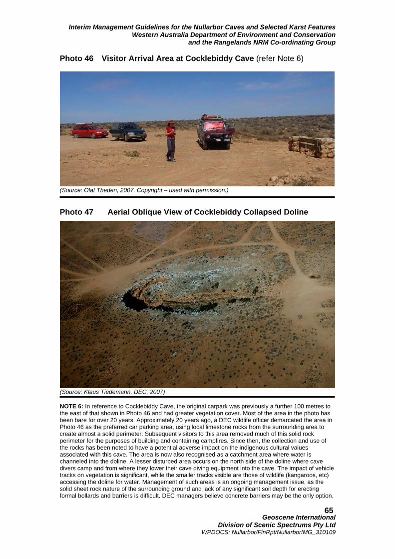
Interim Management Guidelines for the Nullarbor Caves and Selected Karst Features Western Australia Department of Environment and Conservation
and the Rangelands NRM Co-ordinating Group
Geoscene International
Division of Scenic Spectrums Pty Ltd WPDOCS: Nullarbor/FinRpt/NullarborIMG_310109
65
Photo 46 Visitor Arrival Area at Cocklebiddy Cave (refer Note 6)
(Source: Olaf Theden, 2007. Copyright – used with permission.) Photo 47 Aerial Oblique View of Cocklebiddy Collapsed Doline
(Source: Klaus Tiedemann, DEC, 2007) NOTE 6: In reference to Cocklebiddy Cave, the original carpark was previously a further 100 metres to the east of that shown in Photo 46 and had greater vegetation cover. Most of the area in the photo has been bare for over 20 years. Approximately 20 years ago, a DEC wildlife officer demarcated the area in Photo 46 as the preferred car parking area, using local limestone rocks from the surrounding area to create almost a solid perimeter. Subsequent visitors to this area removed much of this solid rock perimeter for the purposes of building and containing campfires. Since then, the collection and use of the rocks has been noted to have a potential adverse impact on the indigenous cultural values associated with this cave. The area is now also recognised as a catchment area where water is channeled into the doline. A lesser disturbed area occurs on the north side of the doline where cave divers camp and from where they lower their cave diving equipment into the cave. The impact of vehicle tracks on vegetation is significant, while the smaller tracks visible are those of wildlife (kangaroos, etc) accessing the doline for water. Management of such areas is an ongoing management issue, as the solid sheet rock nature of the surrounding ground and lack of any significant soil depth for erecting formal bollards and barriers is difficult. DEC managers believe concrete barriers may be the only option.

Interim Management Guidelines for the Nullarbor Caves and Selected Karst Features Western Australia Department of Environment and Conservation
and the Rangelands NRM Co-ordinating Group
Geoscene International
Division of Scenic Spectrums Pty Ltd WPDOCS: Nullarbor/FinRpt/NullarborIMG_310109
66
trampling of vegetation and the increase in erosion that may add to sedimentation within the caves. One of the relatively consistent findings in recreation research is that the provision of well-defined parking areas and walkways (through paving, boardwalks or other forms of hardening the pathway surface and confining visitors steps in the preferred direction) is very effective in preventing the random creation of adhoc pathways in various directions to and from recreational destinations. People will invariably choose the path of least resistance and the most obvious accessway to reach the area of interest to them. This is also true within caves for the general public, even when the designated track may be relatively narrow. In this sense, those caves that are most visited and that may become classified as Tourist Caves or Adventure Caves may require the addition of infrastructure that minimises the likely impact of visitors’ vehicles and footsteps, as well as some aesthetic landscape design and interpretive signage. The relatively sparse road system in the Nullarbor is probably one of the most useful management tools (or non-tool) available to land managers – many people may give up on looking for places they have found on internet satellite imagery when they cannot find or gain access to the right road to the locations. But, 4WD vehicles and those with more adventurous spirits can get to many places that would have been left alone in the past. Decisions about the provision of roads in the first place or the upgrading existing vehicular tracks leading to caves need to be carefully considered in the context of the eventual cave classification and management purpose. Where roads already exist, similar decisions must be made regarding the provision or non-provision of directional signage to the caves. Interpretive Facilities and Programs Although most of the caves are likely to remain unpromoted and inaccessible to the general public due to their high significance and fragility levels, this does not necessarily mean that the general public should completely miss out on the educational value and sense of awe and wonder that these caves may offer. As indicated above, some caves may be selected as Tourist Caves or Adventure Caves that are accessible to different segments of the public. Such caves may require better roads, improved directional, safety and interpretive signage, greater on-site infrastructure and possibly the implementation of guided tours with trained guides who can not only inform and interpret the caves for them, but also control and monitor visitors’ actions. Other alternatives include the provision of virtual cave tours (using sequential photography and videos), closed circuit television views into the caves (similar to the screening of bats in caves at Narracoorte World Heritage Area in South Australia), and educational DVDs and CDs that can be enjoyed in the car, at home or in schools. Lastly, the provision of a central museum on the Nullarbor Plain along the Eyre Highway or one or more visitor interpretation centres on the Nullarbor may be considered. Obviously, each of these alternatives would require further feasibility assessment. However, it has been shown in the research that visitors’ knowledge, appreciation and behaviours toward valuable and environmentally sensitive natural and cultural features make the greatest improvement when a combination of educational and interpretive techniques are utilised. These include personal contact and messages from rangers and tour guides, signage, brochures, videos, etc. Taken by themselves, especially in the case of signage and brochures, none of these methods is as effective by themselves as when combined with one or two of the other methods of educating visitors (refer to Roggenbuck, Chapter 7 in Manfredo, 1992). Usually, the more such public education and interpretive programs and facilities can be provided in locations away from the actual sites and prior to visitors going to the sites, the more effective the response.

Interim Management Guidelines for the Nullarbor Caves and Selected Karst Features Western Australia Department of Environment and Conservation
and the Rangelands NRM Co-ordinating Group
Geoscene International
Division of Scenic Spectrums Pty Ltd WPDOCS: Nullarbor/FinRpt/NullarborIMG_310109
67
Importantly, the provision of interpretive facilities and programs off-site may well satisfy much of the public curiosity about the caves and give them understanding as to why many of the caves should not be accessed, while at the same time, gaining personal knowledge and value from the existence of the caves, the karst system and their role. This, combined with the possibility of visiting selected caves (as discussed above) may be an important step in providing much greater community appreciation and sensitivity toward the Nullarbor caves and karst features. Provision of Management and Interpretive Presence Most of the above considerations would require some form of management and interpretive presence of staff or volunteers based within the Nullarbor on a full-time or at least seasonal basis. Such staff would probably need offices and other facilities located at Cocklebiddy, Madura or Eucla along the Eyre Highway. So far, DEC has not been able to justify paid full-time or part-time rangers located on the Nullarbor. Whether this may change in the future or not is unknown at this time. Other possibilities include the training and/or payment of selected volunteers who live on the Nullarbor (or who are willing to move there) to play interpretive, monitoring and regulatory roles. Currently, two volunteer resident wardens are located at Eyre. They are the eyes and ears for DEC in that part of the Nuytsland Nature Reserve. Such volunteers might be selected from among the existing local community, from among the Pastoralists who run leasehold grazing properties, from among appropriate Aboriginal communities, or from among qualified applicants to advertised positions. Another method of visitor control is to make selected caves accessible on a rotational basis during different years to allow rest periods without disruptions and impacts. 5.5 Pastoral Uses and Potential Impacts on Caves 5.5.1 Potential Impacts of Pastoral Uses As caves, blowholes and dolines are linked to the surface; pastoral uses could potentially have adverse effects on the structure, physical and biological contents and hydrology of these karst features in the following ways:
• changes to the vegetative structure or removal of vegetation and the influence of tree/shrub root systems on the meso-cavernous system of the soils and regolith and on cave passages (which may also have adverse effects on surface ecosystems, flora and fauna);
• disruption) of surface water flows (diverting away from or into) in relation to the meso-
cavernous system or into dolines, blowholes and cave entrances, affecting the hydrologic flows;
• removal of groundwater volume and interruption of aquifer flows through the
installation of water bores and wells, potentially resulting in declines in water quality and saltwater intrusion into the karst aquifer;
• effects on the quality of surface and groundwater through the introduction of
pesticides, chemicals, fertilizers, nutrients (e.g., nitrates, nitrites, phosphates, etc.), human sewage or animal wastes, or heavy metals (e.g. chromium, lead, mercury);
• development, construction, road building, and other infrastructure projects that may
lead to drainage basin alterations, decreased water quality and siltation; • construction of surface reservoirs and subsequent flooding of caves (with excavations
potentially breaking through passages that are close to the surface); and • solid waste dumping into blowholes and dolines.

Interim Management Guidelines for the Nullarbor Caves and Selected Karst Features Western Australia Department of Environment and Conservation
and the Rangelands NRM Co-ordinating Group
Geoscene International
Division of Scenic Spectrums Pty Ltd WPDOCS: Nullarbor/FinRpt/NullarborIMG_310109
68
It is thought that caves under the main, higher level Nullarbor Plain are approximately 100 m below the surface. However, many of the caves on the lower Row Plain are so shallow in depth that the tree roots grow through the cave ceilings. Pannikin Plains Cave, for instance, extends under the Eyre Highway and vehicular traffic can be heard overhead by cavers inside the passage. Although the caves known to be located closer to the surface are more vulnerable than the deeper caves, this is not to say that the deeper caves are not at all vulnerable to surface activities or that shallower caves may not exist on the main Nullarbor Plain. At present, there are two procedures in place for the assessment or monitoring of such impacts:
• firstly, the Pastoral Lands Board inspect pastoral leases on a one to six year cycle. This approach varies the inspection frequency on the categorisation of each property from “Low Concern” (assessed every six years) to “High Concern” (assessed every year). It is assumed that such impacts are reasonably under control at present, however, it would be possible for management activities to occur on a property without being observed by the PLB for a number of years;
• secondly, the Western Australian Rangeland Monitoring System (WARMs) monitors
approximately 1600 ground based sites selected to represent the pastoral Range-lands as a whole as well as areas where livestock grazing occurs. These include shrubland sites in the Southern Rangelands. The chenopod shrublands of the region receive proportionately more monitoring sites due to their relative productivity and fragility.
The WARMs process indicates that improvements have been made in the Southern Rangelands since the 1990s and observations by Watson (unpublished) suggest there have been improvements in vegetation cover and erosion since the 1960s or 1970s. However, Pringle and Tinley (Pringle et al., submitted to Landscape Ecology, 2003) have identified insidious degradation in many areas of the Southern Rangelands that they predict will be felt gradually over very long timescales unless interventions are applied. In addition, Landsberg et al. (1997) of the CSIRO Division of Wildlife and Ecology identify the following potential changes to vegetation in response to grazing where artificial water points (from water bores) are provided for sheep or cattle:
1. development of a zone of extreme degradation around the water (up to 0.5 km) where soil crust is broken, erosion is high, and forbs dominate after rain;
2. increase in the number of unpalatable perennial shrubs beyond the sacrifice
zone, particularly in semi-arid woodland and arid shrubland habitats; and 3. decrease in abundance of palatable native perennial grasses due to selective
grazing. This is not to say that any of these problems actually exist within the project area, only that they may be potential problems to that require observation and monitoring. 5.5.2 Rangelands NRM Strategy and Best Practice Guidelines The entire Nullarbor Karst System is within the Southern Rangelands and Arid Interior NRM Sub-Regions, while the project area for this report is restricted to the Southern Rangelands Subregion. Pastoralism is the industry that affects the largest geographic areas of the Western Australian Rangelands. Pastoralists are key stakeholders and the Pastoralists and Graziers Association (PGA) and Western Australian Farmers Federation (WAFF) are peak industry bodies. Land Conservation District Committees (LCDCs), local zone meetings of the PGA and Zone

Interim Management Guidelines for the Nullarbor Caves and Selected Karst Features Western Australia Department of Environment and Conservation
and the Rangelands NRM Co-ordinating Group
Geoscene International
Division of Scenic Spectrums Pty Ltd WPDOCS: Nullarbor/FinRpt/NullarborIMG_310109
69
Control Authorities (ZCAs), Landcare Groups and representatives to sub-regional NRM Groups are important participants in the NRM process. The Strategy for Managing the Natural Resources of Western Australia’s Rangelands (Rangelands NRM Co-ordinating Group, 2005) addresses rangelands management challenges through the identification and setting of performance standards and guidelines in relation to:
• priority natural resource assets; • resource condition targets (RCTs); and • management action targets (MATs).
Among the 14 key issues addressed by the RCTs and MATs are: declining soil condition, declining native vegetation integrity, declining inland aquatic water quality, altered water regimes, declining water quality/supply, declining terrestrial native species and community integrity, and decreasing primary productivity. Key RCTS include the improvement of soil surface condition (RCT3), the eradication or reduction of invasive and pest species (RCT4) and the maintenance or improvement in the density and cover of perennial vegetation (RCT5).
The MATs are grouped under five major categories:
• benchmarking and monitoring • on-ground actions • institutional frameworks, planning and policy; • education, awareness and further engagement (“capacity building”); and • cultural heritage.
An example “on-ground” MAT is for 70% of land managers to be implementing ecologically sustainable management practices by 2010. However, only 20% of properties are expected to implement best practice management soil conservation by 2010. 5.5.3 Some Specific Pastoral Issues The PBL and NRM processes are producing positive outcomes on pastoral lands of the project area. However, additional awareness-raising, training and assistance to pastoralists regarding the cave and karst values of the Nullarbor and best practice management techniques should be encouraged. More specifically, on-ground management actions, including potential fencing and revegetation may need to be considered for the recently negotiated exclusions around cave entries and dolines (refer to Section 6.4). Another specific issue that may require further attention is that of fencing-off areas surround-ing other dolines and cave entries in order to prevent excessive nutrients and weed seed from being transported into the dolines and cave entries via sheep manure in surface run-off. Any such fencing would need to be done in a way that it does not prohibit access to the dolines and caves by indigenous fauna. Lastly, it may be important for the Pastoralists to understand which parts of their pastoral leases are located directly above/close to underground cave passages or where significant dolines and blowholes occur that may require care for either biodiversity or safety reasons. CEGSA and other speleological and cave diving groups hold survey information regarding the location of many caves, however, additional surveys and surface mapping may be required. By knowing where the surface boundaries of underground cave passages are located, Pastoralists could better ensure that the indigenous vegetation over these passages are

Interim Management Guidelines for the Nullarbor Caves and Selected Karst Features Western Australia Department of Environment and Conservation
and the Rangelands NRM Co-ordinating Group
Geoscene International
Division of Scenic Spectrums Pty Ltd WPDOCS: Nullarbor/FinRpt/NullarborIMG_310109
70
protected from over grazing, fire or other activities that may harm or diminish the vegetation in those areas. In some ways, these areas located over cave passages may be treated in much the same way as riparian vegetation zones. In addition, such mapping would also assist the Pastoralists to avoid placing water bores, excavations, or heavy construction equipment within the boundaries of cave passages reflected on the ground surface. 5.6 Mining Uses and Potential Impacts on Caves 5.6.1 Potential Impacts of Mining A thorough search would be required to identify all the existing mining operations and exploration leases within the Nullarbor region. This would also require an on-going process to keep track of new leases and licenses. Mineral explorers are required by Western Australian legislation to report periodically on their programs. After a period of confidentiality, exploration reports and data are made publicly available, so that past exploration work is not unnecessarily repeated. These are referred to as open-file data. WAMEX is a searchable database of open-file reports on exploration for minerals (excluding oil and gas), and is managed by the Statutory Exploration Information Group (SEIG). Access to WAMEX is free of charge. Full digital copies of most reports are online (http://www.doir.wa.gov.au/5136.aspx ). Where a digital copy is not yet available, a microfiche copy of the report can be accessed at the Mineral House Library and at the Geological Survey's Kalgoorlie Regional Office. The total value of mining in the Nullarbor Karst region does not appear to be available. The economic value of mining is potentially significant, although not yet developed or fully verified. The Goldfields-Esperance Region produces gold, uranium and heavy mineral sands such as zircon. Mineral extraction predominantly occurs on the fringes of the Nullarbor (Kalgoorlie Terrane, Yilgarn Craton). In some other portions of the project area, potential diamond producing lands are under exploration and assessment. Paleo-channels within the Nullarbor Karst could be particularly attractive to mining explorations and future extractive activities. Other off-shore mineral exploration for petroleum and natural gas is underway and/or could potentially be expanded. The potential impacts of mining on caves, blowholes and dolines include many of the same impacts noted for pastoral land uses. Some of the key impacts of mining could include:
• oil and gas drilling on groundwater aquifers (in terms of interruption of flow, as well as potential pollution and contamination);
• removal of karst materials through quarrying activities;
• stockpile or landfill leachates contaminating surface and groundwater flows;
• physical impacts of heavy machinery or vehicles – potential collapse of cave passage
rooftops, potential damage to doline vegetation and surfaces, potential destruction of cave entry overhangs, etc.
Pastoralists concerns noted by Pringle et al. (1990) regarding mining and mining exploration activities have included:
• excessive clearing of grid lines;

Interim Management Guidelines for the Nullarbor Caves and Selected Karst Features Western Australia Department of Environment and Conservation
and the Rangelands NRM Co-ordinating Group
Geoscene International
Division of Scenic Spectrums Pty Ltd WPDOCS: Nullarbor/FinRpt/NullarborIMG_310109
71
• failure to cap drill holes or fill costeans;
• alluvial mining not followed by rehabilitation; use of hyper saline water in sluice
mining operations;
• damage to fixed station infrastructure; use of station access roads during wet weather;
• increased interference with normal station management;
• poorly sited and constructed access ways for pipelines and powerlines.
The IUCN Management Guidelines for Karst and Cave Management (1996) and members of the Steering Committee have noted the vulnerability of karst formation, ecology and ground-water quality to the percolation of contaminated water or to changes in surface water flows that percolate into the groundwater aquifers. Protection of groundwater is a particularly significant issue where mining (as well as pastoralism and other infrastructure construction) is concerned. As the Nullarbor groundwater system extends much further inland within the Eucla Basin than the Nullarbor Karst System itself, the dangers of groundwater contamination or pollution caused by mining in areas far removed from the project area are significant. 5.6.2 Mining Guideline Documents A number of guideline documents have been prepared in order to prevent or minimise adverse environmental effects of mining and mining exploration or to guide Environmental Impact Assessment, including:
• Guidelines for Mineral Exploration / Rehabilitation Activities http://www.doir.wa.gov.au/documents/environment/Exploration_Rehab_Activities.pdf
• Guidelines for the Protection of Surface and Groundwater Resources During
Exploration Drilling (Dept. of Mineral and Petroleum Resources, 2002);
• Guidance for the Assessment of Environmental Factors (in accordance with the
Environmental Protection Act 1986): Consideration of Subterranean Fauna in Groundwater and Caves during the Environmental Impact Assessment in Western Australia. No. 54 (Environmental Protection Agency, 2003);
• Guidelines for Mineral Exploration and Mining within Conservation Reserves and
other Environmentally Sensitive Lands in WA http://www.doir.wa.gov.au/documents/minealsandspetroleum/ED_Min_GL_ExpMininginConervReservesEnvSenstiveLandsWA_jan07.pdf
• Interim Code of Conduct for Mineral Exploration in Western Australia (Association of
Mining and Exploration Companies, undated);
• Guidelines for Management of Dieback Disease in Mineral Exploration http://www.doir.wa.gove.au/documents/mineralsandpetroleum/ED_Min_GL_MgmtDiebackDisease_Dec06.pdf ;
• Goldfields Land and Sea Council Mining Policy (2008).

Interim Management Guidelines for the Nullarbor Caves and Selected Karst Features Western Australia Department of Environment and Conservation
and the Rangelands NRM Co-ordinating Group
Geoscene International
Division of Scenic Spectrums Pty Ltd WPDOCS: Nullarbor/FinRpt/NullarborIMG_310109
72
5.6.3 Special Focus on Groundwater Issues DMPR Guidelines Regarding Exploratory Drilling Regarding the potential effects of exploratory drilling on groundwater resources, the WA Department of Mineral and Petroleum Resources have prepared Guidelines for the Protection of Surface and Groundwater Resources During Exploration Drilling (MPR, 2002). These guidelines are in addition to regulations for exploration drilling and construction of water bores in designated groundwater areas. In Western Australia, the land occupier must have an appropriate groundwater license and the driller must hold an appropriate drillers’ license (Classes 1, 2 or 3) issued by the Australian Drilling Association and applicable for the particular intended type of groundwater drilling and bore construction. Environmental values of groundwater include:
• stygofauna assemblages (in aquifer ecosystems); • troglobitic faunal assemblages (in caves); • groundwater dependent vegetation; • maintaining baseflows or pools in waterways; • maintaining open water or waterlogged soils in wetlands (Rangelands NRM Co-
ordinating Group, 2005); • bacterial colonies; • maintaining or protecting habitats, including those in the soil, water, root systems and
caves. Major threats to the groundwater system include potential over-extraction of groundwater, the uncontrolled flow of artesian bores, changes to flow patterns, and degradation of the water quality, all of which may pose a threat to the health and integrity of the groundwater ecosys-tems. (Threats also include human visitation and contamination - viral and bacterial.) Aquifers are considered to be vulnerable to degradation by exploratory drilling in the following ways:
• aquifers may be contaminated by entry through open boreholes by run-off water from the surface, such as in saline and industrial areas;
• aquifers containing useable-quality water being connected by drill holes to aquifers
with inferior-quality water or to leakage zones; cross flow may be induced by natural pressure differences or pressure differentials induced by pumping;
• uncontrolled flow of pressure aquifer water through drill holes between aquifers of
different quality water or through uncontrolled flow to wastage at the surface. The habitat and diversity of aquatic flora and fauna can be affected by contaminated groundwater aquifers. The Guidelines for the Protection of Surface and Groundwater Resources during Exploration Drilling (2002) identifies three types of aquifers:
• unconfined aquifers; • multi-layered aquifers; and • confined (artesian) aquifers.
The unconfined aquifers are also referred to as water table or phreatic aquifers, characterised by a groundwater body that has free exchange of pressure and moisture with the atmosphere. Rainfall on surface layers can percolate into the watertable and moisture from the watertable can also evaporate. Distinct layering of strata does not occur in these types of aquifers and little change in water level occurs when bore or exploration hills are drilled and completed.

Interim Management Guidelines for the Nullarbor Caves and Selected Karst Features Western Australia Department of Environment and Conservation
and the Rangelands NRM Co-ordinating Group
Geoscene International
Division of Scenic Spectrums Pty Ltd WPDOCS: Nullarbor/FinRpt/NullarborIMG_310109
73
Little salinity mixing takes place naturally when the drilling penetrates these aquifers, although large increases in salinity may be found with increasing depth of bores. Figure 8 shows a section drawn from the northwest to the southeast across the Eucla Basin. This illustrates the geological structure. Cretaceous Loongana Sandstone is located at the base, which forms the artesian aquifer on Roe Plains. This is overlain by shales of the Toondi and Madura Formation. The unconfined aquifer consists mainly of the Wilson Bluff Limestone and the Abrakurrie Limestone, with greensands of the Cretaceous Nurina Formation, and the Eocene Hampton Sandstone at the base. Salinity levels and their geographic distribution vary considerably when comparing those of the upper level Wilson Bluff Limestone aquifer to those of the lower level Lagoona Sandstone aquifer. Unconfined aquifers are very susceptible to contamination from surface land uses, including the disposal of industrial waste, the use of agricultural fertilisers and sprays. Where the watertable is shallow, the salinity of these aquifers may increase. Unconfined aquifers are usually found in the following areas:
• upper layers of the coastal plains; • alluvial deposits of river valleys’; • in palaeoriver systems, such as those associated with the main salt lake chains; • in the regolith, the soil and weathered hardrock layer that covers most of the inland
part of the State, including the Goldfields, Ashburton, Pilbara and Kimberley regions. Figure 8 Northwest-Southeast Geological Section of the Eucla Basin (Source: Aquaculture Groundwater Resource Atlas – Nullarbor (Eucla Basin), WA Dept. of Fisheries, 2008: http://www.fish.wa.gov.au/docs/pub/AquaGroundWater/nullarbor.php?00 ) The regolith layer extends downward into the broken, fractured and jointed hardrock zone. Multi-layered aquifers are primarily associated with layered or stratified sediments in the large sedimentary basins of the State, including the Eucla basin. Drill holes that penetrate each layer of such aquifers usually result in a change in water level, indicating that water exchange between layers may be induced by a drill hole as a result of differential pressures.
SoutheastNorthwest

Interim Management Guidelines for the Nullarbor Caves and Selected Karst Features Western Australia Department of Environment and Conservation
and the Rangelands NRM Co-ordinating Group
Geoscene International
Division of Scenic Spectrums Pty Ltd WPDOCS: Nullarbor/FinRpt/NullarborIMG_310109
74
Confined or artesian aquifers are usually found in deeper layered or stratified sediments in the large sedimentary basins of Western Australia. Major changes in water level may occur due to penetration by a drill hole to the extent that significant water flow may exist at the surface. This is a significant characteristic of multi-layered aquifers. Large pressure differentials make multi-layered aquifers highly susceptible to cross-aquifer contamination, such as salt water invading a lower pressure, good-quality water aquifer. Such aquifers may be subjected to major losses of water by free flow to the surface. They can also be significantly affected by environmental impact at the surface. Special cases may occur due to abnormal or unusual pressure situations in almost any part of Western Australia. This is particularly so in relation to hilly ground or where perched aquifers on elevated plains exist. EPA Guidance Statement No. 54 The EPA Guidance Statement No. 54 addresses the conservation of stygofauna in ground-water systems and troglofauna and stygofauna in subterranean caves. The primary focus of the guidance is to outline the technical information development proponents should collect for the assessment of the likely impacts on stygofauna. The objective of the EPA is to ensure adequate protection of important habitats for stygobitic species. In addition, on the advice of DEC, the EPA is to ensure that development proposals do not potentially threaten the viability of any subterranean species as per the Wildlife Conservation Act 1950. A formal Environmental Impact Assessment under the Environmental Protection Act is required for development proposals that could have potentially significant impacts on stygofauna or troglofaunal habitat in one or more of the following ways:
• lowering of the water table sufficiently to dry out the zone in which some species live, or otherwise artificially changing water tables; or
• changing water quality (e.g. increasing salinity levels or altering haloclines, increasing
nutrient levels or the availability of organic matter, or introducing other pollutants); or
• destroying or damaging caves (including changing their temperature and humidity). The guidance provides advice regarding the survey sampling design, demonstrating the lack of threat and the development of a management plan for the conservation of stygofauna within the impact area. Regional Water Resource Assessments Regional Water Resource Assessments (National Water Commission, 2005 http://www.water.gov.au/RegionalWaterResourcesAssessments/SpecificGeographicRegion/tabbedreports.aspx?PID=WA_GW_233b ) suggest a number of high level performance indicators of water management for the Nullarbor groundwater management unit (GMU) based on information provided by the government of WA. However, data and answers to a range of questions and key information of relevance to the National Water Initiative (NWI) do not appear to have been addressed to date, specifically in relation to:
• groundwater management framework; • water resource caps; • surface water / groundwater interaction; • sustainable groundwater yield; • environmental allowances / provisions; • groundwater diversions; and • groundwater entitlements.

Interim Management Guidelines for the Nullarbor Caves and Selected Karst Features Western Australia Department of Environment and Conservation
and the Rangelands NRM Co-ordinating Group
Geoscene International
Division of Scenic Spectrums Pty Ltd WPDOCS: Nullarbor/FinRpt/NullarborIMG_310109
75
Little monitoring of the above indicators appears to have taken place in the Nullarbor Karst region, nor is there strong evidence of a great deal of on-ground action in relation to management measures associated with these indicators. Draft NRM Strategy The Draft NRM Strategy for the Rangelands Region (Rangelands NRM Coordinating Group, 2005) indicates that the implementation of groundwater monitoring and management actions in the Carnarvon Artesian Basin Rehabilitation Project has resulted in significant water savings due to the geophysical logging of bores, water management plans, decommissioning open flowing bores, and installation of reticulation to direct water to strategic locations. The economic and environmental benefits have included:
• improved management of total grazing pressure through better distribution of water to domestic animals and greater control of non-domestic species;
• more efficient and sustainable use of natural resources through better distribution of
water; and
• increased access to water for other land uses such as tourism, aquaculture and horticulture.
In the Canning Basin, NLP funding has allowed the capping of artesian bores, resulting in the:
• removal of uncontrolled surface water to reduce the incidence of weed encroachment;
• feral animals will be easier to monitor and control as watering points will be turned on
only when required;
• pumping water from re-drilled bores to areas deficient in water will increase pastoralists’ capacity to manage grazing and reduce the pressure on single water points, where erosion risks are high; and
• using artificial watering points rather than natural water points (i.e., permanent pools
and rivers) to lessen the impact of animals on fragile riparian areas. Whether or not such management actions have been considered and tried in the Nullarbor is not known, however, if not, they could possibly be considered. Licensing and Monitoring Wells All confined wells within Western Australia require a license via the Crown for the use, flow and control of groundwater under the Rights in Water and Irrigation Act. Unconfined wells within specifically proclaimed Groundwater Areas also require licensing. Groundwater licenses have been allocated in a manner to achieve sustainable use of groundwater resources throughout the Rangelands Region. The Department of Water Resources (DWR) have also incorporated an allocation strategy and regular benchmark monitoring in sensitive and heavily utilised areas to ensure groundwater resources remain at sustainable levels for industrial, public water and environmental requirements. GLSC Mining Policy The GLSC Mining Policy requires observance of several UN conventions by mining companies. The policy outlines a number of principles for mining-related decisions (primarily to do with the protection of Aboriginal rights), the cooperative decision-making involving GLSC with the Western Australian Government, the Federal Government and the proponent where possible. Operational principles are also suggested, including the making of any traditional knowledge available to the process. This policy is primarily focused on ensuring

Interim Management Guidelines for the Nullarbor Caves and Selected Karst Features Western Australia Department of Environment and Conservation
and the Rangelands NRM Co-ordinating Group
Geoscene International
Division of Scenic Spectrums Pty Ltd WPDOCS: Nullarbor/FinRpt/NullarborIMG_310109
76
Aboriginal rights, and although mention is made of environmental issues, there is no direct reference to potential impacts on caves and associated karst features. 5.7 Transport and Communications Infrastructure Impacts The potential impacts generated by transport and communications infrastructure impacts are not much different than those noted for pastoral and mining activities. Protection of surface drainage, flora and fauna habitats, and groundwater resources are key concerns. In addition, the avoidance of placing heavy equipment or excavating over cave passages or too closely to dolines and blowholes is critical. 5.8 Aboriginal Cultural Heritage, Recognition and Co-operation As indicated under Section 4.5.5, all Indigenous cultural sites are protected by law, whether they are listed by the Department of Indigenous Affairs on the Aboriginal Heritage Register or not. In addition, it is important to acknowledge and uphold Aboriginal rights as per the United Nations Declaration on Rights of Indigenous Peoples (United Nations General Assembly, 2007). The Goldfields Land and Sea Council have adopted this standard for application when governments and others want to deal with indigenous peoples of the Goldfields-Esperance region or undertake development projects on their lands. The Declaration promotes the concept of “free, prior and informed consent”, which is also endorsed by the Australian Human Rights and Equal Opportunities Commission (HREOC). GLSC also request that in planning and managing any areas that may have Aboriginal connections, the Aboriginal knowledge of the country and culture be acknowledged and that Aboriginal management and ownership rights also be acknowledged and acted upon as appropriate. Indigenous people’s traditional use of the land for activities such as hunting, gathering native flowers, honey, etc. also needs to be facilitated as appropriate. Watson, et al. (2008), in their recent report on the Great Western Woodlands, provides a number of statements regarding Aboriginal Traditional Owners relationship and environmental knowledge of the landscape. These statements equally apply to Aboriginal relationships and knowledge of the Nullarbor landscape: “Traditional Aboriginal land use relies on intricate ecological and geographic knowledge. Over thousands of years, an intimate cultural understanding of the landscape and biota grew as successive generations watched seasons change and developed a ‘cultural map’ of their homelands. This knowledge is encoded in laws, stories, song, language, art and ritual, and has been passed through countless generations of custodians…..Historians and scientists have not yet paid enough attention to a range of customary Indigenous practices that are likely to be critical in successfully maintaining the full diversity of natural values found in the region. The long-accumulated ecological knowledge that underpins these practices is an important touchstone in understanding country…..Exercising and adapting these traditional practices to contemporary conservation and land management requires a direct management role for Traditional Owners. From the perspective of conservation science, traditional Indigenous management can be a vital part of responding to the environmental challenges. Moreover, the utilization of the latest conservation science, as well as contemporary techniques for recording and transmitting knowledge, can be a vital adaptive strategy for Indigenous custodians. Together, we can help respond to new and emerging threats” (Watson, et. al, 2008, p. 50.) 5.9 Safety and Liability Potential liability issues directly related to the Nullarbor caves, blowholes and dolines could include the following items:

Interim Management Guidelines for the Nullarbor Caves and Selected Karst Features Western Australia Department of Environment and Conservation
and the Rangelands NRM Co-ordinating Group
Geoscene International
Division of Scenic Spectrums Pty Ltd WPDOCS: Nullarbor/FinRpt/NullarborIMG_310109
77
1. potential injuries or death to cave visitors under the following circumstances:
a. while on a guided tour in a Conservation Reserve/Nat. Park; b. while on a guided tour off-reserve on Unallocated Crown Land or an
Unmanaged Reserve; c. while on a guided tour off-reserve on a Pastoral Leasehold property; d. while visiting independently with a DEC or DPI permit (either on or off-
reserve) e. while visiting independently without a DEC or DPI permit (either on or off-
reserve;
2. potential injuries or death to DEC, WA Museum or other government staff or researchers while on official business (with or without permits);
3. potential injuries or death to university researchers:
a. with permits and not on pastoral leasehold or freehold lands b. with permits and on pastoral leasehold or freehold lands c. without permits and not on pastoral leasehold or freehold lands d. without permits and on pastoral leasehold or freehold lands.
4. potential injuries or death to pastoral leaseholders, staff or guests as a result of cave passage collapse on the leasehold property:
a. with moderate to high risk areas identified and mapped for them prior to
event; b. without moderate to high risk areas identified and mapped for them prior to
event. Obviously the degree of liability and the party who is liable would depend on each situation and the exact circumstances. These situations raise the question of what “Duty of Care” and safety requirements the managing government agency or a leaseholder or freehold landholder may have in relation to:
• preparation of adequate visitor and leaseholder risk management assessments; • adequate on-site posting and broader dissemination of appropriate safety, hazard
and regulatory information to the general public and to specific special interest groups who may potentially visit the caves or work in and around them;
• fencing-off or gating caves to prevent non-permitted access;
• requirements for visitor/researcher safety training certificates, licenses, and proper
equipment for circumstances; • provision of adequate hazard and safety information within lease and permit
conditions;
• provision of adequate safety, search and rescue plans in the event of an accident;
• requirements for liability insurances by the appropriate government agency, the leaseholder or freehold landowner, the tour operator, the research organisations or the clubs involved.
DEC provides cave leadership training under its “Cave Leadership Course” for which potential caving leaders are assessed by the Cave Leader Assessment Panel (CLAP). This provides approved leaders with the capability of being issued permits with which they are allowed to take 10 to 15 caving participants into approved Tourist or Adventure Caves. The participants apparently are not required to have taken any cave leadership or safety courses. DEC also

Interim Management Guidelines for the Nullarbor Caves and Selected Karst Features Western Australia Department of Environment and Conservation
and the Rangelands NRM Co-ordinating Group
Geoscene International
Division of Scenic Spectrums Pty Ltd WPDOCS: Nullarbor/FinRpt/NullarborIMG_310109
78
appears to require cave divers to hold certificates in relation to the Australian National Competencies for Caving and Diving before cave access permits are issued. The Australian Speleological Federation (via the Western Australian Speleological Group’s website – www.wasg.iinet.net.au/asf_safe.html) provides relatively extensive Cave Safety Guidelines on its website, however, does not offer any training courses. Reference is made to the need for cave divers to be certified by the Cave Divers Association of Australia (CDAA). CDAA provides the following training courses:
• Penetration Diver Course; • Cave Diver Course; and • Deep Cavern Diver Course.
CDAA also recognise other certification and experience programs for their members. They also provide safety guidelines via the ASF, including “ASF Cave Diving – Code of Practice” (1988) and “ASF Free Diving – Code of Practice”. These codes of practice, along with the ASFs Code of Ethics and Conservation 1992 and Minimal Impact Caving Code 1995 are referred to and form part of DECs own Caving Code of Practice (refer to box on page 46). An article in Quest (Vol. 8, 2007) by Tania Yarra outlines some of the practical consideration regarding dives at Cocklebiddy and other caves of the Nullarbor. 5.10 Enhanced Management Frameworks The highly dispersed nature of the caves and associated karst features of the project area, combined with the various land tenures and management vestings involved are an indication that at a preliminary level, it may be useful for the Nullarbor Karst Management Committee to be formed with broader representation or possibly investigate the appropriateness of forming some other regional management body that will provide for more of the key stakeholders and vested management authorities to be involved in joint decision-making regarding future land use and conservation management in the region, particularly regarding caves, blowholes and dolines. Following on from the 2002 Biodiversity Audit recommendations and those of Subterranean Ecology (2007) and previously by Davey et al. (1992), continuing examination of how caves and karst features might best be protected and conserved should be examined over the next five years. Whether these resources are managed within a CAR Reserve System, the Conservation Estate or in other protective management agreements with Pastoral Leaseholders and Freehold land owners of the Nullarbor, it will be important to assess and prioritise the caves, blowholes and dolines for inclusion under various land tenure and management framework categories. Along with this, consideration may also be given to the various levels or forms of protected area management, given the high significance and vulnerability of the Nullarbor karst. While assuming the retention of the current land tenure arrangements, these framework categories could possibly include:
• a Nullarbor Sub-Regional Plan (co-ordinated by DEC); • a regional management authority; • a UNESCO Man and the Biosphere Programme “Biosphere Reserve”; • a World Conservation Union (IUCN) “Indigenous Protected Area”; • a UNESCO “Geopark” (Global Geoparks Network); or • a UNESCO (World Heritage Commission) World Heritage Site.
All of these categories for protected areas could be established while maintaining and including the existing Pastoral leaseholds on the Nullarbor. However, within the IUCN Protected Area Management Categories, only Category VI - Managed Resource Protected Area, would seem to allow for pastoral uses. This category is also used, but not generally funded, under Australia’s National Reserve System Program.

Interim Management Guidelines for the Nullarbor Caves and Selected Karst Features Western Australia Department of Environment and Conservation
and the Rangelands NRM Co-ordinating Group
Geoscene International
Division of Scenic Spectrums Pty Ltd WPDOCS: Nullarbor/FinRpt/NullarborIMG_310109
79
In addition, regardless of which of the above categories may be selected, protection by the Western Australian State Government through CALM Act planning is assumed and required. 6 Recommended Interim Management Guidelines 6.1 Introduction to the Guidelines The following Interim Management Guidelines are recommended to address key issues that may need to be addressed within the next five years. These guidelines are not meant to replace existing legislation, regulations or policies relevant to the Nullarbor caves, blowholes and dolines within the project area, but should be complimentary. These guidelines should also be acceptable, realistic and achievable as viewed by all relevant government management agencies and stakeholders. These guidelines are not meant to form a management plan at this time, but to provide guidance and direction for the management of key issues and the implementation of certain operational objectives and infrastructure that may arise in the interim. 6.2 Interim Management Guidelines for the General Management
and Use of Caves 6.2.1 IMG 1: Vesting of Cave Management A brief Discussion Paper should be prepared and considered regarding the vesting of primary responsibility for management of all caves, blowholes and dolines in the Nullarbor karst system with a single State Government authority for the purposes of rationalising and better managing g issues of visitor use, user permits, management classifications, facility provision, risk management, monitoring use and condition, safety and liability, and public relations and education regarding use. Although DEC would seem to be the logical authority to take on the central responsibility for cave and related karst resources, the appropriate agency should be given consideration and recommendation by a joint committee with appropriate representation. This may require some minor adjustments to existing regulations and management guidelines. Key Partnerships: DEC, DPI, PBL, SLS, DIA, GSLC and WAM. 6.2.2 IMG 2: Management Advisory Committee The Caves Management Advisory Committee (CMAC) has been established to assist with the management of the caves in the Leeuwin-Naturaliste National Park and other areas of southwest Western Australia. CMAC may provide a model that can be considered for the establishment of a similar advisory committee for the Nullarbor caves and karst area, perhaps to be referred to as the Nullarbor Caves and Karst Management Advisory Committee (NCKMAC)7. Although there may be some cross-membership between CMAC and NCKMAC with one or two members initially, both areas require separate people with good knowledge of each region and the specific cave and karst resources of each. In addition, in consideration of time demands on committee members, it is best to have different people serving on the different committees. The committee should include representatives from the relevant Aboriginal communities, the local Nullarbor community, pastoralists, speleologists and other specialists. NOTE 7: NCKMAC could potentially substitute for the listing of key partnerships with ASF, ACKMA, WASG, SRGWA, CDAA, WAM, GLSC, Tourism WA and Pastoralists as indicated in the following IMGs.

Interim Management Guidelines for the Nullarbor Caves and Selected Karst Features Western Australia Department of Environment and Conservation
and the Rangelands NRM Co-ordinating Group
Geoscene International
Division of Scenic Spectrums Pty Ltd WPDOCS: Nullarbor/FinRpt/NullarborIMG_310109
80
Key Partnerships: DEC, DPI, ASF, ACKMA, WASG, SRGWA, CDAA, WAM, GLSC, and local community and pastoralist representatives. 6.2.3 IMG 3: Cave Access Permit System Consideration should be given to standardising, rationalising, strengthening and promoting the Cave Access Permit System. Extend and improve the application of the current DEC Cave Access Permit System as a central procedure and regulation implemented by DEC and DPI. Consider how the same procedure can be applied by both government agencies or whether only one of them (likely DEC) should be vested with the responsibility as per IMG 1. Along with this, the regulations regarding the requirement for all cave visitors to have a permit prior to entering any cave in the Nullarbor region should be considered for any necessary improvement or strengthening. Some flexibility should be built into the permit process to consideration a higher level of security clearance for some cave explorers who have proven themselves to be more experienced, safe and trust-worthy. The permit requirements should be more widely advertised and promoted among all specialist dry caving groups, cave diving groups, outdoor education leaders, tour operators and the general community. Consideration should be given to standardising all Caving Leader/Cave Diving Leader training courses, required qualification certificates and licenses. In addition, streamlining and automating as much of the permit system and its record-keeping functions should be examined, including the use of specialised cave permit software and karst management database such as TRIPMan (Webb, 2006). Annual records of the number of visitors, length of stay, purpose and activities in each destination should be maintained in as detailed a manner as possible to assist with the longer term management planning needs of the area. Key Partnerships: DEC, DPI, ASF, ACKMA, WASG, SRGWA, CDAA, WAM, GLSC, and Tourism WA 6.2.4 IMG 4: Cave Management Classification System A preliminary application of the DEC Cave Management Classification System should be applied to the caves, blowholes and dolines currently listed on the CEGSA Cave Prioritisation or Risk Assessment list and to any other caves that receive notable use. (An example of the DEC Cave Management Classification System is shown in Table 4). This should incorporate and improve on the current Cave Risk Assessment, giving due consideration to classifying and prioritising caves, blowholes and dolines based on a full range of values as those can practically be assessed (including biodiversity ranking, speleological values and vulnerability, archaeological, palaeological, and Indigenous cultural values, etc.). Key Partnerships: DEC, DPI, ASF, ACKMA, WASG, SRGWA, CDAA, WAM, GLSC, Tourism WA and Pastoral Leaseholders with caves being classified. 6.2.5 IMG 5: Assessment of Cave Risks to Visitors What is currently referred to as the CEGSA Cave Prioritisation or Risk Assessment Table may be misconstrued by some as a comprehensive “risk assessment” rather than as a limited “cave vulnerability” table. It should be renamed and incorporated into the Cave Management Classification System (as per IMG 4). As resources permit and based on cave classifications and prioritisation resulting from IMG 4, assessments of cave risks to visitors who may enter caves should be assessed using

Interim Management Guidelines for the Nullarbor Caves and Selected Karst Features Western Australia Department of Environment and Conservation
and the Rangelands NRM Co-ordinating Group
Geoscene International
Division of Scenic Spectrums Pty Ltd WPDOCS: Nullarbor/FinRpt/NullarborIMG_310109
81
appropriate geophysical and Australian Standard risk assessment procedures. Other factors should be considered when assessing risks to visitors, such as the type of visitor group, their experience and qualifications, the type of equipment used for different areas and purposes. The risk assessments should be maintained in a central database for referral and consider-ation in the application of the Cave Management Classification System and the Cave Access Permit System. The classification of caves as Tourist, Adventure or Restricted Access should be dependent on the assessment of cave risks to visitors. The priorities for determining which caves should be assessed for their risks to visitors should be influenced by a preliminary assessment of which caves should be categorised into which cave classification (i.e., it is likely that caves considered for the Tourist Cave classification should be assessed for their risks to visitors first to determine whether the level of risk may be too great or cost too much to mitigate for certain caves to be considered for the Tourist Cave category). To this extent, this guideline raises a potential “chicken-or-egg-first” dilemma. However, for interim purposes, it is probably more practical to complete preliminary cave classifications first, followed by risk assessments of specific caves as time and budget permit. Key Partnerships: DEC, DPI, PBL/SLS, ASF, ACKMA, WASG, SRGWA, CDAA, WAM, GLSC, Tourism WA and Pastoral Leaseholders. 6.2.6 IMG 6: Locked Access for Selected Caves Based on the outcomes of IMG 4 and IMG 5, selected caves should be considered by NCKMAC for fencing, gating and locking as time and budget permit. When locked gates or doors are involved, care should be taken that existing diurnal air flows into and out of caves is maintained unimpeded. The natural movement of fauna in and out of the caves should also not be impeded (i.e., for bats, owls and other fauna as appropriate.). All fencing and locking of access gates should preferably be implemented as part of a site development plan and landscape design concept plan. Key Partnerships: DEC, DPI, ASF, ACKMA, WASG, SRGWA, CDAA, WAM, GLSC, Tourism WA and Pastoral Leaseholders with caves being classified. 6.2.7 IMG 7: Fencing Cave Reserves within Pastoral Leaseholds Caves and cave reserves located within pastoral leasehold areas should be fenced (if not gated and locked as per IMG 6). This would include, but not be limited to areas recently reserved as part of the 2015 Pastoral Review, including:
• Madura Station
o Madura Cave (25 ha) o Mullamullang Cave (25 ha) o Kestrel Cavern No 1 (25 ha) o Kestrel Cavern No 2 (25 ha) o Roaches Rest (25 ha)
• Moonera Station
o Moonera Tank Cave (100 ha)
• Mundrabilla Station o Webbs Cave / including the entrance to Snake Pit Cave (51 ha) o Thampanna Cave (37 ha) o Witches Cave (25 ha).

Interim Management Guidelines for the Nullarbor Caves and Selected Karst Features Western Australia Department of Environment and Conservation
and the Rangelands NRM Co-ordinating Group
Geoscene International
Division of Scenic Spectrums Pty Ltd WPDOCS: Nullarbor/FinRpt/NullarborIMG_310109
82
The objective of such fencing is to:
• keep sheep and other livestock well away from cave entrances, blowholes and dolines to prevent or minimise the potential effects of livestock manure and contaminants from being transferred into cave passages;
• keep domestic livestock from falling into caves, dolines and blowholes; • keep land managers and mining exploration teams and their equipment from falling
into cave openings or causing cave passages to collapse underneath them. Such fencing should be designed and installed in a manner that ensures native fauna can move freely to and from the cave/passage entrances without being impeded or placed under stress or danger, while ensuring that sheep and other livestock remain out of the excluded reserve. Key Partnerships: DEC, PBL, DPI, NRM Rangelands, ACKMA, ASF and Pastoral Leaseholders with caves being classified. 6.2.8 IMG 8: Visitor Impact Monitoring Methods Visitor Impact Monitoring methods should be considered (as discussed in Section 5.3.8) and the most suitable methods selected for future implementation. The TOMM and LAC methodologies are particularly suggested for evaluation. (This review could be done by an outside consultant.) Interim assessment of cave condition should take place for several caves as selected through the Cave Management Classification process (IMG 3), as time and budget permit. Key Partnerships: DEC, DPI, ACKMA, WAM, GLSC, ASF and any Pastoral Leaseholders with caves being assessed. 6.2.9 IMG 9: Field Management Staffing Alternatives Prepare a brief discussion paper regarding future field management staffing alternatives, including trained local volunteers, pastoral leaseholders and staff, Aboriginal people from the appropriate communities, DEC staff members or staff jointly funded by the Western Australian and South Australian Governments that can cover the whole of the Nullarbor karst system throughout both States. Depending on future cave classifications, interpretive programs and infrastructure, the staff may serve roles ranging from conservation management and monitoring to the provision of visitor information and interpretation to cave permit and land use regulation and enforcement. The number of staff and skill-set requirements should also be considered. The discussion paper should be discussed among appropriate State Government agencies and appropriate stakeholders. Key Partnerships: DEC, DPI, NRM Rangelands, ACKMA, ASF, GLSC and SA Dept. of Environment and other stakeholders as appropriate. 6.2.10 IMG 10: Cave-Related Capital Works Cave-related capital works should be considered and prioritised for future implementation as funding becomes available. This would take into consideration a combination of factors as addressed in several of the IMGs above, including cave management classifications, cave risks to visitors, relative visitor demand, locked access and fencing needs, etc. Identified Tourist Caves and Adventure – Class 1 caves may be identified that require safety and interpretive signage, directional signage along access routes, carparking and walking track improvements, etc. Once priorities for works are established, work plans, site development

Interim Management Guidelines for the Nullarbor Caves and Selected Karst Features Western Australia Department of Environment and Conservation
and the Rangelands NRM Co-ordinating Group
Geoscene International
Division of Scenic Spectrums Pty Ltd WPDOCS: Nullarbor/FinRpt/NullarborIMG_310109
83
plans and cost estimates should be progressively prepared and implemented as approvals are granted and funding becomes available. Key Partnerships: DEC, DPI, ACKMA/ASF, PBL/SLS and affected Pastoral Leaseholders. 6.2.11 IMG 11: Visitor Interpretation Feasibility Study DEC and the proposed NCKMAC may find that the interim management period provides a good opportunity to conduct a feasibility study into the potential provision of various interpretive facilities (e.g. interpretive and directional signage systems, boardwalks, parking and other visitor facilities, information brochures/booklets, CDs, DVD videos or TV programs) and possibly even a feasibility study into a future visitor centre for the area. Such a feasibility investigation goes hand-in-hand with IMG 4, IMG 5, IMG 8, IMG 9 and IMG 10. Conducting feasibility investigations of this nature during an interim management period without being rushed to respond to a political or economic directive is ideal and provides highly useful information for integration into a more permanent management plan for the area when that time comes. Key Partnerships: DEC, DPI, Tourism WA, ACKMA, ASF and Local Governments (Shire of Dundas, Shire of Esperance and City of Kalgoolrie-Boulder). 6.2.12 IMG 12: Groundwater Protection Extractions of and leakages or infusions into the Nullarbor groundwater system may occur through pastoral, mining exploration, road construction, and other land uses. These activities may have potential adverse effects on Nullarbor caves and karst features through the quantity and quality of groundwater recharge zones and confined or unconfined groundwater aquifers. Land use activities potentially affecting the groundwater should be considered through more integrated review and impact assessment procedures within the planning and land lease approval systems. Such uses might be considered to trigger a referral to the suggested single authority over Nullarbor caves and karst (IMG 1) and/or the suggested Nullarbor Caves and Karst Management Advisory Committee (IMG 2) before lease and planning approvals are granted. (This would be somewhat similar to the referral process used by Local Government Councils when referring planning applications to other relevant Authorities for comment prior to approval or similar to the Native Title trigger for Mining Leases.). Uses that would potentially cause unacceptable impacts on recharge zones, groundwater quantities (or levels); groundwater quality, groundwater flow rates or groundwater-based fauna (stygofauna) should not be approved. Key Partnerships: DEC, DPI, DWR, DIR, PBL, SLS, NRM Rangelands, ASF/ACKMA and Local Government within the region (Shire of Dundas, Shire of Esperance and City of Kalgoorlie-Boulder). 6.2.13 IMG 13: Ecosystems, Flora and Fauna Conservation The biodiversity of indigenous flora and fauna should continue to be identified and protect with an emphasis on ecosystems, species and communities at risk. Surface and subterranean flora and fauna species and taxa declared as protected under the Environment Protection and Biodiversity Conservation Act 1999 (Cth EPBC Act), the Conservation and Land Management Act 1984 (WA) or the Wildlife Conservation Act 1950 (WA) should be given management priority and conservation protection as required. Other recommendations regarding subterranean flora and fauna in terms of conservation, protection, action programs, recovery programs and research as recommended by

Interim Management Guidelines for the Nullarbor Caves and Selected Karst Features Western Australia Department of Environment and Conservation
and the Rangelands NRM Co-ordinating Group
Geoscene International
Division of Scenic Spectrums Pty Ltd WPDOCS: Nullarbor/FinRpt/NullarborIMG_310109
84
Subterranean Ecology (2007), the 2002 Biodiversity Audit and subsequent flora and fauna investigations should be considered and prioritised according to their urgency and available staffing and budgets. In general, key actions should include:
1. Protect flora and fauna species listed under the EPBC Act 1999, the Wildlife Conservation Act 1950 and the CALM Act;
2. Apply recommendations of A Biodiversity Audit of Western Australia’s 53
Biogeographical Subregions in 2002 (Dept. of Conservation and Land Management, 2003);
3. Apply recommendations of NRM Strategy for the Rangelands Region of Western
Australia (Rangelands NRM, 2005); 4. Apply prescribed fire to conserve biodiversity according to DEC policy; 5. Prepare and implement approved recovery plans according to biodiversity priorities
identified in the Biodiversity Audit (2002) or in further investigations; 6. Implement measures to mitigate impacts various threatening processes as identified,
including that of visitor use to sensitive plant species or communities; 7. Prioritise and conduct specific research and monitoring activities; 8. Consider designation of new reserves in the Conservation Estate (as per Davey, et
al. 1992 and according to priority species and taxa as identified in the 2002 Biodiversity Audit;
9. Capacity building of community groups, land and lease holders through projects such
as the Macro Corridor project as referenced in A Biodiversity Audit of Western Australia’s 53 Biogeographical Subregions in 2002 (Dept. of Conservation and Land Management, 2003. Refer to the 2002 Biodiversity Audit (Dept. of Conservation and Land Management, 2003) and Subterranean Ecology (2007) for detailed recommendations.
Key Partnerships: DEC, NRM Rangelands, DPI, PBL, ASF, Pastoral Leaseholders and South Australia’s Dept. of Environment and Heritage. 6.2.14 IMG 14: Threatening Pest Animal and Plant Control Apply recommendations of A Biodiversity Audit of Western Australia’s 53 Biogeographical Subregions in 2002 (Dept. of Conservation and Land Management, 2003) and other more recent programs for the control of pest animals and plants that threaten indigenous flora and fauna species. Implement specific targeted projects within a 5 year timeframe where possible and achievable. Carry out localised mapping, control or eradication of targeted species. Continue monitoring programs and existing controls on feral animals (e.g. wild dogs, feral cats, fox, rabbits and starlings), adjusting and expanding eradication where necessary. Priorities should focus on endemic vegetation communities and indigenous plant species in some Nullarbor dolines that are under immediate threat of displacement/smothering by introduced weeds (e.g. at Webbs Cave, Chapel Rock doline, Madura Cave and some more recently discovered caves on the Roe Plain).

Interim Management Guidelines for the Nullarbor Caves and Selected Karst Features Western Australia Department of Environment and Conservation
and the Rangelands NRM Co-ordinating Group
Geoscene International
Division of Scenic Spectrums Pty Ltd WPDOCS: Nullarbor/FinRpt/NullarborIMG_310109
85
Horehound, Deadly Nightshade, Wards Weed and Onion Grass are some of the pest weed species. Horehound seed, due to its sticking ability to clothes/ socks/ vehicles for instance can be easily, yet most of the time unknowingly, transported from one doline to another or to moisture-gaining areas. Key Partnerships: DEC, NRM Rangelands, DPI, PBL, Pastoral Leaseholders and South Australia’s Dept. of Environment and Heritage. 6.2.15 IMG 15: Fire Control The objectives and strategies recommended by the Draft South Coast Regional Fire Management Plan 2008-2013 should guide responses to fire in the Nullarbor region. The recommendations of the report Fire Management in the Rangelands (Tropical Savannas and Desert Knowledge Cooperative Research Centres, 2004) should also be considered. Key Partnerships: DEC, Shire of Dundas, the Fire and Emergency Service Authority (FESA), NRM Rangelands, and Pastoral Leaseholders. 6.2.16 IMG 16: Protection of Cultural Heritage Sites Indigenous and non-indigenous cultural heritage sites and places should be conserved and protected as required by the Aboriginal and Torres Strait Islander Heritage Protection Act 1984, Aboriginal Heritage Act 1972 (WA), Heritage of Western Australia Act 1990 and other relevant legislation and policies. Any planned development or excavations that may potentially affect archaeological or heritage features, fabric, sites or places should be referred to the appropriate government authorities, custodians and/or Traditional Owners for further assessment and approvals prior to any disturbance or alterations to the sites. With the agreement of DIA and GLSC, data on cultural heritage sites may be considered for inclusion or linking to the Karst Management database(s) such as mentioned in IMG 3, however, culturally sensitive sites may not always be made publicly known. Hence, this would not eliminate the requirement for due planning processes to take place. Key Partnerships: DEC, DPI, PBL, SLS, DIA, GLSC, HCWA, WAM (and DEHWA as appropriate). 6.2.17 IMG 17: Holistic and Best Management Practices It should be recognised that the Nullarbor caves and associated karst system is highly complex, interconnected and vulnerable. A “whole-of-system”, integrated and multi-disciplinary planning and management philosophy and approach should be encouraged. Best practice guidelines for caves and karst landscapes, such as those recommended in the box below, should be referred to and considered for all land use, conservation and visitor management decisions. Key Partnerships: DEC, NRM Rangelands, ASF and all other involved agencies and stakeholders. 6.3 Interim Management Guidelines for Specific Pastoral Issues 6.3.1 IMG 18: Surveys and Fencing of Areas above Cave Passages Existing surveys of the boundaries of areas directly above or close to known cave passages should be made available to pastoral leaseholders for conservation and safety purposes. Pastoralists should be encouraged to fence these areas off where practical from grazing sheep and livestock where such activity may adversely impact upon the indigenous vegetation important to meso-cavern and cave ecosystems and hydrology. These areas

Interim Management Guidelines for the Nullarbor Caves and Selected Karst Features Western Australia Department of Environment and Conservation
and the Rangelands NRM Co-ordinating Group
Geoscene International
Division of Scenic Spectrums Pty Ltd WPDOCS: Nullarbor/FinRpt/NullarborIMG_310109
86
should also be clearly marked and/or fenced off where practical to prevent undesirable boring for water, excavations, leakage of human/animal wastes or chemical pollutants and to avoid the possible danger of heavy vehicular or farming equipment causing cave collapses. To a certain degree, these fenced off areas may potentially serve a similar purpose as riparian vegetation corridors or biolinks. Any such fencing should be implemented in an environmentally sensitive manner to avoid possible adverse impacts and to minimise drawing attention to the karst feature. Where existing surveys are not available from CEGSA, the ASF or other organisations, then priorities should be set for the surveying of known caves and the preparation of ground surface “footprint” maps for reference. [Note: to protect caves that are classified as Restricted Access or which have locations that are not to be available to the general public, the survey maps of cave passage locations should be kept in the strictest secrecy and confidentiality]. Key Partnerships: DEC, DPI, PBL, CEGSA/ASF, ACKMA and affected Pastoral Leaseholders. 6.3.2 IMG 19: Surface Drainage and Farm Dam Construction Changes to surface drainage and the siting and construction of farm dams may have potential adverse effects on caves, blowholes, dolines or the karst hydrologic system. Pastoral leaseholders should consult with DEC regarding significant proposed changes to surface drainage or the proposed construction of farm dams or reservoirs that could potentially affect the surface footprint of known cave passages (IMG 18) or the meso-catchment surrounding the entrances to caves, blowholes or dolines. Key Partnerships: DEC, DPI, PBL, ACKMA, ASF and affected Pastoral Leaseholders 6.4 Interim Management Guidelines for Mining, Transport and
Communications Infrastructure Uses 6.4.1 IMG 20: Excavations and Drilling Above Cave Passages Excavations, exploratory or bore water drilling and other construction or extraction works directly above or close to known cave passages should be avoided where ever possible. Proposed works are subject to the normal planning approvals process and to planning, mining and environmental impact assessment regulations as required by the Land Administration Act 1997 (LAA, WA), Environmental Protection Act 1986, Conservation and Land Management
Cave and Karst Management Best Practice References
• Watson, John; Hamilton-Smith, Elery; Gillieson, David; Kiernan, Kevin, Eds., 1997. Guidelines for Cave and Karst Protection. Prepared for the World Commission on Protected Areas (WCPA) Working Group on Cave and Karst Protection, IUCN – The World Conservation Union.
• Elery Hamilton-Smith, 2006. Spatial Planning and Protective Measures for Karst
Areas 2006, in ACTA Carsologica 35/2, 5-11, Ljubljana.
• British Columbia Ministry of Forests, 2003. Karst Management Handbook for British Columbia.
• Karst Waters Institute, 2003. Recommendations and Guidelines for Managing
Caves on Protected Lands. Jones, et al. contributors.

Interim Management Guidelines for the Nullarbor Caves and Selected Karst Features Western Australia Department of Environment and Conservation
and the Rangelands NRM Co-ordinating Group
Geoscene International
Division of Scenic Spectrums Pty Ltd WPDOCS: Nullarbor/FinRpt/NullarborIMG_310109
87
Act 1984 (WA), Mining Act 1978, Petroleum Act 1967, Industry and Technology Development Act 1998, and other relevant legislation and policies. The potential effects of exploratory drilling on groundwater resources should be minimised by applying the Guidelines for the Protection of Surface and Groundwater Resources during Exploration Drilling (WA Department of Mineral and Petroleum Resources, 2002). Existing surveys of ground surface “footprint” maps for areas above cave passages available from DEC, CEGSA, or the ASF should be referred to during the process of planning any mining, drilling, road works or other excavations within the Nullarbor karst region. Cave passage footprint areas already fenced off (IMG 18) on pastoral leasehold properties or elsewhere should not be selected for such operations. Where such ground surface “footprint” surveys have not been completed for known caves, such surveys should be prepared prior to planning development, exploration and construction sites. (In order: to protect caves that are classified as Restricted Access or which have locations that are not to be available to the general public, the survey maps of cave passage locations should be kept in the strictest secrecy and confidentiality.) Key Partnerships: DEC, DPI, DIR, PLB/SLS, Australian Rail Track Corporation Ltd (ARTC), EPA, ACKMA/ASF, Local Governments within the region (Shire of Dundas, Shire of Esperance and City of Kalgoorlie-Boulder), and all mining, telecommunications and railway companies operating in the area. 6.4.2 IMG 21: Surface Drainage Changes by Mining and Infrastructure Changes to surface drainage and the siting and construction of works related to mining, roads, railways, telecommunications or other infrastructure may have potential adverse effects on caves, blowholes, dolines or the karst hydrologic system. Agents and representatives of such mining and infrastructure organisations or companies should consult with DEC regarding any proposed changes to surface drainage or the proposed construction of dams or reservoirs that could potentially affect the surface footprint of known cave passages (IMG 18) or the meso-catchment surrounding the entrances to caves, blowholes or dolines. Key Partnerships: DEC, DPI, DIR, PBL/SLS, EPA, ACKMA/ASF, Australian Rail Track Corporation Ltd (ARTC), Local Governments within the region (Shire of Dundas, Shire of Esperance and City of Kalgoorlie-Boulder), and all mining, telecommunications and railway companies operating in the area. 6.5 Interim Management Guidelines Related to Aboriginal Recognition
and Co-operation 6.5.1 IMG 22: Aboriginal Rights, Knowledge and Co-operative
Management In all management decisions and activities regarding Nullarbor caves and associated karst areas, Aboriginal rights as per the United Nations Declaration on Rights of Indigenous Peoples (United Nations General Assembly, 2007) should be acknowledged and upheld. Management and development activities should adhere to all requirements of the Aboriginal and Torres Strait Islander Heritage Protection Act 1984, the Native Title Act 1993 (Cth), the Aboriginal Heritage Act 1972 (WA) and any other relevant legislation and policies. The Goldfields Land and Sea Council should be contacted regarding the involvement and co-operation of Indigenous communities and Traditional Owners. The concept of “free, prior and informed consent” should be implemented as per the United Nations Declaration on Rights of Indigenous Peoples (United Nations General Assembly, 2007).

Interim Management Guidelines for the Nullarbor Caves and Selected Karst Features Western Australia Department of Environment and Conservation
and the Rangelands NRM Co-ordinating Group
Geoscene International
Division of Scenic Spectrums Pty Ltd WPDOCS: Nullarbor/FinRpt/NullarborIMG_310109
88
In planning and managing any areas that may have Aboriginal connections, the Aboriginal knowledge of the country and culture be acknowledged and that Aboriginal management and ownership rights also be acknowledged and acted upon as appropriate. Indigenous people’s traditional use of the land for activities such as hunting, gathering native flowers, honey, etc. should be facilitated as appropriate. Key Partnerships: DEC, DPI, PBL, SLS, DIA, GLSC, local Indigenous Communities, Traditional Owners, Pastoral Leaseholders and development proponents as appropriate. 6.6 Interim Management Guidelines Regarding Safety and Liability
Issues 6.6.1 IMG 23: Risk Assessments and Management Risk assessments for caves and associated karst features should be prepared as per IMG 5 in relation to use by tourists, recreationists, researchers, pastoralists, government staff members and other visitors. Specialist risk assessment and management expertise should be sought wherever necessary. Areas of potential liability should be reviewed in terms of the “duty of care” and responsibilities of DEC, DPI, PBL and SLS. Actions and safety measures to eliminate or minimise the risk should be taken on a priority basis. Any capital works required to implement such actions or safety measures should be carried out according to assessed priorities and available funding. In lieu of or in addition to such measures, hazard warnings, safety signage and notices or other information should be provided as appropriate to the general public, to leaseholders and to contractors who may be in the Nullarbor area. Any legal provisos declaring that vested management authorities are not liable for potential damages to property or injury/death to persons should be clearly included in any lease agreements, permits or contracts as advised by independent legal advisors. Consideration should be given to any accident liability and/or health/life insurance requirements for cave access permit-holders, pastoral leaseholders, researchers or other parties visiting or working in or near caves, blowholes or dolines Key Partnerships: DEC, DPI, PBL/SLS, ASF, ACKMA, WASG, SRGWA, CDAA, WAM, GLSC, Tourism WA and Pastoral Leaseholders. 6.7 Enhanced Management Frameworks 6.7.1 IMG 24: Preliminary Review of Enhanced Management
Frameworks The highly dispersed and vulnerable nature of the caves and associated karst features of the project area, combined with the various land tenures and management vestings involved are an indication that at a preliminary level, it may be useful for the Nullarbor Cave and Karst Management Advisory Committee to investigate the appropriateness of forming some other regional management body that will provide for more of the key stakeholders and vested management authorities to be involved in joint decision-making and co-management regarding future land use and conservation management in the region, particularly regarding caves, blowholes and dolines. This guideline follows on from the 2002 Biodiversity Audit recommendations and those made by Subterranean Ecology (2007) and previously by Davey et. al. (1992), continuing examination of how caves and karst features might best be protected and conserved should be carried out over the next five years.

Interim Management Guidelines for the Nullarbor Caves and Selected Karst Features Western Australia Department of Environment and Conservation
and the Rangelands NRM Co-ordinating Group
Geoscene International
Division of Scenic Spectrums Pty Ltd WPDOCS: Nullarbor/FinRpt/NullarborIMG_310109
89
Further discussion of this issue and some of the alternative management frameworks that could be explored, each of which could allow continued use of Pastoral Leaseholds is provided in Appendix 10. 7 Next Steps: Where to from Here? 7.1 Introduction This report has covered a great number of issues and considerable information. It should not be expected that all of this information can be fully understood and implemented through simple written documentation. There will be a need to discuss and explain the purpose of the report and the Interim Management Guidelines to the Nullarbor and wider Western Australian communities, to the key stakeholder groups and to various government staff members within DEC, Rangelands NRM and other government departments. It will also be helpful to receive further feedback in the form of comments and suggestions from the key stakeholders and community members. Beyond communicating the IMG review and recommendations, there will be a need to implement the suggested measures and actions. The most important aspect of this will be the resolution of a central government agency to take overall responsibility for the management of caves, blowholes and dolines, regardless of where they occur in relation to the various land tenures of the Nullarbor region. Most likely, DEC should assume this role, however, this issue needs to be discussed and agreed upon by all agencies with land administration and management vestings in the region. In some cases, aspects of these vestings may need to be formally given over to the central agency selected. Along with the resolution of a central government department for the management of Nullarbor caves and associated karst features will be the establishment of the proposed Nullarbor Cave and Karst Management Advisory Committee (NCKMAC) and the appointment of committee members. The formation of a highly knowledgeable and functional committee to assist the responsible government agency with resource assessments and management decisions will be a very important step. Finally, it must be remembered that this report does not address all aspects of the entire Nullarbor Karst System, which covers a much larger area and many more features and landscapes than simply the caves, blowholes and dolines that are the current focus. It should also be remembered that the current report only suggests “Interim” management guidelines. Over the next five years, DEC, Rangelands NRM and other partner agencies and organisations should prepare the way for, if not complete, a Nullarbor Karst System Management Plan that addresses the entire karst region and the full compliment of resource and management issues. 7.2 Community Awareness and Consultation It is important that the community at large, especially the Nullarbor community, and various key stakeholders and management partners become aware of just what a significant place the Nullarbor region is regarding its caves, other karst features, ecosystems and the full range of unique, rare, vulnerable and outstanding values as measured on a world and national basis. This may be best achieved through community workshops, but may also be facilitated through the distribution of the report and the potential production of CDs, DVD videos, television, radio and internet programs. The process of revealing and appreciating these values would also contribute to the enhancement of community self-esteem and capacity building. It is suggested that following the printing of this report, a series of community workshops and awareness –raising programs be developed and executed. These workshops could also

Interim Management Guidelines for the Nullarbor Caves and Selected Karst Features Western Australia Department of Environment and Conservation
and the Rangelands NRM Co-ordinating Group
Geoscene International
Division of Scenic Spectrums Pty Ltd WPDOCS: Nullarbor/FinRpt/NullarborIMG_310109
90
serve as vehicles to stimulate community comments and suggestions regarding the Interim Management Guidelines. 7.3 On-going Field Research, Survey Investigations and Cultural
Development This report and the recommended IMGs have not focused on the needs for on-going field research, survey investigations and cultural development. Numerous areas of science, natural and cultural resource management, tourism and recreation management and areas of the arts should continue to be addressed. Research should continue in the fields of archaeology, paleontology, geology/geomorphology, the mineral sciences, biology, botany, ecology, climatology and paleo-climatic studies, among many other areas. Further work in the areas of natural resource assessment, management and monitoring will be required. The area of speleology and cave management alone provides a lifetime of work for many, many researchers. Culturally, there are many more areas that can and should be addressed, including further research and documentation of the Aboriginal culture, aspects of indigenous and non-indigenous heritage and investigations regarding scenic and sacred landscapes. The manner in which current Native Title claims are determined and how Aboriginal communities are integrated more fully with the broader community and co-operative land management arrangements is yet to play out, but is sure to bring new ways of looking at things through a very old and long-established culture. Tourism and recreation management of the Nullarbor demands a great deal of new research, assessments, management, monitoring and development. In many regards, the Nullarbor is a great untapped and latent tourism and recreation resource that requires advancement in extremely environmentally sensitive and sustainable ways. All future research should be added to the proposed Karst Management Database. The Nullarbor is also a great source of inspiration for past and future creations in the arts, literature and music. This report has not touched upon these issues, but they have been raised through other reference materials provided to DEC, Rangelands NRM and the Steering Committee. There will also be various land use and environmental challenges to the Nullarbor that will require further research and investigation. The prospect of future mining claims, new transport facilities, and the possible additional tourism development will require research investigations and soft-touch techniques for the environment. Climate change presents many challenges to pastoralists and land managers alike; further research into this topic will be very much needed. Many other areas of research, survey investigations and cultural development will no doubt be identified during the interim years and should be more thoroughly addressed in the subsequent Nullarbor Karst Management Plan. 7.4 Consideration of Enhanced Management Frameworks Along with the rationalisation of central management responsibilities for Nullarbor caves and karst features as suggested in IMG 1 and the establishment of a Nullarbor Cave and Karst Management Advisory Committee, the responsible authority and NCKMAC will no doubt want to re-visit and review, at least at a preliminary level, the type of overall management framework that is best suited to the Nullarbor. The Nullarbor is clearly an area of very special and extremely high natural and cultural resource, research and educational value. It is without doubt an area of outstanding features,

Interim Management Guidelines for the Nullarbor Caves and Selected Karst Features Western Australia Department of Environment and Conservation
and the Rangelands NRM Co-ordinating Group
Geoscene International
Division of Scenic Spectrums Pty Ltd WPDOCS: Nullarbor/FinRpt/NullarborIMG_310109
91
values and phenomenon of world-wide and national significance. It would be highly unusual for such an area to exist without full consideration of how the existing land use and management frameworks might be enhanced. As discussed in Section 5.9, further consideration of how the Nullarbor’s resources are managed within a CAR Reserve System, within the Conservation Estate or in other protective management agreements with Pastoral Leaseholders and Freehold land owners of the Nullarbor have been raised by Subterranean Ecology (2007), the 2002 Biodiversity Audit, Davey et al. (1992) and McKenzie and Robinson (1987). Various levels or forms of protected area management should be considered, given the high significance and vulnerability of the Nullarbor karst. While assuming the retention of the current land tenure arrangements, these framework categories could possibly include a regional management authority, an IUCN Biosphere Reserve, Indigenous Protected Areas, an IUCN GeoPark or and IUCN World Heritage Area. All of these categories for protected areas could be established while maintaining and including the existing Pastoral leaseholds on the Nullarbor. It is suggested that this conversation should continue in a thoughtful, open and non-threatening manner. To assist this process, it may even be helpful to discuss with IUCN Protected Area Management Committee representatives how one or more of the protected area categories could be established to the benefit of local communities and stakeholders, the regions resources and the State Government without making wholesale changes to the current land tenure and uses of the area. Further information regarding the nature and requirements of the alternative Protected Area frameworks may be found by following the weblinks provided in the box on the following page. 7.5 Potential Funding for Urgent Management Actions and Research DEC, Rangelands NRM, the Nullarbor Cave and Karst Management Advisory Committee and the community should be on the look-out for potential funding and grant monies to assist with some of the more urgent or high priority Nullarbor management actions and research projects. Two significant calls for grant applications have recently been advertised by the Federal Government as this report is being completed: the Community Coastcare grant program (providing grants from $50,000 to $250,000) and the Open Grants (funding of up to $25 million). These grants are currently available through the Caring for our Country program of NRM. These grants have been brought to the attention of DEC and certainly other grants will become available in the future. Some suggested research, conservation and development projects for which funding might be sought include, but are not limited to:
1. Assessment and implementation of the Cave Management Classification System to the Nullarbor caves, blowholes and dolines;
2. Works plans and capital for the fencing-off of cave, blowhole and doline entrances
recently reserved through the 2015 Pastoral Review process (refer to Section 3.2); 3. Carry out animal and weed control programs on targeted pest animal and plant
species, especially where indigenous endemic or rare, endangered or vulnerable indigenous species are threatened.
4. Marking and fencing “Above Passage Footprints” for caves on pastoral properties and
the establishment of vegetative rehabilitation and weed control programs for these areas in cooperation with the Pastoral Leaseholders. (Mundrabilla Station could

Interim Management Guidelines for the Nullarbor Caves and Selected Karst Features Western Australia Department of Environment and Conservation
and the Rangelands NRM Co-ordinating Group
Geoscene International
Division of Scenic Spectrums Pty Ltd WPDOCS: Nullarbor/FinRpt/NullarborIMG_310109
92
provide a good case study area for this conservation method, since the leaseholders are currently planning the development of fencelines, farm dams, etc for the property. However, other stations and Unallocated Crown Land areas could also be candidates for such work.). This could utilise currently available surveys of cave passages on the property (e.g. at Mullamullang Cave and others);
5. Further cave surveying and marking for priority caves that have not been surveyed
completely to date. This would likely involve some of the dry caving, cave diving and speleological groups;
6. Review and recommendation of a Visitor Impact Management and Monitoring
Program for the Nullarbor caves, blowholes and dolines (IMG 8); 7. A Needs Assessment and Feasibility Study for field management staffing; 8. Development of a national and international database for caving, cave diving and
speleological organisations and members and their contact emails and addresses to facilitate the distribution of Nullarbor cave use and permit regulations to all potential users as part of the Nullarbor Cave Access Permit System (IMG2);
9. Market Demand and Economic Feasibility Study of Nullarbor cave and karst visitor
interpretation facilities, programs and a visitor centre (IMG 11); 10. Research regarding the Nullarbor Karst groundwater system, how it works, where it
comes from, which way it flows, quantities, qualities, and its potential response to extraction and other impacts;
11. Various scientific research projects into specific flora, fauna and other issues; 12. Various cultural research and development projects; 13. A comprehensive scenic assessment and visual impact management guideline
report, possibly incorporating scenic perception research that establishes a better understanding of how local residents, Aboriginal community members, tourists and other visitors see and value the visual resources of the Nullarbor and how adverse visual effects of land use development might be best avoided or minimised;
14. Research into the existence and evidence for Aboriginal cultural connections to the
Nullarbor landscape through Dreamtime landscape features, songlines and sacred landscapes as identified through historical documentation and consultative discussions with Aboriginal communities and Traditional Owners;
15. Research into the effects of dingos and wild dogs on wombat and other indigenous
fauna populations within conservation reserves of South Australia without wild dog controls compared to that within Western Australian pastoral leasehold properties with wild dog controls.
These are just some of the many research and conservation projects that could be funded.
End – Main Text

Interim Management Guidelines for the Nullarbor Caves and Selected Karst Features Western Australia Department of Environment and Conservation
and the Rangelands NRM Co-ordinating Group
Geoscene International
Division of Scenic Spectrums Pty Ltd WPDOCS: Nullarbor/FinRpt/NullarborIMG_310109
93
GLOSSARY8
Accidental – in the context of the classification of cavernicolous organisms, refers to species which occasionally occur in caves (e.g. humans, snakes) but which cannot survive there for long; compare with troglobite, troglophile & accidental Aeolian – Windblown Anastamosing tubes – mesh or network of tubes; where these follow a bedding plane or joint in this becomes exposed in the cave roof or walls they form half-tubes Beachridge – a low linear ridge of beach and dune material formed at a coastline; generally found in groups of parallel ridges – compare with foredune Biogenic – derived from biological sources, typically from accumulation of dung and/or discarded food material Blind valley – a valley that is closed abruptly at its lower end by a cliff or slope facing up the valley; rare on the Nullarbor (e.g. Abrakurrie Cave N3) Blowhole – a round hole in the ground ranging in diameter from a few tens of centimetres to one or two metres, connecting with a generally smooth-walled vertical tube of similar diameter, which may or may not descend into an accessible cave chamber Cainozoic – the last of the geological eras, includes the Tertiary and Quaternary periods; extending from about 65 million years ago up to the present Calcarenite – an indurated sand composed mainly of detrital calcium carbonate fragments Calcite – the commonest calcium carbonate mineral and the main constituent of limestone Calcrete – a deposit, often nodular, of calcium carbonate formed in the soil; kankar Cave – a natural cavity in rock, large enough to be entered by a human Cave coral – very small speleothems consisting of short stalks with bulbous ends, usually occurring in patches Cavernicolous – found in caves; in relation to animals, the term cavernicole usually refers to a species which lives in caves for the whole or part of its life cycle Chenopod – a plant species in the family Chenopodiaceae, many of which are commonly known as saltbushes or bluebushes Chert – microcrystalline silica nodules; common in bands in the Wilson Bluff Limestone; exploited by Aboriginal people over many thousands of years (from caves, beach deposits and surface outcrops) for stone tools, with the material being very widely traded over a large part of Australia; also loosely called flint Clastic – composed of loose fragments (e.g. an unconsolidated sediment; a heap of bones beneath an owl-roost; mounds of sand-sized or platy fragments spalled from a passage roof or walls by crystal weathering) NOTE 8: This Glossary borrows primarily from that provided by Davey et al. (1992), with some minor adjustments and additions.

Interim Management Guidelines for the Nullarbor Caves and Selected Karst Features Western Australia Department of Environment and Conservation
and the Rangelands NRM Co-ordinating Group
Geoscene International
Division of Scenic Spectrums Pty Ltd WPDOCS: Nullarbor/FinRpt/NullarborIMG_310109
94
Coastal dunes – the combination of foredunes and backdunes over buried beachridges “Coffee and cream” – a characteristic soft powdery cave floor deposit of very low bulk density derived from breakdown of the roof and walls of cave passages Cretaceous – the geological period that precedes the Tertiary; extending between about 135 and 65 million years ago Crystal weathering – detachment of particles of various sizes from a rock surface by the growth of crystals (mainly gypsum, to a lesser extent halite) from percolating salt solutions; an important process within Nullarbor caves in modifying cave form and producing various clastic floor deposits; also known as salt weathering or exsudation Deflation – the removal of loose fine grained material from a surface by wind action Denudation – the general lowering of the land surface Detrital – material formed by mechanical breakage or abrasion Diagenetic – processes that modify the nature of a sediment or rock after it has been deposited – particularly in relation to increases or decreases in porosity and coherence Doline – crater – or well-like surface depressions or hollows (commonly but misleadingly known as sinkholes – especially on the Nullarbor where it is very rare for streams to sink into them), from a few to many hundreds of metres in dimensions Donga – in long-established local usage (Gibson 1909b), this is a shallow, generally circular, closed depression several metres deep and hundreds of metres across, with a flat clay-loam floor and very gentle slopes; this local use of the term donga is quite different from the established international meaning in geomorphology, where donga refers to a type of wadi or intermittent stream channel in arid or semi-arid country Duricrust – an indurated surface formed by weathering process involving cementation of the surficial soil and weathered rock by calcite (calcrete), iron oxides (ferricrete), silica (silcrete) or other cements Endemic – refers to a species which is only known from the region, area or site in question (i.e. both described from and confined to that place) Epeirogenic – pertaining to widespread, even (and usually gentle) uplift or subsidence of a land surface (with relatively little folding or faulting) Eustatic – pertaining to worldwide changes of sea levels Exsudation – see crystal weathering Facies – a lateral subdivision o f a stratigraphic unit, varying from the main unit and /or other subdivisions in fossils, texture and /or environment of deposition Ferricrete – a type of duricrust which is cemented by iron oxides Fluvial – produced by the action of a stream or river Foredune – a dune ridge build up behind a coastline; generally higher and more extensive than a beachridge Guano – accumulation of dung, often partly mineralised; in caves, most commonly derived from bats; see also pseudobitumen

Interim Management Guidelines for the Nullarbor Caves and Selected Karst Features Western Australia Department of Environment and Conservation
and the Rangelands NRM Co-ordinating Group
Geoscene International
Division of Scenic Spectrums Pty Ltd WPDOCS: Nullarbor/FinRpt/NullarborIMG_310109
95
Gypsum – the most common mineral form of hydrated calcium sulphate Half-tube – a semi-cylindrical, elongate, recess exposed on a cave surface, often meandering and /or anastamosing Halite – the mineral form of sodium chloride Halocline – a discontinuity in dissolved solids concentration of groundwater (i.e. a boundary between zones of a different concentration) Hydrophilic – inhabiting moist places Indurated limestone – rock at or near the surface which has been case hardened and made relatively impervious to water by weathering and precipitation of calcite within it Kankar – calcrete Karren – the minor forms of karst, due to solution sculpture of rock on the surface or underground Karst – terrain with special landforms and drainage characteristics due to greater solubility of certain rocks (such as limestone) than is common on other lithologies; common examples include underground drainage differing markedly in configuration and connections from surface catchments, caves, rockholes, blowholes and various types of closed depression Mallee – a multi-stemmed form of tree growth arising from a common root stock; a common growth habit in a substantial number of species in the genus Eucalyptus in semi-arid and arid parts of Australia; mallee woodland occurs in a narrow southern (i.e. slightly wetter) band across the region, on the coastal side of the treeless plain; the term is sometimes also applied (erroneously) to the open myall and mulga (Acacia) woodlands in the Nullarbor region Megafauna – extinct marsupials of the Pleistocene which, although often closely related to modern species or genera, were relatively much larger and more heavily built Meteoric (water) – derived from the atmosphere, i.e., in the Nullarbor case, percolation water derived from rainfall rather than lateral movement of phreatic water; broadly equivalent to vadose Meteorite – stony or metallic extra-terrestrial objects which have fallen to earth; compare with tektite Palaeochannel – a definable corridor formerly occupied by a river or stream but, as a result of increased aridity, no longer carrying any effective streamflow Palaeodrainage – the network of palaeochannels and their watershed which, under less arid conditions, constituted the active surface catchment of the region; no longer active at present. Paralic – a transitional environment, mainly occurring by the sea but mainly non-marine in character: includes littoral, lagoonal and swampy environments Phreatic – associated with that zone in the rock where voids are completely filled with water; compare with vadose Pseudobitumen [dung bitumen] – tarry biogenic deposits common on ledges and in hollows around the walls of cave entrances, dolines and on the escarpments, derived from dung and other organic matter which, in the Nullarbor region is most commonly associated with old nests of the Stick Nest Rat Leporillus conditor [now extinct on the mainland] Regression – a withdrawal of the sea from the land, due to uplift or a eustatic drop in sea level; compare with transgressio.

Interim Management Guidelines for the Nullarbor Caves and Selected Karst Features Western Australia Department of Environment and Conservation
and the Rangelands NRM Co-ordinating Group
Geoscene International
Division of Scenic Spectrums Pty Ltd WPDOCS: Nullarbor/FinRpt/NullarborIMG_310109
96
Ridge and corridor terrain – repetitive terrain of low relief with generally stony ridges a few meters above flat silt-floored corridors Rockhole (Gnamma) – a rounded basin which contains water after rain, ranging from 0.1m to several meters in diameter, up to a few meters deep Salt weathering [exsudation] – see crystal weathering Silcrete – a type of duricrust cemented by amorphous or microcrystalline silica Solution pan – an irregular shallow flat hollow in indurated surface limestone, usually only a few centimeters deep, which contains water after rain; often surrounded by an extensive flat rock pavement which contributes runoff; see also rockhole Speleothem – a secondary mineral deposit formed in caves, most commonly of calcite; common forms include stalactites, stalagmites, helictites and cave coral Stillsand – stationary with respect to sea level Tektite – a usually glassy rounded object, derived from the earth by the impact of a large meteorite blasting rock up into the atmosphere at high velocity, which has fallen back to earth usually at a considerable distance from the impact; the impact site for Australian tektites is thought to have been in South-East Asia; all Australian examples date from a single event about 800,000 years ago; also know as Australites; in contrast with meteorites (which consist of extra-terrestrial material), tektites are made of terrestrial matter Tertiary – the geologic time period lying between the Cretaceous and the Quaternary; extending from 65 to 1.8 million years ago, it occupies the bulk of the Cainozoic era Tectonic – pertaining to large scale movements of the earth’s crust: i.e. folding, faulting etc. Terrigenous – shallow marine deposits consisting of sediments derived from the land surface Transgression – an advance of the sea across the land, due to subsidence of the land, or a eutastic rise in sea level; compare with regression Troglobite [& troglobitic] – an obligate cavernicole, unable to live outside the cave environment and exhibiting morphological adaptation to darkness and/or other characteristics of the cave environment; compare with troglophile, tragloxene and accidental Trogloxene – a cavernicole which spends only part of its life cycle in caves and returns periodically to surface habitats; compare with troglophile, troglobite and accidental Vadose – associated with that zone in the rock where voids are partly filled with air and through which water descends under gravity; compare with phreatic; see also meteoric

Interim Management Guidelines for the Nullarbor Caves and Selected Karst Features Western Australia Department of Environment and Conservation
and the Rangelands NRM Co-ordinating Group
Geoscene International
Division of Scenic Spectrums Pty Ltd WPDOCS: Nullarbor/FinRpt/NullarborIMG_310109
97
REFERENCES
Australian Natural Resources Atlas, 2008. Water Resources - Overview - Western Australia. http://www.anra.gov.au/topics/water/overview/wa/index.html
Australian Natural Resources Atlas, 2008. Water resources - Allocation and Use - Western Australia. http://www.anra.gov.au/topics/water/allocation/wa/index.html
Association of Mining and Exploration Companies, Undated. Interim Code of Conduct for Mineral Exploration in Western Australia. Australian Speleological Federation, Western Australian Spelological Group, and Cave Explorers Group of South Australia, 2008. Preliminary Cave Risk Assessment Table. MS Excel Sheet. Prepared for the Department of Environment and Conservation. Australian Speleological Federation, 1995. Minimal Impact Caving Code. Australian Speleological Federation, 1992. ASF Code of Ethics. Australian Speleological Federation, date?. Cave Safety Guidelines. www.wasg.iinet.net.au/asf_safe.html Australian Speleological Federation, 1988.ASF Cave Diving – Code of Practice. Australian Speleological Federation, 1978. Resource Management of the Nullarbor Region, W.A. Davey, A., Editor. Contributing Authors: A.G. Davey (co-ordinator), J.G. Cundy, J.R. Dunkley, E. Hamilton-Smith, K.A. Lance, I.D. Lewis, K.R. Mott, R.W. Shoosmith, N.J. White and K.A. Williamson. Prepared for the Western Australian Environmental Protection Authority. Barr, T.C., Jr., and Holsinger, J.R., 1985. Specialisation in Cave Faunas. Annual Review of Ecology and Systematics. 16:331-37. Beard, J.S., 1975. The Vegetation of the Nullarbor Are: Vegetation Survey of Western Australia, 1: 1,000,000 Vegetation Series, Explanatory Notes to Sheet 4, Nullarbor. University of Western Australia Press, Perth. Beard, J.S., 1990. Plant Life of Western Australia. Kangaroo Press Pty Ltd., Kenthurst, NSW. Bednarik, R.G. 2001. Pilbara Petroglyphs Dated. Rock Art Research 18: 55-57 Bednarik, R.G. 1999. The Speleothem Medium of Finger Flutings and its Isotopic Geochemistry. The Artefact 22: 49-64. Bednarik, R.G. 1995. Untertag-Bergbau im Pleistozän. Quartär 45/46: 161-75. Bednarik,1991, On Natural Cave Markings. Helictite 29(2): 27-41. Bednarik, Robert G., Aslin, Geoffrey D., and Bednarik, Elfriede,1990. The Cave Petroglyphs of Australia. Australian Aboriginal Studies 1990, No. 2. Presented at the Hamilton AURA Inter-Congress Symposium in October 2003. Also available in Cave Art Research 2003 – Volume 3. http://mc2.vicnet.net.au/home/cara13/shared_files/Oz_cave_art.pdf Belnap, Jayne, Freimund, Wayne, Hammett, Jim, Harris, Jan, Hof, Marilyn, Johnson, Gary, Lime, David, Manning, Robert, McCool, Stephen, Rees, Michael, 1997. VERP: The Visitor Experience and Resource Protection (VERP) Framework. A Handbook for Planners and Managers. U.S. Department of the Interior – National Parks Service. http://planning.nps.gov/document/verphandbook.pdf Benbow, 1990. Tertiary coastal dunes of the Eucla Basin, Australia. Geomorphology 3: 9-29. Bowler, J.M., 1982. Aridity in the late Tertiary and Quaternary of Australia in: Evolution of the Flora and Fauna of Arid Australia. Barker W R & Greensdale, P J M (Eds).. Peacock Publications / Aust. Syst. Bot. Soc. / ANZAAS, S. Aust.; Adelaide. pp. 34-45

Interim Management Guidelines for the Nullarbor Caves and Selected Karst Features Western Australia Department of Environment and Conservation
and the Rangelands NRM Co-ordinating Group
Geoscene International
Division of Scenic Spectrums Pty Ltd WPDOCS: Nullarbor/FinRpt/NullarborIMG_310109
98
Bowler, J.M.,1976. Aridity in Australia: Age, Origins and Expression in Aeolian Landforms and Sediments. Earth Sci. Reviews 12: 279-310. Burke, David, 1991. Road through the Wilderness, the Story of the Transcontinental Railway, The First Great Work of Australia’s Federation. New South Wales University Press. Brodie, R., Sundaram, B., Tottenham, R., Hostetler, S., and Ransley, T. 2007. An Adaptive Management Framework for Connected Groundwater-Surface Water Resources in Australia. Bureau of Rural Sciences and National Landcare Programme:, Dept. of Agriculture, Fisheries and Forestry, Australian Government. Canberra. Brown, Peter AM, 2008. Pers. Com. with D. Williamson, Geoscene International, Scenic Spectrums Pty Ltd. June. Campbell, Bree, 2008. Pers. Com. with D. Williamson, Geoscene International, Scenic Spectrums Pty Ltd., June. Carden, Deborah, Undated. Cave Impact Monitoring – The Guidelines. Department of Conservation, West Coast, New Zealand. http://www.ackma.org/journal/69/Caves Impact Monitoring - Deborah Carden.pdf
Clark, Roger N. and Stankey, George H., 1979. The Recreation Opportunity Spectrum: A Framework for Planning, Management and Research. U.S. Department of Agriculture – Forest Service. Pacific Northwest Forest and Range Experiment Station. Gen. Tech. Report PNW-98. December, 1979. http://www.srnr.arizona.edu/~gimblett/Recreation_Opportunity_Spectrum.pdf Commonwealth of Australia and the State Government of Western Australia, 2002. Bilateral Agreement Between The Commonwealth of Australia and The State of Western Australia. December. Contos, Annalisa, James, Julia, Rogers, Peter, and Prust, Phil, 2001. Challenges in Conservation of the Microbial Mantles in Nullarbor Caves. Publisher Not Stated. Davey, A.G.; Gray M.R.; Grimes, K.G.; Hamilton-Smith, E.; James, J.M.; and Spate, A.P, 1992. World Heritage Significance of Karst and Other Landforms in the Nullarbor Region. Applied Ecology Research Group, Faculty of Applied Science, University of Canberra. A report to the Commonwealth Department of The Arts, Sport, The Environment & Territories. Dept. of Conservation and Land Management, 1991. South Coast Region Regional Management Plan 1992 – 2002. Management Plan No. 24. Dept. of Conservation and Land Management for the National Parks and Nature Conservation Authority and the Lands and Forests Commission, Western Australia. Dept. of Conservation and Land Management, 2003. A Biodiversity Audit of Western Australia’s 53 Biogeographical Subregions in 2002. Western Australia Dept. of Conservation and Land Management (1994). Reading the Remote: Landscape Characters of Western Australia, ISBN 0 7309 5942 2. Government of Western Australia. Dept. of Environment and Conservation, 2002. Conservation and Land Management Regulations. Western Australia. Dept. of Environment and Conservation, 1998. Wildlife Conservation Notice. Schedule 1. Dept. of Fisheries, 2008. Aquaculture Groundwater Atlas – Nullarbor (Eucla Basin). Western Australia. http://www.fish.wa.gov.au/docs/pub/AquaGroundWater/nullarbor.php?00) Dept. of Environment and Conservation, 200?. Recreation Policy No. 18. Western Australia. Dept. of Environment and Conservation, 2008. Selected Caves in Retaliation to Pastoral Stations and the DEC Managed Estate. Western Australia. Dept. of Environment and Conservation, 2006. Guidelines for the Preparation of Management Plans for Terrestrial Conservation Reserves. DEC Management Planning Unit. Perth, 2006.

Interim Management Guidelines for the Nullarbor Caves and Selected Karst Features Western Australia Department of Environment and Conservation
and the Rangelands NRM Co-ordinating Group
Geoscene International
Division of Scenic Spectrums Pty Ltd WPDOCS: Nullarbor/FinRpt/NullarborIMG_310109
99
Dept. of Indigenous Affairs, c. 2007. Guidelines for Preparing Reports for Applications to the Aboriginal Cultural Material Committee Under Section 18 of the Aboriginal Heritage Act 1972. Aboriginal Heritage Survey Reports. Government of Western Australia. Dept. of Indigenous Affairs, c. 2007. Notes and Guidelines for Applicants. Aboriginal Heritage Act 1972 Section 18 Notice of Application for the Minister’s Consent to Use Land. Government of Western Australia. Dept. of Industry and Resources, 2007. Guidelines for Mineral Exploration/Rehabilitation Activities. Western Australia, January.
Dept. of Industry and Resources, 2007. Guidelines for Mineral Exploration and Mining within Conservation Reserves and other Environmentally Sensitive Lands in WA. Western Australia, January. http://www.doir.wa.gov.au/documents/minealsandspetroleum/ED_Min_GL_ExpMininginConervReservesEnvSenstiveLandsWA_jan07.pdf Dept. of Industry and Resources, 2007. Guidelines for Management of Dieback Disease in Mineral Exploration http://www.doir.wa.gove.au/documents/mineralsandpetroleum/ ED_Min_GL_MgmtDiebackDisease_Dec06.pdf Dept. of Mineral and Petroleum Resources, 2002. Guidelines for the Protection of Surface and Groundwater Resources During Exploration Drilling. Western Australia. Devine, Paul, 2003. Documentation and Ground Exploration of Nullarbor Karst. Proceedings of the 24th Biennial Conference of the Australian Speleological Federation, 2nd – 8th January 2003. Bunbury, Western Australia. Pp 57 – 61. Devine, Paul, 2007. The Karst Features of the SW Nullarbor – Mardabilla Plain & Adjacent Localities. Publisher Not Stated. de Vries, David, 2006. Groundwater Salinity, Desalination Equipment and Practices Applicable to the Rangelands Pastoral Industry. A Review for the Desert Knowledge Cooperative Research Centre. September. Diatreme Resources Limited, 2008. Heavy Mineral Sands – Eucla Basin. http://www.diatreme.com.au/default.asp?PageID=11 Economics Consulting Services, 2004. Water and the Western Australian Minerals and Energy Industry: Certainty of Supply for Future Growth. Prepared for The Chamber of Minerals and Energy of Western Australia. Environmental Protection Agency, 2003. Guidance for the Assessment of Environmental Factors (in accordance with the Environmental Protection Act 1986): Consideration of Subterranean Fauna in Groundwater and Caves during the Environmental Impact Assessment in Western Australia. EPA Rpt. No. 54. Environment Protection Authority, 2002. Environmental Protection and Sustainability of the Rangelands of Western Australia. Government of Western Australia. Farell, Tracy A. and Marion, Jeffery L., 2002. The Protected Area Visitor Impact Management (PAVIM) Framework: A Simplified Process for Making Management Decisions, in: Journal of Sustainable Tourism, Vol. 10, No. 1, 2002. Galloway, R. and Kemp, E., 1981.Late Cainozoic Environments in Australia. pp 53-80 in: Ecological Biogeography of Australia. Keast Allen (Ed.) 1981. Junk, The Hague. [Reprinted in: ARCHER Michael & CLAYTON Georgina (Eds), 1984. Vertebrate Zoogeography & Evolution in Australasia: Animals in Space and Time. Hesperian Press, Carlisle W. Aust. Pp. 61-67.] Gallus, A., 1968. Archaeological Excavations at Koonalda, Nullarbor Plain, 1957-1967. J. Antrhop. Soc. S. Aust. 6(7): 4-8. Gallus, A., 1968b. New Discoveries in Australian Prehistory, in: Liber Iosepho Kostrzewski Octogenario A Veneratoribus Dicatus. Jazdzewski, K. (Ed.). Wrocla: Zaktad Narodowy im. Ossolinskich. pp. 636 – 638.

Interim Management Guidelines for the Nullarbor Caves and Selected Karst Features Western Australia Department of Environment and Conservation
and the Rangelands NRM Co-ordinating Group
Geoscene International
Division of Scenic Spectrums Pty Ltd WPDOCS: Nullarbor/FinRpt/NullarborIMG_310109
100
Gallus, A. 196c8. Parietal Art in Koonalda Cave, Nullarbor Plain. Helictite 6: 43-49. Gallus, A., 1971. Results of the Exploration of Koonalda Cave 1956-1968, in: Archaeology of the Gallus Site, Koonalda Cave, Wright, R.V.S. (Ed.). Aust. Ab. Stud. (26) Prehist. Serv., (5) Aust. Inst. Aboriginal Stud., Canberra, ASA 712.69 George, Richard, Clarke, Jonathan, and English, Pauline, 2005. Modern and Palaeogeogrpahic Trends in the Salinisation of the Western Australian Wheatbelt. AESC Conference, Melbourne, Australia. Goldfields Land & Sea Council, 2007. Free, Prior and Informed Consent. A Guide to the Negotiating Rights of Indigenous People of The Goldfields-Esperance Region. Information Brochure, November. Goldfields Land & Sea Council, 2008. Goldfields Lands & Sea Council Mining Policy. Our Land is Our Future. March. ..\..\..\Native Title Claims\Goldfields Land Council_files\GLCminingpolicy.htm Goldfields Land and Sea Council, 2008. Goldfields Land and Sea Council Mining Policy (2008) Draft Traditional Usage Guidelines. On behalf of the Traditional Owners of the Goldfields and Esperance Regions. Gray, M.R., 1973a.Cavernicolous Spiders from the Nullarbor Plain and South-West Australia. J. Aust. Ent. Soc. 12(3): 207-221.
Gray, M.R., 1973b. Survey of the Spider Fauna of Australian Caves. Helictite 11(3): 47-75. Haider, Wolfgang, 2004. Visitor Management Frameworks in North America. Forests for Recreation and Nature Tourism (FORREC). 2nd Management Committee Meeting + WGs Meeting + Workshop in Edinburgh, Scotland, 31 Oct. – 2 Nov., 2004. http://www.openspace.eca.ac.uk/costE33/ppt/WolfgangHaiderPresentation.ppt. Hamilton-Smith, 2008. May-July. Pers. Com. with D. Williamson, Geoscene International, Scenic Spectrums Pty Ltd. Hamilton-Smith, Elery, 2006 Spatial Planning for Protection Measures for Karst Areas, in: Acta Carsologica 35/2, pp. 5-11. Ljubljana. Hamilton-Smith, Elery, 1967a.The Arthropoda of Australian Caves. J. Aust, Ent. Soc.6(2): 103-228. Hamilton-Smith, Elery,1967b. Fauna of the Nullarbor Caves, in: Caves of the Nullarbor. Dunkerley J R & Wigley T M L (Eds) 1967 Speleol. Research Council, Sydney. pp 35-42 Haynes, Roslyn, 2006. Seeking the Centre, in: Earthsong Journal, Winter 2006.
Hirst, K. Kris, 2008. Your Guide to Archaeology. http://archaeology.about.com/od/rockartsites/a/koonalda.htm
Holmes, A. J., Tujula, N. A. Holley, M., Contos, A. K., James, J. M. Rogers, P., and Gillings, M. R., (2001). Phylogenetic Structure of Unusual Aquatic Microbial Formations in Nullarbor Caves, Australia in Environ Microbiol.
Howarth Francis G., 1993. High-Stress Subterranean Habitats and Evolutionary Change in Cave-Inhabiting Arthropods. The American Naturalist, Vol. 142, Supplement: Evolutionary Responses to Environmental Stress (Jul., 1993), pp. S65-S77 Published by: The University of Chicago Press for The American Society of Naturalists. Howarth, F.G. & F.D. Stone, 1990. Elevated Carbon Dioxide Levels in Bayliss Cave, Australia: Implications for the Evolution Of Obligate Cave Species. Pacific Science 44: 207-18. Howarth, F.G., 1988. Environmental Ecology of North Queensland Caves: or Why Are There So Many Troglobites in Australia? Preprints of papers for the 17th Biennial Conference of the Austalian Speleological Federation, pp 76-84. Howarth, F.G., 1983. Ecology of Cave Anthorpods. Annual Review of Entomology 28:365-389.

Interim Management Guidelines for the Nullarbor Caves and Selected Karst Features Western Australia Department of Environment and Conservation
and the Rangelands NRM Co-ordinating Group
Geoscene International
Division of Scenic Spectrums Pty Ltd WPDOCS: Nullarbor/FinRpt/NullarborIMG_310109
101
Ingram, 1969. Sporomorphs from the desiccated carcases of mammals from Thylacine Hole, Western Australia. Helictite 7(3): 62-66.
Jack, Elizabeth and Duka, Toni J., Undated. Kangaroo Island Tourism Optimization Management Model.
James, J.M., Pilkington, G., Rogers, P and Spate, A.P., 1991. The Nullarbor Carbanate Aquifer in Australia: the Impact of Man and Suggestions for Future Management. Proceedings of the International Conference on Environmental Changes in Karst Areas. I.G.U. – U.I.S. – Italy 15 – 27 Sept. 1991. Quarderni del Departmento di Georgrafia n. 13 1991 – Universita di Podova, pp. 205 – 214. Jasinkam, E.J., Knott, B., and McComb, A.J.,1996. Root Mats in Ground Water: a Fauna Rich Habitat. Journal of North American Benthological Society, 15: 508-519. Jennings, J.N., 1961. A Preliminary Report on the Karst Morphology of the Nullarbor Plains. Cave Ezpl. Gp (S. Aust.), Occ. Pap. 2. Kangaroo Island Tourism Optimisation Management Model Website: http://www.tomm.info/home.aspx Karst Waters Institute, 2003. Recommendations and Guidelines for Managing Caves on Protected Lands. Contributing authors: William K. Jones, Horton H. Hobbs III, Carol M. Wicks, Robert R. Currie, Louise D. Hose, Ronal C. Kerbo, James R. Goodbar, and Jerry Trout. Prepared for the National Cave and Karst Institute and the National Park Service, U.S. Dept. of Interior. Kranjc, A. and Poara, B., 2002. Temperature monitoring in Skocjanske Jame Caves: Acta Carsologica, v. 31, no. 1, pp. 85-96.
Landsberg, Jill, James, Craig D., Morton, Stephen R., Hobbs, Trevor J., Stol, Jacqui, Drew, Alex and Tongway, Helen, 1997. The Effects of Artificial Sources of Water on Rangeland Biodiversity. CSIRO Division of Wildlife and Ecology. Published by Environment Australia and CSIRO.
Leung, Yu-Fai and Monz, Christopher, 2006. Visitor Impact Monitoring: Old Issues, New Challenges – An Introduction to this Special Issue in: The George Wright Forum, Vol. 23, No. 2, 2006. Lowry, D.C., 1970. Geological Survey of Western Australia. Bulletin 122. Geology of the Western Australian Part of the Eucla Basin. Lowry, D.C.,1970b. Geology of the Western Australian Part of the Eucla Basin. W. Aust., Geol. Surv., Bull. 122 [201pp, map]. Lowry, D.C. and Jennings, J.N., 1974. The Nullarbor karst Australia. Zeist. Geomorph. NF 18(1): 36-81. Lowry, D.C., 1969.The Origin of Small Cavities in the Limestone of the Bunda Plateau, Eucla Basin. W. Aust., Geol. Surv., Ann. Rep. for 1968: 34-37 Lowry, D.C. and Lowry, J.W.J, 1967. Discovery of a Thylacine (Tasmanian Tiger) Carcass in a Cave near Eulca, Western Australia. Helictite 5(2): 25-29. Main, 1969. A Blind Mygalomorph Spider from a Nullarbor Plain Cave. J. Roy. Soc. W. Aust. 52(1): 9-11.
Manfredo, Michael J. (Ed.), 1992. Influencing Human Behaviour: Theory and Applications in Recreation, Tourism and Natural Resources Management. Sagamore Publishing Inc., Champaign, Illinois, USA.
Manidis Roberts Consultants (1997) Developing a Tourism Optimisation Management Model (TOMM), a model to monitor and manage tourism on Kangaroo Island, Final Report, South Australian Tourism Commission, Adelaide. http://tourism.sa.gov.au/tourism/publications.asp
McKenzie, N.L. and Robinson, A.C. (Eds.), 1987. A Biological Survey of the Nullarbor Region South and Western Australia in 1984. Prepared for the South Australian Department Environment and Planning, the Western Australian Department of Conservation and Land Management, and the Australian National Parks and Wildlife Service.

Interim Management Guidelines for the Nullarbor Caves and Selected Karst Features Western Australia Department of Environment and Conservation
and the Rangelands NRM Co-ordinating Group
Geoscene International
Division of Scenic Spectrums Pty Ltd WPDOCS: Nullarbor/FinRpt/NullarborIMG_310109
102
Mejía, Francisco Galo, Carvajal, Alejando Martínez, and Patiño, Jorge Iván Ríos, 2001. Visitor Impact Management (VIM) for SCUBA Diving Areas in the San Andres Island Biosphere Reserve “Sea Flower”. Environmental Sciences school at the Universidad Tecnológica de Pereira (U.T.P-Colombia). http://www.utp.edu.co/areasmarinas.pdf Milham P. and Thompson, P., 1976. Relative Antiquity of Human Occupation and Extinct Fauna at Madura Cave, Southeastern Western Australia. Mankind 10(3): 175-180.
Miller G. and Twining-Ward L. (2005) Monitoring for a Sustainable Tourism Transition: the Challenge of Developing and Using Indicators. Oxon: CAB International. www.cabi-publishing.org/bookshop
Ministry of Forests, 2003. Karst Management Handbook for British Columbia. Government of the Province of British
Moon, Ron & Viv, 2007. Photos 11, 12 and 15. Moon Adventure Publications, http://www.guidebooks.com.au/latest.htm Mulvaney, John and Kamminga, John, 1999. Prehistory of Australia. Smithsonian Books and Allen and Unwin. National Water Commission, 2005. Regional Water Resource Assessment – Nullarbor State Water Management Area. Australian Water Resources 2005. http://www.water.gov.au/RegionalWaterResourcesAssessments/SpecificGeographicRegion/TabbedReports.aspx?PID=WA_SW_022WA
Parks Canada Agency, 2006. Parks Canada Guiding Principles and Operational Policies http://www.pc.gc.ca/docs/pc/poli/princip/sec1/index_e.asp.
Partridge, J., 1967. A 3,300 Year Old Thylacine (Marsupialia, Thyacinidae) from the Nullarbor Plain, Western Australia. J. Roy. W. Aust. 50: 57-59. Prideaux, Gavin J., 2006. A Remarkable Pleistocene Vertebrae Fauna from Caves Under the Nullarbor Plain, in: W.A. Science – Proceedings of the Royal Society of Western Australia, July. Prideaux, Gavin J., Roberts, Richard G., Megirian, Dirk, Westaway, Kira E., Hellstrom, J.C., and Olley, Jon M., 2007. Mammalian Responses to Pleistocene Climate Change in Southeastern Australia in: Geology. Geological Society of America. January, v. 35: no. 1, pp 33-36. Primary Industries and Resources SA, 2007. Groundwater Concepts. Fact Sheet No. 55/00. Government of South Australia. www.pir.sa.gov.au/factsheet Pringle, H. and Tinley, K. 2003. Are we Overlooking Critical Geomophic Determinants of Landscape Change in Australian Rangelands?, in: Ecological Management and Restoration, 4: 180-186. Pringle, H., Watson, I.W. and Tinley, K., 2003. Rangeland Improvement, or Ongoing Degradation – Reconciling Apparent Contradictions from the Arid Rangelands. Article Submitted to Landscape Ecology. Pringle, H.J., Carter, G.A., James, J.L., O’Connor, R.E.Y., 1990. The Impact of Mining and Mining Exploration Activity on Range Resources and Pastoral Pursuits in the Pilbara, Gascoyne Murchison and Goldfields Regions of Western Australia. Resource Management Technical Report No. 116. Dept. of Agriculture, Western Australia. Rangelands NRM Co-ordinating Group, 2004. Rangelands NRM Co-ordinating Group, 2005. A Strategy for Managing the Natural Resources of Western Australia’s Rangelands. Prepared for the Australian Government and the Government of Western Australia. Richards, A.M., 1971a. An Ecological Study of the Cavernicolous Fauna of the Nullarbor Plain, Southern Australia. J. Zool. [Lond.] 164(1): 1-60. Richards, A.M., 1971b. The classification of Australian cavernicoles with particular reference to Raphidophoridae (Orthoptera). Bull. Natn. Speleol. Soc. [U.S.] 33(4): 135-139.

Interim Management Guidelines for the Nullarbor Caves and Selected Karst Features Western Australia Department of Environment and Conservation
and the Rangelands NRM Co-ordinating Group
Geoscene International
Division of Scenic Spectrums Pty Ltd WPDOCS: Nullarbor/FinRpt/NullarborIMG_310109
103
Richards, A.M., 1972. The Migration of Cave Arthropods Across the Nullarbor Plain, Southern Australia. Helictite 10(2): 60-67. Roggenbuck, Joseph W., 1992. Use of Persuasion to Reduce Resource Impacts and Visitor Conflicts, in: Influencing Human Behaviour: Theory and Applications in Recreation, Tourism and Natural Resources Management. Michael J. Manfredo, (Ed.). Sagamore Publishing Inc., Champaign, Illinois, USA. South Coast Consulting, 2003. Shire of Dundas Coastal Management Plan (Draft). Catherine Field, Principal Author. Stankey, George H., Cole, David N., Lucas, Robert C., Petersen, Margaret E. and Frissell, Sidney S., 1985. The Limits of Acceptable Change (LAC) System for Wilderness Planning. Gen. Tech. Report INT – 176. U.S. Department of Agriculture – Forest Service http://www.fs.fed.us/cdt/carrying_capacity/lac_system_for_wilderness_planning_1985_GTR_INT_176.pdf Subterranean Ecology, Scientific Environmental Services, August 2007. Subterranean Biodiversity of the Nullarbor Karst Desktop Study. Dr Stefan Eberhard and Dr Timothy Moulds, Principal Authors. Prepared for the Department of Environment and Conservation, Western Australia. Tercafs, 2001. The Protection of the Subterranean Environment. P.S. Publishers. 400 pp. The Taskforce to the Minister for Tourism, 2006. Serious Adventure: Review of Adventure Tourism Visitor Safety in Western Australia. Thurgate, Mia and Ambrose, Jane, Eds. 2006.Outstanding Karst Sites of Australia. Proceedings and Technical Report of the National Framework for Karst Values Workshop, 20-21 April 2006. Heritage Division, Department of the Environment and Water Resources, Canberra. Tille, Peter, 2006. Soil-landscapes of Western Australia’s Rangelands and Arid Interior. Resource Management Technical Report 313. Department of Agriculture and Food, Government of Western Australia. ISSN 1039-7205. Tomlinson, Moya and Boulton, Andrew, 2008. Subsurface Groundwater Dependent Ecosystems: a Review of Their Biodiversity, Ecological Processes and Ecosystem Services. Waterlines Occasional Paper No. 8, University of England. Tourism Co-ordinates, 2007. Review of Nature Based Tourism. Prepared for the Minister for the Environment and the Minister for Tourism, W.A. Tourism Western Australia, 2008. Research and Analysis: Local Government Area Fact Sheet – Shire of Dundas 2007, May. Travelling Australia, 2008. Information Sheet. http://www.travelling-australia.info. UNESCO Intergovernmental Committee for the Protection of World Cultural and Natural Heritage, 1991. Operational Guidelines for the Implementation of the World Heritage Convention. World Heritage Committee, UNESCO Paris; WHC/2/revised B/September 1991. UNESCO Intergovernmental Committee for the Protection of World Cultural and Natural Heritage, 2007. A User’s Guide to World Heritage Criteria for Inscription. February. United Nations General Assembly, 2007. Declaration on Rights of Indigenous People. Wasson, R.J., 1982. Landform Development in Australia in: Evolution of the Flora and Fauna of Arid Australia. Barker, W. R. and Greenslade, P.J.M. (Eds). Peacock Publications/ Aust. Syst. Bot. Soc./ ANZAAS, S. Aust.; Adelaide. pp. 23-33. Watson, Alexander; Judd, Simon; Watson, James; Larn, Anya; and Mackenzie, David, 2008. The Extraordinary Nature of The Great Western Woodlands. The Wilderness Society.

Interim Management Guidelines for the Nullarbor Caves and Selected Karst Features Western Australia Department of Environment and Conservation
and the Rangelands NRM Co-ordinating Group
Geoscene International
Division of Scenic Spectrums Pty Ltd WPDOCS: Nullarbor/FinRpt/NullarborIMG_310109
104
Watson, John; Hamilton-Smith, Elery; Gillieson, David; Kiernan, Kevin, Eds., 1997. Guidelines for Cave and Karst Protection. Prepared for the World Commission on Protected Areas (WCPA) Working Group on Cave and Karst Protection, IUCN – The World Conservation Union. Webb, John A. and James, Julia M., 2005. Karst Evolution of the Nullarbor Plain, Australia. Geological Society of America. Special Paper 404. Webb, Rauleigh, 2005. TRIPman Cave Permit Software. ACKMA Conference Proceedings. Webb, Rauleigh, 1999. Cave Management Prescriptions: An Alternative to Cave Classification Systems, in: Proceedings of the Thirteenth ACKMA Conference, Mount Gambier, South Australia, April 1999, Henderson, K., and Bell, P., (Eds.), Australasian Cave and Karst Management Association. http://www.ackma.org/papers/cmprescriptions.html White, Nicolas, 2001. Karst in Arid Australia, 2001 National Cave and Karst Management Symposium.
Williams, Paul, 2008. World Heritage Caves and Karst: A Thematic Study. IUCN Program on Protected Areas.
World Tourism Organisation, 2004. Indicators of Sustainable Development for Tourism Destinations: A Guidebook, World Tourism Organisation, Madrid, Spain. World Tourism Organisation
Yarra, Tania, 2007. Toad Hall: Cockelbiddy Cave, Australia in Quest: The Journal of Global Underwater Explorers. Vol. 8 No. 1 winter

Interim Management Guidelines for the Nullarbor Caves and Selected Karst Features Western Australia Department of Environment and Conservation
and the Rangelands NRM Co-ordinating Group
Geoscene International
Division of Scenic Spectrums Pty Ltd WPDOCS: Nullarbor/FinRpt/NullarborIMG_310109
105
APPENDIX 1
Stakeholder Responses to the DEC Survey Undertaken During 2007 as part of the Project: Under the Nullarbor, Assessing and Protecting the Biodiversity Assets of the Nullarbor Karst Question 1: What value does the Nullarbor Karst System hold for your organisation?
Stakeholder Response Shire of Dundas The Shire of Dundas expresses and identifies the value of the Nullarbor Karst in
the historic and tourism values. The continued identification by land owners (i.e. DEC) is encouraged.
Fire & Emergency Services Authority
Cave Rescue, and caves/cave entrances are sometimes used for training activities.
Department of Environment and Conservation
The Nullarbor karst is reputed to be the most extensive semi-arid karsts in the Southern Hemisphere. It has exceptional karst values, not only sub-surface but also surface landforms. It also has biological value in terms of its sub-fossil materials, its refugial Gondwanan invertebrate fauna, and the micro-climatic communities contained within some dolines. It has outstanding speleothems and unique minerals and has the largest underground chambers in Western Australia. It also has obvious attractions to speleologists including cave divers who have established extensive underwater sections of several of the major cave systems. In part it forms a unique part of the WA protected area network, in particular large sections of the Nuytsland Nature Reserve, Eucla National Park and several large proposed extensions or additions to the reserve system. We also respect the significance of many sites to traditional indigenous custodians and anthropologists.
Department of Indigenous Affairs
The Nullarbor Karst System includes assets such as important Aboriginal Sites. Very little recorded information is available on the Aboriginal sites on the Nullarbor, and requires recording and updating on the DIA database.
Goldfields Esperance Development Commission
While environmental management is not core business, we recognise the importance of a healthy, sustainable environment for the well-being of communities within the region.
Department of Planning and Infrastructure
State Land Services (SLS) administers and manages the Crown estate, which includes Crown land involved in the Nullarbor Karst system, in support of the needs of the community.
Australian Speleological Federation
Cavers have long valued caves for several reasons, such as sport, exploration, diving, aesthetics, art, science and history. If caves are managed properly, then cavers should be able to continue to enjoy them for these qualities. Both cavers and cave divers have discovered new extensions to major caves by diving and exploration. The caves on the Nullarbor are significant features of an important and unique karst system. Many ASF members regularly visit the region for either recreational or scientific purposes. The ASF considers that the IMG should cover more than just the biodiversity (as indicated by the covering letter). Other significant values exist within the Nullarbor karst system. For example, geodiversity, paleontology, groundwater management, surface vegetation and cultural heritage should also be given some consideration. Some specific examples are the cave mineral deposits, the sub-fossils (mummified Tasmanian Tiger remains) and the aboriginal flint mines. Is it hoped these will be covered in future surveys of the Nullarbor.

Interim Management Guidelines for the Nullarbor Caves and Selected Karst Features Western Australia Department of Environment and Conservation
and the Rangelands NRM Co-ordinating Group
Geoscene International
Division of Scenic Spectrums Pty Ltd WPDOCS: Nullarbor/FinRpt/NullarborIMG_310109
106
Stakeholder Response As most cavers and karst scientists will be aware, the Cave Exploration Group of South Australia (CEGSA) is the custodian of the karst data collected by all the cavers belonging to the Australian Speleological Federation. Most of the general Nullarbor karst data in existence have been collected or is held by CEGSA. However it is important to note that other speleological groups, such as the WASG, SRGWA and VSA have also made large contributions in data documentation and collection. This data covers areas that few people venture into. ASF members consider that we have expertise in gathering and recording such data. Speleologist generally insists upon surveying a new find as they explore for the first time. The practice of documenting caves and karst features and their values following the minimal impact caving code, and only visiting a place once, means that cavers impacts on individual caves is minimised.
Tourism WA The Nullarbor Karst System being a system of limestone caves and blowholes provides an opportunity for adventure and nature based tourism experience. Tourism WA recognizes the importance of these experiences and understands the significance of managing the risks, and the importance for correct management of the site to minimise these risks. Adventure experience is rapidly becoming one of the key drivers of growth in Australian tourism. Tourism Research Australia (TRA) figures for the year ended December 2003 identified that, of 570,000 visitors to WA 140,000 identified themselves as adventure travelers (24% of all travelers). In 2004 Tourism WA produced a series of Destination Development Strategies (DDS) for each of the five tourism regions. These strategies identified plans for the growth of tourism over the next ten years. Five iconic experiences were identified which epitomize the competitive advantage for Western Australia. The second highest ranked iconic experience was the Outback/Adventure experience. A significant proportion of Tourism WA’s marketing effort in the future will be about this experience so it is vital that our reputation of being able to provide this type of experience safely is both preserved and enhanced. Nature Based Tourism provides important economic and social benefits to the community. It is estimated that the value of the industry to the economy is in the billions of dollars. For example, the economic impact of the Ningaloo Reef and Cape Range National Park to the Gascoigne community alone is estimated at around $140 million each year. Tourism WA recognizes the importance of ‘activities’ in regional Western Australia as a way to extend the time visitors spend in the area and consequently increase the amount of money that they may spend. The Eyre Highway is one of two major gateway points into Western Australia for self drive visitors. From Australia’s Golden Outback 2006 Regional Tourism Perspective, the following statistics highlight the importance of self drive visitation to the region:
• 67% of domestic visitors to Australia’s Golden Outback used a private or company vehicle during their trip.
• 30% of international visitors to Australia’s Golden Outback used a private or company car during their trip. 24% used a rental car and 19% used a self drive van or motor home.
Australia’s Golden Outback DDS highlights ‘research concluded that Australia’s Golden Outback would benefit from an increase of activities and attractions due to the vast distance of outback between key destinations in the region’. Specific region-wide suggestions included ‘more farm stays, more organised tours, better signage to smaller attractions along the way like the limestone caves, more scientific viewing points and a nature/eco centre between Kalgoorlie-Boulder and Southern Cross’. There is a continuing need for high quality man made activities

Interim Management Guidelines for the Nullarbor Caves and Selected Karst Features Western Australia Department of Environment and Conservation
and the Rangelands NRM Co-ordinating Group
Geoscene International
Division of Scenic Spectrums Pty Ltd WPDOCS: Nullarbor/FinRpt/NullarborIMG_310109
107
Stakeholder Response which leverage and enhance the natural iconic attractions and experiences in the region, similar to the way the Tree Top Walk leverages off the Tingle Trees near Walpole.
Cave Divers Association of Australia
The Nullarbor karst is renowned both nationally and internationally for being one of the best cave diving locations in the world... From the early 70’s Cocklebiddy Cave took on a life of its own with world records for distance. Both international and Australians expeditions put it on a world stage. CDAA also plays a part with assistance to international cave divers who have the necessary skills with trip organization, equipment and transport. CDAA as an organization holds the Nullarbor Plains in highest esteem and are quite proud of the caves and share the concerns of their well being and management.
Speleological Research Group of WA
The whole Nullarbor Karst System holds great value to the Speleological Research Group WA (SRGWA) and the Australian Speleological Federation (ASF). We are all interested in the karst system not just the caves, but the hydrology, the different mineral formations, paleontology, biodiversity, geology, cultural use and the exploration of karst features.
Shaw Horizons Educational Value for Clients – geology, paleontology, the way the earth works etc Local Historical Interest and Education – caves and areas noted in Australian history Ecotourism Experiences – natural history, beautiful country, ancient fauna areas Photography – cave entrances, speleothems, flora & fauna and much more Native Flora & Fauna - reptile & bird-watching as many of these tend to live near caves Solitude and Silence – what more can I say?
WA Speleological Group
As a speleological group, all aspects of the Nullarbor's karst and cave systems are of value to WASG. Our members particularly value aspects such as Biology, Geology, Paleontology, Hydrology, cave mapping, speleothem study, photography and cave exploration. Our members conduct visits to the Nullarbor at least three times each year to pursue our speleological interests of caving and cave diving.

Interim Management Guidelines for the Nullarbor Caves and Selected Karst Features Western Australia Department of Environment and Conservation
and the Rangelands NRM Co-ordinating Group
Geoscene International
Division of Scenic Spectrums Pty Ltd WPDOCS: Nullarbor/FinRpt/NullarborIMG_310109
108
Question 2: What are the major management issues relating to the Nullarbor Karst System, from your organisation’s perspective?
Stakeholder Response Shire of Dundas Access, resulting in a dangerous situation where unlawful access is pursued to
the underground cave structure. Identification for appropriate users is required and should be managed by land owners.
Fire & Emergency Services Authority
Visitor safety and rescue.
DEC Disturbance of surface vegetation in combination with unusual rainfall events can have major impacts through the ingress of silt and muddy water. Direct damage to speleothems and other underground features such as lake systems and subterranean dunes, guano deposits etc. By and large human impact is controlled by voluntary observation of speleological protocols; however, one mindless vandal can cause immediate irreparable damage. As a first step many of the long known key sites need to be brought into the State protected area system to provide legislative protection. There also needs to be on site management with a field officer based, for example, at Eucla. However, this is unrealistic in the current financial climate. Intermittent management from Esperance is problematic. There also needs to be cross-regional management approaches and co-operation between WA and SA.
DIA As the Nullarbor Karst System is fragile and currently unmanaged, all Aboriginal sites are required to be protected and with DEC undertaking management strategies it would be beneficial from a departmental perspective to be involved.
GEDC N/A
DPI Control of cave access within the Crown estate and the protection of the state from possible litigation resulting from such access.
ASF (a) Lack of cohesive plan across the whole of the karst area, which crosses state borders (SA and WA) and includes national, state, aboriginal, speleological and landholder interests. (b) The condition of the karst area is dependent upon the condition of the overlying vegetation, so any management plan will need to take this into account. (c) Groundwater in the caves supports some of the organisms in the caves; in some areas the groundwater is being drawn down. There are information gaps in relation to the area’s hydrology and groundwater recharge. What the ASF members request from any management scheme, is that the scheme does not cease the collection of the very data needed to manage the resource. ASF members try to minimise our impact on the environment, by collecting as much information as possible during each cave visit, and by visiting features only once (i.e. collecting all relevant physical data in the same visit). Keeping location information and feature descriptions restricted to only those that need to know is one major method of protecting the Nullarbor karst. There have been restrictions such as "must get permission to enter a cave before entering". Such restrictions are impractical and not conducive to best practice minimal impact environmental techniques. In most cases of exploration on the Nullarbor, new finds are very remote. If it is not permissible to enter upon finding a new feature then it probably "never" will be entered, and the information collection opportunity will have been lost. The next trip probably will not incur the expense or risk tyre damage to go back to a small feature many km from

Interim Management Guidelines for the Nullarbor Caves and Selected Karst Features Western Australia Department of Environment and Conservation
and the Rangelands NRM Co-ordinating Group
Geoscene International
Division of Scenic Spectrums Pty Ltd WPDOCS: Nullarbor/FinRpt/NullarborIMG_310109
109
Stakeholder Response anywhere. It is well known that the Nullarbor is BIG and that the data collection is made at the collectors expense during their annual holidays.
Tourism WA From a tourism perspective the following issues need to be considered when developing a management plan for the public use of the Karst system:
• Need – Establish if there is a need or a demand for your proposed public use of the Karst system. Identify the potential market and the key people within that market. What is the current visitation to the area does the current visitation include the target market for your attraction? Conducting market research is a critical first step in assessing the market feasibility of developing the Karst system as an attraction.
• The Five A’s – There are five A’s of tourism development: Attractions, Access, Accommodation, Activities and Amenities. When considering your proposed public access to the Karst system, you need to consider whether it addresses each of the five A’s. For example, is the Karst system accessible from the main highway, is this road sealed, can 2 wheel drives access it, could caravans and camper trailers be toed along the access road? Secondly, is there accommodation located near the proposed access site, or is there a suitable camping area, are there other attractions, amenities that cater for visitors in the area?
• Regulations – The recommendations as noted in the Report of the Taskforce to the Minister for Tourism: A Review of Adventure Tourism Visitor Safety in Western Australia, highlight the major management issues that Tourism WA and other government agencies have raised in relation to Adventure tourism. The Taskforce has concluded that the existing (management) systems were enhanced and coordinated it will be more than adequate, and that they can be strengthened and enhanced to ensure that increased activity does not threaten visitor safety and the State’s reputation.
• Management of the wildlife interaction – It is the wildlife interaction experience that attracts many visitors who might otherwise seek to travel to other destinations. This is a very complex area of nature based tourism management, often a balance between science, policy, public risk and the requirements and expectations of the tourism industry. While there is an important requirement to maintain stringent policies relating to interaction with wildlife, there is also a need to recognize that one of the main Western Australian tourism drawcards is the appeal of having a wildlife interaction experience.
• Market readiness – The tourism distribution system is a means of promoting your product to the intrastate, interstate and international markets. It involves raising awareness of the product to your target markets through various channels. A marketing plan would need to be developed to establish the Karst system as an attraction to the target markets of the product.
• Management of the Site – How will the site be managed in a remote location? If it is staffed, how will suitably qualified staff be attracted and retained at the site?
• Sustainability – A long term sustainability of the project needs to be considered. Economic, social, environmental and physical impacts need to be addressed within the sustainability of this project.
• I have included the Adventure Tourism Taskforce report, Australia’s Golden Outback Regional Tourism Perspectives 2006 and the Nature Based Tourism Review for your reference.
CDAA Over time CDAA has built up an understanding with the various controlling

Interim Management Guidelines for the Nullarbor Caves and Selected Karst Features Western Australia Department of Environment and Conservation
and the Rangelands NRM Co-ordinating Group
Geoscene International
Division of Scenic Spectrums Pty Ltd WPDOCS: Nullarbor/FinRpt/NullarborIMG_310109
110
Stakeholder Response bodies currently managing the caves that allow membership access. Access being a key feature to the success of the CDAA. How future access plays out in relation to currently dived caves, with inclusion of other divable caves. How changes will impact on access to; Caves, Aquifer, Dolines, in relation to Members, Equipment, Vehicle and Camping etc is best accessed on a cave by cave basis.
SRGWA Main tracks leading to some of the caves. Divers who are using caves to do their cavern dive tickets and also recreational divers using caves, in particular Nurina Cave as the calcite rafting gets destroyed this also includes people swimming in the stream. It seems most recreational divers are from Eastern Aust. GPS locations of caves on websites that usually relate to outdoor adventure and 4WD activities. Caves listed on tourist maps. Major tracks being created by cave exploration, this needs to be kept to a minimum. Locals giving out cave locations to tourists and locals/tourists possibly using caves a ‘local hangout’ creating litter within caves, damage to caves and disturbing flora and fauna. The caves with high visitation need to be put on a classification system, so that impacts and visitation can be monitored. Assessment of damage around cave entrances from weeds and exotic animal impacts. Identifying caves that have scientific value or management issues that need gating.
Shaw Horizons Recreational caving/cave diving activities in eco-sensitive caves. Lack of knowledge of caves and caving by non -caving operators. Possibility of “tarring groups with the same brush” due to commercial interests. Tourists and Local Residents Following Tracks and entering Caves Access to Eco-Tourism Organisations – with experience/qualifications. Access to Non-Eco Tourism and Challenge Adventure Operations
WASG Classification, protection and access control for the most sensitive and fragile caves of the Nullarbor (i.e. The Roe Plains) B. Public awareness and education about the values of the Nullarbor karst and caves.

Interim Management Guidelines for the Nullarbor Caves and Selected Karst Features Western Australia Department of Environment and Conservation
and the Rangelands NRM Co-ordinating Group
Geoscene International
Division of Scenic Spectrums Pty Ltd WPDOCS: Nullarbor/FinRpt/NullarborIMG_310109
111
Question 3: What does your organisation see as the current knowledge gaps in terms of managing the Nullarbor Karst System?
Stakeholder Response Shire of Dundas General public continue to identify and access caves without permission.
Fire & Emergency Services Authority
No response.
DEC Lack of basic info on all known karst features (sub-surface and surface) in order to be able to zone or classify sites and/or areas and then apply appropriate management regimes. The Museum mega-fauna sites need to be confidentially advised to DEC in order to sensitively protect such sites.
DIA All recordings of Aboriginal Sites along the Nullarbor are inaccurate regarding exact locations and as such current knowledge is limited.
GEDC N/A
DIA SLS administers the area on a risk management basis, we do not have expertise in environmental issues.
ASF (a) It is not yet known how many caves there are on the Nullarbor. We know that there are a lot. New methods of detecting caves such as satellite imagery have increased the total number of known features and caves. However, not all caves are visible from satellite imagery, aerial reconnaissance and not all of the ground has been inspected. Without knowing where the caves are it is difficult to produce a comprehensive management plan for the caves. (b) For the known caves, there is not generally an inventory of their contents. ASF members have partial inventories of some caves. This is often dependent on the experience and skills of those in the exploration party. For example, there may not have been a geologist or a biologist present on the trip. A thorough inventory of each cave’s values needs to be compiled – this will assist in the development of appropriate management for that site. (c) Regarding water in the caves, speleologists have a partial idea as to where the recharge is coming from, and its extent. The extent of aquatic organisms is not known. Some of this knowledge is being expanded by cave divers. In general, very little is known about the karst features that the ASF is aware of, but almost nothing is known about the vast majority because they have not yet been visited. The unvisited features are known because they can be seen on satellite images and can be deduced from the density of occurrence in the small areas more intensely investigated by ground and low-level air searches. Even those visited have had little more than a cursory glance with negligible information collected on such things as biology, sediment, and paleontologic content as well as influence on the surrounding area. Management of these karst features, their local catchments, and their surrounding influence, cannot be effective if nothing is known about them or about their presence. One ASF member stated that “It would be better to ask not about current knowledge gaps but about the tiny cracks of knowledge”.
DPI SLS administers the area on a risk management basis, we do not have expertise in environmental issues.
Tourism WA From a tourism perspective, knowledge gaps would be: • Market research of the demand of the product (caves and interaction
with wildlife) specific to the Nullarbor region;

Interim Management Guidelines for the Nullarbor Caves and Selected Karst Features Western Australia Department of Environment and Conservation
and the Rangelands NRM Co-ordinating Group
Geoscene International
Division of Scenic Spectrums Pty Ltd WPDOCS: Nullarbor/FinRpt/NullarborIMG_310109
112
Stakeholder Response • Existing knowledge and information of the Karst system from tourism
organisations and visitor information centres. For example, the Margaret River Visitor Centre and their management of caves at Augusta, as well as information from international and national case studies.
CDAA The Nullarbor Plain aquifer related to caves is quite complex. Given there are many thousands of dry caves, only a handful are directly related to the aquifer and CDAA interests. Problems can relate to stereotyping of caves to fit into management polices, this may lead to the saving of one type of cave, but the slow destruction of another. While the Nullarbor is a semi arid environment the control of surface water can have a huge impact.
SRGWA Locals need education about caves/karst systems and how to protect them. The risks involved sending tourists to caves (an accident waiting to happen). There is also the opportunity for the locals to share their ‘local and historical’ knowledge. Some of the caves need to be put on a permit system such as the Caves Access Committee (CAC), to reduce visitor impacts and can be better monitored. Possibility of landowners taking on ownership/control and recording of cave visitation on their lease. Tourist cavers creating damage due to lack of caving knowledge on how to cave eg speleothem breakage due to not treading carefully. Putting up information signs that are regularly visited by tourists. Is there a possibility of opening up a couple of self guided caves that don’t have any scientific value and cannot be destroyed too much by visitation? Make the caves safe to enter and signs at entrance on caving ethnics and practices.
Shaw Horizons Not being sure which caves should and shouldn’t be accessible and to whom. Policing of management rules. Lack of knowledge of caves and caving by management.
WASG Extent and depth of biodiversity knowledge including microbial mantles B. Full palaeontologic deposit (i.e. bones and fossils) records C. Extent of karst features in Hampton Tableland D. Degree of pastoralist involvement.

Interim Management Guidelines for the Nullarbor Caves and Selected Karst Features Western Australia Department of Environment and Conservation
and the Rangelands NRM Co-ordinating Group
Geoscene International
Division of Scenic Spectrums Pty Ltd WPDOCS: Nullarbor/FinRpt/NullarborIMG_310109
113
Question 4: Would your organisation like to have further input into the development of the management guidelines (i.e. commenting on drafts)
Stakeholder Response Shire of Dundas Only by having the opportunity to comment if required. Management is
recommended to be by land owners (i.e. DEC). Shire of Dundas is devoid of appropriate knowledge and resources to become involved in any management role.
Fire & Emergency Services Authority
Yes, in relation to rescue.
DEC Naturally as we manage a significant part of the area and initiated this study in the first place.
DIA Most definitely any input DIA has will be of benefit to all involved.
GEDC No thank you.
DIA SLS would be interested in commenting on any future proposed management guidelines.
ASF Yes please. Absolutely. The ASF is a significant stakeholder in relation to the Nullarbor; members have a large body of skills and knowledge relating to the area, to the development of management guidelines and plans, and are a key user group of the area. Members of the ASF are regularly involved in consultation and liaison with Land Managers and Government Agency’s in relation to karst management and the development of documents relating to the management and conservation of karst and caves. For example, members are involved in the development of Land Management plans for karst area or specific management of karst. In Western Australia, this has also involved consultation with speleologists PRIOR to an official draft being released. In all cases, it is most beneficial for early speleological input in such documentation. We look forward to being involved at this level in the future.
DPI SLS would be interested in commenting on any future proposed management guidelines.
Tourism WA Tourism WA would be willing to provide further assistance if required.
CDAA Yes please.
SRGWA Yes, thank you.
Shaw Horizons Yes definitely. My organisation supports and promotes the activities of ecologically friendly speleological clubs, scientists and educators and some of these caves are great appetite whetters for all. Also as a long term caver, I am aware of many caves which I believe need to be protected.
WASG Yes please.

Interim Management Guidelines for the Nullarbor Caves and Selected Karst Features Western Australia Department of Environment and Conservation
and the Rangelands NRM Co-ordinating Group
Geoscene International
Division of Scenic Spectrums Pty Ltd WPDOCS: Nullarbor/FinRpt/NullarborIMG_310109
114
APPENDIX 2 Heritage Sites and Places Listed on Government and Community Registers and Lists Place Number
Place Name LGA Listing Type
836 Israelite Bay Post and Telegraph Station
Esperance
Classified by the National Trust Municipal Inventory Register of the National Estate Statutory Data Base
4222 Eucla Jetty (Ruins), Abutment & Beach Landing (Remains)
Dundas
Register of the Natural Estate Statewide Lge Timber Str Survey Port-related Structures Survey
3558 Eucla Telegraph Station (Ruin) Dundas
Classified by the National Trust Municipal Inventory
761 Balladonia Telegraph Station (fmr)
Dundas Municipal Inventory
15722 Rawlinna Townsite Kalgoorlie-Boulder
Classified by the National Trust
15746 Forrest Railway Station & Outbuildings
Kalgoorlie-Boulder
760 Balladonia Station Dundas HCWA Assesst Program 2705 Nanambinia Station Dundas 4362 Mallee Tree Dundas Classified by the National Trust 9426 Weebubbie Cave Dundas 168 17 Telegraph Line Track HCWA Assesst Program 5032 Deralinya Station Esperance Municipal Inventory 5040 Gabtoobitch (farmhouse &
shed ruins) Esperance Municipal Inventory
5048 Hill Springs Esperance Municipal Inventory 5049 Kangawarrie Tank Esperance Municipal Inventory 5051 Middle Island Esperance Municipal Inventory 5053 Murtadina Dam and Rock Esperance Municipal Inventory 5064 Tooklejenna Rock Esperance Municipal Inventory (Source: Heritage Council of Western Australia, 17 July, 2008. Provided by Penny O’Connor, Manager
Assessments & Registration)

Interim Management Guidelines for the Nullarbor Caves and Selected Karst Features Western Australia Department of Environment and Conservation
and the Rangelands NRM Co-ordinating Group
Geoscene International
Division of Scenic Spectrums Pty Ltd WPDOCS: Nullarbor/FinRpt/NullarborIMG_310109
115
APPENDIX 3 Legislative and Management Framework Government Departments/Branches
Enabling Legislation and/or Associated Ministry
Vested Management Responsibilities & Comments
Cth Dept. of Environment, Water, Heritage and the Arts (Natural Heritage Trust) Cth Dept. of Agriculture, Fisheries and Forestry CSIRO Sustainable Ecosystems
Environment Protection and Biodiversity Conservation Act 1999 (Cth EPBC Act) Commonwealth Ministers responsible for these Departments Partnership with WA Dept. of Conservation and Land Management (now DEC).
• Australian Terrestrial Biodiversity Assessment (2002) of biodiversity values, condition, management requirements and investment opportunities for integration with the Australian Natural Resources Information and Atlas
• Identify, protect manage and recover Australia’s biodiversity values, including endangered, rare, and threatened flora and fauna ecosystems, communities and species as per The National Strategy for the Conservation of Biological Diversity (ANZECC 1996)
Australian Heritage Council Australian Government Department of the Environment, Water, Heritage and the Arts in co-operation with associated WA Govt. Departments (Dept. of Indigenous Affairs, WA Heritage Council, etc.)
Environment Protection and Biodiversity Conservation Act 1999 (Cth EPBC Act)
Historic Shipwrecks Act 1976
Aboriginal and Torres Strait Islander Heritage Protection Act 1984
Cth Minister for the Environment, Heritage and the Arts
• Develop and implement national policy, programs and legislation to protect and conserve Australia's environment and heritage and to promote Australian arts and culture
• Maintain the National and Commonwealth Heritage Lists of places of outstanding heritage significance to Australia on and off Commonwealth controlled lands. It includes natural, historic and Indigenous places
• Protection of all shipwrecks more than 75 years (or less as declared by the relevant Cth Minister) together with their associated relics.
• Blanket protection to Indigenous archaeological sites
• Preservation and protection of areas and objects of particular significance to Aboriginals as per Aboriginal tradition.
Natural Resources Management (NRM) Co-ordinating Committees: • Rangelands Natural Resource
Management Co-ordinating Council • The Australian Government Natural
Resource Management Team (AGNRM Team)
Natural Heritage Trust Bilateral Agreement between the Commonwealth of Australia and the State of Western Australia (2002) AGNRM is a joint venture between the Australian Government Departments of the Environment, Water, Heritage and the Arts and Agriculture, Fisheries and Forestry and is composed of staff from both Departments.
• Integrated delivery of Natural Resource Management (NRM) priority issues
• Restoring degraded arid shrublands in the Goldfields-Nullarbor sub-region
• Biodiversity protection through the control of introduced weeds and feral animals and the re-establishment of appropriate fire regimes
• Water quality and management • Applies to the Southern Range-lands and
Arid Inland NRM Zones Originally developed from the National Action Plan for Salinity and Water Quality (NAP) and the Natural Heritage Trust (NHT) – now combined under the Caring for Our Country program.

Interim Management Guidelines for the Nullarbor Caves and Selected Karst Features Western Australia Department of Environment and Conservation
and the Rangelands NRM Co-ordinating Group
Geoscene International
Division of Scenic Spectrums Pty Ltd WPDOCS: Nullarbor/FinRpt/NullarborIMG_310109
116
APPENDIX 3 - Legislative and Management Framework …continued Government Departments/Branches
Enabling Legislation &/or Associated Ministry
Vested Management Responsibilities & Comments
Native Title Representative Bodies9 • Goldfields Land and Sea Council • Central Desert Native Title Services
Limited
Native Title Act 1993 (Cth) C’th Dept. of Families, Housing, Community Services and Indigenous Affairs Bilateral Agreement on Indigenous Affairs between the Commonwealth of Australia and the State of Western Australia 2006 – 2010.
• The GLSC and CDNTSL are the Federal Government-appointed Representative Bodies for Native Title in the Goldfields and Central Desert Regions of the Nullarbor
• The peak Aboriginal land and heritage bodies in their respective regions with jurisdiction over the lands and sea
• Consult with and represent Aboriginal people, particularly with regard to the achievement of meaningful native title outcomes as well as other land justice initiatives, while performing its functions under the Native Title Act 1993'
The Office of Native Title Native Title Act 1993 (C'tlh) Deputy Premier WA
• Implementation of the Common-wealth and State Government's native title policy
• Policy is based on the principles of negotiation, not litigation
• Where possible, to resolve all native title matters in Western Australia by agreement
• Represents the State's interests in every native title determination application over land and water, and takes the lead in the negotiation and implementation of major projects on land under native title claim.
WA Dept. of Planning and Infrastructure (DPI): • State Lands Services (SLS); • Pastoral Lands Board (PLB -
comprising DGs of DPI and Dept. of Agriculture & Food, 3 pastoral industry representatives, one conservation expert, and one Aboriginal member)
Land Administration Act 1997 (LAA, WA) Minister for Planning & Infrastructure
Management and administration of: • State Lands • Freehold Lands (planning strategies and
controls) • Pastoral Lands (Part 7 of the LAA) • PLB oversees administration of pastoral
leases; ensures that pastoral leases are managed on an ecologically sustainable basis, and; prepares periodic Range Condition Assessment (RCA) on all pastoral leasehold properties.
• The SLS administers the area on a risk management basis
• Aboriginal persons have right to enter any unenclosed or unimproved parts of a pastoral lease for customary hunting and gathering for sustenance.
NOTE 9: This table does not include the Aboriginal Lands Trust, which is not a government agency or department, but which was established through the Aboriginal Affairs Planning Authority Act 1972 (AAPA Act, WA) and is associated with the Commonwealth Minister for Indigenous Affairs. Key functions include, but not limited to: • promote the economic, social and cultural advancement of persons of Aboriginal descent in
Western Australia; • apportion, apply or distribute the moneys available to it; • granting, selling, alienating, mortgaging, charging or demising personal property and, with the prior
approval of the Minister, of dealing in like manner with real property.

Interim Management Guidelines for the Nullarbor Caves and Selected Karst Features Western Australia Department of Environment and Conservation
and the Rangelands NRM Co-ordinating Group
Geoscene International
Division of Scenic Spectrums Pty Ltd WPDOCS: Nullarbor/FinRpt/NullarborIMG_310109
117
APPENDIX 3 - Legislative and Management Framework …continued Table A3 – 1 Government Departments, Legislation, Ministries and
Responsibilities…continued Government Departments/Branches
Enabling Legislation & Associated Ministry
Vested Management Responsibilities & Comments
Conservation Commission of WA (CCWA): • Department of Environment &
Conservation (DEC) :
Conservation and Land Management Act 1984 (WA) Wildlife Conservation Act 1950 (WA) Minister for the Environment
DEC is vested with the following responsibilities on behalf of the Conservation Commission: • National Parks, Conservation Parks; • Nature Reserves • State Forests • Unallocated State Land, and • Unmanaged State Reserves • Fire and declared plants and animals
(including weed and vermin control) on Unallocated State Land and Unmanaged Reserves
Department of Indigenous Affairs (DIA) Aboriginal Affairs Planning Authority Act 1972 (WA AAPA Act) Minister for Indigenous Affairs
• Advises Government, Aboriginal Cultural Material Committee and Aboriginal on the adequacy, implementation and coordination of services to Aboriginal people in WA and on matters related to the f Aboriginal Heritage Register
• Provides policy development on key issues affecting Aboriginal Western Australians.
• Ensures that Aboriginal people are fully engaged in policy development.
• Promotes reconciliation and respect for Aboriginal history, heritage and culture.
• Manages and protects places of significance to Aboriginal people
• Maintains the Aboriginal Heritage Register. • Goldfields Region office serves as the
‘front-line’ liaison to Nullarbor Aboriginal communities in this collaboration process.
Aboriginal Cultural Material Committee (ACMA)
Aboriginal Heritage Act 1972 (WA) Minister for Indigenous Affairs ACMA is comprised of Aboriginal and non-Aboriginal heritage experts
• provides advice to the Minister for Indigenous Affairs on the management of sites of significance in the development process.
• ACMA is assisted and advised on such matters by DIA staff.
Heritage Council of Western Australia Heritage of Western Australia Act 1990 Minister for Heritage
• Non-indigenous heritage sites are protected under the Heritage of Western Australia Act 1990 and may be listed under the Western Australian Register of Heritage Places, the Commonwealth Australian Heritage Council’s National and Commonwealth Heritage List (previously the Register of National Estate)
• The Heritage Council Register incorporates sites and places classified by the National Trust of Australia (WA) and shipwreck sites only within coastal estuaries or in the intertidal zone

Interim Management Guidelines for the Nullarbor Caves and Selected Karst Features Western Australia Department of Environment and Conservation
and the Rangelands NRM Co-ordinating Group
Geoscene International
Division of Scenic Spectrums Pty Ltd WPDOCS: Nullarbor/FinRpt/NullarborIMG_310109
118
Table A3 – 1 Government Departments, Legislation, Ministries and Responsibilities…continued
Government Departments/Branches
Enabling Legislation & Associated Ministry
Vested Management Responsibilities & Comments
The Western Australian Museum Museum Act 1969 Minister for Culture and the Arts
• Maintains flora, fauna, historic, archaeological, palaeontological, and anthropological records and samples
• Keeps records of other shipwrecks in the ocean beyond the intertidal zone
• Conducts field research on the Nullarbor in relation to above
Department Industry and Resources
• Resources Group • Office of State Development • Office of Science,
Technology and Innovation • State Development
Strategies • Corporate Support
Mining Act 1978 Petroleum Act 1967 Industry and Technology Development Act 1998 Minister for Trade; Innovation; Science Minister for State Development Minister for Resources; Industry and Enterprise
Principal functions regarding Nullarbor Karst System include: • Regulates mineral and petroleum
industries • Encourages new business development,
investment in mineral/petroleum exploration
• Supports and promotes science, research and technology
• Mineral and exploration database • Minimises social and environmental
impacts Environmental Protection Authority of Western Australia
Environmental Protection Act 1986 Minister for the Environment
• Environmental advice through environmental protection policies and assessment of development proposals and management plans
• Public statements about matters of environmental importance
Department of Agriculture and Food (DAF) and some key branches:
• Natural Response Management
• Biosecurity Research • Industry and Rural Services
Agriculture Protection Board (APB)
Agriculture and Related Resources Protection Act 1976 Soil and Land Conservation Act 1945 (SLC Act) Agriculture Protection Board Act 1950 Minister for Agriculture and Food
• Research, technical advice and support for the management and facilitation of agricultural production and rangelands management (along with the Natural Resource Management (NRM) Region for the Nullarbor)
• APB investigates and formulates schemes to control, prevent and eradicate noxious weeds and vermin
• Soil inventories and mapping
Department of Water Rights in Water & Irrigation Act 1914 Minister for Water Resources
• Support the principles of the National Strategic Water Reform Framework Agreement
• Monitor and manage surface and ground water, its quality quantity and supply;
• Implement State Rural Water Plan • Implement Rural Water Planning
Program • Support Integrated Catchment
Management and water resource protection
• Implement Salinity Management Program
• License and regulate all groundwater bores and artesian wells

Interim Management Guidelines for the Nullarbor Caves and Selected Karst Features Western Australia Department of Environment and Conservation
and the Rangelands NRM Co-ordinating Group
Geoscene International
Division of Scenic Spectrums Pty Ltd WPDOCS: Nullarbor/FinRpt/NullarborIMG_310109
119
Table A3 – 1 Government Departments, Legislation, Ministries and Responsibilities…continued
Government Departments/Branches
Enabling Legislation &/or Associated Ministry
Vested Management Responsibilities & Comments
Department of Local Government and Regional Development (DLGRD) Goldfields and Esperance Regional Development Commission
Local Governments:
• City of Kalgoorlie-Boulder • Shire of Dundas • Shire of Esperance
Local Government Act 1995 Regional Development Commissions Act 1993 Control of Vehicles (Off-road Areas) Act 1978 Minister for Local Government Minister for Regional Development
• DLGRD provides support and advisory services to 142 local governments,
• GEDC encourage, promote, facilitate and monitor the economic development in the Region
• Local Governments provide: Land use planning controls through the Local Planning Scheme; Coastal Plans for areas outside Conservation Reserves, and Tourism/ Recreation Development Plans
A3.1 Key Legislative Acts Commonwealth
• Environment Protection and Biodiversity Conservation Act 1999 (Cth EPBC Act) • Aboriginal and Torres Strait Islander Heritage Protection Act 1984 (Cth) • Native Title Act 1993 (Cth)
Western Australia
• Land Administration Act 1997 (LAA, WA) • Conservation and Land Management Act 1984 (WA) • Wildlife Conservation Act 1950 (WA) • Aboriginal Affairs Planning Authority Act 1972 (AAPA Act, WA) • Agriculture and Related Resources Protection Act 1976 • Soil and Land Conservation Act 1945 (SLC Act) • Agriculture Protection Board Act 1950
As indicated above, a number of other Western Australian Acts bear on other aspects of land and resource management of the Nullarbor region. A3.2 Key Government Departments As with the legislative Acts, many Commonwealth and Western Australian government departments and agencies have areas of responsibility over the Nullarbor region. However, some of the key agencies include: Commonwealth
• Dept. of Environment, Water, Heritage and the Arts (Natural Heritage Trust) • Dept. of Agriculture, Fisheries and Forestry • CSIRO Sustainable Ecosystems • Australian Heritage Council • Australian Government Natural Resource Management Team (AGNRM Team) • Rangelands Natural Resource Management Co-ordinating Council • Goldfields Land and Sea Council (Native Title Representative Bodies)

Interim Management Guidelines for the Nullarbor Caves and Selected Karst Features Western Australia Department of Environment and Conservation
and the Rangelands NRM Co-ordinating Group
Geoscene International
Division of Scenic Spectrums Pty Ltd WPDOCS: Nullarbor/FinRpt/NullarborIMG_310109
120
Western Australia
• WA Dept. of Planning and Infrastructure (DPI) o State Lands Services (SLS) o Pastoral Lands Board (PLB - comprising DGs of DPI and Dept. of Agriculture & Food,
3 pastoral industry representatives, one conservation expert, and one Aboriginal member)
• Conservation Commission of WA (CCWA) o Department of Environment & Conservation (DEC)
• Department of Indigenous Affairs (DIA) • Aboriginal Cultural Material Committee (ACMA) • Heritage Council of Western Australia • The Western Australian Museum • Department Industry and Resources • Department of Agriculture and Food (DAF) • Department of Water • Department of Local Government and Regional Development (DLGRD)
o Goldfields and Esperance Regional Development Commission
• Local Governments: o Shire of Dundas o Shire of Esperance
(In addressing the entire Nullarbor Karst System, the City of Kalgoorlie-Boulder is also included.) A3.3 Key Commonwealth Policies and Strategies Key Commonwealth Government policies and strategies include, but are not limited to:
• Australian Risk Management Standard (Australian Standards) • National Strategy for Ecologically Sustainable Development (NSESD) • National Strategy for the Conservation of Australia’s Biological Diversity (NSCABD) • National Principles and Guidelines for Rangeland Management (NPGRM) • National Framework for Management and Monitoring Australia’s Native Vegetation • National Weeds Strategy (NWS) • National Greenhouse Strategy (GHS) • Operation Manual: Australian Rangelands Info System (Rangelands NRM Co-ordinating
Committee) A3.4 Key State Government Policies and Strategies Key State Government land and resource management policies and strategies include, but are not limited to:
• Conservation and Land Management Regulations (2002) • Destocking of Leases • DEC Policy No. 18 – particularly Sections 2.4 and 2.5 on Caves and Cave Diving
• Draft Guidelines for the Preparation of Management Plans for Terrestrial Conservation
Reserves (Department of Environment and Conservation, Management Planning Unit. Perth, 2006)
• Environmental Protection and Sustainability of the Rangelands of Western Australia (Environment Protection Authority, 2002)
• Guidance for the Assessment of Environmental Factors: Consideration of Subterranean Fauna in Groundwater and Caves during Environmental Impact Assessment in Western Australia (Guideline No. 54, 2003)
• Management Plan Guidelines (Pastoral Lands Board) • Sub-leasing of Leases (State Land Services) • Standard Conditions for the Transfer of a Pastoral Lease (Pastoral Lands Board) • State Biodiversity Conservation Strategy (pending ratification and gazettal) • State Sustainability Strategy (2002).
A3.5 Commonwealth and Interstate Management Agreements

Interim Management Guidelines for the Nullarbor Caves and Selected Karst Features Western Australia Department of Environment and Conservation
and the Rangelands NRM Co-ordinating Group
Geoscene International
Division of Scenic Spectrums Pty Ltd WPDOCS: Nullarbor/FinRpt/NullarborIMG_310109
121
Key agreements between Western Australia State Government and the Commonwealth or other State Governments include:
• The Bilateral Agreement on Indigenous Affairs between The Commonwealth of Australia and the State of Western Australia 2006 – 2010;
• Natural Heritage Trust Bilateral Agreement between the Commonwealth of Australia and the State of Western Australia (2002).
A3.6 International Treaties and Agreements Key international treaties and agreements of relevance include:
• Local Agenda 21 – developed at Rio de Janeiro Earth Summit (1992): encourages local communities to act to address global problems in practical ways
• RAMSAR International Wetland Convention • United Nations Convention for Combating Desertification (UNCCD: date?)
A3.7 Other Ex-Officio Policies and Guidelines IUCN Guidelines for Karst and Cave Management (1996)

Interim Management Guidelines for the Nullarbor Caves and Selected Karst Features Western Australia Department of Environment and Conservation
and the Rangelands NRM Co-ordinating Group
Geoscene International
Division of Scenic Spectrums Pty Ltd WPDOCS: Nullarbor/FinRpt/NullarborIMG_310109
122
APPENDIX 4 Detailed Summary of the Key Focus Features, Values and Significance of Nullarbor Caves, Blowholes and Dolines A4.1 Key Values of Geologic, Hydrologic and Karst Features The key values of the focus cave and karst features of significance in the Nullarbor are well documented by Davey (1978) and Davey et. al. (1992). These values are also detailed in a range of scientific articles written for various professional journals and conferences over the years. In brief, the key values of the Nullarbor caves and karst features of focus in this report include:
• Geologic, geomorphic and evolutionary history values that are part of the Nullarbor Karst System’s overall representation of the major stages of the earths evolutionary history, as well as its representation of environmental processes and man’s interaction with his natural environment that focus upon “ongoing processes in the development of communities of plants and animals, landforms and marine and fresh water bodies” as per Davey, et al (1992).
• Significant ongoing geological processes, biological evolution and man’s interaction
with his natural environment; are represented by outstanding examples associated with the Nullarbor caves and karst features. These focus on “ongoing processes in the development of communities of plants and animals, landforms and marine and fresh water bodies” as per Davey et. al. (1992), including:
o the range of landform features (ridge and corridor terrain, dongas, rockholes,
blowholes, dolines, caves, sculpture, speleothems development) exhibiting the effects of karst processes in this environment;
o relationships of landforms to sea levels, and modification by different balance of karst
and non-karst processes operative subsequent to initial formation. (Biological processes are covered under subsequent factors.)
• The Nullarbor caves and associated karst features are part of the world’s largest area of
arid and semi-arid karst and the largest karstland in the world (Davey et. al., 1992). Although there are other arid carbonate karsts in the world and the Nullarbor is not the most arid of these, the Nullarbor represents a plateau with low topographic relief (140 m), comparable only with other arid karsts in the Sahara of North Africa, the Negev in Israel and the Arabian desert. These other areas have a relatively low degree of known karst and cave development compared to the Nullarbor.
• The Nullarbor’s differences with other arid karsts set it apart as outstanding and of
world-wide value in the following ways:
o The Nullarbor has many caves, of which several have world-record or internationally significant dimensions or phenomenon. Most other arid and semi-arid karsts in the world do not exhibit comparable numbers of caves or such features;
o The Nullarbor is composed of young rocks with a simple geological history
compared to many other arid and semi-arid karsts comprised of older rocks with more complex geological histories;
o The Nullarbor karst has a vast saline water supply confined within a carbonate
aquifer that intersects and floods some caves passages creating beautiful underground lakes. Other arid karsts have smaller karst aquifers with fresh water recharged by precipitation from nearby mountain ranges (e.g., those in the Middle East and north Africa);
o The Nullarbor is the only karst in the world with the right combination of porous
rock, precipitation and quantity of cyclic salt blown in from the ocean to produce extensive crystal weathering due to the saline vadose percolation water. This process is a major mechanism for the enlargement of caves on the Nullarbor, but does not exist in other arid or semi-karst areas of the world.
Interim Management Guidelines for the Nullarbor Caves and Selected Karst Features Western Australia Department of Environment and Conservation
and the Rangelands NRM Co-ordinating Group
Geoscene International
Division of Scenic Spectrums Pty Ltd WPDOCS: Nullarbor/FinRpt/NullarborIMG_310109
123
o The Nullarbor caves are active and cannot be regarded as relict. Unlike other
desert caves of the world, the Nullarbor underground is being hollowed out at observable rates.
o The Nullarbor is the only arid or semi-arid karst that has undergone a short
period of subaerial weathering and limestone diagenisis, but has vast caves and limitless underground water. (Davey et. al., 1992, p. 87).
• The high value of the hydrologic system and carbonate groundwater aquifer of the
Nullarbor in the role that it plays in the karst processes of the limestone mass. Lying in the Nullarbor, Abrakurrie and Wilson Bluff Limestones, the aquifer is found at depths from 5-40 m on the Roe Plains, 30-45 m in the north, and 100-120 m on the Hampton Tableland. It appears to flow in a relatively shallow gradient moving slowly in what appears to be primarily diffuse sponge-like modes, but also in pipe-like conduit modes in places. It is an unconfined aquifer with the watertable marking the phreatic zone. The water of the aquifer supplies the necessary chemicals (dominated by sodium chloride) and medium for the solution of limestone and they transport the products of the solution process away from the limestone mass.
• High value in the diversity of cave entrance types, including blowholes (common), roof
windows (common), horizontal or inclined entrances (common), small inclined entrances (rare) and cleft or fissure entrances (rare).
• High value in the diversity of cave forms, including: blowholes, phreatic networks, vadose
passages, collapse chambers, shallow caves and deep caves.
• High value in the diversity of cave passage enlargement processes and features, including: fretting of internal rock surfaces, domes, clastic floor deposits, underground aeolean dunes, “coffee and cream” and destruction of speleothems by crystal weathering.
• Four of the seven organic minerals found in the world are found in the Nullarbor caves and
subterranean environment (Guanine, Oxammite, Uricite, and Weddellite). Formed by the decomposition of bat guano, they are rarely found in caves due to their soluble nature, which leads to rapid decomposition in most cave environments. The warm, dry conditions of the Nullarbor caves contribute greatly to the preservation of organic minerals. Murra-el-Elevyn N47, Petrogale N200, Dingo Donga N160 and Webbs N132 caves provide displays of these organic minerals.
• A wide variety of cave fills are another of the values of the Nullarbor caves. These deposits
result from chemical/mechanical weathering processes, as well as from dead flora and fauna. The former forms include collapse materials (ranging from silt and fine sand sized material to blocks many metres across) from cave passage ceilings often covering sedimentary deposits. The cave fill material is often altered through fluvial, aeolian, crystal weathering and solution processes. In Abrakurrie Cave N3, fluvially derived sediment six metres deep or more creates a spectacular karst feature covering the floor. The top 10 cm deposited since atmospheric nuclear bomb testing may be of research value.
• A high diversity of speleothems, including calcite, gypsum and salt (halite). The overall
value of the speleothems lies in the extensive decoration they bring to the caves (of geologic, chemical and aesthetic/scenic interest), their mineralogy and the combination of chemical, exudation and weathering processes that form them within dry air filled caves as well as within underwater areas of caves. The secondary mineral occurrences and forms associated with the Nullarbor speleothems are of outstanding international interest (Davey et. al., 1992).
• More specifically, the Nullarbor speleothems have high values due to some of the following
aspects:
o Wide diversity of speleothem forms, including stalactites, stalagmites, columns, helictites, flowstone, coffee and cream, cave coral, moonmilk, calcite rafts, halite rafts, micro-halite, sub-aquatics (aragonite) and stegamites;
o Rare stegamites and shields (found only in a few caves on Mundrabilla Station)
formed from black calcite in the humped-back shape of a Stegosaurus have not been found elsewhere in the world. Examples are found in Webbs Cave N132, Witches Cave N193 and Purple Goringe Cave N3660;

Interim Management Guidelines for the Nullarbor Caves and Selected Karst Features Western Australia Department of Environment and Conservation
and the Rangelands NRM Co-ordinating Group
Geoscene International
Division of Scenic Spectrums Pty Ltd WPDOCS: Nullarbor/FinRpt/NullarborIMG_310109
124
o Halite speleothems are found in a variety and abundance far exceeding halite
decorations found elsewhere in the world. The Nullarbor exhibits all the known forms of halite decoration found elsewhere in the world. The halite speleothems of the Nullarbor are directly attributable to the aridity of the surface areas of the region and the barometric breathing phenomenon of the Nullarbor caves (diurnal reversal of air flows into and out of the caves, which removes moisture and replaces it with desiccating desert air).
o A wide variety of delicate and intricate halite flowers are one of the halite features
of exceptional beauty in the Nullarbor caves;
o Halite stalagmites up to several metres in length have been found, including the world’s largest known halite stalagmite in Webbs Cave N132;
o Very rare Aragonite speleothems were identified for the first time under the
Nullarbor during 1992. They occur in the sub-aquatic conditions of cave lakes;
o Extensive excellent examples of calcite boxwork protruding from clay floors as a network of reticulated plates – found only in a few sites world-wide, but not as extensively as in the Nullarbor caves (e.g., Old Homestead Cave N83);
o Rare calcite “pottery” speleothems not previously recorded in the world,
resembling white broken pottery re-cemented with red clay material in random fashion;
o Calcite mud and calcite crystal-coated passages, as well as active depositing of
calcite. The latter offer an important opportunity for research into the deposition process;
o Rare acherite and mundrabillite phosphate mineralization. Acherite has only been
identified in one other location in the world;
o Rare biphoshammite is a mineral occurring with unusual abundance in the Nullarbor caves;
o “Coffee and cream” gypsum speleothems are rare and not recorded elsewhere
in the world. Banks of dramatic puffy (soft powdery) white and brown gypsum detritus (resembling capuccino coffee) produced through the crystal weathering process (best known from Mullamullang Cave N37, but found in other caves also).
o Spectacularly beautiful gypsum flowers, selenite needles, gypsum straws,
gypsum stalactites and gypsum stalagmites and columns are found in throughout many of the Nullarbor caves (e.g., Enigma Chamber and Glass Slipper Chamber of Thampanna Cave N206).
o Outstanding examples of the crystal weathering of speleothems in many caves
particularly those on Mundrabilla Station (e.g., Thylacine Hole N63, Webbs Cave N132, Kelly Cave N165, Witches Cave N193 and Thampanna Cave N206). This process is also extensively found in caves such as Ivy Cave N13 or Harrys Cave N223 in the eastern Nullarbor.
o Fretting of internal rock surfaces in Nullarbor caves through the arid zone process
of crystal weathering is a unique phenomenon among the worlds karst cave formations. The extensive demonstration of this process in the formation of cave passages is spectacular.
o A number of rare sulfate cave minerals resulting from the chemical reactions of bat
guano with gypsum are found in the Nullarbor caves. These persist due to the very dry conditions of the caves.
o Highly significant and ancient black calcite found in massive banded black
flowstones up to 2 m thick in Thampanna Cave N206. These deposits play an important role in paleoclimatic research, with their deposition having ceased an

Interim Management Guidelines for the Nullarbor Caves and Selected Karst Features Western Australia Department of Environment and Conservation
and the Rangelands NRM Co-ordinating Group
Geoscene International
Division of Scenic Spectrums Pty Ltd WPDOCS: Nullarbor/FinRpt/NullarborIMG_310109
125
estimated 350,000+ years ago during periods of greater precipitation. Information regarding the nature of the vegetation at that time may be found in these deposits.
o Rare and extensive white “mixing zone” calcite speleothem deposits of over one
kilometer long covering the lower walls and floor of the flooded passage of Cocklebiddy Cave N48. These were first discovered in 1990, with similar extensive deposits found in many other water-filled caves of the Nullarbor. This chemical process and similar deposits have not been recorded anywhere else in the world. It was previously thought that such speleothems could only be deposited in air-filled caves. The Nullarbor examples result from the unusual water chemistry of the carbonate aquifer. The calcite in these speleothems is exceptionally pure and appears to be “whiter than white”. These speleothems also come in a variety of forms and textures, including giant cave pearls, nodules of wedge shaped blocks, fused masses of calcite debris and laminar forms resembling sub-aerial flowstones (ideal for paleoclimatic research).
o Rare micro-crystalline calcite or “calcite snow” formed in aggregations from
mixing zone calcites or through a sulfate reducing bacterium causing the precipitation of micro-crystalline calcite. These occur deep in the flooded passages of Weebubbie Cave N2, forming fragile drapery speleothems made up of pencil-thin ropes of glutinous transparent bacterial sheaths revealed by micro-calcite crystals positioned in concentric circles around their pendular form. These bacterially deposited speleothems have not been found anywhere else in the world.
Other outstanding cave and associated karst features and phenomenon in a world sense noted by Davey et. al. (1992, pp. 80 - 81), aside from their sheer size and extent, include:
• Great passage length – e.g. Old Homestead Cave N83 23,000+ m, Mullamullang Cave N37 12,300 m, and probably Thampanna Cave N206. All of these are well over 10 km in length;
• Huge arched chambers (great airspace volume) – e.g. Warbla Cave N1, Weebubbie Cave
N2, especially the enormous chamber of Abrakurrie Cave N3, Koonalda Cave N4, Mullamullang Cave N37, the entrance (airspace) chamber of Cocklebiddy Cave N48 and Pannikin Plain Cave N49;
• Submerged passages of outstanding length – e.g. Cocklebiddy Cave N48 (the “Mount
Everest” of cave diving) and Pannikin Plain Cave N49;
• Spectacular cave lakes of considerable depth and outstanding clarity – e.g. Weebubbiee Cave N2. The very existence of such lakes in caves in a desert setting is remarkable. Other shallower examples of dramatic cave lakes include those in Mullamullang Cave N37 and Cocklebiddy Cave N48;
• Huge rockpiles – e.g. Warbla Cave N1, Weebubbie Cave N2, Koonalda Cave N4,
Mullamullang Cave N37 and many others;
• Large roof domes – e.g. Warbla Cave N1, Koonalda Cave N4, Mullamullang Cave N37 – and aeoliean dunes on the cave floor (e.g. Mullamullang Cave N37);
• Spectacularly abrupt sharp-edged collapse dolines set in a vast flat landscape – e.g.
Koonalda Cave N4, Kestrel No. 1 Cavern N40, Pannikin Plain Cave N49, Old Homestead Cave N83 and many others.

Interim Management Guidelines for the Nullarbor Caves and Selected Karst Features Western Australia Department of Environment and Conservation
and the Rangelands NRM Co-ordinating Group
Geoscene International
Division of Scenic Spectrums Pty Ltd WPDOCS: Nullarbor/FinRpt/NullarborIMG_310109
126
A4.2 Key Subterranean Ecosystems, Flora and Fauna A4.2.1 Overview The subterranean ecology, flora and fauna of the Nullarbor has been previously documented in A Biodiversity Audit of Western Australia’s 53 Biogeographical Subregions in 2002 (Dept. of Conservation and Land Management, 2003 and McKenzie et. al., 2003 ). It is emphasised that the both the number of caves that have been examined and the number and thoroughness of scientific expeditions of Nullarbor caves are very limited. It is estimated that the invertebrate fauna records examined represent only about 7% of the caves, blow-holes and dolines recorded in KIDSA (Karst Index Database – South Australia) and 27% of the caves currently recorded in KIDSA. As such, any analysis of records will be based on a highly restricted sampling of the full potential of the Nullarbor’s subterranean fauna. The subterranean ecosystems include evidence of 309 provisional fauna taxa belonging to 134 families based on surveys of only an estimated 7% of all caves, blowholes and dolines recorded to date on the Nullarbor in KIDSA (Karst Index Database – South Australia). Subterranean Ecology (2007) found that the subterranean vertebrates include birds (e.g., Australian kestrel - Falco cenchroides; Masked Owl - Tyto novaehollandiae, Fairy Martin - Hirundo ariel, and Welcome Swallow - Hirundo neoxena). Subterranean mammal records include two species of bats (Chocolate wattled bat - Chalinolobus morio and Lesser long-eared bat - Nyctophilus geoffroii). Thirty orders and 126 families of invertebrates have been recorded from approximately 185 caves, blowholes and dolines, including Arthropoda, Mollusca and Oligochaeta. Twenty-six (26) species and 19 genera of obligate subterranean macroinvertebrate fauna are now known. A few caves on the Roe Plain have revealed records of aquatic macro-flora comprising crustaceans and oligochaetes, microbial mantles and guano deposits, which are biological and organic features of caves. A4.2.2 Values Identified by Subterranean Ecology Desktop Study Subterranean Ecology (2007, pp 66 - 67) states that the Nullarbor caves overall are significant for biodiversity conservation due to:
• their refugia role for many evolutionarily relict species within the arid and semi-arid environment;
• the high degree of regional endemism displayed by the Nullarbor cave fauna, which has
a “distinctive and unique taxonomic signature …not characteristic of obligate subterranean faunas elsewhere in Australia”;
• the presence of rare and distinctive species, including:
o the only known troglobitic species of mygalomorph spiders known in Australia; o the only highly troglomorphic cave beetles outside Tasmania; and o the only cave-adapted centipede and mygalomorph species in Australia that are
and which are also quite rare on a world-wide basis;
• more ancient development and highly cave-adapted characteristics of the Nullarbor terrestrial troglobites compared to others recorded elsewhere in Australia;
• biogeographic and ecological importance of the speleohriid copepod, a Tethyan
anchialine faunal element, showing the extension of the Tethyan track to the southern continental margin of Australia and its penetration of the rift zone between Australia and Antarctica;
• highly diverse and representative examples of the relictual subterranean fauna of the
Roe Plain caves (e.g., N46 and N1327) and on the Hampton Tableland (e.g., N327). N327 and N1327 are significant examples of root-driven ecosystems that are comparatively rare nationally and internationally (Jasinka et al 1996);

Interim Management Guidelines for the Nullarbor Caves and Selected Karst Features Western Australia Department of Environment and Conservation
and the Rangelands NRM Co-ordinating Group
Geoscene International
Division of Scenic Spectrums Pty Ltd WPDOCS: Nullarbor/FinRpt/NullarborIMG_310109
127
• a rare window to the relict subterranean fauna of the Nullarbor caves, caves N46, N327, N1327, N305, N1951 and potentially others on the Roe Plain;
• Specially Protected Fauna (Schedule 1 of the Wildlife Conservation Notice 1998)
considered to be rare or likely to become extinct as a result of identified threatening processes, including:
o Troglodiplura lowryi (a mygalomorph spider) o Tartarus mullamullangensis o Pannikin Plains Cave Isopod (Abebaioscia troglodytes Vandel) of Murra-El-Elevyn
Cave.
• Likely qualification for listing on Schedule 1 by most other localised troglobitic species, such as:
o Tartarus nurinensis o Speothalpius grayi, o Speozuphium poulteri, among others
Other key values of the Nullarbor subterranean ecosystem, flora and fauna features of focus in this report include:
• Bird habitat for the Australian kestrel (Falco cenchroides), Masked Owl (Tyto novaehollandiae), Fairy Martin (Hirundo ariel) and Welcome Swallow (Hirundo neoxena) is provided by Nullarbor caves, dolines and blowholes.
• Bat habitat for the Chocolate wattled bat (Chalinolobus morio) and the Lesser long-eared bat
(Nyctophilus geoffroii) is found in 27 caves.
• Invertebrates have a high value and diversity in the focus area, comprising 90% of occurrence records (1,706 records) with 30 orders and 126 families recorded from approximately 185 caves, blowholes and dolines:
o Arthroboda comprise 94% of the invertebrate records, while other groups
represented were Mollusca and Oligochaeta. Arachnids were the most well represented group among the arthropods, followed by insects, crustaceans, chilopods, diplopods and collemolans.
o Arachnids - the spider fauna was found in 97 caves and is described as “notably
diverse”, followed in numbers by the pseudo-scorpions (33 caves) and Acarina (42 caves). Twenty-six (26) species and 19 genera of obligate subterranean macroinvertebrate fauna are now known, representing a four-fold increase since Richards’ (1971) review.
• Beetles made up nearly half (48%) of the Insecta and are taxonomically diverse (found in
64 caves). Crickets (62 caves) and cockroaches (50 caves) are the next most prevalent.
• Terrestrial gastropods were reasonably well represented and found in 27 caves, but most specimens belong to epigean taxa inhabiting dolines and cave entrances or were washed deeper underground during floods.
• Microbial mantles are special features of the lakes and water-filled passages of
Cocklebiddy, Murra-El-Elevyn, Warbla, Weebubbie, Winbirra, Pannikin Plains, Olwolgin and other cave lakes on the Nullarbor.
• Tartarus and Troglobalattella may be bioconservation indicators of suitable
environmental conditions for obligate subterranean fauna. They were the most commonly recorded troglobitic genera.
• Longer caves tend to have higher species richness values. By plotting the species
richness against the logarithmic cave length (in metres), it was found that species richness increases with cave length. However, troglobitic species are recorded in some very small caves and Unnamed Cave N1327 ranked 6th in species richness, although it is only 32 m long.

Interim Management Guidelines for the Nullarbor Caves and Selected Karst Features Western Australia Department of Environment and Conservation
and the Rangelands NRM Co-ordinating Group
Geoscene International
Division of Scenic Spectrums Pty Ltd WPDOCS: Nullarbor/FinRpt/NullarborIMG_310109
128
• Caves closer to the coast have higher species richness values and greater obligate fauna richness. (Obligate fauna are those suited to subterranean habitats and not found outside those habitats.) Aquatic elements in the caves in the Roe Plain tend to enhance their diversity, which is also assisted by higher precipitation and increased surface vegetation and trees that penetrate the soil and regolith, providing a greater food source to deep cave zones in this area. The obligate fauna-rich caves are distributed along the coastal margin of the Roe Plain and Hampton Scarp. Species richness declines progressively inland from the coast.
• Caves with a large doline entrance are associated with high overall species richness. Although very little habitat or environmental data has been collected or statistically correlated with cave fauna collections, Subterranean Ecology (2007) have made the observation that the primary characteristic shared by caves containing high overall species richness is the presence of a large doline entrance. Such entrances provide “a moist and sheltered refugial habitat with markedly ameliorated climatic conditions compared with the arid, and exposed surface environment across much of the Nullarbor plain.
• Dolines have a high biodiversity and species richness value. Subterranean Ecology (2007)
state that “The internal environment of (large) dolines provides a multitude of different microhabitats due to the presence of rock piles, moisture dependent vegetation (often found only within dolines) (McKenzie and Robinson 1987) and increased surface runoff and hence moisture. (Large dolines with overhanging walls also provide mammals, reptiles, and birds with shelter as demonstrated by the large amounts of swallow and falcon nests in the walls of large dolines, and the abundant skeletal remains and (sub)fossil deposits of vertebrates which attest to persistent usage and association of vertebrates and caves on the Nullarbor spanning many thousands of years……When dolines of collapse origin lead into open and accessible caves, this provides a series of habitat gradations from near full sunlight and exposure to partial shelter and finally the twilight and transition zones of the cave proper. Depressions, dolines and the larger caves typically have shallow surface catchment basins and associated drainages of varying size, which localise and deliver rainfall runoff thus enhancing effective recharge into depressions, dolines and caves.
• All obligate subterranean species are considered to be endemic and seven of the
described genera are apparently endemic to the Nullarbor karst, including:
o Abebaioscia o Nurina o Speothalpius o Speozuphium o Tartarus o Trogloblattella, and o Troglodiplura.
• High biological significance rankings based on the Graening method. The top 20 caves in order of their biological ranking by Subterranean Ecology (2007) include:
21. Old Homestead Cave (N83) 22. Mullamullang Cave (N37) 23. Cocklebiddy Cave (N48) 24. Thampanna Cave (N206) 25. Nurina Cave (N46) 26. Unnamed Cave (N1327) 27. Pannikin Plain Cave (N49) 28. Weebubbie Cave (N2) 29. Burnabbie Cave (N305) 30. Encompassing Cave (N327) 31. Olwolgin Cave (N920) 32. Murra-El-Elevyn Cave (N47) 33. Abrakurrie Cave (N470) 34. Koonalda Cave (N4) 35. Warbla Cave (N1) 36. Prostrate Cave (N1369) 37. Madura Cave (N62) 38. Fern Cave (N747) 39. Windy Hollow Cave (N645) 40. Dingo Donga Cave (N160)

Interim Management Guidelines for the Nullarbor Caves and Selected Karst Features Western Australia Department of Environment and Conservation
and the Rangelands NRM Co-ordinating Group
Geoscene International
Division of Scenic Spectrums Pty Ltd WPDOCS: Nullarbor/FinRpt/NullarborIMG_310109
129
4.3.3 Subterranean Values Identified by the 2002 Biodiversity Audit
The 2002 Biodiversity Audit notes the following subterranean species and ecosystems of significance in a number of IBRA Subregions relevant to the Project Area:
• Subterranean wetlands of subregional significance in NUL2 and HAM:
o Cocklebiddy Cave (Nuytsland Nature Reserve) o Murra-El-Elevyn Cave (Nuytsland Nature Reserve) o Tommy Grahams Cave (Nuytsland Nature Reserve) o Mullamulang Cave; o Weebubbie Cave o Nurina Cave o Winbirra Cave o Pannikin Plains Cave (Nuytsland Nature Reserve)
• Centres of subterranean endemism:
o exist in NUL2 for stygofauna associated with underground aquifers that are
generally endemic to individual systems as they have no means of dispersal and have evolved independently;
o High levels of stygofauna endemism in the HAM karst systems of the Hampton
escarpment slopes;
o High levels of stygofauna in the Mardabilla Plain (COO1) could occur in caves since identified by Devine, 2007 (although not included in the 2002 Biodiversity Audit);
• Refugia caves and karst features:
Highly significant in NUL1, HAM and likely COO1 for many evolutionary
relictual invertebrate species, including trolobites and troglophiles of the following groups: crustaceans, centipedes, cockroaches, ground (carabid) beetles, Orthopterans, Pseudoscorpions and spiders.
Mt. Ragged and the granite outcrops in are likely to be significant refugia
on the Mardabilla Plain (COO1) (possibly including the karst moats around the granite outcrops as described by Devine, 2007).
Important habitat for two vertebrate species that also use the caves are the
bat, Chalinolobus morio, and the Nullarbor population of the masked owl, Tyto novaehollandiae, during good seasons (such as mouse plagues) when individuals may move in from larger populations in the surrounding regions.
Davey et. al. (1992) provides additional observations regarding the value and international significance of extant invertebrate fauna, stating that:
“The troglobitic fauna is both unique and rare. It includes one of the most diverse spider troglobitic faunas yet documented. Troglobitic cockroaches and mygalomorph spiders are rare world-wide. Both are represented here. The extreme troglomorphic modifications shown by the Nurina Cave N46 carabid beetle are comparable only with the remarkable northern hemisphere ice-age beetle troglobites.” (p. 77).
Davey et. al. (1992) go on to state that the invertebrate fauna of the caves, including endemic troglobitic species and other notably restricted taxa meet the UNESCO (1991) World Heritage criteria 36(a) iv:
“Contain the most important and significant natural habitats where threatened species of animals or plants of outstanding universal value from the point of view of science and conservation still survive;”.
In addition, Davey et. al. (1992) indicates the importance of caves “as type localities for 18 troglomorphic invertebrate species (with several taxa awaiting description) in genera known only from the Nullarbor caves.” (p. 84).

Interim Management Guidelines for the Nullarbor Caves and Selected Karst Features Western Australia Department of Environment and Conservation
and the Rangelands NRM Co-ordinating Group
Geoscene International
Division of Scenic Spectrums Pty Ltd WPDOCS: Nullarbor/FinRpt/NullarborIMG_310109
130
A4.3 Other Key Values Associated with Nullarbor Cave and Karst Features A4.3.1 Associated Values – Overview Other values associated with the Nullarbor caves and karst features of focus in this report may be noted under the areas of:
• paleoenvironmental evidence and history; • archaeological features; • surface ecosystems, flora and fauna; • cultural heritage places, sites and features; • natural heritage places, sites and features; • scenic resources; • tourism, recreation and wilderness features, facilities, activities and values; • scientific research and education.
In some cases these aspects of interest are evidenced by features that have been discovered in the caves, blowholes or dolines. In other cases, the evidence may be as yet uncovered or held confidentially (as may be the case with some Indigenous cultural heritage sites). In brief, the following are the known associated values of significance. A4.3.2 Paleoenvironmental Values High paleoenvironmental values associated with fossils, subfossils, sediments, speleothems and other evidence of climate and forms of plants, animals and environmental conditions existing in prehistoric or geologic times, including:
• the unusual occurrence of a high number of paleological sites distributed over such a vast area (800 km x 400 km);
• the prominence of Nullarbor paleoenvironmental data in continental interpretations of Australian environmental change and prehistory (e.g., Bowler 1982, Bowler & others 1976, Galloway & Kemp 1981, Wassson 1982, Prideaux et.al., 2007);
• evidence that pre-historic climatic and surface conditions have not changed greatly from the present day other than from a brief post-emergent wetter phase, indicating the “retarded nature of the Nullarbor karst (Lowry & Jennings);
• evidence and theories of relictual populations of cavernicoles isolated by climatic
change (Hamilton-Smith 1967, Main 1969, Richards 1971 and 1972, Gray 1973, Barr & Holsinger 1985);
• alternative meso-cavernous theories of subterranean fauna evolution in the smaller
interstitial voids (meso-caverns and/or anastomosing tubes and cavities) that are extensive in the Nullarbor limestones (Davey et. al. 1992; Howarth 1987a, 1987b, 1988; Howarth & Stone, 1990: Lowry 1969; Lowry & Jennings, 1974; Jennings 1961);
• paleoclimatic evidence associated with halite stalagmites indicating two periods of aridity at levels permitting the formation of massive halite speleothems (Geode et. al. 1992);
• “Black calcite” and white “mixing zone” calcite deposits up to 350,000 years old are of
importance to past climate research (Davey et. al. 1992);
• bone and sub-fossil material has been collected from numerous caves on the Nullarbor (refer Davey et. al., Appendix 4), representing finds of extinct magafauna, many locally extinct modern species, and species with markedly contracted ranges as a result of pit-fall trapping in cave entrances and sheer dolines or bone accumulation via owls, kestrels and mammalian predators (e.g., dingos).
• well-preserved skeletons, tissue materials and mummified carcases of Thylacine
Thylacinus cynocephalus dated from 3300 – 4600 years BP in Murra-El-Elvyn Cave N47 and Thylacine Hole N63 (Partrige 1967, Lowry & Lowry, 1967). The carcases contained floral elements identical to today’s plant communities (Ingram, 1969). The Thylacine is considered to

Interim Management Guidelines for the Nullarbor Caves and Selected Karst Features Western Australia Department of Environment and Conservation
and the Rangelands NRM Co-ordinating Group
Geoscene International
Division of Scenic Spectrums Pty Ltd WPDOCS: Nullarbor/FinRpt/NullarborIMG_310109
131
have been extinct for at least 3000 years on the Australian mainland (Milham & Thompson 1976);
• extinct megafauna findings in the Thylacoleo Caves, including the prehistoric marsupial
lion, Thylacoleo carnifex. .The fossils represent a rich and diverse collection of 41 mammal species, with only 6 still in existence, 10 repile species, about 18 bird species and one species of land snail. The marsupieals include Thyalcines, Dasyurids, Bandicoots, Wombats, Marsupial Lions, Brushtail Possums, 23 species of Kangaroos and placental mammals such as Murid Rodents and microbats. The Thylacoleo Caves include three caverns: Flight Star Cave, Last Tree Cave and Leaena’s Breath Cave. Also present in the cave in the Nullarbor Plain were 23 species of kangaroo, including 8 new species. The fossils are extremely well preserved and show mixed diversity compared to other Pleistocene fossils found elsewhere in Australia (Prideaux, 2006; Prideaux et.al., 2007)
• other extinct marsupial fauna species have been found in Nullarbor caves and dolines,
including: the Tasmanian Devil Sarcophilus harrisii, the Koala Phascolarctos cinereus, plus pygmy possums and brushtail possums (Davey et. al., 1992);
• Stick-nest Rat (Leporillus spp.) and associated pseudobitumen deposits found in many
of the Nullarbor dolines and cave entrances. Stick-nest rats are now extinct in mainland Australia. Pseudomitumen often contains pollen grains and other vegetable material providing another source of paleoenvironmental information.
• numerous Nullarbor cave and doline sites offer the only means of reconstructing the
taxonomy, ecology and distribution of original mammal fauna existing prior to disturbances caused by European settlement and the introduction of rabbits and feral predators such as cats and foxes. Limited study indicates a very substantial decline in species richness of the mammal fauna in less than 150 years (McKenzie & Robinson 1987).
A4.3.3 Archaeological Values High value archaeological materials and findings include:
• At least 60 archaeological sites have been identified on the Nullarbor Plains (unsure of
how many of these are within Western Australia). • Koonalda Cave (South Australia) exhibits Aboriginal rock art and is thought to have been
used as a flint mine and migratory watering point. These prehistoric uses are estimated to date back to 15,000 to 22,000 years BP (Gallus, 1968a; 1968b; and 1971; Hirst, 2008). Koonalda Cave represents that area’s only major known instance of engravings and finger flutings (Gallus 1968), which form the rock art corpus in three other cave art regions (Bednarik, 1990, 1999 and 2001). Koonalda is one of only five sites along the southern coast of central Australia in which cave petroglyphs have been subject to archaeological excavations (Bednarik 1995).
• Cave art has been confirmed in five sites on the Nullarbor. In most cases this art occurs in
the form of rock paintings, especially red ochre hand stencils (Bednarik, 1990, 1999 and 2001). Further discoveries of cave art are thought to be likely on the Nullarbor.
• Allen’s Cave contained potential evidence of one of the earliest human occupations in
an arid zone (yet to be corroborated) up to 40,000 years BP. It was first excavated during 1970 and then again two decades later by Cane and Jones. One of the notable finds at Allen’s Cave was a fragment of abalone shell dated to about 16,000 years BP (Mulvaney and Kamminga, 1999).
A4.3.4 Surface Ecosystem, Flora and Fauna Values Surface ecosystems, flora and fauna of the Nullarbor are of high value, including:
• All Declared Rare, Vulnerable and Special Priority flora and fauna species are listed in
Appendices 4 and 5 as identified by the 2002 Biodiversity Audit ( 2003) within the following five IBRA biogeographical subregions:
o Nullarbor 2 (NUL2 – Nullarbor Central Band Subregion) o Coolgardie 1 (COO1 - Mardabilla subregion)

Interim Management Guidelines for the Nullarbor Caves and Selected Karst Features Western Australia Department of Environment and Conservation
and the Rangelands NRM Co-ordinating Group
Geoscene International
Division of Scenic Spectrums Pty Ltd WPDOCS: Nullarbor/FinRpt/NullarborIMG_310109
132
o Mallee 1 (MAL1 – Eastern Mallee Subregion) o Esperance 2 (ESP2 – Recherche Subregion) o Hampton (HAM – Hampton Subregion)
• Example high value ecosystems include:
o Ecosystems at risk include: 10 Beard Vegetation Associations in COO1; 3 of Beard’s
Vegetation Associations in HAM; o Reserve Priority or for Off-Reserve Conservation species. An example of priority
species or groups cited for Off Reserve Conservation for the Mardabilla Plain area of COO1 include Eremophila denticulata, and two bird species, Acanthiza iredalei iredalei and Leipoa ocellata;
o Centres of Endemism: for example in NUL2 endemic Beards Vegetation types include
214, 448, 449, 461, 1241 (98%) and 4641(100%); in HAM three endemic reptile species (Pseudemoia baudini Lerista arenicola and L. baynesi) and one endemic sub-species of reptile (Ctenotus brooksi euclae) in the coastal dunes. A variety of coastal dune plants in HAM also occur nowhere else: Scaevola crassifolia, Atriplex cinerea and Euphorbia paralais (Keighery, Robinson and Downing 1987);
o Refugia occur in several areas, including: In MAL1 at Mount Ragged, where granite
outcrops are also likely to be significant and high species or ecosystem diversity is displayed by these communities;
o Wetlands of subregional significance: in NUL2 - Lake Boonderoo, Hampton Scarp
Rockholes, Duck Pond (Arubiddy Station) and Paleodrainage channel Gunnadorah Station; in ESP2 – Lake Daringdell;
o All high value flora species and taxa within the Project Area are listed in Appendix 4
and include those example Rare and Priority 1species shown in Table A4-1; o All high value fauna species and taxa within the Project Area are listed in Appendix 4
and includes those Schedule 1 and Schedule example species shown in Table A4-2.
Table A4-1 Rare and Priority 1 Flora Species in the Nullarbor Cave and Associated Karst Project Area
(Source: Western Australian Dept. of Environment and Conservation, 2002 Biodiversity Audit Database)
Adenanthos eyrei R Conospermum toddii R Dampiera eriantha P1 Eremophila attenuata P1 Eremophila oblonga P1 Eremophila parvifolia subsp. auricampa P1 Eremophila perglandulosa P1 Eucalyptus merrickiae R Grevillea phillipsiana P1 Lepidium fasciculatum P1 Myoporum velutinum P1 Thysanotus baueri P1

Interim Management Guidelines for the Nullarbor Caves and Selected Karst Features Western Australia Department of Environment and Conservation
and the Rangelands NRM Co-ordinating Group
Geoscene International
Division of Scenic Spectrums Pty Ltd WPDOCS: Nullarbor/FinRpt/NullarborIMG_310109
133
Table A4- 2 Examples of Schedule 1 and Other Priority Fauna Species in the Nullarbor Cave
and Associated Karst Project Area
(Source: Western Australian Dept. of Environment and Conservation, 2003. 2002 Biodiversity Audit Database) A4.3.5 Cultural Heritage Places, Sites and Features with High Values
Cultural heritage places, sites and features with high values include:
• Indigenous cultural heritage places, sites and features:
o All Aboriginal heritage sites are protected under the Act and may potentially
include: habitation sites, seed grinding sites, habitation structures, middens, stone artifact factory sites, marked trees, burial sites, stone structures, paintings, engravings, caches, ceremonial grounds, etc;
o All information received regarding potential Aboriginal sites is placed on the
Register of Aboriginal Sites by the DIA, including supporting evidence such as maps, files and graphical representations, notes and reports. Site information in the database is classified as Open Access, Closed Access and may also be classified as Vulnerable Sites by the Aboriginal Cultural Material Committee (ACMA);
o Not all Aboriginal heritage sites are listed on the Register of Aboriginal Sites by the
DIA. Information shared with the DIA is at the discretion of the Traditional Owners of the sites involved. (For this reason, the GLSC require DEC and other agencies to consult with them and the Traditional Owners prior to implementing management policies and operations that may effect otherwise unknown Aboriginal heritage sites.);
o Areas determined to be Native Title as per the Native Title Act 1993 (Cth) are also
considered to be of high Indigenous cultural value.
• Non-Indigenous cultural heritage places, sites and features:
o Site registers and listings include the former Commonwealth Register of National Estate, the National and Commonwealth Heritage Lists, the Western Australian Register of Heritage Places. Heritage Places may also be listed under Municipal Inventories or recorded/classified by the National Trust of Australia (WA Branch);
o Examples of these within the Project Area include National Heritage Register sites
(e.g., the Eucla Area, Nuytsland Nature Reserve, Old Telegraph Station at Balladonia) and State Heritage Register sites (e.g. Eucla Jetty, Old Eucla Telegraph Station, Mallee Tree – [should be the Eucla WA Post Master’s Residence according to South Coast Consulting, 2003] and Weebubbie Cave);
o Stone Hut has been recommended for heritage listing by South Coast Consulting
(2003). This is an old stone hut and water catchment area apparently built by the Afghan cameleers. It is unknown when the historic building was built, possibly during the 1880’s
Schedule 1 – Fauna that is rare or likely to become extinct Bettongia penicillata ogilbyi – Woylie* Dasycercus cristicauda – Crest-tailed Mulgara, Minyiminyi* Dasyurus geoffroii – Chuditch* Lagostrophus fasciatus fasciatus – Banded Hare-wallaby, Mernine* Macrotis lagotis – Bilby, Dalgyte, Ninu* Notoryctes sp. – Marsupial Mole Sminthopsis psammophila – Sandhill Dunnart Leporillus conditor – Greater Stick-nest Rat, Wopilkara Leipoa ocellata - Malleefowl * species considered to be currently locally or regionally extinct Schedule 4 – Other specially protected fauna Cacatua leadbeateri – Major Mitchell’s Cockatoo Northiella haematogaster narethae – Naretha Blue Bonnet Falco peregrinus – Peregrine Falcon

Interim Management Guidelines for the Nullarbor Caves and Selected Karst Features Western Australia Department of Environment and Conservation
and the Rangelands NRM Co-ordinating Group
Geoscene International
Division of Scenic Spectrums Pty Ltd WPDOCS: Nullarbor/FinRpt/NullarborIMG_310109
134
and the building of the telegraph line. It is located on the coastal strip south of Mundrabilla Station.
o A list of known non-Indigenous heritage sites is provided in Appendix 2.
A4.3.6 Natural Heritage Places, Sites and Features
• Site registers and listings include the former Commonwealth Register of National Estate, the
National and Commonwealth Heritage Lists, the Western Australian Register of Heritage Places or the Western Australian Geo-heritage Register. Natural heritage places may also be listed under Municipal Inventories or recorded/classified by the National Trust of Australia (WA Branch);
• A list of known natural heritage sites is included with the non-indigenous cultural sites in Appendix 2.
• No Geo-heritage sites have been listed in the Nullarbor Karst Region (largely due to restrictive geologic definitions and criteria).
A4.3.7 Scenic Resources Scenic resources include the visual landscape and the human appreciation of scenic beauty of the Nullarbor caves and associated karst features of focus. The area has been classified as part of the Nullarbor Landscape Character Type (CALM, 1994), which makes the following key assessment points:
• The landscape type is divided into three subtypes;
• the Nullarbor Plain Landscape Character Subtype extends from the great Victoria Desert to the Great Australian Bight and from the Baxter Cliffs east across the South Australian border;
• the Nullarbor Plain Landscape Character Subtype is considered to have moderate to high
scenic quality (CALM, 1994);
• Some of the notable features are the variety of landforms in the area including the steep cliffs (e.g. Baxter Cliffs), flat caves entrances (e.g. Cocklebiddy Cave), abrupt appearance of an escarpment (e.g. Hampton Scarp) and the formation and height of wind formed dunes (e. g. Delisser Sand dunes, Eyre sand dunes). The vegetation also provides variety with pockets of taller vegetation in low lying areas that contrast with the surrounding adjacent low saltbush dominated plains.
• Frame of reference assessment criteria for features of high or moderate scenic quality
prepared by CALM (1994) are provided in Appendix 7. A4.3.7 Tourism, Recreation and Wilderness Values, Facilities and Activities Tourism, recreation and wilderness values, facilities, and activities have not been well documented previously. However, the following observations are made:
• recreation, tourism and wilderness values are clearly highly important values of the Nullarbor given its unique landscape features, its isolation and the popularity and notoriety of “crossing the Nullarbor” by travellers from throughout Australia and overseas;
• the Nullarbor is promoted by both the Western Australian and the South Australian Tourism Commissions. Tourism Western Australia promotes the Nullarbor as part of the much larger “Golden Outback” tourism region. The region is praised as worthy for visitors due to its vast clear skies and theatrical landscapes offering a “true outback adventure” and “authentic Aboriginal encounters” and “settlements built by goldrush pioneers”;
• tourism opportunities for the region noted by the (draft) Shire of Dundas Coastal
Management Plan (South Coast Consulting, 2003) include:
o Landscape Features eg. caves, cliffs, cave diving, underground lakes, fossils; o Flora and Fauna Experiences e.g. Eyre Bird Observatory, whale watching, fishing; o Nullarbor Experiences e.g. outback camping, star gazing, camel trekking;

Interim Management Guidelines for the Nullarbor Caves and Selected Karst Features Western Australia Department of Environment and Conservation
and the Rangelands NRM Co-ordinating Group
Geoscene International
Division of Scenic Spectrums Pty Ltd WPDOCS: Nullarbor/FinRpt/NullarborIMG_310109
135
o Historical Adventures e.g. visiting ruins, travelling the Telegraph Line, where Eyre travelled, where Baxter was buried;
o Festival Experiences e.g. Eucla Gold Day, Eucla Shoot; o Nullarbor Products e.g. local seafood, artwork; o Research Expeditions eg. marine, caving, flora, fauna, geology.
• no specific tourism visitor figures are available for the Nullarbor region as a whole. Figures for the Shire of Dundas give some indication that visitor numbers to the Nullarbor are a considerably small proportion of those for the Golden Outback Region as a whole. The Shire of Dundas received a total of 138,700 visitor nights during 2007, made up of 27,000 intrastate overnight visitors, 29,000 interstate overnight visitors and 5,100 international overnight visitors (Tourism Western Australia, Research and Analysis: Local Government Area Fact Sheet – Shire of Dundas 2007, May 2008). No domestic day visitor figures are given for the Shire of Dundas. Total overnight expenditures were $213 per trip or $103 per night;
• annual visitor numbers to the Nullarbor’s Conservation Estate were quite low during
2006-2007, ranging from 5,500 visitor days at Nuytsland Nature Reserve, to 1000 visitor days each for Eucla National Park and for Dundas Nature Reserve. Queen Victoria Spring Nature Reserve had an estimated 100 visitor days, while the Great Victoria Desert Nature Reserve had only 20 estimated visitor days. This data has been provided by DECs Recreation and Tourism Information System (RATIS) database.
• the Nullarbor Karst region has no tourism development strategy in place, nor a tourism
management procedure.
• The Nullarbor Karst region is “renown both nationally and internationally for being one of the best cave diving locations in the world” with Cocklebiddy Cave being held up on the world stage according to the Cave Divers Association of Australia (CDAA) responses to the DEC Stakeholder Survey.
• Weebubbie Cave has also been popular with and accessed by tourists travelling through
the Nullarbor over the years.
• wilderness values of the Nullarbor are very high, as indicated by Davey et. al. (1992, p. 79): “The vastness of the treeless plain, and the spectacular contrasts between such a landscape and the sea cliffs and collapse dolines, constitute one of the strongest aesthetic attractions of the region. Within such a vast landscape there are also outstanding opportunities for solitude, remoteness and wilderness experience. A number of caves (notably the longer systems such as Mullamullang Cave N37, Cocklebiddy Cave N48, Old Homestead Cave N83 and Thampanna Cave N206) also possess similar characteristics underground of remoteness, difficulty of access, adventure, great length and scenic grandeur to a superior degree with respect to other world caves.”
• various official and unofficial fishing and camping tracks, sites and facilities exist along
the coast between Nuytsland Nature Reserve and Eucla National Park according to South Coast Consulting (2003), including those at Delisser Sandhills, Eucla Ruins, Eucla Beach, Three Mile Beach, Nine Mile Beach, Track 1, Twelve Mile Beach, Hooter Hill, Sand Beach, and Wanteen Beach,
• scientific research and education values are high for the Project Area and for the
Nullarbor Karst System in general. Scientific values of the planning area include those documented above in this report including (among many others):
o Geologic and geomorphic values o Speleological values o Hydrologic values o Botanical values (flora) o Zoological values (fauna) o Biodiversity values (flora and fauna) o Archaeological values o Anthropological values o Paleontological values;
• “the Nullarbor is regarded internationally as the classical area for the study of arid land
karst processes. In addition it is the only example of an arid or semi-arid karst which has

Interim Management Guidelines for the Nullarbor Caves and Selected Karst Features Western Australia Department of Environment and Conservation
and the Rangelands NRM Co-ordinating Group
Geoscene International
Division of Scenic Spectrums Pty Ltd WPDOCS: Nullarbor/FinRpt/NullarborIMG_310109
136
undergone a short period of subaerial weathering and limestone diagenisis and yet has vast caves and limitless groundwater (Davey et. al., 1992, p.87); …it is the best researched karst area in Australia and arid karst area in the world..(Davey et. al., 1992, p.88);
• “The international interest in and significance of this arid and semi-arid karstland is
underlined by the prominence of the Nullarbor Plain in discussions of arid karst in practically all reference works on karst geomorphology, in any of the languages with a substantial karst science tradition (English being a late-starter, e.g. Balazs 1974, Bleahu 1974, Gams 1974, Ford & Williams 1989, Jenning 1971 & 1985, Nicod 1972, Renault 1970, Sweeting 1973, Trimmel 1968),” (Davey et. al., 1992, p.88)
• “Australian and international speleologists attracted to this area by the immense caves,
their unusual minerals and rare troglobitic fauna have devoted considerable research effort explaining these and other phenomena encountered on and beneath the Nullarbor,” (Davey et. al., 1992, p. 90);
• “The Nullarbor Plain is a vast educational resource at all levels in that it demonstrates all
aspects of the formation of karst landforms in an arid climate. The Nullarbor features extensively in two of the main undergraduate / postgraduate world texts for karst geomorphology (Jennings 1985, Ford and Williams 1989). The caves provide a comprehensive education for the speleologist as they contain examples pertinent to many of the branches of cave science, but viewed from the unusual aspect of caves beneath a desert, where desiccation is more important than hydration. The Nullarbor with its numerous research problems is the ideal area for training post graduates especially in the earth, physical, biological sciences and archaeology” (Davey et. al., 1992, p 91)
• The Nullarbor is also a highly valuable exploration destination, with explorations since the
1950s leading to a range of very important scientific discoveries and research opportunities. Aside from the early European expeditions of the 18th Century, examples of more recent the explorations and research expeditions have included:
o Delisser – discovery of Kunda Rockhole in 1886 o Woolf and Watson – systematic study of the caves – 1935 to 1940 o Thomson – large expeditions of college students and initiated archaeological studies
of Koonalda Cave N4 -1940s to 1960 o Jennings – geomorphological investigations - 1961 o Hamilton-Smith – biospeleological expeditions - 1960s o Hill – explorations of Mullamullang Cave – 1960s o Various – preliminary underwater exploration attempts – 1960s o Lowry – geomorphology and geologic explorations – 1960s and 1970s o Lewis – first major diving expedition in Cocklebiddy Cave N48 – 1972 o Various Speleologists, Cave Divers and Archaeologists – intensified exploration of air-
filled and underwater cave passages – 1980s to present o Various – surveying of caves – 1950s to present.

Interim Management Guidelines for the Nullarbor Caves and Selected Karst Features Western Australia Department of Environment and Conservation
and the Rangelands NRM Co-ordinating Group
Geoscene International
Division of Scenic Spectrums Pty Ltd WPDOCS: Nullarbor/FinRpt/NullarborIMG_310109
137
APPENDIX 5 Rare and Special Priority Flora Species in the Project Area SPECIES NAME Min_CONSCO Acacia eremophila numerous-nerved variant (A.S. George 11 P3 Acacia eremophila var. variabilis P3 Adenanthos eyrei R Allocasuarina eriochlamys subsp. grossa P3 Astus wittweri P2 Baeckea sp. Great Victoria Desert (A.S. Weston 14813) P2 Banksia epica P2 Banksia prolata subsp. prolata P3 Boronia coriacea P2 Calandrinia porifera P3 Chthonocephalus multiceps P2 Comesperma viscidulum P4 Conospermum toddii R Dampiera eriantha P1 Darwinia sp. Mt Ragged (S. Barrett 663) P2 Dicrastylis cundeeleensis P3 Dicrastylis nicholasii P2 Elachanthus pusillus P2 Eremophila attenuata P1 Eremophila hillii P4 Eremophila oblonga P1 Eremophila parvifolia subsp. auricampa P1 Eremophila parvifolia subsp. parvifolia P4 Eremophila perglandulosa P1 Eremophila sp. Zanthus (J.D. Start & M.J. Greeve D 8-25) P1 Eremophila undulata P2 Eriochilus dilatatus subsp. orientalis P3 Eucalyptus histophylla P3 Eucalyptus litorea P2 Eucalyptus merrickiae R Eucalyptus ovularis P3 Eucalyptus pimpiniana P3 Eucalyptus surgens P2 Eucalyptus x erythrandra P4 Galium migrans P3 Gastrolobium pycnostachyum P2 Gastrolobium tergiversum P2 Goodenia varia P2 Grevillea baxteri P4 Grevillea phillipsiana P1 Grevillea secunda P2

Interim Management Guidelines for the Nullarbor Caves and Selected Karst Features Western Australia Department of Environment and Conservation
and the Rangelands NRM Co-ordinating Group
Geoscene International
Division of Scenic Spectrums Pty Ltd WPDOCS: Nullarbor/FinRpt/NullarborIMG_310109
138
Gunniopsis sp. Nuytsland (G.J. Keighery & J.J. Alford 522 P2 Hakea tuberculata P3 Harperia eyreana P2 Hydrocotyle coraginaensis P2 Isotropis canescens P2 Kennedia beckxiana P4 Lasiopetalum parvuliflorum P3 Lepidium fasciculatum P1 Lepidobolus deserti P4 Leucopogon apiculatus P3 Leucopogon rotundifolius P3 Lissanthe pleurandroides P2 Malleostemon sp. Officer Basin (D. Pearson 350) P2 Microcorys macredieana P3 Micromyrtus stenocalyx P3 Myoporum velutinum P1 Myriophyllum balladoniense P4 Olearia arida P2 Opercularia loganioides P2 Persoonia cymbifolia P3 Phlegmatospermum eremaeum P2 Physopsis chrysotricha P2 Pterostylis sp. Ongerup (K.R. Newbey 4874) P4 Rhadinothamnus rudis subsp. linearis P4 Scaevola brookeana P2 Spyridium subochreatum var. subochreatum P2 Thysanotus baueri P1 Thysanotus brachyantherus P2 Trachymene pyrophila P2 Verticordia vicinella P4 Wurmbea murchisoniana P4
(Source: Dept. of Environment and Conservation, July 2008)
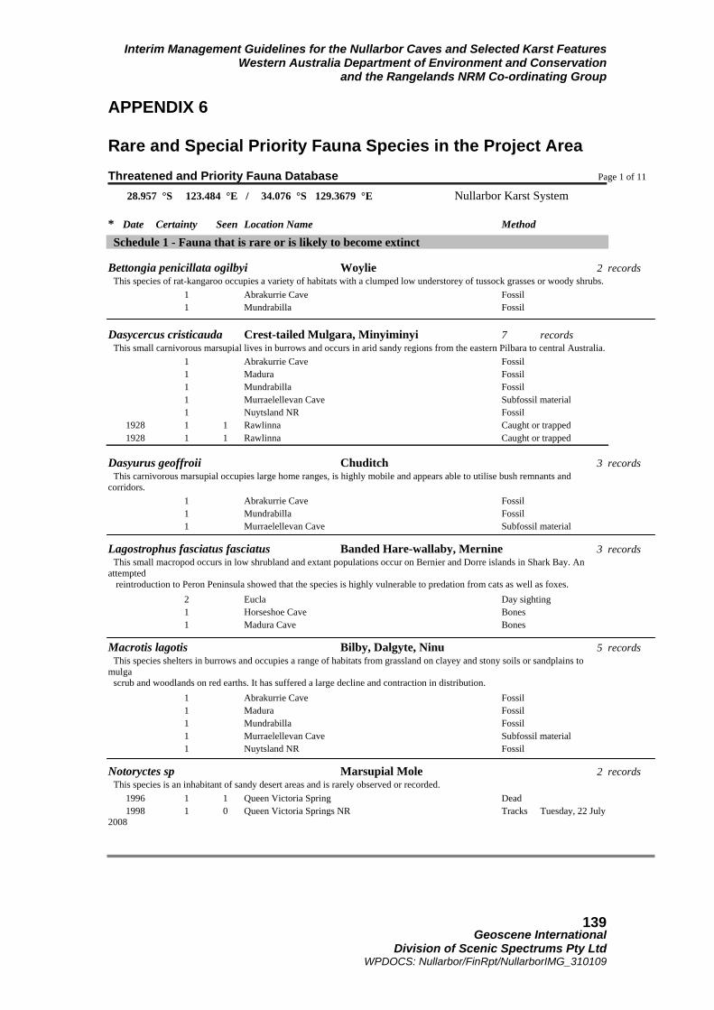
Interim Management Guidelines for the Nullarbor Caves and Selected Karst Features Western Australia Department of Environment and Conservation
and the Rangelands NRM Co-ordinating Group
Geoscene International
Division of Scenic Spectrums Pty Ltd WPDOCS: Nullarbor/FinRpt/NullarborIMG_310109
139
APPENDIX 6 Rare and Special Priority Fauna Species in the Project Area Threatened and Priority Fauna Database Page 1 of 11 28.957 °S 123.484 °E / 34.076 °S 129.3679 °E Nullarbor Karst System
* Date Certainty Seen Location Name Method Schedule 1 - Fauna that is rare or is likely to become extinct
Bettongia penicillata ogilbyi Woylie 2 records This species of rat-kangaroo occupies a variety of habitats with a clumped low understorey of tussock grasses or woody shrubs. 1 Abrakurrie Cave Fossil 1 Mundrabilla Fossil Dasycercus cristicauda Crest-tailed Mulgara, Minyiminyi 7 records This small carnivorous marsupial lives in burrows and occurs in arid sandy regions from the eastern Pilbara to central Australia. 1 Abrakurrie Cave Fossil 1 Madura Fossil 1 Mundrabilla Fossil 1 Murraelellevan Cave Subfossil material 1 Nuytsland NR Fossil 1928 1 1 Rawlinna Caught or trapped 1928 1 1 Rawlinna Caught or trapped
Dasyurus geoffroii Chuditch 3 records This carnivorous marsupial occupies large home ranges, is highly mobile and appears able to utilise bush remnants and corridors. 1 Abrakurrie Cave Fossil 1 Mundrabilla Fossil 1 Murraelellevan Cave Subfossil material
Lagostrophus fasciatus fasciatus Banded Hare-wallaby, Mernine 3 records This small macropod occurs in low shrubland and extant populations occur on Bernier and Dorre islands in Shark Bay. An attempted reintroduction to Peron Peninsula showed that the species is highly vulnerable to predation from cats as well as foxes. 2 Eucla Day sighting 1 Horseshoe Cave Bones 1 Madura Cave Bones
Macrotis lagotis Bilby, Dalgyte, Ninu 5 records This species shelters in burrows and occupies a range of habitats from grassland on clayey and stony soils or sandplains to mulga scrub and woodlands on red earths. It has suffered a large decline and contraction in distribution. 1 Abrakurrie Cave Fossil 1 Madura Fossil 1 Mundrabilla Fossil 1 Murraelellevan Cave Subfossil material 1 Nuytsland NR Fossil
Notoryctes sp Marsupial Mole 2 records This species is an inhabitant of sandy desert areas and is rarely observed or recorded. 1996 1 1 Queen Victoria Spring Dead 1998 1 0 Queen Victoria Springs NR Tracks Tuesday, 22 July 2008

Interim Management Guidelines for the Nullarbor Caves and Selected Karst Features Western Australia Department of Environment and Conservation
and the Rangelands NRM Co-ordinating Group
Geoscene International
Division of Scenic Spectrums Pty Ltd WPDOCS: Nullarbor/FinRpt/NullarborIMG_310109
140
Threatened and Priority Fauna Database Page 2 of 11
28.957 °S 123.484 °E / 34.076 °S 129.3679 °E Nullabor Karst System
* Date Certainty Seen Location Name Method Phascogale calura Red-tailed Phascogale, Kenngoor 3 records This arboreal marsupial seems to prefer dense woodland or tall shrubland with a continuous canopy and is most often associated with dense stands of rock sheoak (Allocasuarina huegeliana) and wandoo (Eucalyptus wandoo). 1 Madura Fossil 1 Mundrabilla Fossil 1 Murraelellevan Cave Subfossil material
Pseudocheirus occidentalis Western Ringtail Possum 1 records This species occurs in areas of forest and dense woodlands and requires tree hollows and/or dense canopy for refuge and nesting. 1 Mundrabilla Fossil
Sminthopsis psammophila Sandhill Dunnart 16 records This small insectivorous marsupial inhabits areas with sandy soils and an understorey of hummock grass. 1 Queen Victoria Springs NR 1985 1 1 Great Victoria Desert Caught or trapped 1985 1 2 Great Victorian Desert Caught or trapped 1985 1 1 Great Victorian Desert Caught or trapped 1985 1 1 Great Victorian Desert Caught or trapped 1988 1 5 Queen Victoria Springs NR Caught or trapped 2001 1 2 Great Victoria Desert Caught or trapped 2001 1 1 Great Victoria Desert Caught or trapped 2001 1 1 Great Victoria Desert Caught or trapped 2001 1 1 Great Victoria Desert Caught or trapped 2001 1 1 Great Victoria Desert Caught or trapped 2001 1 1 Great Victoria Desert Caught or trapped 2005 1 1 Great Victoria Desert Caught or trapped 2005 1 1 Great Victoria Desert Caught or trapped 2006 1 1 Great Victoria Desert Caught or trapped 2007 1 1 Great Victoria Desert Caught or trapped
Leporillus conditor Greater Stick-nest Rat, Wopilkara 5 records This species is presumed extinct in the wild on the mainland but old stick nests remain in small caves and under ledges in breakaways and gorges. 1 Abrakurrie Cave Fossil 1 Madura Fossil 1 Mundrabilla Fossil 1 Murraelellevan Cave Subfossil material 1 Nuytsland NR Fossil
Pseudomys australis Plains Rat 1 records 1 Nullarbor Plain
Pseudomys fieldi Shark Bay Mouse, Djoongari 5 records Tuesday, 22 July 2008

Interim Management Guidelines for the Nullarbor Caves and Selected Karst Features Western Australia Department of Environment and Conservation
and the Rangelands NRM Co-ordinating Group
Geoscene International
Division of Scenic Spectrums Pty Ltd WPDOCS: Nullarbor/FinRpt/NullarborIMG_310109
141
Threatened and Priority Fauna Database Page 3 of 11
28.957 °S 123.484 °E / 34.076 °S 129.3679 °E Nullabor Karst System * Date Certainty Seen Location Name Method
1 Abrakurrie Cave Fossil 1 Madura Fossil 1 Mundrabilla Fossil 1 Murraelellevan Cave Subfossil material 1 Nuytsland NR Fossil Eubalaena australis Southern Right Whale 9 records 1984 1 1 1984 1 1994 1 27 Israelite Bay Day sighting 1999 1 104 Israelite Bay Day sighting 1999 1 19 Twilight Bay Day sighting 2000 1 17 Twilight Cove Day sighting 2000 1 51 Israelite Bay Day sighting 2000 1 16 Twilight Bay Day sighting 2000 1 22 Twilight Cove Day sighting
Macronectes giganteus Southern Giant Petrel 1 records 2005 1 1 Cocklebiddy Dead
Phoebetria fuscaSooty Albatross 1 records This species is an occasional visitor to the WA coast. It breeds on islands in the southern Indian and Atlantic oceans. 1984 1 1 Nuytsland NR Dead
Thalassarche carteri Indian Yellow-nosed Albatross 1 records 1999 1 13 Nuytsland Nature Reserve Day sighting
Thalassarche chlororhynchos Atlantic Yellow-nosed Albatross 3 records This species is an occasional visitor to the WA coast. It breeds on islands in the southern Indian and Atlantic oceans. 1978 2 33 Israelite Bay Dead 1984 2 1 Eucla Dead 1984 2 35 Israelite Bay Day sighting Leipoa ocellataMalleefowl 10 records This species was once widely distributed across southern Australia. It prefers woodland or shrubland with an abundant litter layer that provides essential material for the construction of its nest mound. 1964 1 Kanandah 1976 1 Mundrabilla Day sighting 1977 1 Ponton Creek 1984 1 Madura 1984 1 Nuytsland NR 1984 1 Nuytsland NR 1999 1 1 Nuytsland Nature Reserve Day sighting
Tuesday, 22 July 2008

Interim Management Guidelines for the Nullarbor Caves and Selected Karst Features Western Australia Department of Environment and Conservation
and the Rangelands NRM Co-ordinating Group
Geoscene International
Division of Scenic Spectrums Pty Ltd WPDOCS: Nullarbor/FinRpt/NullarborIMG_310109
142
Threatened and Priority Fauna Database Page 4 of 11
28.957 °S 123.484 °E / 34.076 °S 129.3679 °E Nullabor Karst System
* Date Certainty Seen Location Name Method 2006 1 1 Cocklebiddy Day sighting 2007 1 1 Plumridge Lakes Day sighting 2007 1 0 Plumridge Lakes NR Definite signs
Pezoporus wallicus flaviventrus Western Ground Parrot 3 records This species is rare and patchily distributed along the south coastal area from Denmark to Cape Arid where it inhabits low dense shrublands. 2003 1 1 Nuytsland NR Day sighting 2005 1 0 Nuytsland NR Day sighting 2005 1 0 Nuytsland NR Heard
Caretta caretta Loggerhead Turtle 1 records This species of marine turtle has been recorded at numerous locations along the WA coast. 1999 3 1 Nuytsland NR
Abelaioscia troglodytes Pannikin Plains Cave Isopod 1 records 1900 1 1 Nuytsland NR
Tartarus mullamullangensis Mullamullang Cave Spider 1 records This species is known only from Mullamullang Cave. 1969 1 3
Tartarus murdochensis Murdoch Sink Cave Spider 2 records 1985 1 2 1985 1 2 Cocklebiddy
Tartarus nurinensis Nurina Cave Spider 1 records This species is known only from Nurina Cave. 1985 1 1 Caught or trapped
Tartarus thampannensis Thampanna Cave Spider 1 records 1985 1 1
Troglodiplura lowryi 10 Nullarbor Cave Trapdoor Spider 2 records This species is known only from Nullarbor Cave. 1966 1 1 1990 1 2 Forrest
NOTE 10: Living specimens of Troglodiplura lowryi have been discovered in Unnamed Caves 6N-327, 6N-1327, 6N-1369 and other caves of the Madura and Mundrabilla areas of the Nullarbor Karst Region (Norman Poulter OAM, Pers. Com., 2008).

Interim Management Guidelines for the Nullarbor Caves and Selected Karst Features Western Australia Department of Environment and Conservation
and the Rangelands NRM Co-ordinating Group
Geoscene International
Division of Scenic Spectrums Pty Ltd WPDOCS: Nullarbor/FinRpt/NullarborIMG_310109
143
Schedule 2 - Presumed extinct
Bettongia pusilla Nullarbor Dwarf Bettong 1 records 1 Old Homestead Cave Subfossil material Tuesday, 22 July 2008 Threatened and Priority Fauna Database Page 5 of 11
28.957 °S 123.484 °E / 34.076 °S 129.3679 °E Nullarbor Karst System
* Date Certainty Seen Location Name Method Chaeropus ecaudatus Pig-footed Bandicoot, Kantjilpa 1 records 1927 1 1 Dead
Onychogalea lunata Crescent Nailtail Wallaby 1 records 1 Madura Cave Fossil
Potorous platyops Broad-faced Potoroo 1 records 1 Mundrabilla Fossil
Leporillus apicalis Lesser Stick-nest Rat 4 records This species is presumed extinct but old stick nests remain in small caves and under ledges in breakaways and gorges. 1 Abrakurrie Cave Fossil 1 Madura Fossil 1 Mundrabilla Fossil 1 Murraelellevan Cave Subfossil material Schedule 4 - Other specially protected fauna
Arctocephalus forsteri New Zealand Fur-seal 3 records 1991 1 133 Recherche Archipelago NR Day sighting 1991 1 42 Recherche Archipelago NR Day sighting 1991 1 113 Recherche Archipelago NR Day sighting
Neophoca cinerea Australian Sea-lion 12 records 1 0 Recherche Archipelago NR 1990 1 5 Recherche Archipelago NR Day sighting 1990 1 56 Recherche Archipelago NR Day sighting 1990 1 48 Recherche Archipelago NR Day sighting 1990 1 84 Recherche Archipelago NR Day sighting 1991 1 35 Recherche Archipelago NR Day sighting 1991 1 44 Recherche Archipelago NR Day sighting 1991 1 55 Recherche Archipelago NR Day sighting 1991 1 10 Recherche Archipelago NR Day sighting 1991 1 62 Recherche Archipelago NR Day sighting 1991 1 63 Recherche Archipelago NR Day sighting 1996 1 28 Day sighting
Falco peregrinus Peregrine Falcon 5 records This species is uncommon and prefers areas with rocky ledges, cliffs, watercourses, open woodland or margins with cleared

Interim Management Guidelines for the Nullarbor Caves and Selected Karst Features Western Australia Department of Environment and Conservation
and the Rangelands NRM Co-ordinating Group
Geoscene International
Division of Scenic Spectrums Pty Ltd WPDOCS: Nullarbor/FinRpt/NullarborIMG_310109
144
land. 1961 1 1 Day sighting
Tuesday, 22 July 2008 Threatened and Priority Fauna Database Page 6 of 11
28.957 °S 123.484 °E / 34.076 °S 129.3679 °E Nullarbor Karst System
* Date Certainty Seen Location Name Method 1974 1 1 Haig Day sighting 1975 1 Nuytsland NR Day sighting 1984 1 Mundrabilla 2006 1 1 Cocklebiddy Day sighting
Cacatua leadbeateri Major Mitchell's Cockatoo 20 records This species is sporadically distributed through arid and semi-arid Australia and may occur in sparsely timbered grasslands and shrublands and rocky outcrops. 1908 1 2 Day sighting 1908 1 2 Queen Victoria Spring NR Day sighting 1972 1 Carlisle Lakes Dead 1973 1 70 Nuytsland NR Day sighting 1975 1 Nuytsland NR Day sighting 1976 1 0 Nuytsland NR Heard 1976 1 Nuytsland NR Day sighting 1977 1 3 Wanteen Day sighting 1978 1 1 Mundrabilla Day sighting 1982 1 62 Eucla Day sighting 1983 1 3 Mundrabilla Day sighting 1984 1 Madura 1984 1 Mundrabilla 1984 1 Mundrabilla 1984 1 Nuytsland NR 1984 1 Nuytsland NR 1984 1 Nuytsland NR 1985 1 70 Madura Day sighting 1991 1 60 Madura Day sighting 2003 1 100 Nuytsland NR
Northiella haematogaster narethae Naretha Blue Bonnet 42 records This species of parrot is an inhabitant of lightly wooded plains on the periphery of the Nullarbor Plain. 1974 1 8 Rawlinna Day sighting 1974 1 4 Naretha Day sighting 1978 1 1 Kanandah Day sighting 1978 1 10 Naretha Day sighting 1978 1 2 Seemore Downs Day sighting 1978 3 0 Kanandah Definite signs 1978 3 0 Kanandah Definite signs 1978 3 0 Kanandah Definite signs 1978 3 0 Kanandah Definite signs 1978 3 0 Kanandah Definite signs 1978 3 0 Kanandah Definite signs 1978 3 0 Kanandah Definite signs 1978 3 0 Kanandah Definite signs 1978 3 0 Kanandah Definite signs Tuesday, 22 July 2008

Interim Management Guidelines for the Nullarbor Caves and Selected Karst Features Western Australia Department of Environment and Conservation
and the Rangelands NRM Co-ordinating Group
Geoscene International
Division of Scenic Spectrums Pty Ltd WPDOCS: Nullarbor/FinRpt/NullarborIMG_310109
145
Threatened and Priority Fauna Database Page 7 of 11
28.957 °S 123.484 °E / 34.076 °S 129.3679 °E Nullabor Karst System
* Date Certainty Seen Location Name Method 1978 3 0 Rawlinna Definite signs 1978 3 0 Rawlinna Definite signs 1978 3 0 Rawlinna Definite signs 1980 1 12 Seemore Downs Day sighting 1981 1 25 Kanandah Day sighting 1981 1 Rawlinna Day sighting 1982 1 10 Mundrabilla Day sighting 1983 1 Kanandah Day sighting 1983 1 10 Naretha Day sighting 1983 1 8 Plumridge Lakes Day sighting 1983 1 Seemore Downs Day sighting 1984 1 7 Caiguna Day sighting 1984 1 Great Victorian Desert NR 1984 1 Great Victorian Desert NR 1984 1 Great Victorian Desert NR 1984 1 Great Victorian Desert NR 1984 1 Loongana 1984 1 Mundrabilla Motel 1984 1 Plumridge Lakes 1984 1 Plumridge Lakes NR 1984 1 18 Plumridge Lakes NR Day sighting 1985 1 50 Naretha Day sighting 1985 1 Kanandah Day sighting 1985 1 Kanandah Day sighting 1986 1 12 Great Victorian Desert NR Day sighting 1997 6 Kanandah Day sighting 1999 1 7 Cocklebiddy Day sighting 1999 1 2 Zanthus Day sighting
Priority One: Taxa with few, poorly known populations on threatened lands
Aspidites ramsayi Woma (southwest pop) 2 records A nocturnal species of python restricted to arid areas. 1992 1 1 Zanthus Day sighting 1996 1 1 Zanthus Caught or trapped
Branchinella basispina 1 records 1975 1 Balladonia Caught or trapped
Priority Two: Taxa with few, poorly known populations on conservation lands
Lerista puncticauda 1 records 1988 1 4 Queen Victoria Spring Caught or trapped
Tuesday, 22 July 2008

Interim Management Guidelines for the Nullarbor Caves and Selected Karst Features Western Australia Department of Environment and Conservation
and the Rangelands NRM Co-ordinating Group
Geoscene International
Division of Scenic Spectrums Pty Ltd WPDOCS: Nullarbor/FinRpt/NullarborIMG_310109
146
Threatened and Priority Fauna Database Page 8 of 11
28.957 °S 123.484 °E / 34.076 °S 129.3679 °E Nullabor Karst System
* Date Certainty Seen Location Name Method Priority Four: Taxa in need of monitoring
Nyctophilus timoriensis (central form) Central Long-eared Bat 1 records This species of bat roosts in tree hollows and under loose bark but little else is known about this species. 1984 1 Balladonia Caught or trapped
Pseudomys occidentalis Western Mouse 3 records This species occurs most frequently in areas of long-unburnt vegetation on sandy clay or loam with a matrix of gravel. It is known to feed on the seeds of quandong (Santalum acuminatum) and various sedge species. 1 Mundrabilla Fossil 1 Murraelellevan Cave Subfossil material 1 Nuytsland NR Fossil
Physeter macrocephalus Sperm Whale 3 records 1946 1 Sheoaks Hill Dead 1983 1 1 Israelite Bay Dead 1984 1 1 Israelite Bay Dead
Falco hypoleucos Grey Falcon 4 records A nomadic species inhabiting lightly timbered riverine plains. 1950 1 1 Nuytsland Nature Reserve Day sighting 1968 1 2 Sleeper Camp Day sighting 1992 1 1 Plumridge Lakes NR Day sighting 1993 1 5 Day sighting
Ardeotis australis Australian Bustard 20 records This species is uncommon and may occur in open or lightly wooded grasslands. 1967 1 3 Nuytsland NR Day sighting 1969 1 Carlisle Lakes Day sighting 1969 1 Lake Brown Day sighting 1970 1 Lake Brown Day sighting 1974 1 2 Rawlinna Day sighting 1976 1 1 Kanandah Day sighting 1976 1 2 Kanandah Day sighting 1980 1 2 Boonderoo Day sighting 1981 1 2 Arubiddy Day sighting 1981 1 35 Arubiddy Day sighting 1981 1 Kanandah Day sighting 1981 1 3 Rawlinna Day sighting 1982 1 1 Cocklebiddy Day sighting 1983 1 6 Booanya Day sighting 1983 1 2 Naretha Day sighting 1983 1 1 Plumridge Lakes Day sighting 1983 1 6 Seemore Downs Day sighting
Tuesday, 22 July 2008

Interim Management Guidelines for the Nullarbor Caves and Selected Karst Features Western Australia Department of Environment and Conservation
and the Rangelands NRM Co-ordinating Group
Geoscene International
Division of Scenic Spectrums Pty Ltd WPDOCS: Nullarbor/FinRpt/NullarborIMG_310109
147
Threatened and Priority Fauna Database Page 9 of 11
28.957 °S 123.484 °E / 34.076 °S 129.3679 °E Nullabor Karst System
* Date Certainty Seen Location Name Method 1984 Queen Victoria Springs NR Day sighting 1984 1 Plumridge Lakes NR Day sighting 1984 1 2 Cocklebiddy Day sighting
Charadrius rubricollis Hooded Plover 1 records This species frequents the margins and shallows of salt lakes, also along coastal beaches, where it forages for invertebrates along the water's edge. 1996 1 36 Nuytsland Nature Reserve Day sighting
Polytelis alexandraePrincess Parrot 1 records Little is known about this species as its occurrence is sporadic through the arid interior. Occurs on red desert sandplains and dunes and along tree-lined watercourses. 1983 2 15 Queen Victoria Springs NR Day sighting
Amytornis textilis textilis Thick-billed Grass-wren (western ssp) 5 records This species inhabits shrubland, preferring the denser vegetation along drainage depressions. 1984 1 Haig 1984 1 Haig 1984 1 Haig 1984 1 Haig 1984 1 Haig
Cinclosoma alisteri Nullarbor Quail-thrush 65 records A shy, uncommon bird species that inhabits low sparse vegetation such as saltbush shrublands. 1 Forrest 1921 1 1 Caught or trapped 1921 1 1 Day sighting 1922 1 1 Caught or trapped 1942 1 3 Caught or trapped 1954 1 1 Forrest Day sighting 1966 1 2 Day sighting 1968 1 3 Caught or trapped 1969 1 3 Caught or trapped 1969 1 1 Caught or trapped 1969 1 1 Caught or trapped 1969 1 1 Day sighting 1969 1 1 Caught or trapped 1970 1 1 Caught or trapped 1974 1 2 Day sighting 1974 1 3 Day sighting 1979 1 1 Cocklebiddy Day sighting 1980 1 1 Cocklebiddy Caught or trapped 1980 1 1 Day sighting 1980 1 1 Day sighting 1980 1 1 Cocklebiddy Day sighting 1981 1 1 Day sighting
Tuesday, 22 July 2008

Interim Management Guidelines for the Nullarbor Caves and Selected Karst Features Western Australia Department of Environment and Conservation
and the Rangelands NRM Co-ordinating Group
Geoscene International
Division of Scenic Spectrums Pty Ltd WPDOCS: Nullarbor/FinRpt/NullarborIMG_310109
148
Threatened and Priority Fauna Database Page 10 of 11
28.957 °S 123.484 °E / 34.076 °S 129.3679 °E Nullarbor Karst System
* Date Certainty Seen Location Name Method
1981 1 1 Day sighting 1982 1 7 Aurbiddy Night sighting 1982 1 1 Day sighting 1983 1 1 Day sighting 1983 1 1 Forrest Day sighting 1984 1 2 Day sighting 1986 1 1 Day sighting 1986 1 1 Forrest Day sighting 1986 1 1 Forrest Day sighting 1987 1 1 Day sighting 1987 1 1 Day sighting 1987 1 1 Caught or trapped 1991 1 1 Day sighting 1991 1 5 Day sighting 1991 1 1 Day sighting 1991 1 4 Day sighting 1991 1 3 Day sighting 1991 1 1 Day sighting 1991 1 1 Day sighting 1991 1 2 Day sighting 1991 1 1 Day sighting 1991 1 2 Day sighting 1991 1 1 Cocklebiddy Day sighting 1991 1 3 Cocklebiddy Day sighting 1992 1 3 Day sighting 1992 1 1 Day sighting 1992 1 3 Day sighting 1992 1 3 Day sighting 1992 1 1 Day sighting 1992 1 1 Day sighting 1992 1 1 Day sighting 1992 1 1 Day sighting 1992 1 1 Day sighting 1992 1 2 Day sighting 1992 1 7 Forrest Day sighting 1992 1 2 Forrest Day sighting 1992 1 1 Day sighting 1992 1 2 Forrest Day sighting 1992 1 1 Forrest Day sighting 1993 1 1 Day sighting 1997 1 1 Forrest Day sighting 1999 1 2 Day sighting 1999 1 2 Day sighting
Tuesday, 22 July 2008

Interim Management Guidelines for the Nullarbor Caves and Selected Karst Features Western Australia Department of Environment and Conservation
and the Rangelands NRM Co-ordinating Group
Geoscene International
Division of Scenic Spectrums Pty Ltd WPDOCS: Nullarbor/FinRpt/NullarborIMG_310109
149
Threatened and Priority Fauna Database Page 11 of 11
28.957 °S 123.484 °E / 34.076 °S 129.3679 °E Nullarbor Karst System
* Date Certainty Seen Location Name Method
Falcunculus frontatus leucogaster Crested Shrike-tit (south-western ssp) 1 records This species is an uncommon inhabitant of woodlands. 1908 1 2 Zanthus Day sighting
Oreoica gutturalis gutturalis Crested Bellbird (southern) 5 records This sedentary and solitary species inhabits the drier mallee woodlands and heaths of the southern parts of the State. 1978 1 1 Boonderoo Day sighting 1981 1 Kanandah Day sighting 1981 1 Seemore Downs Day sighting 1983 1 1 Plumridge Lakes Day sighting 1983 1 2 Zanthus Day sighting
Pomatostomus superciliosus ashbyi White-browed Babbler (western 1 records This species of bird lives in eucalypt forests and woodlands, and forages on or near the ground for insects and seeds. 2003 1 Nuytsland NR
Priority Five: Taxa in need of monitoring (conservation dependent)
Isoodon obesulus fusciventer Quenda 1 records This species prefers areas with dense understorey vegetation, particularly around swamps and along watercourses, that provides ample protection from predators. 1 Recherche Archipelago NR
* Information relating to any records provided for listed species:- Date: date of recorded observation Certainty (of correct species identification): 1=Very certain; 2=Moderately certain; and 3=Not sure. Seen: Number of individuals observed. Location Name: Name of reserve or nearest locality where observation was made Method: Method or type of observation Tuesday, 22 July 2008
Tuesday, 22 July 2008 (Source: Dept. of Environment and Conservation, July 2008)

Interim Management Guidelines for the Nullarbor Caves and Selected Karst Features Western Australia Department of Environment and Conservation
and the Rangelands NRM Co-ordinating Group
Geoscene International
Division of Scenic Spectrums Pty Ltd WPDOCS: Nullarbor/FinRpt/NullarborIMG_310109
150
APPENDIX 7 Scenic Resource Frame of Reference Assessment Criteria for Nullarbor Features of High or Moderate Scenic Quality
(Source: Dept. of Conservation and Land Management, 1994. Reading the Remote: Landscape Characters of Western Australia.)
Nullarbor Plain Sub Type Visual Quality Classification – Frame of Reference
SCENIC QUALITY
LANDFORM VEGETATION WATERFORM
HIGH *Rounded clay filled depressions or dongas. *Distinctive low elongated parallel crests and corridor depressions. *Irregular coastline edges and steep vertical cliffs, e.g. Baxter Cliffs. *Irregular coastline edges and steep vertical cliffs, e.g. Baxter Cliffs. *Steeply sloping terrain of distinctive shape and abrupt appearance, e.g. Hampton Scarp. *Wind formed dunes of distinctive form which become focal points, e.g. Eucla National Park. *Coastal dunes which display areas of active weathering and abrupt edge transition to adjacent low-lying areas, e.g. Twilight Bay.
* Wind shaped, gnarled or dwarfed vegetation which create unique forms colours or textures, e.g. Banksia epica. *Stands of vegetation which display unusual form, colour or texture in comparison to surrounding vegetation and contrasting with the adjacent landscape, e.g. taller vegetation in dongas. *Ephemerals showing striking display of colours, shapes and textures, e.g. Sturt Desert Peas.
*Any evidence of lakes, clay pans or pooled water, filled or dry, e.g. Forrest Lakes.
MODERATE *Dunal formation of uniform height and shape *Features which are not visually dominant and are surrounded by similar landforms. *Regular coastline edges with little contrast in form, texture and colour.
*Vegetation which displays the size, form, colour, texture and spacing found commonly in the surrounding landscape.
*Waterforms where present, rate no lower than high in this LCT.
The extensive, expansive and monotonous topographic and vegetative visual attributes of this Visual Landscape Character Sub Type is of special scenic interest and rate no lower than Moderate Scenic Quality.

Interim Management Guidelines for the Nullarbor Caves and Selected Karst Features Western Australia Department of Environment and Conservation
and the Rangelands NRM Co-ordinating Group
Geoscene International
Division of Scenic Spectrums Pty Ltd WPDOCS: Nullarbor/FinRpt/NullarborIMG_b_310109
151
APPENDIX 8 CEGSA Cave Prioritisation or Vulnerability Table (Source: Cave Exploration Group (South Australia) Inc., 2008. Refer to Tables 5 and 6 in main text of this report for the associated CEGSA Overall Risk Level Assessment Matrix for Caves and the CEGSA Advice Relative to the Overall Cave Risk Levels.)

Interim Management Guidelines for the Nullarbor Caves and Selected Karst Features Western Australia Department of Environment and Conservation
and the Rangelands NRM Co-ordinating Group
Geoscene International
Division of Scenic Spectrums Pty Ltd WPDOCS: Nullarbor/FinRpt/NullarborIMG_b_310109
152

Interim Management Guidelines for the Nullarbor Caves and Selected Karst Features Western Australia Department of Environment and Conservation
and the Rangelands NRM Co-ordinating Group
Geoscene International
Division of Scenic Spectrums Pty Ltd WPDOCS: Nullarbor/FinRpt/NullarborIMG_b_310109
153

Interim Management Guidelines for the Nullarbor Caves and Selected Karst Features Western Australia Department of Environment and Conservation
and the Rangelands NRM Co-ordinating Group
Geoscene International
Division of Scenic Spectrums Pty Ltd WPDOCS: Nullarbor/FinRpt/NullarborIMG_b_310109
154

Interim Management Guidelines for the Nullarbor Caves and Selected Karst Features Western Australia Department of Environment and Conservation
and the Rangelands NRM Co-ordinating Group
Geoscene International
Division of Scenic Spectrums Pty Ltd WPDOCS: Nullarbor/FinRpt/NullarborIMG_b_310109
155
APPENDIX 9 Enhanced Management Frameworks The highly dispersed nature of the caves and associated karst features of the project area, combined with the various land tenures and management vestings involved are an indication that at a preliminary level, it may be useful for the Nullarbor Cave and Karst Management Advisory Committee to be formed with broader representation or to investigate the appropriateness of forming some other regional management body that will provide for more of the key stakeholders and vested management authorities to be involved in joint decision-making and co-management regarding future land use and conservation management in the region, particularly regarding caves, blowholes and dolines. Following on from the 2002 Biodiversity Audit recommendations and those of Subterranean Ecology (2007) and previously by Davey et. al. (1992), continuing examination of how caves and karst features might best be protected and conserved should be carried out over the next five years. Whether these resources are managed within a CAR Reserve System, the Conservation Estate or in other protective management agreements with Pastoral Leaseholders and Freehold land owners of the Nullarbor, it will be important to assess and prioritise the caves, blowholes and dolines for inclusion under various land tenure and management framework categories. Along with this, consideration may also be given to the various levels or forms of protected area management, given the high significance and vulnerability of the Nullarbor karst. While assuming the retention of the current land tenure arrangements, these framework categories could possibly include:
• a regional management authority; • a UNESCO Man and the Biosphere Programme “Biosphere Reserve”; • a World Conservation Union (IUCN) “Indigenous Protected Area”; • a UNESCO “Geopark” (Global Geoparks Network); or • a UNESCO (World Heritage Commission) World Heritage Site.
All of these categories for protected areas could be established while maintaining and including the existing Pastoral leaseholds on the Nullarbor. However, within the IUCN Protected Area Management Categories, only Category VI - Managed Resource Protected Area, would seem to allow for pastoral uses. This category is also used, but not generally funded, under Australia’s National Reserve System Program.
Further Websites and Links on Potential Protected Area Alternatives:
• Australia’s National Reserve System (NRS) Program http://www.unep-wcmc.org/protected_areas/index.html
• UNESCO “Biosphere Reserves” http://www.unesco.org/mab/BRs.shtml http://www.environment.gov.au/parks/biosphere/index.html Video on Biosphere Reserves
• IUCN “Indigenous Protected Area” or “Indigenous Conservation Territory” http://www.environment.gov.au/indigenous/ipa/index.html http://cms.iucn.org/what/issues/issues/index.cfm?uNewsID=11
• UNESCO “Geopark” http://www.unesco.org/science/earth/geoparks.shtml
• UNESCO (World Heritage Commission) World Heritage Sites Australian National Commission for UNESCO UNESCO World Heritage
• IUCN, WCPA and Australia’s NRS Protected Area Management Categories http://www.environment.gov.au/parks/iucn.html IUCN (World Conservation Union ) http://www.unep-wcmc.org/protected_areas/index.html http://cms.iucn.org/about/union/commissions/wcpa/wcpa_overview/index.cfm
End of Appendices Section and Report