integrating land use planning and biodiversityland use, to examine the interaction of biodiversity,...
TRANSCRIPT


ACKNOWLEDGEMENTSWe wish to thank all of the participants in the workshop for their valuable contributions before,during and after the workshop. Mark Shaffer, senior vice president for program, Laura Watchman,vice president for habitat conservation, and Sara Vickerman, director west coast office of Defendersof Wildlife provided guidance in the creation of the workshop and this report. Tim Mealey, seniorpartner at Meridian Institute served as an effective facilitator at the workshop. Chuck Huckelberry,Pima County Administrator, and Sharon McGregor, Massachusetts Executive Office of EnvironmentalAffairs, both gave excellent overview presentations of their planning projects at the workshop.Marc Bonta, Lisa Hummon, Inga Sedlovsky, and Chapman Stewart of Defenders of Wildlife helpedwith logistics for the workshop. Kathie Cowell and Mitzi Wallace at the Aspen Wye River ConferenceCenter were extremely helpful in arranging the workshop. Maeveen Behan, Pima County, Arizona,and Jessica Patalano, Massachusetts Natural Heritage Program, provided map graphics for the report.The authors especially wish to acknowledge Kassandra Stirling, media production specialist withDefenders' west coast office for bringing the final report together. Any errors or misrepresentationsof the various planning efforts described here are ultimately the fault of the authors.
AuthorsJeffrey P. Cohn, writer, Takoma Park, MarylandJeffrey A. Lerner, Conservation Planning Associate, Defenders of Wildlife
EditorElizabeth Grossman, writer, Portland, Oregon
Project ManagerJeffrey A. Lerner, Conservation Planning Associate, Defenders of Wildlife
ProductionLisa Hummon, Habitat Program Coordinator, Defenders of WildlifeKassandra Stirling, Media Production Specialist, Defenders of Wildlife
DesignerManda Beckett, Claritas Consortium, Portland, Oregon
Maps provided byOregon Biodiversity Project, West Linn, Oregon; Defenders of Wildlife, Washington D.C.;Willamette Restoration Initiative, Salem, Oregon; Sonoran Desert Conservation Plan,Pima County, Arizona; The BioMap Project, Westborough, Massachusetts.
Additional copies of this report may be downloaded from the Biodiversity Partnership website at www.biodiversitypartners.org
Copyright © 2003 by Defenders of Wildlife, 1101 Fourteenth Street, NW, Suite 1400, Washington, D.C. 20005All rights reserved. Abstracting is permitted with credit to the source.
Printed on recycled paper

INTEGRATING
LAND USE
PLANNING &
BIODIVERSITY
DEFENDERS OF WILDLIFEWASHINGTON D.C.

TABLE OF CONTENTS
EEXXEECCUUTTIIVVEE SSUUMMMMAARRYY .. .. .. 77
IINNTTRROODDUUCCTTIIOONN .. .. .. 99Biodiversity at RiskNeed for Conservation PlanningPromoting Comprehensive Conservation Planning
CCOONNSSEERRVVAATTIIOONN PPLLAANNSS IINN PPRROOGGRREESSSS .. .. .. 1155Massachusetts BioMapSonoran Desert Conservation PlanOregon Biodiversity ProjectWillamette Restoration Initiative
WWOORRKKSSHHOOPP DDIISSCCUUSSSSIIOONN .. .. .. 1177Benefits of Adopting Conservation Planning Barriers To Using Conservation Planning at the Local LevelRecommendations for Creating State and Regional Conservation Plans Recommendations For Integrating Regional Conservation Plans into Local PlanningThe Role of Conservation Organizations
CCOONNCCLLUUSSIIOONNSS .. .. .. 2255
CCOONNSSEERRVVAATTIIOONN PPLLAANNNNIINNGG MMAAPPSS .. .. .. 2277
AAPPPPEENNDDIIXX AA:: PPRROOJJEECCTT DDEESSCCRRIIPPTTIIOONNSS .. .. .. 3333
II.. SSTTAATTEEWWIIDDEE PPLLAANNSS .. .. .. 33331. Oregon Biodiversity Plan, Oregon; West Eugene Wetlands, Oregon2. Florida Closing the Gaps Project; Florida Ecological Network3. Maryland Green Infrastructure and GreenPrint Program; Baltimore Greenways, Maryland4. New Jersey Landscape Project; New Jersey Pine Barrens5. Massachusetts BioMap6. Washington State Growth Management and Ecoregional Conservation
IIII.. RREEGGIIOONNAALL MMUULLTTII--SSPPEECCIIEESS HHAABBIITTAATT CCOONNSSEERRVVAATTIIOONN PPLLAANNSS .. .. .. 44661. Sonoran Desert Conservation Plan, Pima County, Arizona2. Southern California Habitat Conservation Plans 3. Placer Legacy Open Space and Agricultural Conservation Program4. Multi-Species Habitat Conservation Plan, Clark County, Nevada
IIIIII.. RREEGGIIOONNAALL PPLLAANNSS .. .. .. 55221. Chicago Wilderness2. Metropolitan Conservation Alliance3. "Beginning with Habitat" Program, Southern Maine4. Minnesota Metro Greenways5. Albemarle County, Virginia6. The Partnership Land Use System, Larimer County, Colorado
AAPPPPEENNDDIIXX BB:: CCOONNSSEERRVVAATTIIOONN PPLLAANNNNIINNGG CCOONNTTAACCTTSS .. .. .. 5588
AAPPPPEENNDDIIXX CC:: WWOORRKKSSHHOOPP PPAARRTTIICCIIPPAANNTTSS .. .. .. 6600
LLIITTEERRAATTUURREE CCIITTEEDD .. .. .. 6611

prawl now has such a large and permanentimpact on every aspect of the landscape that to achievetheir goals for wildlife and ecosystem protection, conser-vationists must become involved in land use planning.Development is encroaching on parks and protectedareas. For every new acre protected, many more are lostto poorly planned development. The Natural ResourcesInventory estimates that in the United States, 2.2 millionacres are now being converted to development each year.Roads have an ecological impact on an estimated 20 per-cent of the U.S. landscape. Of the 6,700 species in theU.S. considered at risk of extinction, 85 percent sufferprimarily from habitat loss. Although federal wildlifeagencies list only approximately 1,300 of these speciesunder the Endangered Species Act, implementing the actremains controversial. If such ecological problems are tobe solved, conservationists and land use planners mustwork together. Yet how can the planning communitymake use of the vast quantity of available conservationinformation and the tools of their trade to improve theprospects for the preservation of biodiversity?
Land use planning occurs at many different scales acrossthe country. At its best, it is progressive, democratic,timely and responsive to change. When it works, commu-nities thrive and enjoy a high quality of life. When landuse planning fails, communities struggle for years withthe consequences. Many planners understand the
importance of the natural environment to their communi-ties' quality of life, and realize that their decisions canaffect human society and wildlife habitats far into thefuture. Despite this understanding and land use planning'sinfluence on the landscape, conservationists have tradi-tionally made little use of the local planning process inworking toward biodiversity protection.
With funding from the Doris Duke CharitableFoundation, Defenders of Wildlife brought together landuse planners and conservationists from around the coun-try at a workshop held in the spring of 2002. The work-shop's goal was to begin a national dialogue about theintegration of biodiversity and land use planning. Thisreport attempts to summarize that discussion and drawattention to the numerous fledgling efforts at conserva-tion planning currently underway in communitiesthroughout the country.
The workshop emphasized large-scale conservation plan-ning: the networks of conservation lands that are beingplanned at state and regional levels across the country.Ideally, this approach will help preserve the country'srich biodiversity by protecting its most viable habitatsand species populations. This strategy represents currenttheories on the application of conservation biology principles to wildlife preservation, and is conservationbiologists' recommendation for curtailing loss of habitat
EXECUTIVE SUMMARY
7

and biodiversity. Workshop organizers felt it was crucialto understand how local land use planners view suchplans.
Among the messages repeated at the workshop was thatexisting land use planning tools can be used to protectbiodiversity. The conservation plans presented at theworkshop showed how a variety of incentive-based pro-grams and regulations can be applied locally to protectbiodiversity. These presentations also indicated that plan-ners can and do make efforts to assemble networks ofconservation lands but that land acquisition — by conser-vation organizations and/or federal agencies — is not theonly solution to protecting lands of conservation value.
The lack of political will among community leaders can,however, hamper planners' efforts to use conservationinformation or make creative use of planning tools.Developing political support for biodiversity protectionmay be one of the more significant hurdles for large-scale conservation planning efforts to overcome. Plannersare not the only people with whom conservationists needto communicate effectively. Members of local planningboards and commissions are tremendously influential,and must be educated and kept informed about conservation issues.
Planners at the workshop were quick to point out thatconservation planning exercises cannot take place in
isolation. Property owners, government agencies and spe-cial interest groups will all want to be involved in mak-ing decisions that affect land use. For years, the conser-vation community has discussed the need to include part-nerships and multiple stakeholders in their projects. Thisis especially true in the local land use planning process,particularly in urban areas with large, diverse popula-tions. A conservation plan can only succeed when a com-munity understands and accepts the plan's methodology,goals and results.
Large-scale conservation plans work best when used asguidelines and should not be confused with specific, pre-scriptive land use plans. Large-scale conservation planscan be used to steer development away from ecologicallysignificant areas, but this also requires many moredetailed site-specific decisions than such large-scaleplans provide. To ensure that they satisfy local needs foropen space, large-scale conservation plans may have tobe modified.
Land use planning can determine how — or even if —the country's urban areas expand, how they affect the sur-rounding landscape, and health of our environment. Theworkshop discussion indicates that biodiversity conserva-tion and large-scale conservation plans can be effectivelyincorporated into the land use planning process.
LAND USE PLANNING AND BIODIVERSITY
8

efenders of Wildlife has long been a leader inthe conservation of wolves and other endangered species.While Defenders takes great pride in that work, the orga-nization's mission is to protect all native wildlife in itsnatural habitat and to secure biodiversity throughout thecountry, not only in places with large expanses of pro-tected land and populations of large predators. As com-munities grow and their borders expand, Defenders' mis-sion has led the organization to examine the land useplanning process and its effect on wildlife outside ofparks, preserves and refuges.
Biodiversity has been defined as "the variety of livingorganisms, the genetic differences among them, the com-munities and ecosystems in which they occur, and theecological and evolutionary processes that keep themfunctioning, yet ever changing and adapting" (Noss andCooperrider 1994). That diversity is essential to the bio-logical processes that sustain life. The quality of the airwe breathe, the water we drink, the soil we cultivate, theplants and animals we depend on for food and fiber, andthe landscape we enjoy for recreation — the fundamen-tals of our civilization, economy, and health all dependon biodiversity.
Habitat loss is now the most significant threat to biodi-versity. As many other reports and scientific papers haveshown, the loss, degradation and alteration of habitat arethe primary factors responsible for the worldwide decline
in numbers of wild animals and plants. While many peo-ple think habitat destruction and loss of biodiversity areproblems confined to exceptionally species-rich areaslike the tropics, they are very real problems here in theUnited States. Uncontrolled growth, often referred to as"sprawl", plagues communities across the country. It permanently fragments contiguous habitat into marginalpieces of land. Habitat loss and diminishing biodiversitymay be the most urgent environmental problems we nowface.
In December 2000, to help draw attention to the impor-tance of biodiversity, problems caused by habitat loss,and the potential role of land use planning in solving thecurrent conservation crisis, the Doris Duke CharitableFoundation awarded a grant to Defenders of Wildlife,NatureServe, the Environmental Law Institute and IslandPress. The Duke Foundation asked the four groups,together known as the Consortium on Biodiversity andLand Use, to examine the interaction of biodiversity,habitat protection and land use planning in a program of research, publishing, and public outreach.To investigate the vital role conservation planning canplay in connecting land use planning and biodiversitypreservation, and as part of work funded by the DukeFoundation grant, Defenders of Wildlife sponsored atwo-day workshop at the Wye River Conference Centerin Queenstown, Maryland from February 28 to March 1,2002. The workshop brought together over three dozen
INTRODUCTION
9

state and local land use planners, government officials,and representatives of conservation organizations fromaround the country, who are all involved in innovativeefforts to integrate biodiversity and land use planning atthe state, regional and/or local level. This reportdescribes their discussions and the broad range of viewsexpressed at the workshop.
One of the goals of the workshop and this report is tohelp promote comprehensive conservation planning bystimulating interest in ecosystem-based land use plansdesigned to facilitate environmental restoration, protectand conserve wildlife habitat and other natural resources.Workshop participants agreed that conservation planningpresents an opportunity to make the United States'approach to conservation more proactive. Given theimportance of preserving natural habitats and biodiversi-ty, the information and insights gathered at the workshopwill be relevant to communities throughout the country.
BIODIVERSITY AT RISKThe world is now in the midst of an extinction crisis.Many species have been driven to the brink of extinctionor beyond, and we are in danger of losing much of thebiodiversity that has made our quality of life possible.According to The Nature Conservancy and NatureServe,more than 6,700 animal and plant species in the UnitedStates are vulnerable to extinction (Stein et al. 2000). Thefederal Endangered Species Act currently lists only about1,300 of those species as endangered or threatened.Losing these species could severely affect the diversity oflife and the biological processes on which all livingthings, including humans, depend.
Populations of some species protected by the EndangeredSpecies Act are rising, but many others are not. In 1996,the U.S. Fish and Wildlife Service reported to Congressthat, despite protection under the Endangered Species Actand other laws, less than 40 percent of listed species arestable or improving. Nearly 30 percent of those listed in
the early 1970s with the Act's inception continue todecline (U.S. Fish and Wildlife Service 1996).
Preventing extinction and preserving species' ecologicalroles requires protection of their natural habitats. Themost significant threat to biodiversity now lies in theloss, degradation and fragmentation of the habitats ani-mals and plants need to survive (Wilcove et al. 2000).According the Natural Resources Conservation Service'sNatural Resources Inventory, an estimated 2.2 millionacres of land are lost to development in the United Stateseach year (Natural Resources Conservation Service2000). The Department of the Interior reports that morethan half the nation's wetlands have been filled since theAmerican Revolution (Dahl 1990). In the Tucson area ofArizona alone, an estimated 6,400 acres of SonoranDesert are now being converted to human use annually.A 1995 analysis by Defenders of Wildlife identified 69ecosystems in the United States that had lost 85 percentor more of their acreage to development over the lastthree centuries (Noss and Peters 1995). Other studiesindicate that only 42 percent of U.S. lands remain cov-ered with natural vegetation (Bryer et al. 2000). Parks and preserves help protect natural habitats, but theyare scattered throughout the country with few naturallandscape linkages between them. Most protected areasare also found at high elevations, or on biologicallyunproductive lands that tend to harbor fewer species thanthose at lower elevations (Scott et al. 2001). These low-elevation, biologically diverse areas are also attractive fordevelopment.
THE NEED FOR CONSERVATION PLANNINGThe federal Endangered Species Act is the most powerfulregulatory tool for protecting individual species and natu-ral habitats in the United States. The Endangered SpeciesAct prohibits taking, killing or otherwise harming speciesthat have been officially listed as endangered or threat-ened, and calls for protection of habitat critical to theirsurvival. But the Endangered Species Act has been used
LAND USE PLANNING AND BIODIVERSITY
10

to protect species only after their numbers have droppedto perilously low levels. Waiting until populations of thespecies reach the brink of extinction reduces theirchances for successful recovery and such reactive, urgentrescue operations usually require intensive managementand habitat restoration. This kind of last-minute regulatory action is also often extremely expensive andcontentious.
Over the last decade, in an attempt to protect endangeredspecies and their habitats on non-federal lands, habitatconservation plans have been adopted as a provision ofthe Endangered Species Act. Under 1982 amendments tothe Endangered Species Act, the U.S. Fish and WildlifeService can approve habitat conservation plans that allowthe destruction or alteration of habitat for listed speciesin one area in exchange for conservation measures thatprotect those species and their habitat elsewhere. Habitatconservation plans represent a pragmatic advance inendangered species protection, but few plans aredesigned to preserve a full range of species over anextended area, let alone an entire region. Too many plans,especially the early ones, deal only with one or twoendangered species, small parcels of land, and a limitednumber of landowners.
Recently, a number of habitat conservation plans thatseek to protect many species and large areas of land havebeen undertaken at the state and regional level. In south-ern California, for example, multi-species conservationplans have been adopted for large portions of San Diegoand Orange counties. Similar plans are underway in otherCalifornia counties, as well as in Arizona and Nevada.While such multi-species plans represent progress in con-servation, they are often not integrated well with localland use planning.
Experience suggests that a more comprehensive, refined,and proactive approach is needed to protect large areasthat support whole communities of wildlife and other
natural resources. Conservation should be initiated toprevent species from becoming endangered or threatened,rather than begun only when their numbers have declinedto the point where emergency protection and recovery isrequired. Ultimately, preserving entire ecosystems costless, give landowners, wildlife biologists, and land usemanagers greater flexibility, and reduce conflicts betweenconservation and economic interests.
Linking state or regional conservation planning withlocal land use planning is one way to achieve a morecomprehensive approach to habitat and biodiversitypreservation. Some states and communities have alreadybegun to do so, but to secure the nation's biodiversity andto make habitat conservation work comprehensivelyacross the landscape, more plans that integrate wildlifeconservation and local land use planning are needed.
Conservation planning offers a powerful way to addressthe needs of wild animals and plants while incorporatingthe goals of biodiversity and habitat preservation intostate, regional and/or local planning processes. With con-servation planning, the needs of wild animals and plants,and the human community can be considered concurrent-ly. Such planning can help identify where to locate newhousing developments, transportation corridors, and busi-ness sites so that natural habitats, aquatic resources, openspace, and wildlife will be protected and conserved. Tobe effective, comprehensive conservation plans should bedesigned on a landscape-scale as much as possible, andinclude active community involvement.
PROMOTING COMPREHENSIVE CONSERVATION PLANNINGIn a proactive effort to protect endangered species, anumber of state agencies, local and regional govern-ments, and conservation groups have initiated compre-hensive conservation planning processes. Five states —Florida, Massachusetts, Maryland, New Jersey andOregon — have undertaken large-scale conservationassessments. Seven other states have begun to draft
INTRODUCTION
11

assessments, and others have expressed interest in draftingplans in the near future (see status map on the next page).
Although these states' assessments differ in approach,scope and methodology, all recognize the connectionbetween conservation and land use planning, and thatthese disciplines can be used in a complementary fashionto help preserve biodiversity and natural habitats. This isparticularly true in urbanizing landscapes where land useplanning tends to focus and is most influential.
The few existing statewide conservation assessments usehabitat and species information compiled by various gov-ernment and private groups. Among these sources ofinformation are the individual state's natural heritage pro-grams. Initiated by The Nature Conservancy more than25 years ago, these programs catalogue inventories ofeach state's wild animals, plants and plant communities.The Nature Conservancy has also begun to developecoregional plans, using ecological boundaries definedby environmental conditions such as moisture and solarradiation, and characteristic assemblages of species andhabitats (Groves et al. 2000) to define 80 ecoregionswithin the United States. Each plan will feature conserva-tion sites containing native plant and animal communitiesrepresentative of the ecoregion's biodiversity and providehabitat for the region's "at risk" species.
To assist state fish and wildlife agencies in developingand implementing statewide conservation plans Federal
funds are available through the Department of Interior'sState Wildlife Grants Program. As of 2001, this programwas funded at $80 million per year. To be eligible forthese grants, a state fish and wildlife agency must agreeto complete a comprehensive wildlife conservation planby October 2005, and have the federal funds matched bynonfederal funds at a level of twenty-five percent forplanning activities, and fifty percent for plan implemen-tation. The State Wildlife Grants program, along with theinformation compiled by The Nature Conservancy andothers, puts state and local land use planners in a goodposition to undertake comprehensive conservation planning.
However many state and local planners remain unawareof conservation plans or how to integrate them with localland use planning. Consequently, existing conservationstrategies, local land use plans and related decision-mak-ing processes are not often connected effectively.Historically, local planning has not addressed habitatconservation systematically, and conservation groups andwildlife agencies have not always used land use planningprocesses effectively for habitat protection, hence oppor-tunities to protect biodiversity and conserve habitat haveoften been missed. Even so called "smart growth" planshave often failed to include specifically designatedwildlife habitats.
LAND USE PLANNING AND BIODIVERSITY
12

Status of Biodiversity Plans by State
COMPLETED
PARTIAL / UNDERW
POTENTIAL
Figure 1: Statewide Biodiversity Planning Status Map
he methodology for large-scale conservationplanning is still evolving, but comprehensive conserva-tion planning is already underway at the state, regional ormunicipal level in communities across the country. Threesuch efforts — the Massachusetts BioMap, the SonoranDesert Conservation Plan in Pima County, Arizona, andthe Oregon Biodiversity Project — are discussed below.More information about the integration of conservationand local land use plans, along with profiles of eighteenother planning projects, can be found in Appendix A.
MASSACHUSETTS BioMapThe Massachusetts Executive Office of EnvironmentalAffairs has made preservation of the state's biodiversity atop priority. In 1998, Massachusetts made a commitmentto protect 200,000 acres of open space within ten years.The $1.5 million BioMap planning project is designed toidentify biologically important areas, and create a blue-print for statewide biodiversity and open space protec-tion. To do this, the BioMap project defines and mapsfunctioning ecosystems, indicating large, contiguousexpanses of land as core habitats with the most viablepopulations of wildlife, including species that are endan-gered or of conservation concern, along with naturallandscape corridors, and surrounding natural areas thatact as buffer zones.
The BioMap project helps local land use planners makeecologically informed decisions about development and
conservation. The project's map (see page 26), informa-tion and other resources help planners and other commu-nity members identify which natural areas and openspaces in their communities should be protected, andwhich may be developed responsibly. To generate interestin conservation planning and the BioMap project, and todiscuss environmental issues related to development, theMassachusetts Office of Environmental Affairs has alsoheld a series of community preservation summits andfive statewide "super summits" with communitiesthroughout the state. These meetings include Biomapmaterials, as well as maps and analyses that show themaximum development permissible under local zoninglaws.
THE SONORAN DESERT CONSERVATION PLANPrompted by the need to protect the federally listed,endangered cactus ferruginous pygmy owl, Pima Countyin southern Arizona is in the process of creating theSonoran Desert Conservation Plan. Like Massachusetts'BioMap, the Sonoran Desert Conservation Plan isdesigned to direct development in a way that will protecthabitats for both rare and common species, specificallyriparian and mountain habitats in and around Tucson.There are now 56 vulnerable species covered in the PimaCounty plan. The plan combines wildlife conservationwith wetlands and riparian restoration, cultural and his-torical preservation — including ranch protection — anddevelops natural corridors to link protected areas.
CONSERVATION PLANS IN PROGRESS
15

The planning area encompasses 5.9 million acres, 97 per-cent of which fall under the jurisdiction of over a dozenlocal, state and federal land management agencies. TheSonoran Desert Conservation Plan has created a partner-ship between these agencies, and has, through variouscommittees, task forces, advisory groups and studyteams, involved over 5,200 participants, and publishedmore than 200 reports and planning documents.
The Pima County project has created a series of maps(see page 27) similar to the Massachusetts BioMap, thatshow areas of varying habitat importance. The maps indi-cate a total of 2.1 million acres where preservation wouldaid Pima County's endangered, threatened and vulnerablespecies. To date, the Sonoran Desert planning process hascreated two national preserves: Ironwood Forest NationalMonument northwest of Tucson and Las CienegasNational Conservation Area southeast of the city.
By updating its comprehensive plan, Pima County hasincorporated the Sonoran Desert Conservation Plan intoits local land use strategy. The county has also developednew rules and ordinances that ban or regulate develop-ment around existing, newly expanded and proposedreserves, particularly on hillsides and in riparian zones.Among other things, the new ordinances specify howmuch land must remain in a natural state when new hous-ing, commercial and industrial structures are developed.
OREGON BIODIVERSITY PROJECTA third example of large scale conservation planning isthe Oregon Biodiversity Project which is directed byDefenders of Wildlife in partnership with The NatureConservancy of Oregon, the Oregon Natural HeritageProgram, and other public and private groups. In 1998,the project produced a conservation assessment and strat-egy for the state. The assessment compiled biological
and ecological data about native species, their habitats,and existing conservation areas throughout the state.Using this information, 42 "conservation opportunityareas" were identified that could be used as part of astrategy to protect a broad range of habitats and species(see page 28). Although two-thirds of these newly iden-tified sites are already publicly owned, they have notbeen managed primarily to protect biodiversity(Defenders, 1998). The Oregon Biodiversity Project con-servation strategy is now being implemented throughstate, federal and private acquisition and restoration oflands with high conservation value, and with incentivesthat encourage private landowners to protect their proper-ty's ecological values. This effort has been aided by a1998 Oregon state ballot initiative that dedicates $45 mil-lion of annual state lottery revenue to park and habitatconservation, and by a 2001 bill passed by the state legislature that addressed incentives to encourage management of private land for long-term ecological sustainability.
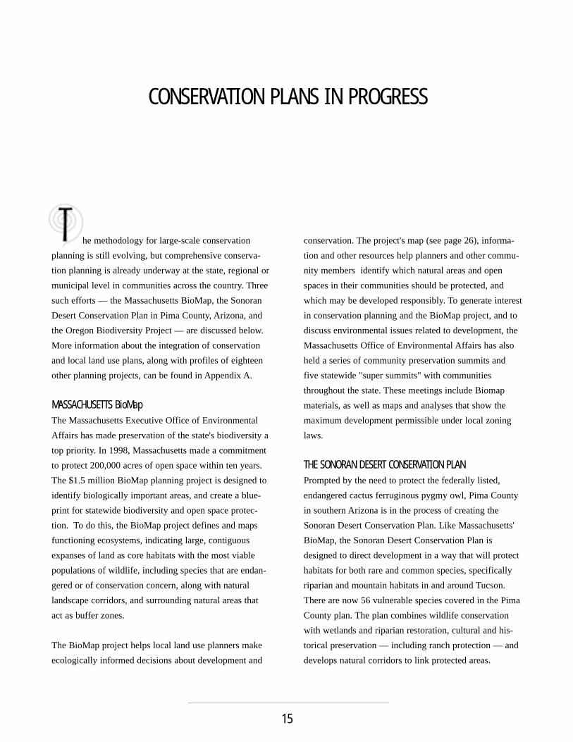
WILLAMETTE RESTORATION INITIATIVERecommendations from several Oregon BiodiversityProject partners and the need to address a variety of envi-ronmental issues in western Oregon's Willamette Basinprompted Governor John Kitzhaber to establish theWillamette Restoration Initiative in 1998. Using informa-tion from the Oregon Biodiversity Project, the Initiativedeveloped a strategy that includes mapping of a potentialconservation network designed to protect biodiversity and ecosystem function throughout theWillamette Basin (see page 29). The Initiative is workingwith local governments, state and federal agencies, andprivate landowners to protect and restore habitat andendangered species, to improve water quality, and man-age flood plains in a way that allows for continued development and growth.
CONSERVATION PLANS IN PROGRESS
16

n recent years, as more has become knownabout biodiversity and conservation biology, scientistshave begun to steer the conservation community towardworking on a larger scale. At the same time, the numberof conservation planning projects around the country hasgrown. Workshop participants were asked to identify therewards and barriers to using such large-scale conservation plans.
Guided by their years of experience with the EndangeredSpecies Act, and their work on conservation assessmentsas part of the Oregon Biodiversity Project, Defenders ofWildlife has developed a proactive, incentive-driven,state-based approach to habitat conservation. One of theworkshop goals was to determine how well such anapproach could be connected to local land use planning.Participants also provided suggestions on how best tocreate and implement comprehensive conservation plansfor their communities, and advice for agencies involvedin this work. The remainder of this report summarizesthat discussion.
THE BENEFITS OF ADOPTING CONSERVATION PLANNINGWorkshop participants helped identify how state, regionaland/or local governments can benefit from conservationstrategies such as those underway in Massachusetts,Oregon and Arizona. A growing number of citizens nowidentify wildlife and natural habitats as essential to ahigh quality of life. Thus, preservation of a community's
natural landscape makes it a more desirable place to liveand work, enhances community pride, and helps raiseproperty values. Yet first and foremost, large-scale con-servation planning helps identify which natural habitatsshould be preserved to protect a particular area's diversityof wild animals and plants.
These landscape-scale conservation plans identify forprotection large blocks of land along with the natural cor-ridors that connect and make these parcels more func-tional. These plans can include other environmentalimprovements, such as stream restoration for flood con-trol, water quality and wetlands protection. Landscape-scale planning works across jurisdictional boundaries, soit can help make acquisition of land for conservationstrategic rather than haphazard. These conservation planscan also help organize, streamline and inform the processthrough which natural resource management agenciesevaluate and set priorities for sites under considerationfor conservation, restoration, and residential or commer-cial development.
The land use and conservation planning process can helpcommunities control growth, prevent urban sprawl, andpreserve open space. Public involvement in this processcan also help enhance a sense of community by provid-ing an opportunity for citizens to express their hopes,values, and visions for their community's future.
WORKSHOP DISCUSSION
17

Community engagement in the details of such a plan cancreate the shared vision necessary for its success.Participation in the planning process also provides community members with some sense of security regard-ing decisions about which areas can or cannot be devel-oped and under what conditions — something particular-ly important to property owners and developers. Oregon'sWillamette Restoration Initiative is a good example ofhow a diverse community came together to develop ashared vision for restoring a large and varied landscape.
A comprehensive conservation plan cannot succeed with-out sufficient funding, and good planning efforts can helpa community attract funding. In addition to the InteriorDepartment's State Wildlife Grants Program, othersources of funding for such conservation projects includefederal and state agencies, charitable foundations, privatedonors, and nonprofit groups. Many states, counties andlocal communities have directed large sums of moneytoward open space acquisition, protection, and manage-ment through ballot initiatives. Many communities alsouse new taxes or bonds to support open space protection.About $23 billion have been secured for such programsthrough state and local ballot initiatives over the past fiveyears. A well-orchestrated plan can help direct funds towhere they will be most effective.
Comprehensive conservation plans can create measurablegoals for biodiversity and habitat protection, and byworking at a landscape scale they can provide the contextfor a broad range of information about the area of con-cern. Both are helpful to government agencies, publicofficials, wildlife and land managers, scientists and con-servationists, especially as they seek to improve the effi-ciency and effectiveness of comprehensive and smallersite-specific conservation projects, as they evaluate pro-posed development, and comply with existing environ-mental regulations. A comprehensive conservation plan
WORKSHOP DISCUSSION
18
BBOOXX 11..
BBEENNEEFFIITTSS OOFF UUSSIINNGG SSTTAATTEE//RREEGGIIOONNAALL CCOONNSSEERRVVAATTIIOONN
PPLLAANNNNIINNGG AATT TTHHEE LLOOCCAALL LLEEVVEELL
• Avoids haphazard conservation by providing a framework forlocal activities, preservation, acquisition and restoration.
• Avoids haphazard development that fragments habitat.
• Promotes species viability and maintains ecosystem function.
• Avoids conflicts over endangered species by providing predictability for all community members and other interestedparties and preventing expensive future mitigation and restoration.
• Strategically targets use of conservation funding (e.g. Land andWater Conservation Fund).
• Attracts more conservation funding for site-specific activities.
• Complements existing environmental and natural hazard prevention programs.
• Justifies local open space and other planning decisions.
• Encourages flexibility in the land use planning process.
• Facilitates ecological, social and political connections across jurisdictional boundaries.
• Creates the opportunity for diverse interest groups to worktogether on creative problem solving.
• Creates a forum for public education on the environment.
• Enhances quality of life and provides economic benefits to communities (e.g. aesthetics, recreation, community pride,tourism, ecosystem services).
• Leaves a positive legacy for future generations.

can also reduce the likelihood of conflict over how toprotect endangered species and the need for costly remediation programs.
Clark County Nevada, home to the city of Las Vegas,completed a multispecies Habitat Conservation Plan in2000. The plan addresses the habitat needs of hundredsof species, including many not yet listed under theEndangered Species Act. The community now feels con-fident its rare species will be adequately conserved, andthat development can proceed without conflict withfuture endangered species requirements.
BARRIERS TO USING CONSERVATION PLANNING AT THELOCAL LEVELDespite the potential rewards, numerous obstacles mayprevent comprehensive planning projects from beingadopted or from achieving their full potential. Theseobstacles include a lack of funding or staff specificallytrained in and assigned to conservation planning projects.Conservation planning can also be hindered by inade-quate ecological data, lack of access to such informationor by lack of access to or training in advanced technolo-gies, such as Geographic Information Systems (GIS).
A lack of political will may be the most imposing — andoften most frustrating — barrier to comprehensive con-servation planning. Because politics and timing are soinfluential in determining which community projectsmove forward, on-going political support is essential tothe success of a long-term conservation strategy. Withoutsuch support, it is difficult to secure funding. Politicalsupport is also needed to overcome the obstacles to con-servation planning that may be posed by outdated stateplanning statutes, inadequate regulations and incentives,and bureaucratic turf battles between agencies. Otherpolitical and social obstacles to conservation planninginclude state fish and wildlife or natural resource agen-cies that may be so focused on hunting and fishing thatthey may not be effective participants in such efforts, and
rural communities that may be less interested in theseprograms than their urban counterparts.
Experience shows that these obstacles can be overcome,but to do so often requires the right kind of political lead-ership. If educated about the issues and involved in theprocess, elected officials can become key factors in aconservation plan's success. Support for conservationplanning is more likely to be forthcoming if elected offi-cials at all levels of government understand how theseplans benefit their constituents and see that such plans
LAND USE PLANNING AND BIODIVERSITY
19
BBOOXX 22..
BBAARRRRIIEERRSS TTOO UUSSIINNGG RREEGGIIOONNAALL//SSTTAATTEE CCOONNSSEERRVVAATTIIOONN
PPLLAANNNNIINNGG AATT LLOOCCAALL LLEEVVEELL
• Lack of political will (state and local).
• State planning statutes that inhibit plan implementation.
• Lack of funding for community involvement, data collection anddissemination, effective planning, implementation, and dedicated staff.
• Lack of relevant incentives and regulations.
• Lack of public participation or local involvement.
• Lack of education on values of natural resources.
• Conflicts with resource use.
• Data issues including access, technical capacity, and lack of infor-mation at appropriate scales.
• Locally significant wildlife habitat left out of large-scale conservation maps.
• Objections from developers and industry.
• Private property rights issues.
• Fear of change and the unknown.

are not created to impose new environmental restrictions.For example, to explain the significance of the BioMapproject to the public, Massachusetts Office ofEnvironmental Affairs staff chose to focus on the connec-tions between community water budgets, developmentand the future of the state's biodiversity.
Other major community concerns about conservationplans include property rights issues, and fear of potentialloss of revenue for local government. Although there isgrowing evidence of the economic benefits and increasedland values associated with conservation (Lerner andPoole 1999), these factors are still not widely or wellunderstood. To gain acceptance, conservation plans mustshow that biodiversity preservation is the best way toprotect the ecological processes essential to human andwildlife communities.
RECOMMENDATIONS FOR CREATING STATE AND REGIONALCONSERVATION PLANSThe relatively few statewide conservation plans that existvary in scope, scale, methodology and detail. This varietyand the experiences shared by workshop participants pro-vided suggestions that can be used to help make futureplans successful. Some of these recommendations aresummarized here.
Good scientific information is crucial to conservationplanning. It is used to identify which areas need whatkind of ecological protection, and to demonstrate to thepublic, political, scientific or legal community how andwhy a plan is valid. Among other things, high qualitydata can show the connections between biodiversity,habitat protection, human health, and the economy.Although scientific information is constantly evolving, itis important to proceed using the best existing data, andto revise plans with improved data when it is available.
Maps are an excellent, visually engaging way to presentscientific and other geographically related data. Good
conservation planning maps will show all land in the areaunder consideration, regardless of ownership. The mapsshould also show:
• The current conservation status of the entire plan-ning area;
• Which land is protected, and its designation;• Which land is targeted for conservation and
restoration;• The location of the natural landscape corridors,
actual or planned, that connect conservation areas.
In Maryland, for example, the state's "green infrastruc-ture" assessment includes a series of maps that form thebasis of the state's new GreenPrint program. Because somuch of Maryland has been developed for agriculture oraffected by urbanization, these maps are useful in assess-ing where restoration is needed, and in locating areas ofcore habitat (hubs) and natural corridors that connectthem (links). Although mapping technology now offersmany options for presenting detailed data, maps need notreveal sensitive data, such as rare species point locationsor private property boundaries.
Comprehensive conservation plans should aim to protectwhole ecosystems, preserve ecological processes and allnative species — both terrestrial and aquatic — for thelong term. While land and water are inextricably linked,they are often approached separately in regulation andconservation. Yet many species depend on both wetlandand upland habitats, so terrestrial and aquatic elements ofthe landscape should be considered concurrently.
Whatever their scope, conservation plans and the mapsproduced for them should use a variety of data. Amongthe sources of such information is the U.S. GeologicalSurvey's Gap Analysis Program, which uses geographicinformation about plants and animals to determine cur-rent gaps in species protection. Each state is workingtoward a gap analysis and most states have producedmaps depicting historical and current vegetation, and the
WORKSHOP DISCUSSION
20

actual and predicted distribution of animals within theirboundaries. Other sources include state natural heritageprograms, which provide data on rare habitats andspecies; The Nature Conservancy, which has compiledecoregional data; and state planning offices, which haveland ownership records. Much of this information existsin electronic format, and Geographic InformationSystems should be used to store and analyze all suchdata.
Specific, measurable goals for the long-term preservationof wild animals, plants and their habitats are essential toa conservation plan's success. Without such goals, a planmay be little more than a large database. To be effective,conservation plans should be developed at the state,regional and local level with explicit and similar method-ology, so they can be used easily by all parties involved.Their implementation strategies should be for the longterm, should clarify what is expected of officials andagencies at all levels of government, and should includepublic education.
To be accepted, the conservation planning processshould, from the start, involve the entire community —including local officials, the public and critics of theprocess. This requires public meetings held at regularintervals and regular communications about the plan'sprogress written so they can be easily understood by all.Representatives of all interest groups and individual citi-zens should be involved in planning sessions and com-mittee work. Undertaking a comprehensive planningeffort with this degree of public participation requirespatience and persistence.
Every region of the United States has a characteristicassemblage of native plants and animals that should beprotected for future generations. Even land heavilyimpacted by human use, such as that in urban areas, maybe important to a biodiversity program. These areas con-tain vital habitat remnants, provide buffers and links to
larger intact conservation areas, and are part of the over-all landscape and ecological processes that determineecosystem health. For these reasons, conservation planscannot be limited to the most pristine areas. In addition,working lands and protected open spaces within urban
LAND USE PLANNING AND BIODIVERSITY
21
BBOOXX 33AA
SSCCIIEENNCCEE && TTEECCHHNNIICCAALL RREECCOOMMMMEENNDDAATTIIOONNSS FFOORR
SSTTAATTEE//RREEGGIIOONNAALL CCOONNSSEERRVVAATTIIOONN PPLLAANNNNIINNGG
• Produce a map of priority conservation areas with linkages. Alllands, whatever their ownership, should be considered in mapping and overall planning processes.
• Use GIS technology for spatial analysis.
• Use a variety of data (e.g. rare species, vegetation, land ownership, etc.).
• Adopt a habitat/ecosystem protection approach. Consider functioning ecological processes and long-term conservation ofnative species.
• Analyze terrestrial and aquatic elements together.
• Use ecological boundaries to help define planning units.
• Create plans at multiple scales (state, region, local) with similarmethodology.
• Produce an explicit methodology with a manual to assist planners.
• Identify and include areas requiring restoration.
• Address threats to wildlife and ecosystems.
• Provide technical assistance and guidance for all interested parties throughout planning and implementation.
• Include an adaptive management component to monitorprogress and periodically update the data and maps.
• Establish a clearinghouse for biodiversity and natural resourceinformation.

areas provide opportunities for many people to experience nature close to home.
To protect biodiversity and natural habitats, more land inthe United States must be managed for conservation. Theexisting statewide conservation efforts have determinedthat roughly 20 to 40 percent of each state's land arearequires some level of ecological protection. Ideally, protected land should be distributed across a variety ofhabitats.
Acquiring land for public ownership and designating itfor ecological preservation is the most effective way toensure full conservation protection, but it is not alwayspossible. Nor, as noted above, is it always possible orappropriate to manage land solely to benefit wildlife. Inmany places, privately owned land can make a signifi-cant contribution to biodiversity protection, and for somespecies and habitats this may be the only option.
RECOMMENDATIONS FOR INTEGRATING REGIONALCONSERVATION PLANS INTO LOCAL PLANNINGLarge-scale comprehensive conservation plans are meantto complement, not take the place of, local land useplans. Conservation plans can be used to direct develop-ment away from ecologically sensitive areas and to mini-mize the effects of development on biodiversity and natu-ral habitats. They can also help local communities shapetheir policies regarding growth management, transporta-tion, and other development issues.
To be effective, local, regional and statewide conserva-tion plans should all use compatible methodology. Alocal plan should bring the community together to setgoals and guidelines, and to create a set of informationalmaps. For example, the Chicago Wilderness project,which encompasses an area of 200,000 acres in threestates and nine counties, a coalition of more than 140public and private organizations adopted a regional biodi-versity conservation plan to guide conservation activities
WORKSHOP DISCUSSION
22
BBOOXX 33BB
IINNSSTTIITTUUTTIIOONNAALL RREECCOOMMMMEENNDDAATTIIOONNSS FFOORR SSTTAATTEE//RREEGGIIOONNAALL
CCOONNSSEERRVVAATTIIOONN PPLLAANNNNIINNGG
• Include multiple stakeholders in the process from the beginning.Develop specific, clear and measurable goals for the long-termviability of native species and natural communities.
• Clarify the roles of local government and all agencies involved.
• Dedicate staff to work with local communities on the assessment, strategy and implementation of the plan.
• Create plans that include biodiversity protection along with otherenvironmental elements, such as water quality improvement, storm water management, recreation, etc.
• Create long-term implementation and site specific conservationstrategies.
• Provide funding for local implementation.
• Develop local pilot projects derived from state or regional planning.
• Develop a variety of incentives and regulations specifically forareas identified in conservation plans.
• Include an education, marketing and communication strategy.
• Familiarize the public with the concept of green infrastructure.
• Link conservation plans to quality of life.
• Document the economic benefits of biodiversity.
• Use such plans to reform state planning statutes. Or use planning reform to initiate or support existing conservationplans.
• Encourage state officials, federal agencies, and political leadersto support local land use planners in carrying out these plans.
• Establish a mechanism for state approval of state, regional orlocal biodiversity plans.

in the planning area's many communities. The planshould identify available open space, gather existingspecies data, and include specific regulations and incentives for preserving biodiversity. It should also pro-vide for the mitigation of past or future habitat losses.
Local officials should take a broad and creative view ofhow zoning ordinances and other land use laws and regu-lations may be used to conserve biodiversity. Zoninglaws and regulations can undermine biodiversity byincreasing habitat fragmentation, or they can help con-serve natural habitats, although not necessarily by estab-lishing preserves. A variety of measures, including con-servation easements, transfer of development rights, spe-cial augmentation of existing zoning, and tax incentivescan, if employed in ecologically sound ways, help createor maintain existing open spaces in working landscapes,such as ranches, farms and private forests. Working land-scapes can promote conservation while maintaining theeconomic value of land and forestalling the kind of intensedevelopment that destroys or fragments natural habitats.
If used strategically, rezoning can be extremely useful inconservation, especially where purchasing land forpreservation is either not possible or desirable. There is,however, an ongoing debate over the merits of "up-zon-ing" and "down-zoning." Up-zoning increases density (byallowing more lots per acre) and is generally favored by"smart growth" advocates as a way to contain sprawl.Down-zoning decreases density (by allowing moreacreage per lot), and has been used by many communi-ties to protect open space from sprawl. Because it isthought to discourage ranches and farms from beingdivided and subdivided, downzoning is usually employedwhen communities seek to preserve agricultural landfrom development.
In many developed communities, zoning may be the bestand only option for protecting the area's remainingwildlife habitat. Either scenario, however, may have an
adverse impact on wildlife and biodiversity. Dense devel-opment can eliminate wildlife habitat completely. If managed properly, farms and ranches can provide somewildlife habitat; if not, they can contribute to its degrada-tion. Historically, wildlife has rarely been considered inrezoning, but regional or statewide conservation planningcan help change this situation. A notable example is theMetropolitan Conservation Alliance, a WildlifeConservation Society program that works in the NewYork City metropolitan area.
THE ROLE OF CONSERVATION ORGANIZATIONSWorkshop participants were asked to suggest howDefenders of Wildlife and other conservation and
LAND USE PLANNING AND BIODIVERSITY
23
BBOOXX 44..
RREEGGIIOONNAALL//SSTTAATTEE PPLLAANNSS IINNFFOORRMM LLOOCCAALL LLAANNDD UUSSEE PPLLAANNNNIINNGG
AATT TTHHEE FFOOLLLLOOWWIINNGG PPOOIINNTTSS::
• Community vision and goal setting.
• Local open space planning.
• Regulations or incentives to conserve biodiversity.
• Review of development proposals and projects.
• Siting of infrastructure facilities in the community (e.g. roads,schools, hospitals, sewage treatment plants, etc.).
• Comprehensive or master planning process.
• Applications of local planning measures (e.g. zoning, conservation easement programs, transfer of development rightprograms).
• Creation of intermunicipal planning councils and agreements.
• Habitat mitigation for development, transportation projects, etc.
• Discussions with public agencies and elected officials should focuson environmental benefits of biodiversity rather than environ-mental constraints.

environmental organizations can help integrate habitatand biodiversity conservation into local land use plan-ning. The list of tasks was long, and included educationcampaigns that would communicate the importance ofbiodiversity and habitat preservation to local and stateofficials, and the public. Another suggestion was to havenonprofit organizations help build on existing knowledgeby sharing information (scientific, technical and proce-dural) from other communities with local planners.Participants felt this would help states define the coreelements of a biodiversity plan, and help planners and the public understand the costs and benefits of implementation.
Conservation groups can help improve and expand publicinvolvement in the comprehensive wildlife conservationplans being created under the State Wildlife GrantsProgram. State fish and wildlife agencies should beencouraged to make their comprehensive wildlife conser-vation planning a collaborative process that involves avariety of interest groups, including conservation organi-zations. Defenders and others should also continue work-ing with the U.S. Fish and Wildlife Service to developpolicy guidelines for the State Wildlife Grants Program.
WORKSHOP DISCUSSION
24
BBOOXX 55..
RREECCOOMMMMEENNDDEEDD NNEEXXTT SSTTEEPPSS FFOORR NNOONNPPRROOFFIITT CCOONNSSEERRVVAATTIIOONN
OORRGGAANNIIZZAATTIIOONNSS
• Promote awareness of state and regional conservation plansaround the country.
• Define the core elements of state biodiversity plans.
• Encourage states to create plans involving multiple public agencies and private partners.
• Assist in translating regional conservation to local planning decisions.
• Work with U.S. Fish and Wildlife Service to develop guidelinesfor the State Wildlife Grants Program.
• Work with and support state fish and wildlife agencies, andencourage them to develop high quality statewide wildlife con-servation plans.
• Showcase specific habitat conservation projects.
• Inform states about conservation planning through examples,process recommendations, and technical assistance.
• Provide information about the connection between biodiversityand other community values.
• Communicate costs and benefits of implementing plans.
• Build constituent support for plan development and implementation.

nformation that would enable every state in thenation to undertake a biodiversity assessment — the firststep toward creating a comprehensive conservation plan— is now available. It is important to remember thatbiodiversity assessments and conservation plans aremeant to complement, not replace, local land use plans.
Biodiversity conservation plans should encompass areaslarge enough to ensure that the entire diversity of habitattypes and species present are included. The areas identi-fied for conservation should be connected whenever pos-sible, and sufficiently large and/or numerous to ensurethe long-term survival of all relevant species. The assess-ment should consider the entire landscape, regardless of ownership, particularly as there are a growing number ofmeasures to facilitate biodiversity protection on privatelands.
To be effective, conservation plans must be developedwithin the context of a state or local community's exist-ing political process, and adapted to reflect local condi-tions. No matter who leads such an effort, a single col-laborative conservation plan should be created, as multi-ple, potentially competing plans decrease the chances ofany being implemented. Creativity and flexibility on thepart of all involved is essential to any plan's success.Workshop participants agreed overwhelmingly that politi-cal will, rather than scientific data, is most likely todetermine a conservation plan's success.
Extensive public involvement and a shared vision of aconservation plan's goals are essential to its success,regardless of the expertise and authority of those leadingthe effort. If the public does not understand, or is suspi-cious of the process, they will reject it. Although not pre-scriptions for local land use, conservation plans willinfluence land use decisions and should be undertakencarefully.
For a statewide comprehensive conservation plan to beimplemented successfully, local governments are likelyto need financial and technical assistance. Personnel atstate natural resource agencies are also likely to needspecial training. The regulatory authority, policy guide-lines, tax incentives and land use tools used in conjunc-tion with conservation plans will probably come from thestate government. Rewards and incentives, which mayinclude financial, technical and legal assistance, are oftenmore persuasive than mandates or penalties in convinc-ing local officials and landowners of a plan's benefits.Pilot projects are extremely useful in demonstrating thebenefits and feasibility of incorporating conservation intolocal land use planning.
Conservation planning is new to many land use plannersand conservationists, and tests the practical applicationsof conservation biology. The United States is such anecologically diverse country, that no single conservationplan can be used as a national model. Most of the plans
CONCLUSIONS
25

presented at this workshop were initiated within the lastten years, and are works-in-progress. All have theirstrengths and weaknesses, and all are achieving somesuccess at the state, regional or local level.
Conservation planning should become the primary meansused to protect biodiversity, and to be successful mustachieve more than what has become the standard,
piecemeal approach to conservation. Conservation plans should connect the importance of biodiversity, habitatand natural resource conservation to a community's qual-ity of life — in theory and in practice. If properly imple-mented, conservation plans will have an impact thatextends beyond the borders of the acres protected orrestored, and help maintain and improve the quality oflife for generations to come.
LAND USE PLANNING AND BIODIVERSITY
26

Massachusetts BioMap
CORE HABITAT
SUPPORTING NATURAL LANDSCAPE
MAJOR LAKES AND STREAMS

APPROXIMATE SCALE IN MILES
012 2 4 10
Pima County Boundary
Major Roads
Incorporated Areas
Native American Jurisdictions
Existing Reserves
Existing Development withinConservation Lands System
Agriculture within Recovery Management Areas
Multiple Use or Recovery Management Areas
Biological Core
Scientific Research Management Areas
Important Riparian Areas
LEGENDARIVACA RD
MOORERD
TWIN
LAKE
S DR
TANGERINE RD
AVRA VALLEY RD
GRIER RD
SAND
ERS
RDSA
NDER
S RD
TRICO
RD
PUMP
STAT
ION
RD
EL TIRO ACCESSRD
AVRA VALLEY RD
ANWA
Y RD
SAND
ARIO
RD
SAND
ARIO
RD
WADE
RD
GERH
ART R
D
BLUE
BONN
ET RD
SCEN
IC D
R HARDYRD
MAGEE RD
INA RD
TANQUE VERDE RD
SNYDER RD
SOLD
IERTR
AIL R
D
CATALIN
A
H
WY
SKYLINE DR
1ST A
VE
RUTHRAUFF RD
SILVERBELL RD
CAM
INO
DEOE
STE
SUNSET RD
PICTURE ROCKS RDGARCIA
RANCH RD
MANVILLE RD
BOPP RD
GREA
SEW
OOD
RD
22ND ST
SPEEDWAY BLVD
12TH
AVE
6TH
AVE
PARK
AVE
VALENCIA RD
OLD VAIL RD
WIL
MOT
R
D
SWAN
RD
LOS REALES RD
ALVE
RNON
WAY
HUGHES ACCESS RD
O L D V A I L C O N N E C T I O N
VALENCIA RDCARD
INAL
RD
WADE
RD
INTE
RSTA
TE 1
9
VALENCIA RD
HERMANS RD
SAND
ARIO
RD
MINERAL HILL RD
PIMA MINE RD
HARR
ISON
RD
DAWN RD
HOUG
HTON
RD
I N T E R S TAT E 1 0
WEN
TWOR
TH R
D
CALL
ERI
NCON
ADO
DAVI
DSON
RD
VAIL
RD
ANDRADA RD
WETSTONESRD
CAMI
NO LO
MA
ALTA
HELMET PEAK RD
DUVAL M INE RD
LA C
ANAD
A
DR
INTE
RSTA
TE
19
ELEPHANT HEAD RD
SASA
BE HW
Y (SR
286)
A JO H IGHWAY
( SR 86 )
STON
E A
VE
ORANGE GROVE RD
WHITE HOUSE CANYON RD
ROM
ERO
RD
ARIVACA-SASABE RD
RUBY RD
DIAMOND BELL RANCH R D
SILVERBELL RD
LAGO
DEL O
ROPA
RKWA
Y
CAMP
BELL
AVE
RIVER RD
OLD
NOGA
LES
HWY
C ATALIN
A HWY
BEAR
CANY
ONRD
AJO WAY
FREE
MAN
RD
ESCALANTE RD
SPEEDWAY BLVD
GOLF LINKS RD
HARR
ISON
RD
MELP
OMEN
E WAY
IRVINGTON RD
MILE WIDE RD
RESE
RVAT
ION
RD
IRVINGTON RD
CAMINO DEL TORO
ROAD
VAIL-
HELV
TIA
SONOITA-MOUNTAI N
VIEW
HWY(SR
83)SONOITA-MTN VIEW HWY (SR 83)
SWEETWATER DR
GATES PASS RD
ANKLAM RD
HOUG
HTON
RD
BROADWAY BLVD
22ND ST
1ST A
VE
CAMP
BELL
AVE
COUN
TRY
CLU
B RD
ALVE
RNON
WAY
KOLB
RD
WIL
MOT
RD
PANT
ANO
RD
CAMI
NO
SECOCR
AYCR
OFT
RD
SWAN
RD
FORT LOWELL RD
PRINCE RD
GRANT RD
COLOSSAL CAVE RD
OLD SPANISH TRAIL
SABIN
OC AN
YON
RD
KOLBRD
SUNRISE DR
ORAC
LERD
LA
CANA
DA
DR
RANC
HO
VISTO SO BLV D
SILVERBELL RD
KINNEY RD
JOSE
PHRD
MISS
IONRD
PALO
VER
DE
BLVD
COUN
TRY
CLUB
RD
CAM
PBEL
L AV
E
D REXEL RD
TWIN BUTTES RD
EL TORO RD
CO N T I NENTAL RDCA
MINO
DEL S
OL
MAD
ERA
CANY
ONRD
MARSH STATION RD
REDI
NGTO
NRDWETMORE RD
NOGA
LES H
WY
MI S
S ION
R D
S I LV E R B E L L R D
TWIN PEAKS RD
SIER
RITA
MOU
NTAI
N R
D
ABINGTONRD
GOLDERRANCH RD
ABREG
ODR
TRICO - MARANA RD
SAN JOAQUIN RD
CAMI
NO
VER
DE
ORANGEGROVE
RD
SASA
BE HW
Y
OLD
TANGERINE RD
NARANJA DR
CAMI
NO D
E O
ESTE
SHAN
NON
RD
LAMBERT LN
CORTARO FARMS RD
MON
A L
ISA
RD
SHAN
NON
RD
EL CAMINO DELCERRO
LOS RE A
L ES RD
SAHUARITA RD
ESPERANAZA BLVD
SAN XAVIERLOOP RD
HARR
ISON
ROAD
CAMINOAURELIA
BREKKERD
OLD SONOITA HWY
BENSONHWY86
286
19
10
83
10
77
SAGUARO
NATIONAL PARK
( W E S T )
TUCSON MOUNTAIN PARK
CORONADO
NATIONAL
FOREST
CORONADONATIONAL
FOREST
C O R O N A D O
CATALINA
STATE
PARKARK
TORTOLITA MOUNTAIN PARK
L A S C I E N E G A S
P L A N N I N GP L A N N I N G
D I S T R I C T
CO
RO
NA
DO
NA
TIO
NA
L F
OR
ES
T
TANQUE VERDEANQUE VERDEGUEST RANCH
TOWNOFSAHUARITA
T U C S O N
TOWNOF
OROVALLEYTOWN
OF
MARANA
SOUTHTUCSON
TOHONO O’ODHAM
NATION
SAN XAVIER
DISTRICT
T O H O N O
O ’ O D H A M
N A T I O N
PASCUAYAQUI
PUEBLO
ARTHUR PACK REGIONAL PARK
B. A
. N. W
. R.
TOWNOFSAHUARITA
T U C S O N
TOWNOF
OROVALLEYTOWN
OF
MARANA
SOUTHTUCSON
SAGUARO
NATIONAL PARK
( W E S T )
BUREAU
OF
RECLAMATION
BUREAU
OF
RECLAMATION
TUCSON MOUNTAIN PARK
BUENOSAIRES
NATIONALWILDLIFEREFUGE
(B.A.N.W.R.)
BUENOSAIRES
NATIONALWILDLIFEREFUGE
CORONADO
NATIONAL
FOREST
CORONADONATIONAL
FOREST
C O R O N A D O
N A T I O N A L
F O R E S T
CATALINA
STATE
PARK
TORTOLITA MOUNTAIN
PARK
S A G U A R O
N A T I O N A L P A R K
( E A S T )
LAS CIENEGAS NATIONAL
CONSERVATIONAREA
L A S C I E N E G A S
P L A N N I N G
D I S T R I C T
E M P I R I T AR A N C H
COLOSSAL
CAVE
MOUNTAIN PARK
COLOSSAL
CAVE
MOUNTAIN PARK
CO
RO
NA
DO
NA
TIO
NA
L F
OR
ES
T
S A N TA R I TA
E X P E R I M E N TA L
R A N G E A N D
W I L D L I F E
A R E A
CA
NO
A
RA
NC
H
CORONADO
NATIONAL
F O R E S T
CORONADO
NATIONAL
F O R E S T
C I E N E GA
C R E E K
N AT U R A L P R E S E R V E
C I E N E GA
C R E E K
N AT U R A L P R E S E R V E
BABOQUIVARI
PEAK
WILDERNESS
AREA
COYOTEMOUNTAIN
WILDERNESSAREA
IRONWOOD FORESTNATIONAL MONUMENT
BINGHAM-CIENEGANATURAL
PRESERVE
A7RANCH
BUEHMANCANYON
TANQUE VERDEGUEST RANCH
ROY DRACHMANAGUA CALIENTE
REGIONAL PARK
SOUTHEASTREGIONAL
PARK
B . A . N. W
. R.
LAS CIENEGAS NATIONAL
CONSERVATIONAREA
Arizona Index Map
PINAL
APACHEMOHAVE
NAVAJO
COCONINO
YAVAPAI
GILALA PAZ
MARICOPA
GREENLEE
GRAHAMYUMA
COCHISE
SANTACRUZ
PIMA COUNTY
PRIORITY BIOLOGICAL RESOURCESof the
SONORAN DESERT CONSERVATION PLAN

B l u e M o u n t a in s
C o l u m b i a B a s i n
LavaP l a i n s
B a s i n & R a n g e
Owyhe e U p l a n d s
Wes
t
East
Cas c
a de s
Wi l l
a me t
t e V
a ll e
y
C o as t
Ra n
g e
K l a m a t h
M o u n t a i n s
P O RT L A N D
S A L E M
E U G E N E
R O S E B U R G
M E D F O R D
P E N D L E T O
L A G R A N D E
B U R N S
R E D M O N D
B E N D
TILLAMOOK BAY WATERSHED
NESTUCCA RIVERWATERSHED
WILLAMETTE RIVERFLOODPLAIN
NORTHCORVALLIS
MUDDYCREEK
ALSEA-SIUSLAW
CAPEBLANCO
UPPER ILLINOIS UPPER APPLEGATE
NORTHMEDFORDPLAINS
UMPQUACONFLUENCE
UMPQUAHEADWATERS
UPPERKLAMATHBASINWETLANDS
DIABLOMOUNTAIN
GEARHARTMOUNTAIN
HONEYCREEK
HARTMOUNTAIN
STEENSMOUNTAIN
CROOKED CREEK-ALVORD BASIN
TROUT CREEK MOUNTAINS
UPPEROWYHEERIVER
MIDDLE OWYHEE RIVER
DRYCREEK
VALEFOOTHILLS
BULLYCREEK
MALHEUR RIVERHEADWATERS
BEARVALLEY
BAKERVALLEY
JOSEPH-IMNAHAPLATEAU
UMATILLA-WALLA WALLAHEADWATERS
LOWERUMATILLA
BOARDMAN-WILLOW CREEK
NORTHWASCO
METOLIUSRIVER
BADLANDS
PINERIDGE
S. FORKJOHN DAY RIVER
PICTUREGORGE
CLARNO
VIDA
WEST EUGENEWETLANDS
COLUMBIA RIVERBOTTOMLANDS
Oregon Conservation Opportunity Areas
CONSERVATION OPPORTUNITY AREAS
CURRENT CONSERVATION NETWORK
OREGON'S ECOREGIONS
TOWNS
The map represents a first cut at a networkof existing and potential areas for conservationin the basin. Information on the map is stillin the process of being refined at local levels.As information on the map is field-checkedand refined, map details will evolve.
The Willamette Restoration Strategy. 2001.Willamette Restoration Initiative
WI L LAMETT E BA S IN
HAB ITAT CONSERVAT ION
PR IOR I T I E S
Map Features
Upland Forests
Prairie
Oak Savanna
Riparian/Bottomland
Wetlands
Conservation PriorityHabitat Types
Cities
Water
OREGON
Portland
Salem
Eugene
Corvallis
I-5
20
22
6 26
99
I-5 26
99
22
20
126
58
126
18
his appendix contains descriptions of conser-vation planning projects represented at the workshop.These projects are divided into three categories:
1. Statewide plans come from states that have com-pleted a comprehensive biodiversity assessment andstrategy for the state's entire land area. Some lessextensive but related projects within these states arealso included.
2. Habitat Conservation Plans describe a series oflarge, regional plans recently completed or inprogress in Arizona, California and Nevada. Theseplans were created to address multiple endangeredspecies issues in urbanizing areas.
3. Various regional plans from around the countrydemonstrate more locally focused examples of con-servation plans produced independently of astatewide plan. These plans are just as sophisticatedas the statewide efforts, but concentrate on an arealimited to a portion of one or more states.
STATEWIDE PLANSStatewide biodiversity assessments and strategiesdescribed in this category have some similar characteris-tics. Each state completed its assessment in less than fouryears with a budget of roughly $1 million dollars. Theland identified ranged from 42 percent to 18 percent. It
should be noted that biodiversity assessments are notprohibitively expensive nor do their associated conserva-tion plans attempt to put the majority of the state's land-scape off limits to any development.
One way of building support for statewide conservationplanning is to showcase a local demonstration projectthat links local land use and conservation planning. Thedescriptions included here for Oregon, Florida,Maryland, Massachusetts and New Jersey describe someprojects that might be labeled demonstration cases.Undertaken separately from the states' recently complet-ed biodiversity assessments and strategies, these projectswere not conceived of as demonstrations for statewidebiodiversity efforts, but did help set the stage for the kindof mapping and planning that the statewide assessmentsentail, and all reflected the goals expressed in the largerstrategies. Five states have completed statewide biodiver-sity plans, and another seven are in the process of devel-oping such plans. With the infusion of funding from thefederal State Wildlife Grant Program, many more stateswill draft and implement biodiversity plans in the nextfew years.
OREGON BIODIVERSITY PROJECT
Defenders of Wildlife initiated the Oregon BiodiversityProject in 1994. Working closely with The NatureConservancy of Oregon and the Oregon Natural HeritageProgram the project produced a statewide biodiversity
APPENDIX A: PROJECT DESCRIPTIONS
33

assessment and outlined a conservation strategy thatincluded 42 "Conservation Opportunity Areas" across thestate. The project's goal was to develop a pragmatic strat-egy for conserving Oregon's native biodiversity. TheConservation Opportunity Areas represent the diversityof habitats and species found throughout Oregon's tendistinct ecological regions. The strategy is designed toprotect native flora and fauna and thus reduce the risk offuture endangered species designations, while givinglandowners more flexibility in resource managementdecisions.
During the assessment, the team evaluated public landsto determine how well those lands are managed to pro-tect biological diversity. Areas were ranked on a ten-point scale. Nature preserves dedicated to biodiversityprotection received higher scores while land used forcommercial, industrial or residential purposes that hadlittle remaining wildlife habitat received lower scores.
Part of the project's strategy was to give conservation pri-ority to areas with the greatest potential for biodiversityprotection. Priority was based on land management, con-tiguity, habitat types represented, species present andlikelihood of conservation success. The prioritized areas,around 18 percent of the state's land, became the strate-gy's Conservation Opportunity Areas. The previouslyexisting conservation network that was composed mostlyof federal and state lands occupied 10 percent of thestate. The Conservation Opportunity Areas overlap withexisting federal lands and, because over 50 percent ofOregon is federal land, federal agency land stewardshippractices have a large influence on the state's biodiversi-ty. Oregon's private lands also contain significant biodi-versity, but are not well represented in the existing con-servation network. Project staff are now focusing muchof their effort on conservation incentives.
Incentive programs are a significant part of the strategyfor protecting biodiversity on private lands. A summary
of conservation incentives used in Oregon was completedas part of the project and prompted a national review ofsuch incentive programs. In 2001, the Oregon legislaturepassed HB3564, a bill that expanded existing conserva-tion incentive programs for private landowners.
WILLAMETTE RESTORATION STRATEGY
The Oregon Biodiversity Project does not have officialstate approval, but its efforts have not gone unnoticed.Over the last four years the governor has supported arelated conservation strategy adopted by the WillametteRestoration Initiative. The Willamette Valley containsroughly 75 percent of Oregon's population, is heavilyimpacted by agriculture and development, and has a longhistory of use by Native Americans and Oregon's earlypioneers. The Willamette Valley is also home to a host ofnative wildlife species associated with the unique oakwoodlands and wet prairie found in few other places inthe state. The initiative attempts to improve the basin'secological health through protection and restoration offish and wildlife habitat while accommodating continuedpopulation and economic growth. Oregon BiodiversityProject staff were instrumental in initiating the programand expanding it into a comprehensive basin-wide con-servation strategy. The strategy contains a map of priorityhabitat conservation habitat that was produced by thePacific Northwest Ecosystem Research Consortiumthrough a five-year, $10 million Alternative FuturesLandscape Modeling Project. By visualizing variousgrowth scenarios, Willamette Restoration Initiative part-ners and participants were able to identify a vision for theWillamette basin. The Alternative Futures Projectrequired new processing of existing data, but not muchadditional data.
At the outset, this collaborative effort brought togetherparticipants from a wide range of interest groups, includ-ing federal, state, and local governments, academia,industry and conservation organizations.
LAND USE PLANNING AND BIODIVERSITY
34

WEST EUGENE WETLANDS, OREGON
In 1992, the City of Eugene adopted a plan to address thefuture of over 1,000 acres of wetlands discovered on thewestern side of the city, an area that had been zoned forindustrial development involving $20 million of infra-structure. Planners, environmentalists, federal agenciesand concerned citizens came together to develop the WestEugene Wetlands Plan. The plan identifies high qualitywetlands for protection, complies with existing federaland state wetlands law, protects rare species, and providespredictable guidelines for development.
The plan uses the existing land use planning process,strategic zoning, and establishes a wetland mitigationbank for the area of concern. It aims to balance environ-mental protection with sound urban development by pre-serving open space, protecting rare species, improvingwater quality and flood storage, and providing advanceidentification of opportunities for and constraints ondevelopment. The plan also highlights the need for biodi-versity protection within areas designated for develop-ment. This is especially true for the aquatic systems thatpass through many of the region's major cities. Eugene'sexperience with wetlands has helped prompt aMetropolitan Regional Parks and Open Space Study for asystem of connected open spaces around the region's hillsand waterways.
After the wetlands were discovered, a full biologicalinventory was completed. The inventory produced a maprecommending 48 percent of the wetlands for protection,20 percent for development and 30 percent for restora-tion. Criteria were developed for determining each statuscategory and all wetlands were evaluated. Developingany wetlands normally requires a permit under section404 of the Clean Water Act. These permits are usuallyarranged on a site-specific basis, so they often lack alarger ecological perspective and require more time toprocess than they would if a whole wetland complex wasevaluated at once. The West Eugene Wetlands Plan is a
significant departure from the norm, streamlining the per-mit and conservation process by adopting the larger plan.To date, 2,500 acres comprising more than 100 parcels ofland have been protected, all acquired from willing sell-ers. The project has received $12 million in federal Landand Water Conservation Fund support.
To implement the plan, the city adopted a series of zon-ing changes in 1995. These changes included a naturalresource zoning district, a waterside protection zone forstreams, and a protection zone around key wetlands. Foreach of these areas the zoning aims to provide wildlifehabitat, protect water quality, and prevent damage fromflooding. Biodiversity protection is an important goal, butis not the only reason for these land use controls. Thewetland mitigation bank was created to coordinate miti-gation projects for developers working within the plan-ning area. Developers can purchase wetland mitigationcredits that sell for $30,000 each; a total of $960,000worth of credits have been purchased. The revenue frommitigation credits goes directly toward restoring signifi-cant wetlands identified in the plan rather than to discon-nected sites elsewhere in the state. The seed used forrestoration projects must be native to the region andcome from within a 25-mile radius of the planning area.This practice ensures that the restored wetlands will con-tain a historic genetic composition. The developersinvolved are assured a predictable and streamlinedprocess and don't have to organize or manage the restora-tion work themselves.
The Oregon Biodiversity Project described above wasinitiated after the West Eugene Wetlands Plan was wellunderway. Since much of the attention generated from theOregon Biodiversity Project focused on the WillametteValley where Eugene is located, the wetland protectionserves as a model for other communities seeking to buildtheir own conservation networks, restoration plans andopen space programs. The West Eugene Wetlands Planalso coincides with the objectives of the Oregon
APPENDIX A: PROJECT DESCRIPTIONS
35

Biodiversity Project. Although conservationists recom-mend an orderly process of regional ecological assess-ment as the basis for local planning, many progressivecommunities, such as Eugene, have already started proj-ects that address biodiversity on a local level.
FLORIDA CLOSING THE GAPS PROJECT
In 1994, Florida's Fish and Wildlife ConservationCommission produced a comprehensive statewide biodi-versity assessment and strategy entitled Closing the Gapsin Florida's Wildlife Habitat Conservation System (Coxet al. 1994). The report identified existing conservationlands and additional areas in need of conservation neces-sary to safeguard the state's wildlife. The initial assess-ment evaluated the needs of 40 wildlife species, 105 rareplants, four priority habitat types, wetlands for wadingbirds, and bat roosts. Overall, 33 percent of the state wasidentified for conservation, about two-thirds of whichwas already protected. The remaining 13 percent of thestate lands targeted for protection comprise 4.82 millionacres called Strategic Habitat Conservation Areas. In1998, a second phase of the project analyzed habitatneeds for an additional 125 species and identified 59,806acres to add to the Strategic Habitat Conservation Areas.The project is now in its third phase with another updateexpected in 2003. With each update the project uses newinformation about species and habitats, and evaluatesprogress made toward achieving its conservation goals.Since the project's inception the state has protected onemillion acres, or 20 percent of the strategic areas, at acost of $1.92 billion.
A key aspect of the plan is its attempt to evaluate the via-bility of the species targeted for conservation. Populationviability has been a contentious issue within the scientificcommunity, often requiring extensive and expensive datagathering and monitoring. Florida's assessment is a verypractical application of these viability concepts andserves as a model for other conservation plans. A seriesof 40 focal species were chosen because of their large
area habitat requirements or their ability to serve as indi-cators of the health of natural communities. For eachfocal species a set of minimum areas was identified tosecure 10 populations of 200 individuals, each distributedover a broad enough area so catastrophic events wouldnot eliminate the populations all at once. Those areas,identified both within and outside existing conservationlands, were then combined with other information on rarespecies and rare plant communities to produce the finalmap of strategic areas.
Florida has no specific statewide policy on biodiversity,but does have at least three state policies that addressbiodiversity protection. The state's Comprehensive Plancalls for "protecting and acquiring unique natural habi-tats" and establishes a mechanism for conserving fish,wildlife, marine life, endangered species and varioushabitat types. Florida's Growth Management Act requireseach county and municipal comprehensive plan toinclude a conservation element to specify the use, protec-tion and conservation of natural resources includingwildlife and marine habitat as well as native plant com-munities. Whether or not communities choose to use themaps and habitat information developed for the StrategicHabitat Conservation Areas in their planning has beensomewhat controversial, but the program does enablelocal governments to pursue wildlife habitat protectionunder the auspices of growth management. In 2001, theFlorida Forever Act was passed to build upon a success-ful Preservation 2000 program that devoted public fundsto the protection of open space and wildlife habitat.Florida Forever is a ten-year program designed to spend$3 billion on acquiring land and water resources. Wildlifeprotection is one aspect of the Florida Forever program.To guide and prioritize spending, the program uses aConservation Needs Assessment, which includes theStrategic Habitat Conservation Areas as one layer.
The results of the Closing the Gaps project have beenused in parts of peninsular and southern Florida for
LAND USE PLANNING AND BIODIVERSITY
36

regional planning, and strategic areas have been incorpo-rated into some county comprehensive plans. However,because of private property concerns, some communitiesin the northern and central portions of the state haveresisted using these maps and associated information forplanning. Yet the state has made extensive use of conser-vation easements to add land to the conservation networkand to secure habitat protection while leaving the land inprivate ownership. This approach has become increasing-ly popular with private landowners who stand to receive80-90 percent of their property's fair market value in aneasement while retaining ownership of the property. Asmore communities learn about this program, support forthe habitat maps has grown.
FLORIDA ECOLOGICAL NETWORK
The concept of creating an integrated habitat conservationsystem for Florida grew out of work initiated in the1980's by Larry Harris, Reed Noss and others, to plancomprehensively for the protection of the state's irre-placeable habitat for native wildlife. The FloridaGreenways Program began in early 1991 as a cooperativeeffort of 1000 Friends of Florida and The ConservationFund. The program goal was to create a vision and frame-work for a statewide greenways system. One of the mostsignificant accomplishments of the Florida GreenwaysProgram was Governor Lawton Chiles' creation of theFlorida Greenways Commission. The Florida GreenwaysCommission was created for a three-year period (1993-1995) ". . . to plan and support a statewide system ofgreenways linking natural areas and open spaces to bene-fit Floridians today and in generations to come" (FloridaGreenways Commission 1994). The 40-memberCommission represented a variety of interest groups fromacross the state. The result of the Commission's work in1993 and 1994 was the preparation of a report entitledCreating a Statewide Greenways System: for People…forWildlife…for Florida. The Commission's concept was thatthe statewide greenways system would be composed oftwo sub-systems or networks: an Ecological Network,consisting of ecological hubs, linkages and sites along
rivers, coastlines and across watersheds; and aRecreational/Cultural Network with trail corridors, con-necting parks, urban areas, working landscapes and cul-tural/historic sites.
In 1995, Florida's Greenways initiative changed from anon-governmental organization-based program and agubernatorially appointed Commission to a government-based program and legislatively appointed Council. TheFlorida Department of Environmental Protection was des-ignated the lead state agency for the program. TheDepartment of Environmental Protection contracted withthe University of Florida to develop the physical designfor the statewide greenways system, and worked with theFlorida Greenways Coordinating Council to prepare animplementation plan (Florida Department ofEnvironmental Protection, Florida Greenways Council1998). The plan was forwarded to the legislature inFebruary 1999 and resulting legislation was signed intolaw in June 1999.
The Florida Ecological Network was designed as the eco-logical component of the statewide greenways system.The network was based on six strategies to conserve thestate's native ecosystems and landscapes that were identi-fied by the Florida Greenways Commission:
• To identify and conserve an integrated, statewidesystem of greenways that encompasses the fullrange of Florida's native ecosystems and landscapes;
•To use Florida's rivers, springs, lakes, and otherinland and coastal aquatic features as strategicbuilding blocks in the statewide greenways system;
• To link a full range of regional landscapes throughFlorida's system of greenways and landscapes thatinclude publicly owned lands harboring nativeecosystems and privately owned, highly managedforestry and agricultural properties;
APPENDIX A: PROJECT DESCRIPTIONS
37

• To plan and manage the statewide system of green-ways using the best information available about therequirements of Florida's native ecosystems andlandscapes;
• To address native ecosystem conservation andhuman use compatibility issues by developinggreenway design and management guidelines; and
• To undertake and/or support the research and moni-toring efforts necessary to effectively plan and man-age native ecosystems and landscapes withinFlorida's system of greenways (Florida Departmentof Environmental Protection, Florida GreenwaysCouncil 1998).
The development of the Ecological Network was under-taken in a two-step process. First, a GIS DecisionSupport Model was used to categorize both native andnon-native landscape features in terms of their signifi-cance and compatibility with ecological conservationobjectives. The GIS model used a diversity of spatialdata including biodiversity data from the Florida Fishand Wildlife Conservation Commission's Closing theGaps report and the Florida Natural Areas Inventory aswell as data depicting features with water resource andother conservation values. First, the areas of largest andhighest quality were selected as hubs for the EcologicalNetwork, then linkages among those hubs were identi-fied. In the final ecological modeling step, these hubsand linkages were combined to create a preliminaryEcological Network. The ecological modeling resultsincorporated approximately 57 percent of the state,including coastal waters. Open freshwater, coastal waters,existing public conservation lands, and private preservescompose 53 percent of the model results. Proposed pub-lic conservation lands compose 10 percent of the modelresults. Other private lands comprise 37 percent of theresults, approximately one-third of which is either wet-lands or within 100-year floodplains.
The second step in the Ecological Network developmentprocess involved public review of the results of the GISmodel, and incorporation of those comments into theplan. The public participation process included threeforums: the Florida Greenways Workshop Series in 1996;the work of the six Regional Greenways Task Forces,including public hearings, in 1997 and 1998; and thework of the Florida Greenways Coordinating Council,including public hearings, in 1997 and 1998. Primaryfunding for the design of the Statewide GreenwaysSystem came from Florida Department ofTransportation's ISTEA (Intermodal SurfaceTransportation Efficiency Act) Program.
The statewide assessment identified a diversity of signifi-cant conservation hub linkages across the state. The fivelargest hubs consist of habitat complexes composed ofnational park, national wildlife refuge, national and stateforest, Air Force, and other public and private lands.These hubs serve as anchors and therefore are the major"destinations" for identified linkages and corridors ofpublic and private lands. These hubs encompass riverfloodplains, coastal and interior wetlands, and uplands.
From the descriptions of its design and components, theutilitarian aspect of the plan is clear, but its EcologicalNetwork is also biologically robust. If fully implemented,the Ecological Network would maintain genetic diversityof native biodiversity and keep natural landscape func-tions intact so that evolutionary processes can proceed.The Ecological Network employs a "fine filter" and"coarse filter" approach which, when combined, shouldsupport the greatest level of native biodiversity. A "finefilter" targets specific endangered or threatened species,such as the Florida scrub jay. In contrast, a "coarse filter"identifies and protects an entire ecosystem or communityand all of the associated species. Fine filters help toensure protection for species with particularly large orspecific habitat requirements that might slip through thecracks of a coarse filter. Using this approach, the network
LAND USE PLANNING AND BIODIVERSITY
38

seeks to protect all 81 ecological communities identifiedin Florida, which are home to 600 vertebrate species (115of which are endemic to Florida) and 3,500 vascularplants (300 of which are endemic to Florida).
This statewide assessment maps out a "green infrastruc-ture" for the State of Florida. Green infrastructure is arelatively new concept now being applied in many com-munities across the country (Benedict and McMahon2002). The Conservation Fund, working with the USDAForest Service, has assembled a group of federal andstate agencies and non-governmental organizations torefine the concept and educate communities about greeninfrastructure principles and strategies: "Infrastructure isan interconnected network of green space that conservesnatural ecosystem values and functions and providesassociated benefits to human populations" (Benedict andMcMahon 2002). The Ecological Network and theFlorida Greenways Program are designed not only toprotect and manage Florida's biodiversity and waterresources, but to connect the people of Florida to theirnatural environment, and develop more support for natural resource conservation.
MARYLAND GREEN INFRASTRUCTURE ASSESSMENT AND GREENPRINT
PROGRAM
Modeling its effort on Florida's Ecological Network, theMaryland Department of Natural Resources completed astatewide Green Infrastructure Assessment in 1998. Theassessment identifies a network of hubs and corridorsthat would link and protect the most critical remainingundeveloped lands before they are lost or fragmented. Ina proactive application of available information devel-oped by different state and federal agencies, the GreenInfrastructure Assessment uses GIS and principles oflandscape ecology to identify landscape hubs, nodes, and corridors (links) for protection and/or restoration. Aswith the Florida Greenways effort, the goal of the assessment to identify ecologically significant lands forbiodiversity can also dovetail with recreational areas
along waterways, on trails and in parks. However, theemphasis of the assessment is biodiversity, and 98 per-cent of significant areas for biodiversity identified byMaryland's natural heritage program are included in theassessment.
The Green Infrastructure Assessment began as a projectof the Maryland Department of Natural Resources water-shed management program, and the results were formal-ized by the governor into a land protection programcalled Maryland GreenPrint. The Green InfrastructureAssessment serves as the ecological basis for theGreenPrint program. Officially adopted in 2001, the pro-gram has received $35 million in state funds. The pro-gram will make use of Maryland's existing land preserva-tion programs: Program Open Space and the RuralLegacy Program. These two programs have been suc-cessful in protecting hundreds of acres of land for bothrecreational and rural preservation purposes. Now, withthe Green Infrastructure Program, ecological conservationwill become a more significant consideration.
The GreenPrint program is also intended to mesh withMaryland's existing Smart Growth program where mapsdeveloped for GreenPrint will be critical in creating aneffective link. Maryland's "smart growth" program waslast updated in 1997 with legislation that called for thecreation of priority funding areas in each municipality.Unique among similar statewide programs because it isnon-regulatory, the priority funding areas receive prefer-ential funding for infrastructure to encourage develop-ment to take place within these boundaries. Developmentis permitted outside these areas, in compliance withexisting land use zoning, but because developers mustpay for their own infrastructure, it is hoped that they willbe discouraged from doing so thus slowing down the rateof expansion.
The GreenPrint program is fairly new, but in upcomingyears more counties will use the maps as their
APPENDIX A: PROJECT DESCRIPTIONS
39

comprehensive plan land use codes come up for review.The Maryland Department of Natural Resources has metwith representatives from each county's planning andzoning and parks and recreation departments, and othersto review the maps and GIS model. Because the networkof hubs and links serves as the ecological compliment toa network of greenways and trails, the MarylandGreenways Commission plays an important role in out-reach for and implementation of the GreenPrint program.South of Washington D.C., St. Mary's, Calvert andCharles counties attempt to coordinate their activitiesthrough the Southern Maryland Tri-County Council. In1999 the council adopted a regional strategy that includesthe goal of creating a green infrastructure using theresults of the Green Infrastructure Program.
Another important feature of the assessment is its identi-fication of areas requiring restoration. One such site isChino Farms, a 6,000-acre private farm located in ahydrologically significant part of the Middle ChesterRiver watershed on the eastern shore of Maryland. Thelandowner retains ownership of the property, but hasdecided to work with the Maryland Department ofNatural Resources to make significant wildlife habitatimprovements guided by the assessment. Forest restora-tion projects have already begun there. Without theassessment, such projects would never have been consid-ered. These restoration projects also demonstrate howstate and federal incentive programs can be used toachieve habitat improvements without infringing on private property rights.
BALTIMORE GREENWAYS
Of Maryland's 24 counties, Baltimore County andMontgomery County have been the most active in build-ing greenway networks. These counties lie within themetropolitan corridor between Washington D.C. andBaltimore, and are home to most of Maryland's residents.Protecting biodiversity in a landscape with so muchdevelopment pressure is a challenge, and significant
habitat has already been lost. The greenways and parkssystem assembled over the last 50 years focuses primari-ly on stream valley parks, and there is some protectionfor the habitats favored by native species. The areas thatBaltimore focuses on for greenways protection were alsoidentified in the state's Green Infrastructure Program.One of the challenges here, as in many other urban areas,is how to expand the network of conservation landsbefore they become developed, and to control the inva-sive species that threaten many parks and other naturalareas.
The city of Baltimore has a history of land conservationplanning that dates back to the 1960s. Noted landscapearchitect Ian McHarg in his classic text, Design withNature, describes a project one of his classes undertookto evaluate the possible uses of the rural agriculturallands surrounding Baltimore (McHarg 1969). McHarg'sinformation was less complete than what we now have towork with, but many of his recommendations for landuse continue to be used by Maryland's Valleys PlanningCouncil. In 1967, using the McHarg study, BaltimoreCounty established an Urban-Rural Demarcation Line toseparate areas of intensive development from rural areaswhere development would be limited or discouraged. Thebulk of the county's recent growth has been focused indesignated growth areas where planning mechanisms anddevelopment regulations work to ensure that communi-ties remain attractive with ample open space interspersedwith the planned development.
Taking in portion of 14 major watersheds which flowinto Chesapeake Bay, the rural and urban portions ofBaltimore County's 640 square miles of land still containremnants of habitat for biodiversity. The county's morethan 2,100 miles of non-tidal streams and rivers form thebackbone of the county's existing greenways system andretain the best examples of native biodiversity. The"Baltimore County Master Plan, 1989-2000" designated avast network of streams and rivers as greenways, and
LAND USE PLANNING AND BIODIVERSITY
40

formalized the county's ongoing efforts to attain and pre-serve linear landforms (especially along stream valleys)for recreational and environmental purposes. This impor-tant step laid the groundwork for the county's acquisitionof land along its designated greenways.
Two other significant steps in the county's greenwayseffort took place between 1999 and 2000. The first wasapproval of the greenways-related recommendationswithin the recently completed "Baltimore County MasterPlan 2010." These recommendations, which are called"actions" in the plan, include the delineation of additionalstream-related greenways, and implementation of a clas-sification system to make a distinction between all green-ways as either "recreational" or "environmental." Thesetwo types of greenways were further defined within themaster plan as follows:
• Environmental greenways will remain predominant-ly natural and serve as open space and wildlife cor-ridors, with little if any public access.
• Recreational greenways are intended for public useand may include improved trails and other recre-ational amenities.
The second accomplishment, also a recommendationwithin the Master Plan, was the formulation and approvalof the county's updated Local Open Space Manual,which added new greenways-related standards to theexisting planning process. This manual requires that anygreenways created within properties being subdivided beaccessible by the public, as well as for emergencies andmaintenance. These "greenways standards" also definethe extent of greenways created, whether by reservationor easement — on any properties being subdivided,regardless of zoning by reservation or easement — tothe 100-year flood plain, wetland or forest buffer,whichever is greater.
With its protection of stream valley parks that set asidesome of the state's most significant habitat for species,Maryland made an unconscious commitment to biodiver-sity protection. If other U.S. cities (especially those in thearid west) had taken such steps as their communitiesdeveloped, many species might have been kept off thefederal endangered species list. Development in streamvalleys creates economic and ecological problems.Efforts to restore such riparian lands with ecologicallyfunctional greenways are an excellent way to help main-tain local biodiversity.
NEW JERSEY LANDSCAPE PROJECT
New Jersey is the most densely populated state in thecountry. Since 1972 the state has lost 20,000 acres ofwildlife habitat each year. The Landscape Project, initiat-ed by the New Jersey Division of Fish and Wildlife'sEndangered and Nongame Species Program in 1994,attempts to address this habitat loss by providing scientif-ic information about the distribution of biodiversityacross the New Jersey landscape. It is a statewide,ecosystem-level approach to the long-term protection ofrare species and critical habitat. The project's goal is "toprotect New Jersey's biological diversity by maintainingand enhancing rare wildlife populations within healthy,functioning ecosystems." The project aims to make scien-tifically sound information easily accessible to planningand protection programs throughout the state. This infor-mation, including GIS maps, is available through theNew Jersey Department of Environmental Protectionweb site (http://www.state.nj.us/dep/gis/). The maps mayserve as the basis for developing habitat protection ordi-nances, critical habitat zoning, or land acquisition andmanagement projects. The project also anticipates thatuse of this information will encourage better planningand reduce conflicts over endangered and threatenedspecies protection.
A relatively straightforward method is used to identifyand map critical habitat. First, satellite images of land
APPENDIX A: PROJECT DESCRIPTIONS
41

cover and land use are examined to identify habitat typesand contiguous habitat patches. Next, rare species loca-tions are intersected with the habitat patches. Finally,habitat patches are given weighted values based on theprotection status of the species present (i.e., federally listed, state endangered, state threatened, state priority).A final composite map is produced, showing weightedhabitat values for every part of the state.
New Jersey's landscape project is one of the few conser-vation plans that assigns conservation values for theentire state, not only for sites that have been identifiedas most critical. Although the maps produced in this proj-ect do not make up a typical statewide conservation net-work, they do attempt priorities for protection. With theinformation in these maps, communities will have thetools to make informed conservation decisions.
NEW JERSEY PINE BARRENS
The New Jersey Pine Barrens comprise a 1.4 million-acrearea. It is the largest contiguous tract of forest along themid-Atlantic seaboard, and is rich in biodiversity. Thetopography is generally flat with sandy soils that supporta series of cedar and sphagnum swamps along with vasttracts of pine forest. Underneath the barrens is a hugefreshwater reservoir, the Kirkwood-Cohansey aquifer,that contains an estimated 17 trillion gallons of water.The health of the aquifer is important to the ecologicalbalance of the coastal estuaries which are critical to manyspecies. The aquifer also supports the region's streamsand agriculture, and provides drinking water for hundredsof thousands of people. Protecting the aquifer's waterquality and quantity is essential to natural resource pro-tection in the Pine Barrens and a driving force behindmaking the area a preserve, which is now of national sig-nificance. Today, development is the greatest threat to thePine Barrens.
In 1978, the National Parks and Recreation Act recog-nized the ecological significance of the New Jersey Pine
Barrens and established the Pinelands National Reserve.Establishment of the reserve came through New Jersey's1979 Pinelands Protection Act, which created the NewJersey Pinelands Commission to manage the area. TheCommission uses a Comprehensive Management Plan,essentially a regulatory land use tool, to restrict develop-ment over large areas in the Pinelands Reserve. The planalso attempts to regulate land uses in ways that are com-patible with the preservation of the underlying aquifer.
The Pinelands National Reserve is 1.4 million acres of"working landscape" where farming, ranching, forestryand other land uses are managed in a way that maintainswildlife habitat and biodiversity. Development and agri-cultural land uses of various kinds are permitted through-out much of the reserve, including the most ecologicallysensitive area where cranberries and blueberries are pro-duced. The peripheral areas of the reserve allow residen-tial development according to various low-density formu-las that allow 1.5 to 5.25 dwelling units per acre. Themilitary (primarily Fort Dix) also manage areas in thereserve.
The Pinelands Comprehensive Management Planincludes an innovative transferable development rightsprogram designed to mitigate the economic loss of alandowner whose property is heavily restricted whileapplying permanent deed restriction for the most ecologi-cally important areas. Landowners in the plan's preserva-tion districts are allocated Pinelands DevelopmentCredits, while developers in the growth districts get "den-sity bonuses" if they purchase and retire credits as part oftheir development applications. When a landowner sellscredits, his or her land is automatically deed-restrictedfrom development, giving that land permanent protec-tion. The plan also creates a state agency, the PDC Bank,which acts as the buyer and seller of last resort to helpensure that the market in Pinelands Development Creditsworks well. During the first 20 years of the program,sales of credits have led to deed restrictions on 27,750
LAND USE PLANNING AND BIODIVERSITY
42

acres of land. The program, which supplements the eco-nomic value of land in the preservation districts, has alsohelped New Jersey successfully defend the plan againstconstitutional takings claims.
Experience with the Pinelands National Reserve suggeststhat a "working landscape" approach to habitat conserva-tion may be successful. Although very little of thePinelands Reserve can be termed pristine, it has a func-tional ecosystem and a management plan that strives tobalance human use and conservation. To help with thisbalance, the Pinelands Preservation Alliance, a non-gov-ernmental organization, was formed specifically toenhance conservation of the region's natural resources byworking with the Commission and through communityoutreach.
The Pinelands National Reserve ComprehensiveManagement Plan is one of the United States' few long-term examples of conservation planning. It successfullyuses regulatory tools to achieve conservation goals. Overthe preserve's 20-year history, residents have learned tolive with and value these regulations, yet progress hasbeen slow because changes to these regulations are con-troversial.
MASSACHUSETTS BioMap
Funded by the Massachusetts Executive Office ofEnvironmental Affairs, the BioMap Project was initiatedby the Massachusetts Natural Heritage and EndangeredSpecies Program in the spring of 1998. Project collabora-tors included the Massachusetts Executive Office ofEnvironmental Affairs, Massachusetts Division ofFisheries and Wildlife, MassGIS, Manomet Center forConservation Sciences, The Nature Conservancy,Harvard Forest, and the Natural Heritage Programs ofNew Hampshire, Vermont, New York, Connecticut, andRhode Island. The goal of the project was "to promotestrategic land protection by producing a map showingareas, that if protected, would provide suitable habitat
over the long term for the maximum number ofMassachusetts' terrestrial and wetland plant and animalspecies and natural communities." The MassachusettsBioMap was created using GIS technology to processstate rare species and exemplary natural communitiesdata. The map identifies 2,130,000 acres (42 percent ofthe state) as important to the long-term conservation ofspecies and natural communities. Of the area identified,1,160,000 acres are considered Core Habitat (23 percentof the state), and 970,000 acres are consideredSupporting Natural Landscape (19 percent of the state).The statewide "BioMap" and other products, including areport, technical appendix, and poster, were completed inthe summer of 2001.
The BioMap is now being used as a tool to facilitateinformed land conservation decisions, including landacquisition priorities, throughout Massachusetts. TheExecutive Office of Environmental Affairs encouragestowns to use the BioMap to guide land use planningdecisions as part of their Community Preservation. TheCommunity Preservation Initiative is designed to addressthe problems associated with urban sprawl that affect thequality of life of the state's residents. It is essentially alocally driven smart growth effort for the state. TheExecutive Office of Environmental Affairs held 24Community Preservation summits across the state wherethey presented information on how existing local zoningwould affect development in each community. These"build out analyses" also showed impacts to waterresources and biodiversity.
An educational component of the BioMap areBiodiversity Days designed to generate interest in biodi-versity among communities throughout the state. Duringthis event, participants are encouraged to get out andexplore the native biodiversity of their areas with supportfrom local experts and Executive Office ofEnvironmental Affairs staff. A workbook calledExploring Biodiversity accompanies materials for the
APPENDIX A: PROJECT DESCRIPTIONS
43

event and provides a general overview of the threats tobiodiversity and information on how to collect field data.Reports of observations can be submitted to local speciesand habitat registries or to the state natural heritage pro-gram if rare species are observed.
The Trustees for Reservations, the Executive Office ofEnvironmental Affairs, and the City of Fall River haverecently established a "core habitat" along Fall River asthe southeastern Massachusetts BioReserve. In August2002, the state legislature passed a bill authorizing thetransfer of land to establish the southeasternMassachusetts BioReserve. This area is more than 13,600acres, and although its significance has been known forsome time, the BioMap demonstrates its significance in astatewide context. The purpose of the bioreserve is toprotect, restore and enhance the biological diversity andecological integrity of a large-scale ecosystem represen-tative of the region; to permanently protect public watersupplies and cultural resources; to offer interpretive andeducational programs; and to provide opportunities forappropriate public use of the land. Although theBioReserve has been established, the threats of sprawlare apparent and immediate action and developmentrestrictions are needed.
Creating the Bioreserve is one strategy to protect areasidentified on the BioMap. Another strategy is the use ofconservation easements, called "conservation restric-tions" in Massachusetts. All "conservation restrictions"must be approved through the Executive Office ofEnvironmental Affairs to ensure they will result in ademonstrated public benefit. The BioMap can serve as aguide to locate areas for "conservation restrictions."
WASHINGTON STATE GROWTH MANAGEMENT AND ECOREGIONAL
CONSERVATION
The State of Washington's Growth Management programbegan in 1990 with the passage of the state's GrowthManagement Act. The flexible program, run by the state's
Office of Community Development, encourages growthto take place in locally defined Urban Growth Areas. Theact also requires each of the state's 39 counties to identifyfish and wildlife conservation areas, designate areas criti-cal to conservation, and establish development regula-tions to help protect these areas. Washington loses anestimated 70,000 acres of fish and wildlife habitat eachyear, mostly to development, so conservation has becomecritical. To justify the protection of critical areas, the pro-gram has produced a synthesis of the best available sci-ence. It has also initiated a Puget Sound DemonstrationProject to examine alternative future scenarios for landand water resource use involving conservation sites. Theprogram has developed model planning code language tobe used in designating and protecting critical areas.
Most recently, Washington's Office of CommunityDevelopment has teamed up with the WashingtonDepartment of Fish and Wildlife, Department of NaturalResources and The Nature Conservancy on an ecoregion-al planning project to protect state biodiversity. The proj-ect is modeled after The Nature Conservancy's ecore-gional approach, but modified to fit state boundaries.Washington contains parts of eight ecoregions in whichsites of significant habitat and biodiversity will be identi-fied. The results will be coordinated with other state con-servation efforts, prioritize land for conservation ease-ments and other protections, help counties plan forwildlife habitat conservation across their jurisdictionalboundaries, and assess potential sites for MarineProtected Areas. The four-year planning process isexpected to cost $3.5 million. The Washington Office ofCommunity Development will help create and translatethe resulting plans to local governments. WashingtonState is one of only a handful of states with plans to linkits comprehensive statewide wildlife planning processwith its policies on growth management.
The ecoregional conservation approach will not meet allof the Washington Department of Fish and Wildlife's
LAND USE PLANNING AND BIODIVERSITY
44

goals for fish and wildlife management, so county planswill also be created. In addition to conserving fish andwildlife diversity, the agency's goals include maintainingthe historic distribution and viability of species and habi-tats, recovering threatened and endangered species, andenhancing fish and wildlife populations for harvest. Thecounty is the appropriate geo-political unit for addressingthese conservation goals because counties are responsiblefor implementing the State Growth Management Act,which requires comprehensive land use planning and pro-vides a regulatory framework for controlling the impactsof growth on fish and wildlife habitats.
Washington Department of Fish and Wildlife currentlyparticipates in county growth-management planningthrough the state's Priority Habitats and Species Program.The existing program provides counties with informationabout the location of important fish and wildlife habitatsand recommendations for their management. Agencyhabitat biologists then consult with county planners orlandowners on a site-by-site basis when development per-mits come up for review. The biologists also work withcounty planners to improve Critical Areas Ordinances andopen space plans. Yet because it works on a site-specificbasis, the Priority Habitats and Species Program approachdoes not address larger landscape issues of habitat con-nectivity, regional or local species viability, multi-countyhabitat issues, or prioritize habitat areas for protection.The State Office of Community Development, whichadministers the Growth Management Act, encouragescounties to address these issues, but does not have theresources to do this alone.
Washington Department of Fish and Wildlife is workingto develop a scientifically sound tool that will enablecounties to do landscape-scale conservation through theGrowth Management Act. The community development
office is now using a decision-making tool called"Alternative Futures" to evaluate the impacts of variousdevelopment scenarios on important fish and wildlifehabitats in the Chico Creek watershed of Kitsap County.Washington Department of Fish and Wildlife will adaptand improve these methods in a pilot project covering allof Kitsap County that will be completed by December2003. The project has two elements:
1) A draft conservation network for the KitsapPeninsula that includes conservation sites andwildlife corridors identified through ecoregionalplanning;
2) An analysis of how the habitat conservation goalsand network will be affected by different develop-ment scenarios. If the Kitsap pilot project is success-ful, the State Office of Community Developmentmay encourage other counties to design and connecthabitat conservation networks across the state.
While the efforts described above were underway,Washington's 2002 legislature passed state Senate Bill6400 that authorizes a public/private biodiversity conser-vation committee to review existing programs and devel-op recommendations for a state biodiversity strategy byDecember 2003. If implemented, a state biodiversitystrategy would likely support existing ecoregional andcounty conservation planning efforts and would coordi-nate conservation activities through a variety of pro-grams, including county growth management, landownerincentives, conservation easements, habitat acquisitionand voluntary protection. The bill was initiated byDefenders of Wildlife and supported by a number of stateagencies and organizations including those involved inecoregional planning.
APPENDIX A: PROJECT DESCRIPTIONS
45

REGIONAL MULTI-SPECIES HABITAT CONSERVATION PLANSHabitat Conservation Plans under section 10 of theEndangered Species Act grant a permit to "take" ordestroy endangered species habitat on non-federal landsin exchange for creating a plan to protect that specieselsewhere. In many parts of the U.S., plans to expandurban areas will inevitably encounter endangered speciesconflicts. Cities and counties are thus finding it more costeffective to address those conflicts by adopting a region-al, multi-species approach to conservation and applyingfor a Habitat Conservation Plan permit. The exampleshere all come from urbanizing areas of California, west-ern and southwestern U.S., the part of the country nowexperiencing the highest growth rates on record. In allcases the county or local government is the permit holderresponsible for assembling the proposed plan in consulta-tion with U.S. Fish and Wildlife.
SONORAN DESERT CONSERVATION PLAN IN PIMA COUNTY, ARIZONA
The Sonoran Desert Conservation Plan covers a 5.9 mil-lion-acre portion of the Sonoran desert ecosystem inPima County, Arizona. The plan was initiated in 1998 inresponse to conservation needs for a handful of rarespecies, most significantly the endangered cactus ferrugi-nous pygmy owl. Since then, the county administratorand Board of Supervisors have expanded the plan signifi-cantly. For this work they received the AmericanPlanning Association's 2002 Outstanding PlanningAward. The purpose of the current plan is "to ensure thelong-term survival of plants, animals and biological com-munities that are indigenous to this county." The SonoranDesert plan contains six areas of focus: Habitat,Corridors, Cultural, Mountain Parks, Ranch Lands, andRiparian. Protection of endangered species does notrequire consideration of historic ranching or other cultur-al resources. However, the county saw the plan as anopportunity to address many of the problems caused byurban sprawl, such as a declining tax base and a loss ofcultural identity. The first few years of the project werespent gathering technical information. Over 205 reports
and a mapped Conservation Reserve Design have nowbeen produced. The research and inventory work generat-ed the scientific and historical justification for two newnational conservation areas: The Ironwood NationalMonument and Las Cienegas National ConservationArea, both managed by the Bureau of Land Management.
The plan is not without controversy. A significant portionof the reserve network is made up of state trust lands.State trust lands have been set aside in many westernstates, usually to be sold over time to generate funds foreducation. The disposal of these lands and their use forconservation is continually debated. Conflicts also existbetween conservation and ranching interests. The PimaCounty Board of Supervisors is leading the SDCP effortin coordination with 12 major government land managersand some 40 community groups. In the future, the countyplans to apply for approval of the multi-species HabitatConservation Plan and permit under the EndangeredSpecies Act for the take of 56 species in exchange forhabitat protection in the Conservation Reserve system.
In December 2001, Pima County updated its comprehen-sive land use plan to incorporate the Sonoran DesertConservation Plan. The comprehensive plan containsseven elements. One of those elements is environmentalprotection and essentially prescribes the SDCP strategy
LAND USE PLANNING AND BIODIVERSITY
46
"Ironically, the compatibility of natural and built environmental plan-
ning has been made possible by the Endangered Species Act. Because
now we must talk in terms of biological reserve design, we finally can
talk in terms of urban design. These are discussions that are long
overdue and I think will be welcomed within the community. They
are the essence of rational and meaningful planning."
- Chuck Huckelberry, Pima County Administrator

for natural and cultural resource protection. To do this theConservation Reserve design has been formalized into aConservation Lands System that categorizes future landuse in all unincorporated lands in the planning area. Landuse categories include: Important Riparian Areas,Biological Core Management Areas, Scientific ResearchManagement Areas, Multiple Use Management Areas,Recovery Management Areas, Agriculture withinRecovery Management Areas, Critical LandscapeConnections.
The Sonoran Desert plan has also generated a series ofpolicy changes associated with the county's built environ-ment. Over the last few years, a series of ordinances havebeen passed that seek to protect biological resourceswhile maintaining better quality urban design. Theseordinances include: buffer overlay zones around biological preserves, hillside development, riparian habi-tat mitigation, native plant protection, conservation sub-divisions, big box store limitations and home design standards.
SOUTHERN CALIFORNIA HABITAT CONSERVATION PLANS AND NATURAL
COMMUNITY CONSERVATION PLANS
Southern California has more rare species than any otherregion of the U.S. A combination of topography and veg-etation make for many unique habitats in thisMediterranean climate. It is also one of the most populat-ed parts of the country. Los Angeles County is home tonine million people. In response to the numerous rarespecies and the threat of sprawling communities, the stateof California initiated the Natural CommunityConservation Plan process to complement the HabitatConservation Plan process under the federal EndangeredSpecies Act. Essentially each county in southernCalifornia is now involved with one of these plans.
Riverside CountyThere are two multi-species Habitat Conservation Plansin progress in central and western Riverside County.
These plans have mostly grown out of single speciesplans designed to protect the Stephen's Kangaroo Rat andthe Coachella Valley Fringed Toed Lizard, but which donot address a rapidly growing list of more endangeredspecies. The western county effort has attempted to linktransportation and comprehensive planning with theHabitat Conservation Plan. In contrast, the central countyeffort in the Coachella Valley, where Palm Springs islocated, occurs in a less populous area where climate andterrain may preclude some development and land is val-ued most highly for retirement and resort activities.
Western Riverside Multi-Species Habitat Conservation PlanThe Riverside County Integrated Project is a comprehen-sive three tier planning process, which the county hopeswill enable it to complete a Habitat Conservation Planand address its infrastructure needs. As with Arizona'sSonoran Desert Conservation Plan, project planners havedecided to combine their conservation activities withefforts to control growth and relieve traffic congestion.These three elements will be combined into the county'supdated land use plan. The purpose of the Riverside planprocess is: "to create a high-quality, balanced and sus-tainable environment for the citizens of Riverside Countyand to make Riverside County's communities greatplaces to live, work and play." As part of the process, thecounty will address endangered species protection bydeveloping a Habitat Conservation Plan. This processwill also entail preparation of an Environmental ImpactStatement under the National Environmental ProtectionAct and completing work required to meet state environ-mental laws. The project was initiated in 1999, has abudget of $20 million, and was expected to be completedin 2002.
The Riverside plan covers a 1.26 million-acre area inwestern Riverside County, from west of the San JacintoMountains to the Orange County border. While protect-ing high profile species like the Stephen's Kangaroo Rat
LAND USE PLANNING AND APPENDIX A: PROJECT DESCRIPTIONS
47

and the Quino Checkerspot butterfly, the multi-speciesHCP will be designed to protect over 150 species andconserve 510,000 acres. The planning area is composedof 15 habitat types, including chapparal, coastal sagescrub, vernal pools, playas, forests, woodlands, andnative and non-native grasslands. The preserve designmakes extensive use of existing public lands, of which376,000 acres are already in some form of protection. Ofthe 153,000 acres of private land that need protection,112,000 acres are the primary conservation target.
The most contentious part of the plan involves how tosecure the private land within the conservation area. Theproject aims to acquire land with funds from impact fees,mitigation for roads and other buildings, with state, fed-eral and local appropriations, or through areas set asideas part of development projects. The estimated cost ofthis private land is $1.45 billion, less than half theamount that will be spent on transportation projects.
In addition to the Habitat Conservation Plan, theRiverside plan also includes:
• An updated General Plan for the unincorporatedportion of the county, which includes land use, cir-culation, housing and open space. The General Planincludes incentive programs to enhance transit alter-natives and encourage the development of mixed-use centers.
• The country's Community and EnvironmentalTransportation Acceptability Process, which identi-fies future transportation corridors in the westernpart of the county and provides the environmentaldocumentation needed to allow advance reservationof the development rights for these corridors.
• A Special Area Management Plan to address region-al watershed management and water quality issues.
Coachella Valley Multi-Species Habitat Conservation PlanThe Coachella Valley in Riverside County has a long his-tory with the Habitat Conservation Planning process. Theplan for the Coachella Valley fringed-toed lizard was thefirst regional Habitat Conservation Plan and second everpermitted in the U.S. The valley is also a world classresort and retirement community where quality of life isthe foundation of the local economy, and support foropen space protection and associated conservation is gen-erally strong. In 1994, a scoping study completed for theCoachella Valley Association of Governments recom-mended a multi-species plan to address the conflictsbetween development and the increasing number ofendangered species at both the state and federal levels. In1995, a Memorandum of Understanding was signed tocreate the multi-species plan between Riverside county,the various cities in the valley, the U.S. Fish and WildlifeService, U.S.D.A. Forest Service, National Park Service,and the Bureau of Land Management. The planningprocess has included strong involvement from scientists,developers and local government.
The planning area for the Coachella Valley is roughly 1.2million acres, about the same size as the westernRiverside County effort. The Coachella Valley HabitatConservation Plan addresses 30 species (11 listed underthe federal and state Endangered Species Act), whichinclude the desert tortoise, flat-tailed horned lizard, yel-low warbler, burrowing owl, peninsular bighorn sheep,and desert slender salamander. The plan does not addresssection 404 of the Clean Water Act, which is used to pro-tect wetlands, but must comply with the federalEndangered Species Act and National EnvironmentalProtection Act as well as California environmental laws.Habitat conservation is also addressed in the Californiagovernment code, which requires comprehensive plansfor cities and counties to include conservation, openspace and land use planning.
LAND USE PLANNING AND BIODIVERSITY
48

Land ownership in the valley is 45 percent private, 47percent federal (Bureau of Land Management, NationalPark Service, and U.S.D.A. Forest Service) and eightpercent tribal lands. The local tribes are pursuing theirown Habitat Conservation Plan, but there is some coordi-nation with the larger multi-species plan. Half of the val-ley's landscape is now in some form of conservation sta-tus, but current protections do not adequately meet theneeds of the species of concern. In some areas thecheckerboard land ownership pattern characteristic ofpublic and private lands in the west complicates conservation efforts.
The Coachella Valley Habitat Conservation Plan includeda reserve design process that used a four point rankingsystem similar to the national GAP analysis program'splanning system. All lands in the planning area wereranked using this system. Vegetation community typeswere identified with satellite imagery. Additional inven-tory work was conducted and the distributions of speciesof concern mapped. Finally, site identification maps weregenerated to show areas of highest conservation valueand ultimately to indicate three alternative reserve net-works. The final plan, which has yet to be completed,will include an adaptive management and monitoringprogram. For the plan to succeed, federal agencies willneed to coordinate management of their lands for conser-vation of endangered species.
San Diego County Multiple Species Conservation PlanSan Diego County completed a Habitat ConservationPlan in 1996, which also employed California's newNatural Community Conservation Plan process. Theplan's main objective was to protect the remainingcoastal sage scrub communities for its resident species,including the rare California gnatcatcher. The county ishome to 200 rare plants and animals — over half ofwhich were found in the planning area. There were enor-mous challenges in designing a preserve system. The
remaining habitat areas had almost all been zoned forlow density residential development, and San Diegoexpected to reach its maximum population for the exist-ing build-out scenario by 2005. Consequently, the planhad to strike a compromise between species protectionand development. Thus, major tenets of the process werethat private property rights would be upheld, and thatpublic land would be used to meet habitat needs. Whereprivate land was needed to complete the preserve system,only lands from willing sellers would be used.
The Multi-Species Conservation Plan evaluates a582,000-acre area in the western portion of San DiegoCounty. Bounded by the Pacific Ocean, national forestand military lands, the habitat contains a number ofendemic species that depend on the area's unique soilsand shrub communities. The final preserve networkencompasses about 171,000 acres, but it may take 30years to acquire all the necessary land.
The results of the multi-species plan are connected to thecounty's land use planning by sub-area plans drawn upby local jurisdictions. Each of the county's seven sub-areas has its own plan. These sub-area plans containsome variation and flexibility. Some plans include,mapped preserve area boundaries, while other planshave quantitative goals for vegetative communities. Eachof the sub-area plans will guide local jurisdictions toincorporate the multi-species plan into their local landuse plans. No new administrative agency is needed toimplement the plans, with the possible exception ofadministering funds. The costs of the plan are supposedto be divided equitably across the planning area, soregional funding sources and allocation rules are neededand a regional funding authority may be necessary. Theplan recommends the creation of two committees, one tomanage technical habitat issues and the other to coordi-nate implementation. The total cost of the preserve sys-tem is not expected to exceed $411 million in 1996
APPENDIX A: PROJECT DESCRIPTIONS
49

dollars. Various funding mechanisms are possible includ-ing taxes, which would cost an estimated $20-25 perhousehold over the life of the project.
The plan has not been without its critics. Shortly aftercompletion of the plan, when the building moratoriumthat was imposed during the planning process was lifted,a series of vernal pools were lost to development. Whilenot critical gnatcatcher habitat, these pools were impor-tant to other species, and the action resulted in litigationfrom conservation groups. Conservation in an area asheavily urbanized as San Diego is extremely challengingespecially when it must be undertaken retroactively in anarea that no planner had ever imagined would need pro-tection. Whether or not the plan is successful, the processthe stakeholders ironed out is instructive. This processincludes the design of a preserve network with linkedcore areas, a mixture of mechanisms to protect publicand private land, sub-area plans designed to integrate butnot replace area-wide land use plans, a regional fundingeffort, and respect for private property rights.
Placer Legacy Open Space and Agricultural ConservationProgram — Placer County, CaliforniaAs the fastest growing county in California for the lasttwo years, Placer County was prompted to address bal-ancing its rapid growth with natural resource conserva-tion. After an extensive public input period, the PlacerLegacy Open Space and Agricultural ConservationProgram was initiated in 2000. It was developed toimplement the Placer County General Plan's open spaceconservation goals, policies, and programs. The LegacyProgram's goal is to conserve the county's open spaceand agricultural resources, including its unique biodiver-sity (the county has 62 percent of California's habitattypes), and endangered species and associated habitats.Prior to initiation of the Placer Legacy Program, thecounty's existing open space program was implementedthrough its General Plan and zoning designations. Thenew program's protections are intended to be more
proactive than those achieved by applying ordinancesand policies to new development projects. The LegacyProgram's conservation measures focus on proactivelypreserving agricultural and timberlands in order to pro-tect scenic and historic areas, provide new recreationalopportunities, and protect against damage from naturalhazards, by identifying willing sellers of such lands. ThePlacer Legacy Program also provides new outreach pro-grams to assist a wide range of stakeholders. The PlacerLegacy Program's start-up, development, and land acqui-sition costs are estimated to be between $840,000 and$6,100,000 annually for the first 30 years of operation.
In addition to the Legacy Program, and to comply withstate and federal endangered species acts and federal wet-land laws, Placer County and its partners have embarkedon development of a Natural Community ConservationPlan, a Habitat Conservation Plan, and a programmaticwetlands development permit. The plans will addresshabitat needs for 36 species of concern, including thoselisted by the federal and state endangered species acts.Habitats of emphasis include vernal pools, riparian areas,salmon/steelhead habitat, raptor foraging areas, and oakwoodlands. The plans will be developed in three phases;each will address a different geographic area of the coun-ty. A GIS system has been assembled to analyze invento-ry work for the species. Both coarse filter (GIS-based)and fine filter (supported by field gathered data) analyseswill be used to address regional biodiversity. The projecthas three working groups: a Biological ResourcesStakeholder group, a Scientific Working Group and anInteragency Working Group. The Placer Legacy Programforms the basis of a means to safeguard and create bufferzones for habitat while maintaining working landscapes.
CLARK COUNTY, NEVADA MULTI-SPECIES HABITAT CONSERVATION PLAN
Clark County, Nevada contains the rapidly growing cityof Las Vegas. Surrounded by extensive tracts of federalland managed mostly by the Bureau of LandManagement, many rare species are found in this arid
LAND USE PLANNING AND BIODIVERSITY
50

environment. In September 2000, the county completed amulti-species Habitat Conservation Plan for 79 species.Five of these species are listed under the federalEndangered Species Act. Four are endangered: theSouthwest willow flycatcher, Moapa dace, Virgin Riverchub, and woundfin. One is threatened, the Mojave deserttortoise; and another is a candidate for listing, the bluediamond cholla. Most of the plan is now directed at pro-tection of terrestrial systems and the tortoise. The aquaticcomponent will be addressed in future phases. The plancovers Clark County and some transportation right-of-ways into neighboring counties. Within Clark County, 89percent of the land is federally managed by seven agen-cies, while 10.9 percent of the land is held by the state,local government or private landowners.
The Habitat Conservation Plan supercedes an earlier plan,the desert conservation plan, which focused only on thetortoise. Like the single species plans reviewed inRiverside County, California, this single species approachproved to be inadequate. Clark County's new plan ismuch larger in scale and scope, and the county feels con-fident it can proceed with development, having addressedits endangered species' needs well into the future. Thegoals of the overall effort include: ecosystem protection,flexibility in mitigation and conservation, dividing eco-nomic and logistical burdens fairly between all land man-agers, coordinating decision-making, providing long-termplanning assurances, increasing the number of species forwhich assurances are given, and reducing the regulatoryburden of the Endangered Species Act.
There are a total of 418,000 acres available for develop-ment in the permit area, but the 'taking' area will notexceed 145,000 acres. More than 3.5 million acres of tor-toise habitat exists in Clark County so even if all theavailable acreage were developed, it would still be lessthan 4 percent of the tortoise's Clark County habitat. Toanalyze land management activities and their impact onhabitat, the landscape was divided into four management
categories: Intensively Managed Areas, Less IntensivelyManaged Areas, Multiple Use Managed Areas, andUnmanaged Areas. The landscape was also divided intotwelve ecological zones. Analyses were made of eachecosystem and its associated management categories.
The plan outlines 650 specific conservation measures. AnAdaptive Management Program, which provides a way tomake changes in the plan over its 30-year period, has alsobeen created. Changes can be made when threats to orsubstantial changes in populations of all species coveredby the plan are observed, not just those listed under theEndangered Species Act.
Since so much of the planning area is under federal andstate management, implementation will need to involvefederal and state agencies. Consequently the plan is veryinclusive of cooperating agencies with at least 18 agen-cies and/or research institutions involved.
Dedicated funding is expected to be $2 million per year,with the possibility of adding up to $1 million per year ifmore species are added as warranted by the results of theAdaptive Management Program. Funding will be raisedby collecting development impact fees of $550/acre, andfrom interest on an endowment created for the plan. Overthe next six years, the sale of 27,000 acres of federal landnow disconnected and located within the heavily urban-ized part of the county is expected to generate another$420 million that can be used for acquisition or management.
Although the scope of the plan is very large, it could havebeen larger. Clark County rejected the opportunity to cre-ate a Mojave Desert ecosystem program because the bur-dens of cross-jurisdictional coordination were too great. AMojave ecosystem program would have meant workingwith California, Utah, and Arizona, and their associatedstate and local policies. The county was also concernedabout how such a plan would directly benefit them.
APPENDIX A: PROJECT DESCRIPTIONS
51

REGIONAL PLANSThe last category of plans described here representregional approaches to conservation planning wherestatewide plans do not exist, and where endangeredspecies listings do not drive the process. The six summa-rized here attempt to address biodiversity in a regionalcontext, and to protect lands in an urbanizing landscapewith local land use planning. Some like the ChicagoWilderness and the Metropolitan Conservation Alliance,a program of the Wildlife Conservation Society, coverlarge urbanized regions that cross-state boundaries.Others in Maine, Minnesota, Virginia and Colorado areentirely contained within a single state.
CHICAGO WILDERNESS
The Chicago Wilderness coalition is an unprecedentedalliance of over 140 public and private organizationsworking together for the benefit of the public to protect,restore, study and manage the precious natural ecosys-tems of the Chicago region. The coalition has developeda Biodiversity Recovery Plan that has been adopted bytwo regional planning agencies and 40 other governmentand private entities. The plan received the AmericanPlanning Association's 2001 Outstanding PlanningAward. In the plan, The Chicago Wilderness identified aregional conservation reserve network that includes morethan 200,000 acres of protected natural lands stretchingfrom southeastern Wisconsin, through northeasternIllinois into northwestern Indiana. Chicago Wildernessalso conducts research, ecological monitoring, educationand communication, prescribed burning, natural landscaping initiatives, land management programs, suchas prairie restoration, technical assistance to local gov-ernments, and classroom instruction with hands-on stew-ardship that has introduced thousands of students tonature.
Each institution participating in Chicago Wilderness addsto the scope and strength of the coalition by contributingits own resources and expertise. Many of these member
organizations offer educational and volunteer opportuni-ties to the public. Some welcome individual member-ships and offer other opportunities to support their workand the coalition's work. All coalition members serve asresources for those who wish to learn more about naturein the Chicago region, and information about all memberorganizations can be found on the Chicago Wildernessweb site (http://www.chicagowilderness.org). All mem-bers have pledged a commitment to the protection,restoration and management of the Chicago region's nat-ural resources. The work is funded by a variety ofsources, including member organizations, state and feder-al government grants, and private sector contributions.
The coalition's publication Protecting Nature in YourCommunity helps guide counties, municipalities, parkdistricts, and wastewater authorities in understanding andusing existing tools to preserve biodiversity in their areasof authority (Northeastern Illinois Planning Commission,1999). Since 90 percent of regional land use decisionsare made at the local level by these entities, ChicagoWilderness has wisely chosen to target the guidebook tothem. The existing conservation tools include:Comprehensive Plan revisions, compatible zoning andsubdivision regulations, improved stormwater manage-ment, wetland protection, natural landscaping ordinances,improved wastewater management, open space preserva-tion, natural areas management and restoration, and pub-lic education. Each of these tools is described in its ownsection of the guide with sample language and examplesof where it is being applied elsewhere in the Chicagoregion.
METROPOLITAN CONSERVATION ALLIANCE
The Metropolitan Conservation Alliance is a program ofthe Wildlife Conservation Society. It focuses on protect-ing and restoring native wildlife in the New York CityMetropolitan area, which includes New York,Connecticut and New Jersey. The basic premise of theprogram is that planning tools can be used to protect
LAND USE PLANNING AND BIODIVERSITY
52

natural resources. Through the land use planning process,the Alliance works with communities on key policyissues and site-specific problem solving. The Alliancehas championed common but sometimes neglectedspecies, and ecosystems that are in decline and lack fed-eral or state protection.
The Alliance's ongoing projects throughout the regioninclude work on biotic corridors, lowland forests, wet-land areas and the development of ecologically function-al working landscapes. In these projects the Alliancebrings together a wide array of stakeholders and expertsto discuss and understand the biological, social, econom-ic, and legal aspects of current land use planning sys-tems. It then provides biological information that inte-grates science and planning practices, and shares it withland use decision-makers and the public. Some commu-nities have completed their own landscape survey workin order to develop conservation overlay zones for theirmaster plans. Such work raises public awareness of con-servation values and encourages professionals and deci-sion-makers to increase their knowledge of conservation.The Alliance staff's familiarity with ecology and land useplanning practices puts it in a unique position to deter-mine the effectiveness of various land use planning toolsand to share that knowledge to promote better habitatstewardship for the benefit of both wildlife and people.
In a recently completed project, the Alliance worked withthe New York towns of North Salem, Lewisboro andPound Ridge to formulate the Eastern Westchester BioticCorridor. The corridor expands a state delineatedSignificant Biodiversity Area, the 4,700 acre Ward PoundRidge Reservation, and identifies ecologically contiguouslands crossing the three townships. The corridor attemptsto buffer and maintain the viability of the Ward PoundRidge Reservation which is located in the center of thecorridor and may be too small to support the area's biodi-versity on its own.
Traditional conservation relies on land acquisition orconservation easements, but the Eastern WestchesterBiotic Corridor project uses a broader set of tools devel-oped by the land use planning process. These toolsinclude special conservation overlay zones, inter-munici-pal compacts, and better guidelines. Together they pro-duce a more meaningful biological review of develop-ment applications. All have been developed with an eco-nomically attractive incentive-based approach whichmaintains the townships' individual authority (Miller andKlemens 2002).
Like other parts of the northeast, these three states arefiercely independent and have a system of governmentthat yields most land use decision-making power tocities, towns and villages. There are 1,600 municipalitiesin the 31 county tri-state region. To help tackle the prob-lem of coordination, the Alliance worked with the PaceUniversity Land Use Law Center to examine the statuto-ry authority available for regional wildlife protection.The study confirmed the strong role of local government,and that differences between the states may present chal-lenges to adopting a regional conservation framework(Metropolitan Conservation Alliance, 1999). For exam-ple, the oversight role of county governments is highlydeveloped in New York, while in New Jersey this role isrestricted primarily to agricultural issues, and inConnecticut it is restricted to roads and drainage.
MAINE'S "BEGINNING WITH HABITAT" PROGRAM
Maine's Department of Inland Fisheries and Wildlifebegan research for its "Beginning with Habitat" programin the mid-1990s. The department had several decades ofexperience of using zoning and regulation to protecthabitat, and had found these methods inadequate at pre-serving Maine's natural landscape. Through the"Beginning with Habitat" program, the agency developeda series of maps designed to highlight areas of the land-scape important to the conservation of biodiversity.
APPENDIX A: PROJECT DESCRIPTIONS
53

These maps identify habitats of management concern,riparian buffers, and unfragmented landscape blocks.
By 2000, an interagency partnership made up of MaineDepartment of Inland Fisheries and Wildlife, MaineNatural Areas Program, U.S. Fish and Wildlife Service,Maine State Planning Office, Southern Maine RegionalPlanning Commission, Maine Audubon Society, and theWells National Estuarine Research Reserve (Wells) wasformed to develop a pilot program of "Beginning withHabitat" in southern Maine. The program is designed toprovide communities with scientific information andtechnical assistance, and each of the partners contributedan element essential to the program's success.
Habitat and wildlife information from other programswas incorporated into the project to produce a consolidat-ed information package for towns to use. Maine NaturalAreas Program provided the natural heritage data; U.S.Fish and Wildlife Service provided information on habi-tats of importance for their priority species; Wells provid-ed information on lands already in conservation; and theState Planning Office provided a wetlands analysis.Recognizing the importance of local planning to the con-servation of biodiversity, the partnership developedguidelines for towns seeking to integrate "Beginning withHabitat" information into their local planning efforts. Thepartnership also provided technical assistance to townswishing to analyze and use this information. The experi-ence of Maine Audubon Society, Southern MaineRegional Planning Commission, Wells, and the StatePlanning Office in working with local communities andlocal planning efforts was especially important in makingthis effort relevant and understandable to those ultimatelyusing the data. "Beginning with Habitat" has pilot proj-ects in 12 southern Maine coastal towns where develop-ment is proceeding at an alarming pace. BecauseSouthern Maine is the northern extent of certain speciesand the southern extent of others, this region has the rich-est biodiversity in the state. Conservation efforts are also
well established in this area. "Beginning with Habitat"was presented to local and regional area land trusts, whileprogram outreach was being conducted with area towns.
Since the pilot phase of "Beginning with Habitat" theState Planning Office has incorporated the project's datainto a package that is distributed to towns receiving com-prehensive planning grants. Over 50 towns have nowreceived this data. All of the regional planning commis-sions in southern Maine have learned about "Beginningwith Habitat" and its role in land use planning. Theregional planning commissions have also received theproject's data for their respective jurisdictions in digitalform. A "Beginning with Habitat" website is under devel-opment, and it will have downloadable data and someanalysis capability along with guidelines for and casestudies exploring the use of the information. The MaineCoastal Program is providing grant money for regionaluse of "Beginning with Habitat". Finally, the StatePlanning Office is now working with other state agenciesto incorporate additional relevant data into this project.
Before initiation of "Beginning with Habitat," theDepartment of Inland Fisheries and Wildlife and othershad completed a statewide assessment of biodiversityassociated with forest resources. Maine, like many otherstates has distinctly separate urban and rural areas. Thenorthern part of the state is largely characterized byextensive industrial timberlands, while the southern por-tion of the state maintains most of the population andtourist industry. The Forest Resources assessment wasuseful in assessing biodiversity in the state, but it did notmeet the immediate needs of the southern communities,hence the need for "Beginning with Habitat." This pro-gram is a good example of natural resource agenciesacknowledging their stake in land use decisions involvingprivate lands. It also required a significant change in theway that the state interacts with local governments. Toenable local governments to make sound land use deci-sions, the state had to provide up to date and complete
LAND USE PLANNING AND BIODIVERSITY
54

biodiversity information in a usable format and withtechnical expertise and assistance. The "Beginning withHabitat" program shows the effectiveness of partnershipand its ability to develop a dynamic product by incorpo-rating the strengths each partner brings to the effort.
MINNESOTA METRO GREENWAYS
Minneapolis and St. Paul, Minnesota's Twin Cities, lie atthe confluence of three major rivers — the Minnesota,the Mississippi and the St. Croix. Historically an area ofextensive oak hardwood forests and tallgrass prairie, theseven county metropolitan area currently retains onlyfive percent of its native habitat. In 1997 a group of plan-ners, developers and conservationists came together toform a greenway and natural areas collaborative.Patterned after the open space and greenway planningwork in urban areas of Maryland, Oregon, Florida,Colorado and Illinois, the Metro Greenways effort aimsto protect, restore, connect and manage a metro-wide net-work of regionally and locally significant natural areas,open spaces and corridors. Starting with an existing parknetwork of 45,000 acres, the plan will create the networkwith natural areas, open space and greenways.
An initial natural resource assessment identified 230,000acres of habitat (12 percent of the seven county area) thatshould be protected and restored. Maintaining biodiversi-ty is a significant component of the assessment whichalso includes identification of lands to maintain the fol-lowing: habitat for game and nongame wildlife, land-scape connectivity, groundwater recharge and improvedwater quality, examples of native plant communities, orpopulations of state-listed rare plants, animals and animalaggregations. To create the assessment, a new statewideground cover classification system was developed by theDepartment of Natural Resources, the Minnesota LandCover Classification System.
The collaborative offered many important recommenda-tions in their report called Metro Greenprint: Planning
for Nature in the Face of Urban Growth. One of the mostsignificant recommendations was to establish an advisorycommittee responsible for creating the greenways andnatural areas, which would include a detailed mappingprocess and extensive community involvement. The col-laborative would integrate the primary planning for thenetwork with participation from federal, state and localagencies in other areas of environmental concern and onissues involving the built infrastructure. The collabora-tive also recommended an initial investment of $20 mil-lion to jump-start the program and project priority areas.A $500,000 grant program is recommended to encouragecommunity participation in the network, and a sustainingbudget of $250,000 for operational support.
The collaborative realized that a diverse array of methodswas need to achieve their goals. In their final report, thecollaborative presented a summary of regulations, incen-tives and other planning mechanisms to be used for landprotection. By focusing on the seven county area, theindividual cities gain a regional perspective, which willhelp them understand how local conservation activitiesaffect the wider region. Because of its size, quality andconnectivity, the land network improves water qualityand ecosystem functions, sustains ecological diversity,and provides additional wildlife habitat, while contribut-ing to the human community's economic well being, edu-cation, and enjoyment.
In the Metro Greenprint report, the collaborative alsoprovides program goals, which include:
• Identify and develop, through a collaborativeprocess, a network of significant natural areas, openspaces and greenways in the seven county metro-politan area.
• Protect and manage natural areas to sustain theirecological functions.
APPENDIX A: PROJECT DESCRIPTIONS
55

• Connect, buffer and enhance natural areas, openspaces, outdoor recreational amenities, and culturalresources.
• Ensure that Metro Greenways provides multipleopportunities for regional residents to understandand enjoy their natural resources.
• Build public and political support for a regional landnetwork.
• Create and sustain, through public and privatesources, adequate funding to achieve the vision ofMetro Greenways.
ALBEMARLE COUNTY, VIRGINIA
Another local approach to conservation planning is beingimplemented in Albemarle County, Virginia. AlbemarleCounty includes sections of the Blue Ridge Mountainsand rolling Piedmont landscapes, an area particularlydiverse in plant and freshwater species. The county sur-rounds the city of Charlottesville and University ofVirginia. Before European colonization, forests coveredmost of the area. Most of the local forests were cleared atsome point after the start of European settlement. Withthe decline of agriculture in the latter part of the twentiethcentury, forests have returned to much of the originalAlbemarle landscape. Since the 1970s, the area has expe-rienced rapid growth with sprawl emerging as a majornew threat to biological resources. A handful of diminu-tive freshwater mussels, the rarest of the country's listedspecies, are found in Albemarle County. These musselsare important indicators of declining ecological systemhealth, and have been instrumental in rallying the com-munity around the issue of conservation. Over the pastdecade, local public interest groups concerned with con-servation of landscape resources have emerged and par-ticipated heavily in land use planning.
In a 1992, amendment to its comprehensive plan,Albemarle County called for an inventory of its biologicalresources. Around this time, Citizens for Albemarle, alocal environmental group with many resident scientistmembers, began a campaign to incorporate biodiversityprotection into local land use planning. In 1994, the groupbegan publishing a technical handbook for residents whowished to participate in the formal proceedings that arepart of the land use planning process. In 1996, it pub-lished a booklet that reviewed the biological history ofthe county and pointed out the need for explicit consider-ation of biological conservation in local government plan-ning. During the update of the natural resources sectionof the county comprehensive plan in 1997, Citizens forAlbemarle proposed creation of a standing county biolog-ical advisory committee that would oversee conduct ofthe biological inventory, and begin development of con-servation measures to be integrated into the planningprocess. In 1999, Albemarle County added a new naturalresources chapter to its comprehensive plan, one that pro-vided for creation of the biological advisory committee.The new chapter specifies that the committee's responsi-bilities will include oversight of a biological inventory,development of biodiversity protection plan and publiceducation program, and otherwise advising the Board ofSupervisors on matters related to biodiversity. The stand-ing committee will include both scientists and other inter-ested parties. At present, a biodiversity working group oflocal scientists and county planning staff are assessing thestate of county biological resources. The group is sched-uled to report its findings in 2003, and the standing advi-sory committee should be created soon thereafter.
Virginia state law allows local governments to create"purchase of development rights" programs. They areessentially easements that require properties remain unde-veloped. The easements may require management prac-tices aimed at protecting the properties' open space val-ues. In return, local governments compensate thelandowners for loss of development rights.
LAND USE PLANNING AND BIODIVERSITY
56

In 2000, Albemarle County created an" acquisition ofconservation easements" or "ACE" program, one of thefirst purchase of development rights programs inVirginia. Proponents of farmland protection initially pro-posed creation of the program to address a long-standingproblem of farmland loss (25,000 acres were lost inVirginia between 1974 and 1992). In the course of publicdiscussions, the program was revised to strengthen pro-tection of water and biological resources. The programcode protects both farm and forest lands, specificallymentions biological diversity including aquatic species,and outlines a mechanism for easements involving areview committee with members who have expertise inconservation biology.
LARIMER COUNTY, COLORADO: THE PARTNERSHIP LAND USE SYSTEM
In Colorado, a strong desire to preserve the ranching wayof life has prompted communities to examine and modifytheir land use planning laws in a way that combinesgrowth management and ecological information. In aregion with strong feelings about private property rights,this is a tricky balancing act. In 1994, the LarimerCounty Commissioners initiated a project to examine andrevise the county's land use planning system. This projecthas come to be known as the Partnership Land UseSystem or PLUS, which was developed "to maintain andenhance . . . [the] county's quality of life and to be fundamentally fair to all our citizens and to respect theirindividual rights."
In the first phase of Partnership Land Use System, proj-ect partners worked with ecologists to identify areas ofthe landscape in need of protection. The group settled onfour landscape features: conservation sites for rarespecies, habitat for economically important species, areasof high species richness, and rare plant communities.Each of these features was worked into a map of theentire county. Using the maps, areas requiring HabitatMitigation Plans were identified, and before any changes
in land use may occur, it must be determined to whatextent they will affect these land features, and how miti-gation will be accomplished, on- or off-site. Theserequirements provide developers operating in the countywith a predictable process and information about envi-ronmentally sensitive lands prior to initiation of a permitapplication or proposal. The ecological data is updatedregularly, allowing for reassessment, and creating a moredynamic land use planning process.
The second phase of the process, development of a newland use code, was completed in 1999. Besides requiringHabitat Mitigation Plans in designated areas, the coderequires clustered development in rural subdivisions toprotect sensitive natural areas and agricultural lands. Theamount of open land preserved within the subdivisionshas varied from 50 to 80 percent, with its protection last-ing from 40 years to perpetuity.
The Partnership Land Use System allows planners toaddress open space loss in a flexible fashion. To assistrural landowners in designing limited development andpreservation options for their property, Larimer Countyhas established the Rural Land Use Center.
Larimer County's land use planning approach does notfocus specifically on biodiversity. However, with nationalparks and forests in the county, residents have come toconsider wildlife and natural resources, along with ruralland uses, essential to their quality of life, and thusexpect to protect biodiversity in their communities. Asmore Colorado communities become aware that not onlywildlife and rare species are at risk, but also their ranch-ing way of life, they may embrace the land use planningand information technology that enables them to docu-ment and thus help preserve the landscape they value.These conflicts are being played out all over the develop-ing west; the Partnership Land Use System offers anattempt to resolve some of these dilemmas.
APPENDIX A: PROJECT DESCRIPTIONS
57

APPENDIX B: CONSERVATION PLANNING CONTACTS
58
Riverside County IntegratedProject
Richard [email protected]
Riverside County Transportation & Land Management Agency http://www.rcip.org
Coachella Valley MSHCPJim Sullivan760-346-1127 [email protected]
Coachella Valley Association of Governmentshttp://www.cvag.org/mshcp/index.htm
CCAALLIIFFOORRNNIIAA
San Diego County MSHCPRandy [email protected]
City of San Diego http://www.sannet.gov/mscp/
Placer Legacy ProgramLoren [email protected]
Placer County Planning Departmenthttp://www.placer.ca.gov/planning/legacy/
Partnership Land Use SystemJill [email protected]
Larimer County Planning & Building Services Divisionhttp://www.co.larimer.co.us/
CCOOLLOORRAADDOO
Florida Closing the GapsProject
Randy [email protected]
Florida Fish and Wildlife Conservation Commissionhttp://floridaconservation.org/oes/habitat_sec/pubs.htm
Florida Ecological NetworkProject
Florida Greenways Commissionhttp://www.geoplan.ufl.edu/projects/greenways/greenwayindex.html
FFLLOORRIIDDAA
Chicago WildernessJohn [email protected]
Chicago Wilderness Coalition http://www.chiwild.org
IILLLLIINNOOIISS ((MMEETTRROO))
Beginning with HabitatProgram
Maine State Planning Officehttp://www.state.me.us/newsletter/Aug2001/habitat.htm
MMAAIINNEE
Maryland GreenPrintProgram
David [email protected]
Maryland Department of Natural Resourceshttp://www.dnr.state.md.us/greenways/greenprint/
Baltimore GreenwaysDon [email protected]
Baltimore County Department of EnvironmentalProtection & Resource Managementhttp://www.co.ba.md.us/p.cfm/agencies/deprm/index.cfm
MMAARRYYLLAANNDD
Sonoran Desert ConservationPlan
Chuck [email protected]
Pima County Board of Supervisorshttp://www.co.pima.az.us/cmo/sdcp/index.html
AARRIIZZOONNAA CONTACT PERSONLEAD AGENCY / ORGANIZATION / WEB ADDRESS

APPENDIX B: CONSERVATION PLANNING CONTACTS
59
BioMap Project Massachusetts Executive Office of Environmental Affairshttp://www.state.ma.us/dfwele/dfw/nhesp/nhbiomap.htm
MMAASSSSAACCHHUUSSEETTTTSS CONTACT PERSONLEAD AGENCY / ORGANIZATION / WEB ADDRESS
Sharon McGregor617-626-1150 [email protected]
Landscape ProjectLarry [email protected]
New Jersey Division of Wildlifehttp://www.state.nj.us/dep/fgw/lndscpe.htm
Pinelands National ReserveAnnette [email protected]
New Jersey Pinelands Commissionhttp://www.state.nj.us/pinelands/
NNEEWW JJEERRSSEEYY
Metro Greenways ProgramBill [email protected]
Minnesota Department of Natural Resourceshttp://www.dnr.state.mn.us/greenways/index.html
MMIINNNNEESSOOTTAA
Clark County MSHCPRon [email protected]
Clark County Department of Comprehensive Planninghttp://www.co.clark.nv.us/comprehensive_planning/Environmental
NNEEVVAADDAA
Metropolitan ConservationAlliance
Michael [email protected]
Wildlife Conservation Societyhttp://wcs.org/home/wild/northamerica/973/
NNEEWW YYOORRKK ((MMEETTRROO))
Oregon Biodiversity ProjectBruce [email protected]
Defenders of Wildlife http://www.biodiversitypartners.org
West Eugene Wetlands PlanSteve [email protected]
Lane Council of Governmentshttp://www.ci.eugene.or.us/wewetlands/default.htm
OORREEGGOONN
Ecoregional ConservationPlanning Project
Elizabeth [email protected]
Washington Department of Fish and Wildlifehttp://www.wa.gov/wdfw/hab/phspage.htm
Puget Sound DemonstrationProject
Chris [email protected]
Kitsap County http://www.kitsapgov.com/nr/chico.htm
WWAASSHHIINNGGTTOONN
Biodiversity update toComprehensive Plan
Scott Clark434-296-5823 X [email protected]
Albemarle County Department of Planning & Community Developmenthttp://www.albemarle.org
VVIIRRGGIINNIIAA

APPENDIX C: WORKSHOP PARTICIPANTS
60
Walker BanningCommunity Program AdministratorFlorida Department of Community AffairsTallashasee, Florida
Mark BenedictDirector, Conservation Leadership Network The Conservation FundShepherdstown, West Virginia
Jill BennettSenior PlannerLarimer County Planning & Building Ft. Collins, Colorado
Marc BontaConservation Program AssociateDefenders of WildlifeWest Linn, Oregon
Loren ClarkPlannerPlacer County Planning DepartmentAuburn, California
Jeffrey CohnWriterTakoma Park, Maryland
Michael P. Criss, AICPDeputy Planning DirectorRichland County Planning & Development ServicesColumbia, South Carolina
Steve GordonCounty PlannerLane Council of GovernmentsEugene, Oregon
Ron GregoryFederal Lands CoordinatorClark County Department ofComprehensive PlanningLas Vegas, Nevada
David HavlickSpecial ProjectsIsland PressDurham, North Carolina
Liz HertzPlannerState Planning OfficeAugusta, Maine
Chuck Huckelberry Pima County AdministratorTucson, Arizona
Bill Jenkins Director, Watershed Management &Analysis DivisionMaryland Department of Natural ResourcesAnnapolis, Maryland
Bill KleinDirector of ResearchAmerican Planning AssociationChicago, Illinois
Michael KlemensDirector, Metropolitan ConservationAllianceWildlife Conservation SocietyRye, New York
Jeff LernerConservation Planning AssociateDefenders of WildlifeWashington, DC
Jim McElfishSenior AttorneyEnvironmental Law InstituteWashington, DC
Sharon McGregorAssistant Secretary for BiologicalConservation & Ecosystem ProtectionMassachusetts Executive Office ofEnvironmental AffairsBoston, Massachusetts
Tim MealeySenior Partner/FacilitatorMeridian InstituteWashington, DC
Carlton MontgomeryExecutive DirectorPinelands Preservation AlliancePemberton, New Jersey
Tom OlivierPrincipalGreen Creek Paradigms, LLCSchuyler, Virginia
Don Outen, AICPNatural Resource Manager, Baltimore County Dept. of EnvironmentalProtection & Resource ManagementTowson, Maryland
John PaigeDirector of Planning ServicesNortheast Illinois Planning CommissionChicago, Illinois
Chris ParsonsSenior PlannerOffice of Community DevelopmentOlympia, Washington
Charles G. Pattison, AICPExecutive Director1000 Friends of FloridaTallahassee, Florida
Bill PenningProject CoordinatorMetro GreenPrintSt. Paul, Minnesota
Audrey Pritchard Government RelationsThe Nature ConservancyArlington, Virginia
Gilberto RuizProject ManagerP & D EnvironmentalOrange, California
Mark ShafferSenior Vice President for ProgramsDefenders of WildlifeWashington, DC
Betsy SmithDirector, Regional VulnerabilityAssessment ProgramNational Exposure Research Laboratory,EPAResearch Triangle Park, North Carolina
Marty StraussAssociate PlannerSacramento County Planning &Community DevelopmentSacramento, California
Sara VickermanDirector, West Coast OfficeDefenders of WildlifeWest Linn, Oregon
Laura WatchmanDirector, Habitat Conservation ProgramsDefenders of WildlifeWashington, DC
Bruce WigginsSenior PlannerCity Planning & DevelopmentKansas City, Missouri
Jessica WilkinsonDirector, State Biodiversity ProgramEnvironmental Law InstitutePennington, New Jersey

Benedict, M.A. and E.T. McMahon. 2002. Green infrastructure: smart conservation for the 21st Century. Sprawl WatchClearinghouse Monograph Series. Sprawl Watch Clearinghouse, Washington, DC.
Bryer, M., K. Maybury, J.S. Adams, and D. Grossman in Precious Heritage: The Status of Biodiversity in the United States,B.A. Stein, L. S. Kutner, J. S. Adams, Eds. (Oxford University Press, New York, 2000), pp. 201-238.
Cox, J., R. Kautz, M. MacLaughlin, and T. Gilbert. 1994. Closing the Gaps in Florida's Wildlife Habitat ConservationSystem: Recommendations to meet minimum conservation goals for declining wildlife species and rare plant and animalcommunities. Florida Fish and Wildlife Conservation Commission, Tallahassee, FL.
Dahl, T.E. 1990. Wetland Losses in the United States, 1780s to 1980s. Washington DC: U.S. Fish and Wildlife Service.
Defenders of Wildlife. 1998. Oregon's Living Landscape: Strategies and opportunities to conserve biodiversity. LakeOswego, OR.
Florida Department of Environmental Protection and Florida Greenways Council. 1998. Connecting Florida's Communitieswith Greenways and Trails.
Florida Greenways Commission. 1994. Creating a Statewide Greenways System: For people . . .for wildlife . . .for Florida.
Groves, C. L. Valutis, D. Vosick, B. Neely, K. Wheaton, J. Touval, B. Runnels. 2000. Designing a Geography of Hope: APractitioner's Handbook for Ecoregional Conservation Planning. The Nature Conservancy, Arlington VA.
Lerner, S. and W. Poole. 1999. The Economic Benefits of Parks and Open Space: How Land Conservation HelpsCommunities Grow Smart and Protect the Bottom Line. Trust for Public Land.
McHarg, I. 1969. Design with Nature. The Falcon Press, Philadelphia. 197 pps.
LITERATURE CITED
61

Metropolitan Conservation Alliance. 1999. A Tri-State Comparative Analysis of Local Land Use Authority: New York, NewJersey, & Connecticut. Land Use Law Center Pace University School of Law. 77 pps.
Miller, N. and M.W. Klemens. 2002. Eastern Westchester Biotic Corridor. MCA Technical Paper No. 4, MetropolitanConservation Alliance, Wildlife Conservation Society, Bronx, New York.
Natural Resources Conservation Service. 2000. 1997 Natural Resources Inventory (revised). Washington DC.
Northeastern Illinois Planning Commission. 1999. Protecting Nature in Your Community.
Noss, R. F. and A. Y. Cooperrider. 1994. Saving Nature's Legacy: Protecting and restoring Biodiversity. Washington DC:Island Press.
Noss, R.F. and R.L. Peters. 1995. Endangered Ecosystems: A status report on America's Vanishing Habitat & Wildlife.Defenders of Wildlife, Washington DC.
Scott, J.M., F.W. Davis, R.G. McGhie, R.G. Wright, C. Groves, and J. Estes. 2001. Nature reserves: do they capture the fullrange of America's biological diversity? Ecological Applications 11:999-1007.
Stein, B.A., L.S. Kutner, and J.S. Adams, editors. 2000. Precious Heritage: The status of biodiversity in the United States.Oxford University Press, New York, New York, USA.
U.S. Fish and Wildlife Service. 1996. Report to Congress on the Recovery Program for Threatened and EndangeredSpecies. 6 pp.
Wilcove, D., D. Rothstein, J. Dubow, A. Phillips, E. Losos, in Precious Heritage: The Status of Biodiversity in the UnitedStates, B.A. Stein, L. S. Kutner, J. S. Adams, Eds. (Oxford University Press, New York, 2000), pp. 230-254.
LITERATURE CITED
62

ABOUT DEFENDERS OF WILDLIFEDefenders of Wildlife is dedicated to the protection of all native wild animals and plants in theirnatural communities. We focus our programs on what scientists consider two of the most seriousenvironmental threats to the planet: the accelerating rate of extinction of species and theassociated loss of biological diversity, and habitat alteration and destruction. Long known forour leadership on endangered species issues, Defenders of Wildlife also advocates new approachesto wildlife conservation that will help keep species from becoming endangered. Our programsencourage protection of entire ecosystems and interconnected habitats while protecting predatorsthat serve as indicator species for ecosystem health.
Visit our website at www.defenders.org
We gratefully acknowledge the support
of the Doris Duke Charitable Foundation
in the production of this report
