integrating depth and color cues for dense multi ... · integrating depth and color cues for dense...
TRANSCRIPT

Integrating Depth and Color Cues for Dense Multi-Resolution SceneMapping Using RGB-D Cameras
Jörg Stückler and Sven Behnke
Abstract— The mapping of environments is a prerequisite formany navigation and manipulation tasks. We propose a novelmethod for acquiring 3D maps of indoor scenes from a freelymoving RGB-D camera. Our approach integrates color anddepth cues seamlessly in a multi-resolution map representation.We consider measurement noise characteristics and exploitdense image neighborhood to rapidly extract maps from RGB-Dimages. An efficient ICP variant allows maps to be registeredin real-time at VGA resolution on a CPU. For simultaneouslocalization and mapping, we extract key views and optimizethe trajectory in a probabilistic framework. Finally, we proposean efficient randomized loop-closure technique that is designedfor on-line operation. We benchmark our method on a publiclyavailable RGB-D dataset and compare it with a state-of-the-artapproach that uses sparse image features.
I. INTRODUCTION
A “good” environment model is prerequisite to manyapplications in computer vision and robotics. We proposea novel approach to acquire explicit geometric models ofindoor scenes with a RGB-D camera that include color anddepth cues seamlessly. Such types of model can be usedto localize a mobile robot precisely in its environment, formotion planning, or it can be enhanced with further semanticinformation.
We represent our models by local surface elements (sur-fels) at multiple spatial resolutions. Each surfel consistsof the joint spatial and color distribution in its volume ofinterest. We propose highly efficient means to convert RGB-D images into compact models. Our map representation canbe built from only one image or it fuses many images fromvarious view points to build compact local maps of largervolumes. By this, for instance, our mapping framework canbe employed in a submap-based SLAM framework.
The use of multiple resolutions has advantages over flatmodels. By the projective image formation process, samplingdensity depends on depth and view angle onto observedsurfaces. The sampling density defines a maximum resolutionat which a surfel is still well observed. Furthermore, we adaptthe maximum resolution at a point to its depth. By this, weconsider distance-dependent noise in the depth measurementsthat is intrinsic to the disparity measurement principle.
For scene mapping, we propose an accurate registrationmethod that aligns multi-resolution surfel maps in real-time. Our approach makes use of all available data in theimage and registers maps at the finest resolution possible. Inorder to recover the trajectory of the sensor, we extract key
All authors are with the Autonomous Intelligent Systems Group, Com-puter Science Institute VI, University of Bonn, 53113 Bonn, Germany{stueckler, behnke} at ais.uni-bonn.de
Fig. 1. Map and trajectory acquired with our approach. The map isvisualized by samples from the joint color and shape surfel distributionat 5 cm resolution.
views from the image stream and keep track of the currentsensor pose by image registration. We propose a randomizedloop-closure technique that establishes constraints betweensimilar key views on-line. Finally, we optimize for the jointlikelihood of the pose estimates in a probabilistic graphoptimization framework.
Our approach yields accurate 3D texture and shape modelsof indoor scenes (see Fig. 1). We evaluate our method on apublicly available RGB-D benchmark dataset. This allowsfor comparison of the performance of our algorithm withstate-of-the-art approaches.
II. RELATED WORK
Scene modelling has long been investigated in the com-puter vision and robotics communities. Early work on si-multaneous localization and mapping (SLAM) in roboticshas focused on acquiring 2D maps with mobile robots usingrange sensors such as laser scanners and sonars (e.g., [1]).Over the last decade, some approaches have been proposedthat estimate the 6 degree-of-freedom (DoF) trajectory of arobot and a 3D map by means of 3D scan registration [2],[3], [4].
In computer vision, many approaches to Structure fromMotion (SfM) are based on the extraction and matching ofkeypoints between images. Stereo vision is frequently usedto directly obtain depth measurements for keypoints [5], [6].Efficient RANSAC methods can then be applied to estimate
In Proc. of the IEEE Int. Conf. on Multisensor Fusion and Information Integration (MFI), Hamburg, Germany, 2012
the motion of the camera rig. MonoSLAM [7] was one ofthe first methods that demonstrated SfM in real-time with asingle camera. More recently, Klein and Murray [8] proposeda real-time capable bundle-adjustment method within smallworkspaces.
Current work on SfM in computer vision also in-cludes real-time dense surface reconstruction from monocu-lar videos [9], [10]. Newcombe et al. [10] proposed DTAM,an impressive method for dense tracking and mapping witha monocular camera. DTAM acquires depth maps for in-dividual key images of the RGB camera in real-time on aGPU. These RGB images and their depth maps could beused instead of images from RGB-D cameras in our scenemapping framework.
In recent years, affordable depth cameras have becomeavailable such as time-of-flight or structured-light cameraslike the Microsoft Kinect. Paired with the developmentsin computer vision on real-time dense depth estimationfrom monocular image sequences, exploiting dense depth forrobotic perception is now a viable option. However, efficientmeans have to be developed to utilize the high frame-rate andhigh resolution images provided by such sensing modalities.
Recently, Newcombe et al. [11] proposed KinectFusion.They incrementally register RGB-D images to a map thatis aggregated from previous images using GPUs. WhileKinectFusion still accumulates minor drift in the map es-timate over time as of its incremental nature, the authorsdemonstrate remarkable performance for the mapping ofsmall workspaces. The approach is applied for augmentedreality user interfaces, and supports the tracking of the poseof objects and the camera in real-time. Since KinectFusion isimplemented on GPU, it has stronger workspace limitationthan CPU-based implementations like ours due to memoryrestrictions. In order to scale to larger workspaces, localsubmaps have to built and eventually registered in a submap-based SLAM framework. Our framework supports a compactrepresentation of local submaps. Our registration method isalready suited for registering individual RGB-D images aswell as entire local submaps that fuse many images. To mapenvironments with loop-closure, we find a best alignmentof key views by jointly optimizing spatial relations betweenviews. We determine the relative pose between views usingour registration method and assess the uncertainty of the poseestimate.
Some approaches have been proposed that also learn mapsfrom RGB-D images in a trajectory optimization frame-work [12], [13]. Henry et al. [12] extract textured surfacepatches, register them using ICP [14] to the model, and applygraph-optimization to obtain an accurate map. Our approachprovides shape-texture information in a compact representa-tion. Our maps support registration of further views from awide range of distances, since the model contains detail atmultiple scales. Engelhard et al. [13] match SURF featuresbetween RGB-D frames and refine the registration estimateusing ICP. Our registration method incorporates shape andtexture seamlessly and is also applicable to texturelessshapes.
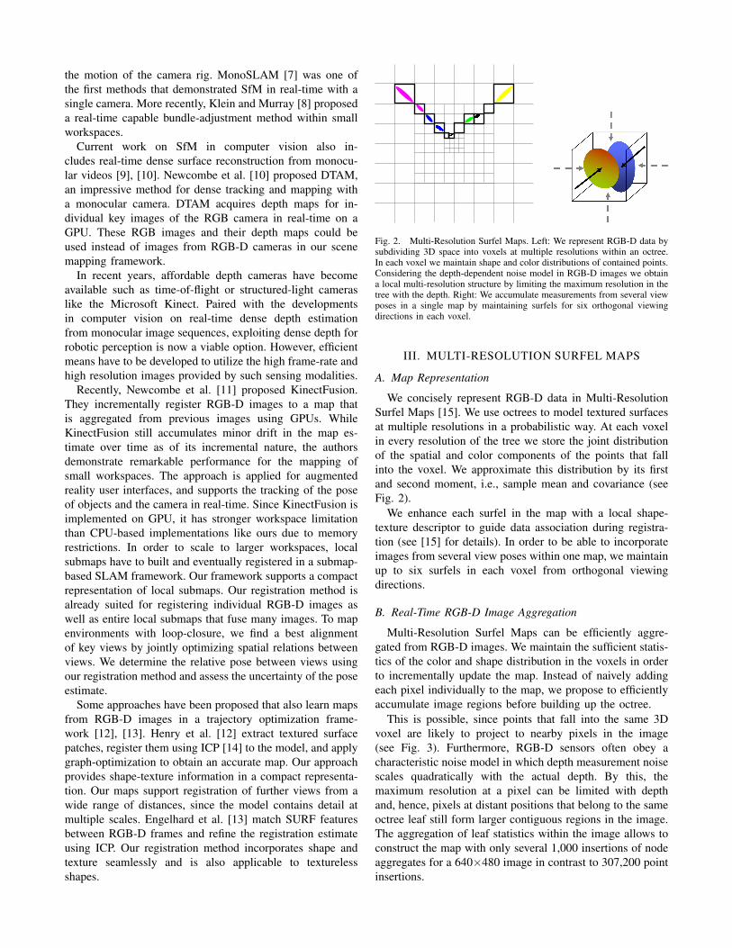
Fig. 2. Multi-Resolution Surfel Maps. Left: We represent RGB-D data bysubdividing 3D space into voxels at multiple resolutions within an octree.In each voxel we maintain shape and color distributions of contained points.Considering the depth-dependent noise model in RGB-D images we obtaina local multi-resolution structure by limiting the maximum resolution in thetree with the depth. Right: We accumulate measurements from several viewposes in a single map by maintaining surfels for six orthogonal viewingdirections in each voxel.
III. MULTI-RESOLUTION SURFEL MAPS
A. Map Representation
We concisely represent RGB-D data in Multi-ResolutionSurfel Maps [15]. We use octrees to model textured surfacesat multiple resolutions in a probabilistic way. At each voxelin every resolution of the tree we store the joint distributionof the spatial and color components of the points that fallinto the voxel. We approximate this distribution by its firstand second moment, i.e., sample mean and covariance (seeFig. 2).
We enhance each surfel in the map with a local shape-texture descriptor to guide data association during registra-tion (see [15] for details). In order to be able to incorporateimages from several view poses within one map, we maintainup to six surfels in each voxel from orthogonal viewingdirections.
B. Real-Time RGB-D Image Aggregation
Multi-Resolution Surfel Maps can be efficiently aggre-gated from RGB-D images. We maintain the sufficient statis-tics of the color and shape distribution in the voxels in orderto incrementally update the map. Instead of naively addingeach pixel individually to the map, we propose to efficientlyaccumulate image regions before building up the octree.
This is possible, since points that fall into the same 3Dvoxel are likely to project to nearby pixels in the image(see Fig. 3). Furthermore, RGB-D sensors often obey acharacteristic noise model in which depth measurement noisescales quadratically with the actual depth. By this, themaximum resolution at a pixel can be limited with depthand, hence, pixels at distant positions that belong to the sameoctree leaf still form larger contiguous regions in the image.The aggregation of leaf statistics within the image allows toconstruct the map with only several 1,000 insertions of nodeaggregates for a 640×480 image in contrast to 307,200 pointinsertions.
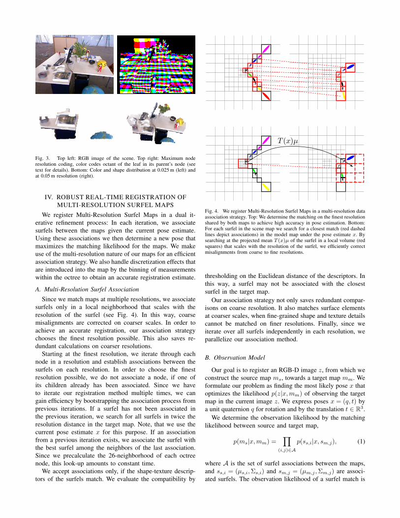
Fig. 3. Top left: RGB image of the scene. Top right: Maximum noderesolution coding, color codes octant of the leaf in its parent’s node (seetext for details). Bottom: Color and shape distribution at 0.025 m (left) andat 0.05 m resolution (right).
IV. ROBUST REAL-TIME REGISTRATION OFMULTI-RESOLUTION SURFEL MAPS
We register Multi-Resolution Surfel Maps in a dual it-erative refinement process: In each iteration, we associatesurfels between the maps given the current pose estimate.Using these associations we then determine a new pose thatmaximizes the matching likelihood for the maps. We makeuse of the multi-resolution nature of our maps for an efficientassociation strategy. We also handle discretization effects thatare introduced into the map by the binning of measurementswithin the octree to obtain an accurate registration estimate.
A. Multi-Resolution Surfel Association
Since we match maps at multiple resolutions, we associatesurfels only in a local neighborhood that scales with theresolution of the surfel (see Fig. 4). In this way, coarsemisalignments are corrected on coarser scales. In order toachieve an accurate registration, our association strategychooses the finest resolution possible. This also saves re-dundant calculations on coarser resolutions.
Starting at the finest resolution, we iterate through eachnode in a resolution and establish associations between thesurfels on each resolution. In order to choose the finestresolution possible, we do not associate a node, if one ofits children already has been associated. Since we haveto iterate our registration method multiple times, we cangain efficiency by bootstrapping the association process fromprevious iterations. If a surfel has not been associated inthe previous iteration, we search for all surfels in twice theresolution distance in the target map. Note, that we use thecurrent pose estimate x for this purpose. If an associationfrom a previous iteration exists, we associate the surfel withthe best surfel among the neighbors of the last association.Since we precalculate the 26-neighborhood of each octreenode, this look-up amounts to constant time.
We accept associations only, if the shape-texture descrip-tors of the surfels match. We evaluate the compatibility by
Fig. 4. We register Multi-Resolution Surfel Maps in a multi-resolution dataassociation strategy. Top: We determine the matching on the finest resolutionshared by both maps to achieve high accuracy in pose estimation. Bottom:For each surfel in the scene map we search for a closest match (red dashedlines depict associations) in the model map under the pose estimate x. Bysearching at the projected mean T (x)µ of the surfel in a local volume (redsquares) that scales with the resolution of the surfel, we efficiently correctmisalignments from coarse to fine resolutions.
thresholding on the Euclidean distance of the descriptors. Inthis way, a surfel may not be associated with the closestsurfel in the target map.
Our association strategy not only saves redundant compar-isons on coarse resolution. It also matches surface elementsat coarser scales, when fine-grained shape and texture detailscannot be matched on finer resolutions. Finally, since weiterate over all surfels independently in each resolution, weparallelize our association method.
B. Observation Model
Our goal is to register an RGB-D image z, from which weconstruct the source map ms, towards a target map mm. Weformulate our problem as finding the most likely pose x thatoptimizes the likelihood p(z|x,mm) of observing the targetmap in the current image z. We express poses x = (q, t) bya unit quaternion q for rotation and by the translation t ∈ R3.
We determine the observation likelihood by the matchinglikelihood between source and target map,
p(ms|x,mm) =∏
(i,j)∈A
p(ss,i|x, sm,j), (1)
where A is the set of surfel associations between the maps,and ss,i = (µs,i,Σs,i) and sm,j = (µm,j ,Σm,j) are associ-ated surfels. The observation likelihood of a surfel match is
the difference of the surfels under their normal distributions,
p(ss,i|x, sm,j) = N (di,j(x); 0,Σi,j(x)) ,
di,j(x) := µm,j − T (x)µs,i,
Σi,j(x) := Σm,j +R(x)Σs,iR(x)T ,
(2)
where T (x) is the homogeneous transformation matrix forthe pose estimate x and R(x) is its rotation matrix. Wemarginalize the surfel distributions for the spatial dimen-sions.
Note that due to the difference in view poses between theimages, the scene content is differently discretized betweenthe maps. We compensate for inaccuracies due to discretiza-tion effects by trilinear interpolation. This is possible, whena scene surfel ss,i is directly associated with the modelsurfel sm;j in the octree node at the projected position of thescene surfel T (x)µs,i. Instead of directly using the associatedmodel surfel sm,j in the observation likelihood (eq. (2)),we consider the surfel representation in the model map asa Gaussian Mixture model, and determine mean and covari-ance of the model surfel at the projected position T (x)µs,ithrough trilinear interpolation of neighboring surfels in themodel map.
C. Pose Optimization
We optimize the observation log likelihood
J(x) =∑
(i,j)∈A
log(|Σi,j(x)|) + dTi,j(x)Σ−1i,j (x)di,j(x) (3)
for the pose x in a multi-stage process combining gradientdescent and Newton’s method.
Since gradient descent converges only linearly, we useNewton’s method to find a pose with high precision. Forrobust initialization, we first run several iterations of gradientdescent to obtain a pose estimate close to a minimum of thelog-likelihood.
In each step, we determine new surfel associations in thecurrent pose estimate. We weight each surfel associationaccording to the similarity in the shape-texture descriptors.Our method typically converges within 10-20 iterations ofgradient descent and 5-10 iterations of Newton’s methodto a precise estimate. We parallelize the evaluation of thegradients and the Hessian matrix for each surfel which yieldsa significant speed-up on multi-core CPUs.
D. Estimation of Pose Uncertainty
We obtain an estimate of the observation covariance usinga closed-form approximation [16],
Σ(x) ≈(∂2J
∂x2
)−1∂2J
∂z∂xΣ(z)
∂2J
∂z∂x
T (∂2J
∂x2
)−1, (4)
where x is the pose estimate, z denotes the associatedsurfels in both maps, and Σ(z) is given by the covarianceof the surfels. The covariance estimate of the relative posebetween the maps captures uncertainty along unobservabledimensions, for instance, if the maps view a planar surface.
V. ON-LINE TRAJECTORY OPTIMIZATION
We will now describe our method for simultaneous local-ization and mapping. While the camera moves through thescene, we obtain a trajectory estimate using our registrationmethod. Since small registration errors may accumulate insignificant pose drift over time, we establish and optimize agraph of probabilistic spatial relations between similar viewposes. We denote a view pose in the graph as key view.We propose a randomized method to add spatial constraintsbetween similar views during on-line operation. By this, wealso detect the closure of trajectory loops.
A. Incremental Generation of Key View Graph
We register the current frame to the closest key view (thereference key view) in order to keep track of the camera. Wemeasure distance in translation and rotation between viewposes. At large distances, we add a new key view for thecurrent frame to the graph. This also adds a spatial relationbetween the new key view and its reference key view.
B. Constraint Detection
After each image update, we check for a new constraintfor the current reference key view. We determine for all un-established constraints of the current reference key view vrefto other key views v a probability
pchk(v) = N(d(vref, v); 0, σ2
d
)· N
(|α(vref, v)| ; 0, σ2
α
)(5)
that depends on the linear and rotational distances d(vref, v)and |α(vref, v)| of the key view poses, respectively. Wesample a key view v according to pchk(v) and determine therelative pose of the key views using our registration method.
In order to validate the matching of the key views, wedetermine their matching likelihood under the pose estimate.For each surfel in one of the key views, we find the bestmatching surfel in the second view. We directly take intoaccount the consistency of the surface normals betweenthe surfels and therefore determine the matching likelihoodof the surfels as the product of the likelihood under theirdistributions and under a normal distribution in the anglebetween their normals. We assign a minimum likelihoodto all surfels with a worse match or without a match. Inthis way, the matching likelihood accounts for the overlapbetween the views. This likelihood is directional and, hence,we evaluate it in both directions.
Since the matching likelihood depends on the observedscene content, we cannot use a global threshold for decidingif a constraint should be added. Instead we require thematching likelihood of a new constraint to be at least afraction of the matching likelihood for the initial constraintof the key view. This constraint has been established throughtracking from the referred key view and is thus assumed tobe consistent.
C. Graph Optimization
Our probabilistic registration method provides a mean andcovariance estimate for each spatial relation. We obtain the
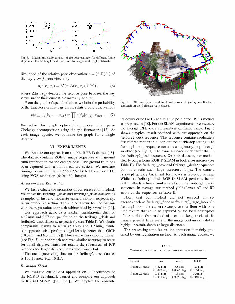
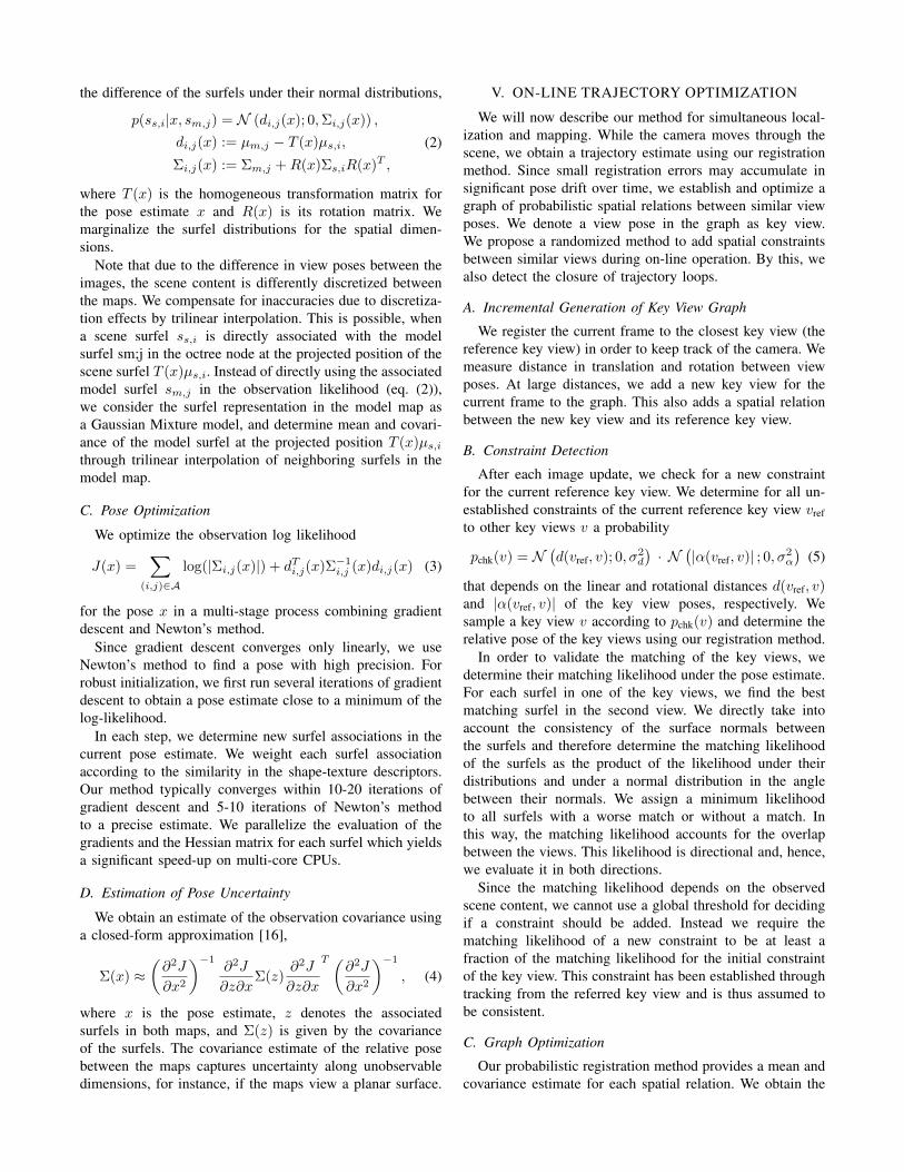
Fig. 5. Median translational error of the pose estimate for different frameskips k on the freiburg1_desk (left) and freiburg2_desk (right) dataset.
likelihood of the relative pose observation z = (x̂,Σ(x̂)) ofthe key view j from view i by
p(x̂|xi, xj) = N (x̂; ∆(xi, xj),Σ(x̂)) , (6)
where ∆(xi, xj) denotes the relative pose between the keyviews under their current estimates xi and xj .
From the graph of spatial relations we infer the probabilityof the trajectory estimate given the relative pose observations
p(x1,...,N |x̂1, . . . , x̂M ) ∝∏k
p(x̂k|xi(k), xj(k)). (7)
We solve this graph optimization problem by sparseCholesky decomposition using the g2o framework [17]. Ateach image update, we optimize the graph for a singleiteration.
VI. EXPERIMENTS
We evaluate our approach on a public RGB-D dataset [18].The dataset contains RGB-D image sequences with groundtruth information for the camera pose. The ground truth hasbeen captured with a motion capture system. We measuretimings on an Intel Xeon 5650 2,67 GHz Hexa-Core CPUusing VGA resolution (640×480) images.
A. Incremental Registration
We first evaluate the properties of our registration method.We chose the freiburg1_desk and freiburg2_desk datasets asexamples of fast and moderate camera motion, respectively,in an office-like setting. The choice allows for comparisonwith the registration approach (abbreviated by warp) in [19].
Our approach achieves a median translational drift of4.62 mm and 2.27 mm per frame on the freiburg1_desk andfreiburg2_desk datasets, respectively (see Table I). We obtaincomparable results to warp (5.3 mm and 1.5 mm), whileour approach also performs significantly better than GICP(10.3 mm and 6.3 mm [19]). However, when skipping frames(see Fig. 5), our approach achieves similar accuracy to warpfor small displacements, but retains the robustness of ICPmethods for larger displacements when warp fails.
The mean processing time on the freiburg2_desk datasetis 100,11 msec (ca. 10 Hz).
B. Indoor SLAM
We evaluate our SLAM approach on 11 sequences ofthe RGB-D benchmark dataset and compare our approachto RGB-D SLAM ([20], [21]). We employ the absolute
Fig. 6. 3D map (5 cm resolution) and camera trajectory result of ourapproach on the freiburg2_desk dataset.
trajectory error (ATE) and relative pose error (RPE) metricsas proposed in [18]. For the SLAM experiments, we measurethe average RPE over all numbers of frame skips. Fig. 6shows a typical result obtained with our approach on thefreiburg2_desk sequence. This sequence contains moderatelyfast camera motion in a loop around a table-top setting. Thefreiburg1_room sequence contains a trajectory loop throughan office (see Fig. 1). The camera moves much faster than inthe freiburg2_desk sequence. On both datasets, our methodclearly outperforms RGB-D SLAM in both error metrics (seeTable II). The freiburg1_desk and freiburg1_desk2 sequencesdo not contain such large trajectory loops. The camerais swept quickly back and forth over a table-top setting.While on freiburg1_desk RGB-D SLAM performs better,both methods achieve similar results on the freiburg1_desk2sequence. In average, our method yields lower AT and RPerrors on the sequences in Table II.
Note, that our method did not succeed on se-quences such as freiburg1_floor or freiburg2_large_loop. Onfreiburg1_floor the camera sweeps over a floor with onlylittle texture that could be captured by the local descriptorsof the surfels. Our method also cannot keep track of thecamera pose, if large parts of the image contain no valid orhighly uncertain depth at large distances.
The processing time for on-line operation is mainly gov-erned by our registration method. At each image update, we
TABLE ICOMPARISON OF MEDIAN POSE DRIFT BETWEEN FRAMES.
dataset ours warp GICP
freiburg1_desk 4.62 mm 5.3 mm 10.3 mm0.0092 deg 0.0065 deg 0.0154 deg
freiburg2_desk 2.27 mm 1.5 mm 6.3 mm0.0041 deg 0.0027 deg 0.0060 deg

Fig. 7. Projection onto the x-y-plane of ground truth and trajectory estimateof our approach on the freiburg2_desk dataset.
have to register 2 pairs of views. First, we keep track ofthe current sensor pose by aligning the image to the closestkey view in the map. Our randomized constraint detectionmethod invokes a second registration at each image update.In our experiments, one iteration of graph optimization couldbe performed in the order of 1 ms.
VII. CONCLUSIONS
We proposed a novel approach to SLAM with RGB-Dcameras in indoor environments. In our method, we com-press the image content efficiently in 3D Multi-ResolutionSurfel Maps. This map representation is well suited foraccurate real-time registration by directly matching surfelsand optimizing their matching likelihood. Our registrationmethod also provides an estimate of pose uncertainty. Weuse this information to smooth the joint trajectory estimatein a probabilistic optimization framework. We present meansto establish spatial relations between similar key views andto detect loop-closures during on-line operation.
Our approach yields accurate estimates of map and trajec-tory. On a benchmark dataset we could demonstrate, that
TABLE IICOMPARISON OF OUR SLAM APPROACH WITH RGB-D SLAM IN
ABSOLUTE TRAJECTORY (ATE) AND RELATIVE POSE ERROR (RPE).
RMSE ATE in m RMSE RPE in m
dataset ours RGB-DSLAM
ours RGB-DSLAM
freiburg1_360 0.069 0.079 0.110 0.103freiburg1_desk2 0.049 0.043 0.090 0.102freiburg1_desk 0.043 0.023 0.075 0.049freiburg1_plant 0.026 0.091 0.044 0.142freiburg1_room 0.069 0.084 0.139 0.219freiburg1_rpy 0.027 0.026 0.040 0.042freiburg1_teddy 0.039 0.076 0.073 0.138freiburg1_xyz 0.013 0.014 0.020 0.021freiburg2_desk 0.052 0.095 0.099 0.143freiburg2_rpy 0.024 0.019 0.034 0.026freiburg2_xyz 0.020 0.026 0.030 0.037
average 0.039 0.052 0.069 0.093
in most cases the accuracy of our method is similar oreven better compared to a state-of-the-art approach that mapssparse image features. Since our method strongly relies ondense depth, it is less accurate, if large parts of the imagehave no valid or only highly uncertain depth measurements.We will therefore combine our dense depth registrationmethod with the alignment of point or contour features.
In future work, we will further investigate loop-closure de-tection for long trajectory loops through appearance modal-ities. We will also incorporate graph management strategiessuch as sub-graph hierarchies and graph pruning to allow forlong-term operation.
REFERENCES
[1] G. Grisetti, C. Stachniss, and W. Burgard, “Improved techniques forgrid mapping with Rao-Blackwellized particle filters,” IEEE Transac-tions on Robotics, 2007.
[2] A. Nuechter, K. Lingemann, J. Hertzberg, and H. Surmann, “6DSLAM with approximate data association,” in Proc. of the Int. Conf.on Advanced Robotics, 2005.
[3] M. Magnusson, T. Duckett, and A. Lilienthal, “Scan registration forautonomous mining vehicles using 3D-NDT,” J. of Field Rob., 2007.
[4] A. Segal, D. Haehnel, and S. Thrun, “Generalized-ICP,” in Proc. ofRobotics: Science and Systems, 2009.
[5] S. Se, D. Lowe, and J. Little, “Vision-based mobile robot localizationand mapping using scale-invariant features,” in Proc. of the IEEE Int.Conf. on Robotics and Automation (ICRA), 2001.
[6] K. Konolige, J. Bowman, J. Chen, P. Mihelich, M. Calonder, V. Lepetit,and P. Fua, “View-based maps,” Int. J. of Robotics Research, 2010.
[7] A. J. Davison, I. D. Reid, N. D. Molton, and O. Stasse, “MonoSLAM:Real-time single camera SLAM,” IEEE Trans. Pattern Analysis andMachine Intelligence, 2007.
[8] G. Klein and D. Murray, “Parallel tracking and mapping for smallAR workspaces,” in Proc. of IEEE/ACM Int. Symp. on Mixed andAugmented Reality (ISMAR), 2007.
[9] J. Stuehmer, S. Gumhold, and D. Cremers, “Real-time dense geometryfrom a handheld camera,” in Proc. of the DAGM Conference, 2010.
[10] R. Newcombe, S. Lovegrove, and A. Davison, “DTAM: Dense trackingand mapping in real-time,” in Proc. of the Int. Conf. on ComputerVision (ICCV), 2011.
[11] R. A. Newcombe, S. Izadi, O. Hilliges, D. Molyneaux, D. Kim, A. J.Davison, P. Kohli, J. Shotton, S. Hodges, and A. Fitzgibbon, “Kinect-Fusion: real-time dense surface mapping and tracking,” in Proc. of theInt. Symposium on Mixed and Augmented Reality (ISMAR), 2011.
[12] P. Henry, M. Krainin, E. Herbst, X. Ren, and D. Fox, “Rgb-d mapping:Using depth cameras for dense 3d modeling of indoor environments,”in Proc. of Int. Symposium on Experimental Robotics (ISER), 2010.
[13] N. Engelhard, F. Endres, J. Hess, J. Sturm, and W. Burgard, “Real-time 3D visual SLAM with a hand-held camera,” in Proc. of RGB-DWorkshop on 3D Perception in Robotics at Europ. Rob. Forum, 2011.
[14] P. J. Besl and N. D. McKay, “A method for registration of 3-D shapes,”IEEE Trans. on Pattern Analysis and Machine Intelligence, 1992.
[15] J. Stückler and S. Behnke, “Robust real-time registration of RGB-Dimages using multi-resolution surfel representations,” in Proc. of the7th German Conference on Robotics (ROBOTIK), 2012.
[16] A. Censi, “An accurate closed-form estimate of ICP’s covariance,” inProc. of IEEE Int. Conf. on Robotics and Automation (ICRA), 2007.
[17] R. Kuemmerle, G. Grisetti, H. Strasdat, K. Konolige, and W. Burgard,“g2o: A general framework for graph optimization,” in Proc. of theIEEE Int. Conf. on Robotics and Automation (ICRA), 2011.
[18] J. Sturm, N. Engelhard, F. Endres, W. Burgard, and D. Cremers, “Abenchmark for the evaluation of rgb-d slam systems,” in Proc. of theIEEE Int. Conf. on Intelligent Robot Systems (IROS), 2012.
[19] F. Steinbruecker, J. Sturm, and D. Cremers, “Real-time visual odom-etry from dense RGB-D images,” in Workshop on Live Dense Recon-struction with Moving Cameras at ICCV, 2011.
[20] F. Endres, J. Hess, N. Engelhard, J. Sturm, D. Cremers, and W. Bur-gard, “An evaluation of the RGB-D SLAM system,” in Proc. of theIEEE Int. Conf. on Robotics and Automation (ICRA), 2012.
[21] F. Endres, J. Hess, N. Engelhard, J. Sturm, , and W. Burgard, “6Dvisual SLAM for RGB-D sensors,” at - Automatisierungstechnik, 2012.