integrating biodiversity into adsdpp processes and the
TRANSCRIPT
1
Integrating Biodiversity Into ADSDPP Processes and the Biodiversity -
Enhanced ADSDPP into the Mandated Plans of Host
Local Governments
Biodiversity Partnership
Department of Environment and Natural Resources
Global EnvironmentFacility
United NationsDevelopment Programme
2
Published by:
Department of Environment and Natural Resources – Biodiversity Management BureauNinoy Aquino Parks and Wildlife Center, North Avenue, Diliman, 1100 Quezon City
Global Environment Facility1899 Pennsylvania Ave NW, Washington, DC 20006, United States
United Nations Development Programme30th Floor, Yuchengco Tower, RCBC Plaza, 6819 Ayala Av-enue, 1226 Makati City
(2017)
Recommended citation:
Biodiversity Management Bureau. Manual of Procedures on Integrating Biodiversity Into ADSDPP Processes and the Biodiversity - Enhanced ADSDPP into the Mandated Plans of Host Local Governments. Department of Environment and Natural Resources-Biodiversity Management Bureau, United Nations Development Programme - Global Environment Facility. Quezon City, Philippines.
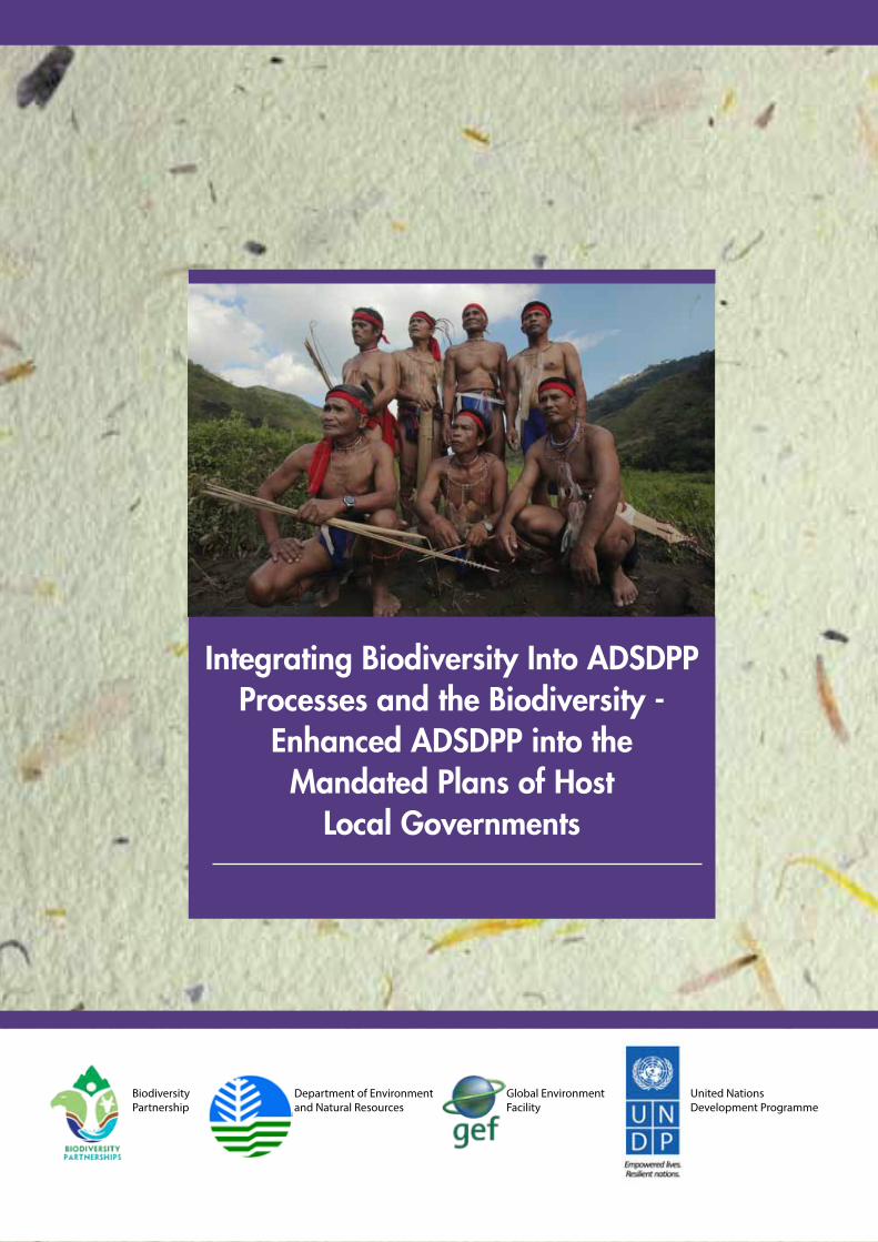
Photo Credits: Dave de Vera, PAFID, New CAPP Project, NPD-BMB
ISBN ________________________
Copyright © 2017 by the Department of Environment and Natural Resources – Biodiversity Management Bureau, United Nations Development Programme - Global Environ-ment Facility.
All rights reserved.
Any reproduction of this publication is authorized only for educational or other non-commercial purposes and must credit the publisher and copyright owner.
Printed in the Philippines
3
Integrating Biodiversity Into ADSDPP Processes and the Biodiversity -
Enhanced ADSDPP into the Mandated Plans of Host
Local Governments
Biodiversity Partnership
Department of Environment and Natural Resources
Global EnvironmentFacility
United NationsDevelopment Programme
4
2
TABLEOFCONTENTS
PartIMANUALOFPROCEDURES………………………………………………... 1PartIIIDENTIFYINGANDDELINEATINGOVERLAPPEDAREASBETWEENPROTECTEDAREASANDINDIGENOUSPEOPLE’SCOMMUNITIES………..
4
ActivityI–IdentifyingallPAandADoverlapsatthenationalorregionallevel…… 4Activity II – Delineation and Demarcation of the Boundaries of the OverlappedAreas…………………………………………………………………………………..
5
PartIII………………………………………………………………………………… 6ScenarioA-HARMONIZEDMANAGEMENTPLAN……………………………. 6ScenarioB-MAKINGTHEPROTECTEDAREAMANAGEMENTPLANSENSITIVETOINDIGENOUSPEOPLE’SRIGHTSANDREQUIREMENTS…...
21
Activity1.RevisingthePAMPZoningScheme…………………………………….. 24Activity2.ManagingtheIPSettlements,LivelihoodandInfrastructureSupport…… 30ScenarioC-FORMULATINGABIODIVERSITY-ENHANCEDANCESTRALDOMAINSUSTAINABLEDEVELOPMENTANDPROTECTIONPLAN……….
32
ScenarioDPLANNINGFORTHEINDIGENOUSCOMMUNITY-CONSERVEDAREA………………………………………………………………………………….
43
4.1Planningprocessforanindigenouscommunity-conservedarea…………………. 434.2StepsinICCAPlanning…………………………………………………………... 44PartIVINTEGRATINGTHEBD-ENHANCEDADSDPPANDTHEHARMONIZEDPAMPANDADSDPPINLOCALGOVERNMENTPLANNING
51
1.LegalMandate……………………………………………………………………… 512.RationaleforIntegration…………………………………………………………… 513. DeterminingatWhatLevelofLGUtoIntegratetheADSDPP/PAMP…………… 524. ApproachestoPlanIntegration…………………………………………………….. 53PartVAPPENDICES…………………………………………………….. 63
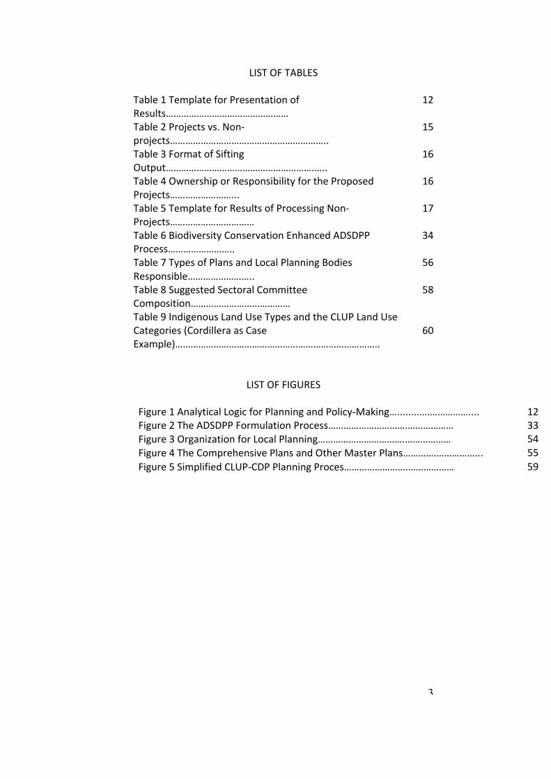
5
3
LISTOFTABLESTable1TemplateforPresentationofResults…………………………………………
12
Table2Projectsvs.Non-projects……………………………………………………..
15
Table3FormatofSiftingOutput………………………………………………….…..
16
Table4OwnershiporResponsibilityfortheProposedProjects……………………...
16
Table5TemplateforResultsofProcessingNon-Projects……………………………
17
Table6BiodiversityConservationEnhancedADSDPPProcess……………………..
34
Table7TypesofPlansandLocalPlanningBodiesResponsible……………………..
56
Table8SuggestedSectoralCommitteeComposition…………………………………
58
Table9IndigenousLandUseTypesandtheCLUPLandUseCategories(CordilleraasCaseExample)……………………………………………………………………..
60
LISTOFFIGURESFigure1AnalyticalLogicforPlanningandPolicy-Making…........….…………….... 12Figure2TheADSDPPFormulationProcess………………………….……………… 33Figure3OrganizationforLocalPlanning…………………………….……………… 54Figure4TheComprehensivePlansandOtherMasterPlans………….……………... 55Figure5SimplifiedCLUP-CDPPlanningProces…………………….……………… 59
6
4
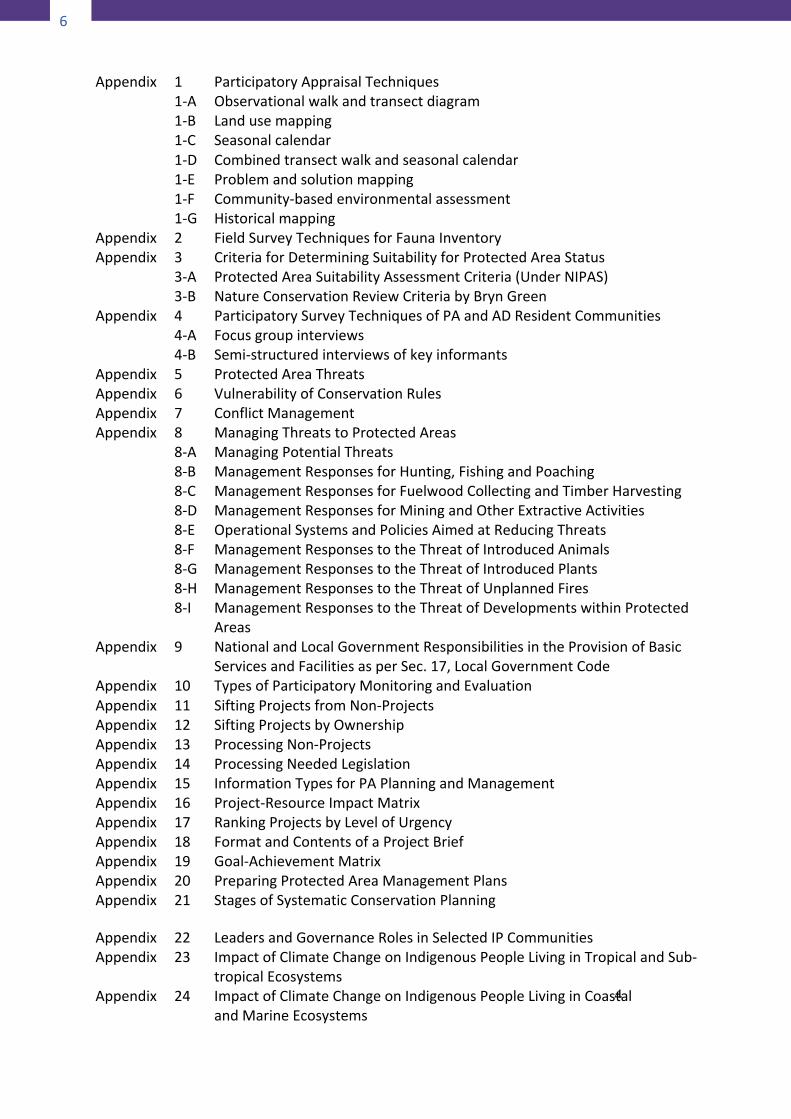
Appendix 11-A1-B1-C1-D1-E1-F1-G
ParticipatoryAppraisalTechniquesObservationalwalkandtransectdiagramLandusemappingSeasonalcalendarCombinedtransectwalkandseasonalcalendarProblemandsolutionmappingCommunity-basedenvironmentalassessmentHistoricalmapping
Appendix 2 FieldSurveyTechniquesforFaunaInventoryAppendix 3
3-A3-B
CriteriaforDeterminingSuitabilityforProtectedAreaStatusProtectedAreaSuitabilityAssessmentCriteria(UnderNIPAS)NatureConservationReviewCriteriabyBrynGreen
Appendix 44-A4-B
ParticipatorySurveyTechniquesofPAandADResidentCommunitiesFocusgroupinterviewsSemi-structuredinterviewsofkeyinformants
Appendix 5 ProtectedAreaThreatsAppendix 6 VulnerabilityofConservationRulesAppendix 7 ConflictManagementAppendix 8
8-A8-B8-C8-D8-E8-F8-G8-H8-I
ManagingThreatstoProtectedAreasManagingPotentialThreatsManagementResponsesforHunting,FishingandPoachingManagementResponsesforFuelwoodCollectingandTimberHarvestingManagementResponsesforMiningandOtherExtractiveActivitiesOperationalSystemsandPoliciesAimedatReducingThreatsManagementResponsestotheThreatofIntroducedAnimalsManagementResponsestotheThreatofIntroducedPlantsManagementResponsestotheThreatofUnplannedFiresManagementResponsestotheThreatofDevelopmentswithinProtectedAreas
Appendix 9 NationalandLocalGovernmentResponsibilitiesintheProvisionofBasicServicesandFacilitiesasperSec.17,LocalGovernmentCode
Appendix 10 TypesofParticipatoryMonitoringandEvaluationAppendix 11 SiftingProjectsfromNon-ProjectsAppendix 12 SiftingProjectsbyOwnershipAppendix 13 ProcessingNon-ProjectsAppendix 14 ProcessingNeededLegislationAppendix 15 InformationTypesforPAPlanningandManagementAppendix 16 Project-ResourceImpactMatrixAppendix 17 RankingProjectsbyLevelofUrgencyAppendix 18 FormatandContentsofaProjectBriefAppendix 19 Goal-AchievementMatrixAppendix 20 PreparingProtectedAreaManagementPlansAppendix 21 StagesofSystematicConservationPlanning
5
AppendixAppendixAppendix
222324
LeadersandGovernanceRolesinSelectedIPCommunitiesImpactofClimateChangeonIndigenousPeopleLivinginTropicalandSub-tropicalEcosystemsImpactofClimateChangeonIndigenousPeopleLivinginCoastalandMarineEcosystems
7
4
Appendix 11-A1-B1-C1-D1-E1-F1-G
ParticipatoryAppraisalTechniquesObservationalwalkandtransectdiagramLandusemappingSeasonalcalendarCombinedtransectwalkandseasonalcalendarProblemandsolutionmappingCommunity-basedenvironmentalassessmentHistoricalmapping
Appendix 2 FieldSurveyTechniquesforFaunaInventoryAppendix 3
3-A3-B
CriteriaforDeterminingSuitabilityforProtectedAreaStatusProtectedAreaSuitabilityAssessmentCriteria(UnderNIPAS)NatureConservationReviewCriteriabyBrynGreen
Appendix 44-A4-B
ParticipatorySurveyTechniquesofPAandADResidentCommunitiesFocusgroupinterviewsSemi-structuredinterviewsofkeyinformants
Appendix 5 ProtectedAreaThreatsAppendix 6 VulnerabilityofConservationRulesAppendix 7 ConflictManagementAppendix 8
8-A8-B8-C8-D8-E8-F8-G8-H8-I
ManagingThreatstoProtectedAreasManagingPotentialThreatsManagementResponsesforHunting,FishingandPoachingManagementResponsesforFuelwoodCollectingandTimberHarvestingManagementResponsesforMiningandOtherExtractiveActivitiesOperationalSystemsandPoliciesAimedatReducingThreatsManagementResponsestotheThreatofIntroducedAnimalsManagementResponsestotheThreatofIntroducedPlantsManagementResponsestotheThreatofUnplannedFiresManagementResponsestotheThreatofDevelopmentswithinProtectedAreas
Appendix 9 NationalandLocalGovernmentResponsibilitiesintheProvisionofBasicServicesandFacilitiesasperSec.17,LocalGovernmentCode
Appendix 10 TypesofParticipatoryMonitoringandEvaluationAppendix 11 SiftingProjectsfromNon-ProjectsAppendix 12 SiftingProjectsbyOwnershipAppendix 13 ProcessingNon-ProjectsAppendix 14 ProcessingNeededLegislationAppendix 15 InformationTypesforPAPlanningandManagementAppendix 16 Project-ResourceImpactMatrixAppendix 17 RankingProjectsbyLevelofUrgencyAppendix 18 FormatandContentsofaProjectBriefAppendix 19 Goal-AchievementMatrixAppendix 20 PreparingProtectedAreaManagementPlansAppendix 21 StagesofSystematicConservationPlanning
5
AppendixAppendixAppendix
222324
LeadersandGovernanceRolesinSelectedIPCommunitiesImpactofClimateChangeonIndigenousPeopleLivinginTropicalandSub-tropicalEcosystemsImpactofClimateChangeonIndigenousPeopleLivinginCoastalandMarineEcosystems
6
PartI
MANUALOFPROCEDURES
INTRODUCTIONThis Manual of Procedures is a companion document to the“Framework for Preparing the Biodiversity-Enhanced AncestralDomain Sustainable Development and Protection Plan”. Itcontains the details to the procedural steps, methods andtechniques of data generation and analysis, plan formulationprocess and related matters referred to in the Frameworkpertaining to planning the management of areas whereindigenous communitiesoverlapwith key conservationareas,orviceversa.
1 Manual ofProcedures
8
7
INTENDEDUSERSOFTHEMANUALThe principal users of this Manual are the four agencies of thenational government that have oversight functions on theplanning of ancestral domains, protected areas, and localgovernments namely the National Commission on IndigenousPeople (NCIP), the Department of Environment and NaturalResources (DENR), the Department of Interior and LocalGovernments (DILG), and the Housing and Land Use RegulatoryBoard(HLURB).Itshouldlikewisebemadeavailabletoprovinces,cities, municipalities and barangays where there are protectedareas and indigenous communities within their territorialjurisdiction to serve as an added resource in the preparation oftheir mandated plans. Other interested parties, particularly civilsociety organizations and aid-granting institutions may also findthisManualhelpful.STRUCTUREANDCONTENTSOFTHEMANUALThis Manual consists of five main sections. The first part whichincludes this introductory section lays the outline or road mapthatdirectstheusertospecificportionsofthewholedocument.In a sense, the roadmap serves as table of contents and indexrolledintoone.Thesecondpartoutlinesthetechnicalprocessofidentifying, classifying, delineating on themap and demarcatingon the ground theareas thatwill be the subjectof the typeofplanning interventions contemplated in this Manual. The thirdpartisthesubstantivepartofthisManual.Itcontainsthedetailedguidelinestopreparingtheparticulartypeofplanneededfortheeffective governanceof areas that areearmarked forprotectionbut which harbor within their borders indigenous people’scommunities or, conversely, ancestral domains that happen tocontain areas and resources that need to be placed underprotectionstatus.Therearefourvariantsoftheplanningprocessdepending on the realities obtaining in the area of application.One variant, denoted as Scenario A pertains to the overlappedareabetween aNIPASprotected area andan ancestral domainwithaCADT.The secondvariant, ScenarioB, applies toaNIPASprotected area overlapping with non-CADT indigenouscommunities. Scenario C, refers to the overlap between anancestral domain with CADT and a non-NIPAS protected area.Scenario D pertains to conservation areas with residentindigenouscommunitiestheplanningofwhichisinitiatedbythecommunitiesthemselves.Thefourthpartpertainstotheprocess
9
7
INTENDEDUSERSOFTHEMANUALThe principal users of this Manual are the four agencies of thenational government that have oversight functions on theplanning of ancestral domains, protected areas, and localgovernments namely the National Commission on IndigenousPeople (NCIP), the Department of Environment and NaturalResources (DENR), the Department of Interior and LocalGovernments (DILG), and the Housing and Land Use RegulatoryBoard(HLURB).Itshouldlikewisebemadeavailabletoprovinces,cities, municipalities and barangays where there are protectedareas and indigenous communities within their territorialjurisdiction to serve as an added resource in the preparation oftheir mandated plans. Other interested parties, particularly civilsociety organizations and aid-granting institutions may also findthisManualhelpful.STRUCTUREANDCONTENTSOFTHEMANUALThis Manual consists of five main sections. The first part whichincludes this introductory section lays the outline or road mapthatdirectstheusertospecificportionsofthewholedocument.In a sense, the roadmap serves as table of contents and indexrolledintoone.Thesecondpartoutlinesthetechnicalprocessofidentifying, classifying, delineating on themap and demarcatingon the ground theareas thatwill be the subjectof the typeofplanning interventions contemplated in this Manual. The thirdpartisthesubstantivepartofthisManual.Itcontainsthedetailedguidelinestopreparingtheparticulartypeofplanneededfortheeffective governanceof areas that areearmarked forprotectionbut which harbor within their borders indigenous people’scommunities or, conversely, ancestral domains that happen tocontain areas and resources that need to be placed underprotectionstatus.Therearefourvariantsoftheplanningprocessdepending on the realities obtaining in the area of application.One variant, denoted as Scenario A pertains to the overlappedareabetween aNIPASprotected area andan ancestral domainwithaCADT.The secondvariant, ScenarioB, applies toaNIPASprotected area overlapping with non-CADT indigenouscommunities. Scenario C, refers to the overlap between anancestral domain with CADT and a non-NIPAS protected area.Scenario D pertains to conservation areas with residentindigenouscommunitiestheplanningofwhichisinitiatedbythecommunitiesthemselves.Thefourthpartpertainstotheprocess
8
ofmainstreamingtheseplans(orvariationsonthesamethematicplan) into themandated plans of local government units havingpolitical jurisdiction over the protected areas and ancestraldomainsinquestion.ThefifthandlastpartofthisManualwhichis normally considered non-substantive but nonetheless animportantone is thecompilationofappendices.Materialswhichare too long or which contain too many details that, whenincluded in themainbodyof the text,mightdisrupt the logicornarrativeflow,arebettershuntedintotheappendices.Usersarehoweverenjoinednottoignoreanyreferencetoanappendixforoften,thematerialintheappendixisintegraltothemaintextanditdemandsofthemalittlemoretimeanddedicatedattention.HOWTOUSETHEMANUALTogettheoptimumbenefitfromtheuseofthisManual,theendusersmust knowat theoutsetunderwhat situationor scenariotheyarepreparingaparticularplan.Toensurethattheydo,NCIPand PAWB should initially jointly identify the overlapped areasbetween ancestral domains and protected areas nationwidethrough the map overlay process as described in Part II of thisManual.Themapsshouldbeofsufficientlylargescalesothattheprovinces, municipalities and barangays straddled by the AD/PAcouldbeidentified.Havingdeterminedunderwhatscenariotheyareplanning,enduserswillnothaveahardtimeselectingwhichproceduralguidetofollowbecausethereisoneprocessguideforeach scenario. Brief features of each procedural guide are asfollows:IfplanningforanoverlappedarebetweenaNIPASprotectedareaandanancestraldomainwithCADT,usetheguideforpreparinga“Harmonized Management Plan” or Scenario A. The process isbased on the provisions of DENR-NCIP JMC 2007-01. Theassumptionhere iseither that thePAhasanexistingPAMPandtheADhasanADSDPP,or thatboth thePAMPandADSDPParenon-existent. The Harmonized Management Plan therefore is acompletely new plan covering only the overlapped area. Theelaboration of the process is as complete as possible so that itmayserveasasortoftemplatefortheotherscenarios.Thedatagathering tools and analytical techniques combine those ofrelevant sciences and customary participatory assessmentprocesses so that the discerning users can have the widestpossiblechoiceapplicabletoparticularconditionsontheground.
10
9
If the plan pertains to an area within a NIPAS protected areawhichis inhabitedbyindigenouspeoplewhoareeithermigrantsor resettled to the area, the approach is to make the existingPAMP sensitive to the ICCs/IPs or Scenario B. The planningprocess under this scenario is very much simplified. It involvesrevisionofthePAzoningschemeby incorporating intotheStrictProtection Zone all areas consideredby the IP as “no go zones”suchastheirburialgrounds,sacredgroves,huntinggrounds,andthe like. The Multiple Use Zone will also be revised byaccommodatingthecustomaryresourceusepracticesoftheIPasinherentlysustainableandgenerallyconsistentwithconservationobjectives. The procedure for giving formal recognition tocustomaryresourceusepracticesspelledout inDENR-NCIPJointAO2008-01isadoptedforthelatterpurpose.UnderScenarioC thesituation is thatanancestraldomainwithCADTharborswithinitsboundariesanimportantresourceorareathatneeds tobeplacedunderbiodiversity conservation regime.Assuming that there is already an ADSDPP for the ancestraldomain,theproperplanningapproachistoenhancetheADSDPPwith biodiversity conservation considerations. The process issimplified like inScenarioB. It involvesmanagementzoningthathas the same features as in Scenario B. Furthermore, importantadditional enhancements to the original ADSDPP process areintroduced, particularly on the aspect of extracting greatercommitmentofsupportfromtheLGUsandotherstakeholders.Thefourthsituation,ScenarioD,pertainstotheoverlapbetweennon-NIPAS protected areas and non-CADT ancestral domains.Often the initiative to conserve the area is taken by thecommunities within or around the area and is referred to as acommunity-conserved area (CCA). Consistent with the terms ofthis study, only CCAs with indigenous communities areconsidered, hence the name indigenous community-conservedarea(ICCA).The last step in every planning process under any of the abovescenarios is the integration of the plans into the plans andplanning systems of the local governments having territorialjurisdictionovertheplanningareas.Itwoulddowellforenduserstopursuetheprocessuptothislaststep.Finally, the frequent reference to the Appendices means thatsomestepsare found inall thevariationsof theprocess.Failure
10
toheedthereferencetoaparticularAppendix,onemightruntheriskofmissingsomeimportantstepsintheprocess.
11
9
If the plan pertains to an area within a NIPAS protected areawhichis inhabitedbyindigenouspeoplewhoareeithermigrantsor resettled to the area, the approach is to make the existingPAMP sensitive to the ICCs/IPs or Scenario B. The planningprocess under this scenario is very much simplified. It involvesrevisionofthePAzoningschemeby incorporating intotheStrictProtection Zone all areas consideredby the IP as “no go zones”suchastheirburialgrounds,sacredgroves,huntinggrounds,andthe like. The Multiple Use Zone will also be revised byaccommodatingthecustomaryresourceusepracticesoftheIPasinherentlysustainableandgenerallyconsistentwithconservationobjectives. The procedure for giving formal recognition tocustomaryresourceusepracticesspelledout inDENR-NCIPJointAO2008-01isadoptedforthelatterpurpose.UnderScenarioC thesituation is thatanancestraldomainwithCADTharborswithinitsboundariesanimportantresourceorareathatneeds tobeplacedunderbiodiversity conservation regime.Assuming that there is already an ADSDPP for the ancestraldomain,theproperplanningapproachistoenhancetheADSDPPwith biodiversity conservation considerations. The process issimplified like inScenarioB. It involvesmanagementzoningthathas the same features as in Scenario B. Furthermore, importantadditional enhancements to the original ADSDPP process areintroduced, particularly on the aspect of extracting greatercommitmentofsupportfromtheLGUsandotherstakeholders.Thefourthsituation,ScenarioD,pertainstotheoverlapbetweennon-NIPAS protected areas and non-CADT ancestral domains.Often the initiative to conserve the area is taken by thecommunities within or around the area and is referred to as acommunity-conserved area (CCA). Consistent with the terms ofthis study, only CCAs with indigenous communities areconsidered, hence the name indigenous community-conservedarea(ICCA).The last step in every planning process under any of the abovescenarios is the integration of the plans into the plans andplanning systems of the local governments having territorialjurisdictionovertheplanningareas.Itwoulddowellforenduserstopursuetheprocessuptothislaststep.Finally, the frequent reference to the Appendices means thatsomestepsare found inall thevariationsof theprocess.Failure
10
toheedthereferencetoaparticularAppendix,onemightruntheriskofmissingsomeimportantstepsintheprocess. 11
PartII
IDENTIFYINGANDDELINEATINGOVERLAPPEDAREASBETWEENPROTECTEDAREAS
ANDINDIGENOUSPEOPLE’SCOMMUNITIES
ActivityI–IdentifyingallPAandADoverlapsatthenationalorregionallevelTask1–ThematicMapping
a. DENR/PAWBdelineatesallkeybiodiversityareasclassifiedintoNIPASandnon-NIPAS
b. NCIPdelineatesallareaswheresignificantconcentrationsof IPs are found, classified into those already grantedCADTsorstillinprocessandthosenotlikelytogetCADTs.
Note: For purposes determining what amounts to“significantconcentration”of IPs, either or both of thefollowingcriteriamaybeused:
2 Identifying and Delineating Overlapped Areas Between Protected Areas andIndigenous People’s Communi-ties
12
12
• IPs constitute at least one percent (1.0%) of thelocalpopulation
• TheancestraldomainorclaimedhabitatofIPsisatleastfivepercent(5%)oftheLGUterritory
Task2–MapOverlayAnalysis
a. PAWB & NCIP overlay the thematic maps (a&b) andidentifyandtagorcolorcodetheoverlappedareas.
IPCommunity KEYBIODIVERSITYAREAS
NIPAS(A)
NON-NIPAS(B)
ADwithCADT(I) IA IBIParea
NoCADT(II)IIA IIB
b. PAWB & NCIP classify the overlapped areas under the
followingcategories: ScenarioA=IA+ADwithCADTandNIPASPA ScenarioB=IB+ADwithCADTandNon-NIPASPA ScenarioC=IIA+IPareawithnoCADTandNIPASPA ScenarioD=IIB+IPareawithnoCADTandNon-NIPASPA(ICCA)c. Foreachscenarioofoverlappedareaindicatethelocation
bynamingthe barangay/s, municipalities orprovince/sstraddled.
Activity II –Delineation andDemarcationof theBoundaries oftheOverlappedAreasActivity I produced four scenarios of areas characterized by theconvergence of protected areas and ancestral domains. Havingbeenidentifiedatthenational/regionallevel,thelocationofeachoverlappedarea isonly indicativeand lessprecise.Forpurposesof determining the appropriate governance regime for eachscenario, it is necessary to define the boundaries of theoverlappedareaswithgreaterprecision.Thisrequiresconductofgeodetic surveys at a large scale, preferably provincial or
13
municipal, using common survey instruments. Then to facilitateenforcementofregulations,boundariesshouldbedemarcatedontheground.Initiative forgeodetic surveys shallbe taken jointlyby theDENRwithNCIP inthecaseof IA; theDENRshall initiatethesurveyofcase and IIA with NCIP concurring; the NCIP shall take theinitiativeinthecaseofIBwithDENRconcurring;andinthecaseofIIB either of the two agencies shall take the lead depending onwhether biodiversity conservation or indigenous people’s rightsareofmoreimmediatepriorityconcern.Task1–Delineationofboundariesoftheoverlappedareasattheprovincialormunicipallevel
a. Using suitable instruments (GPS, transit, theodolite)establishthemetesandboundsoftheoverlappedarea.
b. Plot theboundariesonthemapandmakeprintedcopiesforconfirmationby,andinformationofallstakeholders.
Task2–Installationofboundarymarkersonthegroundoncetheconcernedpartiesareinagreement.
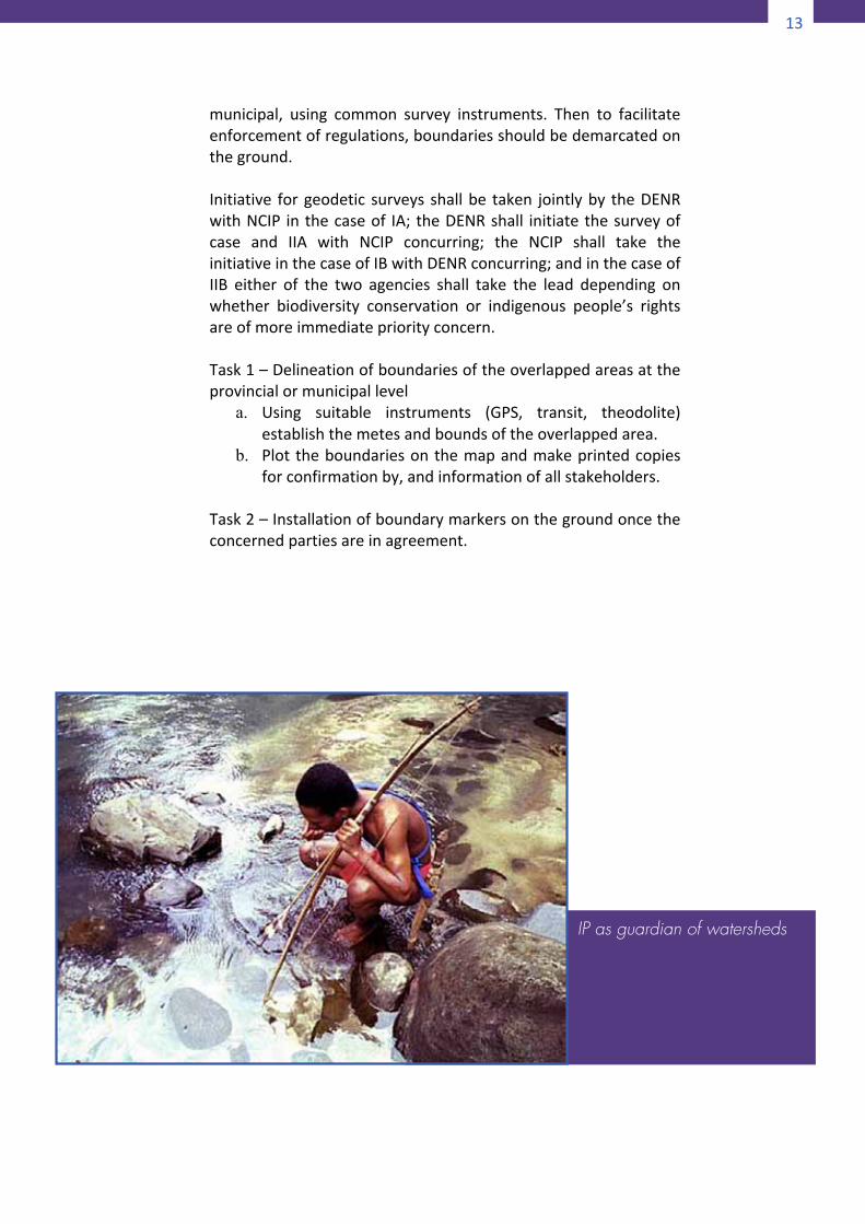
IP as guardian of watersheds
14
14
PartIII
ScenarioAHARMONIZEDMANAGEMENTPLAN
Scenario A pertains to the case of overlapping protectedareas established under the NIPAS with ancestraldomains/landsgrantedCADTundertheIPRA.TheDENRandtheNCIP, conscious of potential and actual policy conflictsand inconsistencies arising from overlapping jurisdictionshave come upwith JointMemorandum Circular (JMC) No.2007-01 expressly formulated to dealwith this scenario. Itclarifies the authority and responsibilities of each agencyconcerned in the planning and management of theoverlapped areas. It specifies the composition and definesthe functions of Technical Working Groups which areresponsible for carrying out all the activities involved inplanningandplanimplementation.
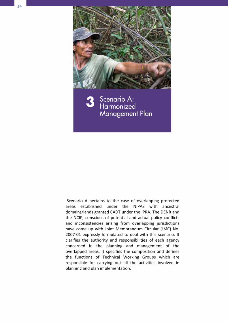
3 Scenario A: Harmonized Management Plan
15
14
PartIII
ScenarioAHARMONIZEDMANAGEMENTPLAN
Scenario A pertains to the case of overlapping protectedareas established under the NIPAS with ancestraldomains/landsgrantedCADTundertheIPRA.TheDENRandtheNCIP, conscious of potential and actual policy conflictsand inconsistencies arising from overlapping jurisdictionshave come upwith JointMemorandum Circular (JMC) No.2007-01 expressly formulated to dealwith this scenario. Itclarifies the authority and responsibilities of each agencyconcerned in the planning and management of theoverlapped areas. It specifies the composition and definesthe functions of Technical Working Groups which areresponsible for carrying out all the activities involved inplanningandplanimplementation.
15
The DENR and the NCIP through their field officesconcerned shall now focus on the areas delineated anddemarcatedasdescribedearlier in thisManualand initiatethe preparation of the harmonized plan following theprocedureprescribedinJMC2007-01.
Step1–OrganizationofPlanningandManagementBodies
TechnicalWorkingGroupsComposition
• ProvincialTechnicalWorkingGroup(PTWG) Co-chairs:PENROandNCIPProvincialOffice Members:PAMBconcernedCommitteechair PPDCand/orMPDC PAMBmember–concernedbarangaysPAMBmember–NGOrepresentatives PAMBmember–POrepresentative ProtectedAreaSuperintendentConcernedNCIPCommunityDevelopmentOfficer/s ProvincialConsultativeBodychair ConcernedNCIPTribalAffairsAssistants NCIPProvincialLegalOfficerAuthorizedICCP/IPelders/leadersfromeach ADoverlappedSecretariat:DENRPAO/CENROstaff NCIPCommunityDevelopmentOfficer
• RegionalTechnicalWorkingGroups(RTWG) Co-chairs:DENRREDandNCIPRD Members:DENRRegionalTechnicalDirectorforPAWCZMS DENRRegionalLegalOfficer RegionalDevelopmentCouncilrepresentatives NCIPRegionalTechnicalManagementServices DivisionChief NCIPRegionalLegalOfficer EthnographicRegionalConsultativeBodyChairSecretariat:DENRProtectedAreasandWildlifeDivisionstaffNCIPRegionalAdministrativeoffice
16
16
FunctionsofTechnicalWorkingGroups• ProvincialTWG
- Reviewofexistingmanagementplans
- Drafttheharmonizedplan- FurnishRTWGcopiesofdraft
harmonizedplan- Assistinresolvingconflicts
• RegionalTWG- Reviewconsistencyofharmonized
planwithexistinglaws,rulesandregulations
- Facilitatetheconsolidation/integrationofplansbytheconcernedPTWGswheretheoverlapareasarelocatedinmorethanoneprovince
- Priortoaffirmation,validateharmonizedplanswiththePAMBandtheIPcommunityconcerned
Step2–ResourceAssessmentandInventoryThetaskofassembling,analyzing,andpreparingdifferenttypesofinformation for use in the planning for andmanaging protectedareas cum ancestral domains will involve various stakeholdersincluding scientists, academics, government functionaries, non-government sectors and advocates, and the local communities.Beinga jointundertakingbetweentheDENRandtheNCIP,bothagenciesshouldpooltheirresourcestogethertobeabletoaccessthebestqualifiedpersonstoprovidetechnicalassistance.Beloware the types of information to be generated and thecorresponding tools and expertise needed to produce them. Ofcourse,thetypeofdatatobegeneratedvariesfromcasetocase.
17
SuggestedInformationInputstotheHarmonizedManagementPlan
(AdaptedfromLockwood,2006)
Thefollowingdatagatheringtechniquesarenotmeanttobeusedineveryplanningcase.Rather,the listservesasamenuoftoolsfromwhichtoselectwhatareapplicabletospecificsites.Geodiversityinventory Abiotic features such as mountains, canyons, lakes,waterfalls and rock formations are spectacular features of thelandscape that draw visitors to a protected area. The structureandprocessesofabioticfeaturesshapetheaesthetic,culturalandbioticelementsofaprotectedarea.Inventoryandassessmentofthe abiotic elements and the overall structure of the landscapeare essential in protected area management. As a minimumrequirement,thelandscapefeaturesshouldbemapped.The recommended tool for data collection and analysis for thisportionisLandscapeEvaluationpreferablyledbyageologistoraLandscape Architect. Participatory land use mapping (SeeAppendices1-Aand1-B) maybeusedtopreparethedraft landusemapbeforeitisputinfinalformbytheexpertsintheteam.BiodiversityinventoryItisvitaltohavein-depthinformationabouttheecosystemsandspecies within a protected area in order to conserve them. Forsome species, there may be extensive amounts of data, andstoringandanalyzingthisdatamaybethegreatestchallenge.Forother species, there may be very little known, and primaryresearch will need to be conducted. Data may include speciescomposition,diversity,distribution,habitatandvulnerability,oritmay be time-series data, tracking the effects of factors such asclimate change. (For suggested technique of faunal survey seeAppendix2.)Abiologistorecologist isneededforthis typeof inventory.Asamatter of expediency, the team within DENR that conducts theProtectedAreaSuitabilityAssessment(PASA)maybecalledintoundertakethebiodiversityassessmentusingtheirowncriteriaorelse, they can also adapt the criteria proposed by Bryn Green.
18
18
(ThePASAandGreenCriteriaare reproduced inAppendices3-Aand3-B).CulturalinventorySince protected areas also overlap areas of cultural values, it isimportant to establish and maintain data on cultural artifacts,sites, beliefs, practices and rituals. Maintaining maps indicatingsites of significance assists in planning activities and developinginfrastructure, and can ensure that these sites are notinappropriatelyintrudedupon.Detaileddescriptionsofthesesitesshould be annotated and maintained. Information can then beprovided to planners and front-line managers to assist withplanningandmanagementandprovidinginterpretationforvisitorgroups.Culturalinformationoftenhasspecialsignificanceforthelocalpopulation,aswellasbeingofinteresttovisitors.Aculturalanthropologistorahistorianwouldbeneededaspartoftheinventoryteamtoconductthemappinganddescriptionofhistorical and cultural relics that may happen to exist in theplanning area. Assistance from the local residents especially themore senior ones is essential. Landusemapping (Appendix 1-B)andhistoricalmapping (Appendix1-G)wouldbetheappropriateassessmenttools.TraditionalKnowledge Traditional knowledge includes inventories of local biologicalresources, such as animal, bird, insect, local plant and treespecies; knowledge about the seasonal cycles of the plants andanimals; the indicatorsof changes in seasons,weatherpatterns,animal and invertebrate behavior, and flowering, fruiting, andseeding. This frequently comprises knowledge that is integral tothesurvivalofalocalcommunityorindigenouspeople,aswellasknowledge that is often useful to scientists and protected areaplanners/managers. Use participatory assessment methods suchas transectwalk, seasonal calendarora combinationof the two(SeeAppendices1-A,1-Cand1-D).This inventory and assessment is best performed by theindigenous and local communities themselves. The scientists intheteamwillassistintheproperdocumentationandtaxonomyoftheexistingspeciesoffloraandfauna.
19
EnvironmentalconditionTheconditionoftheland,includingitsstability,chanceoferosionandlikelihoodofrockfallor landslides issurveyedaspartoftheenvironmentalconditionofasite.Thismaybearesultofnaturalprocesses or generated through human intervention. Threats totheintegrityofanaturalsystem,suchasdegreeofpestandweedinvasion, need to be documented and managed. Fire fuel load,waterquality andquantity,watershed condition, and thehealthof the wildlife population and vegetation are all considerationsrelating to the overall condition of the protected area andpotentially have considerable management implications. Newdevelopmentswithinoradjacenttoprotectedareaswillhaveanenvironmental impact that will need to be assessed. Ongoingmonitoringoftheimpactswillberequired.ThenewtechniquesofStrategicEnvironmentalAssessmentortheolder Environmental Impact Assessment will be useful in thisaspect of the characterization of the planning area. (See alsoAppendix1-F).InfrastructureandphysicalfacilitiesProtected areas often contain a diverse array of structures andequipment. Someof these relate to visitoruse–walking tracks,visitor centers, camping areas, signage and car parks; or formarineareas, jetties,pontoons,markerbuoys,and soon.Otherincidental infrastructure, such as transmission lines and waterstorage,needs tobeconsidered. Infrastructure isoften requiredto support management activities and may include staffaccommodation, power supply, transport systems andtelecommunications facilities. In terrestrial areas there isusuallyan access network of roads and tracks. Some reserves containresident populations or visitor accommodation thatwill need tobedocumented.Theservicesofacivilengineerintheteamwillbeindispensableinthisregard.Usesbyindigenouspeoples,localcommunitiesandothersDependingupontheircategory,protectedareascanbesubjecttoa range of domestic consumption, livelihood and commercialuses. Examples include scientific research, access to genetic
20
20
resources,honeyproduction,fishing,wateruseandharvestingofnon-timber forest products (NTFPs) such as rattan, resins, orbeeswax. Information is needed to ensure the effective andappropriatemanagementofsuchuses.This can be done by the local communities themselves usingparticipatory techniques like transect walk (Appendix 1-A) andseasonalcalendar(Appendix1-C).VisitoruseManyprotectedareasarevaluabletouristattractionsandvisitormonitoringprogramsneedtobeimplemented.It is importanttomonitor the level of visitor use in protected areas. Visitationfigures are necessary to estimate environmental impacts andcarrying capacity, to make decisions about infrastructureinvestments, to calculate the regionaleconomicbenefitofparksand to monitor visitor satisfaction. The impacts of visitors atsensitivesitesshouldalsobemeasuredandmonitored.This task can be done by the local tourism office of the localgovernmenthavingjurisdictionovertheplanningarea.CommunitypopulationinventoryUnderstanding the local community and its economic, cultural,demographic,employmentandsocialstructureiscrucial.Muchofthedatamaybeavailablefromgovernment(national,regionalorlocal)statistics.Someinformationcanonlybeobtainedbywrittensurveys, interviews, focusgroups,etc. (Appendices4-Aand4-B).Human uses – such as business and residential development,hunting, fishing, cuttingwood, clearingareas for agricultureandrecreation – need to be considered. In the case of communityconserved areas (CCAs) and other protected areas in whichindigenous and local communities reside, the community’s ownunderstanding of history, biodiversity conservation andsustainableresourceutilizationiscritical.ThistaskcanbeappropriatelyperformedbythestaffofthelocalplanninganddevelopmentofficeoftheLGUconcerned.Thedatagenerated should formpart of the LGU’s socio-economic profileorecologicalprofileasthecasemaybe.
21
Socialandland-usehistoryBeing informedabout thehumanor socialhistoryof thearea isinvaluable toprotectedareaplanners/managers. In combinationwith the environmental history and the current situation, thisinformationcanprovideacompletepictureofwhathasoccurredin the area. For example, the variety of land uses may help toexplainthecompositionofthelandscape.Likeculturalresources,socialhistory canbeused toprovide interpretations for visitors.This,too,canformpartoftheLGU’secologicalprofile,withinputsfromthelocalofficeoftourismpromotion.ParticipatoryhistoricalmappingrelevanttothissectionisdescribedinAppendix1-G.Step3–AnalysisofDataStep3.1IdentifyissuesandconflictsConflicts as categorized by Lockwood (2006) could take theformofincongruencebetween:
a. consumptiveusesandconservationvalues,e.g.animalgrazingvs.conservationofrarespeciesofflora;
b. one resource component and another, e.g.introduction of exotic species vs. propagating nativespecies;
c. intensity of use and the carrying capacity of theresource being used, e.g. heightened bush campingexperience and the resulting problems of vegetationdepletion, rubbish and toilet waste disposal, and thelike;and
d. one typeofuseandanotherof thesameresourceorarea,e.g.smallfisherfolkvs.watersportrecreationists,forest-dwellersvs.wildlife tourists,mountain trekkerstraversing“no-go”areas suchas sacredgroves,burialgroundsandotherritualareasofICCs/IPs.
The assessment methods used were not only for resourceinventory purposes but also for identifying issues andchallenges. Through map overlay, for example, possiblezonationissuesmayarisesuchaswhenthedesignatedStrictProtectionZones(SPZ)underNIPASdonotincludetheareascustomarily regarded by IPs as “ no-go” zones like burialgrounds, sacred groves, hunting areas, etc. The transectwalk, for another example, might yield information aboutspecific resources or species to be an important source of
22
22
foodorlivelihoodfortheIPsbutwhicharealsomarkedoutas threatened or endangered by the DENR. Conversely,PAMB policies might allow year round resource extractionactivities within the Multiple Use Zone (MUZ) but theseasonalcalendaroftheIPsmightindicatethelatter’sstrictobservanceof“closedseasons”or“fallowperiods”.Another set of issues pertain to threats to the integrity ofthe resources that are sought to be protected. Direct andindirectthreatsmaycomefromnaturalphenomenasuchasfloods, wildfires, landslides, etc. or from human andinstitutionalactivities.When theprotectedareaorportionsof it are opened for extractive or recreational activities,planners/managers are advised to understand thevulnerabilitiesofthearearesourcestobetteranticipatetheimpactsofthoseactivities.(SeeAppendices5and6.)Yet another set of issuesmay take the formof backlogs orshortfallsintheprovisionofpublicgoodsandsocialservicesforthepromotionofwell-beingofthecommunitieslivinginthe protected area, both indigenous and migrant.Information on these aspects is normally derived from therelevantportionsof the LGU’s socio-economicor ecologicalprofile. Otherwise, the community-based and focus groupinterviewswillhaveelicitedsuchtypesof information.Also,the assessment of infrastructure and physical facilities willprovide information on the current state and quality ofexisting services on the site. Backlogs in social services likeeducation, health, welfare, etc. are determined by simplycomparing the state of existing services and facilities withprevailingnationalstandardsorregionalbenchmarks.
Tofacilitateanalysis,thefollowingframeworkmaybeused:
23
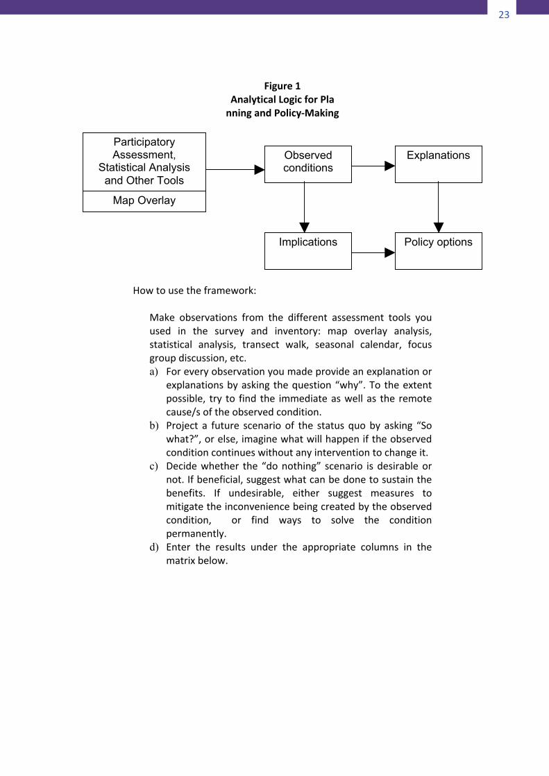
Figure1
AnalyticalLogicforPlanningandPolicy-Making
Howtousetheframework:
Make observations from the different assessment tools youused in the survey and inventory: map overlay analysis,statistical analysis, transect walk, seasonal calendar, focusgroupdiscussion,etc.a) Foreveryobservationyoumadeprovideanexplanationor
explanationsbyaskingthequestion“why”.Totheextentpossible, try to find the immediateaswellas the remotecause/softheobservedcondition.
b) Project a future scenarioof the statusquoby asking “Sowhat?”,orelse,imaginewhatwillhappeniftheobservedconditioncontinueswithoutanyinterventiontochangeit.
c) Decidewhether the “donothing” scenario isdesirableornot.Ifbeneficial,suggestwhatcanbedonetosustainthebenefits. If undesirable, either suggest measures tomitigatetheinconveniencebeingcreatedbytheobservedcondition, or find ways to solve the conditionpermanently.
d) Enter the results under the appropriate columns in thematrixbelow.
Participatory Assessment,
Statistical Analysis and Other Tools
Map Overlay
Observed conditions
Implications
Explanations
Policy options
24
24
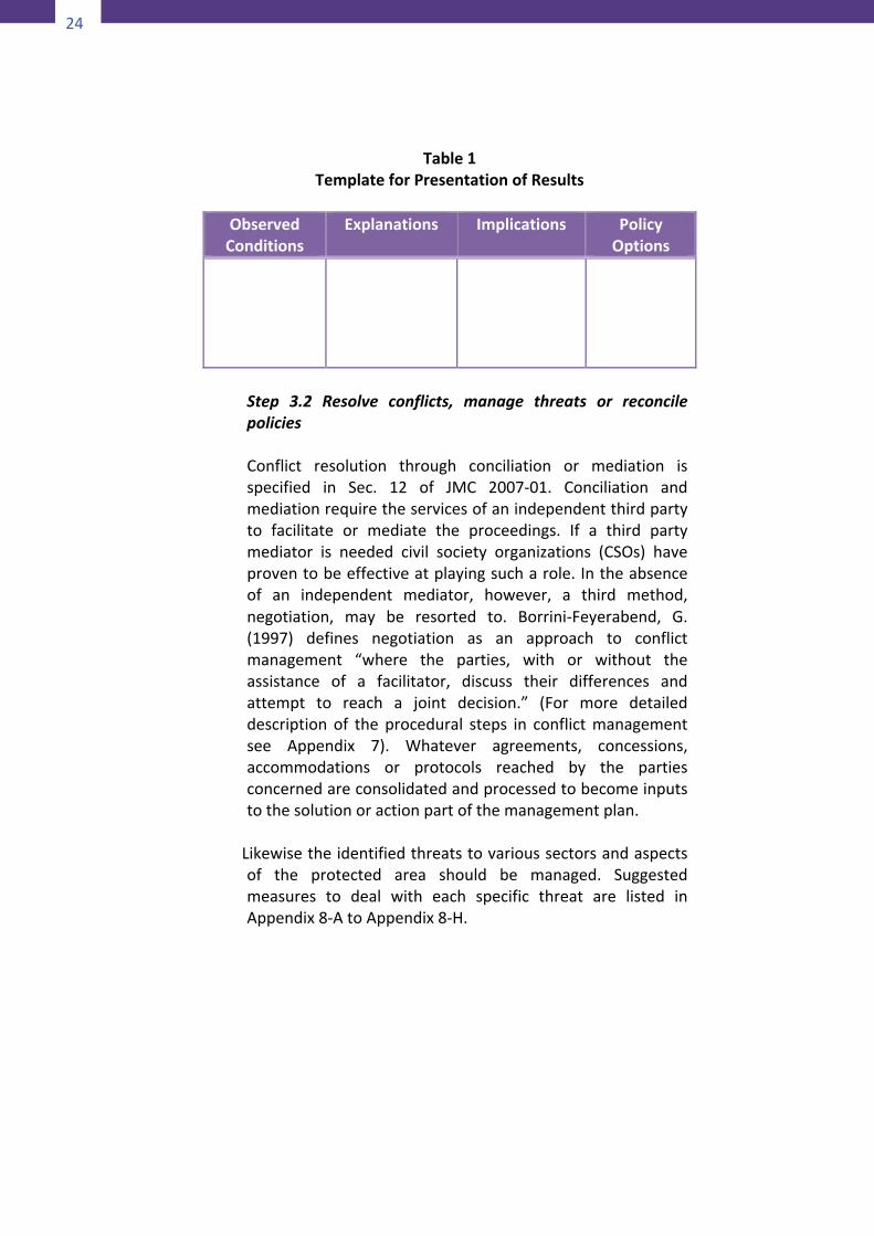
Table1TemplateforPresentationofResults
ObservedConditions
Explanations Implications PolicyOptions
Step 3.2 Resolve conflicts, manage threats or reconcilepoliciesConflict resolution through conciliation or mediation isspecified in Sec. 12 of JMC 2007-01. Conciliation andmediationrequiretheservicesofanindependentthirdpartyto facilitate or mediate the proceedings. If a third partymediator is needed civil society organizations (CSOs) haveproventobeeffectiveatplayingsucharole.Intheabsenceof an independent mediator, however, a third method,negotiation, may be resorted to. Borrini-Feyerabend, G.(1997) defines negotiation as an approach to conflictmanagement “where the parties, with or without theassistance of a facilitator, discuss their differences andattempt to reach a joint decision.” (For more detaileddescription of the procedural steps in conflictmanagementsee Appendix 7). Whatever agreements, concessions,accommodations or protocols reached by the partiesconcernedareconsolidatedandprocessedtobecomeinputstothesolutionoractionpartofthemanagementplan.
Likewisetheidentifiedthreatstovarioussectorsandaspects
of the protected area should be managed. Suggestedmeasures to deal with each specific threat are listed inAppendix8-AtoAppendix8-H.
25
24
Table1TemplateforPresentationofResults
ObservedConditions
Explanations Implications PolicyOptions
Step 3.2 Resolve conflicts, manage threats or reconcilepoliciesConflict resolution through conciliation or mediation isspecified in Sec. 12 of JMC 2007-01. Conciliation andmediationrequiretheservicesofanindependentthirdpartyto facilitate or mediate the proceedings. If a third partymediator is needed civil society organizations (CSOs) haveproventobeeffectiveatplayingsucharole.Intheabsenceof an independent mediator, however, a third method,negotiation, may be resorted to. Borrini-Feyerabend, G.(1997) defines negotiation as an approach to conflictmanagement “where the parties, with or without theassistance of a facilitator, discuss their differences andattempt to reach a joint decision.” (For more detaileddescription of the procedural steps in conflictmanagementsee Appendix 7). Whatever agreements, concessions,accommodations or protocols reached by the partiesconcernedareconsolidatedandprocessedtobecomeinputstothesolutionoractionpartofthemanagementplan.
Likewisetheidentifiedthreatstovarioussectorsandaspects
of the protected area should be managed. Suggestedmeasures to deal with each specific threat are listed inAppendix8-AtoAppendix8-H.
25
Step4–ManagementPlanningfortheOverlappedAreas
Step4.1EstablishgoalsandobjectivesGoal formulation is always the first part of any rationalplanning process. A goal is a general statement of ends.Sometimes the termvision isusedbut there isnoessentialdifferencebetweenagoalandavision.Agoaloravision isnot necessarily achievable in the planning period, butindicatesthegeneraldirectiontowhichallproposedactionsinthemanagementplanaspire.Forexample,theoverallgoalofaharmonizedmanagementplantopromotethesocialandeconomic well-being of indigenous communities and at thesametimemaintaintheintegrityofthenaturalenvironmentmaytakealongtimetorealize,ifatall.Butavisionoragoalisimportantnonethelessbecauseitcanraiseaspirationsandmotivate effort. Goals motivate people to take actionstowardswhattheybelievewillyieldtheimaginedresult.Moreover,becauseoftheirverygeneralnature,goalsarebythemselves insufficient for directing management. In orderforgoalstobeabletoguidespecificactionstheyhavetobereduced into objectives. An objective is a statement ofrealistic,measurableandspecificendstobeachievedwithinaspecificperiodoftime.Objectivesarerequiredforeffectiveevaluationofaplansinceifitisunclearwhataplanintendsto achieve, it is not possible to determine its success orfailure.Withoutobjectives,amanagercannotknowwhenaparticular action achieved the desired result (and thereforemoveontoachievingotherobjectives).Norcanthemanagerdiscover if a particular action is, in fact, not achieving thedesired result, andwhether another action should be triedinstead. Ideally, an objective should be: 1) specific, 2)measurable,3)attainable,4)realistic,and5)timelimited,orin short, S-M-A-R-T. Below are examples of specificobjectivesthatmightbetargetedwithinaspecifiedperiodoftimesay,onecalendaryear.
• conservenativeplantsandanimals;• secureaculturallyimportantsite;• protectasiteofcriticallivelihoodimportance;• providearangeofrecreationopportunities;and• controlplantandanimalpests.
26
26
Asimpleguidetoformulatingobjectivesistotakeanyissueor problem identified during the data analysis step of thisplanningprocess.Thennegatetheissueorproblem,applyingthe intuitive formula:a goal or objective is the inverse of aproblem.Forexample, if it isfoundthatthepopulationofacertain wild pig is getting precariously small and that it isfurther found that hunting is being carried out on a year-roundbasis,anobjectiveofthemanagementplanmightbeto impose amoratoriumor closed season on hunting for aspecifiedperiod.Step 4.2 Develop policy options (strategies) for achievingobjectivesFormulating a goal or objective by the simple expedient ofnegating an identified problem or issue may be veryconvenient but it may not yield all the possible solutions,muchlessthemostpreferredone,totheproblem.Alongerprocess which promises to yield better results is to digdeeper into the cause/s and implication/s of the identifiedproblem. The process is called extracting intelligence oraskingtheprobequestions“why”and“sowhat”.Findingtheanswer to thequestion “why” leadsone todigup thepastand try to understand the historical antecedents that willhelpexplainwhy theobserved condition is suchas it is. Toanswer the question “so what”, on the other hand, forcesoneto look intothefuture, imaginingscenariosaboutwhatwill happen if the observed condition continues unresolved(Review Fig. A-1). Then based on the answers to theseintelligence questions generate policy options or strategies.(ReferbacktoStep4.1).A policy is a solution statement of the “if-then” variety. Apolicyisuseful inthatitautomatesrepeatdecisionstosavetime or to ensure that the same action is taken under thesame circumstances, giving a sense of fairness andpredictability. Example: If IPs observe a fallow period longenough to allow resource regeneration then they cancontinue to practice swidden agriculture. A strategy, incontrast, is a cluster of solution statements targeted tovarious aspects or causes of a problem. For example, toreturn to the issue ofwild pig population getting depleted,perhaps hunting is just one of the causes and regulatinghuntingmaynotentirelysolvetheproblem.Onecausemay
27
be that the forage area of the animals is severely reduceddue to human settlement encroachment into the forests.Anothercausemaybetracedtotheincreasingpopularityofwildanimalmeatasnoveltyorexoticfoodsbeingservedbytourist related establishments. If the goal is to restore thepopulationofwildpigstosustainable levelsagoodstrategyistotargetalltheknowncausesoftheanimal’sdiminishingnumber.Ausefulwayofgettingalloftheseideasdownonpaperistoholda‘brainstorming’session.Step4.3ProcessandclassifytheproposedactionsThe output of Steps 4.1 and 4.2 will make a long list ofpolicies, strategies and actions. When collected togetherthesesuggestedactivitiesbecomeanagenda:a listofwhatto do. When translated into an agenda, a plan becomes atool for management. Before this to-do list can be useddirectly formanagementpurposes theactivitiesneed tobeclassified into projects, non-projects or services, andregulatorymeasures.Processingproposedactionsentailsthefollowingsub-steps:
• Siftprojectsfromnon-projects• Classify projects by administrative ownership or
responsibility• Process non-projects for possible upgrading into
projects,orelse, farmoutactivitiestoresponsiblebodiesandagencies
a) Siftingprojectsfromnon-projects
This sub-step is very important in that it gives a clue todeterminingpossiblesourcesoffundstoimplementprojects.If funding is to be sought from the local government, forexample, funding for projects will be taken from the LocalDevelopmentFundwhilefundingfornon-projectswillcomefrom the maintenance and other operating expenditures(MOOE)ofparticulardepartmentsoroffices responsible fordelivering the service required. In the case of non-projects,identifywhatoffice,agencyororganizationisresponsiblefordelivering the needed services, or what level of legislativebody possesses the power to enact a needed law orordinance,orwhatexecutivebodyhastheauthoritytoissue
28
28
an order, rule or regulation required. Use the template inTable A-2 below as a guide for classification and enter theresultintheformatasshowninTableA-3.
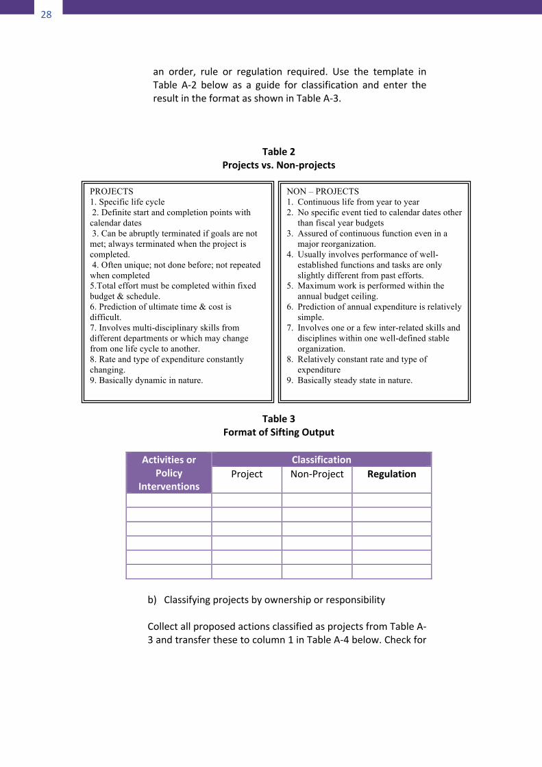
Table2Projectsvs.Non-projects
Table3FormatofSiftingOutput
Activitiesor
PolicyInterventions
ClassificationProject Non-Project Regulation
b) ClassifyingprojectsbyownershiporresponsibilityCollectallproposedactionsclassifiedasprojectsfromTableA-3andtransferthesetocolumn1inTableA-4below.Checkfor
PROJECTS 1. Specific life cycle 2. Definite start and completion points with calendar dates 3. Can be abruptly terminated if goals are not met; always terminated when the project is completed. 4. Often unique; not done before; not repeated when completed 5.Total effort must be completed within fixed budget & schedule. 6. Prediction of ultimate time & cost is difficult. 7. Involves multi-disciplinary skills from different departments or which may change from one life cycle to another. 8. Rate and type of expenditure constantly changing. 9. Basically dynamic in nature.
NON – PROJECTS 1. Continuous life from year to year 2. No specific event tied to calendar dates other
than fiscal year budgets 3. Assured of continuous function even in a
major reorganization. 4. Usually involves performance of well-
established functions and tasks are only slightly different from past efforts.
5. Maximum work is performed within the annual budget ceiling.
6. Prediction of annual expenditure is relatively simple.
7. Involves one or a few inter-related skills and disciplines within one well-defined stable organization.
8. Relatively constant rate and type of expenditure
9. Basically steady state in nature.
29
28
an order, rule or regulation required. Use the template inTable A-2 below as a guide for classification and enter theresultintheformatasshowninTableA-3.
Table2Projectsvs.Non-projects
Table3FormatofSiftingOutput
Activitiesor
PolicyInterventions
ClassificationProject Non-Project Regulation
b) ClassifyingprojectsbyownershiporresponsibilityCollectallproposedactionsclassifiedasprojectsfromTableA-3andtransferthesetocolumn1inTableA-4below.Checkfor
PROJECTS 1. Specific life cycle 2. Definite start and completion points with calendar dates 3. Can be abruptly terminated if goals are not met; always terminated when the project is completed. 4. Often unique; not done before; not repeated when completed 5.Total effort must be completed within fixed budget & schedule. 6. Prediction of ultimate time & cost is difficult. 7. Involves multi-disciplinary skills from different departments or which may change from one life cycle to another. 8. Rate and type of expenditure constantly changing. 9. Basically dynamic in nature.
NON – PROJECTS 1. Continuous life from year to year 2. No specific event tied to calendar dates other
than fiscal year budgets 3. Assured of continuous function even in a
major reorganization. 4. Usually involves performance of well-
established functions and tasks are only slightly different from past efforts.
5. Maximum work is performed within the annual budget ceiling.
6. Prediction of annual expenditure is relatively simple.
7. Involves one or a few inter-related skills and disciplines within one well-defined stable organization.
8. Relatively constant rate and type of expenditure
9. Basically steady state in nature.
29
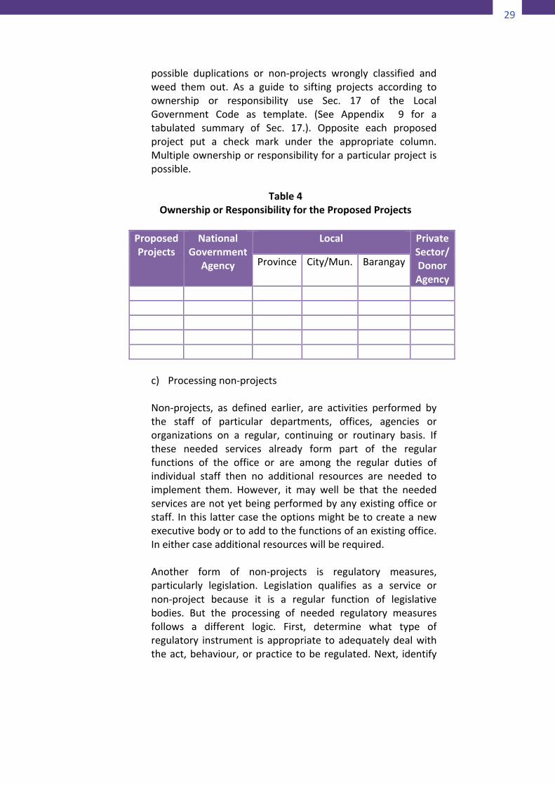
possible duplications or non-projects wrongly classified andweed them out. As a guide to sifting projects according toownership or responsibility use Sec. 17 of the LocalGovernment Code as template. (See Appendix 9 for atabulated summary of Sec. 17.). Opposite each proposedproject put a check mark under the appropriate column.Multipleownershiporresponsibilityforaparticularprojectispossible.
Table4
OwnershiporResponsibilityfortheProposedProjects
ProposedProjects
NationalGovernment
Agency
Local PrivateSector/DonorAgency
Province City/Mun. Barangay
c) Processingnon-projectsNon-projects, as defined earlier, are activities performed bythe staff of particular departments, offices, agencies ororganizations on a regular, continuing or routinary basis. Ifthese needed services already form part of the regularfunctions of the office or are among the regular duties ofindividual staff then no additional resources are needed toimplement them. However, it may well be that the neededservicesarenotyetbeingperformedbyanyexistingofficeorstaff. Inthis lattercasetheoptionsmightbetocreateanewexecutivebodyortoaddtothefunctionsofanexistingoffice.Ineithercaseadditionalresourceswillberequired.Another form of non-projects is regulatory measures,particularly legislation. Legislation qualifies as a service ornon-project because it is a regular function of legislativebodies. But the processing of needed regulatory measuresfollows a different logic. First, determine what type ofregulatory instrument is appropriate toadequatelydealwiththeact,behaviour,orpracticetoberegulated.Next, identify
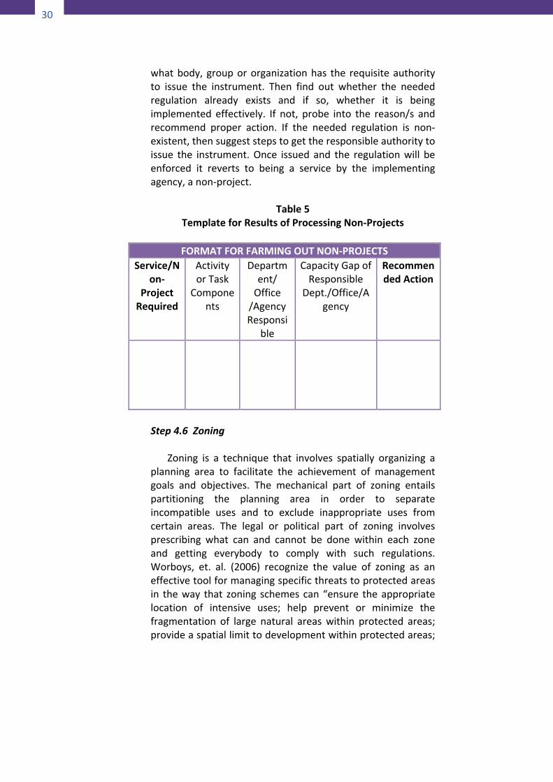
30
30
whatbody, groupororganizationhas the requisiteauthorityto issue the instrument. Then find out whether the neededregulation already exists and if so, whether it is beingimplemented effectively. If not, probe into the reason/s andrecommend proper action. If the needed regulation is non-existent,thensuggeststepstogettheresponsibleauthoritytoissue the instrument.Once issued and the regulationwill beenforced it reverts to being a service by the implementingagency,anon-project.
Table5TemplateforResultsofProcessingNon-Projects
FORMATFORFARMINGOUTNON-PROJECTS
Service/Non-
ProjectRequired
ActivityorTask
Components
Department/
Office/AgencyResponsi
ble
CapacityGapofResponsible
Dept./Office/Agency
RecommendedAction
Step4.6Zoning Zoning is a technique that involves spatially organizing aplanning area to facilitate the achievement of managementgoals and objectives. The mechanical part of zoning entailspartitioning the planning area in order to separateincompatible uses and to exclude inappropriate uses fromcertain areas. The legal or political part of zoning involvesprescribing what can and cannot be done within each zoneand getting everybody to comply with such regulations.Worboys, et. al. (2006) recognize the value of zoning as aneffectivetoolformanagingspecificthreatstoprotectedareasin theway that zoning schemescan“ensure theappropriatelocation of intensive uses; help prevent or minimize thefragmentation of large natural areaswithin protected areas;provideaspatiallimittodevelopmentwithinprotectedareas;
31
andhelptoprovideadditionalprotectivemeasuresforselectareas.”Howshouldwezonetheharmonizedmanagementarea?Let’s start with the NIPAS management zoning scheme.Originally, under DENR AO No. 25, s. 1992, there were ninepossible zones thatcouldbedelineatedwithin theprotectedarea and its buffer. But these nine zones could be furtherclassified according to whether or not to allow entry byhumans and, where entry is allowed, what human activitiescan also be allowed and at what intensity. Subsequently,DENR amended DAO 25 reducing the number of NIPASmanagement zones to only two: Strict Protection Zone andMultipleUseZone.UnderDENRDAONo.28,s.2008thetwozonesaredefinedthus:
1) Strict Protection Zone (SPZ) shall comprisenatural areas
withhighbiodiversityvalue,closedtoallhumanactivitiesexcept for scientific studies and/or ceremonial orreligious use by the ICCs/IPs. Itmay include habitats ofthreatened species, or degraded areas that have beendesignated for restoration and subsequent protection,even if these areas are still in various stages ofregeneration.
2) MultipleUseZone(MUZ)shallcompriseareaswherethe
followingmaybeallowed consistentwith theprotectedarea management plan: settlement, traditional and/orsustainableland-use, includingagriculture,agro-forestry,and other income generating or livelihood activities. Itshall also include, among others, areas of highrecreational tourism, educational or environmentalawareness values and areas consisting of existinginstallations of national significance/interest such asdevelopment of renewable energy sources,telecommunicationfacilitiesandelectricpowerlines.
The new zonation scheme is simplified alright but forpurposesofzoningtheharmonizedareaafewmodificationsneedtobeintroduced.First, the SPZ should be expanded to include those areas,artifacts andnatural resources customarily regardedby the
32
32
specifictribalgroupas“notouch,nogo”areassuchastheirburial grounds, sacred groves, hunting areas, traditionalsourcesoflivelihood,andthelike.Secondly, for their effective protection, the no-go areasshouldhavetheirownbuffersofsomekind,apart fromthebufferfortheentireNIPASprotectedarea.Thirdly,therehastobeawaytodistinguishsub-categoriesof“multipleuse”activitiessuchasthoseassociatedwith livingor domestic household activities from activities devoted toproduction or livelihood. Activities of indigenouscommunitieswhicharerecognizedunderJointAONo.2008-01assustainableindigenouspracticesareagoodexampleoftheproduction-typeofmultipleuse.Finally,theinfrastructuresupportforbothproductionaswellasdomesticactivitiesshouldbeadistinctcomponentoftheMUZ.Thisultimatelyalignsourzoningwiththefourlandandwaterusepolicyareasofthenationalandlocalgovernmentsnamely, protection, production, settlements andinfrastructure areas thereby facilitating the process ofmainstreaming into the plans of the local governmentconcerned.
Step5–ImplementtheplanImplementation of the harmonized management plan involvesperforming the three management activities namely,enforcement of regulations, implementation of projects, anddelivering continuing and routine services. Regulations are thebodyof rules andpolicies formulated toprotect the integrity ofthe environment and natural resources within the area ofmanagement. Projects are capital expenditures designed tomaintain or improve the quality of infrastructure within theprotectedareaanditsbufferzone.Servicesincludehousekeepingchoresperformedbythemanagementstaffaswellasassistanceextended to the resident communities, both indigenous andmigrant, so as to safeguard their well-being and promote theirgeneralwelfare.Who is responsible for performing the above activities and howwilltheseactivitiesbefunded?
33
On the question of responsibility, JMC 2007-01, Section 10,explicitly assigned the ICCs/IPs concerned the “primaryresponsibility to maintain, develop, protect and conserve suchoverlapped areas with the assistance from the DENR and otherconcernedgovernmentagencies”.Itishighlyprobablethatatthistime indigenous communities are not ready to take on theresponsibility ofmanaging a protected area. For this reason theJMChas given the ICCs/IPs concerned theoption to temporarilytransfer in writing the responsibility to other agencies(presumably the DENR) until such time that they will haveacquiredthepropermanagementtechnologyandknowhow.One excellent training ground for the IPs to learn the ropes inprotected area management is the Protected AreaSuperintendent(PASu),abodycreatedtoruneach individualPAsiteonaday-to-daybasis.TheProtectedAreaManagementBoard(PAMB)ofeachNIPASprotectedarea thatoverlapsanancestraldomain should make it a policy to deputize as many IPs as arequalified in thearea to serveas fieldofficers.Thedeputationof“tribalcommunities”asfieldofficersisauthorizedunderDENRAONo.96-28datedSeptember19,1996.Fieldofficersareauthorizedunder theAO “to investigate and searchpremises andbuildingsandeffectarrestfortheviolationoflawsandregulationsrelatingprotectedareas”.Thelearninghereishoweverlimitedtothatofenforcementofregulatorymeasures.Regarding the capacity to plan and manage projects, the IPsshouldlearnasmuchastheycanfromtheir interfacewithotheragencies and organizations that have projects to implementwithin the ancestral domain. They should seek to participate inevery phase of the project management cycle. As regards theextension of social services to the residents of the overlappedarea, the ICCs/IPs must invoke the responsibility of the localgovernments concerned to promote the general welfare of alltheir inhabitants (Sec. 16,RA7160). Tobe able to get the LGUsconcernedtoacknowledgetheirresponsibilitytheICCs/IPsshouldlearn how to mainstream their plans into the local governmentplaneffectively.Onthequestionoffunding,theJMCrequiresbothDENRandNCIPto jointly make funds available for the management of theoverlappedareas.
34
34
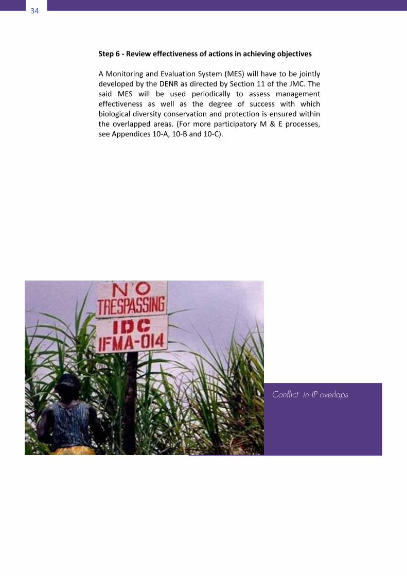
Step6-RevieweffectivenessofactionsinachievingobjectivesAMonitoringandEvaluationSystem(MES)willhavetobejointlydevelopedbytheDENRasdirectedbySection11oftheJMC.Thesaid MES will be used periodically to assess managementeffectiveness as well as the degree of success with whichbiologicaldiversityconservationandprotectionisensuredwithinthe overlapped areas. (Formore participatoryM& E processes,seeAppendices10-A,10-Band10-C).
Conflict in IP overlaps
35
34
Step6-RevieweffectivenessofactionsinachievingobjectivesAMonitoringandEvaluationSystem(MES)willhavetobejointlydevelopedbytheDENRasdirectedbySection11oftheJMC.Thesaid MES will be used periodically to assess managementeffectiveness as well as the degree of success with whichbiologicaldiversityconservationandprotectionisensuredwithinthe overlapped areas. (Formore participatoryM& E processes,seeAppendices10-A,10-Band10-C).
Conflict in IP overlaps
35
PartIII
ScenarioB
MAKINGTHEPROTECTEDAREAMANAGEMENTPLANSENSITIVETOINDIGENOUSPEOPLE’S
RIGHTSANDREQUIREMENTS
ThismanagementplanningapproachpertainstothecaseofaNIPAS protected area that overlaps a non-CADT indigenouscommunity. Because the protected area is placed under theNIPAS, it can be presumed that there already exists aProtected Area Management Plan as required by law. Thequestion of whether or not to prepare an ADSDPP for theoverlappedareadependsonwhattenurestatustheICCs/IPsopttoassume.1.OptiontoClaimAreaasAncestralDomain
3 Scenario B: Making the Protected Areas Man-agement Plan Sensitive to Indigenous People’s Rights and Requirements
36
36
TheNIPASlawhasalwaystakenadeferentialattitudetowardstheICCs/IPsoccupyingportionsofNIPASprotectedareas.Bybeing careful not to displace or relocate them, by beingrespectful of their rights, and by treating them differentlyfromnon-tribaltenuredmigrants,thelawhaslefttheICCs/IPswiththeoptionofeventuallyclaimingtheplacestheyoccupyas their ancestral domain. Moreover, the IPRA providesprotection to those tribeswho voluntarilymigrated to otherplacesorthosewhoweredisplacedbynaturalandman-madecalamitiesandwereresettledinotherregions.UnderRuleIII,Part II, Sec. 4 (c) of the IRR of IPRA, ICCs/IPs who wererelocated permanently, shall upon their free prior informedconsent,beaccordedthefollowingrights:(1) Relocationtoasite,whichshall,inallpossiblecases,beof
equalqualityandlegalstatusasthatwhichtheypreviouslyoccupied,andwhichshallbesuitable toprovide for theirpresentneedsandfuturedevelopment;
(2) Security of tenure over lands to which they will beresettledorrelocated;and
(3) Compensationforloss,injuryordamageasaconsequenceofsuchrelocationordisplacement.
Intheeventthatthe indigenouscommunitieswithinaNIPASprotected area opt to claim their area as their ancestraldomain and apply for a CADT, the change in their statusreverts to that of Scenario A and the management planappropriatefortheoverlappedareaistheharmonizedplan.2.OptiontoRemainaNon-CADTIndigenousCommunityIfforwhateverreasontheICCs/IPscouldnotbegrantedCADTon the areas they occupy what tenure instrument can theyavail of should they desire continued stay in the protectedarea? For sure, they cannot apply for the grant of mereresourceuse instruments (RUI) for thatwouldmake themofthe same category as non-tribal tenured migrants. Asobserved earlier the law takes a deferential stance towardsindigenouspeople.
2.1Co-managementarrangementOne possibility is for the ICCs/IPs to enter into a co-management arrangement. The reason for this is that
37
although theymayalreadybe represented in thePAMBmembership, the indigenous communities are notmerestakeholdersbutarerights-holdersaswellonaccountoftheirhistoricalandculturalassociationwiththeterritoryandoftheirdirectdependenceonthelocalenvironmentfor their livelihood. Under a co-managementarrangement,theICC/IPwilltransformfromtheirpresentstatus as co-managers being members of a singlemanagement body (PAMB) to that of governancepartners. But are the ICCs/IPs ready for this change ofstatusandrelationship?According to Kothari (in Lockwood, et. al., 2006) thecontribution of local communities (IPs included) inprotectedareamanagementvaries. In somecases, theyareinvitedonlyforconsultationorsomeformofbenefitsharing. Inothers,theyare includedinthemanagementorganizationandgiventhepowerofinfluencingdecisionsasaminorityvoice.Instillothercases,theyareincludedinanorganizationwithtechnicaland/ordecisionmakingcapacity that requiresdeliberationby consensus. ItmaybeobservedthatthePAMBinrespectofNIPASprotectedareas isdesignedto functionas in the thirdcaseabove.SohowarethePAMBsfaringsofar?InanIUCN-commissionedregionalreviewofco-managedprotected areas (CMPA), the following is said about thePhilippines:“An example of relatively weak CMPAs is thePhilippineswhereeachprotectedareaisexpectedbylawto be run by a management board composed ofgovernment officers, NGOs and communityrepresentatives. Unfortunately, this has not yet beenfunctioning effectively due to various limitations – fromlack of documents in local languages and resources formeetingsandworkshops,tothefactthatthelocalpeoplearetooshytovoicetheirconcernsinthepresenceoftheboardchairperson,who isagovernmentofficer.For thetime being, the decision-making power still remainsfirmly in the government’s hands.” (Quoted in Kothari,2006)
38
38
It seems that the prospect for adopting the co-managementarrangementofthepartnershiptypeisnotbright in the short term but it is worth keeping thisoption for the medium or long term. And, while themanagementof theprotectedareawill stillbeassumedby the PAMB, measures will be introduced towardsencouraging more substantial participation by theindigenous communities to enable them to eventuallygain the confidence to deal with other stakeholders onequalfooting.Inthemeantime,whathastobedoneistomake the existing PAMP responsive to the needs andsensibilitiesoftheICCs/IPsresidingintheprotectedarea.2.2 Toward an IP-sensitive ProtectedAreaManagementPlanTherecurrentlyarenopoliciesdirectedatcaseslikethis.The existing directive that is close to being applicablehere is JointDENR-NCIPAdministrativeOrderNo. 2008-01 provided certain slight modifications could beintroduced. Forexample,whereas the JointAOpertainsto the formal recognition of IPs’ sustainable productionandlivelihoodpracticesascompatiblewiththeobjectivesof biodiversity conservation within their own ancestraldomains, the same principles and procedures ofrecognition couldbeextended to IP communities insideNIPASprotectedareas.
2.2.1PolicyfoundationThe ideaof formulatingaPAMPthat is sensitive totheneedsandsensibilitiesof ICCs/IPsfindssupportinthepolicyoftheStateto“protectandguaranteetheir[ICCs/IPs]righttopursuetheireconomic,socialandculturalwell-beingnotonlytoensureequitablesharingofbenefitsfromthebountyoftheearthbutalsotoenablethemtoflourishunderabalancedandhealthful ecology, in accord with the rhythm andharmonyofnature”(Sec.1,JAO2008-01).This means that the IPs occupying protected areasare treatedasvirtualpartners inconservationbothin terms of their cultural practice of keeping“sacred”sitesas“notouch,noentry”areasaswell
39
as through their customary resource use systemswhichareproven tobesustainableanddoactuallycontributetoconservationobjectives.2.2.2 Modifiedharmonizationprocess
FormulatingtheIP-sensitizedPAMPisavariationonthe generic harmonization process as described inthe preceding section (Scenario A). Necessarilymodifications will be introduced. For example,unlike in Scenario A where the area of overlap isbetween a NIPAS protected area and an ancestraldomain with CADT, under Scenario B, the areaoccupied by the IP community is not an ancestraldomain.Therefore, inthelattercase, itmaynotbenecessary to delineate the outer boundary of the“overlapped”area.Whatneedtobedelineatedarethe spatial units of analysis, the ancestral domainmanagement blocks/units as provided for in JAO2008-01. Ancestral domain managementblocks/units are defined in JAO 2008-01 as“indigenous communities/areas or parts thereofwhich have the same natural, socio-economic andpolitical conditions that arebeing governedbyonetraditionalleadershipsystemandpracticingasingletype of traditional and indigenous forest resourcesmanagement.” Each management unit ischaracterized by a common set of sustainabletraditional and indigenous forest resourcesmanagement systems and practices (STIFRMSP)which the particular IP community registers forformal recognition as a form of sustainable forestmanagement system. The recognition is formalizedand confirmed through a memorandum ofagreement(MOA)executedbythekeystakeholdersincluding the DENR, NCIP, ICCs/IPs and theirelders/leadersandtheLGUsconcerned.
Themostimportantoutputofthisharmonization
procedure is the revised zonation plan in the PAMPto incorporateculturallysensitiveareas in theStrictProtection Zone (SPZ) and the customary resourceuse systems of the IPs in the Multiple Use Zone(MUZ).
40
40
Accordingly, there are two major sets of
activities involved in making the Protected AreaManagementPlan IP-sensitive,namely, revising thePAMPzoningschemeandsecuring theprovisionofbasicservicesandfacilitiesfortheIPsettlementsasalegitimateandintegralpartofthemanagementoftheprotectedarea.
Activity1.RevisingthePAMPZoningSchemeStep1.ResourceassessmentandinventoryUse participatory assessment methods such as transectobservationalwalk, seasonal resourceuse calendar, landusemapping,etc.(RefertoAppendices1-A,1-B,1-C,1-Dand1-Fforamenuofassessmenttools.)Onefacetoftheassessmentwill focusonmappingoutareasconsideredby theparticulartribal group as “no-go” areas to be incorporated in thezonationplanoftheprotectedarea.Specifically,thefollowingareas are to be delineated to be incorporated in the StrictProtectionZoneinadditiontothoseprescribedinDENRDAONo.2008-17.Step 2. Revision of the Strict Protection Zone in the PAMPzoningmapAfter identifying and delineating the areas, resources andartifactsconsidered“no-go”zonesbytheICCs/IPs,thePAMBshallnowamendthePAMPzoningmapandredefinetheStrictProtectionZoneasfollows:StrictProtectionZone (SPZ) shall comprisenaturalareaswithhigh biodiversity value, closed to all human activities exceptforscientificstudiesand/orceremonialorreligioususebytheICCs/IPs suchas,butnot limited toburialgrounds,sacredorworship areas, sacred groves, hunting grounds, sources oftraditional livelihood, and the like. Itmay includehabitatsofthreatened species, or degraded areas that have beendesignatedforrestorationandsubsequentprotection,eveniftheseareasarestillinvariousstagesofregeneration.TheSPZis equivalent to the landusepolicy areaofProtection in theLGUplanningandzoning.
41
Step3.RevisingtheMultipleUseZoneThemapof theMultipleUseZonewill alsobeautomaticallyrevised.MultipleUseZone(MUZ)shallcompriseareaswherethe following may be allowed consistent with the protectedarea management plan: settlement, traditional and/orsustainable land-use, includingagriculture,agro-forestry, andother income generating or livelihood activities. It shall alsoinclude, among others, areas of high recreational tourism,educational or environmental awareness values and areasconsisting of existing installations of nationalsignificance/interest such as development of renewableenergy sources, telecommunication facilities and electricpowerlines.The revisedMultipleUse Zone of the PAMPwill incorporatethose areas occupied by ICCs/IPs as their settlements, areasfor carrying out their traditional resource use and livelihoodactivities, and the basic infrastructures that support theseactivities. TheMUZ isequivalent to the threeother landusepolicy areas in the LGU zoning, namely, Settlements,Production,andInfrastructureareas,respectively.Step4.DelineatingtheProductionAreasoftheICCs/IPs TheprocedureindelineatingareasbeingutilizedbytheIPsforproduction purposes shall be in accordance with theprovisions of JAO 2008-01 pertaining to the recognition ofcustomary traditional resource use practices of indigenouspeopleoccupyingforestlands.
Task1.FormulationofaMemorandumofAgreementandJointImplementingRulesandRegulationsThe Memorandum of Agreement (MOA) shall contain,amongothers:
a. The commitment of all concerned signatories tothe sustainablemanagementof the subject forestareaanditsforestresources.
b. Theprocedures tobe followed incarryingout thetraditional and indigenous forest managementsystems and practices consistent with the
42
42
traditions and culture therein including thecorresponding penalties and sanctions to beimposed for each and every violation to becommitted.
c. Provisionsdefiningtherolesandresponsibilitiesofall parties concerned in the documentation ofinformation and/or in the gathering of primarydata for the recognition and confirmation of thetraditional and indigenous forest managementsystemsandpractices.
The output of the joint documentation as well as thestipulations under the MOA shall be used in theformulationofaJointImplementingRulesandRegulations(JIRR) between and among the DENR, the NCIP, theconcerned LGUs and the head or the duly authorizedrepresentative of the concerned ICC/IP for a particularsustainable traditional and indigenous forest resourcemanagementsystemandpractice(STIFRMSP).Task 2. Documentation and Characterization of theManagementUnitThe documentation of indigenous and traditionallymanagedforestsandthedifferentpractices inrelationtoforest resources management, harvesting and utilizationthereofshallbeundertakenjointlybytheDENRandNCIPin coordination with the indigenous leadership system,Barangay and Municipal LGUs and other concernedstakeholders. The documentation process shall focus noton specific barangay levels but on traditional domainmanagement unit/s as a whole and should capture theintegrative landscape/nature of the domain. Thedocumentation shall include but not be limited to thefollowingitems:Description of the Ancestral Domain ManagementBlocks/Units
a. Location, general description of the area (e.g.topography, accessibility, slope, hazard/danger
43
areas, soil type and structure, etc.) including thearea coverage and boundary of the traditionalmanagement unit/block by groups/clans orcommunity;
b. Area covered by each ICC/IP using particulartraditional and indigenous forest managementsystems and practices including the extent andfrequencyofhowtheICCs/IPsharvest/utilizetheirtreesandotherforestresources;
c. LocationMapoftheareacoveredbythetraditionaldomain management unit/block showing theboundariesandadjoininglots;
d. Present land uses and prevailing vegetative coverstatus(prevailingvegetation,includingthevolume,estimatedquantityoftheforestresources);
e. Inventoryofbiodiversityresourcesintheareaandstrategies on rewarding upland communities formaintainingtheirwatershedareas,ifany;
f. Knownimportantforestresourcesinthearea(e.g.timber and non-timber, wildlife, etc.) includingforest areas with future potential special forestland uses that could generate additional revenueforthecommunity(i.e.eco-tourismandcampsite,etc.)
g. Nature of trees and other forest resources of thearea (whether naturally growing or plantationforest including, if possible, estimated stand age,commonnameandscientificname;and
h. Allotherinformationdeemedvitalandneededforthecomprehensiveevaluationofthesustainabilityof a particular indigenous and traditional forestmanagementpractice.
ProfileoftheCommunity
a. IndigenousPoliticalStructuresincludingtheethnicorsectoralcompositions;
b. Traditionalindigenousresourcerightspractices;c. Approximate population (including the estimated
populationof the communitywhoareusing suchparticular indigenous and traditional forestmanagementpractices);
d. Common livelihood activities and forest-basedactivities including thenumber andnatureof the
44
44
industry/iesmakinguseoftheresourcesfromthetraditionally managed area of the concernedindigenouspeople/community;and
e. Traditional indigenous forest managementpractices on forest protection and conservation,soil and water conservation measures,reforestationandagro-forestation.
The regional offices of the DENR and the NCIP, afterconsultation with the LGUs concerned and otherstakeholders may require additional document/s notherein listed and identified necessary for thedetermination of the sustainability of the concernedindigenousandtraditionalpractices.Task3.DataEvaluationUponthecompletionofthedocumentation,theDENR,theNCIP and the respective LGUs shall evaluate all theinformation/data gathered on the sustainability of theindigenous and traditional practices of the concernedICC/IPbasedonthecriteriaasenumeratedabove.Task4.Consultation,AttestationandApprovalProcessThe result of the evaluation shall be presented andvalidated by the concerned ICC/IP in a consultationprocess. The indigenous leadership system shall attest tothe veracity of the information and thus approve theSTIFRMSP’sofficialregistration.However, if the documented information/data asevaluateddonotconformtothesustainabilitycriteriaforregistration,theconcernedICC/IP,theDENR,theNCIP,theLGUsandotherstakeholderswhoparticipatedinthedatacollection shall set additional rules and conditions whichareacceptabletoallpartiesconcerned,thatwillmakethepresent indigenous and traditional practices compliant.The agreements including the additional terms andconditionstobefollowedbytheICC/IPshallformpartandbeexpresslyprovidedforintheMOAandtheJIRR.The community, through the indigenous leadershipsystem, shall be the repository of all generated
45
information/databytheDENRandtheNCIPincludingtheMinutes of the Consultation process giving rise to theagreement/sbetweenandamongthedifferentpartiesandstakeholders. The regional offices of the DENR and theNCIPshallkeepacopythereofforrecordpurposesandifneeded, all concerned stakeholders may request andsecure their respective copy from the concernedindigenousleadershipsystem.Task5.RegistrationRegistration of the indigenous and traditionallymanagedforest as a result of the comprehensive evaluation,documentation and consultation activities found to bepracticing a sustainable forest resources managementsystem and practice shall be issued with a JointImplementing Rules and Regulations (JIRR) jointlyapproved by the DENR, the NCIP and all partiesmentioned. The presence of the followingfactors/conditionsshallbeconsideredintheregistration:
a. The existing indigenous Forest ResourcesManagement Systems/Practices is promotingforest conservation, protection, utilization andbiodiversityconservation;
b. The basis of the indigenous forest resourcesmanagement practices shall focus on themaintenanceofthewatershedsystemnecessarytosustain/maintain the protective and productivefunctions of the forest through indigenousknowledgeapproach/practiceswhichwill enhancesoilandwaterconservationandbiodiversity;
c. The presence of customary laws, if verified to bewithin the framework of sustainable forestresource management, which may be written orunwritten rules, regulations, usages, customs andpractices traditionally observed, accepted andrecognized by the respective ICCs/IPs in themanagementofforestresources;
d. The watershed forest management shall be theecosystemmanagementunits andbeingmanagedin a holistic, scientific, rights-based, technology-based and community-based manner andobserving the principles of multiple use,
46
46
decentralization and devolution activelyparticipated in by the Local Government Units(LGUs) and other concerned agencies withsynergism of the economic, ecological, social andculturalobjectives,andtherationalutilizationofallforestresourcesfoundtherein;
e. The securityof land tenureand landuse rightsasprovided for under the IPRA and other applicableENR laws, rules and regulations shall be arequirementforsustainableuse;and
f. The current indigenous forest resourcesmanagementsystems/practicescanbeharmonizedwithcurrentENRlaws,rulesandregulations.
Task6.PreparationoftheResourceManagementPlanA resource management plan shall be prepared andinstitutionalized relative to the identified ancestralmanagementunits/blocks inthecommunityunderscoringcollective agreements and commitments on naturalresource protection, conservation and utilization.However, for purposes of ensuring sustainability andcontrol, any resource utilization set by the communitiesshallbedocumented.Allconcernedentities (DENR,NCIP,and LGU) shall be informed accordingly for purposes ofmonitoring and transparency. The following principlesshallbeobservedinresourcesutilization.
a. OnlythoseICCs/IPswithregisteredSTIFRMSPshallbeissuedwithforestresourceutilizationpermit.
b. Thatanyresourceutilizationintheformoftimberornon-timbershallbereplacedbytheuserwithanequivalent number of free seedlings or similarcustomary arrangement, and as imposed by thecommunity in accordance with its policies andsustainablecustomsandpractices;
c. That the existing land use as a traditionallymanaged forest especially for watershedprotection shall be regulated and extraction ofresources shallbeallowedonly inareas identifiedbythecommunityasproductionsite;
d. Theresourceextractionshallbeinaccordancewithexisting traditional resource rights defined by thecommunity in its indigenous system and practice.
47
All DENR laws, rules and guidelines on resourceutilization shall be applicable in a supplementarymanner;
e. The resources extracted for utilization or to betraded outside the domain/locality by theconcerned ICC/IP shall be regulated. Thedispositionoftimberandnon-timberproductsshallbe governed by the applicable DENR laws, rulesand regulations relative to the requisiteshipping/transportdocuments;
f. Resources utilization from naturally grown forestsforlivelihoodprojectssuchascarving,handicrafts,manufacturing,etc.shallberegulatedandonlytheallowable volume/number of species needed asraw materials for livelihood projects could bedisposed of outside the domain/locality inaccordancewithexistingtraditionalresourcerightsandDENRlaws,rulesandregulations;and
g. Resources harvested from the establishedindigenous forest/forest plantation to be furtherprocessed into finished products (i.e carving,ornamental, handicrafts, novelty items, etc.) shallbeallowed tobe transportedoutside thepointoforigintoanymarketoutletssubjecttoDENRlaws,rulesandregulations.
Task7.CapabilityBuilding/EnhancementProgramThere shall be a joint capability building/enhancementframework to implement training programs for theResource Management Technical Group from the DENR,the NCIP, the LGUs, other stakeholders and ICCs/IPs inorder to ensure sustainability in the adoption ofappropriate sustainable traditional indigenous forestresourcesmanagementsystems/practices.Task 8. Integration of the Resource Management PlanintothePAMPandLGUPlansIn order to sustain and enhance the indigenous forestresources management systems, identified IndigenousKnowledge Systems andPractices on forestmanagementshallbeincludedasanintegralpartoftheProtectedAreaManagement Plan (PAMP) and the Comprehensive Land
48
48
UsePlan (CLUP).Asa step towards the realizationof theplan and integration of the traditional forest resourcesmanagementsystem,theDENR,theNCIP,LGUsandotherstakeholders concerned shall organize a ResourceManagementTechnicalGroupat the regional levelwhichshallfunctionasaunittoprovidedirectionandsupportinthe integration/recognition and the implementation ofindigenous forest resources managementsystems/practices within the accepted structure and torecommend appropriate mechanism that will provideincentives to communities. All areas delineated asancestral domain management blocks/units shall beincorporatedintheMultipleUseZoneofthePAMP.
Activity 2. Managing the IP Settlements, Livelihood andInfrastructureSupport
IthasbeenobservedintheFrameworkpaperthatmostprotectedareas are “lived-in” landscapes, that is, they play a key role ofproviding a home for human communities especially indigenouspeople. And, wherever human settlements go agriculture andsimilar natural resource extractive activities can’t be far behind.Themostsignificantimpactofagricultureandhumansettlementson protected areas is the conversion anddisturbance of naturalhabitats. Such impacts are bound to expand over time aspopulation grows and the need for more building land andlivelihood activities such as hunting, livestock grazing, collectingnon-timberforestproducts,cuttingtimberforbuildingmaterials,firewoodandcharcoalmaking,andthe like, increases.Thereareknownwaysof carryingout these activities at sustainable levels(SeeAppendices8-Ato8-H)andtheseareprobablyspelledoutintheresourcemanagementplanspreparedforeachmanagementblock/unit’s recognized STIFRMSP. Otherwise, regulating suchactivitiesispreciselythereasonforthecreationofthePAMB.Planning for, and servicing the human settlements inside theprotected area however, is probably beyond the mandate andinclination of most of the PAMB members except for therepresentatives of the local governments. Indeed, settlementplanning isa function thatproperlybelongs to localgovernmentunits. Data collected pertaining to the profile of the communitysuch as demographic characteristics, the condition of theirsettlements and support infrastructures, and the status of theiraccesstosocialservicesshouldthereforebeincorporatedintothe
49
planningdatabaseof concerned local governmentunits so thatthe LGUswill regard IP communities as an integral part of theirplanningconstituency.An important concomitant of settlement development isinfrastructuredevelopment.Roads,canals,powerlines,pipelines,telecommunication towers, etc., can impact on protected areas.Forexample, roadprojects thatcut throughprotectedareasnotonly impact on the ROW and immediate vicinity but canencourage increased visitor use, induce illegal settlements, andserveasconduitsforpestsanddiseases.Powertransmissionlines,for another example, pose adirect threat toprotected areasbythe need for clearing the regulation easement. The threat isfurther intensified when maintenance access roads areconstructedalongtheeasement.Warboys, et. al. (2006) offer some techniques for limiting theimpactsofinfrastructuredevelopmentsthataremadetotraverseprotectedareas.Theseinclude:
a. Effective liaison with the construction company, itscontractorsandsub-contractors;
b. Providing background environmental information andguidelinestothedevelopers,bothverballyandinwriting;
c. Settingasubstantialbondthatcanbeused to repairanyenvironmentaldamage;
d. Constantlymonitoringthedevelopment;e. Having an approved development design that includes a
waste treatment system (preferably a completelyinternalized one) for minimizing such effects as streampollution from sediments, from grease and oil waste, orfromtherun-offofacidoralkalinewaters;
f. Cordoning off the development site to delimit the areawithinwhichdisturbanceispermitted;
g. Starting rehabilitation while the development is stillunderway;
h. Offeringbonuspaymentsforgoodenvironmentalresults;i. Having a proviso in the contract which allows protected
area managers to halt work for environmental reasons;and
j. Contingencyplansthatdealwithpotentialaccidents,suchasexplosionsorfire.
These safeguards are normally stipulated as conditionalities intheEnvironmentalComplianceCertificate issuedbyDENRprior
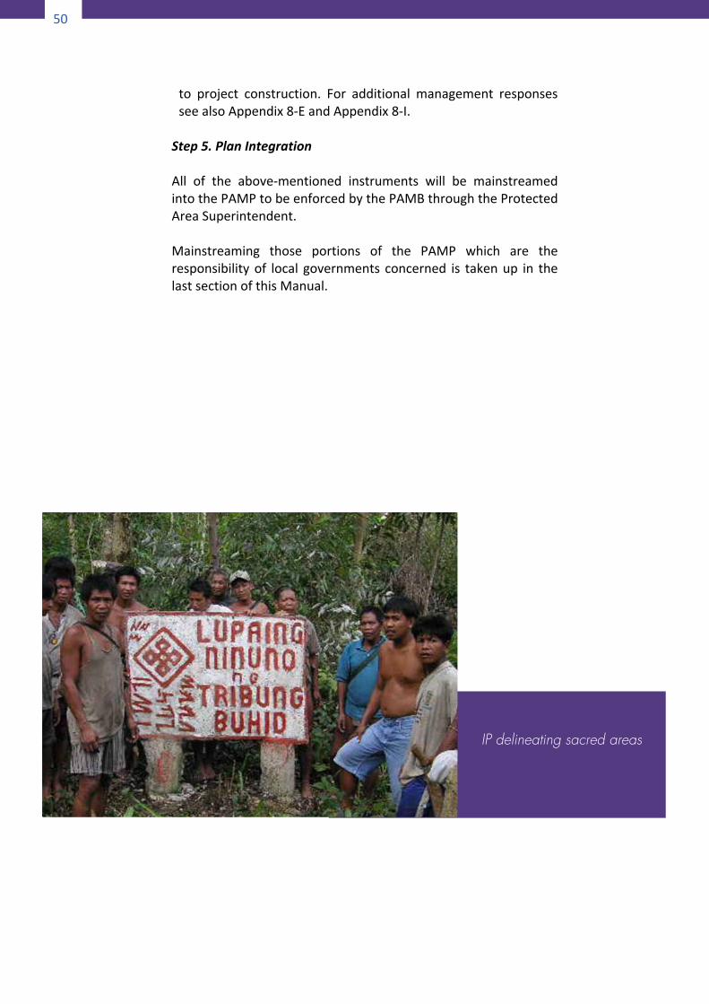
50
50
to project construction. For additional management responsesseealsoAppendix8-EandAppendix8-I.
Step5.PlanIntegrationAll of the above-mentioned instruments will be mainstreamedintothePAMPtobeenforcedbythePAMBthroughtheProtectedAreaSuperintendent.Mainstreaming those portions of the PAMP which are theresponsibilityof local governments concerned is takenup in thelastsectionofthisManual.
IP delineating sacred areas
51
PartIII
ScenarioC
FORMULATINGABIODIVERSITY-ENHANCEDANCESTRALDOMAINSUSTAINABLEDEVELOPMENT
ANDPROTECTIONPLAN
Under Scenario C there is an overlap between an ancestraldomain with CADT and a non-NIPAS protected area. This isprecisely the scenario where the provisions of Joint DENR-NCIPAdministrativeOrderNo.2008-01areapplicable.BecausetheADhasaCADTit is likelythatanADSDPPalreadyexists.Thesubjectprotectedarea isnotundertheNIPASsothere is likelytobenoPAMPexistingforthearea.Incaseslikethisitisnotnecessarytoprepare a separate PAMP for the protected area. A biodiversityconservation-enhanced ADSDPP may be sufficient for thepurposesof aharmonizedmanagementplan for theoverlappedarea.
3 Scenario C: Formulating Biodiversity Enhanced Ancestral Domain Sustainable Development and Protection Plan
52
52
3.1LegalBasisThe effort to enhance the Ancestral Domain SustainableDevelopment andProtection Planwith biodiversity conservationconsiderations finds support in an explicit provision of theIndigenousPeople’sRightsAct(IPRA)quotedhereunder:
“AncestralDomainsorportionsthereof,whichare foundto be necessary for critical watersheds, mangroves,wildlife sanctuaries, wilderness, proclaimed areas, forestcover, or reforestation as determined by appropriateagencies with the full participation of the ICCs/IPsconcerned shall be maintained, managed and developedfor suchpurposes. The ICCs/IPs concerned shall be giventhe responsibility to maintain, develop, protect andconservesuchareaswiththe fullandeffectiveassistanceofgovernmentagencies…”(Sec.58,RA8371).
3.2EnhancingtheADSDPPProcessTheprocedureforpreparingthebiodiversity-enhancedADSDPPissimilartothatofScenarioB.ButunlikeinScenarioBwheretheIPsensitivity-enhanced PAMP serves as the harmonizedmanagement plan, in Scenario C it is the biodiversityconservation- enhanced ADSDPP that serves as the harmonizedplan for the overlapped area. Inasmuch as there is a prescribedADSDPP planning process the proposed improvements andmodifications towardsbiodiversityenhancementwillbe insertedandannotateddirectlyintoeachstepoftheprocess.
3.2.1TheADSDPPFormulationProcessThe process of formulating the ADSDPP is prescribed by theNCIP through its Administrative Order No. 1, s. 2004. Theformulation process shall be guided by the principles of self-determination, participatory planning, and cultural integrity.ThemainobjectiveoftheADSDPPistoensurethesustainabledevelopmentofancestraldomainresourcesandtoenforcetherights of ICCs/IPs to their ancestral domains as well as theirrights as apeople andas citizens. Theprocess consists of ten(10)stepsasfollows(SeeFig.C.1):
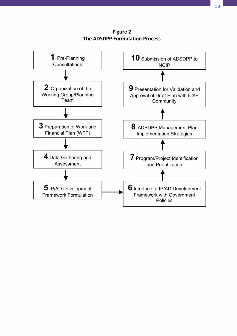
53
52
3.1LegalBasisThe effort to enhance the Ancestral Domain SustainableDevelopment andProtection Planwith biodiversity conservationconsiderations finds support in an explicit provision of theIndigenousPeople’sRightsAct(IPRA)quotedhereunder:
“AncestralDomainsorportionsthereof,whichare foundto be necessary for critical watersheds, mangroves,wildlife sanctuaries, wilderness, proclaimed areas, forestcover, or reforestation as determined by appropriateagencies with the full participation of the ICCs/IPsconcerned shall be maintained, managed and developedfor suchpurposes. The ICCs/IPs concerned shall be giventhe responsibility to maintain, develop, protect andconservesuchareaswiththe fullandeffectiveassistanceofgovernmentagencies…”(Sec.58,RA8371).
3.2EnhancingtheADSDPPProcessTheprocedureforpreparingthebiodiversity-enhancedADSDPPissimilartothatofScenarioB.ButunlikeinScenarioBwheretheIPsensitivity-enhanced PAMP serves as the harmonizedmanagement plan, in Scenario C it is the biodiversityconservation- enhanced ADSDPP that serves as the harmonizedplan for the overlapped area. Inasmuch as there is a prescribedADSDPP planning process the proposed improvements andmodifications towardsbiodiversityenhancementwillbe insertedandannotateddirectlyintoeachstepoftheprocess.
3.2.1TheADSDPPFormulationProcessThe process of formulating the ADSDPP is prescribed by theNCIP through its Administrative Order No. 1, s. 2004. Theformulation process shall be guided by the principles of self-determination, participatory planning, and cultural integrity.ThemainobjectiveoftheADSDPPistoensurethesustainabledevelopmentofancestraldomainresourcesandtoenforcetherights of ICCs/IPs to their ancestral domains as well as theirrights as apeople andas citizens. Theprocess consists of ten(10)stepsasfollows(SeeFig.C.1):
53
Figure2TheADSDPPFormulationProcess
2 Organization of the Working Group/Planning
Team
1 Pre-Planning Consultations
3 Preparation of Work and Financial Plan (WFP)
4 Data Gathering and Assessment
5 IP/AD Development Framework Formulation
6 Interface of IP/AD Development Framework with Government
Policies
7 Program/Project Identification and Prioritization
8 ADSDPP Management Plan Implementation Strategies
9 Presentation for Validation and Approval of Draft Plan with IC/IP
Community
10 Submission of ADSDPP to NCIP
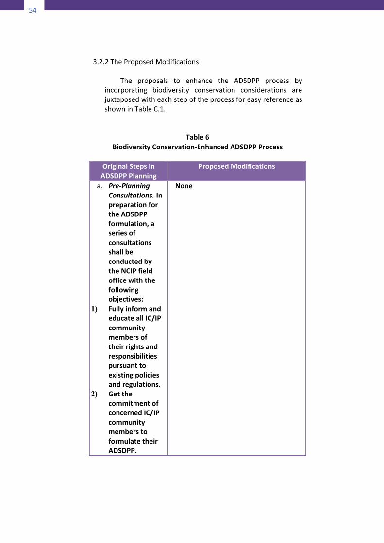
54
54
3.2.2TheProposedModifications
The proposals to enhance the ADSDPP process byincorporating biodiversity conservation considerations arejuxtaposedwitheachstepoftheprocessforeasyreferenceasshowninTableC.1.
Table6
BiodiversityConservation-EnhancedADSDPPProcessOriginalStepsinADSDPPPlanning
ProposedModifications
a. Pre-PlanningConsultations.InpreparationfortheADSDPPformulation,aseriesofconsultationsshallbeconductedbytheNCIPfieldofficewiththefollowingobjectives:
1) FullyinformandeducateallIC/IPcommunitymembersoftheirrightsandresponsibilitiespursuanttoexistingpoliciesandregulations.
2) GetthecommitmentofconcernedIC/IPcommunitymemberstoformulatetheirADSDPP.
None
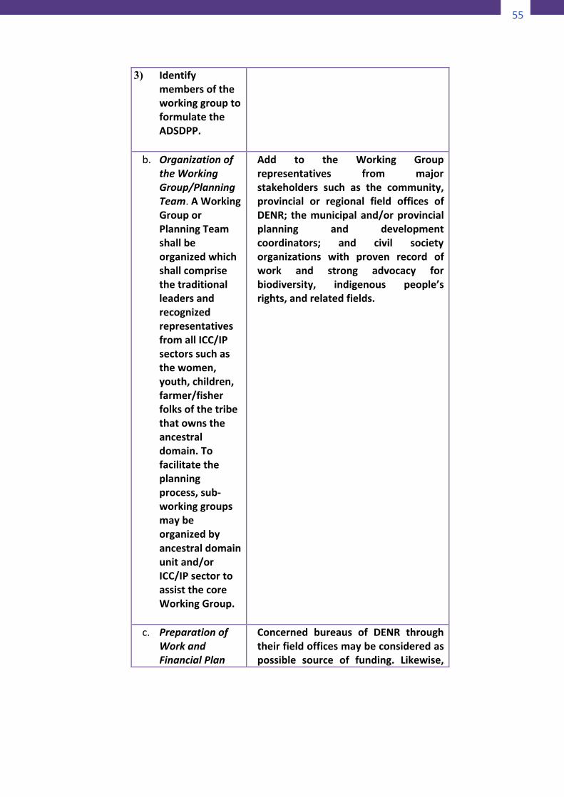
55
54
3.2.2TheProposedModifications
The proposals to enhance the ADSDPP process byincorporating biodiversity conservation considerations arejuxtaposedwitheachstepoftheprocessforeasyreferenceasshowninTableC.1.
Table6
BiodiversityConservation-EnhancedADSDPPProcessOriginalStepsinADSDPPPlanning
ProposedModifications
a. Pre-PlanningConsultations.InpreparationfortheADSDPPformulation,aseriesofconsultationsshallbeconductedbytheNCIPfieldofficewiththefollowingobjectives:
1) FullyinformandeducateallIC/IPcommunitymembersoftheirrightsandresponsibilitiespursuanttoexistingpoliciesandregulations.
2) GetthecommitmentofconcernedIC/IPcommunitymemberstoformulatetheirADSDPP.
None
55
3) IdentifymembersoftheworkinggrouptoformulatetheADSDPP.
b. OrganizationoftheWorkingGroup/PlanningTeam.AWorkingGrouporPlanningTeamshallbeorganizedwhichshallcomprisethetraditionalleadersandrecognizedrepresentativesfromallICC/IPsectorssuchasthewomen,youth,children,farmer/fisherfolksofthetribethatownstheancestraldomain.Tofacilitatetheplanningprocess,sub-workinggroupsmaybeorganizedbyancestraldomainunitand/orICC/IPsectortoassistthecoreWorkingGroup.
Add to the Working Grouprepresentatives from majorstakeholders such as the community,provincial or regional field offices ofDENR; themunicipaland/orprovincialplanning and developmentcoordinators; and civil societyorganizations with proven record ofwork and strong advocacy forbiodiversity, indigenous people’srights,andrelatedfields.
c. PreparationofWorkandFinancialPlan
Concerned bureaus of DENR throughtheirfieldofficesmaybeconsideredaspossible source of funding. Likewise,
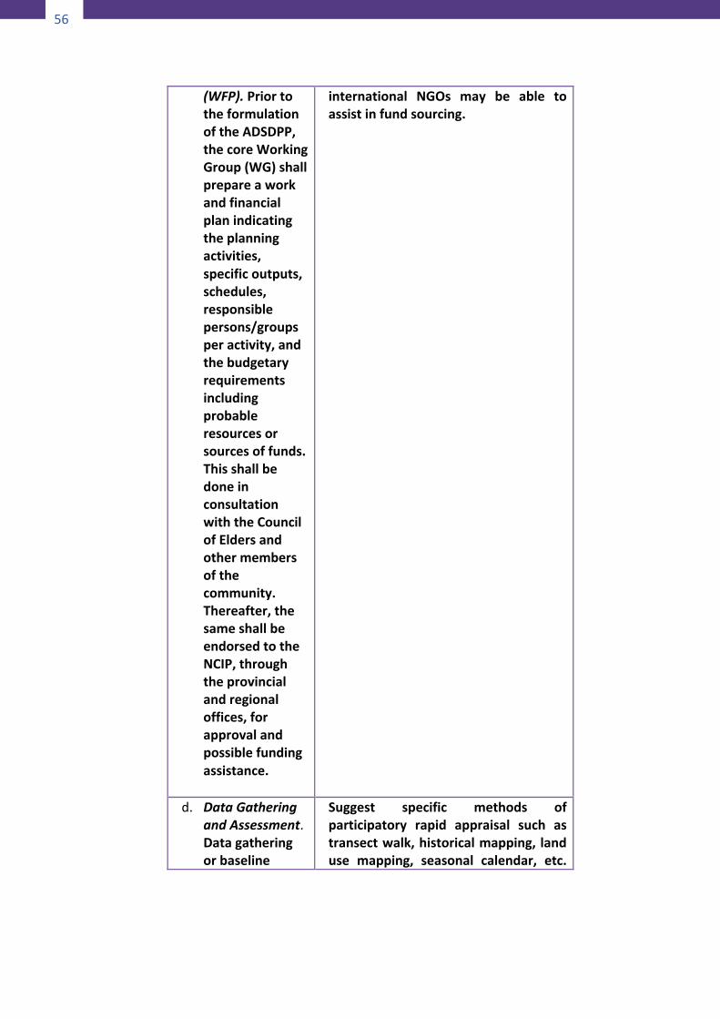
56
56
(WFP).PriortotheformulationoftheADSDPP,thecoreWorkingGroup(WG)shallprepareaworkandfinancialplanindicatingtheplanningactivities,specificoutputs,schedules,responsiblepersons/groupsperactivity,andthebudgetaryrequirementsincludingprobableresourcesorsourcesoffunds.ThisshallbedoneinconsultationwiththeCouncilofEldersandothermembersofthecommunity.Thereafter,thesameshallbeendorsedtotheNCIP,throughtheprovincialandregionaloffices,forapprovalandpossiblefundingassistance.
international NGOs may be able toassistinfundsourcing.
d. DataGatheringandAssessment.Datagatheringorbaseline
Suggest specific methods ofparticipatory rapid appraisal such astransectwalk,historicalmapping, landuse mapping, seasonal calendar, etc.
57
surveyandassessmentisthepreliminarystepintheplanningprocesstoproducetheancestraldomainprofileandsituationer.TheWorkingGroup(s)shallconductaparticipatorybaselinesurveyfocusingontheexistingpopulation,naturalresourcesdevelopmentprojects,landuse,sourcesoflivelihood,incomeandemployment,educationandotherconcerns.ThesurveyshallincludethedocumentationoftheICC/IPcultureofIKSPsorhistoricalaccountsofinventoryofdocumentsrelativetothesustainabledevelopmentandprotectionoftheancestraldomain.Likewise,itincludesthe
Refer to the menu of techniquesdescribedinAppendix1-AtoAppendix1-G. For purposes of survey andmapping for zoning, adopt the 2-zoneschemeunderNIPAS: StrictProtectionZone (SPZ) and Multiple Use Zone(MUZ). Then delineate ancestraldomainmanagementblocks/unitsanduse these as the spatial units of datainventory and analysis. Within eachmanagementblockdoa transectwalkand identify and map out areas,artifacts, resources, etc. which theparticular tribal group considers as“no-go” areas, as well as those areasdefinedinDENRDAONo.26,s.2008asconstitutingtheStrictProtectionZone.If need be, request the assistance ofthe Protected Area SuitabilityAssessment team in determining theconservation value of the naturalresources and wildlife species foundwithin the ancestral domain. Aftermapping out the SPZ continuecollectingmore informationfromeachmanagementunit.Inadditiontothosesuggested in theprecedingparagraph,check out the following data setssuggested in JAO 2008-01 if there aredata left out which have to becollected:
1)Aboutthedomaina) Location,generaldescriptionofthe
area, (e.g. topography,accessibility, slope, presence ofhazard/dangerareas, soil typeandstructure, etc.) including areacoverage and boundary of thetraditionalmanagementunit/blockbygroups,clansorcommunity.
b) Area covered by each ICC/IP usingparticular traditional andindigenous management systems
58
58
appraisalofthequalityandquantityofexistingnaturalresourcesintheancestraldomain.Thebaselinesurveyshalltargetbothsecondaryand/orprimarydatawiththeaidofsurveyinstrumentsandprocedures.
and practices including the extentand frequencyofhow the ICCs/IPsharvest/utilize their trees andotherforestresources.
c) Locationmapsof theareacoveredby the traditional domainmanagement unit/block showingtheboundariesandadjoininglots.
d) Present land uses and prevailingvegetative cover status (prevailingvegetation, including estimatedvolume or quantity of the forestresources).
e) Inventory of biodiversity resourcesin the area and strategies onrewarding upland communities formaintainingotherwatershedareas,ifany.
f) Known important forest resourcesin the area (e.g. timber and non-timber, wildlife, etc.) includingforest areas with future potentialof special forest land uses thatcould generate additional revenueforthecommunity(e.g.ecotourismarea,campsite,etc.)
g) Nature of trees and other forestresources of the area (whethernaturally growing or plantationforest) including if possible,estimated stand age, commonname,andscientificname.
h) Seeotherinformationdeemedvitalandneededforthecomprehensiveevaluationofthesustainabilityofaparticular indigenous traditionalforestmanagementpractice.
2) Aboutthecommunity
a) Indigenous political structuresincluding their ethnic/sectoralcomposition.
b) Indigenous traditional resourcerightspractices.
59
c) Approximate total populationincluding the estimatedpopulation of the communitywho are using such particularindigenous and traditionalmanagementpractices.
d)Common livelihoodactivitiesandforest-based activities includingthe number and nature of theindustry/ies making use of theresources from the traditionallymanaged area of the concernedindigenouspeople/community.
e) Traditional indigenous forestmanagement practices on forestprotectionandconservation,soiland water conservationmeasures, reforestation andagro-forestry.
Finally,checkoutScenarioAabovefora more comprehensive and moreorganizeddatainventory.The Working Group shall assess thedata/information, identify andprioritize problems/issues andconcerns, determine needs and gaps,and try to understand the underlyingcauses and how particular problemsaffect particular sectors of thecommunity. The output shall bepresented to the community forvalidationofitsaccuracyandreliabilitybefore proceeding to the succeedingsteps of the ADSDPP formulationprocess.For data analysis, use the analyticalframework suggested in ScenarioA asanalternativeorsupplementtoSWOTanalysis which is more popular butquiteshallow.(ReferbacktoFigureA-1)
60
60
e. IP/ADDevelopmentFrameworkFormulation.Immediatelyafterthevalidationoftheassesseddata,thecommunityshallcollectivelyformulatetheframeworkfortheirdevelopmentasapeopleandthesustainabledevelopmentandprotectionoftheirancestraldomain.Thisshallreflecttheircollectivevision,mission,generalobjectivesorlong-termgoals,priorityconcernsanddevelopmentstrategiesthatwillsetthedirectionoftheprogram/projectidentificationandprioritizationintheADSDPP.Theprocessshallinvolvetheevaluationofalternativedevelopmentoptionswithoutcompromiseof
Suggest a menu of evaluationtechniques such as cost-benefitanalysis, checklist of criteria, etc., toselectthemostpreferreddevelopmentoption. If you formulated your visionor goals try using the Goal-Achievement Matrix (GAM) asevaluation tool.Theunique featureoftheGAMisthatitrelatestheendswiththe means directly. (See Appendix 19for a description of the GAMtechnique.)
61
theICCs/IPs’dutiesandresponsibilitiestotheirancestraldomains.TheframeworkshallbewritteninthelanguageunderstoodbyallIC/IPcommunitymembers,andtranslatedinEnglish.
f. InterfaceofIP/ADDevelopmentFrameworkwithExistingGovernmentPolicies/Plans/Programs/Projects,RulesandRegulations.AftercompletionoftheIP/ADdevelopmentframework,othergovernmentandnon-governmentagencies,mostcrucialofwhicharetheDENR,DA,DAR,DPWH,andsoforthshallbeinvitedtopresenttheirexistingpolicies/plans/programs/projectssothattheICCs/IPswillbe
Thisstepoftheprocessshouldbesplitinto two sessions. The first session isdesigned to gather inputs fromgovernment and non-governmententities in the form of their plans,programs, projects, policies andregulationstoseehowtheseimpactontheIP/ADplansandactivities.The second session will be conductedafter Step g wherein the proposedinterventionshavebeenclassifiedandthe agencies responsible have beenidentified. This session will be anopportunityfortheIPstolobbyfortheinclusion of their proposed projectsbeforeconcernednationalagenciesforthelattertoincludeintheirbudgetfortheensuingyear.Proposals to LGUs will be taken upduring the period when the ADSDPPwillbeintegratedintotheLGUplans.Itshouldbenotedthat thebudgetcycleof local governments is different fromthatofthenationalgovernment.

62
62
fullyapprisedofdevelopmentopportunitiesaswellaslimitations.Theinputs,withpossiblecommitments,willfurtherguidetheidentificationofprogramsintheADSDPP.Ontheotherhand,otherGOsandNGOswillbeinformedoftherealdesiresandaspirationsofICCs/IPs,whichtheymayconsiderinthereviewandreformationoftheirrespectivepolicies,plans,programsandprojects.
g. Program/ProjectIdentificationandPrioritization.Basedonthedevelopmentframework,programs/projects/activitiesincludingbasicservicesrequiredshallbeidentifiedandprioritized.Abriefdescriptionofeachprogram,
To facilitate the identification ofagencies, offices, organizations andentities responsible for theimplementation of proposedprograms, projects and activities torealizethevisionandgoalsoftheplan,adopt a system of sorting theproposalsassuggestedbelow:1) Classify proposed actions into
projects, non-projects, andregulatory measures (see Appendix11).
2) Identify the proper legislative orexecutive body that has theauthority to issue the needed rulesandregulations.(SeeAppendix14).
63
projectandactivityshallbepresentedandsuggestionsonimplementationstrategiesand/ormechanismsmaybeincluded.ThepresentationshallincludeallavailableresourcesandexternalassistancethatcouldbetappedbytheIC/IPcommunity.
3) Identify the proper level ofgovernment responsible forrendering particular services anddelivering particular facilities usingSection17of the LocalGovernmentCodeasreference(seeAppendix9).
4) Prioritize projects using either the“Project-ResourceImpactMatrix”orthe “Levels of Urgency”Classification system (see Appendix16andAppendix17).
5) Prepare project briefs for priorityprojectsandtargetprobablesourcesoffundingsuchaslocalandnationalgovernments, civil societyorganizations, private sectors, andforeigndonors (seeAppendix18fortheformatandcontentsofaprojectbrief).
h. ManagementPlan.ProposedplanstoimplementandmanagetheADSDPPanditsspecificpartsshallbeindicatedtoincludethemonitoringandevaluationsystemsandtoolstobeusedinmeasuringandcheckingtheprocessofdevelopmentprogramsandprojects.TheCouncilofElders/Leadersshalloverseetheimplementation
The original ADSDPP guidelines failedto include zoning as an importantcomponent of the management plan.Zoning should no longer be neglectedthis timearound. If theADoverlapsaprotected area, the NIPAS zoningschemeshouldbeadopted.The zonesdelineated in Step 4, viz. StrictProtectionZoneandMultipleUseZoneshouldnowbefinalizedwithtechnicalassistance from DENR and LGUsconcerned.The zoningmap shall formpart of the Plan that will undergosubsequent legitimization processbeforeitcanbeimplemented.At this point the critical factors in theimplementationoftheADSDPParethebodiesthatwillbecreatedtoassisttheCouncil of Elders/Leaders. Assistancewill be needed to enforce the zoningplan. Another task wherein the CELneeds assistance is the enforcementand monitoring of the resource use
64
64
andmanagementoftheADSDPPnotwithstandingthevisitorialpowersoftheNCIP.ToassisttheCouncilofElders/Leaders(CEL),theIC/IPcommunitymayinstituteaspecialbodyorbodiesthatwilltakechargeofspecifictasksthatwillbeidentified.
management plans for the registeredAD management blocks’ STIFRMSPs.(RefertoAppendix22forethnicgroup-specific leadership and governancerolesasanadditionalguideincreatingappropriate management bodies forancestral domains cum protectedareas.)PerhapsinitiallytheICCs/IPsmayhaveto avail of assistance from relevantagencies while going through theprocessofdevelopingtheircapacitytomanage the ancestral domain-cum-protectedareaeffectively.
i. Presentation,ValidationandApprovalofDraftADSDPPwithIC/IPCommunityMembers.TheworkinggroupshallconductIC/IPcommunityassembly(ies)topresentthedraftADSDPPfortheirvalidationandapproval.ThepresentationshallbeaidedbyvisualsincludingmapsandinamannerthatisunderstoodbyallIC/IPcommunitymembers.Whenapplicable,the
None
65
EnglishtranslationoftheADSDPPshallalsobesubjecttovalidation.
j. SubmissionofADSDPPtoNCIP.Uponvalidationandapproval,thecommunitythroughitsCouncilofElders/LeadersshallsubmittheADSDPPtotheNCIPthroughtheProvincialOffice(PO).TheADSDPPshallbeincorporatedintotheMediumTermorFiveYearMasterPlanforICCs/IPs,whichshallbethebasisofprograms/projectstobeidentifiedintheannualandmediumtermbudgetaryproposalsoftheNCIPaswellasotheragencies
None
3.3MainstreamingtheBD-enhancedADSDPPintoLGUPlansAlthoughthisisnotconsideredastepintheplanformulationprocess, it is a very important step because of the followingreasons:
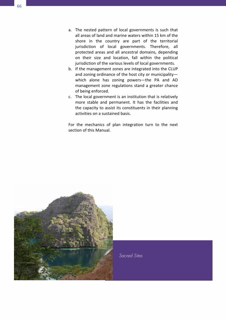
66
66
a. The nested pattern of local governments is such thatallareasoflandandmarinewaterswithin15kmoftheshore in the country are part of the territorialjurisdiction of local governments. Therefore, allprotectedareasandall ancestraldomains,dependingon their size and location, fall within the politicaljurisdictionofthevariouslevelsoflocalgovernments.
b. IfthemanagementzonesareintegratedintotheCLUPandzoningordinanceofthehostcityormunicipality—which alone has zoning powers—the PA and ADmanagementzone regulations standagreaterchanceofbeingenforced.
c. Thelocalgovernmentisaninstitutionthatisrelativelymore stable and permanent. It has the facilities andthecapacitytoassist itsconstituents intheirplanningactivitiesonasustainedbasis.
For the mechanics of plan integration turn to the nextsectionofthisManual.
Sacred Sites
67
66
a. The nested pattern of local governments is such thatallareasoflandandmarinewaterswithin15kmoftheshore in the country are part of the territorialjurisdiction of local governments. Therefore, allprotectedareasandall ancestraldomains,dependingon their size and location, fall within the politicaljurisdictionofthevariouslevelsoflocalgovernments.
b. IfthemanagementzonesareintegratedintotheCLUPandzoningordinanceofthehostcityormunicipality—which alone has zoning powers—the PA and ADmanagementzone regulations standagreaterchanceofbeingenforced.
c. Thelocalgovernmentisaninstitutionthatisrelativelymore stable and permanent. It has the facilities andthecapacitytoassist itsconstituents intheirplanningactivitiesonasustainedbasis.
For the mechanics of plan integration turn to the nextsectionofthisManual.
67
PartIII
ScenarioD
PLANNINGFORTHEINDIGENOUSCOMMUNITY-CONSERVEDAREA
The last scenario involving overlapped areas pertains toidentified protected areaswhich have not (yet) been placedunder the NIPAS sharing space with IP communities which,similarly,havenot(yet)beenawardedCADT.Aparticularareaor resource to be protected may not be placed under theNIPASatallbutitbidstobeprotectednonethelessbecauseofsome important economic, social, ecological, cultural andspiritual values it provides to the environment and humanpopulation living within or in nearby communities.Geographically, the area to be protected might lie within avitalcorridorthatlinksanetworkofprotectedareas.Similarly,the resident ICC/IP may be culturally intact with theircustomarypracticesand institutionsactively inoperationbut
3 Scenario D: Planning for the Indigeous Community-Conveseved Area
68
68
theycouldnotbegrantedCADTforthereasonthattheymayhavevoluntarilymigratedorbeendisplacedandresettledbuthavenotexercisedtheirrighttoclaimthedestinationareaastheirancestraldomain.Partofthegivenscenarioisthatboththeareatobeprotectedand the ICC/IP are under some pressure or threat to theirintegrityandsurvival.Becauseof the importanceof theareaor resource to the life of the ICC/IP they usually take theinitiative to protect the area and conserve its resources foruponitdependsthesurvivaloftheirraceandculture..4.1 Planning process for an indigenous community-
conservedarea
In planning indigenous community-conserved areas (ICCA)determine first what area to conserve and decide on whatgovernancemode to adopt for the conserved area. Then onthebasisofthechosengovernancemodedeterminewhetheranyofthethreescenarios–ScenarioA,ScenarioBorScenarioC – is applicable. If none of the scenarios fits, then use theprocessproposedbelow..4.1.1 Determiningwhatareastoconserve
a. KeyBiodiversityAreas(KBA)not includedintheinitial
NIPAS nor are currently being considered to becomeadditional components (Ong, inHaribon, 2002)whichare known to harbor a predominantly indigenouspopulation.
b. Ancestral domains or adopted habitats of ICCs/IPswhich are experiencing some form of threat and arealso putting at risk the indigenous community’s verysurvivalandculturalintegrity.
4.1.2 Determining what governance mode is
appropriate for each type of area to beconserved
a. Inthecaseofa:1)EstablishasNIPASprotectedarea,2)ApplyforCADT,
69
3)Doboth.If any of the above options is feasible then plan the
areausingtheapproachunderScenarioAorScenarioB.
b. Inthecaseofb,applyforCADTandplantheancestral
domainadoptingtheapproachunderScenarioC.c. Ifnoneoftheoptionsforaandb isfeasible,planas
anindigenouscommunity-conservedarea(ICCA).4.2 StepsinICCAPlanning
Foramodelmethodologywemayadoptthe“StagesofSystematic Conservation Planning” proposed by Sahotra(2012) as the basic outline and modify it to suit localconditionsandrealities.(RefertoAppendix21.)
Step1DelineatetheplanningareaThere are two overlapping concerns in this study whichdetermine to a large extent how the boundaries of theplanning area are to be delineated: the concern forbiodiversity conservation and the interests of the ICCs/IPswhosehabitathappenstobethesameareathatissoughttobe conserved. To delineate the ICCA planning boundarytherefore requires the reconciliation of two sets of criteria,one for selection of biodiversity reserves and the other fordeterminingasustainableterritorythatwillallowaparticularethnicgrouptoliveandflourishasahumancommunity.Forthefirstsetofcriteria,i.e.,forselectionanddelineationofbiodiversity reserves, letusborrowfromtheCommonwealthofAustralia as citedbyBakarr and Lockwood ( in Lockwood,M.et.al.,eds.,2006):a. Boundaries should be set in a landscape context with
strongecologicalintegritysuchaswatersheds.b. Large reserved areas are preferable to small reserved
areas.c. Boundary-to-area ratios should be minimized and linear
reserves should be avoided where possible except forriverinesystems.
d. Reserve designs should aim to minimize the impact ofthreateningprocesses,particularlyfromadjoiningareas.
70
70
e. Reserves should be linked through a variety ofmechanisms,whereverpracticable,acrossthelandscape.
Forthesecondsetofcriteria,namely,determiningwhatcouldbeanoptimalterritoryfor ICCs/IPs,therehastobeawayofclassifying indigenous people in terms of the geographicalrangewithinwhichtheyeffectivelycarryouttheircustomarysocial, cultural, political and livelihood activities. We couldturn for help to anthropologist F. Landa Jocano (1998) whodeveloped five categories of indigenous communitiesaccording to the level of their social organization. Thesecategoriesandthetypicalsettlementpatternassociatedwitheachcategoryarebrieflydescribedbelow:a. Pisan (campsite) – an Agta term for small exogenous
groups living in campsites, possessing simple technology,andlivingbyforagingandhunting.Theyaremostlyfoundin the fringesof interiorhighlands. Included in thisgroupare the Aeta, Agta, Ata, Ati, Baluga, Batak, Dumagat,Mamanwa,andTasaday.
b. Puro (settlement) – a “sulod” word for semi-sedentary,amorphousaggregateofpersonswhomaynotberelatedtooneanother.Theyliveinparticularnamedsettlementsbut are occasionally mobile being swidden or kaingincultivators. Examples of this group are theMangyan andtheT’boli.
c. Ili(village)–aBontocwordfor“village”,consistsofpeoplelivinginvillagesofvarioussizes,mostlylargeandcompact.Thepopulation is larger and less dispersed thanPisanorPuro. Villages are usually divided into named politicalwardsoragriculturalunits.Thesettlementsarecomposedofvillagesoftendispersedwithinornearaclusteredseriesofirrigatedterracesandotherholdings,nearstreamsandsurroundedbyterracedricefields,orclusteredincanyonsorsmallhillslopeterraces.MembersofthisgroupincludetheIfugao,Bontoc,KalingaandManobo.
d. Magani (district) – a Manobo word for “renownedwarrior”, used to represent a social organization headedby warrior chiefs. Social stratification consists of thebagani or mengal families led by males of unquestionedreputation inwarfareandcouragewhooccupy theapex;the commoners who own some property, dominateoccupational specializations, and have medium incomewhoare in themiddle; and the slaveswhoareproperty-less who occupy the bottom of the social strata.
71
Settlementsconsistofaseriesofvillagesformingadistrict.ExamplesaretheAgusanManobo,Mandaya,andnorthernKalinga.
e. Banwa (domain) – a Manuvu word for “domain”. Thisgroup is the most structurally complex. There are a fewexamples found only in Mindanao. Members live in self-contained villages located in adjacent and contiguousterritory bound together as a single socio-political unitunder a centrally located political office of the datu.Several villages constitute a banwa. The villages areindependent and self-sufficient units that interact withone another. Kinship is important for interpersonal andinterfamilial relations but not significant for definingbanwa identity. The community,more than the familyorneighborhood,isthecenterofimportantactivities.
So what is a sustainable territory for an IP community? Itwould seem from the above descriptions that the mostextensive territory should be reserved for the nomadicforagersandhunters.Correspondingly, themoresedentaryaparticulargroupthesmaller thegeographicalarea theyneedto sustain their livelihood, culture and lifestyle. Thisgeneralization, however, is intended to serve as asupplementarysetofcriteria,notasubstitutetotheprincipleofself-delineation.After delineating the two areas separately, overlay the twotracings and trace the boundaries of a third polygon thatrepresentstheclosestfitbetweenthetwoareas.Otherwise,ifone area is completely contained in the other, adoptwhicheveristhebiggerareaasthefinalplanningarea.Step2IdentifyallstakeholdersStakeholders are those social actors who have a direct,significant and specific stake in a given territory or a set ofnaturalresources.Thismaybeduetogeographicalproximity,historical association with the place, dependence on theresources for livelihood, institutional mandate, economicinterest, or a variety of other concerns. Borrini-FeyerabendandBrown(inLockwood,et.al.,eds,2002)suggestawaytodistinguish true stakeholders namely, those who are usuallyaware of their own interests in the management of theterritory or set of resources;who possess specific capacities
72
72
and comparative advantages for such management; and arewillingtoinvestspecificresourcestowardsuchmanagement.Prospects for successful implementation are enhanced if allthe relevant agents participate in the planning process fromthe beginning. The stakeholders will also have a role inimplementing and monitoring the conservation plan at laterstages.Forabetterunderstandingoftheirattitudesandlevelofparticipationstakeholdersmaybegroupedintothosewhowill be affected by policies and actions during planimplementationandthosewhohavenopecuniaryinterest inthe outcomes of the plan. Further, the latter group may besplit into those who are mandated by law or by theirinstitutionalchartertoprovideinputsandinvestresources inthe undertaking and those who are participating voluntarilydriven solely by their own conviction or advocacy. Thefollowing is a list of the potential stakeholders in anyprotectedareamanagement.PotentialProtectedAreaStakeholders(adaptedfromBorrini-FeyerabendandBrown,1997)a. Agencieswithlegaljurisdictionovertheprotectedareaat
municipal,provincialornationallevelb. Individuals, families and households (e.g. landowners
withinoraroundtheprotectedarea)c. Community-basedgroupssuchasfarmers’associationsd. Local traditional authorities such as councils of elders or
traditionalchiefsoftribalcommunitiese. Electedofficialsatbarangay,municipal,orprovinciallevelf. Appointive officials of local and national government
service departments such as health, education, welfare,agriculture,forestry,police,fireprotection,andthelike
g. Environmental or developmentNGOswith local, nationalorinternationalnetworks
h. Commercial and industrial enterprises organized at local,nationalorinternationallevel
i. Universitiesandresearchinstitutionsj. Theinternational(developmentassistance)communityStep3CompileandassessdataPlanning the conservation of “lived-in” landscapes requiresgeophysical, biological, economic and socio-political data.Sufficientresourcesaretypicallynotavailabletocollectallthedata that would be useful. Data collection should be cost-
73
effectiveandfocusedonthoseparametersthatarethemostimportant.Whatdataaremostrelevantisdeterminedbythestudyregionandtheplanninggoalsandobjectives. (Refer tothe relevantportionof “HarmonizedPlanning” in ScenarioAfor a menu of suggested data sets and some participatorytechniquesofdatagathering.ReferalsotoAppendix15.)Step4EvaluatebiodiversityandconservationvaluesCaremustbetakentoensurethatbiodiversityisappropriatelyrepresented and quantified. If there are no independentprofessionals available, it is suggested that the DENR teamthat conducts the Protected Area Suitability Assessment beengagedtoascertainthequalityandquantityofconservationvaluespresentintheplanningarea.Also,refertoAppendix3-Bforadditionalcriteria.Step5AssessbiodiversitythreatsandareavulnerabilitiesProbablytheplanningareamayhavebeenselectedpreciselybecauseofbuilt-invulnerabilitiesor thepresenceofexternalthreats (Refer to Appendix 5 for an inventory of potentialthreats toprotectedareas).Suchvulnerabilitycanarise fromsocio-political factors (for instance, influx of refugees fleeinginsurgency), economic pressures (such as mining, logging,ranching, and commercial fish farming) development impact(suchasmajorpublicworksprojectsexpectedtotraverseanyportionoftheplanningarea)andexistingecologicalfactors,orglobal change factors (such as climate change). (Refer toAppendices 23 and 24 for the list of possible impacts ofclimate change on indigenous people living in tropicalecosystemsandincoastalandmarineenvironments.)Step6SetconservationgoalsandtargetsFormulatetwosetsofgoals:thegeneral long-termgoalsandthe specific objectives and targets. The general goals shouldbe stated in the form of desired outcomes. Then for eachdesiredoutcomegeneratetangible,observableormeasurableindicatorsofsuccess.Thensetspecificobjectivestargetingthepartialorfullattainmentofthesuccessindicators.Examplesofgeneralandspecificgoals:General goal: Major threats to biodiversity and ecologicalintegrityremoved.
74
74
Specificobjectives:a. Toprovidelivelihoodalternativestocounterthethreatof
unsustainablenaturalresourceextractionpractices.b. Toregulatepoachingofwildlife,huntingandfishingduring
spawningseason.c. Tosetupaquarantineservicetochecktheintroductionof
exoticspeciesoffloraandfauna.Another approach to goal formulation is to start with theanalysis of the problems and issues identified in step 4 andstep 5.Determine the cause-effect relationship of the issuesandarrangethemina“problemtree”.Thenusingthedictum“A goal is the inverse of a problem”, negate every problemandtransformtheproblemtreeintoan“objectivestree”.Step7Formulatestrategies,programs,regulationsandotherformsofinterventiontoachievethegoalsandtargetsA systematic way to generate appropriate interventions toachievethegoalsandtargetsofconservationistogobacktothemajorcomponentsoftheplanningareaasidentifiedinthedata collection and anaslysis (Steps 3, 4 and 5) namely,biophysical, biological, socio-cultural and politico-economic.Then for each major component determine the appropriatetypes of intervention to address the issues, concerns andthreats. Suppose that all proposed interventions can begrouped into preemptive (enforcement of zoning and otherregulationsintendedtopreventcertainunwantedbehaviororto minimize certain risks or remove certain threats),restorative(rehabilitationofdegradedhabitatsanddisturbedecosystems or re-introducing certain species that hadvanished), and developmental (investments in projectsdesignedtocreatealong-termpositiveimpactonthequalityoflifeoftheresidentcommunityandenhancetheintegrityofthe biophysical environment). Cross tabulate the majorcomponentsagainst thecategoriesof interventionsas in thetable below. This creates management cells, each cellrepresenting a particular component and a specific actionproposed for that component. Examine each of the 12 cellscreated and fill up those cells requiring specific forms ofintervention commensurate to the identified problems andissues.
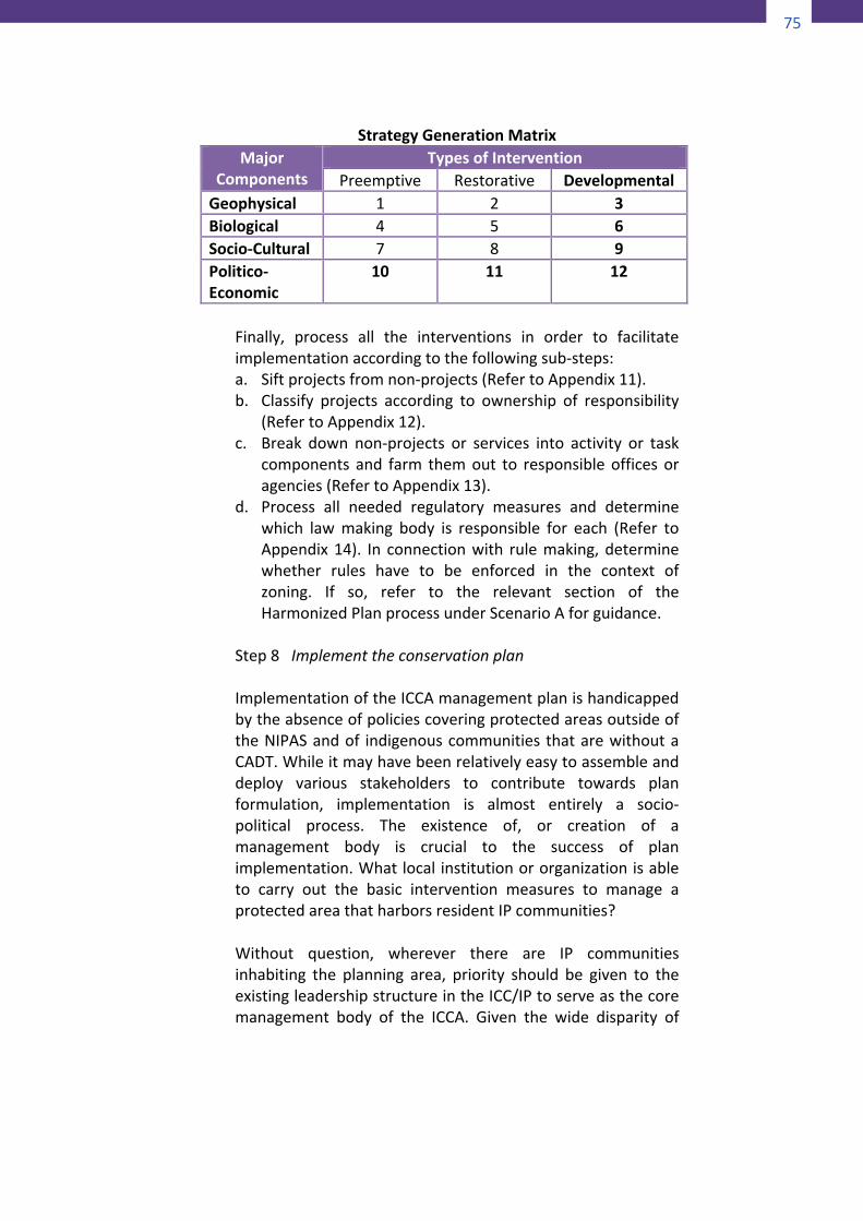
75
74
Specificobjectives:a. Toprovidelivelihoodalternativestocounterthethreatof
unsustainablenaturalresourceextractionpractices.b. Toregulatepoachingofwildlife,huntingandfishingduring
spawningseason.c. Tosetupaquarantineservicetochecktheintroductionof
exoticspeciesoffloraandfauna.Another approach to goal formulation is to start with theanalysis of the problems and issues identified in step 4 andstep 5.Determine the cause-effect relationship of the issuesandarrangethemina“problemtree”.Thenusingthedictum“A goal is the inverse of a problem”, negate every problemandtransformtheproblemtreeintoan“objectivestree”.Step7Formulatestrategies,programs,regulationsandotherformsofinterventiontoachievethegoalsandtargetsA systematic way to generate appropriate interventions toachievethegoalsandtargetsofconservationistogobacktothemajorcomponentsoftheplanningareaasidentifiedinthedata collection and anaslysis (Steps 3, 4 and 5) namely,biophysical, biological, socio-cultural and politico-economic.Then for each major component determine the appropriatetypes of intervention to address the issues, concerns andthreats. Suppose that all proposed interventions can begrouped into preemptive (enforcement of zoning and otherregulationsintendedtopreventcertainunwantedbehaviororto minimize certain risks or remove certain threats),restorative(rehabilitationofdegradedhabitatsanddisturbedecosystems or re-introducing certain species that hadvanished), and developmental (investments in projectsdesignedtocreatealong-termpositiveimpactonthequalityoflifeoftheresidentcommunityandenhancetheintegrityofthe biophysical environment). Cross tabulate the majorcomponentsagainst thecategoriesof interventionsas in thetable below. This creates management cells, each cellrepresenting a particular component and a specific actionproposed for that component. Examine each of the 12 cellscreated and fill up those cells requiring specific forms ofintervention commensurate to the identified problems andissues.
75
StrategyGenerationMatrix
MajorComponents
TypesofInterventionPreemptive Restorative Developmental
Geophysical 1 2 3Biological 4 5 6Socio-Cultural 7 8 9Politico-Economic
10 11 12
Finally, process all the interventions in order to facilitateimplementationaccordingtothefollowingsub-steps:a. Siftprojectsfromnon-projects(RefertoAppendix11).b. Classify projects according to ownership of responsibility
(RefertoAppendix12).c. Break down non-projects or services into activity or task
components and farm themout to responsibleofficesoragencies(RefertoAppendix13).
d. Process all needed regulatory measures and determinewhich lawmaking body is responsible for each (Refer toAppendix14). In connectionwith rulemaking,determinewhether rules have to be enforced in the context ofzoning. If so, refer to the relevant section of theHarmonizedPlanprocessunderScenarioAforguidance.
Step8ImplementtheconservationplanImplementationoftheICCAmanagementplanishandicappedbytheabsenceofpoliciescoveringprotectedareasoutsideoftheNIPASandof indigenouscommunities thatarewithoutaCADT.Whileitmayhavebeenrelativelyeasytoassembleanddeploy various stakeholders to contribute towards planformulation, implementation is almost entirely a socio-political process. The existence of, or creation of amanagement body is crucial to the success of planimplementation.Whatlocal institutionororganizationisableto carry out the basic intervention measures to manage aprotectedareathatharborsresidentIPcommunities?Without question, wherever there are IP communitiesinhabiting the planning area, priority should be given to theexistingleadershipstructureintheICC/IPtoserveasthecoremanagement body of the ICCA. Given the wide disparity of
76
76
tribalgroupsintermsoflevelofsocialorganization,however,some tribes may not be ready to assume managementresponsibilities for their areas unaided. According to theclassification of ethnic groups developed by Jocano cited inStep2above,tribalgroupsbelongingtotheIli,Magani,andBanwa with their well-developed political structurescharacterizedbyhierarchicalpositionsandwell-differentiatedfunctions, a few of them having no less than a constitutionand by-laws, may be able to take on managementresponsibilitiesfortheirrespectiveprotectedareasaftersomeorientation and capability building. Capability building isnecessary considering that the basic interventions they willimplementwhichinclude,butarenotlimitedto:a)removalofthreats to the integrity of the protected area, b) promotingthe well-being of the resident communities, c) active anddirect recoveryand rehabilitationofdegraded resourcesanddisturbed ecosystems, and d) promoting stakeholderinvolvement and drumming up societal support for theprotected area, are vastly more demanding than thecustomarygovernanceactivitiestheir tribalcouncilsareusedtoperform(RefertoAppendix22).In the caseof areas inhabitedby thenomadicPisan and thesemi-sedentary Puro which have no social stratification, noformal political institution that defines power and authority,and no permanent leaders, management of the conservedarea may be handled by some other body withrepresentativesfromthetribalgroupsconcerned.Perhapsitisinthe lattercasewheretheco-managementprovisionoftheLocalGovernmentCode(Sec.3,i)applies.Amemorandumofagreement could be forged among the appropriate level oflocal government, the DENR and the NCIP, and under thetermsoftheagreementthe localgovernmentconcernedwillassume management responsibility over the ICCA through aduly organized committee under the barangay, municipal orprovincialdevelopmentcouncilsand,whereitexists,theLocalGovernmentEnvironmentandNaturalResourcesOffice.Step9MonitorperformanceBiodiversity conservation is not a one-off process ofdelineating conservationareanetworks that can thenbe leftto persist on their own. Both human encroachments andnatural changes can alter the conservation status of a
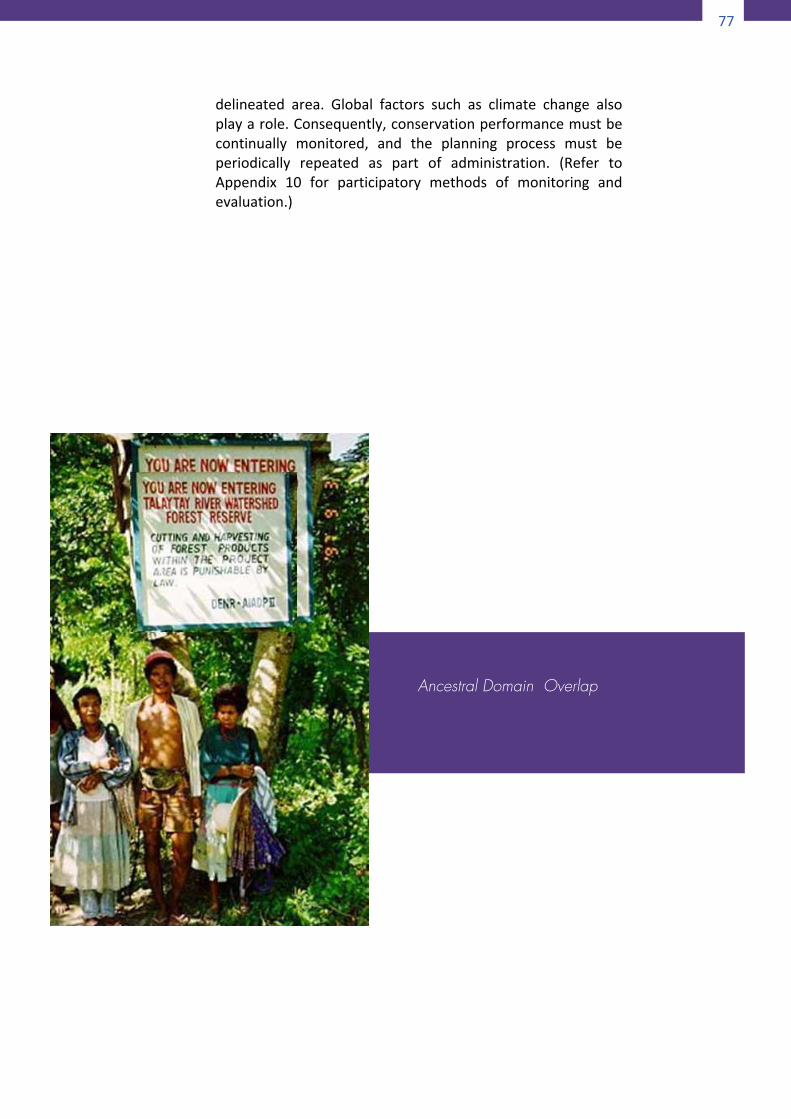
77
76
tribalgroupsintermsoflevelofsocialorganization,however,some tribes may not be ready to assume managementresponsibilities for their areas unaided. According to theclassification of ethnic groups developed by Jocano cited inStep2above,tribalgroupsbelongingtotheIli,Magani,andBanwa with their well-developed political structurescharacterizedbyhierarchicalpositionsandwell-differentiatedfunctions, a few of them having no less than a constitutionand by-laws, may be able to take on managementresponsibilitiesfortheirrespectiveprotectedareasaftersomeorientation and capability building. Capability building isnecessary considering that the basic interventions they willimplementwhichinclude,butarenotlimitedto:a)removalofthreats to the integrity of the protected area, b) promotingthe well-being of the resident communities, c) active anddirect recoveryand rehabilitationofdegraded resourcesanddisturbed ecosystems, and d) promoting stakeholderinvolvement and drumming up societal support for theprotected area, are vastly more demanding than thecustomarygovernanceactivitiestheir tribalcouncilsareusedtoperform(RefertoAppendix22).In the caseof areas inhabitedby thenomadicPisan and thesemi-sedentary Puro which have no social stratification, noformal political institution that defines power and authority,and no permanent leaders, management of the conservedarea may be handled by some other body withrepresentativesfromthetribalgroupsconcerned.Perhapsitisinthe lattercasewheretheco-managementprovisionoftheLocalGovernmentCode(Sec.3,i)applies.Amemorandumofagreement could be forged among the appropriate level oflocal government, the DENR and the NCIP, and under thetermsoftheagreementthe localgovernmentconcernedwillassume management responsibility over the ICCA through aduly organized committee under the barangay, municipal orprovincialdevelopmentcouncilsand,whereitexists,theLocalGovernmentEnvironmentandNaturalResourcesOffice.Step9MonitorperformanceBiodiversity conservation is not a one-off process ofdelineating conservationareanetworks that can thenbe leftto persist on their own. Both human encroachments andnatural changes can alter the conservation status of a
77
delineated area. Global factors such as climate change alsoplayarole.Consequently,conservationperformancemustbecontinually monitored, and the planning process must beperiodically repeated as part of administration. (Refer toAppendix 10 for participatory methods of monitoring andevaluation.)
Ancestral Domain Overlap
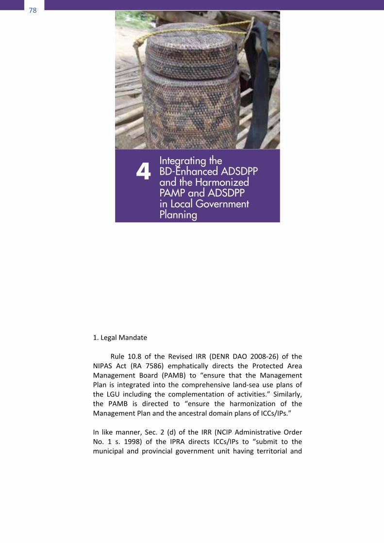
78
78
PartIV
INTEGRATINGTHEBD-ENHANCEDADSDPP
ANDTHEHARMONIZEDPAMPANDADSDPPINLOCALGOVERNMENTPLANNING
1.LegalMandate
Rule 10.8 of the Revised IRR (DENR DAO 2008-26) of theNIPAS Act (RA 7586) emphatically directs the Protected AreaManagement Board (PAMB) to “ensure that the ManagementPlan is integrated into the comprehensive land-sea use plans ofthe LGU including the complementation of activities.” Similarly,the PAMB is directed to “ensure the harmonization of theManagementPlanandtheancestraldomainplansofICCs/IPs.”In likemanner, Sec. 2 (d) of the IRR (NCIP AdministrativeOrderNo. 1 s. 1998) of the IPRA directs ICCs/IPs to “submit to themunicipal and provincial government unit having territorial and
4Integrating the BD-Enhanced ADSDPP and the Harmonized PAMP and ADSDPP in Local Government Planning
79
78
PartIV
INTEGRATINGTHEBD-ENHANCEDADSDPP
ANDTHEHARMONIZEDPAMPANDADSDPPINLOCALGOVERNMENTPLANNING
1.LegalMandate
Rule 10.8 of the Revised IRR (DENR DAO 2008-26) of theNIPAS Act (RA 7586) emphatically directs the Protected AreaManagement Board (PAMB) to “ensure that the ManagementPlan is integrated into the comprehensive land-sea use plans ofthe LGU including the complementation of activities.” Similarly,the PAMB is directed to “ensure the harmonization of theManagementPlanandtheancestraldomainplansofICCs/IPs.”In likemanner, Sec. 2 (d) of the IRR (NCIP AdministrativeOrderNo. 1 s. 1998) of the IPRA directs ICCs/IPs to “submit to themunicipal and provincial government unit having territorial and
79
politicaljurisdictionoverthemtheirADSDPPinorderforthesameLGU to adopt and incorporate the same in the MunicipalDevelopmentPlan,MunicipalAnnual InvestmentPlan,ProvincialDevelopment Plan, and Provincial Annual Investment Plan.” TheRevisedIRR(NCIPAONo.1s.2004)reiteratesthesamedirectiveandadds:“TheLGUsarealsoencouragedtoprovidefinancialandtechnical assistance in the implementation of the ICCs/IPs’developmentplans”(Sec.9).
2. RationaleforIntegration1) Allprotectedareasandallancestraldomains,dependingon
theirsizeandlocation,fallwithinthepolitical jurisdictionofthevariouslevelsoflocalgovernments.Localgovernmentsinturn receive their share in the Internal Revenue Allotmentaccording to the size of their territory, including theprotectedareasandancestraldomains,amongotherfactors.It behooves LGUs therefore to use their IRA share for theprotectionandupkeepofeveryportionoftheirterritoryandto promote the well-being of all inhabitants thereof.IntegratingtheADSDPPandthePAMPintotheLGUplanswillprovide guidance to the local officials on what additionalpolicies they need to formulate and what priority projectsshouldreceiveallocationfromthelocalbudget.
2) Both the ancestral domain and the protected area have
delineated management zones. Management zones withinNIPASareasareenforcedbythePAMBthroughthePASu.Fortheirpart,ancestraldomainzonesaretobeenforcedbytheCouncil of Elders/Leaders but the level of preparedness ofsuch indigenous political structures varies according to thelevelof socialorganizationofparticular tribal groups. If themanagementzonesareintegratedintotheCLUPandzoningordinanceofthehostcityormunicipality,thezoningpowersof the latter could be brought to bear toward a moreeffective enforcement of PA and AD management zoneregulations.
3) Thelocalgovernmentisaninstitutionthatisrelativelymore
stableandpermanent.Ithasthefacilitiesandthecapacitytoassist its constituents in their planning activities on asustained basis. For example, a very important service anLGUcanpossiblyprovideisthatofarchivingtheprofile,IKSP,ethnography, maps and other forms of information which
80
80
the IP communitymay not yet be in a position tomanage,and updating the same data sets in connection with theperiodicupdatingof theLGU’ssocio-economicorecologicalprofile.
4) Plan integration is consistent with the concept of co-
managementoftheenvironmentandnaturalresources.Thelegalbasesofco-managementaretherelevantprovisionsofthe Local Government Code (Sec. 3, i), the JointMemorandum-Circular of theDENRand theNCIP regardingmanagement of protected areas within ancestral domains(JMCNo. 2007-01), and the IRR of both theNIPASAct andtheIPRA,asnotedabove.
3. Determining at What Level of LGU to Integrate the
ADSDPP/PAMP
3.1CategoriesofAD/PAbygeographicalextent Ifwetakethecity/municipal levelasthereferencepoint,we create three categories of AD/PA according togeographicalextentofcoverage:1) Coterminous - an AD or PA whose boundaries exactly
coincidewiththoseofacity/municipality.2) Over-bounded– anADorPA that is confined inoneora
fewbarangayswithinonecity/municipality.3) Under- bounded – an AD or PA that straddles several
cities/municipalities within one province or across anumberofcontiguousprovinces
3.2 Wheretointegrate
Indeterminingatwhatgeo-political level theharmonizedmanagement plans or the biodiversity-enhanced ADSDPPshouldbemosteffectively integrated,wecanuse theabovecategoriesasabasis.Asageneralprinciple:
a. Inthecaseofcoterminousdomainsthereisnoneedtointegrate.TheADSDPPcanserveasthemandatedplanof the city/municipality concerned provided thatcustomary concepts and terminologies are translatedinto the usual nomenclature and account codesconsistent with government procedures. More details
81
on this in thenext sectionbelow. (terminologies tobeusedwillbefromDILGandHLURB/government).
b. Over-bounded domains should mainstream their plans
intothecity/municipalitywheretheyarelocated.Over-bounded domains have the potential to adoptalternativeapproachestointegrationasdiscussedinthenextsectionbelow.
c. Under-bounded domains are better linked to the
provincialgovernment.Becausesometribalgroupsarethinly spread across a wide area straddling severalmunicipalities,ADSDPPplanningshouldbeorchestratedat the provincial level and the plan output integratedinto the provincial plans. In cases where themanagement of the domain involves enforcement ofzoning regulations the zoning component ofprovincially-preparedADSDPPsshouldbemainstreamedinto the zoning ordinances of component cities andmunicipalities because only cities and municipalitieshave zoning powers. Also, where the neededgovernment intervention requires immediate frontlineservices suchasprimaryhealth care, literacyprogramsand the like, mainstreaming into the municipal levelplanswould yieldquicker results.Requests for fundingof capital investment projects however, will probablyhave greater chances of success if made at theprovinciallevel.
4. ApproachestoPlanIntegrationTheconceptofmainstreaminghastwodimensions:1)incorporationofoneplanintoanotherplanand2)organicintegrationofoneormoreplansintoaseamlesswhole.
4.1PlanincorporationIncorporationisthetraditionalapproachtomainstreaming.Itinvolvesthephysicalgraftingofaplandocumentintoanotherplandocument.Howis itnormallydone?First,thetwoplansarepreparedseparatelyandatdifferenttimesasstand-aloneplans by different bodies expressly tasked to produce thedesired output, e.g. PAMP or ADSDPP and the mandatedcomprehensive plans of the LGU. When the plans are
82
82
completed the ADSDPP or PAMP are then grafted into theexistingcomprehensiveplansoftheLGU.Thegraftingcanbedoneintwoways:1)The“grafted”planisadoptedinitsentiretyasanintegralpartofthe“host”plan,inthiscasetheCLUPorCDPthroughaSanggunian resolution. The two plans may or may not beboundtogetherunderacommoncover.2)Literallytearaparttheplantobemainstreamedandinsertthe pieces into relevant sections of the LGU comprehensiveplans. The mechanical insertion however hardly makes thegraftedelements integralandorganic to thehostdocument.Worse,aftertheadoptionnothingmuchelsehappens.4.2“In-process”integrationThesecondapproachcanbedubbed“inprocess”method. Itinvolves theuseofanyorallof thecomponentsof the localplanningsystemasentrypoints.Underthisapproachthereisreasonable assurance of seamless integration of plandocuments as well as institutionalization of systems andprocedures.Butyoumustbe familiarwith the localplanningsystemtobeginwith.
4.2.1TheLocalPlanningSysteminthePhilippinesThe Local Planning System as mandated by the LocalGovernmentCode (RA7160) isa four-component systemdesigned to answer the questions:Who are supposed toplan? What plans are they supposed to make? How aretheygoing tomake them?Andwhat resourcesand toolsdolocalgovernmentshavewithwhichtoimplementtheirplans? The first question pertains to the local planningstructure, the second refers to the mandated plans, thethird is about the planning processes, and the fourthpertains to the authority levers with which localgovernmentsimplementtheirplans.1)ThelocalplanningstructureOn the structure for local planning, there are twocomponents – political and technical. The political
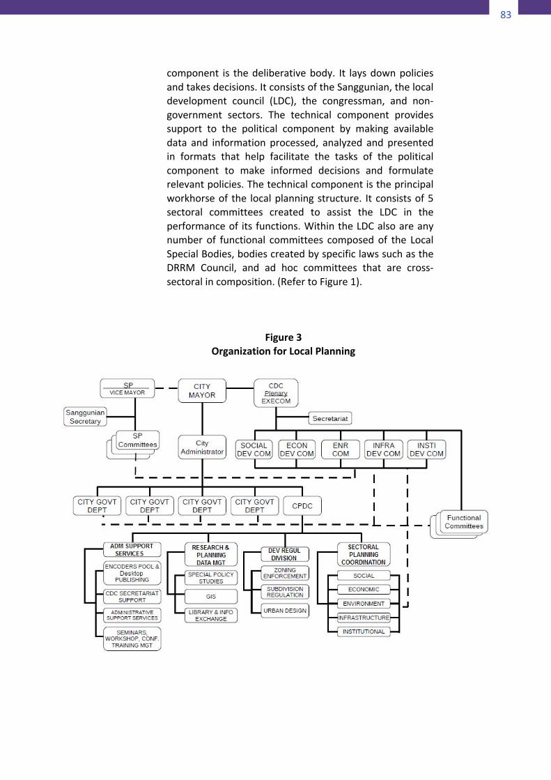
83
82
completed the ADSDPP or PAMP are then grafted into theexistingcomprehensiveplansoftheLGU.Thegraftingcanbedoneintwoways:1)The“grafted”planisadoptedinitsentiretyasanintegralpartofthe“host”plan,inthiscasetheCLUPorCDPthroughaSanggunian resolution. The two plans may or may not beboundtogetherunderacommoncover.2)Literallytearaparttheplantobemainstreamedandinsertthe pieces into relevant sections of the LGU comprehensiveplans. The mechanical insertion however hardly makes thegraftedelements integralandorganic to thehostdocument.Worse,aftertheadoptionnothingmuchelsehappens.4.2“In-process”integrationThesecondapproachcanbedubbed“inprocess”method. Itinvolves theuseofanyorallof thecomponentsof the localplanningsystemasentrypoints.Underthisapproachthereisreasonable assurance of seamless integration of plandocuments as well as institutionalization of systems andprocedures.Butyoumustbe familiarwith the localplanningsystemtobeginwith.
4.2.1TheLocalPlanningSysteminthePhilippinesThe Local Planning System as mandated by the LocalGovernmentCode (RA7160) isa four-component systemdesigned to answer the questions:Who are supposed toplan? What plans are they supposed to make? How aretheygoing tomake them?Andwhat resourcesand toolsdolocalgovernmentshavewithwhichtoimplementtheirplans? The first question pertains to the local planningstructure, the second refers to the mandated plans, thethird is about the planning processes, and the fourthpertains to the authority levers with which localgovernmentsimplementtheirplans.1)ThelocalplanningstructureOn the structure for local planning, there are twocomponents – political and technical. The political
83
component is thedeliberativebody. It laysdownpoliciesandtakesdecisions.ItconsistsoftheSanggunian,thelocaldevelopment council (LDC), the congressman, and non-government sectors. The technical component providessupport to the political component by making availabledata and information processed, analyzed and presentedin formats that help facilitate the tasks of the politicalcomponent to make informed decisions and formulaterelevantpolicies.Thetechnicalcomponentistheprincipalworkhorseof the localplanningstructure. Itconsistsof5sectoral committees created to assist the LDC in theperformanceof itsfunctions.WithintheLDCalsoareanynumber of functional committees composed of the LocalSpecialBodies,bodiescreatedbyspecificlawssuchastheDRRM Council, and ad hoc committees that are cross-sectoralincomposition.(RefertoFigure1).
Figure3
OrganizationforLocalPlanning
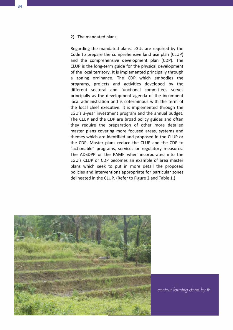
84
84
2)ThemandatedplansRegarding themandatedplans, LGUsare requiredby theCodetopreparethecomprehensive landuseplan(CLUP)and the comprehensive development plan (CDP). TheCLUPisthelong-termguideforthephysicaldevelopmentofthelocalterritory.Itisimplementedprincipallythrougha zoning ordinance. The CDP which embodies theprograms, projects and activities developed by thedifferent sectoral and functional committees servesprincipally as the development agenda of the incumbentlocal administration and is coterminouswith the termofthe local chief executive. It is implemented through theLGU’s3-year investmentprogramandtheannualbudget.TheCLUPand theCDParebroadpolicyguidesandoftenthey require the preparation of other more detailedmaster plans covering more focused areas, systems andthemeswhichare identifiedandproposedintheCLUPorthe CDP. Master plans reduce the CLUP and the CDP to“actionable” programs, services or regulatory measures.The ADSDPP or the PAMP when incorporated into theLGU’s CLUP or CDP becomes an example of areamasterplans which seek to put in more detail the proposedpoliciesandinterventionsappropriateforparticularzonesdelineatedintheCLUP.(RefertoFigure2andTable1.)
contour farming done by IP
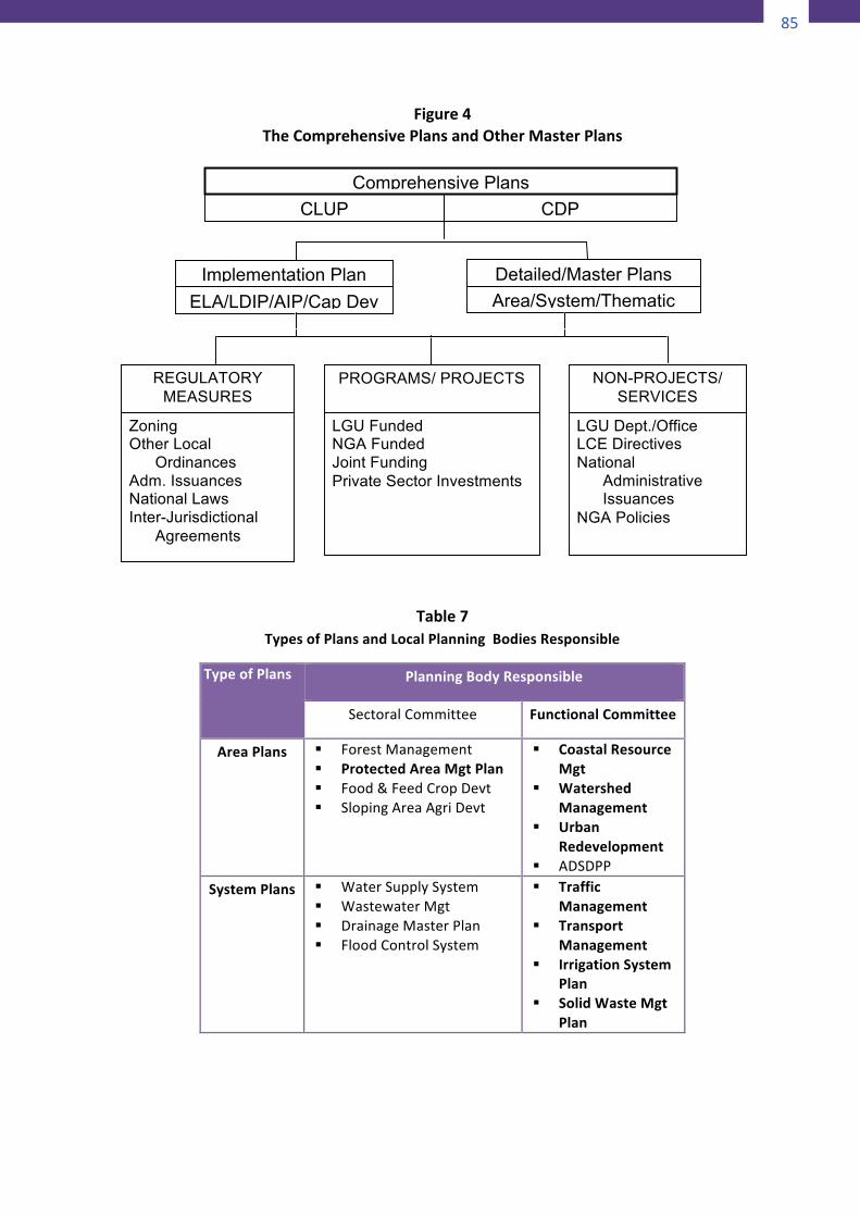
85
84
2)ThemandatedplansRegarding themandatedplans, LGUsare requiredby theCodetopreparethecomprehensive landuseplan(CLUP)and the comprehensive development plan (CDP). TheCLUPisthelong-termguideforthephysicaldevelopmentofthelocalterritory.Itisimplementedprincipallythrougha zoning ordinance. The CDP which embodies theprograms, projects and activities developed by thedifferent sectoral and functional committees servesprincipally as the development agenda of the incumbentlocal administration and is coterminouswith the termofthe local chief executive. It is implemented through theLGU’s3-year investmentprogramandtheannualbudget.TheCLUPand theCDParebroadpolicyguidesandoftenthey require the preparation of other more detailedmaster plans covering more focused areas, systems andthemeswhichare identifiedandproposedintheCLUPorthe CDP. Master plans reduce the CLUP and the CDP to“actionable” programs, services or regulatory measures.The ADSDPP or the PAMP when incorporated into theLGU’s CLUP or CDP becomes an example of areamasterplans which seek to put in more detail the proposedpoliciesandinterventionsappropriateforparticularzonesdelineatedintheCLUP.(RefertoFigure2andTable1.)
contour farming done by IP 85
Figure4TheComprehensivePlansandOtherMasterPlans
Table7TypesofPlansandLocalPlanningBodiesResponsible
TypeofPlans PlanningBodyResponsible
SectoralCommittee FunctionalCommittee
AreaPlans § ForestManagement§ ProtectedAreaMgtPlan§ Food&FeedCropDevt§ SlopingAreaAgriDevt
§ CoastalResourceMgt
§ WatershedManagement
§ UrbanRedevelopment
§ ADSDPPSystemPlans § WaterSupplySystem
§ WastewaterMgt§ DrainageMasterPlan§ FloodControlSystem
§ TrafficManagement
§ TransportManagement
§ IrrigationSystemPlan
§ SolidWasteMgtPlan
Comprehensive Plans CLUP CDP
Implementation Plan ELA/LDIP/AIP/Cap Dev
Detailed/Master Plans Area/System/Thematic
REGULATORY MEASURES
NON-PROJECTS/ SERVICES
PROGRAMS/ PROJECTS
Zoning Other Local
Ordinances Adm. Issuances National Laws Inter-Jurisdictional
Agreements
LGU Funded NGA Funded Joint Funding Private Sector Investments
LGU Dept./Office LCE Directives National
Administrative Issuances
NGA Policies

86
86
ThematicPlans
§ SMEDPlan§ CultureandArts
Promotion§ CPCActionPlan§ FoodSecurityPlan§ Entrepreneurship
Program
§ LocalTourismPlan
§ LocalPovertyActionPlan
§ DisasterRiskMgtPlan
§ GenderandDevtPlan
§ LocalShelterPlan
3)PlanningprocessesRegarding the planning process, the law does notprescribe procedural details. Instead the law admonishesLGUstoundertaketheirplanninginalesstechnocraticandmoreparticipatoryandconsultativemanner.4)AuthorityleversThe fourth component pertains to the principalinstruments for implementing the LGU plans, namely,zoning in the case of the CLUP and investmentprogramminginthecaseoftheCDP.Inadditiontozoningandinvestmentprogramming,thereareothertoolsatthedisposalofLGUs.Someofthemorecommononesincludetaxation, private investment incentives, and co-managementarrangements.
4.3MainstreamingintotheLocalPlanningSystem
Underthe“inprocess”approachtoplanintegration,anyorallof the four components of the local planning system can beused as entry point. Let us see how and what it takes tointegrate the ADSDPP, the PAMP, and their variants,harmonizedmanagementplans,pertainingtoareasofoverlapintoeachcomponentofthelocalplanningsystem.
4.3.1 IntegrationintotheLocalPlanningStructure
The first entry point of mainstreaming is in theorganizationof a sectoralor functional committeeof theLDC.Sectoralcommitteesrepresentthefivedevelopment
87
sectors namely, social, economic, environmental,infrastructure and institutional. Organized as standingcommittees, sectoral committees are coterminous withthetermoftheLDC.Afunctionalcommittee,ontheotherhand, is anadhocworkinggrouporganized toaddressadevelopment issuethat iscrosssectoral incharacter. It isformedwithmembersdrawnfromthepermanentsectoralcommitteesoftheLDC.Otherindividualsandgroupswithrelevant expertise, interests or advocacy arewelcome toparticipate in the activities of these committees. Thesectoralcommitteesareorganizedonceeverythreeyearsalongwith the LDC at the start of a new electoral term.The functional committees are formed any time as theneed arises except for the multi-sectoral bodies createdunder specific laws or local ordinances. From theseworkingbodiesemanatethepolicies,plansandprogramsthat the LDC deliberates and decides on (See Table 2).RepresentativesofICC/IPcommunitiesshouldendeavortobecome members of these working committees if theywantplansandpoliciesfortheirareasofconcerntakenupand given priority. At the very least, members of thePAMB, including the IP representatives in the PAMBshouldmakethemselvesavailableeithertositasmembersof the different committees of the LDC or to serve asresourcepersonstotheLDConmatterspertainingtotheirareasofexpertiseorresponsibility(Sec.107d,RA7160).Conversely, in the case of overlapped regimes theharmonization of the PAMP and ADSDPP requiresinvolvement of the LGU planning officers through theirmembership in the TWG (JMC 2007-01). Even when thePAMP and the ADSDPP are being prepared separately itwouldbeagoodideatohavetheLGUplanningofficersbepartoftheTWGforbothplans.4.3.2 IntegrationintothePlanningProcess
WiththeinvolvementofPAandADrepresentativesintheLDC sectoral and functional committees formulating themandated comprehensive plans and, conversely, theinvolvement of LGU planning officers in the activities of
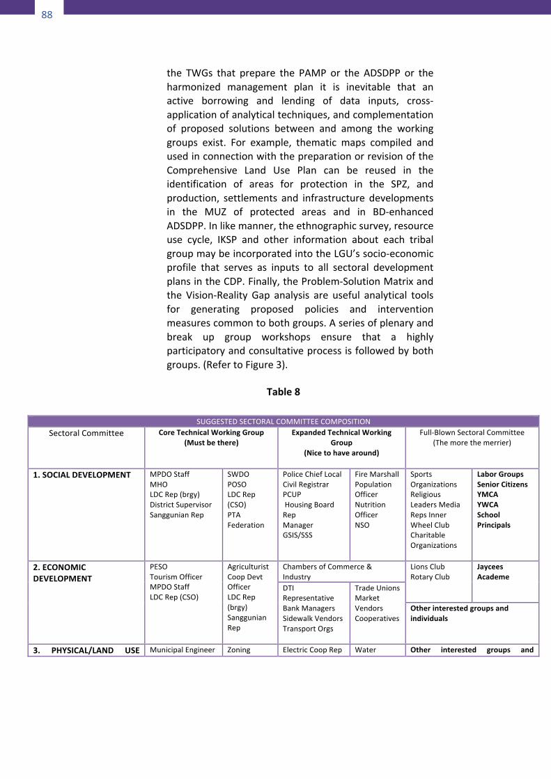
88
88
the TWGs that prepare the PAMP or the ADSDPP or theharmonized management plan it is inevitable that anactive borrowing and lending of data inputs, cross-applicationofanalyticaltechniques,andcomplementationof proposed solutions between and among the workinggroups exist. For example, thematic maps compiled andusedinconnectionwiththepreparationorrevisionoftheComprehensive Land Use Plan can be reused in theidentification of areas for protection in the SPZ, andproduction, settlements and infrastructure developmentsin the MUZ of protected areas and in BD-enhancedADSDPP.Inlikemanner,theethnographicsurvey,resourceuse cycle, IKSP and other information about each tribalgroupmaybeincorporatedintotheLGU’ssocio-economicprofile that serves as inputs to all sectoral developmentplansintheCDP.Finally,theProblem-SolutionMatrixandthe Vision-Reality Gap analysis are useful analytical toolsfor generating proposed policies and interventionmeasurescommontobothgroups.Aseriesofplenaryandbreak up group workshops ensure that a highlyparticipatoryandconsultativeprocessisfollowedbybothgroups.(RefertoFigure3).
Table8
SUGGESTEDSECTORALCOMMITTEECOMPOSITION
SectoralCommittee CoreTechnicalWorkingGroup(Mustbethere)
ExpandedTechnicalWorkingGroup
(Nicetohavearound)
Full-BlownSectoralCommittee(Themorethemerrier)
1.SOCIALDEVELOPMENT MPDOStaffMHOLDCRep(brgy)DistrictSupervisorSanggunianRep
SWDOPOSOLDCRep(CSO)PTAFederation
PoliceChiefLocalCivilRegistrarPCUPHousingBoardRepManagerGSIS/SSS
FireMarshallPopulationOfficerNutritionOfficerNSO
SportsOrganizationsReligiousLeadersMediaRepsInnerWheelClubCharitableOrganizations
LaborGroupsSeniorCitizensYMCAYWCASchoolPrincipals
2.ECONOMICDEVELOPMENT
PESOTourismOfficerMPDOStaffLDCRep(CSO)
AgriculturistCoopDevtOfficerLDCRep(brgy)SanggunianRep
ChambersofCommerce&Industry
LionsClubRotaryClub
JayceesAcademe
DTIRepresentativeBankManagersSidewalkVendorsTransportOrgs
TradeUnionsMarketVendorsCooperatives
Otherinterestedgroupsandindividuals
3. PHYSICAL/LAND USE MunicipalEngineer Zoning ElectricCoopRep Water Other interested groups and
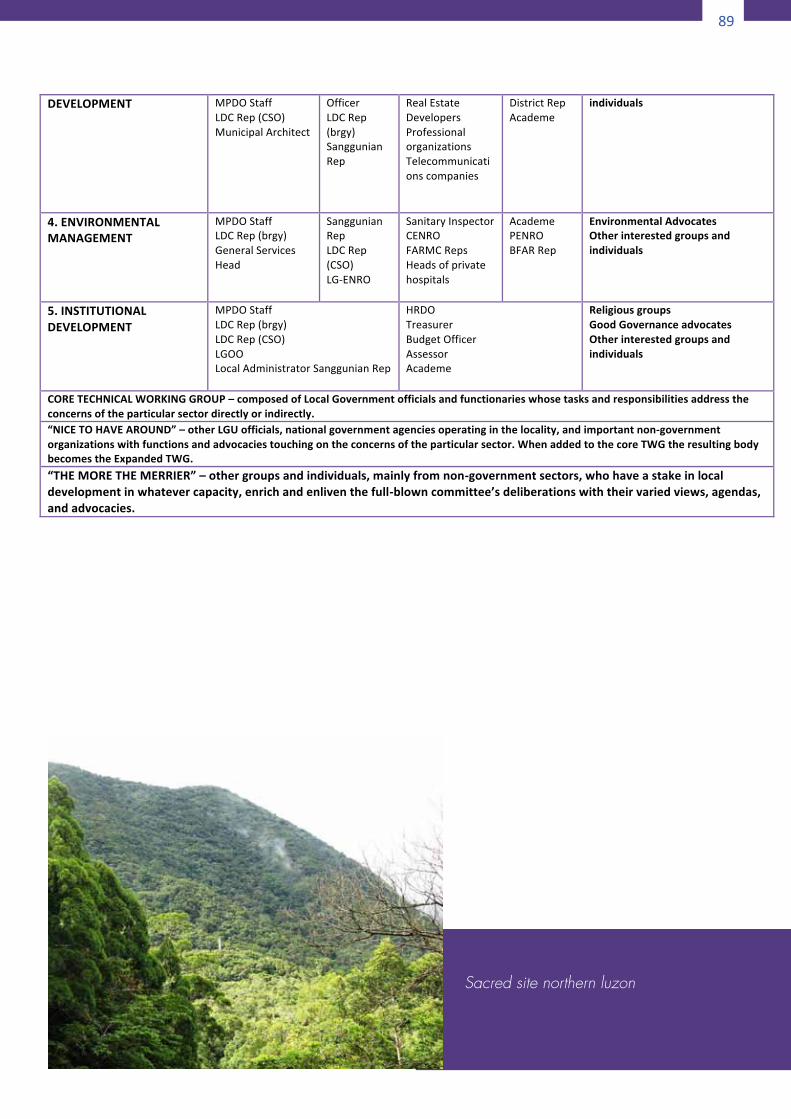
89
88
the TWGs that prepare the PAMP or the ADSDPP or theharmonized management plan it is inevitable that anactive borrowing and lending of data inputs, cross-applicationofanalyticaltechniques,andcomplementationof proposed solutions between and among the workinggroups exist. For example, thematic maps compiled andusedinconnectionwiththepreparationorrevisionoftheComprehensive Land Use Plan can be reused in theidentification of areas for protection in the SPZ, andproduction, settlements and infrastructure developmentsin the MUZ of protected areas and in BD-enhancedADSDPP.Inlikemanner,theethnographicsurvey,resourceuse cycle, IKSP and other information about each tribalgroupmaybeincorporatedintotheLGU’ssocio-economicprofile that serves as inputs to all sectoral developmentplansintheCDP.Finally,theProblem-SolutionMatrixandthe Vision-Reality Gap analysis are useful analytical toolsfor generating proposed policies and interventionmeasurescommontobothgroups.Aseriesofplenaryandbreak up group workshops ensure that a highlyparticipatoryandconsultativeprocessisfollowedbybothgroups.(RefertoFigure3).
Table8
SUGGESTEDSECTORALCOMMITTEECOMPOSITION
SectoralCommittee CoreTechnicalWorkingGroup(Mustbethere)
ExpandedTechnicalWorkingGroup
(Nicetohavearound)
Full-BlownSectoralCommittee(Themorethemerrier)
1.SOCIALDEVELOPMENT MPDOStaffMHOLDCRep(brgy)DistrictSupervisorSanggunianRep
SWDOPOSOLDCRep(CSO)PTAFederation
PoliceChiefLocalCivilRegistrarPCUPHousingBoardRepManagerGSIS/SSS
FireMarshallPopulationOfficerNutritionOfficerNSO
SportsOrganizationsReligiousLeadersMediaRepsInnerWheelClubCharitableOrganizations
LaborGroupsSeniorCitizensYMCAYWCASchoolPrincipals
2.ECONOMICDEVELOPMENT
PESOTourismOfficerMPDOStaffLDCRep(CSO)
AgriculturistCoopDevtOfficerLDCRep(brgy)SanggunianRep
ChambersofCommerce&Industry
LionsClubRotaryClub
JayceesAcademe
DTIRepresentativeBankManagersSidewalkVendorsTransportOrgs
TradeUnionsMarketVendorsCooperatives
Otherinterestedgroupsandindividuals
3. PHYSICAL/LAND USE MunicipalEngineer Zoning ElectricCoopRep Water Other interested groups and
89
DEVELOPMENT MPDOStaff LDCRep(CSO) MunicipalArchitect
OfficerLDCRep(brgy)SanggunianRep
RealEstateDevelopersProfessionalorganizationsTelecommunicationscompanies
DistrictRepAcademe
individuals
4.ENVIRONMENTALMANAGEMENT
MPDOStaff LDCRep(brgy) GeneralServicesHead
SanggunianRepLDCRep(CSO)LG-ENRO
SanitaryInspectorCENROFARMCRepsHeadsofprivatehospitals
AcademePENROBFARRep
EnvironmentalAdvocatesOtherinterestedgroupsandindividuals
5.INSTITUTIONALDEVELOPMENT
MPDOStaffLDCRep(brgy)LDCRep(CSO)LGOOLocalAdministratorSanggunianRep
HRDOTreasurerBudgetOfficerAssessorAcademe
ReligiousgroupsGoodGovernanceadvocatesOtherinterestedgroupsandindividuals
CORETECHNICALWORKINGGROUP–composedofLocalGovernmentofficialsandfunctionarieswhosetasksandresponsibilitiesaddresstheconcernsoftheparticularsectordirectlyorindirectly.“NICETOHAVEAROUND”–otherLGUofficials,nationalgovernmentagenciesoperatinginthelocality,andimportantnon-governmentorganizationswithfunctionsandadvocaciestouchingontheconcernsoftheparticularsector.WhenaddedtothecoreTWGtheresultingbodybecomestheExpandedTWG.“THEMORETHEMERRIER”–othergroupsandindividuals,mainlyfromnon-governmentsectors,whohaveastakeinlocaldevelopmentinwhatevercapacity,enrichandenliventhefull-blowncommittee’sdeliberationswiththeirvariedviews,agendas,andadvocacies.
Sacred site northern luzon
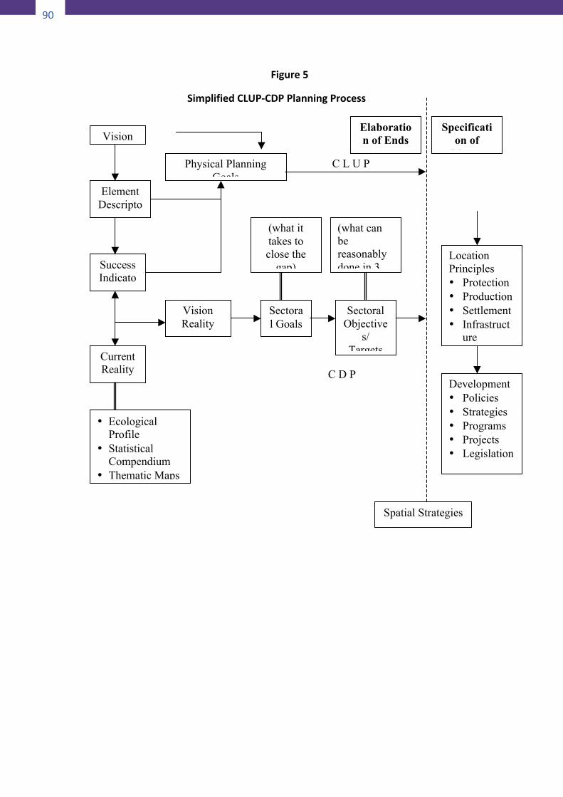
90
90
Figure5
SimplifiedCLUP-CDPPlanningProcess
Spatial Strategies
Vision
Element Descripto
rs
Success Indicato
rs
Current Reality
Physical Planning Goals
• Ecological Profile
• Statistical Compendium
• Thematic Maps
Vision Reality
Gap
Sectoral Goals
(what it takes to close the
gap)
(what can be reasonably done in 3 yrs)
Elaboration of Ends
Specification of
Means
Sectoral Objective
s/ Targets
Location Principles • Protection • Production • Settlement • Infrastruct
ure
Development • Policies • Strategies • Programs • Projects • Legislation
C L U P
C D P
91
4.3.3 IntegrationintotheLGUplans
For all intents and purposes, the ADSDPP and the PAMPareareamasterplans thatpertain to specificportionsofthe local territory (Referback toTable1).Therefore theyform an integral part of the comprehensive plans of thecity/municipality or of the province. In order to makeexplicit the integration of the contents of the plans theproper starting point is the LGU’s vision statement. It istrue that PAs under NIPAS and ADs are self-governingterritorial units. However, being geographically nestedwithin the territorial jurisdictionof the LGUPAs andADsoughttohavetheirvisionandgoalstatementsconsistentwith if not directly supportive of the concerned LGU’svision. Secondly, themanagement zoning of AD, PA andtheir overlapped areas must be consistent with the fourland use policy areas of the CLUP. Already, there isapparentequivalencebetweentheCLUPlandusepoliciesand the two-zone scheme of NIPAS. Greater efforthowever is still needed towards establishing an ethnicgroup-specific system of equivalence between theircustomary land use classification and terminology andthose of the government. (See Table 3 for an example).Thirdly, proposed policies and actions that seek topromote the socio-economic and cultural well-being ofthehumaninhabitantsofprotectedareas,betheyICCs/IPsor non-tribal migrants, should find their way into thesectoralcomponentsoftheCDPasamatterofrightbeingcitizensofthestate.Theultimatetesttotheintegrationofall plans is seen in the way their proposed policyinterventions are expressed in “actionable” forms thatcanbeprioritizedandimplementedthroughtheuseoftheresourcesandpowersatthedisposaloftheLGU,namely,projects,servicesandregulatorymeasures.
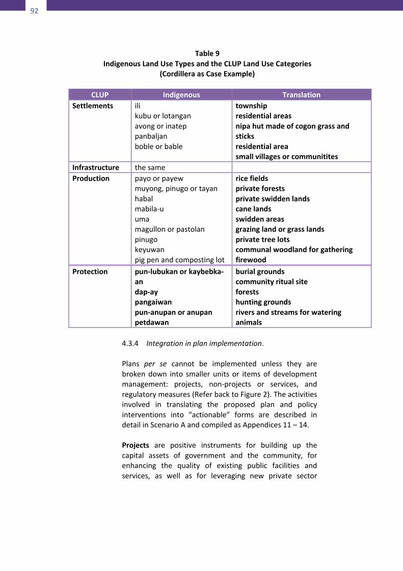
92
92
Table9IndigenousLandUseTypesandtheCLUPLandUseCategories
(CordilleraasCaseExample)
CLUP Indigenous TranslationSettlements ili
kubuorlotanganavongorinateppanbaljanbobleorbable
townshipresidentialareasnipahutmadeofcogongrassandsticksresidentialareasmallvillagesorcommunitites
Infrastructure thesame Production payoorpayew
muyong,pinugoortayanhabalmabila-uumamagullonorpastolanpinugokeyuwanpigpenandcompostinglot
ricefieldsprivateforestsprivateswiddenlandscanelandsswiddenareasgrazinglandorgrasslandsprivatetreelotscommunalwoodlandforgatheringfirewood
Protection pun-lubukanorkaybebka-andap-aypangaiwanpun-anupanoranupanpetdawan
burialgroundscommunityritualsiteforestshuntinggroundsriversandstreamsforwateringanimals
4.3.4 Integrationinplanimplementation.
Plans per se cannot be implemented unless they arebrokendown into smaller units or itemsof developmentmanagement: projects, non-projects or services, andregulatorymeasures(ReferbacktoFigure2).Theactivitiesinvolved in translating the proposed plan and policyinterventions into “actionable” forms are described indetailinScenarioAandcompiledasAppendices11–14.Projects are positive instruments for building up thecapital assets of government and the community, forenhancing the quality of existing public facilities andservices, as well as for leveraging new private sector
93
investments in the locality. Projects are funded throughthe investment or development funds of concernednational agencies, or of the local governmentunit. Someprojects couldbebank rolledby theprivate sector or bycivil society organizations. Implementation of projects isthe responsibility of concerned departments of theexecutive branch, whether by administration or bycontract.ProposedprojectsintheADSDPPandtoalimitedextent the PAMP may be incorporated in the City’sinvestment program and implemented with funds takenfromboththecity’sdevelopmentfundandtheconcernedagencies’ budgets, as authorized by law. To prepareprojects for inclusion in the LGU’s investment program,youhavetoperformthefollowingadditionalactivities:
a. Fromtheoutputoftheactivity“Sortingprojectsbyownership”(Appendix12),selecttheprojectsthatare owned by or under the responsibility of thespecificLGUtowhichyouareintegratingyourplan.
b. IfyouhaveseveralprojectsforfundingbytheLGUyoumightwanttoimproveyourchancesofsuccessby not submitting all of them at the same time.Rememberthattherearemanyothersectorsvyingfor the use of the same scarce resource. So youhavetoprioritize.Forthispurpose,youcanuseanyof the three methods of prioritization given inAppendices16,17and19.
c. Transformeachpriorityprojectintoaprojectbriefand submit this to the LocalDevelopmentCouncilthrough the local planning and developmentcoordinator’soffice.Appendix18willshowyoutheformatandcontentsofaprojectbrief.
Non-projectsorservices,ontheotherhand,areactivitiesand tasks necessary to carry out other proposedinterventions in theplanwhichneednotbedevelopedasfull-blownprojects.Someofthesetasksmayalreadyformpart of the regular functions, or are an additional workloadofexistingdepartmentsoroffices.Stillsomeoftheseactivitiesmayrequirethecreationofnewexecutivebodiesaltogether. Funding for such services is covered by themaintenance and other operating expenditures (MOOE)component of the concerned offices’ or departments’budgets. To the extent that these needed services
94
94
representanaddedpressureonthecurrentresourcesofaparticularoffice it should justify requests for increases inthatoffice’sbudget allocation. In the specific caseof theharmonized PAMP andADSDPP, the needed serviceswillbecarriedoutmainlythroughtheLocalEnvironmentandNaturalResourcesOffice,withtheassistanceandsupportof all other relevantofficesanddepartmentsof the localgovernmentaswellasfieldofficesofnationalgovernmentagenciesoperatinginthelocality.Theprocessofpreparingnon-projects for inclusion in the tasks and functions ofparticular offices, departments and agencies is describedinAppendix13.Regulatorymeasures are also a necessary instrument ofmanagement in that theyseektopreventor limitcertainsocially undesirable actions and behaviours that tend tonullify or neutralize the benefits that would otherwiseaccrue from the positive effect of projects and services.Regulatory measures that fall beyond the prescribedpowers of the local government are enacted by theNational Legislature or Congress. This is the obviousfunction of the Congressman who is represented in thedevelopment councils of all levels of local governments.Needed regulatory measures that are within the LGU’sauthority are enacted by the Sangguniang Bayan/Panlungsod/Panlalawigan and are enforced by theexecutivebranch.Someregulatorymeasuresmayalsobepromulgated through administrative or executive ordersby the Local Chief Executive. In the particular case ofnecessaryregulationstoimplementtheharmonizedPAMPandenhancedADSDPP, theAD/PAzoning schemeshouldbe integrated into the local zoning ordinance. This willenabletheLGUtoexerciseitsauthoritytodeclaretheSPZas “no-build zones” or zones with varying degrees ofrestrictions to human settlements and productionactivities as the case may be in order to maintain theintegrityof thePAand theAD.Other specific regulationsto reinforce the authority of the PAMP/PASu or of theCouncil of Elders/Leaderswill be enacted through single-subject ordinances or through executive orders as theneed arises. Appendix 14 will show you how to processyour proposed legislation for lobbying before the properlegislativebodiesconcerned.
4Integrating the BD-Enhanced ADSDPP and the Harmonized PAMP and ADSDPP in Local Government Planning
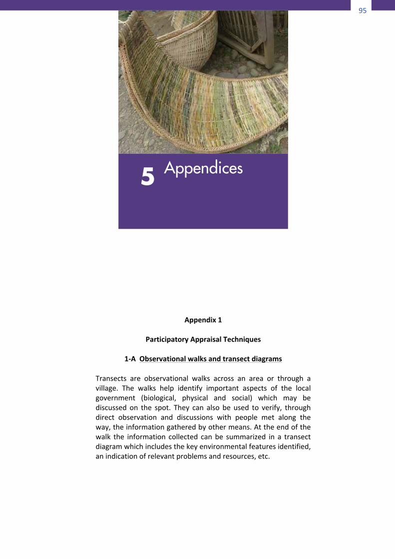
95
94
representanaddedpressureonthecurrentresourcesofaparticularoffice it should justify requests for increases inthatoffice’sbudget allocation. In the specific caseof theharmonized PAMP andADSDPP, the needed serviceswillbecarriedoutmainlythroughtheLocalEnvironmentandNaturalResourcesOffice,withtheassistanceandsupportof all other relevantofficesanddepartmentsof the localgovernmentaswellasfieldofficesofnationalgovernmentagenciesoperatinginthelocality.Theprocessofpreparingnon-projects for inclusion in the tasks and functions ofparticular offices, departments and agencies is describedinAppendix13.Regulatorymeasures are also a necessary instrument ofmanagement in that theyseektopreventor limitcertainsocially undesirable actions and behaviours that tend tonullify or neutralize the benefits that would otherwiseaccrue from the positive effect of projects and services.Regulatory measures that fall beyond the prescribedpowers of the local government are enacted by theNational Legislature or Congress. This is the obviousfunction of the Congressman who is represented in thedevelopment councils of all levels of local governments.Needed regulatory measures that are within the LGU’sauthority are enacted by the Sangguniang Bayan/Panlungsod/Panlalawigan and are enforced by theexecutivebranch.Someregulatorymeasuresmayalsobepromulgated through administrative or executive ordersby the Local Chief Executive. In the particular case ofnecessaryregulationstoimplementtheharmonizedPAMPandenhancedADSDPP, theAD/PAzoning schemeshouldbe integrated into the local zoning ordinance. This willenabletheLGUtoexerciseitsauthoritytodeclaretheSPZas “no-build zones” or zones with varying degrees ofrestrictions to human settlements and productionactivities as the case may be in order to maintain theintegrityof thePAand theAD.Other specific regulationsto reinforce the authority of the PAMP/PASu or of theCouncil of Elders/Leaderswill be enacted through single-subject ordinances or through executive orders as theneed arises. Appendix 14 will show you how to processyour proposed legislation for lobbying before the properlegislativebodiesconcerned.
95
PartV
APPENDICES
Appendix1
ParticipatoryAppraisalTechniques
1-AObservationalwalksandtransectdiagrams
Transects are observational walks across an area or through avillage. The walks help identify important aspects of the localgovernment (biological, physical and social) which may bediscussed on the spot. They can also be used to verify, throughdirect observation and discussions with people met along theway,theinformationgatheredbyothermeans.Attheendofthewalk the information collected can be summarized in a transectdiagramwhichincludesthekeyenvironmentalfeaturesidentified,anindicationofrelevantproblemsandresources,etc.
5 Appendices
96
96
PurposeTherearetwobroadcategoriesoftransects:socialandland-use.Theformercanprovideinformationonhousingdensityandtypes,infrastructures and amenities, cultural and economic activities,etc.Thelatterfocusesonenvironmentalandagriculturalfeaturessuchascultivatedland,forests,hillareas,typesofsoilandcrops,andevidenceofenvironmentaldegradation.Thetwocanalsobecombined.Stepsinusingthetool
• Decidewhichissuestofocusonandwhatinformationneedsto
begathered.• Identify local people to participate in thewalk and explain to
themthepurposeof theexercise (threeto fivepeoplewillbeenough to get a cross-section of views while keeping thediscussionsfocused).
• During the walk, take notes on relevant features. Seekclarificationfrompeoplemetalongtheway.Discussproblemsandopportunities.
• After the walk discuss the notes with the participants andtogetherpreparea transectdiagramof thearea covered.Thenotesanddiagramcanbeusedinfeedbackmeetingswiththecommunityatlarge.
1-BLand-usemapping
Land-usemappingcanbealengthyprocesswithmultiplebenefitsforcommunityorganizingandconflictresolution(Poole,1995).Itcanalsobeashortexerciseasdescribedhere.Asashortexercise,itconsistsofrepresentingthegeographicaldistributionofspecificfeatures(environmental,demographic,socialandeconomic) inaparticular territory as perceived by community members.Participantsareaskedtodrawtheirownmap(onalargesheetofpaper,orontheground),ortoplotfeaturesonapurchasedmapor aerial photo. A variety of symbols (e.g. different types ofvegetation,alphabetical lettersor icons)canbeused forspecificfeatures. If the map is drawn on the ground, it can bephotographedtokeepforfuturereference.Purpose
97
Land-usemappingisespeciallyusefulforprovidingasnapshotofthelocalsituation,includingpropertyboundaries,thelocationofkey resources, features of particular importance to thecommunity, etc. Themap can be a valuable resource for futureimpactassessmentandmonitoringexercises.Asasnapshotoftheland-uses at a particular point in time, it is a source of baselinedata.Stepsinusingthetool
• Inacommunityorfocusgroupmeeting,explainthepurposeof
theexercisetoparticipants.• Askthemtodecideonthesymbolstobeusedforthedifferent
featurestobeidentified.• Ask a participant to be responsible for drawing or plotting
symbolsaccordingtothesuggestionsoftheothers,orhavetheparticipantsconstructthemaptogetherasagroup.Attimesitmay be useful to have a drawing alreadymade (e.g. to delistareas in the forest where different communities collectproducts).
• Promotewideparticipationby posing questions to individualsas needed. Encourage the group to discuss differentperceptionsandtoreachagreementsonconflictpoints.
• Once the map is finalized, it can serve as the basis foridentifying problems, resources and opportunities for action,fordevelopingindicatorsforimpactassessment,trendanalysis,gender analysis, etc. It can also be useful as a baseline tomonitorchangerovertime.
1-CSeasonalcalendars
Seasonal calendars are drawing or series of symbols illustratingthe seasonal changes in various phenomena of environmentalnature(suchasrainfall)orsocialnature(suchaslabordemandorhouseholdincome).PurposeThecalendarsgenerateinformationonseasonalvariationsinlocalproblems,resources,constraintsandopportunities.For instance,they can explore the use and reliance on various resources, thetimeswhen the communityor specific groupsare fullyoccupied(andthereforeconstrained inthecontributionstheycanoffertothe conservation initiative), drought or flood seasons, hungry
98
98
periods, cultural events, and so on. Calendars will differdependingon theoccupationsof thedifferent stakeholders. Forthis reason it may be best to do this exercise separately withdifferentinterestgroups.Stepstousingthistool
• Within a focus or community group, begin with a general
discussion on the activities undertaken in the communitythroughouttheyear.Thishelpstofocusthegrouponthetaskin hand. Make a list of all the issues/activities mentioned sotheyarenotforgottenwhentheparticipantsstarttoconstructtheircalendar.
• Decidetheappropriateformattouse;calendarscanbedrawninavarietyofways.Theformatandthesymbolsforthevariousitemsandactivitiesshouldbeselectedbytheparticipants.Onemethodwhichcouldbesuitable for literatecommunities is tousealargesheetofpaperwiththemonthsorseasonswrittenalongthetopandtheactivitiesundertakenlisteddownononeside. The participants then fill in the matrix by putting ticksunderthemonthsinwhicheachspecificactivityisundertaken.For illiterate people, symbols can be used to represent themonths and activities. For instance, different lengths of stickscanbeusedtosignifythedifferentamountsofrainfall,ortheavailabilityofgameintheforest.Anothermethodistodrawalarge circle with symbols representing the different monthsaround the outside. The circle can then be divided intosegments with symbols for different activities placed insideeachofthesegments.
• Once one or more calendars have been drawn, discuss theresults. For information on labor demands, ask the group toestimate the proportion of time each spends on the variousactivities.Theseproportionscanthenbeshowningraphicformon thecalendar (e.g.portionsoragraph squareorofa circlesegment).
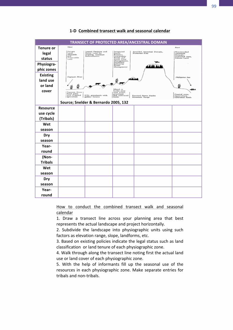
99
98
periods, cultural events, and so on. Calendars will differdependingon theoccupationsof thedifferent stakeholders. Forthis reason it may be best to do this exercise separately withdifferentinterestgroups.Stepstousingthistool
• Within a focus or community group, begin with a general
discussion on the activities undertaken in the communitythroughouttheyear.Thishelpstofocusthegrouponthetaskin hand. Make a list of all the issues/activities mentioned sotheyarenotforgottenwhentheparticipantsstarttoconstructtheircalendar.
• Decidetheappropriateformattouse;calendarscanbedrawninavarietyofways.Theformatandthesymbolsforthevariousitemsandactivitiesshouldbeselectedbytheparticipants.Onemethodwhichcouldbesuitable for literatecommunities is tousealargesheetofpaperwiththemonthsorseasonswrittenalongthetopandtheactivitiesundertakenlisteddownononeside. The participants then fill in the matrix by putting ticksunderthemonthsinwhicheachspecificactivityisundertaken.For illiterate people, symbols can be used to represent themonths and activities. For instance, different lengths of stickscanbeusedtosignifythedifferentamountsofrainfall,ortheavailabilityofgameintheforest.Anothermethodistodrawalarge circle with symbols representing the different monthsaround the outside. The circle can then be divided intosegments with symbols for different activities placed insideeachofthesegments.
• Once one or more calendars have been drawn, discuss theresults. For information on labor demands, ask the group toestimate the proportion of time each spends on the variousactivities.Theseproportionscanthenbeshowningraphicformon thecalendar (e.g.portionsoragraph squareorofa circlesegment).
99
1-DCombinedtransectwalkandseasonalcalendar
How to conduct the combined transect walk and seasonalcalendar1. Draw a transect line across your planning area that bestrepresentstheactuallandscapeandprojecthorizontally.2. Subdivide the landscape into physiographic units using suchfactorsaselevationrange,slope,landforms,etc.3.Basedonexistingpoliciesindicatethelegalstatussuchaslandclassificationorlandtenureofeachphysiographiczone.4.Walkthroughalongthetransectlinenotingfirsttheactuallanduseorlandcoverofeachphysiographiczone.5. With the help of informants fill up the seasonal use of theresources ineachphysiographic zone.Makeseparateentries fortribalsandnon-tribals.
TRANSECTOFPROTECTEDAREA/ANCESTRALDOMAINTenureor
legalstatus
Source;Snelder&Bernardo2005,132
Physiogra-phiczonesExistinglanduseorlandcover
Resourceusecycle(Tribals)
Wetseason
Dryseason
Year-round
(Non-Tribals
Wetseason
Dryseason
Year-round
100
100
6.Analyze theoutputbynoting inconsistenciesatseveral levels,e.g.betweenlegalstatusandactuallanduse;betweenactuallanduseandseasonalusebytribals;betweenseasonalresourceusebytribalsandnon-tribals,etc.
1-EProblemandsolutionmapping
Problemandsolutionmappingisundertakeninagroupsituationusingasimplemapoftherelevantfeaturesoranaerialphotoofthearea.Peopleareaskedtomarkonthemapwheretheythinkthere are problems and how they think those problems can besolved.Ifproblemshavebeenidentifiedintheassessmentstage,then people would just be asked to contribute their ideas forsolvingtheproblem.Depending on the problem, theymight, for example, draw suchthingsasanewirrigationcanal,anareaforforestregeneration,afence to control wild animals, a road realignment, etc. In othercasestheymaysimplydrawsomezoningsuggestions,i.e.fortheareas where collection of wild resources is allowed, for areaswherehousingshouldbebanned,andsoon.PurposeProblem and solution mapping enables all participants tocontribute their ideas and suggestions. By drawing those on acommunal plan, they manage to make them visible to all andusuallyfindawaytointegratethem.Stepsinusingthetool• Explainthesituationthathastobedealtwith(e.g.pollutionof
a coastal area, landerosion,depletionof a species) in simpleand,ifpossible,non-judgmentalterms.
• Explain that the point of the exercise is to find out togetherwhat canbedone to respond to theproblemand stress thateveryonemustbegivenaturnatrecordingtheir ideasonthemaporphoto.
• There should be one map or photo for every 10-15 peoplepresentwhoareaskedtoworkasagroup.
• Handoutcoloredpenstoeachofthegroupsandaskthemtodiscuss theproblemanddrawpossible solutionson themap.Be available to help identify areas/features on the map, ifrequired.
101
• Onceeveryonehashadanopportunitytomarktheirviewsonthemap,encouragethemtolookatthemapsfromtheothergroups(ifthereareany)andcompareanddiscussthedifferentsolutions.
• Ask the group to write their suggestions on a large sheet ofpaper which everyone can see and to present them to theothers. Get people to discuss how effective each proposedsolutionwouldbeandhowitcouldbeundertaken.
• Facilitate consensus on the actions required to address theproblemoutlinedintheopeningpresentation.
• Get the participants to rank the agreed activities in order ofpriority.
1-FCommunity-basedenvironmentalassessment
Community-based environmental assessment provides acommunityperspectiveonthestateoftheenvironment,priortoor during a conservation initiative, as part of a monitoring orevaluation exercise. A list of environmental aspects or factors isagreed upon by the community. The state of each factor isdetermined by allocating a certain value (e.g. excellent, good,poor,disastered,etc.)ornumbertoit.Itisnottheactualvalueornumberthatisimportantbutthewaythosechangeovertimeasrecordedbyongoingobservations.PurposeCommunity-based environmental assessment provides aframework by which insiders can make observations andjudgementsaboutthestateofcertainenvironmentalfactors.Stepsinusingtheprocess• Inameetingwithconcernedcommunitymembers,discussthe
purposeoftheassessmentandhowitcanbecarriedout.• Decide what is to be measured (e.g. well-being of the
community,well-beingofaparticularnaturalarea)anddefinewhatindicatorswillbeused(e.g.abundanceofspecificspeciesin the area, pollution, soil erosion, migration, morbidity andmortality,wealth,literacy,accesstocleanwater,andsoon).
• Writeupthevaluestobeusedandwhateachrepresents(e.g.5=verygood;1=verybad).
102
102
• Drawupa listofall the itemstobeevaluated. If thegroup issmall(lessthanten)workthroughthelisttogethertoreachaconsensusonwhatvalueshouldbeattributedtoeachitematthe present time. If the group is larger, divide into smallergroups, with each group having the same list of items toevaluate. Then bring the groups together to negotiate acommon listofallocatedvalues.Recordand store the resultsand decidewhen the exercisewill be repeated (e.g. after sixmonthsoroneyear).
• Attheagreedtime,repeattheexerciseofassigningavaluetothe items to be assessed. Discuss the reasons for the valuesattributed and the causes of changes since the previousexercise(ifrelevant).
• Identifytheactionswhichneedtobetakeninresponsetotheanalysisandwhoshouldtakeresponsibilityforeachtask.
1-GHistoricalmapping
Historicalmapping isbasedona seriesofparticipatorymappingexercises aimed at portraying changes in a particular resourceand/orsettlementpatterninthecommunityatdifferentintervalsin its history. Three to four maps are drawn: one showing thesituation which currently exists and one showing the situationwhichexistedatsometimeinthepast(say20yearsago).Othermaps are drawn to showwhat the areawill look like if presenttrends continue and, if appropriate, to showhowpeoplewouldliketheareatolookinthe“idealfuture”(say20yearsfromnow).PurposeHistorical mapping helps to introduce the time dimension inparticipatory environmental appraisal. It also provides visualevidence of changeswhich have occurred over time and in thisway helps to identify causes of environmental degradation. Byprojectingtheresultsoftheseactivitiesintothefuture,theneedforchangesinbehaviourusuallybecomesapparent.Stepsinusingthetool
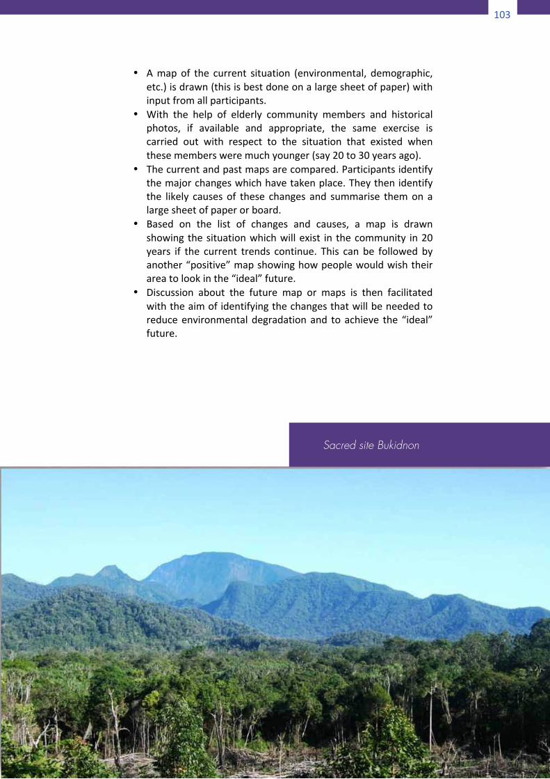
103
102
• Drawupa listofall the itemstobeevaluated. If thegroup issmall(lessthanten)workthroughthelisttogethertoreachaconsensusonwhatvalueshouldbeattributedtoeachitematthe present time. If the group is larger, divide into smallergroups, with each group having the same list of items toevaluate. Then bring the groups together to negotiate acommon listofallocatedvalues.Recordand store the resultsand decidewhen the exercisewill be repeated (e.g. after sixmonthsoroneyear).
• Attheagreedtime,repeattheexerciseofassigningavaluetothe items to be assessed. Discuss the reasons for the valuesattributed and the causes of changes since the previousexercise(ifrelevant).
• Identifytheactionswhichneedtobetakeninresponsetotheanalysisandwhoshouldtakeresponsibilityforeachtask.
1-GHistoricalmapping
Historicalmapping isbasedona seriesofparticipatorymappingexercises aimed at portraying changes in a particular resourceand/orsettlementpatterninthecommunityatdifferentintervalsin its history. Three to four maps are drawn: one showing thesituation which currently exists and one showing the situationwhichexistedatsometimeinthepast(say20yearsago).Othermaps are drawn to showwhat the areawill look like if presenttrends continue and, if appropriate, to showhowpeoplewouldliketheareatolookinthe“idealfuture”(say20yearsfromnow).PurposeHistorical mapping helps to introduce the time dimension inparticipatory environmental appraisal. It also provides visualevidence of changeswhich have occurred over time and in thisway helps to identify causes of environmental degradation. Byprojectingtheresultsoftheseactivitiesintothefuture,theneedforchangesinbehaviourusuallybecomesapparent.Stepsinusingthetool
103
• Amapof the current situation (environmental, demographic,etc.)isdrawn(thisisbestdoneonalargesheetofpaper)withinputfromallparticipants.
• With the help of elderly community members and historicalphotos, if available and appropriate, the same exercise iscarried out with respect to the situation that existed whenthesemembersweremuchyounger(say20to30yearsago).
• Thecurrentandpastmapsarecompared.Participantsidentifythemajorchangeswhichhavetakenplace.Theythenidentifythe likely causes of these changes and summarise themon alargesheetofpaperorboard.
• Based on the list of changes and causes, a map is drawnshowingthesituationwhichwillexist in thecommunity in20years if the current trends continue. This can be followed byanother“positive”mapshowinghowpeoplewouldwishtheirareatolookinthe“ideal”future.
• Discussion about the future map or maps is then facilitatedwiththeaimofidentifyingthechangesthatwillbeneededtoreduceenvironmentaldegradationand toachieve the “ideal”future.
Sacred site Bukidnon
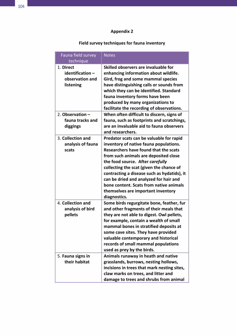
104
104
Appendix2
Fieldsurveytechniquesforfaunainventory
Faunafieldsurveytechnique
Notes
1. Directidentification–observationandlistening
Skilledobserversareinvaluableforenhancinginformationaboutwildlife.Gird,frogandsomemammalspecieshavedistinguishingcallsorsoundsfromwhichtheycanbeidentified.Standardfaunainventoryformshavebeenproducedbymanyorganizationstofacilitatetherecordingofobservations.
2. Observation–faunatracksanddiggings
Whenoftendifficulttodiscern,signsoffauna,suchasfootprintsandscratchings,areaninvaluableaidtofaunaobserversandresearchers.
3. Collectionandanalysisoffaunascats
Predatorscatscanbevaluableforrapidinventoryofnativefaunapopulations.Researchershavefoundthatthescatsfromsuchanimalsaredepositedclosethefoodsource.Aftercarefullycollectingthescat(giventhechanceofcontractingadiseasesuchashydatids),itcanbedriedandanalyzedforhairandbonecontent.Scatsfromnativeanimalsthemselvesareimportantinventorydiagnostics.
4. Collectionandanalysisofbirdpellets
Somebirdsregurgitatebone,feather,furandotherfragmentsoftheirmealsthattheyarenotabletodigest.Owlpellets,forexample,containawealthofsmallmammalbonesinstratifieddepositsatsomecavesites.Theyhaveprovidedvaluablecontemporaryandhistoricalrecordsofsmallmammalpopulationsusedaspreybythebirds.
5. Faunasignsintheirhabitat
Animalsrunawayinheathandnativegrasslands,burrows,nestinghollows,incisionsintreesthatmarknestingsites,clawmarksontrees,andlitteranddamagetotreesandshrubsfromanimal
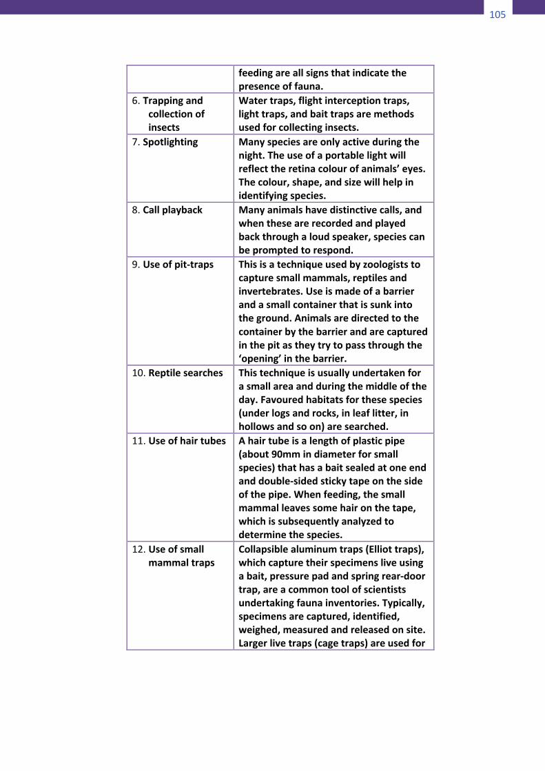
105
104
Appendix2
Fieldsurveytechniquesforfaunainventory
Faunafieldsurveytechnique
Notes
1. Directidentification–observationandlistening
Skilledobserversareinvaluableforenhancinginformationaboutwildlife.Gird,frogandsomemammalspecieshavedistinguishingcallsorsoundsfromwhichtheycanbeidentified.Standardfaunainventoryformshavebeenproducedbymanyorganizationstofacilitatetherecordingofobservations.
2. Observation–faunatracksanddiggings
Whenoftendifficulttodiscern,signsoffauna,suchasfootprintsandscratchings,areaninvaluableaidtofaunaobserversandresearchers.
3. Collectionandanalysisoffaunascats
Predatorscatscanbevaluableforrapidinventoryofnativefaunapopulations.Researchershavefoundthatthescatsfromsuchanimalsaredepositedclosethefoodsource.Aftercarefullycollectingthescat(giventhechanceofcontractingadiseasesuchashydatids),itcanbedriedandanalyzedforhairandbonecontent.Scatsfromnativeanimalsthemselvesareimportantinventorydiagnostics.
4. Collectionandanalysisofbirdpellets
Somebirdsregurgitatebone,feather,furandotherfragmentsoftheirmealsthattheyarenotabletodigest.Owlpellets,forexample,containawealthofsmallmammalbonesinstratifieddepositsatsomecavesites.Theyhaveprovidedvaluablecontemporaryandhistoricalrecordsofsmallmammalpopulationsusedaspreybythebirds.
5. Faunasignsintheirhabitat
Animalsrunawayinheathandnativegrasslands,burrows,nestinghollows,incisionsintreesthatmarknestingsites,clawmarksontrees,andlitteranddamagetotreesandshrubsfromanimal
105
feedingareallsignsthatindicatethepresenceoffauna.
6. Trappingandcollectionofinsects
Watertraps,flightinterceptiontraps,lighttraps,andbaittrapsaremethodsusedforcollectinginsects.
7. Spotlighting Manyspeciesareonlyactiveduringthenight.Theuseofaportablelightwillreflecttheretinacolourofanimals’eyes.Thecolour,shape,andsizewillhelpinidentifyingspecies.
8. Callplayback Manyanimalshavedistinctivecalls,andwhenthesearerecordedandplayedbackthroughaloudspeaker,speciescanbepromptedtorespond.
9. Useofpit-traps Thisisatechniqueusedbyzoologiststocapturesmallmammals,reptilesandinvertebrates.Useismadeofabarrierandasmallcontainerthatissunkintotheground.Animalsaredirectedtothecontainerbythebarrierandarecapturedinthepitastheytrytopassthroughthe‘opening’inthebarrier.
10. Reptilesearches Thistechniqueisusuallyundertakenforasmallareaandduringthemiddleoftheday.Favouredhabitatsforthesespecies(underlogsandrocks,inleaflitter,inhollowsandsoon)aresearched.
11. Useofhairtubes Ahairtubeisalengthofplasticpipe(about90mmindiameterforsmallspecies)thathasabaitsealedatoneendanddouble-sidedstickytapeonthesideofthepipe.Whenfeeding,thesmallmammalleavessomehaironthetape,whichissubsequentlyanalyzedtodeterminethespecies.
12. Useofsmallmammaltraps
Collapsiblealuminumtraps(Elliottraps),whichcapturetheirspecimensliveusingabait,pressurepadandspringrear-doortrap,areacommontoolofscientistsundertakingfaunainventories.Typically,specimensarecaptured,identified,weighed,measuredandreleasedonsite.Largerlivetraps(cagetraps)areusedfor
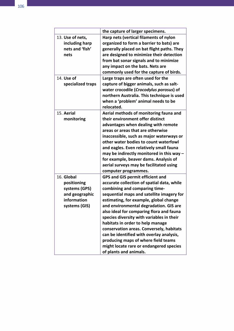
106
106
thecaptureoflargerspecimens.13. Useofnets,
includingharpnetsand‘fish’nets
Harpnets(verticalfilamentsofnylonorganizedtoformabarriertobats)aregenerallyplacedonbatflightpaths.Theyaredesignedtominimizetheirdetectionfrombatsonarsignalsandtominimizeanyimpactonthebats.Netsarecommonlyusedforthecaptureofbirds.
14. Useofspecializedtraps
Largetrapsareoftenusedforthecaptureofbiggeranimals,suchassalt-watercrocodile(Crocodylusporosus)ofnorthernAustralia.Thistechniqueisusedwhena‘problem’animalneedstoberelocated.
15. Aerialmonitoring
Aerialmethodsofmonitoringfaunaandtheirenvironmentofferdistinctadvantageswhendealingwithremoteareasorareasthatareotherwiseinaccessible,suchasmajorwaterwaysorotherwaterbodiestocountwaterfowlandeagles.Evenrelativelysmallfaunamaybeindirectlymonitoredinthisway–forexample,beaverdams.Analysisofaerialsurveysmaybefacilitatedusingcomputerprogrammes.
16. Globalpositioningsystems(GPS)andgeographicinformationsystems(GIS)
GPSandGISpermitefficientandaccuratecollectionofspatialdata,whilecombiningandcomparingtime-sequentialmapsandsatelliteimageryforestimating,forexample,globalchangeandenvironmentaldegradation.GISarealsoidealforcomparingfloraandfaunaspeciesdiversitywithvariablesintheirhabitatsinordertohelpmanageconservationareas.Conversely,habitatscanbeidentifiedwithoverlayanalysis,producingmapsofwherefieldteamsmightlocaterareorendangeredspeciesofplantsandanimals.
107
Appendix3
3-ACriteriaforDeterminingSuitability
forProtectedAreaStatus(UnderNIPAS)
A.NaturalProperties
1. Representativeness: Exemplification of habitat typeswithinthebiographiczones.
2. Naturalness: Intactness of environment from humandevelopment activities, with at least 60% intact forexcellent rating; 50%, good; 40%, fair and below 40%,poor/verypoor.
3. Abundance: Presence and number of individual perspeciesoffloraandfaunainthesite.
4. Diversity:Presenceandnumberofflora,faunainthesite.B.ManagementAttributes
1. Socio-EconomicAcceptability:Attitudeoflocalcommunitytowardsprotectedareamanagement.
2. Accessibility: Access to the area for recreational,educational, scientific, management and livelihoodactivities.
3. Size: Sufficiently in size to allow management andadministrative purposes and compatible uses as aprotectedarea.
4. Importance: Value of area in terms of scientific,educational,recreationalandotherpurposes.
5. Uniqueness: Presence of rare threatened/endangered,indigenous and endemic species or unusualgeological/archeologicalfeatures.
6. Criticalness:Dependencyof important floraand faunaontheareaforcertainlifestagesofentirelifehistories.
7. Threats: Existing/potential habitatdestruction/disturbances from human activities in thearea.
8. Traditional Uses: Cultural importance of the area to theICCincludingpractices,beliefsandtraditions.
3-BTheNatureConservationReviewCriteria
(Green,1996)
108
108
1. Size (extent). Sites should be big enough to ensure that
edgeeffects(e.g.sprays,drainage)donotextendoverthewhole area, and that the right habitats for differentspeciesarepresent,andinsufficientextent.
2. Positioninanecological/geographicalunit.Sitesincludinganumberofdifferentecosystems, and thoseadjacentornear tosites representingotherecosystemsareregardedas more desirable as reserves than those representing asingle ecosystem. The location of a reserve near anotheroneisimportantinreducingitsisolationandbolsteringitsspeciescomplement.Ifalargereservecannotbeacquired,groups of smaller ones in the same locality are a goodalternative, especially if they are linked by habitatcorridors throughwhichspeciesmigrationcanoccur.Thepresence of more than one ecosystem on a site, andespecially of ecotones between ecosystems, also addsconsiderablytospeciesrichness.
3. Diversity. Species andhabitat are verymuch functionsofthe size and location of sites, and big sites with a goodrepresentationof ecosystemsareheld tobedesirable asreservesbecauseofthespeciesrichnesstheyconfer.
4. Rarity. Many protected areas have been establishedprimarily to protect rare species. Rarity of species andhabitats, with diversity and representativeness, havealways been accepted as a primary consideration in theselection of protected areas. Rarity—especially itsextreme, the unique—is a key element in all valuablesystems.
5. Typicalness (representativeness). Protecting the speciesand ecosystems best represented in the country ratherthanthosethatarerare.Ascriteria,rarityandtypicalnesscan clearly be in conflict; the important thing is thegeographicalareaunderconsideration.
6. Fragility. Some species and ecosystems are morevulnerable than others and therefore more deserving ofprotection. They may be vulnerable because of inherentforces of change, such as succession or they may beparticularlythreatenedbyhumanactivities.
7. Naturalness. It is self-explanatory and earns generalsympathy,but isadifficultcriterion toapply inacountrywherenoecosystemsaretrulynatural.
8. Potential value. It recognizes that some modifiedecosystems like woodlands managed as plantations, or
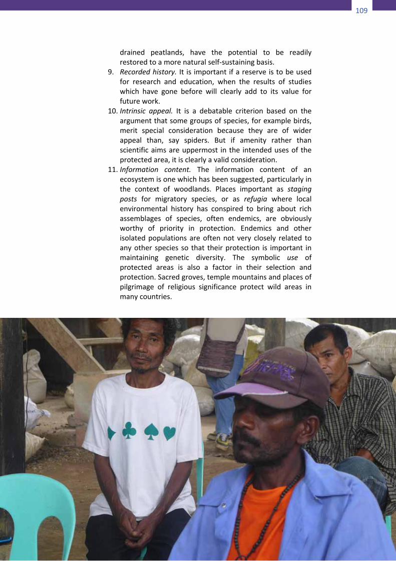
109
108
1. Size (extent). Sites should be big enough to ensure that
edgeeffects(e.g.sprays,drainage)donotextendoverthewhole area, and that the right habitats for differentspeciesarepresent,andinsufficientextent.
2. Positioninanecological/geographicalunit.Sitesincludinganumberofdifferentecosystems, and thoseadjacentornear tosites representingotherecosystemsareregardedas more desirable as reserves than those representing asingle ecosystem. The location of a reserve near anotheroneisimportantinreducingitsisolationandbolsteringitsspeciescomplement.Ifalargereservecannotbeacquired,groups of smaller ones in the same locality are a goodalternative, especially if they are linked by habitatcorridors throughwhichspeciesmigrationcanoccur.Thepresence of more than one ecosystem on a site, andespecially of ecotones between ecosystems, also addsconsiderablytospeciesrichness.
3. Diversity. Species andhabitat are verymuch functionsofthe size and location of sites, and big sites with a goodrepresentationof ecosystemsareheld tobedesirable asreservesbecauseofthespeciesrichnesstheyconfer.
4. Rarity. Many protected areas have been establishedprimarily to protect rare species. Rarity of species andhabitats, with diversity and representativeness, havealways been accepted as a primary consideration in theselection of protected areas. Rarity—especially itsextreme, the unique—is a key element in all valuablesystems.
5. Typicalness (representativeness). Protecting the speciesand ecosystems best represented in the country ratherthanthosethatarerare.Ascriteria,rarityandtypicalnesscan clearly be in conflict; the important thing is thegeographicalareaunderconsideration.
6. Fragility. Some species and ecosystems are morevulnerable than others and therefore more deserving ofprotection. They may be vulnerable because of inherentforces of change, such as succession or they may beparticularlythreatenedbyhumanactivities.
7. Naturalness. It is self-explanatory and earns generalsympathy,but isadifficultcriterion toapply inacountrywherenoecosystemsaretrulynatural.
8. Potential value. It recognizes that some modifiedecosystems like woodlands managed as plantations, or
109
drained peatlands, have the potential to be readilyrestoredtoamorenaturalself-sustainingbasis.
9. Recordedhistory. It is importantifareserveistobeusedfor research and education, when the results of studieswhich have gone before will clearly add to its value forfuturework.
10. Intrinsic appeal. It is a debatable criterion based on theargumentthatsomegroupsofspecies,forexamplebirds,merit special consideration because they are of widerappeal than, say spiders. But if amenity rather thanscientificaimsareuppermost in the intendedusesof theprotectedarea,itisclearlyavalidconsideration.
11. Information content. The information content of anecosystemisonewhichhasbeensuggested,particularlyinthe context of woodlands. Places important as stagingposts for migratory species, or as refugia where localenvironmental history has conspired to bring about richassemblages of species, often endemics, are obviouslyworthy of priority in protection. Endemics and otherisolatedpopulations areoftennot very closely related toanyother species so that theirprotection is important inmaintaining genetic diversity. The symbolic use ofprotected areas is also a factor in their selection andprotection.Sacredgroves,templemountainsandplacesofpilgrimage of religious significance protect wild areas inmanycountries.
110
110
Appendix4
SurveysoftheResidentCommunities
4-AFocusgroupinterviews
Focus group interviews are semi-structured discussions with agroup of people who share a common feature (e.g. women ofreproductiveage,shareholdersinanirrigationsystem,usersofaparticular service, etc.) Participants are chosen by means ofsamplingprocedures (e.g. fromacross-sectionofages,avarietyofland-areaownership,differentresource-users,etc.).Dependingonlocalconditions,afocusgroupcanincludeasfewasfiveandasmanyas15ormoreindividuals.Alistofopen-endedquestionsisusedto focusthediscussiononthe issuesofconcernbut,as fornatural group interviews, follow-up questions can be developedduringtheconversation.PurposeFocus group interviews were developed in market-research todetermine customer’s preferences and expectations. Since the1980’s they have been used increasingly for sociological studiesandinparticipatoryresearch,particularlyresearchtoidentifyanddescribegroupperceptions,attitudesandneeds.Stepsinusingthetool• Identifyalistofkeyquestionstoguidetheinterview.Develop
asystemforanalyzingtheinformationcollected;forexampleamatrix of topics and variables, or just a list of key topics andpossible responses (e.g. negative/positive, concerned/notconcerned)plusaspaceforcomments.
• Identify the groups in the community concerned about thetopicunderinvestigation.
• Decide on the number of focus groups and the number ofparticipantsineachgroup.Inasmallcommunitytwoorthreegroups (e.g. men/women; elders/adults/youth;agriculturalists/herders; wealthy/poor) of five to tenparticipantseach,maybesufficient.
• Conduct a practice (pilot) session with other communitymembers (another community altogether if similarcircumstances exist) to check that the questions are relevant
111
andeasily understoodand that the typeof responses canbesummarizedintheanalysissystemdesignedforthepurpose.
• Before starting each focus group interview, explain thepurposeoftheexercise.Poseyourquestionstothegroupandbe sure that each participant feels comfortable in speaking.Over-talkativeparticipantsshouldbecontrolledandsilentonesstimulated. Limit the duration of the session; a focus groupinterviewshouldlastaboutonehour.
• Since the interviewer also acts as a group facilitator, anotherpersonshouldrecordthediscussionandjotdownthemeaningoftheinterventionsaswellasthemostcharacteristicquotes.Ifthis is not possible, a tape recorder could be used, providedthegroupmembersgivetheirpriorpermission.Taperecordingisparticularlyhelpfulforreviewingtheinformationindetail.
• Carefully review and analyze the interview notes or tapes toextractkeystatements,issuesraisedandpatternsofresponsesin accordance with the analysis framework designed at thebeginning of the process. The framework may need to beamendedtoaccommodateunexpectedresponses.
• Ifpossible,reviewtheinterviewsummarywiththeparticipantsfor them to check that their comments have been recordedandanalyzedcorrectly.
4-BSemi-structuredinterviewswithkeyinformants
Semi-structured interviews involve lists of questions to beaddressedtoknowledgeableindividualsinarelaxedandinformalway. Unlike questionnaires with standardized questions andclosed-ended answers, semi-structured interviews only includegeneral questions. This leaves the interviewer free to rephrasethemasappropriateandtoaddfurtherinquiriessuchas“Who?”“Where?” “When?” “Why?” and “How?” based on therespondent’sanswersandconversationflow.PurposeSemi-structured interviews can be used to obtain specific, in-depth,quantitativeandqualitativeinformationonspecificpointsof interest. Decision-making systems, gender-related issues, useofnaturalresources,householdeconomicsandmanyothertopicscan be effectively explored with this tool. Information can begivenaswellasreceivedduringtheinterview.
112
112
Stepsinusingthistool• Design an interview quide and a summary form of the
responses(similartothoseusedforfocus-groupinterviews).• Identify the key informants to interview. Some selective
identification may be needed to ensure all key perspectivesand/or fields of knowledge are covered. New informants canbeaddedonthebasisoftheresultsoftheearlyinterviews.
• Conductatleastonepracticeinterviewwithothermembersofthe interview team or with other community members tocheckthatthequestionsareclearandinalogicalorder.
• Organizeatimeandplacefortheinterview,convenienttothepersonbeinginterviewed.
• Before the interview commences, inform the person of theextent to which you can ensure confidentiality (e.g. theinformation may be generalized and not attributed to anyparticularindividual).
• Make only brief notes during the interviews, filling out thesummaryformimmediatelyafterwards.Ataperecordercanbeused,providedthepersongivestheirpriorpermission.
• Unexpected information may surface during interviews. Ifmorethanonepersonisinterviewing,theinterviewersshoulddiscuss together on a daily basis any new information orproblems encountered during interviews, as well as thepreliminary results. Adjust the interview guide and summaryform,ifnecessary,inresponsetothesefindings.
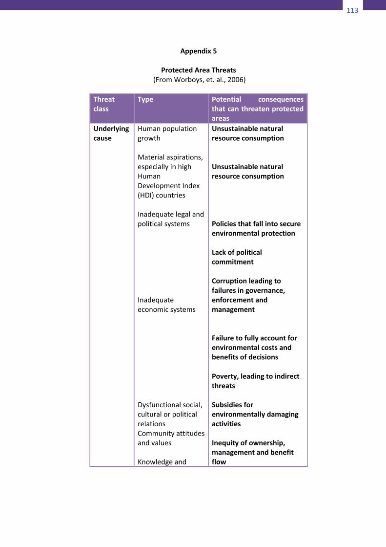
113
112
Stepsinusingthistool• Design an interview quide and a summary form of the
responses(similartothoseusedforfocus-groupinterviews).• Identify the key informants to interview. Some selective
identification may be needed to ensure all key perspectivesand/or fields of knowledge are covered. New informants canbeaddedonthebasisoftheresultsoftheearlyinterviews.
• Conductatleastonepracticeinterviewwithothermembersofthe interview team or with other community members tocheckthatthequestionsareclearandinalogicalorder.
• Organizeatimeandplacefortheinterview,convenienttothepersonbeinginterviewed.
• Before the interview commences, inform the person of theextent to which you can ensure confidentiality (e.g. theinformation may be generalized and not attributed to anyparticularindividual).
• Make only brief notes during the interviews, filling out thesummaryformimmediatelyafterwards.Ataperecordercanbeused,providedthepersongivestheirpriorpermission.
• Unexpected information may surface during interviews. Ifmorethanonepersonisinterviewing,theinterviewersshoulddiscuss together on a daily basis any new information orproblems encountered during interviews, as well as thepreliminary results. Adjust the interview guide and summaryform,ifnecessary,inresponsetothesefindings.
113
Appendix5
ProtectedAreaThreats(FromWorboys,et.al.,2006)
Threatclass
Type Potential consequencesthatcanthreatenprotectedareas
Underlyingcause
HumanpopulationgrowthMaterialaspirations,especiallyinhighHumanDevelopmentIndex(HDI)countriesInadequatelegalandpoliticalsystemsInadequateeconomicsystemsDysfunctionalsocial,culturalorpoliticalrelationsCommunityattitudesandvaluesKnowledgeand
UnsustainablenaturalresourceconsumptionUnsustainablenaturalresourceconsumptionPoliciesthatfallintosecureenvironmentalprotectionLackofpoliticalcommitmentCorruptionleadingtofailuresingovernance,enforcementandmanagementFailuretofullyaccountforenvironmentalcostsandbenefitsofdecisionsPoverty,leadingtoindirectthreatsSubsidiesforenvironmentallydamagingactivitiesInequityofownership,managementandbenefitflow
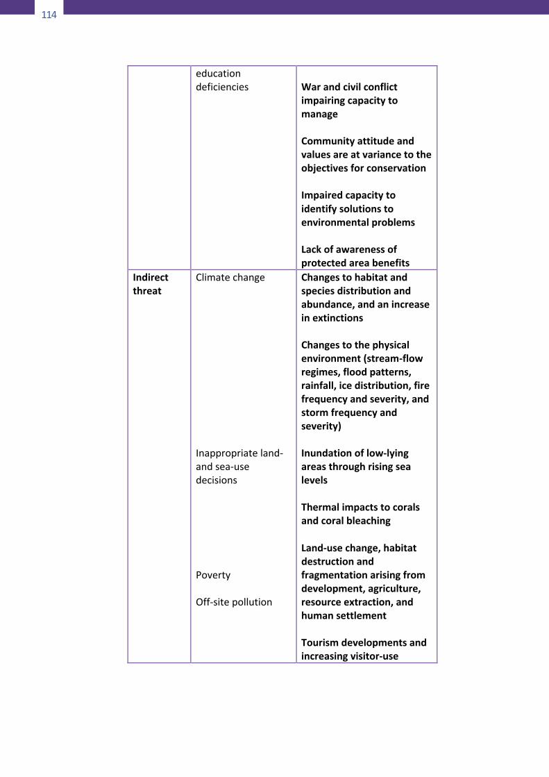
114
114
educationdeficiencies
WarandcivilconflictimpairingcapacitytomanageCommunityattitudeandvaluesareatvariancetotheobjectivesforconservationImpairedcapacitytoidentifysolutionstoenvironmentalproblemsLackofawarenessofprotectedareabenefits
Indirectthreat
ClimatechangeInappropriateland-andsea-usedecisionsPovertyOff-sitepollution
Changestohabitatandspeciesdistributionandabundance,andanincreaseinextinctionsChangestothephysicalenvironment(stream-flowregimes,floodpatterns,rainfall,icedistribution,firefrequencyandseverity,andstormfrequencyandseverity)Inundationoflow-lyingareasthroughrisingsealevelsThermalimpactstocoralsandcoralbleachingLand-usechange,habitatdestructionandfragmentationarisingfromdevelopment,agriculture,resourceextraction,andhumansettlementTourismdevelopmentsandincreasingvisitor-use
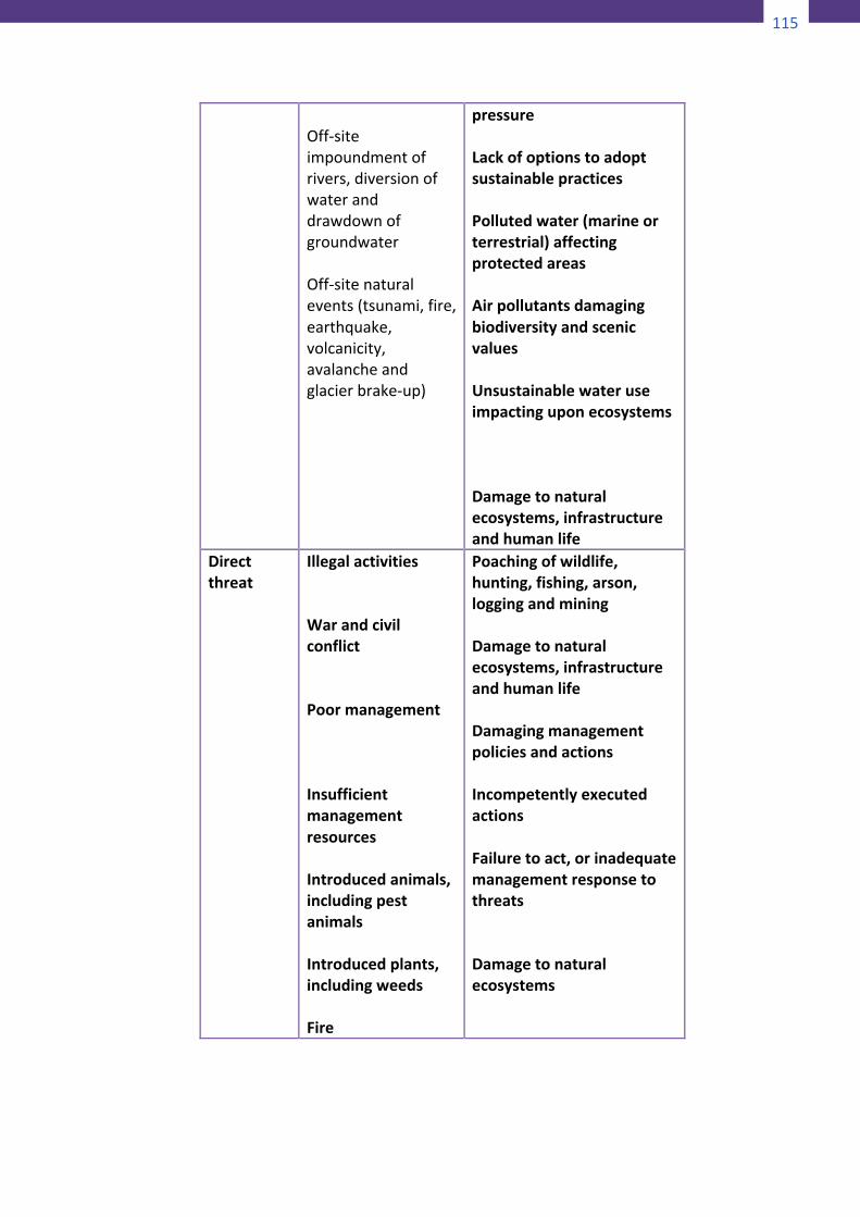
115
114
educationdeficiencies
WarandcivilconflictimpairingcapacitytomanageCommunityattitudeandvaluesareatvariancetotheobjectivesforconservationImpairedcapacitytoidentifysolutionstoenvironmentalproblemsLackofawarenessofprotectedareabenefits
Indirectthreat
ClimatechangeInappropriateland-andsea-usedecisionsPovertyOff-sitepollution
Changestohabitatandspeciesdistributionandabundance,andanincreaseinextinctionsChangestothephysicalenvironment(stream-flowregimes,floodpatterns,rainfall,icedistribution,firefrequencyandseverity,andstormfrequencyandseverity)Inundationoflow-lyingareasthroughrisingsealevelsThermalimpactstocoralsandcoralbleachingLand-usechange,habitatdestructionandfragmentationarisingfromdevelopment,agriculture,resourceextraction,andhumansettlementTourismdevelopmentsandincreasingvisitor-use
115
Off-siteimpoundmentofrivers,diversionofwateranddrawdownofgroundwaterOff-sitenaturalevents(tsunami,fire,earthquake,volcanicity,avalancheandglacierbrake-up)
pressureLackofoptionstoadoptsustainablepracticesPollutedwater(marineorterrestrial)affectingprotectedareasAirpollutantsdamagingbiodiversityandscenicvaluesUnsustainablewateruseimpactinguponecosystemsDamagetonaturalecosystems,infrastructureandhumanlife
Directthreat
IllegalactivitiesWarandcivilconflictPoormanagementInsufficientmanagementresourcesIntroducedanimals,includingpestanimalsIntroducedplants,includingweedsFire
Poachingofwildlife,hunting,fishing,arson,loggingandminingDamagetonaturalecosystems,infrastructureandhumanlifeDamagingmanagementpoliciesandactionsIncompetentlyexecutedactionsFailuretoact,orinadequatemanagementresponsetothreatsDamagetonaturalecosystems
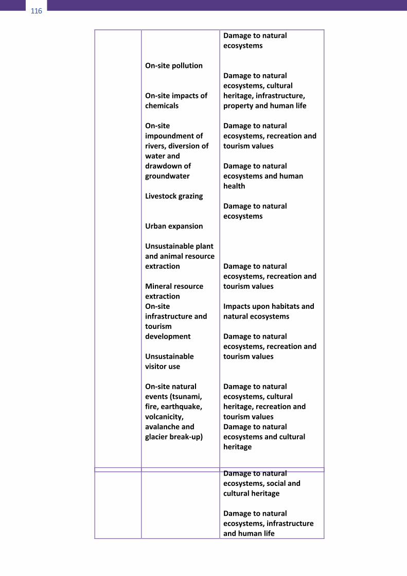
116
116
On-sitepollutionOn-siteimpactsofchemicalsOn-siteimpoundmentofrivers,diversionofwateranddrawdownofgroundwaterLivestockgrazingUrbanexpansionUnsustainableplantandanimalresourceextractionMineralresourceextractionOn-siteinfrastructureandtourismdevelopmentUnsustainablevisitoruseOn-sitenaturalevents(tsunami,fire,earthquake,volcanicity,avalancheandglacierbreak-up)
DamagetonaturalecosystemsDamagetonaturalecosystems,culturalheritage,infrastructure,propertyandhumanlifeDamagetonaturalecosystems,recreationandtourismvaluesDamagetonaturalecosystemsandhumanhealthDamagetonaturalecosystemsDamagetonaturalecosystems,recreationandtourismvaluesImpactsuponhabitatsandnaturalecosystemsDamagetonaturalecosystems,recreationandtourismvaluesDamagetonaturalecosystems,culturalheritage,recreationandtourismvaluesDamagetonaturalecosystemsandculturalheritage
117
Damagetonaturalecosystems,socialandculturalheritageDamagetonaturalecosystems,infrastructureandhumanlife
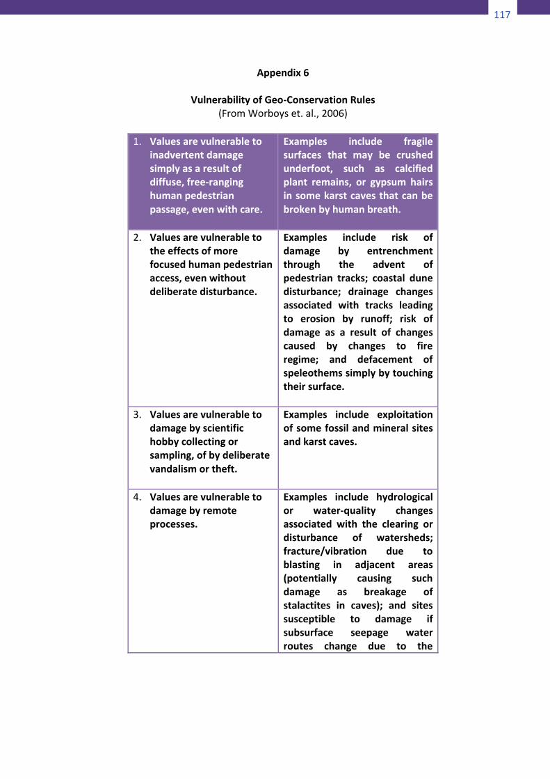
117
116
On-sitepollutionOn-siteimpactsofchemicalsOn-siteimpoundmentofrivers,diversionofwateranddrawdownofgroundwaterLivestockgrazingUrbanexpansionUnsustainableplantandanimalresourceextractionMineralresourceextractionOn-siteinfrastructureandtourismdevelopmentUnsustainablevisitoruseOn-sitenaturalevents(tsunami,fire,earthquake,volcanicity,avalancheandglacierbreak-up)
DamagetonaturalecosystemsDamagetonaturalecosystems,culturalheritage,infrastructure,propertyandhumanlifeDamagetonaturalecosystems,recreationandtourismvaluesDamagetonaturalecosystemsandhumanhealthDamagetonaturalecosystemsDamagetonaturalecosystems,recreationandtourismvaluesImpactsuponhabitatsandnaturalecosystemsDamagetonaturalecosystems,recreationandtourismvaluesDamagetonaturalecosystems,culturalheritage,recreationandtourismvaluesDamagetonaturalecosystemsandculturalheritage
117
Damagetonaturalecosystems,socialandculturalheritageDamagetonaturalecosystems,infrastructureandhumanlife
118
Appendix6
VulnerabilityofGeo-ConservationRules(FromWorboyset.al.,2006)
1. Valuesarevulnerableto
inadvertentdamagesimplyasaresultofdiffuse,free-ranginghumanpedestrianpassage,evenwithcare.
Examples include fragilesurfaces that may be crushedunderfoot, such as calcifiedplant remains, or gypsum hairsinsomekarstcavesthatcanbebrokenbyhumanbreath.
2. Valuesarevulnerabletotheeffectsofmorefocusedhumanpedestrianaccess,evenwithoutdeliberatedisturbance.
Examples include risk ofdamage by entrenchmentthrough the advent ofpedestrian tracks; coastal dunedisturbance; drainage changesassociated with tracks leadingto erosion by runoff; risk ofdamage as a result of changescaused by changes to fireregime; and defacement ofspeleothemssimplybytouchingtheirsurface.
3. Valuesarevulnerabletodamagebyscientifichobbycollectingorsampling,ofbydeliberatevandalismortheft.
Examples include exploitationofsomefossilandmineralsitesandkarstcaves.
4. Valuesarevulnerabletodamagebyremoteprocesses.
Examples include hydrologicalor water-quality changesassociated with the clearing ordisturbance of watersheds;fracture/vibration due toblasting in adjacent areas(potentially causing suchdamage as breakage ofstalactites in caves); and sitessusceptible to damage ifsubsurface seepage waterroutes change due to the
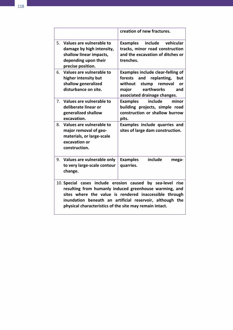
118
119
creationofnewfractures.
5. Valuesarevulnerabletodamagebyhighintensity,shallowlinearimpacts,dependingupontheirpreciseposition.
Examples include vehiculartracks,minor road constructionandtheexcavationofditchesortrenches.
6. Valuesarevulnerabletohigherintensitybutshallowgeneralizeddisturbanceonsite.
Examplesincludeclear-fellingofforests and replanting, butwithout stump removal ormajor earthworks andassociateddrainagechanges.
7. Valuesarevulnerabletodeliberatelinearorgeneralizedshallowexcavation.
Examples include minorbuilding projects, simple roadconstruction or shallowburrowpits.
8. Valuesarevulnerabletomajorremovalofgeo-materials,orlarge-scaleexcavationorconstruction.
Examples include quarries andsitesoflargedamconstruction.
9. Valuesarevulnerableonlytoverylarge-scalecontourchange.
Examples include mega-quarries.
10. Special cases include erosion caused by sea-level riseresulting from humanly induced greenhouse warming, andsites where the value is rendered inaccessible throughinundation beneath an artificial reservoir, although thephysicalcharacteristicsofthesitemayremainintact.
119
119
creationofnewfractures.
5. Valuesarevulnerabletodamagebyhighintensity,shallowlinearimpacts,dependingupontheirpreciseposition.
Examples include vehiculartracks,minor road constructionandtheexcavationofditchesortrenches.
6. Valuesarevulnerabletohigherintensitybutshallowgeneralizeddisturbanceonsite.
Examplesincludeclear-fellingofforests and replanting, butwithout stump removal ormajor earthworks andassociateddrainagechanges.
7. Valuesarevulnerabletodeliberatelinearorgeneralizedshallowexcavation.
Examples include minorbuilding projects, simple roadconstruction or shallowburrowpits.
8. Valuesarevulnerabletomajorremovalofgeo-materials,orlarge-scaleexcavationorconstruction.
Examples include quarries andsitesoflargedamconstruction.
9. Valuesarevulnerableonlytoverylarge-scalecontourchange.
Examples include mega-quarries.
10. Special cases include erosion caused by sea-level riseresulting from humanly induced greenhouse warming, andsites where the value is rendered inaccessible throughinundation beneath an artificial reservoir, although thephysicalcharacteristicsofthesitemayremainintact.
120
Appendix7
ConflictManagement
Aprocessfornegotiation/mediationThere are three broad categories of approaches to managingconflicts.Theydifferintheextenttowhichthepartiesinconflictcontroltheprocessandtheoutcome.Thesecategoriesare:Negotiation:wheretheparties,withorwithouttheassistanceofafacilitator,discusstheirdifferencesandattempttoreachajointdecision. The facilitator merely guides the process in a non-partisan manner to help the parties clarify and resolve theirdifferences.Mediation: where the parties agree to allow an independent,neutral third party (usually a person trained in mediation) tocontrol and direct the process of clarifying positions, identifyinginterests and developing solutions agreeable to all. As withnegotiation,this isavoluntaryprocesswhichthepartiescanoptoutofatanytime.Arbitration:whereeachside is requiredtopresent theircasetoan independent person who has legal authority to impose asolution.Agreementsareenforceablethroughlaw.Conditionsfornegotiation/mediationThereareavarietyofconditionswhichcanaffectthesuccessofanegotiation.Theyshouldbepresentbeforeanegotiationprocessisundertaken.Theconditionsare:
1. All the people or groups who have a stake in thenegotiationsshouldbewillingtoparticipate.
2. Parties should be ready to negotiate. They should bepsychologicallypreparedtotalktoeachother;theyshouldhaveadequateinformation;andanoutlineoftheconflictmanagement process should be prepared and agreed to.This is particularly importantwhendealingwithdifferentracial/ethnic groups, especially thosewhich have a tribalsystemwherespeakingrightsaresubjecttotraditionandthe consensus of other members. Thenegotiation/mediation process should allow time for thedifferent cultural decision-making time frames to be
120
121
accommodated, e.g. to select a spokesperson and todecidetheapproachtobetaken.
3. Each party should have some means of influencing theattitudesand/orbehavioroftheothernegotiators if theyare to reach an agreement on issues over which theydisagree.
4. The parties should have some common issues andinterestsonwhich theyareable toagree forprogress tobemade.
5. The parties should be dependent on each other to havetheirneedsmetorinterestssatisfied.Ifonepartycanhavetheir needs met without cooperating with others, therewillbelittleincentiveforthemtonegotiate.
6. They should have a willingness to settle theirdisagreements.Ifmaintainingtheconflictismoreusefultooneormoreparties(e.g.tomobilizepublicopinionintheirfavor)thennegotiationsaredoomedtofailure.
7. Theoutcomeofusingothermeanstoresolvetheproblemshouldbeunpredictable. Ifoneparty is sureof completevictoryfortheirpointofviewiftheygotocourt,ordirectlyto the government, they are unlikely to be prepared tonegotiateasettlementwhereonlysomeoftheirinterestswillbemet.
8. Allpartiesshouldfeelsomepressureorurgencytoreachadecision. Urgency may come from time constraints orpotentiallynegativeorpositiveconsequencesifsettlementisorisnotreached.
9. Theissuesshouldbenegotiable.Ifnegotiationsappeartohave only win/lose settlement possibilities, so that oneparty’sneedswillnotbemetasa resultofparticipation,thepartieswillbereluctanttoenterintotheprocess.
10. Participants should have authority to actually make adecision.
11. Thepartiesshouldbewillingtocompromiseeventhoughthismaynotalwaysbenecessary.On someoccasionsanagreement can be reachedwhichmeets the needs of allparticipantsanddoesnot require sacrificeon thepartofany.
12. Theagreementshouldbefeasibleandthepartiesshouldbeabletoputitintoaction.
13. Participantsshouldhavetheinterpersonalskillsnecessaryforbargainingaswellasthetimeandresourcestoengagefully in the process. Inadequate or unequal skills and
121
121
accommodated, e.g. to select a spokesperson and todecidetheapproachtobetaken.
3. Each party should have some means of influencing theattitudesand/orbehavioroftheothernegotiators if theyare to reach an agreement on issues over which theydisagree.
4. The parties should have some common issues andinterestsonwhich theyareable toagree forprogress tobemade.
5. The parties should be dependent on each other to havetheirneedsmetorinterestssatisfied.Ifonepartycanhavetheir needs met without cooperating with others, therewillbelittleincentiveforthemtonegotiate.
6. They should have a willingness to settle theirdisagreements.Ifmaintainingtheconflictismoreusefultooneormoreparties(e.g.tomobilizepublicopinionintheirfavor)thennegotiationsaredoomedtofailure.
7. Theoutcomeofusingothermeanstoresolvetheproblemshouldbeunpredictable. Ifoneparty is sureof completevictoryfortheirpointofviewiftheygotocourt,ordirectlyto the government, they are unlikely to be prepared tonegotiateasettlementwhereonlysomeoftheirinterestswillbemet.
8. Allpartiesshouldfeelsomepressureorurgencytoreachadecision. Urgency may come from time constraints orpotentiallynegativeorpositiveconsequencesifsettlementisorisnotreached.
9. Theissuesshouldbenegotiable.Ifnegotiationsappeartohave only win/lose settlement possibilities, so that oneparty’sneedswillnotbemetasa resultofparticipation,thepartieswillbereluctanttoenterintotheprocess.
10. Participants should have authority to actually make adecision.
11. Thepartiesshouldbewillingtocompromiseeventhoughthismaynotalwaysbenecessary.On someoccasionsanagreement can be reachedwhichmeets the needs of allparticipantsanddoesnot require sacrificeon thepartofany.
12. Theagreementshouldbefeasibleandthepartiesshouldbeabletoputitintoaction.
13. Participantsshouldhavetheinterpersonalskillsnecessaryforbargainingaswellasthetimeandresourcestoengagefully in the process. Inadequate or unequal skills and
122
resources among the parties may hinder settlement andshouldbeaddressedbeforenegotiationscommence.
Stepsinnegotiation/mediationexercisesThe process of negotiation can be viewed as compromising 13basic steps. These steps can be used as a checklist for anyonecalledupontofacilitatesuchaprocess.The steps give no indication of the time required to completethem. The actual negotiation/mediation process may take anumberofsessions.Iftheneedformoreinformationisidentifiedatanypoint,theprocessshouldbestoppeduntilthatinformationisprovided.Ifthepartiesreachapointwherenoprogressisbeingmade,theymaydecidetobreaktheprocessandeithergetbacktogether at a later date or enter into an arbitration processinstead.Thebasicstepsareasfollows:
1. Priortotheparties’meeting,checkthatallormostoftheconditions listed above are present. This will requiremeeting with the parties individually to clarify theirattitudesandpositions.
2. Set a time and place to meet that is agreeable to allparties.
3. At the beginning of the negotiation, ask each party toexplain their position clearly: what they want and why.They should not be interrupted except for points ofclarification.
4. After all parties have stated their case, identify wherethereareareasofagreement.
5. Identifyanyadditionalinformationthatanyofthepartiesneedinorderforthemtobeabletounderstandtheclaimsmadebyotherparties.Ifnecessary,stoptheprocessuntiltheycanbeprovidedwiththatinformation.
6. Identifytheareasofdisagreement.7. Agreeonacommonoverallgoalforthenegotiations(e.g.
thesustainableuseofaresourceandthemaintenanceoflivelihoodforaparticulargrouporcommunity).
8. Help the parties to compile a list of possible options tomeetthisgoal.
9. Listcriteriaagainstwhicheachoptionshouldbemeasured(e.g.urgencyofneed,feasibility,economicreturns).
10. Evaluateeachoptionagainstthesecriteria.
123
11. Facilitate an agreement on one or more options thatmaximizemutualsatisfactionamongotherparties.
12. Decideontheprocesses, responsibilitiesandtime-framesforanyactionsrequiredtoimplementtoagreement.
13. Writeupanydecisionsreachedandgetthepartiestosigntheiragreement.
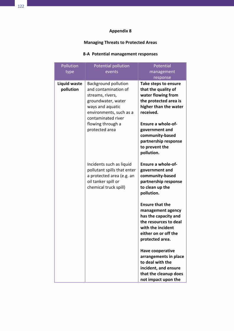
122
124
Appendix8
ManagingThreatstoProtectedAreas
8-APotentialmanagementresponses
Pollutiontype
Potentialpollutionevents
Potentialmanagement
responseLiquidwaste
pollutionBackgroundpollutionandcontaminationofstreams,rivers,groundwater,waterwaysandaquaticenvironments,suchasacontaminatedriverflowingthroughaprotectedareaIncidentssuchasliquidpollutantspillsthatenteraprotectedarea(e.g.anoiltankerspillorchemicaltruckspill)
Takestepstoensurethatthequalityofwaterflowingfromtheprotectedareaishigherthanthewaterreceived.Ensureawhole-of-governmentandcommunity-basedpartnershipresponsetopreventthepollution.Ensureawhole-of-governmentandcommunity-basedpartnershipresponsetocleanupthepollution.Ensurethatthemanagementagencyhasthecapacityandtheresourcestodealwiththeincidenteitheronorofftheprotectedarea.Havecooperativearrangementsinplacetodealwiththeincident,andensurethatthecleanupdoesnotimpactuponthe
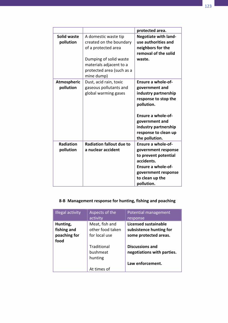
123
124
Appendix8
ManagingThreatstoProtectedAreas
8-APotentialmanagementresponses
Pollutiontype
Potentialpollutionevents
Potentialmanagement
responseLiquidwaste
pollutionBackgroundpollutionandcontaminationofstreams,rivers,groundwater,waterwaysandaquaticenvironments,suchasacontaminatedriverflowingthroughaprotectedareaIncidentssuchasliquidpollutantspillsthatenteraprotectedarea(e.g.anoiltankerspillorchemicaltruckspill)
Takestepstoensurethatthequalityofwaterflowingfromtheprotectedareaishigherthanthewaterreceived.Ensureawhole-of-governmentandcommunity-basedpartnershipresponsetopreventthepollution.Ensureawhole-of-governmentandcommunity-basedpartnershipresponsetocleanupthepollution.Ensurethatthemanagementagencyhasthecapacityandtheresourcestodealwiththeincidenteitheronorofftheprotectedarea.Havecooperativearrangementsinplacetodealwiththeincident,andensurethatthecleanupdoesnotimpactuponthe
125
protectedarea.Solidwastepollution
AdomesticwastetipcreatedontheboundaryofaprotectedareaDumpingofsolidwastematerialsadjacenttoaprotectedarea(suchasaminedump)
Negotiatewithland-useauthoritiesandneighborsfortheremovalofthesolidwaste.
Atmosphericpollution
Dust,acidrain,toxicgaseouspollutantsandglobalwarminggases
Ensureawhole-of-governmentandindustrypartnershipresponsetostopthepollution.Ensureawhole-of-governmentandindustrypartnershipresponsetocleanupthepollution.
Radiationpollution
Radiationfalloutduetoanuclearaccident
Ensureawhole-of-governmentresponsetopreventpotentialaccidents.Ensureawhole-of-governmentresponsetocleanupthepollution.
8-BManagementresponseforhunting,fishingandpoachingIllegalactivity Aspectsofthe
activityPotentialmanagementresponse
Hunting,fishingandpoachingforfood
Meat,fishandotherfoodtakenforlocaluseTraditionalbushmeathuntingAttimesof
Licensedsustainablesubsistencehuntingforsomeprotectedareas.Discussionsandnegotiationswithparties.Lawenforcement.
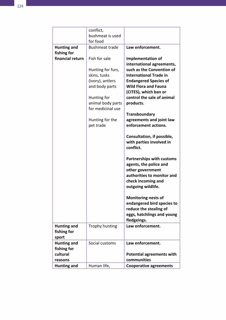
124
126
conflict,bushmeatisusedforfood
Huntingandfishingforfinancialreturn
BushmeattradeFishforsaleHuntingforfurs,skins,tusks(ivory),antlersandbodypartsHuntingforanimalbodypartsformedicinaluseHuntingforthepettrade
Lawenforcement.Implementationofinternationalagreements,suchastheConventionofInternationalTradeinEndangeredSpeciesofWildFloraandFauna(CITES),whichbanorcontrolthesaleofanimalproducts.Transboundaryagreementsandjointlawenforcementactions.Consultation,ifpossible,withpartiesinvolvedinconflict.Partnershipswithcustomsagents,thepoliceandothergovernmentauthoritiestomonitorandcheckincomingandoutgoingwildlife.Monitoringnestsofendangeredbirdspeciestoreducethestealingofeggs,hatchlingsandyoungfledgeings.
Huntingandfishingforsport
Trophyhunting Lawenforcement.
Huntingandfishingforculturalreasons
Socialcustoms Lawenforcement.Potentialagreementswithcommunities
Huntingand Humanlife, Cooperativeagreements
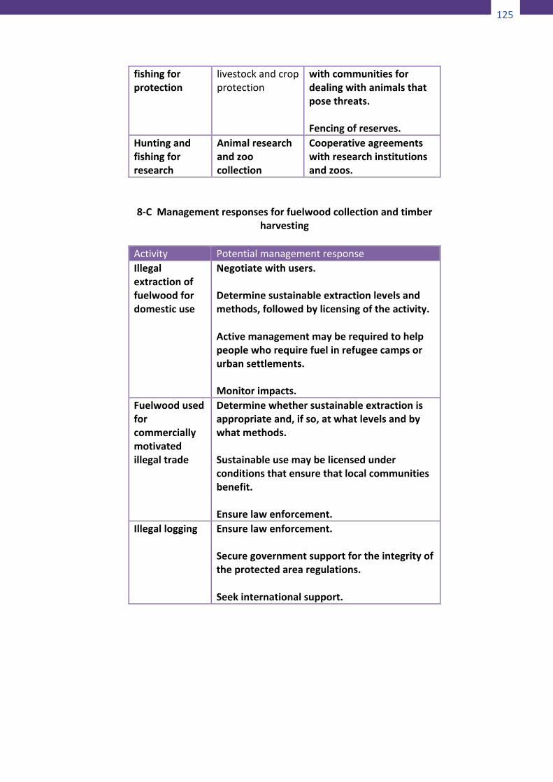
125
126
conflict,bushmeatisusedforfood
Huntingandfishingforfinancialreturn
BushmeattradeFishforsaleHuntingforfurs,skins,tusks(ivory),antlersandbodypartsHuntingforanimalbodypartsformedicinaluseHuntingforthepettrade
Lawenforcement.Implementationofinternationalagreements,suchastheConventionofInternationalTradeinEndangeredSpeciesofWildFloraandFauna(CITES),whichbanorcontrolthesaleofanimalproducts.Transboundaryagreementsandjointlawenforcementactions.Consultation,ifpossible,withpartiesinvolvedinconflict.Partnershipswithcustomsagents,thepoliceandothergovernmentauthoritiestomonitorandcheckincomingandoutgoingwildlife.Monitoringnestsofendangeredbirdspeciestoreducethestealingofeggs,hatchlingsandyoungfledgeings.
Huntingandfishingforsport
Trophyhunting Lawenforcement.
Huntingandfishingforculturalreasons
Socialcustoms Lawenforcement.Potentialagreementswithcommunities
Huntingand Humanlife, Cooperativeagreements
127
fishingforprotection
livestockandcropprotection
withcommunitiesfordealingwithanimalsthatposethreats.Fencingofreserves.
Huntingandfishingforresearch
Animalresearchandzoocollection
Cooperativeagreementswithresearchinstitutionsandzoos.
8-CManagementresponsesforfuelwoodcollectionandtimber
harvesting
Activity PotentialmanagementresponseIllegalextractionoffuelwoodfordomesticuse
Negotiatewithusers.Determinesustainableextractionlevelsandmethods,followedbylicensingoftheactivity.Activemanagementmayberequiredtohelppeoplewhorequirefuelinrefugeecampsorurbansettlements.Monitorimpacts.
Fuelwoodusedforcommerciallymotivatedillegaltrade
Determinewhethersustainableextractionisappropriateand,ifso,atwhatlevelsandbywhatmethods.Sustainableusemaybelicensedunderconditionsthatensurethatlocalcommunitiesbenefit.Ensurelawenforcement.
Illegallogging Ensurelawenforcement.Securegovernmentsupportfortheintegrityoftheprotectedarearegulations.Seekinternationalsupport.
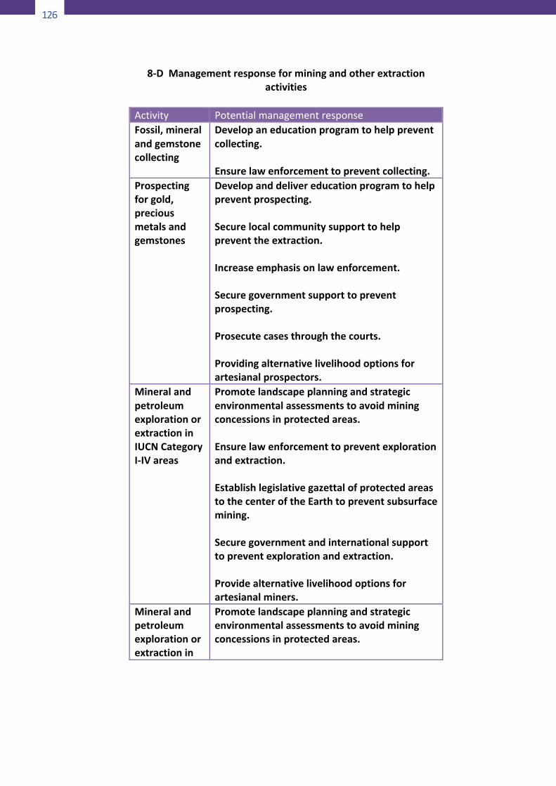
126
128
8-DManagementresponseforminingandotherextractionactivities
Activity PotentialmanagementresponseFossil,mineralandgemstonecollecting
Developaneducationprogramtohelppreventcollecting.Ensurelawenforcementtopreventcollecting.
Prospectingforgold,preciousmetalsandgemstones
Developanddelivereducationprogramtohelppreventprospecting.Securelocalcommunitysupporttohelppreventtheextraction.Increaseemphasisonlawenforcement.Securegovernmentsupporttopreventprospecting.Prosecutecasesthroughthecourts.Providingalternativelivelihoodoptionsforartesianalprospectors.
MineralandpetroleumexplorationorextractioninIUCNCategoryI-IVareas
Promotelandscapeplanningandstrategicenvironmentalassessmentstoavoidminingconcessionsinprotectedareas.Ensurelawenforcementtopreventexplorationandextraction.EstablishlegislativegazettalofprotectedareastothecenteroftheEarthtopreventsubsurfacemining.Securegovernmentandinternationalsupporttopreventexplorationandextraction.Providealternativelivelihoodoptionsforartesianalminers.
Mineralandpetroleumexplorationorextractionin
Promotelandscapeplanningandstrategicenvironmentalassessmentstoavoidminingconcessionsinprotectedareas.
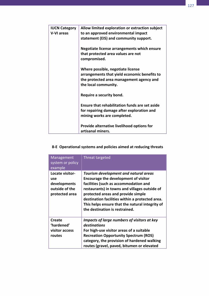
127
128
8-DManagementresponseforminingandotherextractionactivities
Activity PotentialmanagementresponseFossil,mineralandgemstonecollecting
Developaneducationprogramtohelppreventcollecting.Ensurelawenforcementtopreventcollecting.
Prospectingforgold,preciousmetalsandgemstones
Developanddelivereducationprogramtohelppreventprospecting.Securelocalcommunitysupporttohelppreventtheextraction.Increaseemphasisonlawenforcement.Securegovernmentsupporttopreventprospecting.Prosecutecasesthroughthecourts.Providingalternativelivelihoodoptionsforartesianalprospectors.
MineralandpetroleumexplorationorextractioninIUCNCategoryI-IVareas
Promotelandscapeplanningandstrategicenvironmentalassessmentstoavoidminingconcessionsinprotectedareas.Ensurelawenforcementtopreventexplorationandextraction.EstablishlegislativegazettalofprotectedareastothecenteroftheEarthtopreventsubsurfacemining.Securegovernmentandinternationalsupporttopreventexplorationandextraction.Providealternativelivelihoodoptionsforartesianalminers.
Mineralandpetroleumexplorationorextractionin
Promotelandscapeplanningandstrategicenvironmentalassessmentstoavoidminingconcessionsinprotectedareas.
129
IUCNCategoryV-VIareas
Allowlimitedexplorationorextractionsubjecttoanapprovedenvironmentalimpactstatement(EIS)andcommunitysupport.Negotiatelicensearrangementswhichensurethatprotectedareavaluesarenotcompromised.Wherepossible,negotiatelicensearrangementsthatyieldeconomicbenefitstotheprotectedareamanagementagencyandthelocalcommunity.Requireasecuritybond.Ensurethatrehabilitationfundsaresetasideforrepairingdamageafterexplorationandminingworksarecompleted.Providealternativelivelihoodoptionsforartisanalminers.
8-EOperationalsystemsandpoliciesaimedatreducingthreats
Managementsystemorpolicyexample
Threattargeted
Locatevisitor-usedevelopmentsoutsideoftheprotectedarea
TourismdevelopmentandnaturalareasEncouragethedevelopmentofvisitorfacilities(suchasaccommodationandrestaurants)intownsandvillagesoutsideofprotectedareasandprovidesimpledestinationfacilitieswithinaprotectedarea.Thishelpsensurethatthenaturalintegrityofthedestinationisrestrained.
Create‘hardened’visitoraccessroutes
ImpactsoflargenumbersofvisitorsatkeydestinationsForhigh-usevisitorareasofasuitableRecreationOpportunitySpectrum(ROS)category,theprovisionofhardenedwalkingroutes(gravel,paved,bitumenorelevated
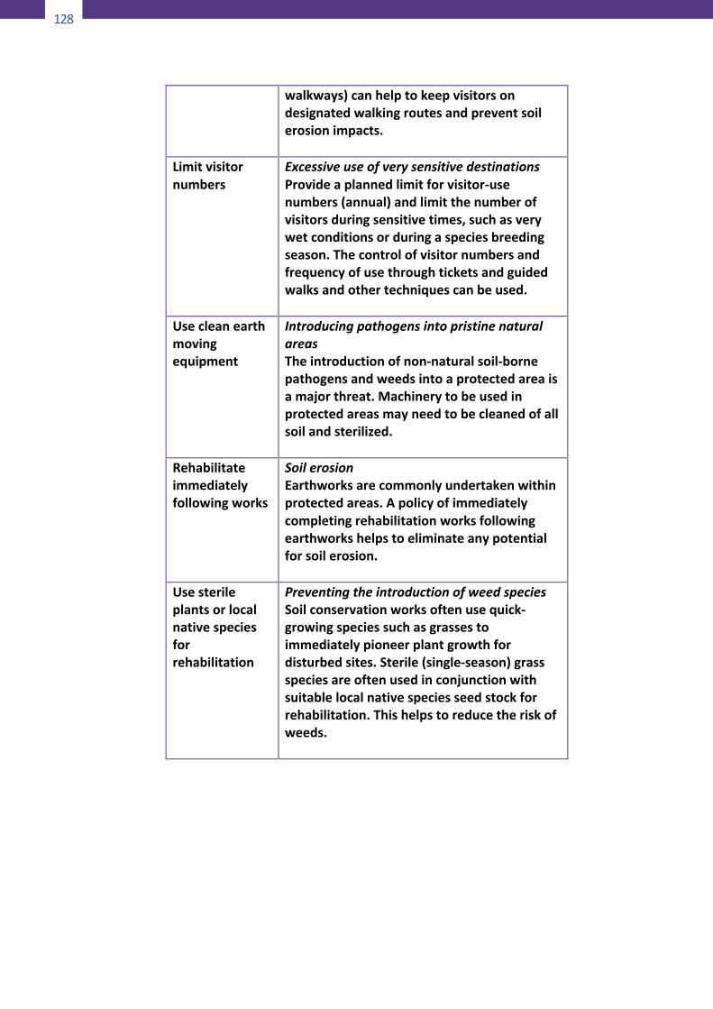
128
130
walkways)canhelptokeepvisitorsondesignatedwalkingroutesandpreventsoilerosionimpacts.
Limitvisitornumbers
ExcessiveuseofverysensitivedestinationsProvideaplannedlimitforvisitor-usenumbers(annual)andlimitthenumberofvisitorsduringsensitivetimes,suchasverywetconditionsorduringaspeciesbreedingseason.Thecontrolofvisitornumbersandfrequencyofusethroughticketsandguidedwalksandothertechniquescanbeused.
Usecleanearthmovingequipment
IntroducingpathogensintopristinenaturalareasTheintroductionofnon-naturalsoil-bornepathogensandweedsintoaprotectedareaisamajorthreat.Machinerytobeusedinprotectedareasmayneedtobecleanedofallsoilandsterilized.
Rehabilitateimmediatelyfollowingworks
SoilerosionEarthworksarecommonlyundertakenwithinprotectedareas.Apolicyofimmediatelycompletingrehabilitationworksfollowingearthworkshelpstoeliminateanypotentialforsoilerosion.
Usesterileplantsorlocalnativespeciesforrehabilitation
PreventingtheintroductionofweedspeciesSoilconservationworksoftenusequick-growingspeciessuchasgrassestoimmediatelypioneerplantgrowthfordisturbedsites.Sterile(single-season)grassspeciesareoftenusedinconjunctionwithsuitablelocalnativespeciesseedstockforrehabilitation.Thishelpstoreducetheriskofweeds.
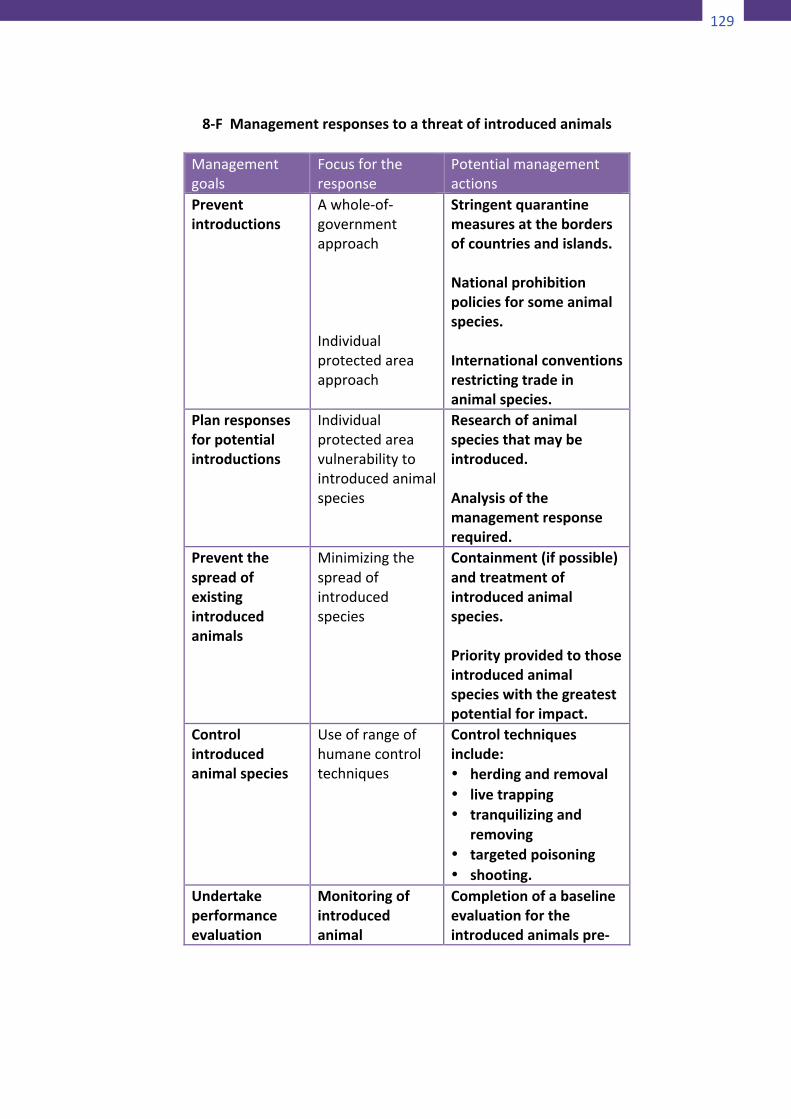
129
130
walkways)canhelptokeepvisitorsondesignatedwalkingroutesandpreventsoilerosionimpacts.
Limitvisitornumbers
ExcessiveuseofverysensitivedestinationsProvideaplannedlimitforvisitor-usenumbers(annual)andlimitthenumberofvisitorsduringsensitivetimes,suchasverywetconditionsorduringaspeciesbreedingseason.Thecontrolofvisitornumbersandfrequencyofusethroughticketsandguidedwalksandothertechniquescanbeused.
Usecleanearthmovingequipment
IntroducingpathogensintopristinenaturalareasTheintroductionofnon-naturalsoil-bornepathogensandweedsintoaprotectedareaisamajorthreat.Machinerytobeusedinprotectedareasmayneedtobecleanedofallsoilandsterilized.
Rehabilitateimmediatelyfollowingworks
SoilerosionEarthworksarecommonlyundertakenwithinprotectedareas.Apolicyofimmediatelycompletingrehabilitationworksfollowingearthworkshelpstoeliminateanypotentialforsoilerosion.
Usesterileplantsorlocalnativespeciesforrehabilitation
PreventingtheintroductionofweedspeciesSoilconservationworksoftenusequick-growingspeciessuchasgrassestoimmediatelypioneerplantgrowthfordisturbedsites.Sterile(single-season)grassspeciesareoftenusedinconjunctionwithsuitablelocalnativespeciesseedstockforrehabilitation.Thishelpstoreducetheriskofweeds.
131
8-FManagementresponsestoathreatofintroducedanimals
Managementgoals
Focusfortheresponse
Potentialmanagementactions
Preventintroductions
Awhole-of-governmentapproachIndividualprotectedareaapproach
Stringentquarantinemeasuresatthebordersofcountriesandislands.Nationalprohibitionpoliciesforsomeanimalspecies.Internationalconventionsrestrictingtradeinanimalspecies.
Planresponsesforpotentialintroductions
Individualprotectedareavulnerabilitytointroducedanimalspecies
Researchofanimalspeciesthatmaybeintroduced.Analysisofthemanagementresponserequired.
Preventthespreadofexistingintroducedanimals
Minimizingthespreadofintroducedspecies
Containment(ifpossible)andtreatmentofintroducedanimalspecies.Priorityprovidedtothoseintroducedanimalspecieswiththegreatestpotentialforimpact.
Controlintroducedanimalspecies
Useofrangeofhumanecontroltechniques
Controltechniquesinclude:• herdingandremoval• livetrapping• tranquilizingand
removing• targetedpoisoning• shooting.
Undertakeperformanceevaluation
Monitoringofintroducedanimal
Completionofabaselineevaluationfortheintroducedanimalspre-
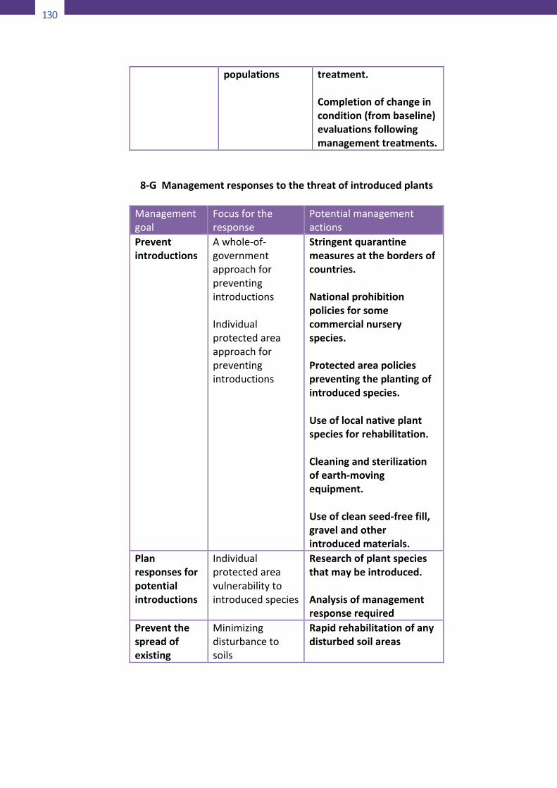
130
132
populations treatment.Completionofchangeincondition(frombaseline)evaluationsfollowingmanagementtreatments.
8-GManagementresponsestothethreatofintroducedplants
Managementgoal
Focusfortheresponse
Potentialmanagementactions
Preventintroductions
Awhole-of-governmentapproachforpreventingintroductionsIndividualprotectedareaapproachforpreventingintroductions
Stringentquarantinemeasuresatthebordersofcountries.Nationalprohibitionpoliciesforsomecommercialnurseryspecies.Protectedareapoliciespreventingtheplantingofintroducedspecies.Useoflocalnativeplantspeciesforrehabilitation.Cleaningandsterilizationofearth-movingequipment.Useofcleanseed-freefill,gravelandotherintroducedmaterials.
Planresponsesforpotentialintroductions
Individualprotectedareavulnerabilitytointroducedspecies
Researchofplantspeciesthatmaybeintroduced.Analysisofmanagementresponserequired
Preventthespreadofexisting
Minimizingdisturbancetosoils
Rapidrehabilitationofanydisturbedsoilareas
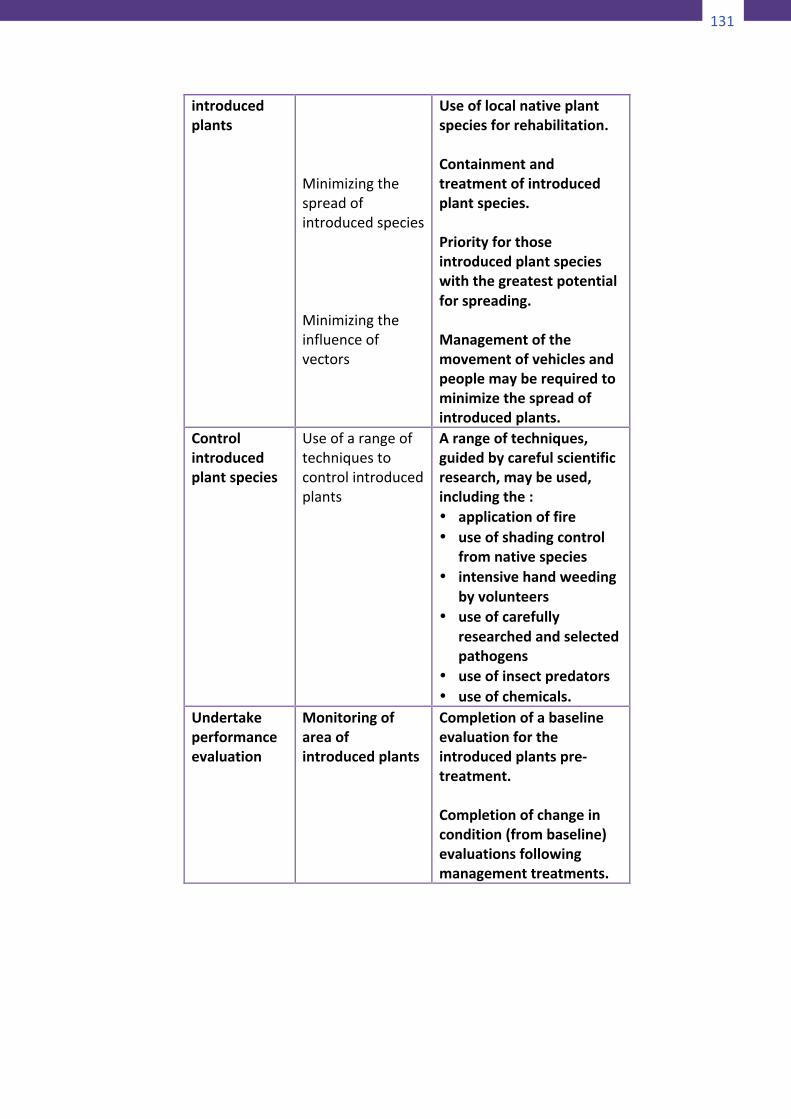
131
132
populations treatment.Completionofchangeincondition(frombaseline)evaluationsfollowingmanagementtreatments.
8-GManagementresponsestothethreatofintroducedplants
Managementgoal
Focusfortheresponse
Potentialmanagementactions
Preventintroductions
Awhole-of-governmentapproachforpreventingintroductionsIndividualprotectedareaapproachforpreventingintroductions
Stringentquarantinemeasuresatthebordersofcountries.Nationalprohibitionpoliciesforsomecommercialnurseryspecies.Protectedareapoliciespreventingtheplantingofintroducedspecies.Useoflocalnativeplantspeciesforrehabilitation.Cleaningandsterilizationofearth-movingequipment.Useofcleanseed-freefill,gravelandotherintroducedmaterials.
Planresponsesforpotentialintroductions
Individualprotectedareavulnerabilitytointroducedspecies
Researchofplantspeciesthatmaybeintroduced.Analysisofmanagementresponserequired
Preventthespreadofexisting
Minimizingdisturbancetosoils
Rapidrehabilitationofanydisturbedsoilareas
133
introducedplants
MinimizingthespreadofintroducedspeciesMinimizingtheinfluenceofvectors
Useoflocalnativeplantspeciesforrehabilitation.Containmentandtreatmentofintroducedplantspecies.Priorityforthoseintroducedplantspecieswiththegreatestpotentialforspreading.Managementofthemovementofvehiclesandpeoplemayberequiredtominimizethespreadofintroducedplants.
Controlintroducedplantspecies
Useofarangeoftechniquestocontrolintroducedplants
Arangeoftechniques,guidedbycarefulscientificresearch,maybeused,includingthe:• applicationoffire• useofshadingcontrol
fromnativespecies• intensivehandweeding
byvolunteers• useofcarefully
researchedandselectedpathogens
• useofinsectpredators• useofchemicals.
Undertakeperformanceevaluation
Monitoringofareaofintroducedplants
Completionofabaselineevaluationfortheintroducedplantspre-treatment.Completionofchangeincondition(frombaseline)evaluationsfollowingmanagementtreatments.
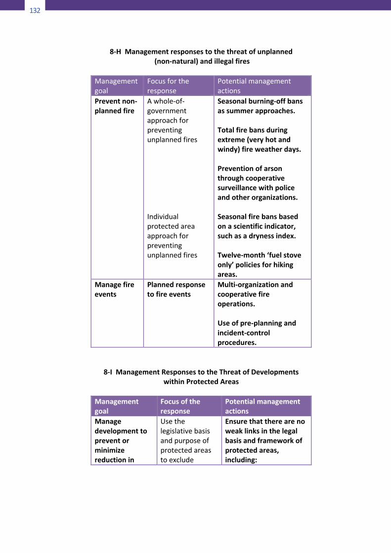
132
134
8-HManagementresponsestothethreatofunplanned(non-natural)andillegalfires
Managementgoal
Focusfortheresponse
Potentialmanagementactions
Preventnon-plannedfire
Awhole-of-governmentapproachforpreventingunplannedfiresIndividualprotectedareaapproachforpreventingunplannedfires
Seasonalburning-offbansassummerapproaches.Totalfirebansduringextreme(veryhotandwindy)fireweatherdays.Preventionofarsonthroughcooperativesurveillancewithpoliceandotherorganizations.Seasonalfirebansbasedonascientificindicator,suchasadrynessindex.Twelve-month‘fuelstoveonly’policiesforhikingareas.
Managefireevents
Plannedresponsetofireevents
Multi-organizationandcooperativefireoperations.Useofpre-planningandincident-controlprocedures.
8-IManagementResponsestotheThreatofDevelopmentswithinProtectedAreas
Managementgoal
Focusoftheresponse
Potentialmanagementactions
Managedevelopmenttopreventorminimizereductionin
Usethelegislativebasisandpurposeofprotectedareastoexclude
Ensurethattherearenoweaklinksinthelegalbasisandframeworkofprotectedareas,including:
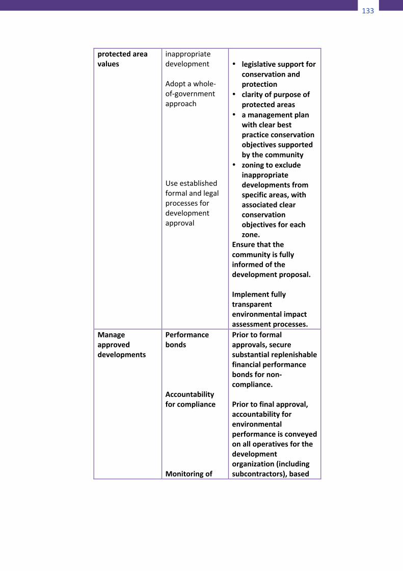
133
134
8-HManagementresponsestothethreatofunplanned(non-natural)andillegalfires
Managementgoal
Focusfortheresponse
Potentialmanagementactions
Preventnon-plannedfire
Awhole-of-governmentapproachforpreventingunplannedfiresIndividualprotectedareaapproachforpreventingunplannedfires
Seasonalburning-offbansassummerapproaches.Totalfirebansduringextreme(veryhotandwindy)fireweatherdays.Preventionofarsonthroughcooperativesurveillancewithpoliceandotherorganizations.Seasonalfirebansbasedonascientificindicator,suchasadrynessindex.Twelve-month‘fuelstoveonly’policiesforhikingareas.
Managefireevents
Plannedresponsetofireevents
Multi-organizationandcooperativefireoperations.Useofpre-planningandincident-controlprocedures.
8-IManagementResponsestotheThreatofDevelopmentswithinProtectedAreas
Managementgoal
Focusoftheresponse
Potentialmanagementactions
Managedevelopmenttopreventorminimizereductionin
Usethelegislativebasisandpurposeofprotectedareastoexclude
Ensurethattherearenoweaklinksinthelegalbasisandframeworkofprotectedareas,including:
135
protectedareavalues
inappropriatedevelopmentAdoptawhole-of-governmentapproachUseestablishedformalandlegalprocessesfordevelopmentapproval
• legislativesupportfor
conservationandprotection
• clarityofpurposeofprotectedareas
• amanagementplanwithclearbestpracticeconservationobjectivessupportedbythecommunity
• zoningtoexcludeinappropriatedevelopmentsfromspecificareas,withassociatedclearconservationobjectivesforeachzone.
Ensurethatthecommunityisfullyinformedofthedevelopmentproposal.Implementfullytransparentenvironmentalimpactassessmentprocesses.
Manageapproveddevelopments
PerformancebondsAccountabilityforcomplianceMonitoringof
Priortoformalapprovals,securesubstantialreplenishablefinancialperformancebondsfornon-compliance.Priortofinalapproval,accountabilityforenvironmentalperformanceisconveyedonalloperativesforthedevelopmentorganization(includingsubcontractors),based
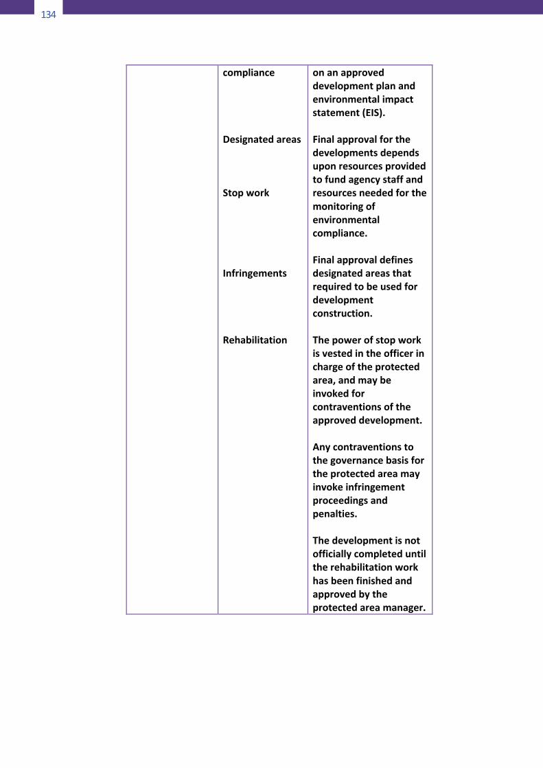
134
136
complianceDesignatedareasStopworkInfringementsRehabilitation
onanapproveddevelopmentplanandenvironmentalimpactstatement(EIS).Finalapprovalforthedevelopmentsdependsuponresourcesprovidedtofundagencystaffandresourcesneededforthemonitoringofenvironmentalcompliance.Finalapprovaldefinesdesignatedareasthatrequiredtobeusedfordevelopmentconstruction.Thepowerofstopworkisvestedintheofficerinchargeoftheprotectedarea,andmaybeinvokedforcontraventionsoftheapproveddevelopment.Anycontraventionstothegovernancebasisfortheprotectedareamayinvokeinfringementproceedingsandpenalties.Thedevelopmentisnotofficiallycompleteduntiltherehabilitationworkhasbeenfinishedandapprovedbytheprotectedareamanager.
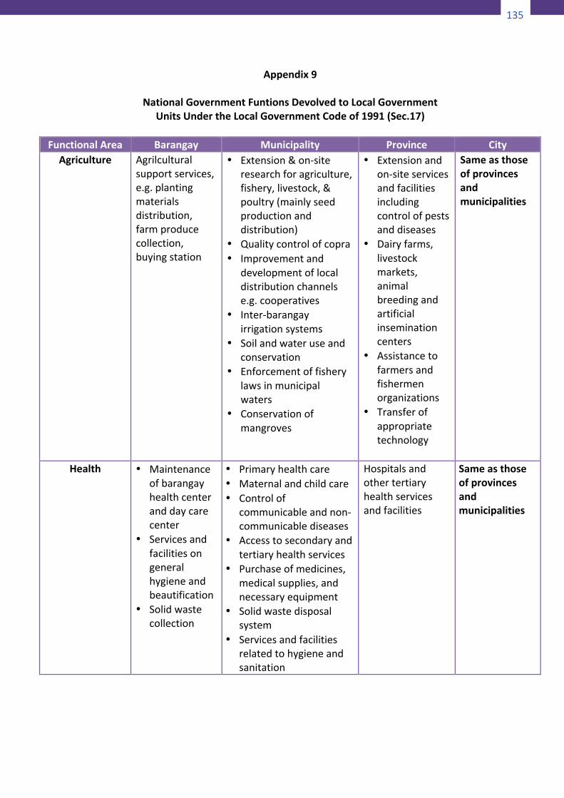
135
136
complianceDesignatedareasStopworkInfringementsRehabilitation
onanapproveddevelopmentplanandenvironmentalimpactstatement(EIS).Finalapprovalforthedevelopmentsdependsuponresourcesprovidedtofundagencystaffandresourcesneededforthemonitoringofenvironmentalcompliance.Finalapprovaldefinesdesignatedareasthatrequiredtobeusedfordevelopmentconstruction.Thepowerofstopworkisvestedintheofficerinchargeoftheprotectedarea,andmaybeinvokedforcontraventionsoftheapproveddevelopment.Anycontraventionstothegovernancebasisfortheprotectedareamayinvokeinfringementproceedingsandpenalties.Thedevelopmentisnotofficiallycompleteduntiltherehabilitationworkhasbeenfinishedandapprovedbytheprotectedareamanager.
137
Appendix9
NationalGovernmentFuntionsDevolvedtoLocalGovernmentUnitsUndertheLocalGovernmentCodeof1991(Sec.17)
FunctionalArea Barangay Municipality Province City
Agriculture Agrilculturalsupportservices,e.g.plantingmaterialsdistribution,farmproducecollection,buyingstation
• Extension&on-siteresearchforagriculture,fishery,livestock,&poultry(mainlyseedproductionanddistribution)
• Qualitycontrolofcopra• Improvementand
developmentoflocaldistributionchannelse.g.cooperatives
• Inter-barangayirrigationsystems
• Soilandwateruseandconservation
• Enforcementoffisherylawsinmunicipalwaters
• Conservationofmangroves
• Extensionandon-siteservicesandfacilitiesincludingcontrolofpestsanddiseases
• Dairyfarms,livestockmarkets,animalbreedingandartificialinseminationcenters
• Assistancetofarmersandfishermenorganizations
• Transferofappropriatetechnology
Sameasthoseofprovincesandmunicipalities
Health
• Maintenanceofbarangayhealthcenteranddaycarecenter
• Servicesandfacilitiesongeneralhygieneandbeautification
• Solidwastecollection
• Primaryhealthcare• Maternalandchildcare• Controlof
communicableandnon-communicablediseases
• Accesstosecondaryandtertiaryhealthservices
• Purchaseofmedicines,medicalsupplies,andnecessaryequipment
• Solidwastedisposalsystem
• Servicesandfacilitiesrelatedtohygieneandsanitation
Hospitalsandothertertiaryhealthservicesandfacilities
Sameasthoseofprovincesandmunicipalities
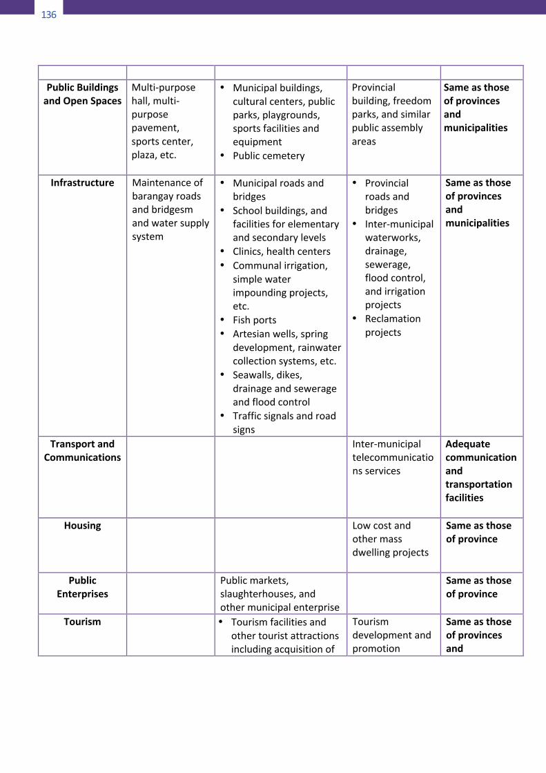
136
138
PublicBuildingsandOpenSpaces
Multi-purposehall,multi-purposepavement,sportscenter,plaza,etc.
• Municipalbuildings,culturalcenters,publicparks,playgrounds,sportsfacilitiesandequipment
• Publiccemetery
Provincialbuilding,freedomparks,andsimilarpublicassemblyareas
Sameasthoseofprovincesandmunicipalities
Infrastructure Maintenanceofbarangayroadsandbridgesmandwatersupplysystem
• Municipalroadsandbridges
• Schoolbuildings,andfacilitiesforelementaryandsecondarylevels
• Clinics,healthcenters• Communalirrigation,
simplewaterimpoundingprojects,etc.
• Fishports• Artesianwells,spring
development,rainwatercollectionsystems,etc.
• Seawalls,dikes,drainageandsewerageandfloodcontrol
• Trafficsignalsandroadsigns
• Provincialroadsandbridges
• Inter-municipalwaterworks,drainage,sewerage,floodcontrol,andirrigationprojects
• Reclamationprojects
Sameasthoseofprovincesandmunicipalities
TransportandCommunications
Inter-municipaltelecommunicationsservices
Adequatecommunicationandtransportationfacilities
Housing
Lowcostandothermassdwellingprojects
Sameasthoseofprovince
PublicEnterprises
Publicmarkets,slaughterhouses,andothermunicipalenterprise
Sameasthoseofprovince
Tourism
• Tourismfacilitiesandothertouristattractionsincludingacquisitionof
Tourismdevelopmentandpromotion
Sameasthoseofprovincesand
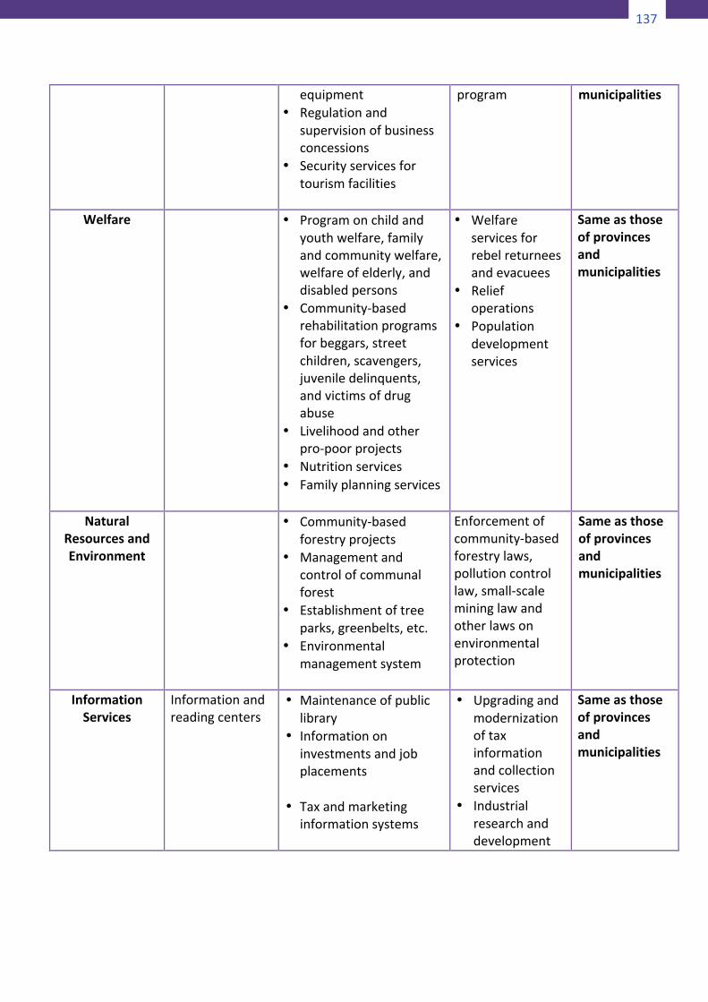
137
138
PublicBuildingsandOpenSpaces
Multi-purposehall,multi-purposepavement,sportscenter,plaza,etc.
• Municipalbuildings,culturalcenters,publicparks,playgrounds,sportsfacilitiesandequipment
• Publiccemetery
Provincialbuilding,freedomparks,andsimilarpublicassemblyareas
Sameasthoseofprovincesandmunicipalities
Infrastructure Maintenanceofbarangayroadsandbridgesmandwatersupplysystem
• Municipalroadsandbridges
• Schoolbuildings,andfacilitiesforelementaryandsecondarylevels
• Clinics,healthcenters• Communalirrigation,
simplewaterimpoundingprojects,etc.
• Fishports• Artesianwells,spring
development,rainwatercollectionsystems,etc.
• Seawalls,dikes,drainageandsewerageandfloodcontrol
• Trafficsignalsandroadsigns
• Provincialroadsandbridges
• Inter-municipalwaterworks,drainage,sewerage,floodcontrol,andirrigationprojects
• Reclamationprojects
Sameasthoseofprovincesandmunicipalities
TransportandCommunications
Inter-municipaltelecommunicationsservices
Adequatecommunicationandtransportationfacilities
Housing
Lowcostandothermassdwellingprojects
Sameasthoseofprovince
PublicEnterprises
Publicmarkets,slaughterhouses,andothermunicipalenterprise
Sameasthoseofprovince
Tourism
• Tourismfacilitiesandothertouristattractionsincludingacquisitionof
Tourismdevelopmentandpromotion
Sameasthoseofprovincesand
139
equipment• Regulationand
supervisionofbusinessconcessions
• Securityservicesfortourismfacilities
program
municipalities
Welfare
• Programonchildandyouthwelfare,familyandcommunitywelfare,welfareofelderly,anddisabledpersons
• Community-basedrehabilitationprogramsforbeggars,streetchildren,scavengers,juveniledelinquents,andvictimsofdrugabuse
• Livelihoodandotherpro-poorprojects
• Nutritionservices• Familyplanningservices
• Welfareservicesforrebelreturneesandevacuees
• Reliefoperations
• Populationdevelopmentservices
Sameasthoseofprovincesandmunicipalities
NaturalResourcesandEnvironment
• Community-basedforestryprojects
• Managementandcontrolofcommunalforest
• Establishmentoftreeparks,greenbelts,etc.
• Environmentalmanagementsystem
Enforcementofcommunity-basedforestrylaws,pollutioncontrollaw,small-scalemininglawandotherlawsonenvironmentalprotection
Sameasthoseofprovincesandmunicipalities
InformationServices
Informationandreadingcenters
• Maintenanceofpubliclibrary
• Informationoninvestmentsandjobplacements
• Taxandmarketing
informationsystems
• Upgradingandmodernizationoftaxinformationandcollectionservices
• Industrialresearchanddevelopment
Sameasthoseofprovincesandmunicipalities
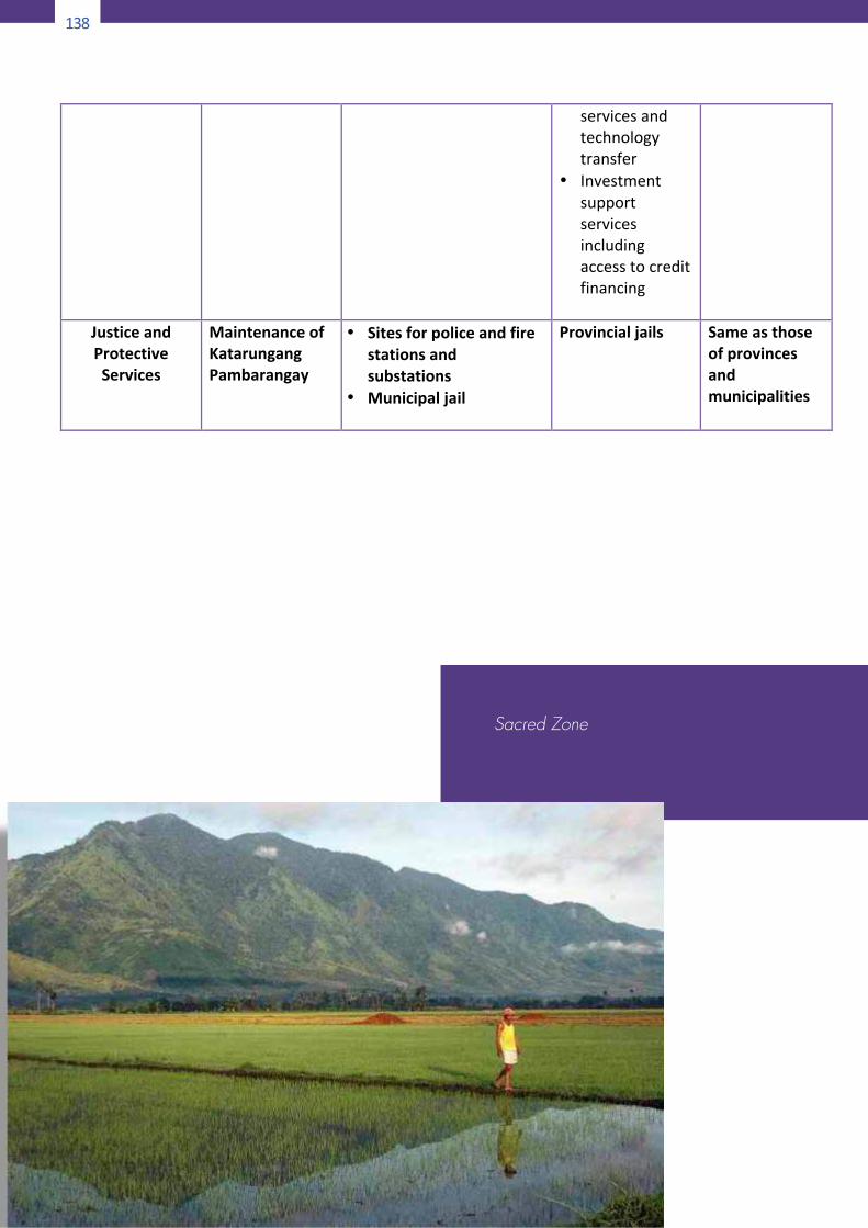
138
140
servicesandtechnologytransfer
• Investmentsupportservicesincludingaccesstocreditfinancing
JusticeandProtectiveServices
MaintenanceofKatarungangPambarangay
• Sitesforpoliceandfirestationsandsubstations
• Municipaljail
Provincialjails
Sameasthoseofprovincesandmunicipalities
Sacred Zone
139
140
servicesandtechnologytransfer
• Investmentsupportservicesincludingaccesstocreditfinancing
JusticeandProtectiveServices
MaintenanceofKatarungangPambarangay
• Sitesforpoliceandfirestationsandsubstations
• Municipaljail
Provincialjails
Sameasthoseofprovincesandmunicipalities
141
Appendix10
TypesofParticipatoryMonitoringandEvaluation
10-AStakeholderaccountsStakeholderaccounts—verbalpresentationsbasedonasetlistofquestions about key aspects of the conservation initiative—canprovide good grassroots perspectives about the initiative’soperations and achievements. Field-based staff and stakeholderrepresentatives prepare a presentation for a meeting with thecommunityandthemanagementoftheinitiative.Visualmaterialsmay ormay not be used, depending on resources available andthe type of issues to be covered. A variety of groups should begivenachancetopresenttoensurethatalltheissuesarecoveredindepthandthattheinterestsofallstakeholdersareconsidered.Eachpresentationshouldtakenolongerthan20minutes.PurposeVerbalpresentationsareaformofstory-telling.Assuch,theycanbeanaturalandnon-threateningwayofcommunicatingconcernsand ideas for some traditional cultures. People listen to theaccounts,assessthemessages,askquestionstoclarifyparticularpoints, and then in a group setting (involving both the localpeople andmanagement of the initiative), decidewhat changesneedtobemadeandhowthesecanbeachieved.Stepsinusingthetool• Together with the local stakeholder representatives (e.g. the
Conservation Council if one exists) prepare a list of topics tocover in the presentations. Questions should be open-endedandmaydifferforfieldworkersandstakeholders.Appropriatequestions for stakeholders could be: “What has changed foryou since the initiative began? What has changed in theenvironment?Howdoyouknowthesechangeshaveoccurred?Whatdoyouthinkisworkingwellintheinitiative?Whatisnotworkingsowell?Haveyouhadanyproblemswiththeinitiativestaff/management? Are you happy with the way theseproblemsweredealtwith?Canyousuggestthingsthatwouldmake the initiative work better?” Some of these questionswouldalsobeappropriateforthefieldworkers.Thefieldstaffmaybeinterestedinpresentingontopicssuchastheadequacy
140
142
oftheirtraining,supervisionandprovisionofresources.Thesemay be addressed but they are best dealtwith in detail in aseparatemeetingforstaffonly.
• Identifywhich stakeholder representatives and field staffwillgive thepresentationsandprovideeachof themwith the listofquestionstouseasaguide.Stressthattheyshouldfeelfreeto raiseothermatters they feelneed tobecovered.Allowatleast aweek for people toprepare their thoughtsbefore themeeting.
• At the evaluation meeting, encourage those present to askquestions after each presentation, and to add to theinformationpresented.
• Note the main points/issues to be addressed on ablackboard/flipchart,etc.
• At the end of the presentation, review the main points, anddiscuss the options/strategies for addressing theissues/problemsraisedandforbuildingonthesuccesses.
• Before coming to any conclusions, it may be appropriate tofollow up the presentationswith a field visit to view specificaspectsraisedinthepresentations.
10-BCommunityinvolvementinplantheevaluation
Evaluating initiatives provides an opportunity for both outsidersand insiders to reflect on the past in order to make decisionsabout the future. In a participatory process to design anevaluation,insidersareencouragedandsupportedbyoutsiderstotake responsibility for and control of planning what is to beevaluatedanddecidinghowtheevaluationwillbedone.Muchofthe material acquired from the participatory informationgathering, assessment and planning exercises can be used inparticipatoryevaluation.PurposeInvolving the community in developing an evaluation processensuresthatallaspectsofconcernarecovered.Italsoenablestheskills and knowledge available within the community to beidentifiedandutilizedforinformationcollectionandanalysis.Thisreducesrelianceonoutsiders(e.g.consultants)whomaybemuchmoreexpensiveandlessformedtodothiswork.
141
142
oftheirtraining,supervisionandprovisionofresources.Thesemay be addressed but they are best dealtwith in detail in aseparatemeetingforstaffonly.
• Identifywhich stakeholder representatives and field staffwillgive thepresentationsandprovideeachof themwith the listofquestionstouseasaguide.Stressthattheyshouldfeelfreeto raiseothermatters they feelneed tobecovered.Allowatleast aweek for people toprepare their thoughtsbefore themeeting.
• At the evaluation meeting, encourage those present to askquestions after each presentation, and to add to theinformationpresented.
• Note the main points/issues to be addressed on ablackboard/flipchart,etc.
• At the end of the presentation, review the main points, anddiscuss the options/strategies for addressing theissues/problemsraisedandforbuildingonthesuccesses.
• Before coming to any conclusions, it may be appropriate tofollow up the presentationswith a field visit to view specificaspectsraisedinthepresentations.
10-BCommunityinvolvementinplantheevaluation
Evaluating initiatives provides an opportunity for both outsidersand insiders to reflect on the past in order to make decisionsabout the future. In a participatory process to design anevaluation,insidersareencouragedandsupportedbyoutsiderstotake responsibility for and control of planning what is to beevaluatedanddecidinghowtheevaluationwillbedone.Muchofthe material acquired from the participatory informationgathering, assessment and planning exercises can be used inparticipatoryevaluation.PurposeInvolving the community in developing an evaluation processensuresthatallaspectsofconcernarecovered.Italsoenablestheskills and knowledge available within the community to beidentifiedandutilizedforinformationcollectionandanalysis.Thisreducesrelianceonoutsiders(e.g.consultants)whomaybemuchmoreexpensiveandlessformedtodothiswork.
143
Theresultsof theevaluationexerciseshouldenabledecisionstobe reached on whether to change the objectives of theconservation initiative, change the strategy, change activities orcontinueallor someof these. Inaparticipatoryevaluationbothspecific activities and the objectives of the initiative areconsidered,withtheobjectivesoflearningwhatworkedandwhy,andwhatwasnotsuccessfulandwhyitwasn’t.StepsinusingtheprocessThese steps can be undertaken with a group of stakeholderrepresentatives(e.g.aConservationCouncil)orinameetingopentoeveryone.• Review the objectives and activities of the initiative and the
reasonsfortheevaluationi.e.“whatdowewanttoknow?”• Develop evaluation process—these can be written on large
sheetsofpaperorablackboard—andrankthem.• Decidewhowilldotheevaluation(e.g. thewholecommunity
inanopenmeeting, a team representingmajor stakeholders,oranoutsideconsultant).
• Identify direct and indirect indicators. Direct indicators arefacts and information that directly relate to what is beingmeasured (e.g. the number of cattle owned by a family).Indirect indicators provide information on aspects whichcannotbeeasilyoraccuratelymeasured(e.g.whetherafamilypossessesaradioorabicyclecan,insomecommunities,beanappropriateindirectindicatorofitstotalwealth).
• Identifytheinformationsourcesforevaluationquestions.Iftheinformation is not currently available, decide whichinformation-gatheringtoolwouldbeappropriate. Ifatoolhasbeen used before, it may be used again to update theinformationandshowthechangethathasoccurred.
• Identifytheskillsandtimerequiredtoobtaintheinformation,including any expertise that may need to be recruited fromelsewhere.
• Decidethetime-frameforgatheringandanalyzinginformation.Timing needs to take into account factors such as seasonalconstraints,religiousholidays,andfieldstaffavailability.
• Decide which people will gather which information. If anoutside evaluator is to be employed, designate someone towhomthispersonwillreport.
142
144
• Decidehowtheinformationshouldbeanalyzedandpresentedto the wider community and the staff of the conservationinitiativefordiscussionanddrawingconclusions.
10-CSWOLanalysisStrengths, weaknesses, opportunities and limitations (SWOL)analysis is a structured brainstorming process to elicit groupperceptions of a specific aspect of, for instance, a community,environment or project. The aspect is analyzed in terms of thepositive factors (strengths), negative factors (weaknesses),possible improvements (opportunities) and constraints(limitations).PurposeSWOLanalysiscanbeusefulforevaluatingactivitiescarriedoutinaconservation initiative. Itcanbe focusedonspecificaspectsofthe initiative, such as services provided by external agencies oractivities being undertakenby a local community. It can also beused by specific interests (or stakeholders) to clarify their viewsonaproposalbeforemeetingwithotherinterestgroups.Stepsinusingthetool• A number of specific aspects/topics to be evaluated are
identifiedand listedonebelowtheotheronablackboardorsheetofpaper.
• Afour-columnmatrixisdrawnonthesideofthefirstcolumn,and the four categoriesareexplained toparticipants.To thisend it may be helpful to phrase the four categories asquestionse.g.“Whatarethegoodthingsaboutthisparticularservice/activity, what has worked well?” (S); “What are thethingsthathavenotworkedwell?”(W);“Whatchancestowehavetomakethingsbetter?”(O)and“Whatthingsmightworkagainstustostopusachievingtheopportunities?”(L).
• Foreachaspecttobeevaluated,listedonthefirstcolumn,thegroupidentifiesthestrengths,weaknesses,opportunitiesandlimitations,whicharerecordedintherelevantcolumnsontheside.
• There are two ways to approach this exercise. You can gothroughall the strengths and thenall theweaknesses for allthe aspects tobeevaluated;or you can go through the four
143
144
• Decidehowtheinformationshouldbeanalyzedandpresentedto the wider community and the staff of the conservationinitiativefordiscussionanddrawingconclusions.
10-CSWOLanalysisStrengths, weaknesses, opportunities and limitations (SWOL)analysis is a structured brainstorming process to elicit groupperceptions of a specific aspect of, for instance, a community,environment or project. The aspect is analyzed in terms of thepositive factors (strengths), negative factors (weaknesses),possible improvements (opportunities) and constraints(limitations).PurposeSWOLanalysiscanbeusefulforevaluatingactivitiescarriedoutinaconservation initiative. Itcanbe focusedonspecificaspectsofthe initiative, such as services provided by external agencies oractivities being undertakenby a local community. It can also beused by specific interests (or stakeholders) to clarify their viewsonaproposalbeforemeetingwithotherinterestgroups.Stepsinusingthetool• A number of specific aspects/topics to be evaluated are
identifiedand listedonebelowtheotheronablackboardorsheetofpaper.
• Afour-columnmatrixisdrawnonthesideofthefirstcolumn,and the four categoriesareexplained toparticipants.To thisend it may be helpful to phrase the four categories asquestionse.g.“Whatarethegoodthingsaboutthisparticularservice/activity, what has worked well?” (S); “What are thethingsthathavenotworkedwell?”(W);“Whatchancestowehavetomakethingsbetter?”(O)and“Whatthingsmightworkagainstustostopusachievingtheopportunities?”(L).
• Foreachaspecttobeevaluated,listedonthefirstcolumn,thegroupidentifiesthestrengths,weaknesses,opportunitiesandlimitations,whicharerecordedintherelevantcolumnsontheside.
• There are two ways to approach this exercise. You can gothroughall the strengths and thenall theweaknesses for allthe aspects tobeevaluated;or you can go through the four
145
categoriesforeachitembeforemovingontothenextitem.Asmall test of the process use may help you decide whichapproachwillworkbestineachinstance.
• Wheretherearedifferentopinionsaskedaboutan issue,thefacilitator shouldhelp thegroup to reachaconsensus.Somepoints may need to be discussed at length. Comments arerecorded on the matrix only after agreement has beenreached.
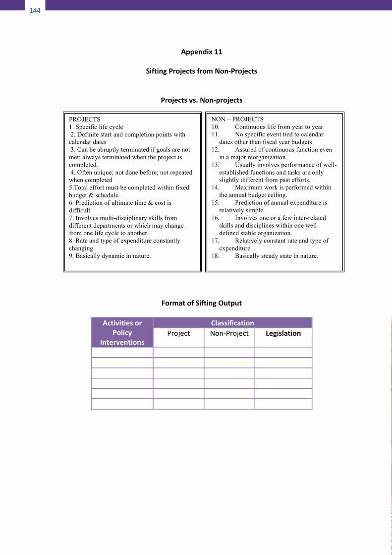
144
146
Appendix11
SiftingProjectsfromNon-Projects
Projectsvs.Non-projects
FormatofSiftingOutput
ActivitiesorPolicy
Interventions
ClassificationProject Non-Project Legislation
PROJECTS 1. Specific life cycle 2. Definite start and completion points with calendar dates 3. Can be abruptly terminated if goals are not met; always terminated when the project is completed. 4. Often unique; not done before; not repeated when completed 5.Total effort must be completed within fixed budget & schedule. 6. Prediction of ultimate time & cost is difficult. 7. Involves multi-disciplinary skills from different departments or which may change from one life cycle to another. 8. Rate and type of expenditure constantly changing. 9. Basically dynamic in nature.
NON – PROJECTS 10. Continuous life from year to year 11. No specific event tied to calendar
dates other than fiscal year budgets 12. Assured of continuous function even
in a major reorganization. 13. Usually involves performance of well-
established functions and tasks are only slightly different from past efforts.
14. Maximum work is performed within the annual budget ceiling.
15. Prediction of annual expenditure is relatively simple.
16. Involves one or a few inter-related skills and disciplines within one well-defined stable organization.
17. Relatively constant rate and type of expenditure
18. Basically steady state in nature.
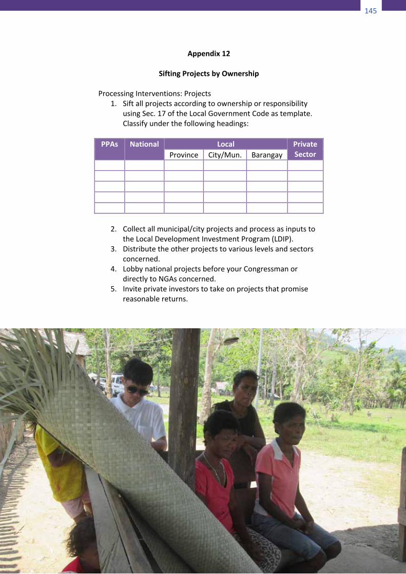
145
146
Appendix11
SiftingProjectsfromNon-Projects
Projectsvs.Non-projects
FormatofSiftingOutput
ActivitiesorPolicy
Interventions
ClassificationProject Non-Project Legislation
PROJECTS 1. Specific life cycle 2. Definite start and completion points with calendar dates 3. Can be abruptly terminated if goals are not met; always terminated when the project is completed. 4. Often unique; not done before; not repeated when completed 5.Total effort must be completed within fixed budget & schedule. 6. Prediction of ultimate time & cost is difficult. 7. Involves multi-disciplinary skills from different departments or which may change from one life cycle to another. 8. Rate and type of expenditure constantly changing. 9. Basically dynamic in nature.
NON – PROJECTS 10. Continuous life from year to year 11. No specific event tied to calendar
dates other than fiscal year budgets 12. Assured of continuous function even
in a major reorganization. 13. Usually involves performance of well-
established functions and tasks are only slightly different from past efforts.
14. Maximum work is performed within the annual budget ceiling.
15. Prediction of annual expenditure is relatively simple.
16. Involves one or a few inter-related skills and disciplines within one well-defined stable organization.
17. Relatively constant rate and type of expenditure
18. Basically steady state in nature.
147
Appendix12
SiftingProjectsbyOwnershipProcessingInterventions:Projects
1. SiftallprojectsaccordingtoownershiporresponsibilityusingSec.17oftheLocalGovernmentCodeastemplate.Classifyunderthefollowingheadings:
PPAs National Local Private
SectorProvince City/Mun. Barangay
2. Collectallmunicipal/cityprojectsandprocessasinputstotheLocalDevelopmentInvestmentProgram(LDIP).
3. Distributetheotherprojectstovariouslevelsandsectorsconcerned.
4. LobbynationalprojectsbeforeyourCongressmanordirectlytoNGAsconcerned.
5. Inviteprivateinvestorstotakeonprojectsthatpromisereasonablereturns.
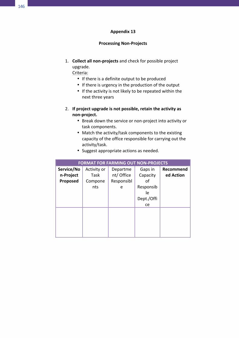
146
148
Appendix13
ProcessingNon-Projects
1. Collectallnon-projectsandcheckforpossibleprojectupgrade.
Criteria:• Ifthereisadefiniteoutputtobeproduced• Ifthereisurgencyintheproductionoftheoutput• Iftheactivityisnotlikelytoberepeatedwithinthe
nextthreeyears
2. Ifprojectupgradeisnotpossible,retaintheactivityasnon-project.• Breakdowntheserviceornon-projectintoactivityor
taskcomponents.• Matchtheactivity/taskcomponentstotheexisting
capacityoftheofficeresponsibleforcarryingouttheactivity/task.
• Suggestappropriateactionsasneeded.
FORMATFORFARMINGOUTNON-PROJECTSService/Non-ProjectProposed
ActivityorTask
Components
Department/OfficeResponsibl
e
GapsinCapacity
ofResponsib
leDept./Offi
ce
RecommendedAction
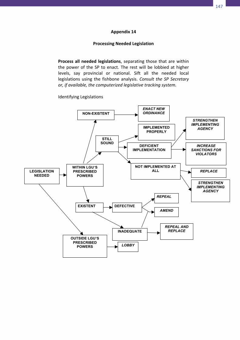
147
148
Appendix13
ProcessingNon-Projects
1. Collectallnon-projectsandcheckforpossibleprojectupgrade.
Criteria:• Ifthereisadefiniteoutputtobeproduced• Ifthereisurgencyintheproductionoftheoutput• Iftheactivityisnotlikelytoberepeatedwithinthe
nextthreeyears
2. Ifprojectupgradeisnotpossible,retaintheactivityasnon-project.• Breakdowntheserviceornon-projectintoactivityor
taskcomponents.• Matchtheactivity/taskcomponentstotheexisting
capacityoftheofficeresponsibleforcarryingouttheactivity/task.
• Suggestappropriateactionsasneeded.
FORMATFORFARMINGOUTNON-PROJECTSService/Non-ProjectProposed
ActivityorTask
Components
Department/OfficeResponsibl
e
GapsinCapacity
ofResponsib
leDept./Offi
ce
RecommendedAction
149
Appendix14
ProcessingNeededLegislationProcessallneeded legislations, separating those thatarewithinthepowerof the SP toenact. The restwill be lobbiedathigherlevels, say provincial or national. Sift all the needed locallegislations using the fishbone analysis. Consult the SP Secretaryor,ifavailable,thecomputerizedlegislativetrackingsystem.IdentifyingLegislations
LEGISLATION NEEDED
NON-EXISTENT ENACT NEW ORDINANCE
OUTSIDE LGU’S PRESCRIBED
POWERS
REPEAL
DEFECTIVE
IMPLEMENTED PROPERLY
DEFICIENT IMPLEMENTATION
STRENGTHEN IMPLEMENTING
AGENCY
WITHIN LGU’S PRESCRIBED
POWERS
STILL SOUND
EXISTENT
INADEQUATE
AMEND
REPEAL AND REPLACE
REPLACE
INCREASE SANCTIONS FOR
VIOLATORS
STRENGTHEN IMPLEMENTING
AGENCY
NOT IMPLEMENTED AT ALL
LOBBY
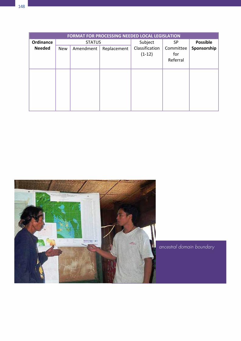
148
150
FORMATFORPROCESSINGNEEDEDLOCALLEGISLATIONOrdinanceNeeded
STATUS SubjectClassification
(1-12)
SPCommittee
forReferral
PossibleSponsorship
New
Amendment
Replacement
ancestral domain boundary
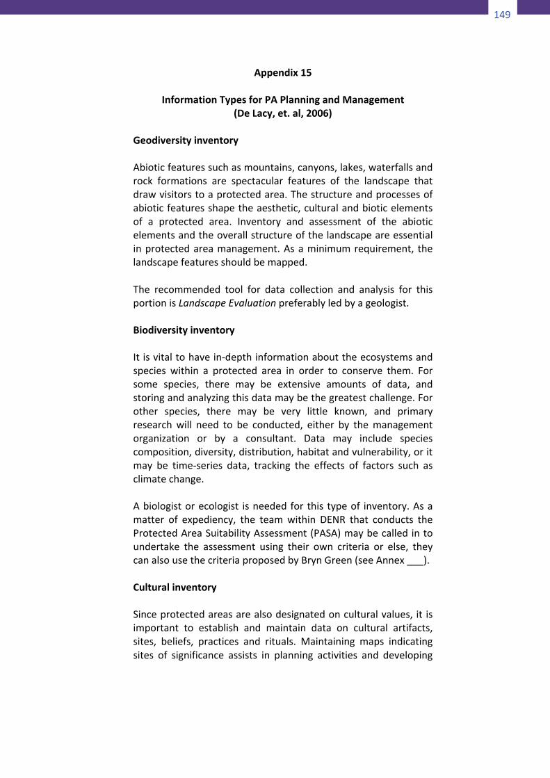
149
150
FORMATFORPROCESSINGNEEDEDLOCALLEGISLATIONOrdinanceNeeded
STATUS SubjectClassification
(1-12)
SPCommittee
forReferral
PossibleSponsorship
New
Amendment
Replacement
ancestral domain boundary
151
Appendix15
InformationTypesforPAPlanningandManagement(DeLacy,et.al,2006)
GeodiversityinventoryAbioticfeaturessuchasmountains,canyons,lakes,waterfallsandrock formations are spectacular features of the landscape thatdrawvisitorstoaprotectedarea.Thestructureandprocessesofabioticfeaturesshapetheaesthetic,culturalandbioticelementsof a protected area. Inventory and assessment of the abioticelementsandtheoverallstructureofthelandscapeareessentialinprotectedareamanagement.Asaminimumrequirement, thelandscapefeaturesshouldbemapped.The recommended tool for data collection and analysis for thisportionisLandscapeEvaluationpreferablyledbyageologist.BiodiversityinventoryItisvitaltohavein-depthinformationabouttheecosystemsandspecies within a protected area in order to conserve them. Forsome species, there may be extensive amounts of data, andstoringandanalyzingthisdatamaybethegreatestchallenge.Forother species, there may be very little known, and primaryresearch will need to be conducted, either by the managementorganization or by a consultant. Data may include speciescomposition,diversity,distribution,habitatandvulnerability,oritmay be time-series data, tracking the effects of factors such asclimatechange.Abiologistorecologist isneededforthis typeof inventory.Asamatter of expediency, the team within DENR that conducts theProtectedAreaSuitabilityAssessment(PASA)maybecalledintoundertake the assessment using their own criteria or else, theycanalsousethecriteriaproposedbyBrynGreen(seeAnnex___).CulturalinventorySinceprotectedareasarealsodesignatedonculturalvalues, it isimportant to establish and maintain data on cultural artifacts,sites, beliefs, practices and rituals. Maintaining maps indicatingsites of significance assists in planning activities and developing
150
152
infrastructure, and can ensure that these sites are notinappropriatelyintrudedupon.Detaileddescriptionsofthesesitesshould be annotated and maintained. Information can then beprovided to front-linemanagers to assistwithmanagement andproviding interpretation for visitor groups. Cultural informationoftenhas special significance for the localpopulation, aswell asbeingofinteresttovisitors.Aculturalanthropologistorahistorianwouldbeneededaspartoftheinventoryteamtoconductthemappinganddescriptionofhistorical and cultural relics that may happen to exist in theplanningarea.TraditionalknowledgeTraditional knowledge includes inventories of local biologicalresources, such as animal, bird, insect, local plant and treespecies; knowledge about the seasonal cycles of the plants andanimals; the indicatorsof changes in seasons,weatherpatterns,animal and invertebrate behavior, and flowering, fruiting, andseeding. This frequently comprises knowledge that is integral tothesurvivalofalocalcommunityorindigenouspeople,aswellasknowledge that is often useful to scientists and protected areamanagers.This inventory and assessment is best performed by theindigenous and local communities themselves. The scientists intheteamwillassistintheproperdocumentationandtaxonomyofthenativespeciesoffloraandfauna.EnvironmentalconditionTheconditionoftheland,includingitsstability,chanceoferosionandlikelihoodofrockfallor landslides issurveyedaspartoftheenvironmentalconditionofasite.Thismaybearesultofnaturalprocesses or generated through human intervention. Threats totheintegrityofanaturalsystem,suchasdegreeofpestandweedinvasion, need to be documented and managed. Fire fuel load,waterquality andquantity,watershed condition, and thehealthof the wildlife population and vegetation are all considerationsrelating to the overall condition of the protected area andpotentially have considerable management implications. New
151
152
infrastructure, and can ensure that these sites are notinappropriatelyintrudedupon.Detaileddescriptionsofthesesitesshould be annotated and maintained. Information can then beprovided to front-linemanagers to assistwithmanagement andproviding interpretation for visitor groups. Cultural informationoftenhas special significance for the localpopulation, aswell asbeingofinteresttovisitors.Aculturalanthropologistorahistorianwouldbeneededaspartoftheinventoryteamtoconductthemappinganddescriptionofhistorical and cultural relics that may happen to exist in theplanningarea.TraditionalknowledgeTraditional knowledge includes inventories of local biologicalresources, such as animal, bird, insect, local plant and treespecies; knowledge about the seasonal cycles of the plants andanimals; the indicatorsof changes in seasons,weatherpatterns,animal and invertebrate behavior, and flowering, fruiting, andseeding. This frequently comprises knowledge that is integral tothesurvivalofalocalcommunityorindigenouspeople,aswellasknowledge that is often useful to scientists and protected areamanagers.This inventory and assessment is best performed by theindigenous and local communities themselves. The scientists intheteamwillassistintheproperdocumentationandtaxonomyofthenativespeciesoffloraandfauna.EnvironmentalconditionTheconditionoftheland,includingitsstability,chanceoferosionandlikelihoodofrockfallor landslides issurveyedaspartoftheenvironmentalconditionofasite.Thismaybearesultofnaturalprocesses or generated through human intervention. Threats totheintegrityofanaturalsystem,suchasdegreeofpestandweedinvasion, need to be documented and managed. Fire fuel load,waterquality andquantity,watershed condition, and thehealthof the wildlife population and vegetation are all considerationsrelating to the overall condition of the protected area andpotentially have considerable management implications. New
153
developmentswithinoradjacenttoprotectedareaswillhaveanenvironmental impact that will need to be assessed. Ongoingmonitoringoftheimpactswillberequired.The new techniques of Strategic Environmental Assessment willbe useful in this aspect of the characterization of the planningarea.InfrastructureandfacilitiesProtected areas often contain a diverse array of structures andequipment. Someof these relate to visitoruse–walking tracks,visitor centres, camping areas, signage and car parks; or formarineareas, jetties,pontoons,markerbuoys,and soon.Otherincidental infrastructure, such as transmission lines and waterstorage,needstobeconsideredbymanagement. Infrastructureis often required to support management activities and mayinclude staff accommodation, power supply, transport systemsand telecommunications facilities. In terrestrial areas there isusually as access network of roads and tracks. Some reservescontain resident populations or visitor accommodation that willneedtobedocumented.Theservicesofacivilengineerintheteamwillbeindispensableinthisregard.Usesbyindigenouspeoples,localcommunitiesandothersDependingupontheircategory,protectedareascanbesubjecttoa range of domestic consumption, livelihood and commercialuses. Examples include scientific research, access to geneticresources,honeyproduction,fishing,wateruseandharvestingofnon-timberforestproducts(NTFPs)suchasrattan.Informationisneeded toensure theeffective andappropriatemanagementofsuchuses.This can be done by the local communities themselves usingparticipatorytechniquesliketransectwalkandseasonalcalendar.VisitoruseIt is important to monitor the level of visitor use at protectedareas.Visitationfiguresarenecessarytoestimateenvironmentalimpacts and carrying capacity, to make decisions about
152
154
infrastructure investments, to calculate the regional economicbenefit of parks and to monitor visitor satisfaction. Manyprotected areas are valuable tourist attractions and visitormonitoringprogrammesneedtobeimplemented.Theimpactsofvisitorsatsensitivesitesshouldalsobemeasuredandmonitored.CommunityinventoryUnderstanding the local community and its economic, cultural,demographic,employmentandsocialstructureiscrucial.Muchofthedatamaybeavailablefromgovernment(national,regionalorlocal)statistics.Someinformationcanonlybeobtainedbysurveys(written, interviews, focus groups, etc.). Human uses – such asbusiness and residential development, hunting, fishing, cuttingwood,clearingareasforagricultureandrecreation–needstobeconsidered.Inthecaseofcommunityconservedareas(CCAs)andotherprotectedareasinwhichindigenousandlocalcommunitiesreside, the community’s own understanding of history,biodiversity conservation and sustainable resource utilization iscritical.Socialandland-usehistoryBeing informedabout thehumanor socialhistoryof thearea isinvaluable to protected areamanagers. In combinationwith theenvironmentalhistoryandthecurrentsituation,this informationcanprovideacompletepictureofwhathasoccurredinthearea.For example, the variety of land uses may help to explain thecomposition of the landscape. Like cultural resources, socialhistorycanbeusedtoprovideinterpretationsforvisitors.FinancialmanagementAll management requires effective and transparent financialadministration.Consequently,afinancialaccountingsystemmustbeput inplacewithadequatecollection, recording,analysisandpresentationoffinancialdata–forexample,income,expenditure,inventories, payrolls, reconciliations, assets, balance sheets,profit-and-lossreportsandsoon.
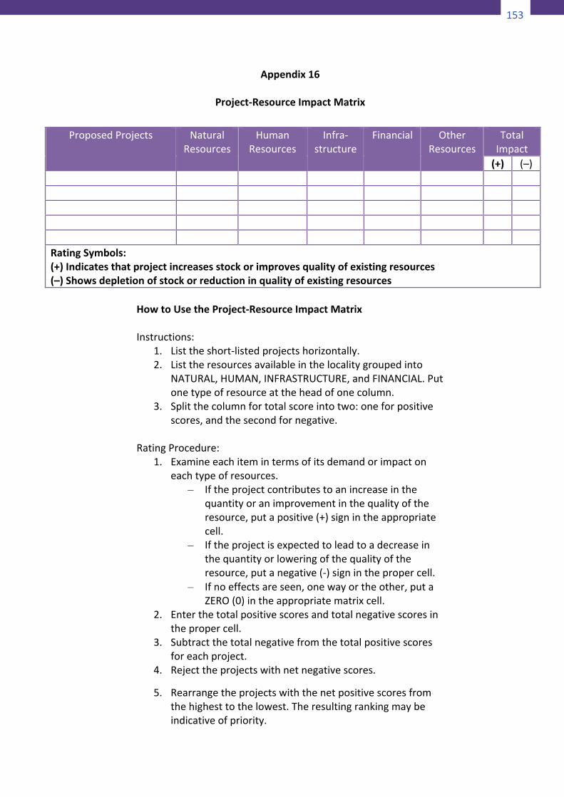
153
154
infrastructure investments, to calculate the regional economicbenefit of parks and to monitor visitor satisfaction. Manyprotected areas are valuable tourist attractions and visitormonitoringprogrammesneedtobeimplemented.Theimpactsofvisitorsatsensitivesitesshouldalsobemeasuredandmonitored.CommunityinventoryUnderstanding the local community and its economic, cultural,demographic,employmentandsocialstructureiscrucial.Muchofthedatamaybeavailablefromgovernment(national,regionalorlocal)statistics.Someinformationcanonlybeobtainedbysurveys(written, interviews, focus groups, etc.). Human uses – such asbusiness and residential development, hunting, fishing, cuttingwood,clearingareasforagricultureandrecreation–needstobeconsidered.Inthecaseofcommunityconservedareas(CCAs)andotherprotectedareasinwhichindigenousandlocalcommunitiesreside, the community’s own understanding of history,biodiversity conservation and sustainable resource utilization iscritical.Socialandland-usehistoryBeing informedabout thehumanor socialhistoryof thearea isinvaluable to protected areamanagers. In combinationwith theenvironmentalhistoryandthecurrentsituation,this informationcanprovideacompletepictureofwhathasoccurredinthearea.For example, the variety of land uses may help to explain thecomposition of the landscape. Like cultural resources, socialhistorycanbeusedtoprovideinterpretationsforvisitors.FinancialmanagementAll management requires effective and transparent financialadministration.Consequently,afinancialaccountingsystemmustbeput inplacewithadequatecollection, recording,analysisandpresentationoffinancialdata–forexample,income,expenditure,inventories, payrolls, reconciliations, assets, balance sheets,profit-and-lossreportsandsoon.
155
Appendix16
Project-ResourceImpactMatrix
HowtoUsetheProject-ResourceImpactMatrixInstructions:
1. Listtheshort-listedprojectshorizontally.2. Listtheresourcesavailableinthelocalitygroupedinto
NATURAL,HUMAN,INFRASTRUCTURE,andFINANCIAL.Putonetypeofresourceattheheadofonecolumn.
3. Splitthecolumnfortotalscoreintotwo:oneforpositivescores,andthesecondfornegative.
RatingProcedure:
1. Examineeachitemintermsofitsdemandorimpactoneachtypeofresources.
– Iftheprojectcontributestoanincreaseinthequantityoranimprovementinthequalityoftheresource,putapositive(+)signintheappropriatecell.
– Iftheprojectisexpectedtoleadtoadecreaseinthequantityorloweringofthequalityoftheresource,putanegative(-)signinthepropercell.
– Ifnoeffectsareseen,onewayortheother,putaZERO(0)intheappropriatematrixcell.
2. Enterthetotalpositivescoresandtotalnegativescoresinthepropercell.
3. Subtractthetotalnegativefromthetotalpositivescoresforeachproject.
4. Rejecttheprojectswithnetnegativescores.
ProposedProjects NaturalResources
HumanResources
Infra-structure
Financial OtherResources
TotalImpact
(+) (–) RatingSymbols:(+)Indicatesthatprojectincreasesstockorimprovesqualityofexistingresources(–)Showsdepletionofstockorreductioninqualityofexistingresources
156
5. Rearrangetheprojectswiththenetpositivescoresfromthehighesttothelowest.Theresultingrankingmaybeindicativeofpriority.
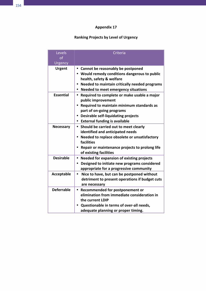
154
157
Appendix17
RankingProjectsbyLevelofUrgency
Levelsof
Urgency
Criteria
Urgent • Cannotbereasonablybepostponed• Wouldremedyconditionsdangeroustopublic
health,safety&welfare• Neededtomaintaincriticallyneededprograms• Neededtomeetemergencysituations
Essential
• Requiredtocompleteormakeusableamajorpublicimprovement
• Requiredtomaintainminimumstandardsaspartofon-goingprograms
• Desirableself-liquidatingprojects• Externalfundingisavailable
Necessary • Shouldbecarriedouttomeetclearlyidentifiedandanticipatedneeds
• Neededtoreplaceobsoleteorunsatisfactoryfacilities
• Repairormaintenanceprojectstoprolonglifeofexistingfacilities
Desirable • Neededforexpansionofexistingprojects• Designedtoinitiatenewprogramsconsidered
appropriateforaprogressivecommunityAcceptable • Nicetohave,butcanbepostponedwithout
detrimenttopresentoperationsifbudgetcutsarenecessary
Deferrable • RecommendedforpostponementoreliminationfromimmediateconsiderationinthecurrentLDIP
• Questionableintermsofover-allneeds,adequateplanningorpropertiming.
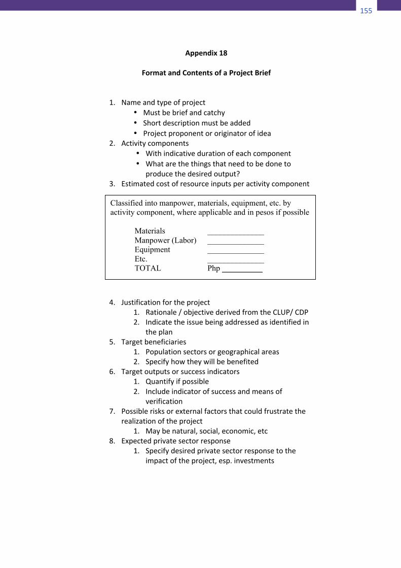
155
157
Appendix17
RankingProjectsbyLevelofUrgency
Levelsof
Urgency
Criteria
Urgent • Cannotbereasonablybepostponed• Wouldremedyconditionsdangeroustopublic
health,safety&welfare• Neededtomaintaincriticallyneededprograms• Neededtomeetemergencysituations
Essential
• Requiredtocompleteormakeusableamajorpublicimprovement
• Requiredtomaintainminimumstandardsaspartofon-goingprograms
• Desirableself-liquidatingprojects• Externalfundingisavailable
Necessary • Shouldbecarriedouttomeetclearlyidentifiedandanticipatedneeds
• Neededtoreplaceobsoleteorunsatisfactoryfacilities
• Repairormaintenanceprojectstoprolonglifeofexistingfacilities
Desirable • Neededforexpansionofexistingprojects• Designedtoinitiatenewprogramsconsidered
appropriateforaprogressivecommunityAcceptable • Nicetohave,butcanbepostponedwithout
detrimenttopresentoperationsifbudgetcutsarenecessary
Deferrable • RecommendedforpostponementoreliminationfromimmediateconsiderationinthecurrentLDIP
• Questionableintermsofover-allneeds,adequateplanningorpropertiming.
158
Appendix18
FormatandContentsofaProjectBrief
1. Nameandtypeofproject• Mustbebriefandcatchy• Shortdescriptionmustbeadded• Projectproponentororiginatorofidea
2. Activitycomponents• Withindicativedurationofeachcomponent• Whatarethethingsthatneedtobedoneto
producethedesiredoutput?3. Estimatedcostofresourceinputsperactivitycomponent
4. Justificationfortheproject1. Rationale/objectivederivedfromtheCLUP/CDP2. Indicatetheissuebeingaddressedasidentifiedin
theplan5. Targetbeneficiaries
1. Populationsectorsorgeographicalareas2. Specifyhowtheywillbebenefited
6. Targetoutputsorsuccessindicators1. Quantifyifpossible2. Includeindicatorofsuccessandmeansof
verification7. Possiblerisksorexternalfactorsthatcouldfrustratethe
realizationoftheproject1. Maybenatural,social,economic,etc
8. Expectedprivatesectorresponse1. Specifydesiredprivatesectorresponsetothe
impactoftheproject,esp.investments
Classified into manpower, materials, equipment, etc. by activity component, where applicable and in pesos if possible Materials ______________ Manpower (Labor) ______________ Equipment ______________ Etc. ______________ TOTAL Php __________
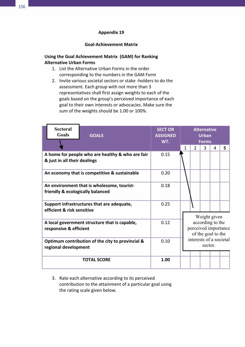
156
159
Appendix19
Goal-AchievementMatrixUsingtheGoalAchievementMatrix(GAM)forRankingAlternativeUrbanForms
1. ListtheAlternativeUrbanFormsintheordercorrespondingtothenumbersintheGAMForm
2. Invitevarioussocietalsectorsorstake-holderstodotheassessment.Eachgroupwithnotmorethan3representativesshallfirstassignweightstoeachofthegoalsbasedonthegroup’sperceivedimportanceofeachgoaltotheirowninterestsoradvocacies.Makesurethesumoftheweightsshouldbe1.00or100%.
GOALS
SECTORASSIGNED
WT.
AlternativeUrbanForms
1 2 3 4 5Ahomeforpeoplewhoarehealthy&whoarefair&justinalltheirdealings
0.15
Aneconomythatiscompetitive&sustainable
0.20
Anenvironmentthatiswholesome,tourist-friendly&ecologicallybalanced
0.18
Supportinfrastructuresthatareadequate,efficient&risksensitive
0.25
Alocalgovernmentstructurethatiscapable,responsive&efficient
0.12
Optimumcontributionofthecitytoprovincial®ionaldevelopment
0.10
TOTALSCORE 1.00
3. Rateeachalternativeaccordingtoitsperceived
contributiontotheattainmentofaparticulargoalusingtheratingscalegivenbelow.
Sectoral Goals
Weight given according to the
perceived importance of the goal to the
interests of a societal sector.
160
4. Multiplytheratingyougavebythecorrespondingweightofthegoalandentertheproduct(score)intheappropriatecell.Aftercompletingonealternativeadditsscoresalgebraicallythenmoveontothenext.
RATINGSCALERateeachurbanformaccordingtoitsperceivedcontributiontotheattainmentofaparticulargoal.3:UrbanFormcontributesgreatlytothefulfilmentofgoal2:UrbanFormcontributesmoderatelytothefulfilmentofgoal1:UrbanFormcontributesslightlytothefulfilmentofgoal0:UrbanFormdoesnotcontributetothefulfilmentofthegoal(1):UrbanFormslightlyinconsistentwiththegoal(2):UrbanFormmoderatelyinconsistentwiththegoal(3):UrbanFormgreatlycontradictsthegoal
GOALS
SECTORASSIGNED
WT.
AlternativeUrbanForms
1 2 3 4 5Ahomeforpeoplewhoarehealthy&whoarefair&justinalltheirdealings
0.15 3
Aneconomythatiscompetitive&sustainable
0.20 3
Anenvironmentthatiswholesome,tourist-friendly&ecologicallybalanced
0.18 1
Supportinfrastructuresthatareadequate,efficient&risksensitive
0.25 2
Alocalgovernmentstructurethatiscapable,responsive&efficient
0.12 1
Optimumcontributionofthecitytoprovincial®ionaldevelopment
0.10 0
TOTALSCORE 1.00
Weight given according to the
perceived importance of the goal to the
interests of a societal sector.
Sectoral Goals
This is the rating of the project vis-a-vis the goal. (See Rating Scale)
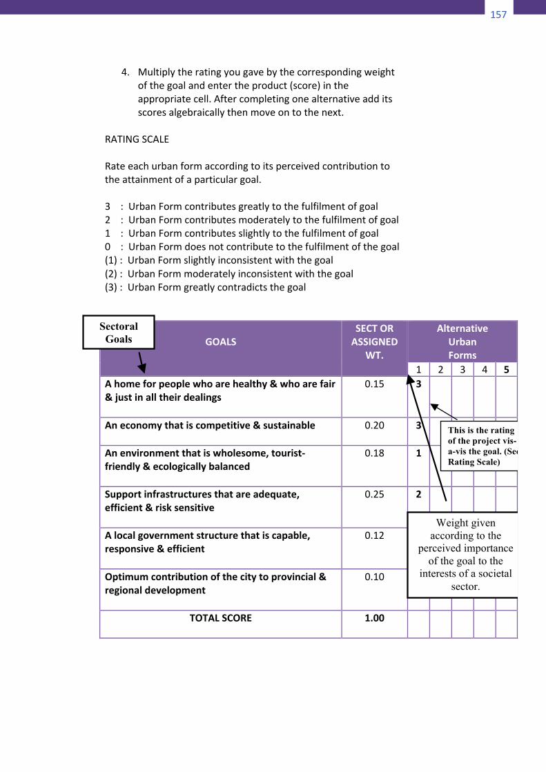
157
160
4. Multiplytheratingyougavebythecorrespondingweightofthegoalandentertheproduct(score)intheappropriatecell.Aftercompletingonealternativeadditsscoresalgebraicallythenmoveontothenext.
RATINGSCALERateeachurbanformaccordingtoitsperceivedcontributiontotheattainmentofaparticulargoal.3:UrbanFormcontributesgreatlytothefulfilmentofgoal2:UrbanFormcontributesmoderatelytothefulfilmentofgoal1:UrbanFormcontributesslightlytothefulfilmentofgoal0:UrbanFormdoesnotcontributetothefulfilmentofthegoal(1):UrbanFormslightlyinconsistentwiththegoal(2):UrbanFormmoderatelyinconsistentwiththegoal(3):UrbanFormgreatlycontradictsthegoal
GOALS
SECTORASSIGNED
WT.
AlternativeUrbanForms
1 2 3 4 5Ahomeforpeoplewhoarehealthy&whoarefair&justinalltheirdealings
0.15 3
Aneconomythatiscompetitive&sustainable
0.20 3
Anenvironmentthatiswholesome,tourist-friendly&ecologicallybalanced
0.18 1
Supportinfrastructuresthatareadequate,efficient&risksensitive
0.25 2
Alocalgovernmentstructurethatiscapable,responsive&efficient
0.12 1
Optimumcontributionofthecitytoprovincial®ionaldevelopment
0.10 0
TOTALSCORE 1.00
Weight given according to the
perceived importance of the goal to the
interests of a societal sector.
Sectoral Goals
This is the rating of the project vis-a-vis the goal. (See Rating Scale)
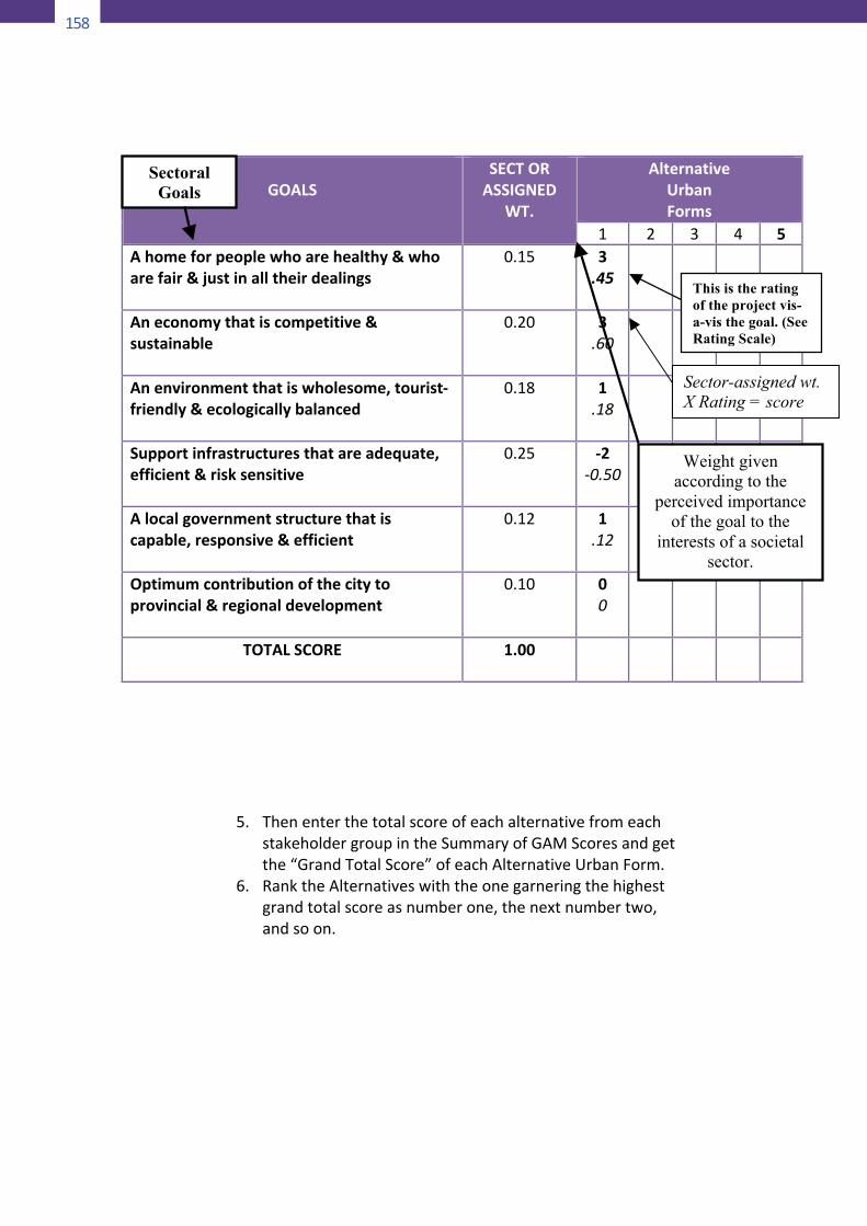
158
161
5. ThenenterthetotalscoreofeachalternativefromeachstakeholdergroupintheSummaryofGAMScoresandgetthe“GrandTotalScore”ofeachAlternativeUrbanForm.
6. RanktheAlternativeswiththeonegarneringthehighestgrandtotalscoreasnumberone,thenextnumbertwo,andsoon.
GOALS
SECTORASSIGNED
WT.
AlternativeUrbanForms
1 2 3 4 5Ahomeforpeoplewhoarehealthy&whoarefair&justinalltheirdealings
0.15 3.45
Aneconomythatiscompetitive&sustainable
0.20 3.60
Anenvironmentthatiswholesome,tourist-friendly&ecologicallybalanced
0.18 1.18
Supportinfrastructuresthatareadequate,efficient&risksensitive
0.25 -2-0.50
Alocalgovernmentstructurethatiscapable,responsive&efficient
0.12 1.12
Optimumcontributionofthecitytoprovincial®ionaldevelopment
0.10 00
TOTALSCORE 1.00
Sectoral Goals
Weight given according to the
perceived importance of the goal to the
interests of a societal sector.
This is the rating of the project vis-a-vis the goal. (See Rating Scale)
Sector-assigned wt. X Rating = score
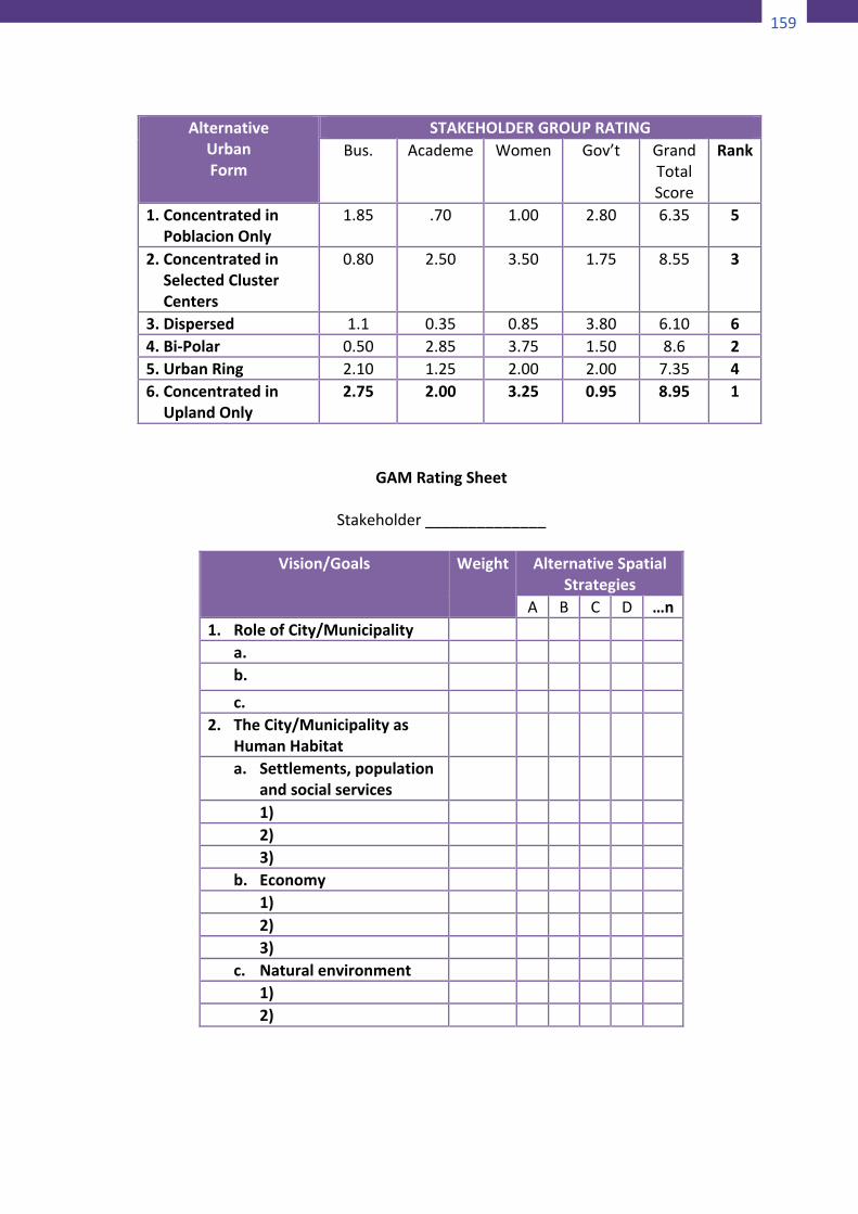
159
161
5. ThenenterthetotalscoreofeachalternativefromeachstakeholdergroupintheSummaryofGAMScoresandgetthe“GrandTotalScore”ofeachAlternativeUrbanForm.
6. RanktheAlternativeswiththeonegarneringthehighestgrandtotalscoreasnumberone,thenextnumbertwo,andsoon.
GOALS
SECTORASSIGNED
WT.
AlternativeUrbanForms
1 2 3 4 5Ahomeforpeoplewhoarehealthy&whoarefair&justinalltheirdealings
0.15 3.45
Aneconomythatiscompetitive&sustainable
0.20 3.60
Anenvironmentthatiswholesome,tourist-friendly&ecologicallybalanced
0.18 1.18
Supportinfrastructuresthatareadequate,efficient&risksensitive
0.25 -2-0.50
Alocalgovernmentstructurethatiscapable,responsive&efficient
0.12 1.12
Optimumcontributionofthecitytoprovincial®ionaldevelopment
0.10 00
TOTALSCORE 1.00
Sectoral Goals
Weight given according to the
perceived importance of the goal to the
interests of a societal sector.
This is the rating of the project vis-a-vis the goal. (See Rating Scale)
Sector-assigned wt. X Rating = score
162
GAMRatingSheet
Stakeholder______________
Vision/Goals Weight AlternativeSpatialStrategies
A B C D …n1. RoleofCity/Municipality
a. b.
c. 2. TheCity/Municipalityas
HumanHabitat
a. Settlements,populationandsocialservices
1) 2) 3)
b. Economy 1) 2) 3)
c. Naturalenvironment 1) 2)
AlternativeUrbanForm
STAKEHOLDERGROUPRATINGBus. Academe Women Gov’t Grand
TotalScore
Rank
1. ConcentratedinPoblacionOnly
1.85 .70 1.00 2.80 6.35 5
2. ConcentratedinSelectedClusterCenters
0.80 2.50 3.50 1.75 8.55 3
3. Dispersed 1.1 0.35 0.85 3.80 6.10 64. Bi-Polar 0.50 2.85 3.75 1.50 8.6 25. UrbanRing 2.10 1.25 2.00 2.00 7.35 46. Concentratedin
UplandOnly2.75 2.00 3.25 0.95 8.95 1
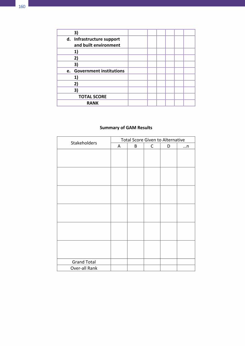
160
163
3) d. Infrastructuresupport
andbuiltenvironment
1) 2) 3)
e. Governmentinstitutions 1) 2) 3)
TOTALSCORE RANK
SummaryofGAMResults
Stakeholders TotalScoreGiventoAlternativeA B C D …n
GrandTotal Over-allRank
161
163
3) d. Infrastructuresupport
andbuiltenvironment
1) 2) 3)
e. Governmentinstitutions 1) 2) 3)
TOTALSCORE RANK
SummaryofGAMResults
Stakeholders TotalScoreGiventoAlternativeA B C D …n
GrandTotal Over-allRank
164
Appendix20
PreparingProtectedAreaManagementPlans(AdaptedfromMichaelLockwood)
EstablishparticipatorymechanismsandstructuresThetypeanddegreeofpublicparticipationadoptedinaplanningprojectwill dependupon the governance arrangements and theapproach taken by the planner and management agency.Stakeholdersmay come together in a formal setting, such as anadvisorycommitteemeeting,oraplannermayreceiveininformaldeputationorphonecallfromaninterestedandsometimesirateindividual. In many planning projects, the planner is in thepositionofbeinga facilitatoror leaderofagroupofpeople.Forexample, the plannermight be the convener of a departmentalsteeringcommitteesetuptodirecttheplanningproject,aswellas an advisory committee made up of representatives of keyinterestgroups.Groupsand individualswhomightbe included in aparticipationprogrammecanbedrawnfromwithinthedepartmentitself,fromother government departments and agencies, and from thegeneralpublic.CollectrelevantdataHigh-qualityinformationisanimportantbasisformanyaspectsofprotected area management, and area management planning isnoexception. Incorrect, insufficientor inadequate resourcedatacan severely hamper the effectiveness and quality of amanagement plan.However, complete knowledge of a resourceis,of course,unobtainable.Collectingandcompiling informationtakes time and costs money, and both of these factors usuallyplacestringent limitsonthedatacollectioneffort. It isthereforeparticularlyimportanttoconcentrateoncollectingrelevantdata.Planning is not about collecting information for its own sake.Comprehensivestatisticsonvisitoractivitiesmaybeessentialforan area with a significant recreation component, while anotherarea may require only general impressionistic information onvisitoractivities.
162
165
Afterpursuingallpotentialsourcesofinformation,aplannermayfind that a key area has not been covered adequately. Forexample, thedistributionand requirementsofendangeredplantspeciesrecordedintheplanningareamanynotbeknown.Inthiscase,theplannerhastwooptions.The required information can be gathered in the course of theplanning projects so that it is available to assist managementdecisionscontainedintheplan,ortheplancansimplyspecifyanactioninrelationtothecollectionofthisinformation.The first option is by far superior because it will enable amanagement decision to be made regarding (in this case) theendangered species, which can then be integrated within theplanningprocess.Thismeans that therecanbepublic inputanddiscussionoftheissue,theoptionsformanagingthespecies,anddecisionsregardingthepreferredmanagementactions.However,time and money may preclude selection of this option and theplannermaysimplehavetoincludearecommendationintheplanregardingfutureresearchonthespecies.Insomecases,itmaybeappropriatetopublishtheresourcedatacollectedasaseparatedocument—aresourceinventory.Thiscanbe particularly valuable in two respects. First, if there has beenverylittlepublishedinformationavailableontheplanningareaitgivesinterestedpartiesaccesstorelevantinformationearlyintheplanning process. This can considerably improve the quality andutility of input received from people and groups outside theplanningteam.Second,itcanhelptheplannertoavoidclutteringup the management plan with a large volume of backgroundinformation.Anexcessofsuchinformationcandistractthereaderfrom the plan itself and make the document too long andunwieldly.IdentifyandanalyzetheissuesThe process of compiling a resource inventory should provide agood basis for identifying and analyzing problems and issuesassociated with the planning area. The public participationcomponentoftheplanningprocessisalsousedtoidentifyissues.Issuesmayinvolveconflictsbetween:• varioususesandconservationofnaturalvalues—forexample,
between cattle grazing and conservation of a significant
163
165
Afterpursuingallpotentialsourcesofinformation,aplannermayfind that a key area has not been covered adequately. Forexample, thedistributionand requirementsofendangeredplantspeciesrecordedintheplanningareamanynotbeknown.Inthiscase,theplannerhastwooptions.The required information can be gathered in the course of theplanning projects so that it is available to assist managementdecisionscontainedintheplan,ortheplancansimplyspecifyanactioninrelationtothecollectionofthisinformation.The first option is by far superior because it will enable amanagement decision to be made regarding (in this case) theendangered species, which can then be integrated within theplanningprocess.Thismeans that therecanbepublic inputanddiscussionoftheissue,theoptionsformanagingthespecies,anddecisionsregardingthepreferredmanagementactions.However,time and money may preclude selection of this option and theplannermaysimplehavetoincludearecommendationintheplanregardingfutureresearchonthespecies.Insomecases,itmaybeappropriatetopublishtheresourcedatacollectedasaseparatedocument—aresourceinventory.Thiscanbe particularly valuable in two respects. First, if there has beenverylittlepublishedinformationavailableontheplanningareaitgivesinterestedpartiesaccesstorelevantinformationearlyintheplanning process. This can considerably improve the quality andutility of input received from people and groups outside theplanningteam.Second,itcanhelptheplannertoavoidclutteringup the management plan with a large volume of backgroundinformation.Anexcessofsuchinformationcandistractthereaderfrom the plan itself and make the document too long andunwieldly.IdentifyandanalyzetheissuesThe process of compiling a resource inventory should provide agood basis for identifying and analyzing problems and issuesassociated with the planning area. The public participationcomponentoftheplanningprocessisalsousedtoidentifyissues.Issuesmayinvolveconflictsbetween:• varioususesandconservationofnaturalvalues—forexample,
between cattle grazing and conservation of a significant
166
species, or building of a major visitor access route andpreservationofscenicquality;
• oneresourcecomponentandanother—forexample,betweenanintroducedspeciesandanativeone;
• various uses and the resource upon which they depend—forexample, the quality of a bush camping experience can bediminished by problems of vegetation depletion, rubbish,disposal of toilet wastes and so on that are the result ofcamping,and
• oneuseandanother—forexample,fisherfolkandwater-sportusers; forest-dwelling peoples and wildlife tourists;bushwalkers and trail bike riders; or water-skiers andswimmers.
Classifying issues according to this framework can assist theplannerinunderstandingthenatureandcontextoftheissue.Thiscan be the first step in identifying the underlying cause of theissue or problem. In addition, tackling a problem involving tworesourcecomponentsislikelytorequireaverydifficultapproachincomparisontooneinvolvingtwoconflictinguses.EstablishgoalsandobjectivesA goal is a general statement of ends. It is not necessarilyachievableintheplanningperiod,butindicatesthebroadendstowhichmanagementaspires.Examplesofgoalsthatmightappearinaprotectedareamanagementplanareto:• conservenativeplantsandanimals;• secureaculturallyimportantsiteorasiteofcriticallivelihood
importance;• providearangeofrecreationopportunities;and• controlpestplantsandanimals.Goals, because of their very general nature, are by themselvesinsufficient for directing management. However, it is stillimportant to specify these broad statements of direction in amanagementplan.An objective is a statement of realistic,measurable and specificends to be achievedwithin a specific period of time.Objectivesarerequiredforeffectiveevaluationofaplansinceifitisunclearwhataplanintendstoachieve,itisnotpossibletodetermineits

164
167
success or failure. Without objectives, a manager cannot knowwhen a particular action achieved the desired result (andtherefore move on to achieving other objectives). Nor can themanagerdiscoverifaparticularactionis,infact,notachievingthedesired result, and whether another action should be triedinstead.Ideally,anobjectiveshouldbe:• specific;• clearlystated;• measurable;• realistic;and• whereappropriate,timelimited.
Developoptions(actions)forachievingobjectivesOncegoalsandspecificobjectiveshavebeenestablishedforeachmanagement issue, a plannermust explore the possible optionsforachievingtheseobjectives.Someoptionswillbeevidenttotheplanning team from their own professional experience andknowledge of the planning area. Others may be generatedthroughstakeholderandagencystaffparticipationintheplanningprocess.Ausefulwayofgettingalloftheseideasdownonpaperistoholda‘brainstorming’session.SelectactionsOnce the range of possible options for achieving each objectivehasbeenestablished,somebasisisrequiredforselectingthebestoption or combination of options. There is a wide range ofmethodsthatcouldbeusedtotesttheoptions:• professionaljudgement;• dialogueinvolvingplannersandstakeholdersthroughinformal
discussion or formal proceedings, such as enquiries orconferences;and
• systematic application of procedures such as benefit-costanalysis (BCA), multi-criteria analysis, impact assessment orvoting.
165
167
success or failure. Without objectives, a manager cannot knowwhen a particular action achieved the desired result (andtherefore move on to achieving other objectives). Nor can themanagerdiscoverifaparticularactionis,infact,notachievingthedesired result, and whether another action should be triedinstead.Ideally,anobjectiveshouldbe:• specific;• clearlystated;• measurable;• realistic;and• whereappropriate,timelimited.
Developoptions(actions)forachievingobjectivesOncegoalsandspecificobjectiveshavebeenestablishedforeachmanagement issue, a plannermust explore the possible optionsforachievingtheseobjectives.Someoptionswillbeevidenttotheplanning team from their own professional experience andknowledge of the planning area. Others may be generatedthroughstakeholderandagencystaffparticipationintheplanningprocess.Ausefulwayofgettingalloftheseideasdownonpaperistoholda‘brainstorming’session.SelectactionsOnce the range of possible options for achieving each objectivehasbeenestablished,somebasisisrequiredforselectingthebestoption or combination of options. There is a wide range ofmethodsthatcouldbeusedtotesttheoptions:• professionaljudgement;• dialogueinvolvingplannersandstakeholdersthroughinformal
discussion or formal proceedings, such as enquiries orconferences;and
• systematic application of procedures such as benefit-costanalysis (BCA), multi-criteria analysis, impact assessment orvoting.
168
ZoningZoningisatechniquethatinvolvesspatiallyorganizingaplanningarea to facilitate the achievement of management goals and/orobjectives. Zoning can direct management towards achievingspecificobjectivesincertainsub-areaintheoverallplanningarea.Itcanalsoprovidethebasis forpartitioningtheplanningarea inordertoseparateincompatibleusesandtoexcludeinappropriateusesfromcertainareas.Ideally, the zoning scheme should be developed from a widerangeofspatialresourceinformation,including:• landcapabilityfactors,suchasslope,soiltypeandhydrology;• ageneraldescriptionofvegetationcommunities;• sitesofbotanicalandzoologicalsignificance;• sitesofculturalandhistoricalsignificance;• landscapevalues;• recreationactivitiesandopportunities;• currentlanduses;• timber and non-timber forest resources (for a forest
managementplan);and• managementdecisionsregardinglanduse.ImplementtheplanAs noted earlier in ‘Approaches to planning’, effectiveimplementation isaproblemthathas longplaguedtheplanningprocess. It is important that in the effort of developing andcompiling a management plan, linkages to the implementationphase arenot neglected. Processesmust be in place todevelopdetailed budgets and works programmes based on actionsspecified in the management plan. Such supporting documentsindicate the allocation of time, staff and money required toaccomplish each task. Works programmes detail who will becarryingoutwhattasksonwhatday.RevieweffectivenessofactionsinachievingobjectivesMonitoring the consequences of actions recommended in amanagement plan enables a planner to determine whether theactions are, in fact, achieving the objectives set out in the plan.Once the actions have been completed and the corresponding
169
action achieved, management can proceed to deal with a newobjective. If theaction isnotmakingadequateprogress towardsachieving the related objective, then a new action or series ofactionsmayneedtobedeveloped.
166
170
Appendix21
StagesofSystematicConservationPlanning(FromSahotraSarkar)
DelineatetheplanningareaStakeholders must explicitly discuss the precise geographicalboundaries of the planning region at the beginning of anyplanning exercise. Different stakeholders may have differentpreferences for the boundaries of the planning unit. (Thus thechoiceoftheplanningregioninteractswiththeidentityandviewsof the stakeholders. The boundaries of the planning region willtypically have a strong influence on what types of datacompilationandanalysismaybefeasible.)IdentifyallstakeholdersConservation plans have little chance of successfulimplementation if they do notmanage to negotiate successfullythe socio-political issues relevant to the planning region,incorporate constraints, and take advantage of opportunities.Prospects for successful implementation are enhanced if all therelevant agents participate in the planning process from thebeginning.Thestakeholderswillalsohavearoleinimplementingandmonitoringaconservationplanat later stages.Stakeholdersincludebiologicalandotherexperts.Obviously,thedelineationofa planning region depends on the expert stakeholders and thechoiceoftheplanningregion influenceswhoqualifiesasexpertsand other stakeholders. Though it is often ignored in practice,determiningwhoisalegitimatestakeholderrequiresattentiontonormativeissues.CompileandassessdataConservationplanningrequiresbothbiologicalandsocio-politicaldata.Sufficient resourcesare typicallynotavailable tocollectallthedatathatwouldbeuseful.Datacollection,forinstancethoughsurveys,shouldbecost-efficientandfocusedonthoseparametersthat are the most important. Increasingly, planning is becomingreliant on publicly available resources such as the GlobalBiodiversityInformationFacility(GBIF)andremotelysenseddata.What data aremost relevant is determined by the study regionandtheplanninggoalsandobjectives.
167
170
Appendix21
StagesofSystematicConservationPlanning(FromSahotraSarkar)
DelineatetheplanningareaStakeholders must explicitly discuss the precise geographicalboundaries of the planning region at the beginning of anyplanning exercise. Different stakeholders may have differentpreferences for the boundaries of the planning unit. (Thus thechoiceoftheplanningregioninteractswiththeidentityandviewsof the stakeholders. The boundaries of the planning region willtypically have a strong influence on what types of datacompilationandanalysismaybefeasible.)IdentifyallstakeholdersConservation plans have little chance of successfulimplementation if they do notmanage to negotiate successfullythe socio-political issues relevant to the planning region,incorporate constraints, and take advantage of opportunities.Prospects for successful implementation are enhanced if all therelevant agents participate in the planning process from thebeginning.Thestakeholderswillalsohavearoleinimplementingandmonitoringaconservationplanat later stages.Stakeholdersincludebiologicalandotherexperts.Obviously,thedelineationofa planning region depends on the expert stakeholders and thechoiceoftheplanningregion influenceswhoqualifiesasexpertsand other stakeholders. Though it is often ignored in practice,determiningwhoisalegitimatestakeholderrequiresattentiontonormativeissues.CompileandassessdataConservationplanningrequiresbothbiologicalandsocio-politicaldata.Sufficient resourcesare typicallynotavailable tocollectallthedatathatwouldbeuseful.Datacollection,forinstancethoughsurveys,shouldbecost-efficientandfocusedonthoseparametersthat are the most important. Increasingly, planning is becomingreliant on publicly available resources such as the GlobalBiodiversityInformationFacility(GBIF)andremotelysenseddata.What data aremost relevant is determined by the study regionandtheplanninggoalsandobjectives.
171
TreatdataandconstructmodelsasnecessaryAlmostalldatahaveinbuiltspatialandotherbiasesthathavetoberemovedthroughstatisticalrefinementandmodeling.Inmanyplanning contexts, species’ geographicaldistributionshave tobemodeled from sparse opportunistic records and modeledenvironmental data. An extensive methodology has beendevelopedforthispurpose.IdentifyandevaluatebiodiversityconstituentsandsurrogatesCare must be taken to ensure that biodiversity is appropriatelyrepresented and quantified. First, appropriate constituents ofbiodiversity must be selected by stakeholders to represent themost important components of the regional biota that deserveconservation attention. If full distributional information on thebiodiversityconstituentsisnotobtainable,asistypicallythecase,surrogatesforthemmustbeidentified.SetexplicitbiodiversitygoalsandtargetsIt is crucial to be explicit about what constitutes adequatebiodiversity protection. Quantitative targets of representationmust be set for all biodiversity surrogates. Spatial configurationandothergoalsmustsimilarlybeexplicitlyspecified—thesegoalsaretypicallyimposedtoenhancethepersistenceofbiodiversityinaconservationareanetwork.ReviewexistingconservationareasforperformancewithrespecttotargetsPrioritizeadditionalareasforconservationmanagementTheexistingprotectedareas,ifthereareany,mustbeanalyzedtodetermine theextent towhich theyalready satisfy the specifiedgoals and targets. New areas must be prioritized so that thespecified goals and targets may be met when these areas areincludedinanexpandedconservationareanetwork.Theproblemis one of constrained optimization (as discussed in the textbelow). This stage may involve only achieving representationtargets or may also incorporate other criteria, both spatial andsocio-political. If these other criteria are being incorporated,multi-criteriaanalysisbecomesrelevant.

168
172
AssessbiodiversityconstituentandselectedareavulnerabilitiesA selected areamay itself be vulnerable, inwhich case there isusuallyapoorprognosisforall itsbiodiversityconstituents.Suchvulnerability can arise from socio-political factors (for instance,developmentthreat),existingecologicalfactors,orglobalchangefactors (suchas climate change).Alternatively,only someof theconstituentsintheareamaybevulnerablebecauseofthequalityofthehabitat.Ifthoseconstituentsrequirethatareatomeettherelevant goals and targets, then the area itself should beconsidered vulnerable. Assessing vulnerability is typically verydifficult. This part of systematic conservation planning remainspoorlydeveloped.RefinethenetworkofselectedareasIfvulnerableareasarenotentirelyirreplaceable,agoodstrategyistoexcludethemfromnominalconservationareanetworksandrepeat the area prioritization process. The vulnerability analysismust then be performed again, and the entire cycle must bereiterated until all goals and targets are met in a “safe” set ofpotentialconservationareas.Carryoutmulti-criteriaanalysisIf not all relevant criteria were incorporated at the stage ofprioritizingnewareas,amulti-criteriaanalysismustbeperformedto ensure that these criteria are incorporated into the design.Typically, multi-criteria analysis is done by generating a largenumber of “solutions” or potential conservation area networks,each of which satisfies the criteria that were used for areaprioritization.Thesesolutionsarenotevaluatedandrankedusingtheothercriteria.ImplementconservationplanA nominal conservation area network must be implemented bydevising appropriate management plans and then ensuring thatthey are put into practice. Implementation plans must takerelevant contextual issues intoaccount.While scientific analysescontribute towards devising a plan, implementation is almostentirelyasocio-politicalprocess.
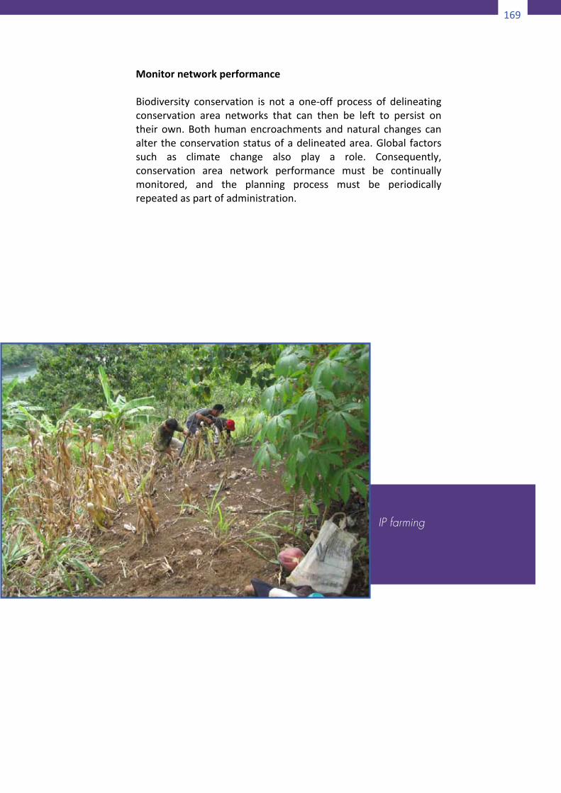
169
172
AssessbiodiversityconstituentandselectedareavulnerabilitiesA selected areamay itself be vulnerable, inwhich case there isusuallyapoorprognosisforall itsbiodiversityconstituents.Suchvulnerability can arise from socio-political factors (for instance,developmentthreat),existingecologicalfactors,orglobalchangefactors (suchas climate change).Alternatively,only someof theconstituentsintheareamaybevulnerablebecauseofthequalityofthehabitat.Ifthoseconstituentsrequirethatareatomeettherelevant goals and targets, then the area itself should beconsidered vulnerable. Assessing vulnerability is typically verydifficult. This part of systematic conservation planning remainspoorlydeveloped.RefinethenetworkofselectedareasIfvulnerableareasarenotentirelyirreplaceable,agoodstrategyistoexcludethemfromnominalconservationareanetworksandrepeat the area prioritization process. The vulnerability analysismust then be performed again, and the entire cycle must bereiterated until all goals and targets are met in a “safe” set ofpotentialconservationareas.Carryoutmulti-criteriaanalysisIf not all relevant criteria were incorporated at the stage ofprioritizingnewareas,amulti-criteriaanalysismustbeperformedto ensure that these criteria are incorporated into the design.Typically, multi-criteria analysis is done by generating a largenumber of “solutions” or potential conservation area networks,each of which satisfies the criteria that were used for areaprioritization.Thesesolutionsarenotevaluatedandrankedusingtheothercriteria.ImplementconservationplanA nominal conservation area network must be implemented bydevising appropriate management plans and then ensuring thatthey are put into practice. Implementation plans must takerelevant contextual issues intoaccount.While scientific analysescontribute towards devising a plan, implementation is almostentirelyasocio-politicalprocess.
173
MonitornetworkperformanceBiodiversity conservation is not a one-off process of delineatingconservation area networks that can then be left to persist ontheirown.Bothhumanencroachmentsandnatural changes canalter theconservationstatusofadelineatedarea.Global factorssuch as climate change also play a role. Consequently,conservation area network performance must be continuallymonitored, and the planning process must be periodicallyrepeatedaspartofadministration.
IP farming
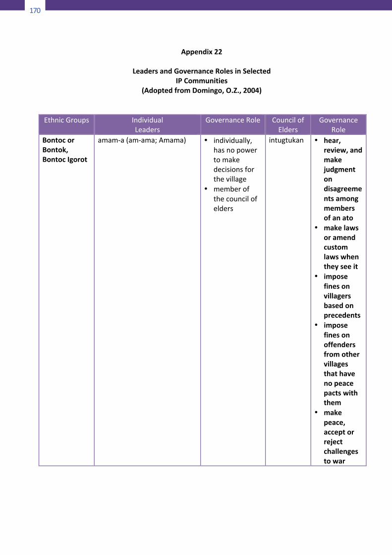
170
174
Appendix22
LeadersandGovernanceRolesinSelectedIPCommunities
(AdoptedfromDomingo,O.Z.,2004)
EthnicGroups IndividualLeaders
GovernanceRole CouncilofElders
GovernanceRole
BontocorBontok,BontocIgorot
amam-a(am-ama;Amama) • individually,hasnopowertomakedecisionsforthevillage
• memberofthecouncilofelders
intugtukan • hear,review,andmakejudgmentondisagreementsamongmembersofanato
• makelawsoramendcustomlawswhentheyseeit
• imposefinesonvillagersbasedonprecedents
• imposefinesonoffendersfromothervillagesthathavenopeacepactswiththem
• makepeace,acceptorrejectchallengestowar
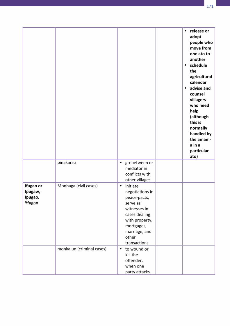
171
174
Appendix22
LeadersandGovernanceRolesinSelectedIPCommunities
(AdoptedfromDomingo,O.Z.,2004)
EthnicGroups IndividualLeaders
GovernanceRole CouncilofElders
GovernanceRole
BontocorBontok,BontocIgorot
amam-a(am-ama;Amama) • individually,hasnopowertomakedecisionsforthevillage
• memberofthecouncilofelders
intugtukan • hear,review,andmakejudgmentondisagreementsamongmembersofanato
• makelawsoramendcustomlawswhentheyseeit
• imposefinesonvillagersbasedonprecedents
• imposefinesonoffendersfromothervillagesthathavenopeacepactswiththem
• makepeace,acceptorrejectchallengestowar
175
• releaseoradoptpeoplewhomovefromoneatotoanother
• scheduletheagriculturalcalendar
• adviseandcounselvillagerswhoneedhelp(althoughthisisnormallyhandledbytheamam-ainaparticularato)
pinakarsu • go-betweenormediatorinconflictswithothervillages
IfugaoorIpugaw,Ipugao,Yfugao
Monbaga(civilcases) • initiatenegotiationsinpeace-pacts,serveaswitnessesincasesdealingwithproperty,mortgages,marriage,andothertransactions
monkalun(criminalcases) • towoundorkilltheoffender,whenonepartyattacks
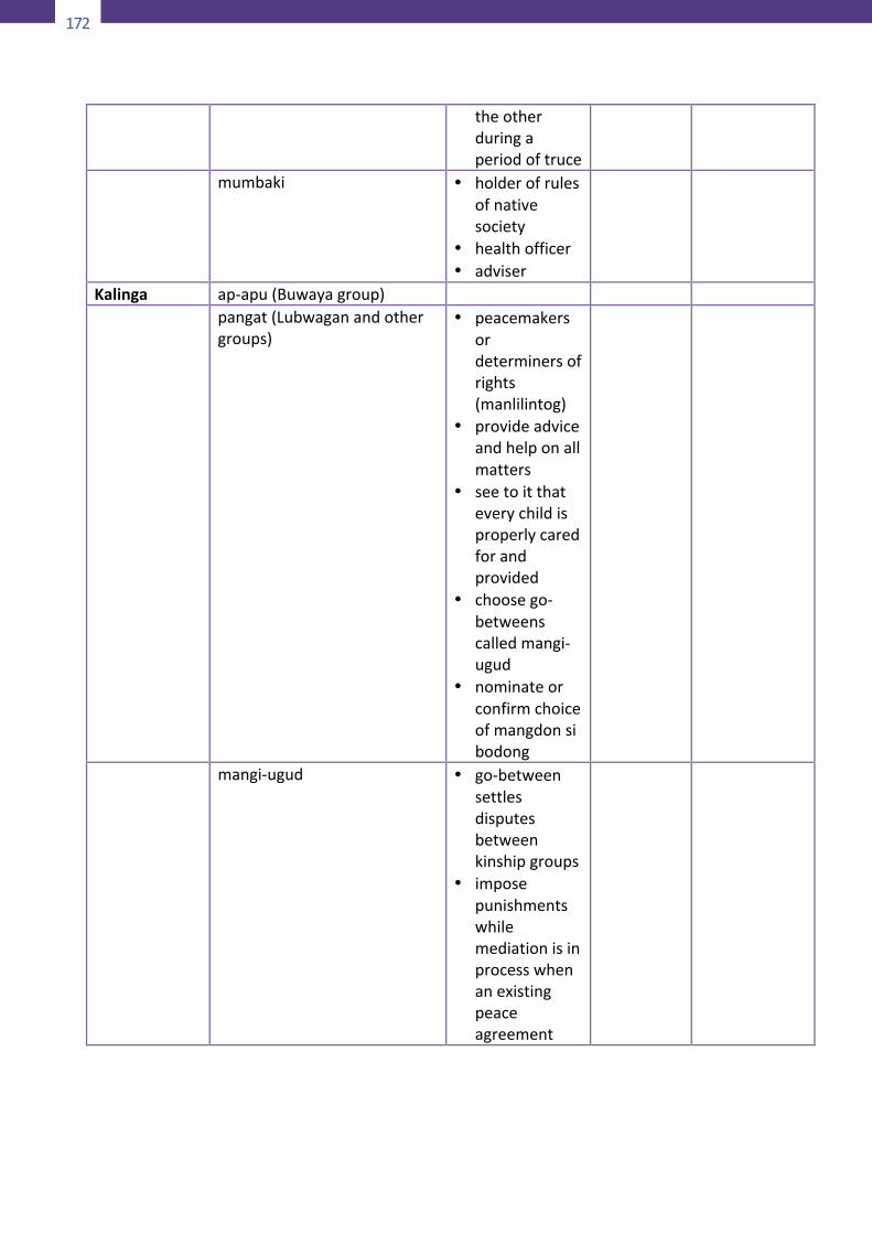
172
176
theotherduringaperiodoftruce
mumbaki • holderofrulesofnativesociety
• healthofficer• adviser
Kalinga ap-apu(Buwayagroup) pangat(Lubwaganandother
groups)• peacemakers
ordeterminersofrights(manlilintog)
• provideadviceandhelponallmatters
• seetoitthateverychildisproperlycaredforandprovided
• choosego-betweenscalledmangi-ugud
• nominateorconfirmchoiceofmangdonsibodong
mangi-ugud • go-betweensettlesdisputesbetweenkinshipgroups
• imposepunishmentswhilemediationisinprocesswhenanexistingpeaceagreement
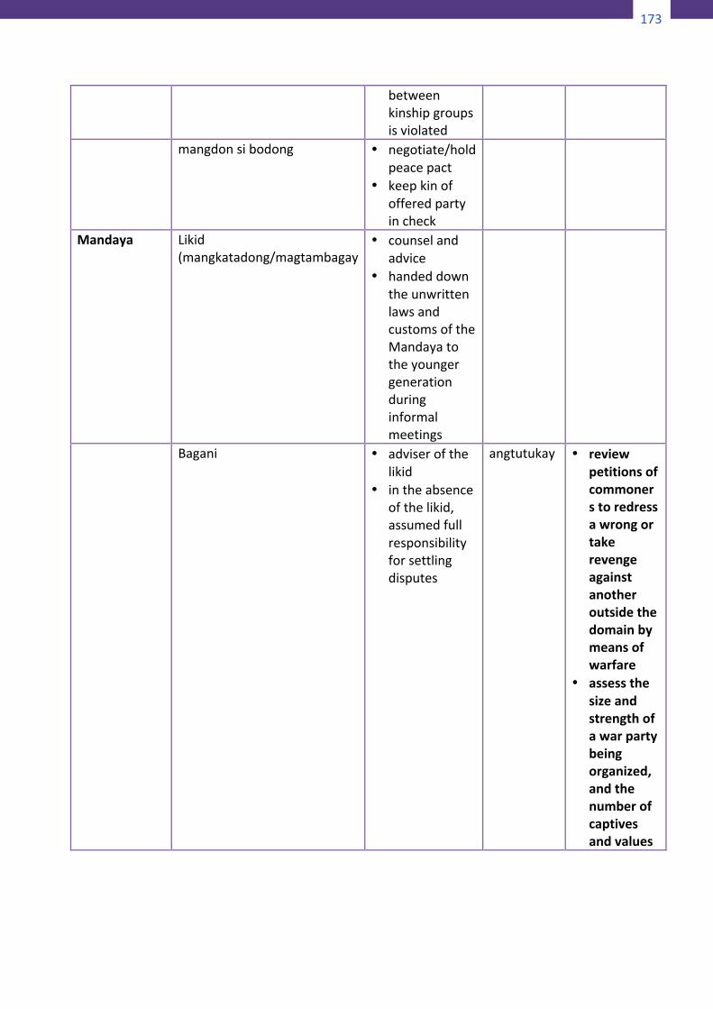
173
176
theotherduringaperiodoftruce
mumbaki • holderofrulesofnativesociety
• healthofficer• adviser
Kalinga ap-apu(Buwayagroup) pangat(Lubwaganandother
groups)• peacemakers
ordeterminersofrights(manlilintog)
• provideadviceandhelponallmatters
• seetoitthateverychildisproperlycaredforandprovided
• choosego-betweenscalledmangi-ugud
• nominateorconfirmchoiceofmangdonsibodong
mangi-ugud • go-betweensettlesdisputesbetweenkinshipgroups
• imposepunishmentswhilemediationisinprocesswhenanexistingpeaceagreement
177
betweenkinshipgroupsisviolated
mangdonsibodong • negotiate/holdpeacepact
• keepkinofofferedpartyincheck
Mandaya Likid(mangkatadong/magtambagay
• counselandadvice
• handeddowntheunwrittenlawsandcustomsoftheMandayatotheyoungergenerationduringinformalmeetings
Bagani • adviserofthelikid
• intheabsenceofthelikid,assumedfullresponsibilityforsettlingdisputes
angtutukay • reviewpetitionsofcommonerstoredressawrongortakerevengeagainstanotheroutsidethedomainbymeansofwarfare
• assessthesizeandstrengthofawarpartybeingorganized,andthenumberofcaptivesandvalues

174
178
tobetakenup
• acquireadditionalchoiceforestareas
• hear,arbitrate,andsettleallintradomaindisputesarisingfromtheft,adultery,violence,rape,murder,etc.
• selectabaganisuccessoramongthesonsofthebagani’sfirstwifeifthepresentwarriorchiefisunabletoruleorhadpassedaway
• transmitthedemands,needs,andgrievancesofcommonerstotheruling
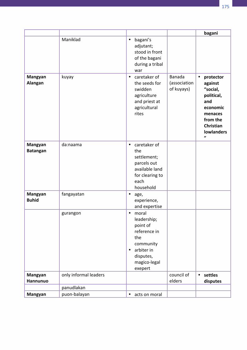
175
178
tobetakenup
• acquireadditionalchoiceforestareas
• hear,arbitrate,andsettleallintradomaindisputesarisingfromtheft,adultery,violence,rape,murder,etc.
• selectabaganisuccessoramongthesonsofthebagani’sfirstwifeifthepresentwarriorchiefisunabletoruleorhadpassedaway
• transmitthedemands,needs,andgrievancesofcommonerstotheruling
179
bagani Maniklad • bagani’s
adjutant;stoodinfrontofthebaganiduringatribalwar
MangyanAlangan
kuyay • caretakeroftheseedsforswiddenagricultureandpriestatagriculturalrites
Banada(associationofkuyays)
• protectoragainst“social,political,andeconomicmenacesfromtheChristianlowlanders”
MangyanBatangan
da:naama • caretakerofthesettlement;parcelsoutavailablelandforclearingtoeachhousehold
MangyanBuhid
fangayatan • age,experience,andexpertise
gurangon • moralleadership;pointofreferenceinthecommunity
• arbiterindisputes,magico-legalexepert
MangyanHannunuo
onlyinformalleaders councilofelders
• settlesdisputes
panudlakan Mangyan puon-balayan • actsonmoral
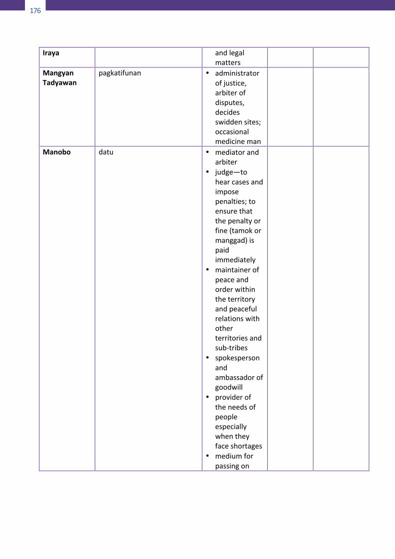
176
180
Iraya andlegalmatters
MangyanTadyawan
pagkatifunan • administratorofjustice,arbiterofdisputes,decidesswiddensites;occasionalmedicineman
Manobo datu • mediatorandarbiter
• judge—tohearcasesandimposepenalties;toensurethatthepenaltyorfine(tamokormanggad)ispaidimmediately
• maintainerofpeaceandorderwithintheterritoryandpeacefulrelationswithotherterritoriesandsub-tribes
• spokespersonandambassadorofgoodwill
• provideroftheneedsofpeopleespeciallywhentheyfaceshortages
• mediumforpassingon
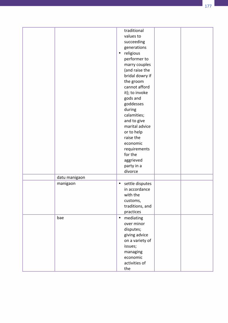
177
180
Iraya andlegalmatters
MangyanTadyawan
pagkatifunan • administratorofjustice,arbiterofdisputes,decidesswiddensites;occasionalmedicineman
Manobo datu • mediatorandarbiter
• judge—tohearcasesandimposepenalties;toensurethatthepenaltyorfine(tamokormanggad)ispaidimmediately
• maintainerofpeaceandorderwithintheterritoryandpeacefulrelationswithotherterritoriesandsub-tribes
• spokespersonandambassadorofgoodwill
• provideroftheneedsofpeopleespeciallywhentheyfaceshortages
• mediumforpassingon
181
traditionalvaluestosucceedinggenerations
• religiousperformertomarrycouples(andraisethebridaldowryifthegroomcannotaffordit);toinvokegodsandgoddessesduringcalamities;andtogivemaritaladviceortohelpraisetheeconomicrequirementsfortheaggrievedpartyinadivorce
datumanigaon manigaon • settledisputes
inaccordancewiththecustoms,traditions,andpractices
bae • mediatingoverminordisputes;givingadviceonavarietyofissues;managingeconomicactivitiesofthe
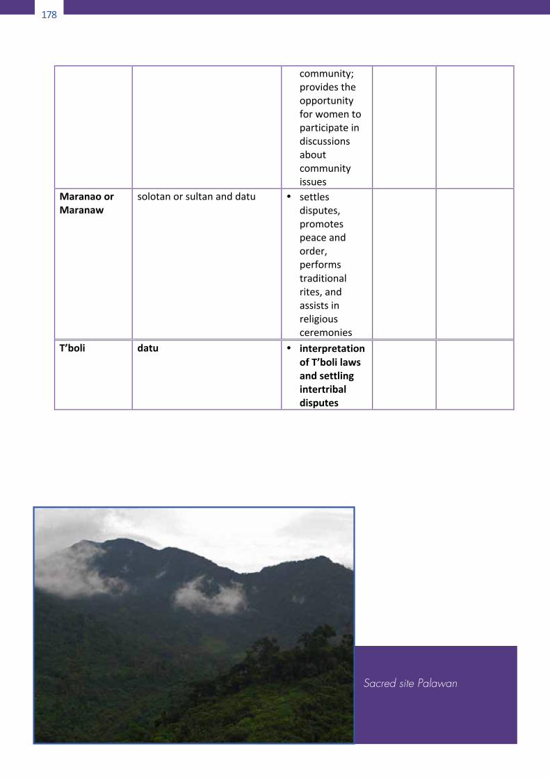
178
182
community;providestheopportunityforwomentoparticipateindiscussionsaboutcommunityissues
MaranaoorMaranaw
solotanorsultananddatu • settlesdisputes,promotespeaceandorder,performstraditionalrites,andassistsinreligiousceremonies
T’boli datu • interpretationofT’bolilawsandsettlingintertribaldisputes
Sacred site Palawan
179
182
community;providestheopportunityforwomentoparticipateindiscussionsaboutcommunityissues
MaranaoorMaranaw
solotanorsultananddatu • settlesdisputes,promotespeaceandorder,performstraditionalrites,andassistsinreligiousceremonies
T’boli datu • interpretationofT’bolilawsandsettlingintertribaldisputes
Sacred site Palawan 183
Appendix23
ImpactofClimateChangeonIndigenousPeopleLivinginTropical
andSub-tropicalEcosystems
There aremore than 1,400 distinct indigenous peoples in theseecosystems,mostofwhomarehuntersandgathererslivingintheworld’stropicalrainforestsandrotationalagriculturistsorshiftingcultivators. Most of forest peoples, majority of whom areindigenous peoples, are highly dependent on forest ecosystem.Therearealsofisherfolksandlowlandfarmersfoundintheplainsof these ecosystems. Such ecosystems are found in Asia, LatinAmerica,AfricaandsomepartsofAustralia.Mostofthecountrieswhere these ecosystems are found are considered as mega-diversecountries.Climatechangebroughtaboutthefollowing:• The practice of rainfed agriculture which characterizes
rotational agriculture or swiddening is highly disturbedbecauseofinfrequentrains,shorterwetseasonsorprolongedmonsoons leading to lowercropyieldsexacerbatedby longerlivesofpestsandoccurrenceofnewpests. Seedgerminationand seed life are altered. Schedules and performance ofcultural rituals which accompany agricultural seasons fromplanting,weedingtoharvestsaredisturbed.
• Changesinthebehaviorandmigrationpatternsofbirdswhichhave been traditionally used to guide hunters and markagricultural seasons causing disorientation of hunters andgatherersandshiftingcultivators.
• Worsening drought conditions and desertification, leading tolesser availability of drinking water, increased numbers offorestfirescausingrapid lossofforestcover,adverse impactson indigenous land rights and gathering livelihoods; and aseriouslossofbiodiversity, includingtraditionalmedicinalandritualplants.
• Changes in habitation of living areas and movements awayfrom communities beset with diseases, areas prone tolandslides,droughtsorfloodshavecausedculturaldisruptionsbecausesacredareasorgroveshavetobeabandoned,practiceof traditional livelihoods cannot continue any longer andculturalritualsrelatedtoagriculturalandforestrypracticesarepracticedlessandless.Landrightsandcustomarylandtenuresystemsareunderminedandviolated.
180
184
• Rainfall has become infrequent and unpredictable causingchanges in flood patterns of rivers affecting the regularroutines of indigenous peoples, particularly women andchildren,whocatchfishandotherwatercreaturesforfood.
• Increase in incidences of vector-borne diseases, such asmalariaanddenguefever,becauseofincreasingtemperaturesand deforestation. Warmer forests are favorable habitats formosquitoesactingasvectors.Newdiseasessuchasmeningitis,whichwere not endemic andwidespread, emerged inGhanaandothertropicalcountries.
• Increasedfloodinlowlyingareasbecauseofdeforestationhasledpeople inthoseareastoevacuateoradopttheir lifestylestoconstantflooding.
Sibura
181
184
• Rainfall has become infrequent and unpredictable causingchanges in flood patterns of rivers affecting the regularroutines of indigenous peoples, particularly women andchildren,whocatchfishandotherwatercreaturesforfood.
• Increase in incidences of vector-borne diseases, such asmalariaanddenguefever,becauseofincreasingtemperaturesand deforestation. Warmer forests are favorable habitats formosquitoesactingasvectors.Newdiseasessuchasmeningitis,whichwere not endemic andwidespread, emerged inGhanaandothertropicalcountries.
• Increasedfloodinlowlyingareasbecauseofdeforestationhasledpeople inthoseareastoevacuateoradopttheir lifestylestoconstantflooding.
185
Appendix24
ImpactofClimateChangeonIndigenousPeopleLivinginCoastalandMarineEcosystems
Sea level rise due to melting of glaciers and sea-ice and theexpansionofwaterbecauseofariseintemperatureresultsinthefollowing:• Cause some low-lying coastal areas to become completely
submerged,whileotherswillincreasinglyfaceshort-livedhigh-water levels. These anticipated changes could have a majorimpactonthelivesofindigenouspeoples.Theymayhavetoberelocatedoutsideoftheirtraditionalterritories.
• The small island developing states (SIDS) will be especiallyvulnerable to the effects of sea level rise, and to changes inmarine ecosystems, because of their major dependence onmarineresources(UNEP,2002).
• The sea has an enormous capacity to store heat. Warmerwater, combinedwith anticipated changes in ocean currents,could have a devastating impact on marine ecosystems andbiodiversity.
• Onepotential result could be a reduction in theupwellingofnutrients and phytoplanktons, which would in turn reduceproductivity in key fishing areas where many indigenouspeopleslive.
• Decreased growthmay also be seen in coral reefs,with highconcentrations of carbon dioxide in the water impairing thedeposition of limestone required for coral skeletons (UNEP,2002). Island communities, who rely on coral reefs, will beespeciallyvulnerable.
• Coral bleaching due to warmer sea temperature causesuncertainty and loss of livelihoods of fisherfolk because ofdifficultiesinmaintainingtheviabilityoffishandothermarinefloraandfauna.
• Lossofcoralreefsdecreasesmarinelife,underminesshorelineprotectionandlossofmedicinalplantswhichdependoncoralreefs.
• Coastal erosion is exacerbated by sea-level rise; strongerhurricanesandtyphoonsleadtolossoflandandpropertyanddislocation of indigenous peoples. The phenomenon ofindigenous peoples becoming environmental refugees have
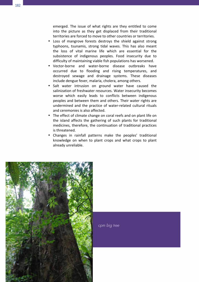
182
186
emerged. The issue ofwhat rights are they entitled to comeinto the picture as they get displaced from their traditionalterritoriesareforcedtomovetoothercountriesorterritories.
• Loss of mangrove forests destroys the shield against strongtyphoons, tsunamis, strong tidal waves. This has also meantthe loss of vital marine life which are essential for thesubsistence of indigenous peoples. Food insecurity due todifficultyofmaintainingviablefishpopulationshasworsened.
• Vector-borne and water-borne disease outbreaks haveoccurred due to flooding and rising temperatures, anddestroyed sewage and drainage systems. These diseasesincludedenguefever,malaria,cholera,amongothers.
• Salt water intrusion on ground water have caused thesalinizationoffreshwaterresources.Waterinsecuritybecomesworse which easily leads to conflicts between indigenouspeoplesandbetweenthemandothers.Theirwaterrightsareundermined and the practice ofwater-related cultural ritualsandceremoniesisalsoaffected.
• Theeffectofclimatechangeoncoralreefsandonplantlifeonthe island affects the gathering of such plants for traditionalmedicines, therefore, thecontinuationof traditionalpracticesisthreatened.
• Changes in rainfall patterns make the peoples’ traditionalknowledge on when to plant crops and what crops to plantalreadyunreliable.
cpm big tree

183
186
emerged. The issue ofwhat rights are they entitled to comeinto the picture as they get displaced from their traditionalterritoriesareforcedtomovetoothercountriesorterritories.
• Loss of mangrove forests destroys the shield against strongtyphoons, tsunamis, strong tidal waves. This has also meantthe loss of vital marine life which are essential for thesubsistence of indigenous peoples. Food insecurity due todifficultyofmaintainingviablefishpopulationshasworsened.
• Vector-borne and water-borne disease outbreaks haveoccurred due to flooding and rising temperatures, anddestroyed sewage and drainage systems. These diseasesincludedenguefever,malaria,cholera,amongothers.
• Salt water intrusion on ground water have caused thesalinizationoffreshwaterresources.Waterinsecuritybecomesworse which easily leads to conflicts between indigenouspeoplesandbetweenthemandothers.Theirwaterrightsareundermined and the practice ofwater-related cultural ritualsandceremoniesisalsoaffected.
• Theeffectofclimatechangeoncoralreefsandonplantlifeonthe island affects the gathering of such plants for traditionalmedicines, therefore, thecontinuationof traditionalpracticesisthreatened.
• Changes in rainfall patterns make the peoples’ traditionalknowledge on when to plant crops and what crops to plantalreadyunreliable.
184
MANUAL OF PROCEDURES Biodiversity-enhanced Strategic Environmental Assessment
Biodiversity Management Bureau Department of Environment and Natural Resources
Ninoy Aquino Parks and Wildlife Center North Avenue, Diliman, 1100 Quezon City Tel No: 02 376-4734 |Fax No: 02 376-4734 www.bmb.gov.ph | [email protected]
with support from
Biodiversity Partnership
Department of Environment and Natural Resources
Global EnvironmentFacility
United NationsDevelopment Programme